Dissertationes Archaeologicae
ex Instituto Archaeologico
Universitatis de Rolando Eötvös nominatae Ser. 3. No. 8.
Budapest 2020
Universitatis de Rolando Eötvös nominatae Ser. 3. No. 8.
Editor-in-chief:
Dávid Bartus Editorial board:
László Bartosiewicz László Borhy Zoltán Czajlik
István Feld Gábor Kalla
Pál Raczky Miklós Szabó Tivadar Vida
Technical editor:
Gábor Váczi Proofreading:
Szilvia Bartus-Szöllősi Zsófia Kondé Márton Szilágyi
Aviable online at http://ojs.elte.hu/dissarch Contact: dissarch@btk.elte.hu
ISSN 2064-4574
© ELTE Eötvös Loránd University, Institute of Archaeological Sciences Layout and cover design: Gábor Váczi
Budapest 2020
Articles
Maciej Wawrzczak – Zuzana Kasenčáková 5
Stará Ľubovňa – Lesopark. Late Palaeolithic site and the problems associated with raw material mining
Attila Péntek – Norbert Faragó 21
Chipped stone assemblages from Schleswig-Holstein (North Germany) in the collection of the Institute of Archaeological Sciences – ELTE Eötvös Loránd University
Bence Soós 49
Middle Iron Age Cemetery from Alsónyék, Hungary
Tamás Szeniczey – Tamás Hajdu 107
Appendix – Results of the analysis of the Early Iron Age human remains unearthed at Alsónyék, Hungary
Lajos Juhász – József Géza Kiss 111
Bound in bronze – a Roman bronze statuette of a barbarian prisoner
Csilla Sáró 117
The fibula production of Brigetio: clay moulds
Field Reports
András Füzesi – Knut Rassmann – Eszter Bánffy – Hajo Hoehler-Brockmann – Gábor Kalla – Nóra Szabó – Márton Szilágyi – Pál Raczky 141 Test excavation of the “pseudo-ditch” system of the Late Neolithic settlement complex
at Öcsöd-Kováshalom on the Great Hungarian Plain
Gábor Váczi – László Rupnik – Zoltán Czajlik – Gábor Mesterházy –
Bettina Bittner – Kristóf Fülöp – Denisa M. Lönhardt – Nóra Szabó 165 The results of a non-destructive site exploration and a rescue excavation at the site
of Pusztaszabolcs-Dohányos völgy északi part
Dávid Bartus – László Borhy – Szilvia Joháczi – Emese Számadó 181 Excavations in the legionary fortress of Brigetio in 2019
Ferenc Barna – Anita Benes – Szilvia Joháczi – Rita Olasz – Melinda Szabó 189 Excavations in Brigetio in 2020
Thesis Abstracts
Anett Osztás 205
The settlement history of Alsónyék–Bátaszék.
Complex analysis of its buildings in the context of the Lengyel culture
Csilla Száraz 229
The region of the Zala and Mura Rivers (Zala County) in the Late Bronze Age.
Late Tumulus and Urnfield period
Ágnes Király 239
Human remains unearthed in settlement context from the Late Bronze Age – Early Iron Age (Reinecke BD–HaB3) Northeastern Hungary
Gergely Bóka 243
Transformation of settlement history in the Körös Region in the period between the Late Bronze Age and the end of Iron Age
Gabriella G. Delbó 263
Pottery production of the settlement complex of Brigetio
Adrienn Katalin Blay 281
Die Beziehungen zwischen dem Karpatenbecken und dem Mediterraneum von der II. Hälfte des 6. bis zum 8. Jahrhundert n. Chr. anhand Schmuckstücken und Kleidungszubehör
Levente Samu 293
Die mediterranen Kontakte des Karpatenbeckens in der Früh- und Mittel- awarenzeit im Licht der Männerkleidung. Gürtelschnallen und Gürtelgarnituren
Reviews
Gábor Mesterházy 299
Czajlik, Z. – Črešnar, M. – Doneus, M. – Fera, M. – Hellmith Kramberger, A. – Mele, M. (eds): Researching Archaelogical Landscapes Across Borders – Strategies, Methods and Decisions for the 21th Century. Graz–Budapest, 2019.
Complex analysis of its buildings in the context of the Lengyel culture
Anett Osztás
Institute of Archaeology, Research Centre for the Humanities
osztas.anett@abtk.hu
Abstract
Abstract of the PhD thesis1 submitted in 2019 to the Archaeology Doctoral Programme, Doctoral School of History, Eötvös Loránd University, Budapest under the supervision of Eszter Bánffy.
Introduction
At the turn of the 6th–5th millennium BC significant transformations took place in Central Europe. Signs of change already appeared in the second half of the LBK (Linearbandkeramik or Linear Pottery Culture) period, by the end of which communities with a new kind of mate- rial culture emerged. For a certain extent, this shift standardized the way of life even through archeologically different regional groups or cultures. Based on the archaeological evidences this so-called post-LBK era can be characterized by changes in the social organization, new house structures, increasing variety and quantity of grave goods placed in burials, and build- ing monumental circular ditches. As a result of the growing demand for various stone and exotic raw materials, diverse and complex systems of relationships have emerged between the communities which left a particular imprint on the archaeological materials.
In relation to these changes, in the first half of the 5th millennium BC, some parts of the Czech Republic, Lower and Upper Austria and roughly the western part of the Carpathian Basin were populated by communities using painted pottery. This is called the Lengyel culture, in reference to the eponymous Hungarian site, however various local names also exist. Many of the characteristics of this culture were rooted in the preceding era of the LBK, and were also influenced by various other cultures around. The development of the Lengyel complex and its dynamics were not uniform in each region, as they differed in their geographical situation, their cultural heritage and their traditions, resulting in the formation of regional groups.
The research of the Lengyel culture has been started 130 years ago in Hungary by Mór Wos- insky, at the same time when Jaroslav Palliardi identified the Moravian Painted Pottery in Moravia. At the beginning the emphasis was on identifying different material finds and later on deciphering the internal periodization of the culture. As a result, the first typochrono- logical schemes were created, and these have been undergoing continuous refinement and
1 The full version of the manuscript of the PhD dissertation is available online, in Hungarian: https://edit.elte.
hu/xmlui/handle/10831/50383
modifications ever since.2 However, absolute chronological studies have been uneven, as only conventional or individual data are available from most of the sites. For the time being, a com- prehensive statistical evaluation of a larger series of AMS radiocarbon dates has only been completed in Austria, for the Alsónyék–Bátaszék site, and further Lengyel sites have been discussed by Bayesian statistics recently.3
Behind the changes of the post-LBK period a number of technological innovations can be presumed, including in architecture. Nevertheless, investigation of architecture is one of the neglected fields in the research of the Lengyel culture. Due to the lack of excavated houses in certain areas and that of detailed processing of the available sources, research such as the architectural exploration of the Central European LBK that has a long history and tradition could not been developed. Until 2003, Zengővárkony was the only site in Hungary where a house was known from the classical phase of the Lengyel culture.4 So far, with the exception of Slovakia, there has not been a sufficient number of excavated remains of houses which would have enabled a more accurate architectural analysis. Instead of the systematic cata- loging of the ca. 150 buildings, two articles provided insight into Lengyel culture architecture in Slovakia.5 Remains of 18 Lengyel houses have been excavated in the Czech Republic at Hulín-Pravčice-Višňovce site recently.6 Due to the small number of house plans found in Aus- tria and their dating uncertainties, it is difficult to compare them with typical timber-framed Lengyel houses.7 This is quite similar to the house plans uncovered in northern and western Transdanubia, where the associated finds also raise numerous typological and chronological questions in the contact zone of the various regional groups.8 Therefore the remains of the 122 above-ground timber-framed houses excavated at Alsónyék–Bátaszék site provide a unique opportunity to study the characteristics of the Lengyel architecture in detail, which is the main topic of this thesis.
Aims, sources and methods of the dissertation
The doctoral thesis was largely based on a rescue excavation conducted at various subsites of the Alsónyék–Bátaszék site between 2006 and 2009.9 On an area of ca. 25 hectares, 122 above- ground, timber-framed buildings, approximately 2300 burials and hundreds of settlement fea- tures were uncovered which in this composition had been unknown until then in the entire distribution area of the Lengyel culture. Since the excavations, processing started along sever- al lines, focusing not only on the finds from the Late Neolithic, as the settlement and its sur- roundings covered almost the entire Neolithic in Hungary, yielding substantial archaeological record and find material from the Starčevo, LBK, Sopot and Lengyel periods (Fig. 1).10
2 More recently, for example: Kalicz 2003; Lichardus – Vladár 2003; Čižmář et al. 2004; Pavúk 2007; Zalai- Gaál 2010.
3 Stadler – Ruttkay 2007; Osztás et al. 2016b; Regenye et al. 2020.
4 Dombay 1960.
5 Pavúk 2003; Pavúk 2012.
6 Kalábková 2012.
7 Lenneis – Rammer 2017.
8 T. Németh 1994; M. Egry 2001; M. Egry 2003; M. Virág – Figler 2007.
9 Osztás et al. 2016a, 11. Fig. 3.
10 For a summary of each period and the archaeological processing so far, see: Bericht der Römisch-Germani- schen Kommission volume 94 (2013), 2016.
The thesis is mostly focusing on late Neolithic architecture at the site. Thus the main part of this work covers the analysis of all 122 houses excavated from the Lengyel period. For this it was necessary to create a complete house catalogue, without which the architectural evalu- ation would not have been possible. While completing the analysis I was looking to find the answers to how the architecture of the Lengyel culture at Alsónyék could be characterized.
Were the house plans suitable for uncovering potential technological changes? Could these changes be identified by studying the structure of houses over the course of the ca. 400 years when the Lengyel settlement existed? Did this analysis of the buildings make it possible to discuss the chronological issues of the settlement? An important question was how defining the house locations and their constructions formed the complex settlement structure, and what kind of considerations the community could make while forming it. In addition to ana- lyzing the technology, what further opportunities are there for studying the social aspects of the architecture? From the dimensions of the buildings what conclusions could be drawn on a technological and social level? The most important base for answering these questions was the morphological evaluation of the excavated house plans, supplemented by the quantitative analysis of metric data. Investigating remains of the burnt daub fragments unearthed in post- holes and in other settlement features also contributed to the results.
Architectural monuments are basically material remains, but they certainly have wider sig- nificance. In addition to technological advances that influence the environment, they reflect the background of the customs and ideologies of communities. The greatest difficulty of in- terpreting architectural remains is to decipher this very aspect. From the 1990s, research of houses and their surroundings have changed in a way as to emphasize the fact that a house Fig. 1. Location of the Alsónyék–Bátaszék site and the plan of the excavations with the spatial distri- bution of cultural groups on the different subsites and areas.
is a complex find with many social and symbolic aspects.11 A house should be viewed as an organic unit, and be seen as a living, active being with a life cycle, having major stages similar to those of human life.12 Through this approach, we can get closer to understanding the func- tion and significance of the house in the life of Neolithic communities. Another significant recognition of these new approaches was that a house was a find itself, and e.g. the debris was also an important, valuable part of it. With this, research of the burnt daub fragments has also become more significant. There are numerous possibilities to study those, such as macroscopic examinations and thin sections.13 Oriented by these approaches, I have carefully examined the houses, also within the context of the Lengyel culture, using accessible architectural data of the excavated houses, primarily related to the eastern distribution area and to the classical period of the culture (such as Veszprém-Jutasi út, Zengővárkony, Santovka, Svodín, Žlkovce sites).14 The other major part of the thesis is to map the late Neolithic settlement history of the site.
From this complex issue, due to the current state of the archaeological processing, it is only possible to highlight certain topics for the time being. Outside the houses the most important components of the settlement, such as different pits, ditches and grave groups, are in focus here. Even without a typological analysis of the finds unearthed from them, many aspects of their function and social significance can be understood. Studying these larger structures can reveal different social perspectives of the community that lived at the site as well as the spatial differences within the settlement. For the study of the settlement structure, it was important to review the pits and examine their spatial location in order to determine whether there were any of them that could be classified as belonging to the houses. What features could be as- signed to each building and what could have been their function? Is there a pattern which may show some kind of regularity between the houses and the pits that indicate possible outdoor activities or storage facilities around the house? An other important aspect to the examination of pits was studying their filling processes. The analysis of the layers and the finds found in them may shed light on contemporary social practices and rules of deposit, and can lead to significant conclusions about human behavior in this context.15 Clay extraction pits, as some of the largest units in the settlement structure, were especially investigated in a thorough way.
I have discussed them along the excavated subsites in detail to map the possible differences within the site.
The ca. 2300 uncovered burials, a large part of which were arranged in grave groups, also have left a particularly spectacular impression on the settlement structure. Interpreting and ana- lyzing burial groups is an exciting research topic: the matter of chronology, the question who were buried in a given group, or how these groups shaped the layout of the settlement, are just a few of the important issues. Finally, the trenches unearthed at the excavations were also presented. Examination of the settlement structure has been further expanded by discussing the results of the geophysical prospecting carried out at the site between 2011 and 2014. For the moment, only the results of the radiocarbon measurements and the typochronological analysis of a small portion of the grave ceramics provide data about the chronological frame-
11 Hodder 1990; Bailey 1990; Tringham 1995; Bailey 1996; Stevanović 1997; Perlès 2001; Nanoglou 2008;
Naumov 2013; Souvatzi 2013; Bickle et al. 2016.
12 Tringham 1995, 98; Bailey 1996, 146.
13 Tringham – Krstić 1990; Stevanović 1997.
14 Dombay 1960; Pavúk 1991; Pavúk 1994; Pavúk 2003; Regenye 2004; Regenye 2007; Pavúk 2012.
15 Schiffer 1987; Chapman 2000a; Chapman 2000b.
work of the site. The environmental settings as an integral part of the settlement history are also dicussed based on the geographical literature and by the analysis of the natural scientific investigations carried out so far.
Results
Architecture
One of the results of my work is the identification of 51 further houses, in addition to the 71 excavated ones, through a detailed investigation of all the documentation, drawings and maps of the excavation (Fig. 2). Another important outcome is the birth of the house catalogue, for which preparing the drawings of the houses was already a significant part of the analytical work.16 Creating it resulted in an essential source material for the identification of the struc- tural elements of each house and a detailed morphological analysis of them. Structure, dimen- sions and other features provided an important base not only for investigating the technolog- ical aspects, but also for studying the social dimensions of the architecture.
Of the 122 houses, based on how well-preserved their structural elements were, 35 could be considered as more or less complete (A category). 8 houses had an incomplete ground plan (6%), but their main dimensions (minimum width, maximum width, length of the longitudinal wall/walls) were measurable (A/B category). The majority of houses were incomplete and, therefore, not every type of data included in the analysis were measurable on their ground plans (B category: 65% = 79). These were not suitable for detailed architectural analysis, but they have still provided useful information about the layout of the settlement.
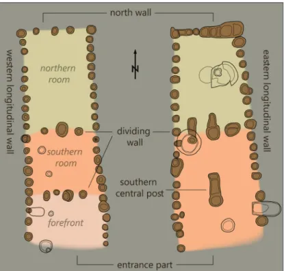
The Lengyel houses were above-ground, timber-framed houses, which was a typical construc- tion practice in continental climate areas during the Neolithic.17 The main frame consisted of a densely dug-in wooden structure the rigidity and stability of which were provided by vertical columns (Fig. 3). For the sake of simplicity, I have used the four principal points of the compass when naming the wall sections making up the outer frame of the houses. The orientation of the buildings is basically characterized by a smaller or greater westwards deviation from the North-South axis. Based on that, the outer frame of a Lengyel house base module is formed by longitudinal wall sections (“western” and “eastern” longitudinal walls) and a transverse wall (the “north” wall) on the northern side (Fig. 3). Inside most houses, there were one or two transverse rows of posts (dividing wall/walls). In addition, there was also a large pillar on the south side of the house (southern central post). The entrance was at the southern part of the house, and until now has been reconstructed with an entrace open from the south in the relat- ed literature.18 During my analysis it has turned out that the front was not necessarily open, as four different types of entrance constructions could be identified in 28 cases.
By the analysis of the remains of the burnt daub fragments, the construction of the wall and of certain other structures consisted of twigs, branches or reeds interwoven vertically and/or horizontally (Fig. 4). This structure was daubed with clay layers of different thicknesses. This
16 The AutoCAD map of the excavation was the starting point for those drawings. The catalogue contains the detailed description of every house accompanied by a graphics in 1:150 scale. For easier comparison the structural elements of each building and their various parameters were recorded in a Summary Table as well.
17 e.g. Tringham 1971; Tálas – Raczky 1987; Stevanović 1997; Barabás – Gilyén 2004, 60; Raczky et al. 2007.
18 Pavúk 1991; Pavúk 2003; Regenye 2004; Regenye 2007; Pavúk 2012.
Fig. 2. The plan of the excavations with the ground plans of the 122 houses uncovered.
construction technique was wide- spread from the Neolithic right until the 20th century in Hunga- ry.19 From the houses, during the large-scale rescue excavations, usually only the remains of their foundations reaching down into the subsoil have been preserved.
At Alsónyék, it became possible to identify which might have been floor fragments and large surfaces with burnt daub pieces belonging to the houses. These data provide important informa- tion not only about the original depth of the floor level, but also about whether the house was burnt down or not. This, comple- mented by the careful analysis of
19 see footnote 17.
Fig. 3. Ground plans of typical Lengyel houses from Alsónyék.
Fig. 4. A selection of burnt daub fragments from postholes of house 109.
the fillings of the postholes, showed that altogether 27 houses were probably burnt down at Alsónyék. This also raises the issue of deliberate house burning, similar to those widely ob- served in Southeast Europe, which has never been systemati- cally studied on houses of Lengyel culture.20
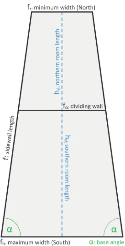
On the houses, where possible, I undertook various further examinations using methods of elementary geometry. This was essential because the calculations could reveal which (mainly dimensional) parameters of a house were related to each other and how. Some interesting patterns have emerged, pointing to possible construction principles and techniques the builders used. The basis for this analysis was the empirical fact that the geometric shape determined by the post struc- ture of the houses always formed an (approximately) sym- metrical trapezoid. To make the various calculations the fol- lowing four basic sizes were used: the length of the side wall/
walls, the maximum width of the house, the minimum width of the house and the length of the northern room. From these I’ve created the geometric model of each house, which has allowed for „virtually reconstructing” incomplete buildings, making it possible to draw important conclusions about those
as well (Fig. 5).21 This way I could expand the range of houses to be examined. For a compre- hensive analysis data from a total of 40 buildings were taken into account, the basic sizes of which were all measurable. Using these, I analyzed the relationships between different dimen- sional parameters of the houses, uncovering their otherwise invisible connections mainly by different types of diagrams.22
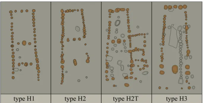
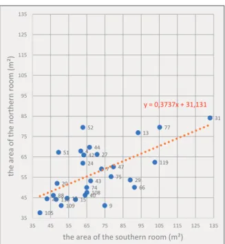
By investigating morphological and metric characteristics of the houses we could make sev- eral observations. The buildings at Alsónyék could be divided into three basic types according to their ground plans: houses with two dividing walls (type H1), houses with one dividing wall (type H2) and houses without a dividing wall (type H3). As a separate type, I also discuss houses with extra room or rooms (type H2T), where the main building does not differ struc- turally from the basic form (Fig. 6). The most common type were the houses with one partition wall (51 cases) which divided the house into a northern and a southern room. In most of the cases examined, the southern room was longer. The calculations also revealed that in most in- stances (22 out of 29) the southern room also had a larger area than the northern room (Fig. 7).
Behind this we can suspect some kind of intention from the builders that might have been related to the location and/or function of the southern room.
By the time of the post-LBK era the general layout and the shape of the houses substantially transformed, and trapezoid ground plans became widespread with regional versions related to particular archaeological cultures.23 The significance of the trapezoidal shape is not clear so far.
20 Tringham 1995; Stevanović 1997.
21 This figure is a simplified version of the one in the dissertation, adapted to this text.
22 In the dissertation more than 30 various calculations have been performed between the parameters of the houses, represented on diagrams, but here only a few of those can be presented.
23 e.g. Hampel 1989.
fr: minimum width (North) minimwidth (North)
fh: maximum width (South)
hd: southern room lengthhé: northern room length
α α
:
fo: dividing wall
α: base angle
Fig. 5. The main parameters of a Lengyel house from Alsónyék used in the text.
In the explanations it’s often mentioned that it might have provided structural stability to the house, related to the prevailing wind direction.24 The shape of the Alsónyék houses was also slightly trapezoid which differs from the practice known in Slovakia from the same period, where interestingly the rectangular form was typical.25 But the base angle ”α” (Fig. 5) of the trapezoid (the angle of the side walls and the southern base) varies in a very narrow range:
between 85.9 degrees (House 109) and 89.3 degrees (House 24). Thus one of the most important questions is what might have been the role of this consistently, yet only slightly trapezoidal form. As a consequence, the house expands from the inside towards the entrance in the shape of a funnel, which could also have been a benefit somehow. For example the function of the southern room may have required more space and light. The trapezoidal shape might also have been related to the general construction of the house, and in particular to the shape of the roof.26 The problematic effects the trapezoidal shape had on the roof structure is discussed in detail in the dissertation.
Compared to the houses of the LBK era, the research tells us about a new architectural inno- vation during the Lengyel period.27 According to Juraj Pavúk the phenomena observed at the Budmerice site (Slovakia, Lengyel IV period) proves beyond doubt that the main novelty of the Lengyel culture architecture was the use of a new roof structure. This means that the upper sto- rey which was supported by a large pillar made it unnecessary to use additional columns in the interior.28 In this new structure (called “rafter roof structure” or “Sparrendach” in German ter- minology) the rafters running in the roof planes were connected horizontally by tie beams, so that the triangular structure transferred the weight of the roof vertically to the side walls.29 The typical house plans at Alsónyék raise several questions about the possible roof construction,
24 Coudart 1998; Coudart 2013.
25 Pavúk 2003; Pavúk 2012.
26 Carter 2009.
27 Pavúk 2003, 456, 466–467; Raczky et al. 2007, 26.
28 Pavúk 2003, 456, Abb. 2; Ďuriš 2011.
29 Masuch – Ziessow 1985, 64; Lichter 1993, 61–63; Raczky et al. 2007, 26.
Fig. 6. The main types of Lengyel houses excavated at Alsónyék.
and it is not clear yet exactly how the structure looked like. On the basis of the revealed struc- tural elements, there might have been some specific functional reason for the difference in layout between the southern and northern rooms. It is also not known yet what effect the slightly trapezoidal shape of the houses had on the roof structure. These questions could only be solved by a house reconstruction that would take static considerations into account.
The size of the houses revealed that the com- munity had built houses of relatively uniform size. Of the three basic sizes, only the largest width could be used to determine some po- tential groups. The calculations also showed that there is a strong correlation between the length of the house and its maximum width (Fig. 8). It is likely that the builders could have
planned the length of the house in advance, and the maximum width of the house may have been more important than the minimum width. There may have been practical reasons for this, such as the structural limitations of the roof structure: the maximum width of the house could not be greater than the width of the roof they could build, depending on the static considerations or the building materials available. 10 cases of renewals and superpositions, observed during the evaluation (8 of them on subsite 10B), were likely to be associated with generation changes have shown that larger houses have always been built than in the previ- ous phase. This may have been triggered by the need for greater living space, accompanied by population growth during the duration of the settlement.30
30 A model for estimating the size of the Lengyel population at Alsónyék, see: Bánffy et al. 2016.
4 7
12 9
13
15 20 22
24 27
29
31
40 42
43 44
47 51
52
66 74
75
77
88 105
108 118109
119
y = 0,3737x + 31,131
35 45 55 65 75 85 95 105 115 125 135
35 45 55 65 75 85 95 105 115 125 135
the area of the northern room (m²)
the area of the southern room (m²)
Fig. 7. The area of the northern and the southern rooms (m²).
63
105 22
34 109
11888 30
12 20 51
15 33
108 43
4 9 44
42
24 40
52
74 29
147 35 47
49 76
75 66
27 119
13
19 21
77
31
45
y = 0,1471x + 4,396
6 6,5 7 7,5 8 8,5 9
12 13 14 15 16 17 18 19 20 21 22 23 24 25 26 27 28 29
maximum width, fh(m)
wall length, f (m)
Fig. 8. The side wall length and the maximum width of the houses (m).
The direction of the houses reflects a very consistent orientation system throughout the set- tlement. The houses all had a uniform NNW–SSE alignment, with slight variations across the entire settlement. The privileged role of the south direction is indicated by the entrance of the buildings and the orientation of the burials whose face were facing also south. The houses at Alsónyék reflect an integrated architectural technology and tradition. By the analysis of the excavated ground plans, the architectural solutions appear to be relatively uniform. In the course of the house building certain criterion and rules seems to have prevailed, and it did not become necessary to change them substantially during the existence of the settlement.
However, we can not consider the houses at Alsónyék as products of a highly advanced and completely mature, standard building practice. It should not be ignored that the architectural forms and their arrangement in space are the result of a gradual development and the collec- tive effort of the people who were creating them over a long period of time. A house does not only represent stability, continuity and an unchanging past, but is also a driving force behind change, and a primary source of various personal and family memories, and creation of stories shared by the community. The most consistent and significant common element that connects spatial and temporal patterns is the central and ongoing significance of the house, making it one of the most important units of social structure.31
Due to the small number of the building remains from the western areas, it is currently not possible to ascertain what characterized the architecture in general throughout the Lengyel circle. The differences between the regions may be down to local cultural roots, making espe- cially the peripheral, non-primary distribution areas stand out.32 The closest form and struc- tural parallels of the Alsónyék houses are those discovered on the Veszprém-Jutasi út, Svodín, Žlkovce, Santovka and Hulín-Pravčice sites, and dated to the Lengyel II period. This confirms not only the similarity of burial practices, but also the uniformity of the eastern group in the architectural tradition. Houses discovered in Moravia in Hulín-Pravčice site prove that the same type of construction also existed in the western spread of the Lengyel world. The Veszprém data show similarities in the size of the houses in Alsónyék. The widths of 7–8 me- ters listed there correspond approximately to the widths of the houses of Alsónyék, and the lengths of 18–32 meters of Veszprém houses also correlate relatively well with the records from Alsónyék.33 Comparison of the data of houses uncovered in Slovakia and Moravia with those at Alsónyék shows that there were no big differences in size between them, although there are some longer buildings occur in both areas.34
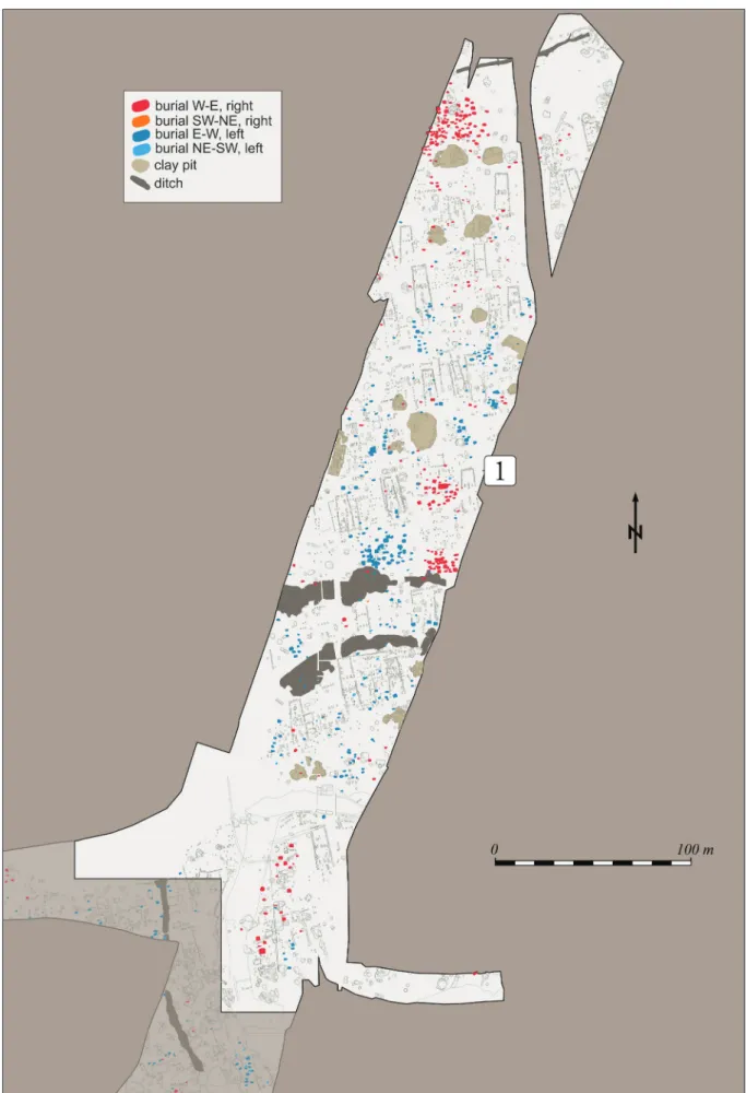
Spatial patterns: pits, burials, ditches
Apart from the houses, the main components of the settlement structure at Alsónyék are pits, ditches and graves (Fig. 9: subsite 10B).35 At the beginning of the excavations, it appeared that there was a large pit on the north side of each house that may have been associated with the building next to it. After carefully studying the excavation documentation and the maps it turned out that this assumption was wrong, and it can be stated that no repetitive patterns
31 Souvatzi 2013.
32 Pavúk 2003.
33 Regenye 2004.
34 Karlovský – Pavúk 2002, Tab. 1a; Kalábková 2009, 115. Tab. 4.
35 A summary with precise age and type determinations of all the 14,729 excavated features is still being pro- cessed, therefore only those that can be securely classified as belonging to the Lengyel period at the moment are presented here.
Fig. 9. Clay extraction pits, ditches and burials with the main orientations highlighted on the plan of the northern excavation area (subsite 10B, area 1).
could be observed in terms of the pits so far. It is difficult to determine which pits might have belonged to a given house in a settlement as dense as this, because the simultaneity of a house and the nearby pits is not proved by their spatial relation. With a detailed analysis of the finds from the pits, perhaps a solution will emerge to this issue.
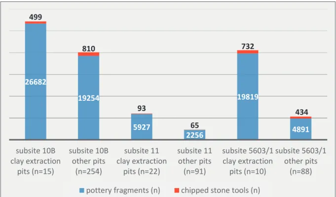
The number of the pits clearly suggest a more intensive activity on subsite 10B than on the other surfaces (Fig. 10). The amount of the two most common artefact types (ceramics and chipped stone tools) found in them are also more striking on subsite 10B. The large quantity of these two type of finds in the clay extraction pits showed that they were used extensively (Fig. 10). The same was confirmed by the observations made on the fillings of the clay extrac- tion pits. It is assumed that in and around them the community performed various everyday activities, and they could have been shared by larger groups. The analysis also showed that some clay exctraction pits might have had natural origins, i.e. they were created by deepening and widening an existing recess. This is also demonstrated by their extremely large dimension (the largest ones are approx. 30 meters long and 15–16 meters wide), sometimes their similar directions and by the geological analysis of one of them (subsite 5603/1, feature 203). These irregular type of pits were characteristic in particular of the southern part of subsite 11.
At the time of the LBK, there was a strong relationship between houses and the long pits flanking them. This has been observed even in settlements from the Stroke Pottery culture, but there must have been changes in the way settlements were organized because by the late Stroke Pottery culture these pits have been moved further away from the vicinity of the house.36 These structures and their immediate surroundings could have been shared activity areas by a larger community in everyday life. Layers strongly mixed with burnt daub frag- ments observed in the filling of several clay extraction pits at Alsónyék might have been
36 e.g. Frirdich et al. 2015; Končelová – Květina 2015; Vondrovský et al. 2016.
26682
19254
5927 2256
19819
4891 499
810
93
65
732
434
subsite 10B clay extraction
pits (n=15)
subsite 10B other pits
(n=254)
subsite 11 clay extraction
pits (n=22)
subsite 11 other pits (n=91)
subsite 5603/1 clay extraction
pits (n=10)
subsite 5603/1 other pits
(n=88) pottery fragments (n) chipped stone tools (n)
Fig. 10. Quantity of the two common artefact types found in clay pits and pits at each subsite.
related to some specific events. These phenomena could only be studied mostly in the north- ern part of subsite 10B and in the eastern long sector of subsite 5603/1. It is very likely that the debris of burnt houses were deposited here, hiding the remnants of previous activities, thus giving the impression of a more elusively built environment, as opposed to the tell sites.37 By the Late Neolithic mortuary practices significantly transformed which is reflected by the high number of burials and the concentration of graves in formal groups. Although solitary graves and burials deposited in pits also occur38, both larger and smaller burial grounds are typical within the Lengyel circle.39 This is characteristic of the eastern distribution area only, this regular form of burial is not known in the western areas (Austria, the Czech Republic, Western Transdanubia). The only exception is the smaller group uncovered in Friebritz-Süd, however its context is relatively special.40 In addition, mostly solitary graves that have been deposited in settlement features or some special contexts (so-called Sonderbestattungen) have been unearthed so far.41 In south-eastern Transdanubia some burial grounds are known, but Alsónyék stands out with its ca. 2300 uncovered burials. This number is partly due to the size of the explored area.
At the eastern area the research problem mainly springs from the fact that very few, if at all, complete grave groups have been excavated and no efforts have been made to study those in detail. These would require extensive bioarchaeological research on the one hand, and new, innovative social archaeological approaches meeting the challenges of modern archeology on the other. We know little also about the family relationships between men, women and children, and other aspects of human coexistence. Social archaeological studies related to the Lengyel culture have emerged in the 1980s by the works of István Zalai-Gaál.42 Lengyel grave goods were examined from the aspect of social structure, status and prestige lately.43 The an- other interesting issue is the temporal relationship between graves and other features, as they are not separated from each other spatially within the settlements. This phenomenon has not been studied either, usually due to the circumstances of the excavations.
The Lengyel community buried a large portion of their deceased in burial groups at Alsónyék as well, where a total of 92 groups have been identified (Fig. 9: subsite 10B). This classification was important primarily from a practical point of view because it facilitated the handling of the large amount of data. A part of the groups appeared to form well-separated clusters from their surroundings and seemed to be more compact than the others, while in other cases it was difficult to define the boundaries of the groups well. On average there were 25–40 buri- als in a group, while some larger ones included about 100. The distinctive sizes of the burial groups also suggest that there could have been different social intentions involved. It appears that within a burial group the community followed a strict burial rite. Although slight dif- ferences were often recorded in the alignments, within a group an overall coherence could be observed.
37 Borić 2008, 123.
38 Nĕmejcová-Pavúková 1986, 143; Pavúk 1994, 167, 169; Pavúk – Bátorá 1995, 112–114; Bistáková – Paži- nová 2010.
39 Dombay 1960; Kalicz 1985; Nĕmejcová-Pavúková 1986; Zalai-Gaál 2010.
40 Neugebauer-Maresch et al. 2002.
41 Urban 1979; Neugebauer-Maresch 1995, 93–99; Zápotoczká 1998; Podborský 2004, 279–280.
42 In summary, see: Zalai-Gaál 2010.
43 Siklósi 2013; Demján 2015.
Burial rite are basically dominated by burying the dead in contracted position, cremations were rare.44 The most common alignement of the deceased at the eastern sites is E–W and W–E, with the body lying on its left side in the former case and on its right side in the latter.
In Zengővárkony, the E–W orientation was observed in 175 of the 339 examined cases.45 At Svodín on the other hand, the W–E orientation was typical.46 At the Mórágy-Tűzkődomb site, ca. half of the burials were oriented similarly to Svodín (W–E).47
Approx. two-thirds of the burials securely classified as Lengyel period were in E–W orienta- tion (sometimes with slight variations) at Alsónyék, most of the rest were in W–E. Of course there were some others in various directions, but only in small numbers and these deceased were mostly deposited outside a grave group. An important question is what could have been the reason for the two different orientations. Therefore I investigated some burial groups by analyzing the frequency of occurrence of various grave goods within a group (ceramics, pol- ished and chipped stone tools, jewellry made from Spondylus, Dentalium and copper), select- ing a few groups of different orientation from each subsite. This statistics haven’t yet provided sufficient evidence for the reason behind the difference in orientation. Based on the above, it can be said that the same main grave goods occur in a nearly similar proportion in the two kind of groups. At subsite 10B the radiocarbon model showed no chronological differences between the three studied groups. With the investigated groups of subsite 11 the situation was the same, but the burial activity was as approx. two and a half times as long in these groups.
On subsite 5603/1 the largest group that was studied had been used for two times longer than the smallest one.48
Both the orientation of the graves and the groups, and the location of the groups suggested a strong relationship between houses and graves. The south direction had a distinguished role as the burials were also facing south, just as the house entrances. The grave groups uncovered in the continuation of the longitudinal walls of the houses (groups 56 and 57 on subite 5603/1) may have expressed the survival and continuity of the house or household in a symbolic sense (Fig. 11). The placement of the burials at the southern end of the houses, which also supports the privileged role of the southern direction, symbolically connect the two together as a place of family/household. It could also be a form of expressing and affirming family or household unity. However, this deliberate spatial arrangement could just as well refer to the relationship between the deceased and the living.
Two distinct types of ditches were found at the site. The first one had some sections explored along the three edges (northern, eastern and southern) of the excavated area (Fig. 9: for its northern section). Despite the fact that these were just small sections, their similar fillings and structural identity suggest that we can interpret them as parts of a large ditch that encircled the whole settlement.49 This also means that these sections of trenches marked the boundary of the late Neolithic settlement on three sides. The cross sections of the excavated trenches show a ca. 2 metres deep and 1–1.5 m wide ditch with V-shaped profile. No postholes were found at
44 Novotný 1962; Kalicz 1985, 33–35; Neugebauer-Maresch 1995, 98–99; Zalai-Gaál – Ódor 2008; Bistá- ková – Pažinová 2010; Zalai-Gaál 2010, 17–19; Zápotoczká 1998, 116, 127.
45 Dombay 1960, 196.
46 Nĕmejcová-Pavúková 1986, 144.
47 Zalai-Gaál 2010, 57. Tab. 4.
48 Osztás et al. 2016b, 224–226.
49 Similar ditch was excavated at site of Žlkovce: Pavúk 1991.
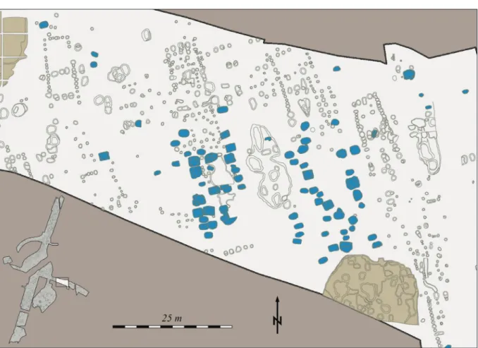
the bottom of the ditch, and there weren’t any traces of a structure indicating a row of posts or a palisade close to the ditch either. Small structures (approx. 3.5 metres long and 0.90–1 meter wide) crossed all three excavated trench sections perpendicularly, and at the bottom of those possible traces of a wooden structure could be detected. Exact parallels of these structures are known from the Sormás-Török-földek site, which were reconstructed as a wooden bridge.50 The two ditches unearthed in the middle of the northern part of the site could have had completely different roles. The excavation map and the magnetometer survey conducted out- side the uncovered area showed that they could have formed two large concentric circular structures at the northern area of the settlement (Fig. 12). Unfortunately a modern pipeline, that also crossed the northern part of the area, passed through here as well, near which the traces of the two ditches are completely lost. The magnetometer survey did not proceed southeast from here and outside the pipeline track.51 Its longer section was also excavated in the southern part of surface 10B, thus it was possible to connect the two excavated sections.
However, the area marked with a dashed line between the two uncovered sections, remained unexplored (Fig. 12).
These ditches, on the one hand, played an important role in the shaping and organization of the settlement, as it appears that the houses were oriented to follow their lines, similarly to Svodín site. On the other hand the ditches may have had the function and meaning of the
50 P. Barna 2017, 78, 80. Fig. 31.1,2.
51 For a summary of the surveys, see: Rassmann et al. 2020.
Fig. 11. Spatial location of houses 106 and 107 and burial groups 56 and 57.
classical circular trenches typical of the Lengyel culture, discovered in or near several other settlements in southeast Transdanubia.52 It is presumed that the circular layout around the ditches could only be found in the northern part of the settlement (subsite 10B), which sug- gests there were some special considerations taken into account for the use of this area. In the area enclosed by the inner ditch, burials with more distinct grave goods were found than in other parts of the site. This also confirms its prominent role as a center around which the houses were built (at least in this part of subsite 10B).
The specific physical connection between the circular ditch system and the houses, as in the case of Svodín, or the larger circular structures representing the conceptual and functional continuation of the classical rondels, arranged the space concentrically in the settlement. All this, together with the architectural features of Lengyel culture, may reflect the connection between the Danube, i.e. the LBK heritage, and the house concept of the Balkans.53
52 Zalai-Gaál 1990; Bertók – Gáti 2011; Bertók – Gáti 2014.
53 Last 2015.
Fig. 12. The two concentric circular ditches at subsite 10B.
Temporal patterns
The temporal relationship between houses, other settlement phenomena (pits) and grave groups could not be modelled in detail yet. We can assume that the use of certain parts of the settlement may have changed several times, certain areas were abandoned for a while, and then they could have been used again later. Interpreting the radiocarbon dates at the site only allows for larger-scale estimation at this time. We have roughly a similar amount of radio- carbon data from the three major surfaces.54 At subsite 10B we have data from 54 burials and 13 settlement phenomena. At subsite 11, 45 data came from burials and 16 from pits. Finally from subsite 5603/1, 44 radiocarbon data were obtained from burials and 13 from pits. In sum- mary, the Lengyel settlement at Alsónyék was established around 4800 BC (4840–4740 cal BC, with 95% probability; 4805–4760 cal BC, with 68% probability). Based on radiocarbon data the intensity of occupation at each area varied in time and space. The settlement may have had started on subsite 11 and subsite 5603/1. The latest data are from the 5603/1 subsite, which suggests that this might had been the longest-lived area of the settlement. According to the data, occupation ended between 4500–4195 cal BC (95% probability) or 4345–4250 cal BC (68%
probability). Based on this, the complete duration of the settlement is estimated to be 400–500 years (295–605 years with 95% probability and 425–545 years with 68% probability).55 One of the most surprising results of the radiocarbon dating came from the 10B subsite. According to the exploration this was the most densely populated area of the settlement, however the ra- diocarbon model estimated its lifespan to be the equivalent of only one or two generations at around 4700 cal BC. This brings up numerous questions and requires further in-depth research in connection with the special case of subsite 10B.
For the time being, we only have data on the relative chronology for the burials, which have been discussed as part of a larger analysis.56 At subsite 10B, 91 pots from 42 burials and at subsite 11, 106 pots from 35 graves were included in this analysis. According to this most of the examined graves cover the classical Lengyel II period, which is consistent with the radiocarbon results.
Metric data suggests that 6 houses formed a cluster to which smaller houses with two parti- tion walls belong (Fig. 6: type H1). The evidence of superpositions and similar houses in the Zengővárkony and Svodín sites point to the conclusion that these could have been the earliest ones in the settlement. Since in Alsónyék only six houses of this type could be found of 122, they essentially do not contribute to the understanding of the inner chronology of the site.
Concluding remarks
The Alsónyék site is located between the foothill zone of the Szekszárd Hills and the large allu- vial plain of the former river beds of the Danube. One of the main reasons for the long-lasting and almost continuous site occupation is the location: the transition zone from the hilly margins to the marshy lowlands, which provided potential agricultural areas, pasture, and fresh-water access. The size of the Lengyel settlement was previously estimated to be about 80 hectares.
Recent magnetometer surveys have estimated the site to be smaller, 47.5 hectares.57 However,
54 For the detailed radiocarbon sampling strategy and modelling, see: Osztás et al. 2016b.
55 Osztás et al. 2016b, 220–224.
56 Zalai-Gaál et al. 2014.
57 Rassmann et al. 2020.
this is only a data calculated by examining the northern part, as we do not have a survey of either the junction area or the southern part of the settlement, i.e. the area around surface 11, nor of the two sides of the 5603/1 subsite. Thus, estimates of the extent of the Late Neolith- ic settlement needs further refinement. Sites of similar size are known in the spread of the Lengyel culture, such as Aszód, Zengővárkony, Svodín and Žlkovce.58 Their dimension suggest that they might have played a central role in the network of their region.
Southeast Transdanubia formed a regional group within the eastern distribution area of the Lengyel complex. The Mecsek Mountains, as well as the proximity to the Balkans and the Danube as communication routes, determined the development of this region. Clear evidence of this are grave goods made of distant raw materials accompanying the deceased, such as special stones, Spondylus, Dentalium and copper. By the time of the Late Neolithic the trade, that took place in river valleys, progressed significantly, contacts between settlements became more intensive, and this brought about a quicker exchange of ideas, technologies and knowledge. Development resulted in changes in the standard of living, and initiated progress in many fields of life. The Alsónyék settlement could have played an important role in the circulation of various com- modities, of which copper goods would become the most precious over time.
References
Bailey, D. 1990: The living house: signifying continuity. In: Samson, R. (ed.): The Social Archaeology of Houses. Edinburgh, 19–48.
Bailey, D. 1996: The life, times and works of house 59, tell Ovcharovo, Bulgaria. In: Darvill, T.–
Thomas, J. (eds): Neolithic houses in north-west Europe and beyond. Oxford, 143–156.
Barabás, J. – Gilyén, N. 2004: Magyar népi építészet. Budapest.
P. Barna, J. 2017: The Formation of the Lengyel Culture in South-Western Transdanubia. Archaeolingua Series Maior 39. Budapest.
Bánffy, E. – Osztás, A. – Oross, K. – Zalai-Gaál, I. – Marton, T. – Nyerges, É. Á. – Köhler, K. – Bayliss, A. – Hamilton, D. – Whittle, A. 2016: The Alsónyék story: towards the history of a persistent place. Bericht der Römisch-Germanischen Kommission 94, 283–318.
Bertók, G. – Gáti Cs. 2011: Neue Angaben zur spätneolithischen Siedlungsstruktur in Südost- transdanubien. Acta Archaeologica Academiae Scientiarum Hungaricae 62, 1–28. doi: 10.1556/
AArch.62.2011.1.1
Bertók, G. – Gáti, Cs. 2014: Régi idők – új módszerek. Roncsolásmentes régészet Baranya megyében 2005–2013 (Old times – new methods. Non-invasive archaeology in Baranya County (Hungary) 2005–2013). Budapest–Pécs.
Bickle, P. – Chan, B. – Czerniak, L. – Pyzel, J. – Tsoraki C. 2016: At Home in the Neolithic: Under- standing Diversity in Neolithic Houses and Households. Open Archaeology 2016, 410–416. doi:
10.1515/opar-2016-0029
Bistáková, A. – Pažinová, N. 2010: (Un)Usual Neolithic and Early Eneolithic mortuary practices in the area of the North Carpathian Basin. Documenta Praehistorica 37, 147–159. doi: 10.4312/dp.37.12 Borić, D. 2008: First households and ‘house societies’ in European prehistory. In: Jones, A. (ed.): Pre-
historic Europe. Theory and practice. Oxford, 108–142.
Carter, G. 2009: The Curious Case of the Lengyel Longhouses. http://structuralarchaeology.blogspot.
com/2009/10/34-curious-case-of-lengyel-longhouses.html (last access: 21. 02. 2021) 58 Kalicz 1985, 14; Pavúk 1991, 348, 351; Siklósi 2013, 56; Bertók – Gáti 2014, 82.
Chapman, J. 2000a: Pit-digging and Structural Deposition in the Neolithic and Copper Age. Proceeding of the Prehistoric Society 66, 61–87. doi: 10.1017/S0079497X00001778
Chapman, J. 2000b: Rubbish-dumps or places of deposition? Neolithic and Copper Age Settlements in Central and Eastern Europe. In: Ritchie, A. (ed.): Neolithic Orkney in its European Context.
Cambridge, 347–362.
Čižmář, Z. – Pavúk, J. – Procházková, P. – Šmíd, M. 2004: K problému definování finálního stádia lengyelské kultury. In: Hänsel, B.–Studeníková, E. (eds): Zwischen Karpaten und Ägäis. Neoli- tikum und Ältere Bronzezeit. Internationale Archäologie – Studia honoraria 21. Rahden/Westf., 208–231.
Coudart, A. 1998: Architecture et société néolithique. L’unité et la variance de la maison danubienne.
Documents d’archéologie française 67, Paris.
Coudart, A. 2013: The Reconstruction of the Danubian Neolithic House and the Scientific Importance of Architectural Studies. Experimental Archaeology 2013/3. https://exarc.net/issue-2013-3/ea/
reconstruction-danubian-neolithic-house-and-scientific-importance-architectural-studies (last access: 21. 02. 2021)
Demján, P. 2015: Evidence of social structure of a Neolithic community in Svodín, Southwest Slovakia.
Anthropologie (Brno) 53, 363–373.
Dombay, J. 1960: Die Siedlung und das Gräberfeld in Zengővárkony. Archaeologia Hungarica 37, Budapest.
Ďuriš, J. 2011: Rekonštrukcia eneolitického domu z Chynorian (Reconstruction of the Aeneolithic House from Chynorany). Slovenská Archeológia 59, 87–147.
M. Egry, I. 2001: Beszámoló a Győr-Marcalváros-Bevásárlóközpont területén végzett megelőző régé- szeti feltárásokról (Report on the Preliminary Exploration Carried out on the Area of Győr-Mar- calváros-Shopping Centre). Arrabona 39, 57–78.
M. Egry, I. 2003: Rézkori településrészlet Mosonszentmiklós-Egyéni földek lelőhelyen (Das Detail einer kupferzeitlichen Siedlung auf dem Fundort Mosonszentmiklós-Egyéni földek). A Móra Ferenc Múzeum Évkönyve – Studia Archaeologica 9, 95–100.
Frirdich, C. – Cladders, M. – Stäuble, H. – Girardelli, D. – Tischendorf, T. 2015: Aspects of change in the bandkeramik settlement area of Eythra, distr. Leipzig, Saxony. Anthropologie (Brno), 53, 447–456.
Hampel, A. 1989: Die Hausentwicklung im Mittelneolithikum Zentraleuropas. Universitätsforschungen zur prähistorischen Archäologie 1, Bonn.
Hodder, I. 1990: The domestication of Europe. Oxford.
Kalábková, P. 2009: Lengyelské osídlení střední Moravy. I–III. díl. Ústav archeologie a muzeologie FF MU Brno. Olomuc.
Kalábková, P. 2012: Considerations of Neolithic settlement strategy in central Moravia, Czeh Repub- lic. In: Smolnik, R. (ed.): Siedlungsstruktur und Kulturwandel in der Bandkeramik. Beiträge der internationalen Tagung. ‘Neue Fragen zur Bandkeramik oder alles beim Alten?!’ Leipzig, 23. bis 24.
September 2010. Arbeits- und Forschungsberichte zur sächsischen Bodendenkmalpflege – Bei- heft 2. Dresden, 198–211.
Kalicz, N. 1985: Kőkori falu Aszódon (Neolithisches Dorf in Aszód). Múzeumi Füzetek 32, Aszód.
Kalicz, N. 2003: Az újkőkorvégi és rézkori megtelepedés maradványai a nagykanizsai Inkey-kápolna mellett (Kr.e. 5. évezred első harmadától a 3. évezred első feléig) (Endneolithische und kupfer- zeitliche Besiedlung bei Nagykanizsa [Inkey-Kapelle]). Zalai Múzeum 12, 7–47.
Karlovský, V. – Pavúk, J. 2002: Analýza rozmerov domov lengyelskej kultúry (Dimension analysis of Lengyel culture houses). Archeologické rozhledy 54, 137–156.
Končelová, M. – Květina, P. 2015: Neolithic longhouse seen as a witness of cultural change in the Post-LBK. Anthropologie (Brno) 53, 431–446.
Last, J. 2015: Longhouse lifestyles in the central European Neolithic. In: Fowler, C.–Harding, J.–
Hofmann, D. (eds): The Oxford Handbook of Neolithic Europe. Oxford, 273–289. doi: 10.1093/
oxfordhb/9780199545841.013.009
Lenneis, E. – Rammer, E. 2017: 3.1.2. Häuser. In: Lenneis, E. (Hrsg.): Erste Bauerndörfer – älteste Kult- bauten. Die frühe und mittlere Jungsteinzeit in Niederösterreich. Archäologie Niederösterreichs 1.
Wien, 270–275. doi: 10.2307/j.ctvdmwxx3
Lichardus, J. – Vladár, J. 2003: Gliederung der Lengyel-Kultur in der Slowakei. Ein Rückblick nach vierzig Jahren. Slovenská Archeológia 51, 195–216.
Lichter, C. 1993: Untersuchungen zu den Bauten des sudosteuropaischen Neolithikums und Chalkolithi- kums. Internationale Archäologie 18, Buch am Erlbach.
Masuch A. – Ziessow K.-H. 1985: Reconstructing Linear Culture Houses: Theoretical and Practical Contributions. Helinium 25, 58–93.
Nanoglou, S. 2008: Building biographies and households: aspects of community life in Neolithic northern Greece. Journal of Social Archaeology 8, 139–160. doi: 10.1177/1469605307086081 Naumov, G. 2013: Embodied Houses: the Social and Symbolic Agency of Neolithic Architecture in
the Republic of Macedonia. In: Hofmann, D.–Smyth, J. (eds): Tracking the Neolithic House in Europe. Sedentism, Architecture, and Practice. New York, 65–94. doi: 10.1007/978-1-4614-5289-8_4 Nĕmejcová–Pavúková, V. 1986: Vorbericht über die Ergebnisse der systematischen Grabung in Svodín
in den Jahren 1971–1983. Slovenská Archeológia 34, 133–176.
T. Németh, G. 1994: Vorbericht über spätneolithische und frühkupferzeitliche Siedlungsspuren bei Lébény (Westungarn). A nyíregyházi Jósa András Múzeum Évkönyve 36, 241–261.
Neugebauer-Maresch, C. 1995: Mittelneolithikum: Die Bemaltkeramik. In: Lenneis, E.–Neugebauer- Maresch, C.–Ruttkay, E. (Hrsg.): Jungsteinzeit im Osten Österreichs. St. Pölten–Wien, 57–107.
Neugebauer-Maresch, C. – Neugebauer, J. W. – Groszschmidt, K. – Randl, U. – Seemann, R.
2002: Die Gräbergruppe vom Beginn der Bemaltkeramik im Zentrum der Kreisgrabenanlage Friebritz-Süd, Niederösterreich. Referat Tagung Poysdorf 1995. Preistoria Alpina 37, 187–253.
Novotný, B. 1962: Lužianska skupina a počiatky mal’ovanej keramiky na Slovensku. Bratislava.
Osztás, A. – Bánffy, E. – Zalai-Gaál, I. – Oross, K. – Marton, T. – Somogyi, K. 2016a: Alsónyék–
Bátaszék: introduction to a major Neolithic settlement complex in south-east Transdanubia, Hungary. Bericht der Römisch-Germanischen Kommission 94, 7–21.
Osztás, A. – Zalai-Gaál, I. – Bánffy, E. – Marton, T. – Nyerges, É. Á. – Köhler, K. – Somogyi, K. – Gallina, Zs. – Bronk Ramsey, C. – Dunbar, E. – Kromer, B. – Bayliss, A. – Hamilton, W. D. – Marshall, P. – Whittle, A. 2016b: Coalescent community at Alsónyék: the timings and duration of Lengyel burials and settlement. Bericht der Römisch-Germanischen Kommission 94, 179–282.
Pavúk, J. 1991: Lengyel-culture fortified settlements in Slovakia. Antiquity 65, 348–357. doi: 10.1017/
S0003598X00079850
Pavúk, J. 1994: Santovka – Eine bedeutende Fundstelle der Lengyel-Kultur in der Slowakei. Archäolo- gisches Korrespodenzblatt 24, 167–177.
Pavúk, J. 2003: Hausgrundrisse der Lengyel-Kultur in der Slowakei. In: Eckert, J. – Eisenhauer, U. – Zimmermann, A. (Hrsg.): Archäologische Perspektiven. Analysen und interpretationen im Wan- del. Festschrift für Jens Lüning zum 65. Geburtstag. Internationale Archaologie – Studia Hono- raria 20. Rahden/Westf., 455–469.
Pavúk, J. 2007: Zur Frage der Entstehung und Verbreitung der Lengyel-Kultur. In: Kozłowski, J. K.–
Raczky, P. (eds): The Lengyel, Polgár and Related Cultures in the Middle/Late Neolithic in Central Europe. Kraków, 11–28.
Pavúk, J. 2012: Kolové stavby lengyelskej kultúry. Pôdorysy, interiér a ich funkcia (The Lengyel Cul- ture stockade buildings. Ground plans, interior, and their function). Slovenská Archeológia 60, 251–284.