© 2016, Eszterházy Károly University, Hungary Department of Botany and Plant Physiology
BRYOFLORA AND LANDSCAPES OF THE EASTERN ANDES OF CENTRAL PERU:
I. LIVERWORTS OF THE EL SIRA COMMUNAL RESERVE James G. Graham1, 2, Margaux Fischer3 & Tamás Pócs4*
1,3Field Museum, 1400 S. Lake Shore Drive, Chicago IL 60605 USA, E-mail:
jgraham@fieldmuseum.org; 2Herbario Forestal, Universidad Nacional Agraria La Molina, Avenida La Universidad, Lima, Perú; E-mail: fischer.margaux@gmail.com;
4Institute of Biology, Eszterházy Károly University, P.O. Box 43., Eger, H-3301, Hungary; *E-mail: colura@upcmail.hu
Abstract: A total of 171 liverwort species in 51 genera from 18 families have been identified to date from bryophyte collections made in the Cordillera El Sira, an isolated outlying range of the eastern Andes in central Peru. The El Sira uplift is steep, rugged and hyper-humid, with annual rainfall recorded in excess of 7500 mm.
Collections were made across an elevational range of approximately 2000 meters on the eastern escarpment of the Cordillera. These reveal a diverse bryophyte assemblage with distinct distributional patterns reflecting climatic, edaphic and micro-habitat heterogeneity. 38 new distribution records for Peru are reported.
Abstracto: Un total de 171 especies de hepáticas en 51 géneros y 18 familias han sido identificadas, hasta la fecha, de colecciones de briofitas realizadas en la Cordillera El Sira, un área lejano y aislada de los Andes orientales en el centro del Perú. Las alturas de la cordillera El Sira son empinada, accidentada e hiperhúmeda, con precipitaciones anuales de más de 7500 mm. Colecciones se hicieron a través de un rango de altitud de aproximadamente 2000 metros en la vertiente oriental de la Cordillera. Estas colecciones revelan un conjunto diverso de briofitos con patrones de distribución distintos que reflejan heterogeneidad climática, edáfica y de micro-hábitat. Se reportan 38 nuevos registros de distribución para el Perú.
Keywords: Cordillera El Sira, Eastern Andes, liverworts, Neotropics, Peru
INTRODUCTION
The Cordillera El Sira is the easternmost outlying range of the Andes Mountains in central Peru. It has sufficient elevation to support Andean floral and faunal elements yet has no direct connection to the main chain of the Peruvian Andes (Cordillera Oriental), and is in fact circumscribed almost entirely by lowland Amazonian habitat
4
(Plate I, photo 3). Only in its extreme southwestern flank is it loosely linked to a series of adjacent Andean outlying ranges, collectively forming what is known as the Yanachaga-San Mathias-San Carlos-El Sira cordilleran complex, part of the UNESCO-designated Oxapampa- Ashaninka-Yanesha Biosphere Reserve. This region contains some of the last undisturbed ecosystems in the central rainforest region (selva centrál) of Peru, typified by wide elevational gradients and distinct forest types supporting a noteworthy biodiversity.
The tropical Andes are truly one of the world’s great centers of biodiversity (Churchill et al. 1995). On the extremely steep and rainy eastern slopes of the tropical Andes, mosses and liverworts play a vital ecological role in regulating the hydrological cycle and conserving both soil and water (Pócs 1980). Despite their high regional diversity (Gradstein and Pócs 1989) and important role in ecosystem function, the bryophytes of Peru remain poorly known and under-represented among the bryoflora of tropical Andean nations. A detailed account of life forms and ecomorphological structures of epiphytic bryophyte communities found on the eastern slopes of the northern Peruvian Andes can be reviewed in Kürschner and Parolly (1998).
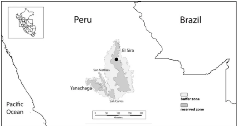
Figure 1. Location of study site (in black- see Fig. 2 for detail) and its position relative to the Yanachaga-San Carlos-San Matias-El Sira cordilleran complex.
In 2007 we initiated exploration of the isolated uplands of the El Sira Communal Reserve, focusing our efforts on its northern sector (see Figure 1). We chose this region in consideration of the fact that the highest peaks of the entire uplift are found here. Our point of
5
entry was along the Ucayali River (eastern) side of the cordillera.
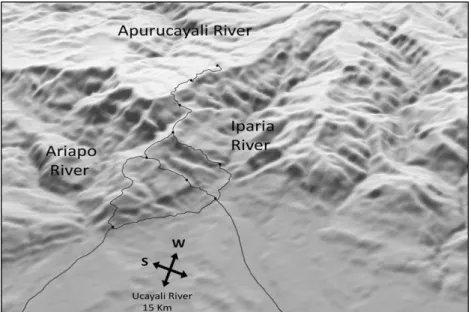
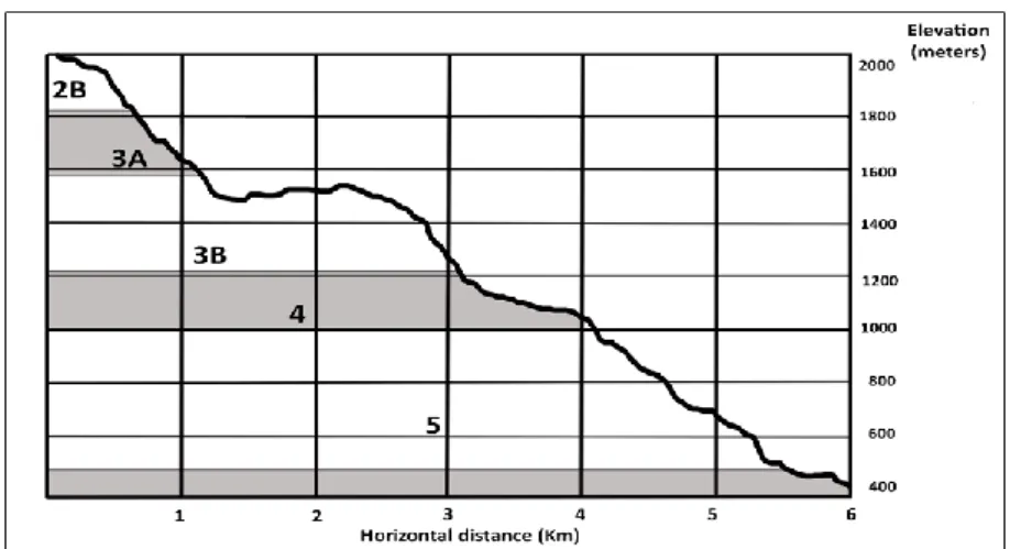
First clearing a trail system from the river to the base of the uplift, we established a base camp and conducted botanical exploration as we probed the steep eastern escarpment of the cordillera, seeking a manageable route to the upper elevation zones of the chain. Over several expeditions we established an elevational transect that passes through a diverse series of forests: from lowland Amazonian, climbing through premontane and transitional forest types, into pristine cloud forests and ultimately emerging into the unique elfin forest formations dominating the upper elevations in this section of the range (see Figure 7). Over the past decade we have continued to expand our trail system (see Figure 2), investigating a variety of abiotic factors in addition to making numerous botanical and zoological collections.
Our interdisciplinary exploration of the biota of the El Sira Communal Reserve has among its aims a deeper understanding of the unique elfin forest ecosystems of the eastern Andes, beginning with the approximately 20 Km2 area of elfin forest habitats found along the upper elevations of our transect. A related goal is the identification of critical elements driving the process of landscape self-organization across our study site, which presents a diverse ecological mosaic arrayed across a remarkably steep topography- climbing more than 1500 meters elevation in under 6 Km of linear distance- embracing a wide variety of microhabitats. These aims require documentation of physical constraints – rainfall, elevation, temperature, topography, geomorphology, soil chemistry, wind and insolation – articulated both within and between- multi-species assemblages scattered across a unique environmental gradient.
We feel that patterns of diversity and distribution of bryophytes – a ubiquitous component of cloud and elfin forests along our elevational transect – provide a useful approach toward realizing these goals. Species-level distributional data afford the opportunity to evaluate the community-level role of bryophytes within and between habitats, and to explore their influence on multi-trophic landscape-scale processes. At minimum, these data provide a census of the bryoflora of a previously-unstudied region, and can form a basis for a wider evaluation of regional-scale bryophyte biogeography. In order to better place these collections within the context of local landscapes, a brief overview of the study area is presented.
6
Plate I. Photo 1. View of the highlands of the El Sira Communal Reserve from the Ucayali River, looking west. Photo 2. View of herbaceous-dominated elfin forest habitat (1A) atop the Ariapo plateau, looking west. Gallery forest (2A) habitat visible in lower elevations in the lower left of photo. Photo 3. View of elfin forest habitat (1A) from atop the Ariapo plateau, looking north. Ucayali River and highland ridges visible in the background. Photo 4. View of elfin forest habitat (1A) atop the Ariapo plateau, showing cliff faces of the northern escarpment of the plateau, looking west. Photo 5. View of semi-woody elfin forest habitat atop the Ariapo plateau, looking eastward. Photo 6. View of interior of elfin forest (1B) habitat atop the Ariapo plateau.
7
Plate II. Photo 7. View of elfin forest habitat (2B) along the steep slopes of the Ariapo uplift.
Photo 8. View of open elfin forest formation on sand (2A) atop the Ariapo plateau. Photo 9.
View of campsite in upper cloud forest (3A) habitat on the Ariapo uplift. Photo 10. View of interior of elfin forest (2B) habitat on steep slopes of the Ariapo uplift. Photo 11. View of stream bed in gallery forest (2A) habitat in steep-sided stream valleys atop the Ariapo plateau.
Photo 12. View of lush bryophyte community at the base of waterfall in gallery forest (2A) habitat in steep-sided stream valleys atop the Ariapo plateau. Photo 13. View of the highest peaks of the Cordillera El Sira (ca. 2400 meters elevation) looking westward from herbaceous dominated elfin forest (1A) habitat atop the Ariapo plateau.
8
In lowland regions of eastern Peru, rivers often still serve as highways. Approaching our study area, travelling southward up the Ucayali River, at about 100 Km out from the city of Pucallpa, the uplift known locally as Cerro Ariapo comes into view (weather permitting). On a clear day it appears as a series of peaks rising steeply to the west of the river, but is actually the rim of a very large plateau emerging from behind a series of subordinate hills and ridges (Plate I, photo 1). The top of this “peak”, from the vantage- point of the river, is actually a near-continuous series of quartz- containing sandstone cliffs underlying a large undulating plateau on its northern (Iparia River) and eastern (Ariapo River) flanks.
Elevations here reach slightly above 2100 meters (Plate I, photos 2 and 3), but the plateau descends gently to the west before climbing again to reach the highest peaks of the chain (Plate II, photo 13), at over 2400 meters elevation, approximately 15 Km distant.
Leaving the river, and passing through one of several native communities located in the buffer zone of the El Sira Communal Reserve, our trail approaches the eastern (windward) slopes of the cordillera El Sira, between the Iparia and Ariapo Rivers, both affluents of the greater Ucayali River watershed in Ucayali Department. At its upper elevations, atop the Ariapo plateau, our trail crosses over into Pasco Department, skirting the headwaters of the Chinchihuani stream, an affluent of the Rio Apurucayali, an affluent of the greater Pichis/Pachitea River watershed.
At the outset of our exploration, gradual, but recognizable, discontinuities in vegetation type were observed as we extended the transect. When exploring routes to ascend the uplift, climbing steep slopes and rocky cliffs, along ridgelines when we could, at various times we stumbled into new and distinctive patches of forest.
Members of our team- local inhabitants of the villages of the buffer zone, at times visible far below on the Ucayali River floodplain- would reflect that we were entering a “new world” (otro mundo) on the mountainside. Not only vegetation, but animals and geologic features played a part in these reckonings. These natural landforms and distinct vegetation types informed our early characterization of what we referred to as “pisos” (floors) along our trails, and we could refer to them in numerical order, from bottom to top.
9
Figure 2. General landscape view of the study site, with trails and campsites illustrated.
MATERIALS AND METHODS
The liverwort collections presented here were made by J. G. Graham between 2007 and 2011 in the El Sira Communal Reserve, at elevations between 240 and 2100 meters. Both epiphyllous and other liverworts are represented. Sampling was limited mainly to the forest understory, up to about five meters in height (the maximum length of our pole pruners), and on fallen trees. Only in elfin forest formations could canopy sampling be routinely conducted. Collections were made at random, the main discriminating factors of our sampling being convenience (proximity to our trail and relative ease of access) and apparent diversity (perceptible difference from what had been previously sampled at a similar elevation). No statistically-validated sampling protocol was followed.
Specimens of non-epiphyllous bryophytes were shade-dried.
Epiphyllous liverworts were collected along with their host-plant leaves, which were then pressed and dried in the field. All liverwort specimens were processed by M. Fischer (F) and identified by T. Pócs (EGR). A number of critical genera (like Jungermannia, Plagiochila, Frullania) await further investigation by specialists, and only a
10
smaller part of their species is represented here. Duplicate specimens of all collections are deposited at Herbario Forestal (MOL), Universidad Nacional Agraria Molina, Lima, Peru and Field Museum (F). Duplicate specimens of many of the liverworts reported here were deposited in the Herbarium of Eszterházy Károly University, Eger, Hungary (EGR). The description of environmental conditions including landscape analysis was made by J. G. Graham, while the taxonomic and phytogeographical evaluation of liverwort records were made by T. Pócs.
Temperature data were collected using Thermochron DS1922L iButton data logging devices, rainfall data were collected using Stratus RG202 Long Term Professional Rain Gauges. Representative soil data come from exposed mineral soil profiles in excavated soil pits. Soil samples were shade dried and characterized at the Soils Laboratory of the Universidad Nacional Agraria La Molina, Lima, Peru. Vascular plant data were provided from collections made by J.
G. Graham.
RESULTS
Environmental gradients
Rainfall and temperature are probably the most important environmental factors in determination of vegetation zonation in tropical mountains (Frahm and Gradstein, 1991, Pócs 1977, 1994).
Along our transect, altitudinal changes in environmental conditions occurring over a relatively short geographical range contribute to subtle transformations in forest structure and species composition.
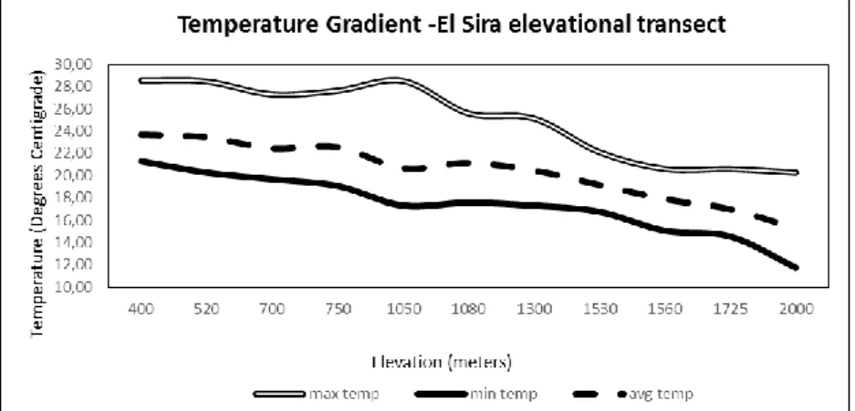
Environmental lapse rates along the transect have been measured to be around 5.3 °C/Km of altitude. These temperature changes affect evaporation, growth and decomposition rates, as well as a number of other biotic and abiotic functions.
Orography is the study of topographic relief of mountains, and orographic effects such as the interaction of the atmosphere with topography play a major role in defining the climate and habitat of our study area. The Cordillera El Sira, being the easternmost outlying range of the Andes in central Peru, as such receives some of the highest annual rainfalls recorded in the region. Prevailing easterly trade winds carry moisture from the Atlantic Ocean, along with abundant recycled moisture from the Amazon Basin. When this horizontally-flowing warm moist air mass encounters the cordillera,
11
it is forced upslope. As it ascends, this air expands and cools, allowing for condensation, cloud formation and precipitation.
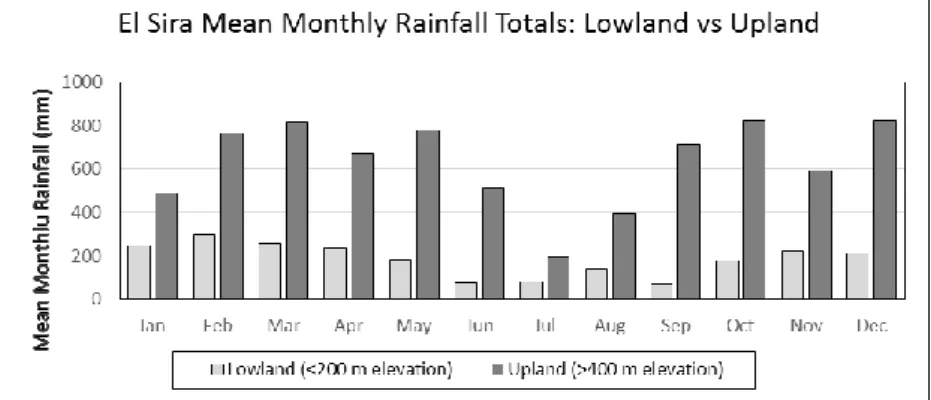
Seasonal climate in the highlands of our study area can be broadly characterized as having a ten month wet season, from September through June (mean rainfall > 400 mm/month) and a 2-month dry season from July through August. Annual rainfall totals in our study area tend to be evenly distributed across all elevations. While there are slight differences between the four elevations at which we monitor rainfall (1800, 1500, 1000 and 400 meters), especially in the drier months, when it rains heavily it tends to rain heavily at all locations fairly equally up and down the elevational gradient. In contrast to our rainfall data collected over 5 years in the El Sira uplands, locations only a short distance to the east of the uplift (5-10 Km) show about a fourfold reduction in mean monthly and annual rainfall totals (see Figure 3).
Cloud formation and immersion most certainly play a major role in microclimatic variation (Romanski 2007), and the relative contribution of cloud-water to the hydrological cycle in the upper elevations in our study area is estimated to be a critical, but as-yet unquantified factor. We anticipate the installation of cloud-catchers to better monitor this phenomenon, but only anecdotal information is available at present. Fog frequencies are certainly greatest above 1000 meters elevation along the transect.
Figure 3. Mean monthly Rainfall (mm) comparing El Sira uplands vs. adjacent lowlands.
The relative precipitative contribution (where wind-driven fog particles are precipitated onto vegetation on contact) appears to be
12
a fairly localized phenomenon, dependent on temperature and humidity as well as exposure to prevailing winds, among other factors. It appears that the most important zone of cloud immersion along the transect is a narrow ridge at about 1500 meters elevation that divides the Iparia from the Ariapo River watersheds. Wind- driven clouds forming in the Iparia lowlands are commonly observed ascending the steep (northern-facing) slope of the ridge, skimming over the ridgetop and descending into the Ariapo basin.
High epiphyte loads, bryophyte density and diversity are all found to occur here, despite the absence of a thick layer of poorly- decomposed organic material covering the soil (found at higher elevations) that serves as a readily-available surface for bryophyte colonization.
Mean annual temperatures along our elevational gradient vary at about one degree centigrade per 190 meters of elevation (between 400 and 2000 meters – see Figure 4). Once the transect reaches the top of the Ariapo plateau, which has relatively little altitudinal variation, temperatures are observed to vary only slightly, due primarily to habitat variation. Steep-sided canyons that cut across the plateau have lower mean temperatures, while mean temperatures measured on and below exposed cliff faces are slightly higher than what is predicted by elevation alone.
Figure 4. Temperature differentials measured along the slopes of our elevational transect in uplands of the El Sira Communal Reserve.
We initiated a series of soil plots along the transect, initially to try and identify factors that might explain divergent vegetation types
13
observed in the elfin forests found atop the Ariapo plateau. Plots were established along the transect, with measurement of woody vegetation surrounding each soil plot. To date we have established 27 soil plots. Of the 15 plots atop the plateau, 13 were on what was observed to be a heavy clay substrate of a variety of colors- brown to red to yellow to white- with three different vegetation types represented. Two plots were placed in narrow forested stream valleys transecting the plateau- these below sandstone cliffs contained coarse greyish sand soils. Five plots were located on the steep southeastern slopes of the uplift between 1900 and 1700 meters elevation. The upper two of these were of coarse greyish sand, the lower three were of mixed clay/sand. All of these (17) plots had a thick, spongy organic layer composed of mainly of fine roots of varying decomposition overlaying the mineral soil horizon.
Seven plots were established at elevations (from about 1600 meters) below where this organic layer disappears. One was established at about 1500 meters, consisting of what appeared to be dense, decomposed limestone, one was at about 1300 meters with heavy clay, one at 1100 meters with fine brown sand, two at 750 and 700 meters, both of dense yellowish clay, and one at about 500 meters, of fine reddish sand. One final soil plot was established in a unique low-elevation elfin forest formation at 1100 meters. This plot had a thick (25 cm) organic layer overlaying a mineral soil of dense reddish-brown clay.
From each soil-sampling site (one-meter-square at the surface- of varying depth) we sampled different soil horizons, measuring the thickness of leaf litter, of layers of undecomposed, moderately decomposed and finely decomposed organic material, as well as estimating the volume of rocks and/or large roots penetrating the organic layer and/or mineral soils.
Physical parameters noted in the field were elevation, slope, exposure, geographic coordinates and micro relief. In the plots with an organic layer overlaying the mineral soil horizon, we established a 100-meter-square area around the soil pit where woody vegetation was monitored, including number of stems, stem diameter at breast height (DBH), canopy height, and noting when horizontal trunks are present, as well as palms or tree ferns. In plots without an overlaying organic layer, we established 0.1 hectare plots, including number of stems, stem diameter at breast height (DBH) and individual tree height, including palms and tree ferns.
14
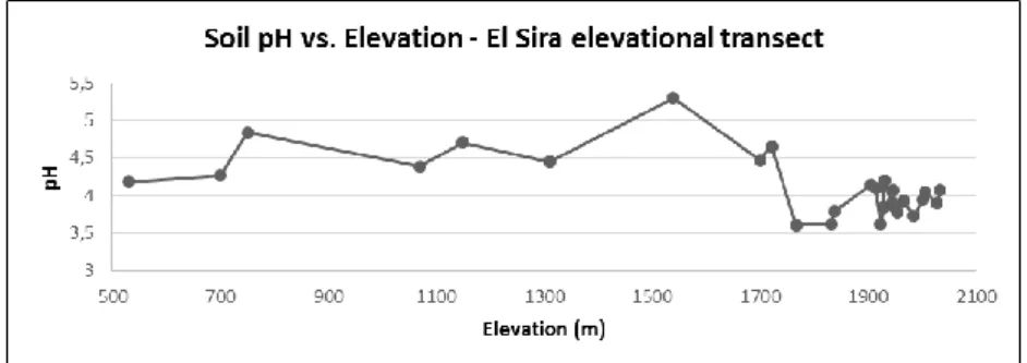
Figure 5. Soil pH as measured along our elevational transect in uplands of the El Sira Communal Reserve.
A number of soil physicochemical parameters, including pH, were characterized, and the assays revealed that the soils along the transect are remarkably acidic (see Figure 5). 74% of plots had soils characterized as extremely acidic (pH range 3.5–4.4), 22% were very strongly acidic (pH range 4.5–5), with 4% (a single plot) strongly acidic (pH 5.1–5.5).
Continuous abiotic data (temperature and elevation) corroborate much of our initial informal meso-scale recognition of landscape types, generally referred to by local indigenous assistants as pisos, or floors. The plot data- in particular the realization of two discontinuous soil types and the presence or absence of an organic layer capping the mineral soil present in the upper elevations of our transect - provided the data for further habitat sub classification.
Bryophytes are certainly not distributed uniformly across the elevational gradient of our study site. The addition of species-level floristic elements to our emergent habitat framework introduces another level of complexity, one that may allow further refinement of our concept of local landscape units. The following section will present our liverwort collections in this context, providing the raw data with which we can begin to explore relationships between these important biotic elements and their potential role in ecosystem organization.
15 Liverwort Collections
A total of 171 liverwort species are reported to date from our study site, from more than 600 collections, representing 16 families and 50 genera. These are presented in Table 1. It should be remembered that this list is only a fraction of the total bryophyte population at our study site, and that many important Neotropical liverwort families, as well as all the mosses, in our present collections are not represented here. Further botanical exploration is expected to expand the known distribution of liverwort species across the landscape, as well as introduce new species to our checklist. We look forward to further elucidation of patterns of bryophyte diversity and distribution, both across our transect as well as within the cis- Andean foreland of central Peru.
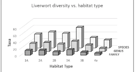
Table 1. List of liverwort species identified from bryophyte collections to date in our study area. Numbers in columns refer to number of species collected in a particular habitat, and letter x refers to the presence of epiphyllous taxa found in a given habitat. Habitat typification is as follows: Type 1 (with two subtypes) represents elfin forests on clay, type 2 (with two subtypes) represents elfin forests on sand, type 3 (with two subtypes) represents cloud forests, type 4 represents transitional forest, type 5 represents premontane forest, and type 6 represents lowland forest habitats. Please refer to the following section for further discussion of these habitat types.
Name 1
A 2 A 1
B 2 B 3
A 3
B 4 5 6 Adelanthaceae
Pseudomarsupidium decipiens (Hook.) Grolle 1 3 Adelanthus lindenbergianus (Lehm.) Mitt.. 1 Aneuraceae
Riccardia amazonica (Spruce) Schiffn. ex Gradst. 2
Riccardia digitiloba (Spruce ex Steph.) Pagán 1
Riccardia fucoidea (Sw.) Schiffn. 8 4 3 5 3 2
Riccardia glaziovii (Spruce) Meenks 2 3 1
Riccardia hymenophytoides (Spruce) Meenks 1 Riccardia poeppigiana (Lehm. & Lindenb.) Hässel & Meenks 1 Calypogeiaceae
Calypogeia lechleri (Steph.) Steph. 1
Calypogeia peruviana Nees & Mont. 1 2 2 4
Mnioloma caespitosum (Spruce) R.M.Schust. 1
Mnioloma cellulosum (Spreng.) R.M.Schust. 2 2 1 1 2
Mnioloma cyclostipum (Spruce) R.M.Schust. 3 1
Mnioloma fissistipulum (Bischl.) R.M.Schust. 1
Mnioloma venezuelanum (Fulf.) R.M.Schust. 2 2 1
Cephaloziaceae
Fuscocephaloziopsis crassifolia (Lindenb. & Gottsche)
Váňa & Söderstr. 1 1 1 1 2
Nowellia reedii Robins. 3
Odontoschisma longiflorum (Taylor) Trevis. 1
Odontoschisma cleefii Gradst., S.C. Aranda & Vanderp. 1
Odontoschisma variabile (Lindenb. & Gottsche) Trevis. 1 1 1
16
Name 1
A 2 A 1
B 2 B 3
A 3
B 4 5 6 Dumortieraceae
Dumortiera hirsuta (Sw.) Nees 1
Herbertaceae
Triandrophyllum subtrifidum (Hook.f. & Tayl.) Fulf. & Hatch. 1 Jamesoniellaceae
Syzygiella perfoliata (Sw.) Spruce 1
Syzygiella rubricaulis (Nees) Steph. 2 1 Jubulaceae
Jubula bogotensis Steph. 4
Frullaniaceae
Frullania bicornistipula Spruce 2
Frullania crispiloba Steph. x x
Frullania ecuadoriensis Steph. x x x
Frullania griffithiana Gottsche 1 1
Frullania meridana Steph. 1
Frullania mirabilis Jack & Steph. 1
Frullania macrocephala (Lehm. & Lindenb.) Lehm. & Lindenb. 1 Lejeuneaceae
Anoplolejeunea conferta (Meissn.) A. Evans 1
Bryopteris filicina (Sw.) Nees 1 1 4
Ceratolejeunea coarina (Gottsche) Steph. 1
Ceratolejeunea cornuta (Lindenb.) Schiffn. 3 1 3 1 x x x x Ceratolejeunea fallax (Lehm. & Lindenb.) Bonner 1
Ceratolejeunea grandiloba J.B. Jack & Steph. 1
Ceratolejeunea malleigera (Spruce) Steph. 1
Ceratolejeunea spinosa (Gottsche et al.) Steph. 1
Cheilolejeunea filiformis (Sw.) Ye et al. 2
Cheilolejeunea inflexa (Lehm.) Grolle 2 1 1 2 1
Cheilolejeunea sp. aff. Ch. papillata Solari 1
Cheilolejeunea trifaria (Reinw.& al.) Mizut. 1 1
Cololejeunea camillii (Lehm) A.Evans x x
Cololejeunea cardiocarpa (Mont.) A. Evans x
Cololejeunea erostrata (Herzog) Bernecker & Pócs x x
Cololejeunea gracilis (Ast) Pócs 1 2
Cololejeunea microscopica (Taylor) Schiffn. x
Cololejeunea obliqua (Nees & Mont.) Schiffn. x
Cololejeunea papilliloba (Steph.) Steph. 1
Cololejeunea papillosa (K.I.Goebel) Mizut. x x
Cololejeunea platyneura (Spruce) A.Evans x
Cololejeunea sicifolia ssp. jamaicensis (R.M. Schust.)
Bernecker & Pócs. 1
Cololejeunea winkleri (M.I.Morales & Bernecker) Pócs x
Colura greig-smithii Ast x x
Colura tortifolia (Nees & Mont.) Steph. x
Cyclolejeunea convexistipa (Lehm. & Lindenb.) A.Evans 1 1x x x Cyclolejeunea peruviana (Lehm. & Lindenb.) A.Evans x x x
Diplasiolejeunea brunnea Steph. x x
Diplasiolejeunea cavifolia Steph. x x x
Diplasiolejeunea caribea Tixier
Diplasiolejeunea inermis Tixier x x x x
Diplasiolejeunea johnsonii A. Evans x
Diplasiolejeunea pauckertii (Nees) Steph. x
Diplasiolejeunea pellucida (Meissn.) Schiffn. x x
Diplasiolejeunea sp. nov. 1
Diplasiolejeunea unidentata (Lehm. & Lindenb.) Schiffn. x x x
Drepanolejeunea anoplantha (Spruce) Steph. 1
Drepanolejeunea biocellata A.Evans x x
17
Name 1
A 2 A 1
B 2 B 3
A 3
B 4 5 6 Drepanolejeunea submuricata R.M. Schust 2 1 1 1
Drepanolejeunea inchoata (Meissn.) Schiffn. x
Drepanolejeunea infundibulata (Spruce) Steph. x x
Drepanolejeunea mosenii (Steph.) Bischler x
Drepanolejeunea trigonophylla Steph. x
Drepanolejeunea sp. nov. 1
Harpalejeunea cinchonae (Nees) Schiffn. x x
Harpalejeunea tridens (Besch. & Spruce) Steph. x x
Lejeunea adpressa Nees x x
Lejeunea sporadica Besch. & Spruce 1
Lejeunea flava (Sw.) Nees 2 x x
Lejeunea grossitexta (Steph.) M.E.Reiner & Goda 1 3
Lejeunea lusoria (Lindenb. & Gottsche) Steph. x
Lejeunea obtusangula Spruce 1
Lejeunea reflexistipula (Lehm. & Lindenb.) Lehm. & Lindenb. 1
Lejeunea subspathulata Spruce 1 1
Leptolejeunea maculata (Mitt.) Schiffn. x x x x
Leptolejeunea elliptica (Lehm. & Lindenb.) Schiffn. x x x
Lopholejeunea eulopha (Nees) Schiffn. 1 1
Microlejeunea bullata (Taylor) Steph. x x
Odontolejeunea lunulata (Weber) Schiffn. x
Prionolejeunea aemula (Gottsche) A.Evans 3 1 1 4 1 1
Prionolejeunea ampliretis Herzog 1
Prionolejeunea decora (Taylor) Steph. 1
Prionolejeunea denticulata (Weber) Schiffn. 1
Prionolejeunea mucronata (Sande Lac.) Steph. 1
Prionolejeunea muricatoserrulata (Spruce) Steph. 1 2
Prionolejeunea scaberula (Spruce) Steph. 1 Prionolejeunea trachyoides (Spruce) Steph. 1
Prionolejeunea sp. nov. 1 2
Stictolejeunea squamata (F. Weber) Schiffn. 2
Taxilejeunea serpyllifolioides (Raddi) D.P. Costa 1 1
Xylolejeunea crenata (Nees & Mont.) X.L.He & Grolle 1 Lepidoziaceae
Bazzania affinis (Lindenb. & Gottsche) Trevis. 1 2 6 17 1
Bazzania bidens (Nees) Trevis. 2 1
Bazzania canelensis (Steph.) Fulford 3 2 2
Bazzania chilensis (Steph.) Fulford 1
Bazzania cubensis (Gottsche) Pagán 1 1 1 2
Bazzania cuneistipula (Gottsche & Lindenb.) Trevis 1 1 1 1 Bazzania denticulata (Lindenb. & Gottsche) Trevis. 2 1 9 10 1
Bazzania diversicuspis Spruce 2
Bazzania falcata (Lindenb.) Trevis. 2
Bazzania hookeri (Lindenb.) Trevis. 3 8 1 4 2 5 5
Bazzania jamaicensis (Lehm. & Lindenb.) Trevis. 1 7 3 3
Bazzania latidens (Gottsche) Fulford 1
Bazzania longistipula (Nees) Trevis. 2 2 1
Bazzania pallidevirens (Steph.) Fulford 1 2 2
Bazzania peruviana (Nees) Trevis. 1
Bazzania phyllobola Spruce 3 2 5
Bazzania roraimensis (Steph.) Fulford 8 7 1 3 2 2
Bazzania serrata Fulford 1 2
Bazzania stolonifera (Sw.) Trevis. 1 2
Kurzia capillaris (Sw.) Grolle 2 2 1 4 1
Lepidozia macrocolea Spruce 1
Lepidozia cupressina (Sw.) Lindenb. 2 4
Lepidozia incurvata Lindenb. 5 1 1 4 1
18
Name 1
A 2 A 1
B 2 B 3
A 3
B 4 5 6
Lepidozia squarrosa Steph. 2
Lepidozia subdichotoma Spruce 8 2 3 6
Micropterygium parvistipulum Spruce 2
Micropterygium reimersianum Herzog 2 1
Micropterygium trachyphyllum Reimers 6 6 1
Mytilopsis albifrons Spruce 2
Telaranea diacantha (Mont.) J.J.Engel & G.L.Merr. 5 1 1 1
Telaranea nematodes (Austin) M.A.Howe 1 1 1
Telaranea sp. 1 1
Telaranea sp. 2 1
Zoopsidella integrifolia (Spruce) R.M.Schust. 1
Lophocoleaceae
Cryptolophocolea martiana (Nees) L. Söderstr. 4 10
Cryptolophocolea martiana var. perissodonta (Spruce)
Gradst. 1 3
Heteroscyphus marginatus (Steph.) Fulford 1
Leptoscyphus amphibolius (Nees ) Grolle 1
Leptoscyphus gibbosus (Taylor) Mitt. 1
Leptoscyphus hexagonus (Nees) Grolle 1 1
Leptoscyphus trapezioides (Mont.) L.Söderstr. 4 1 1 2
Lophocolea bidentata (L.) Dumort. 1
Lophocolea muricata (Lehm.) Nees 1
Lophocolea orbigniana Nees & Mont. 3 3
Metzgeriaceae
Metzgeria albinea Spruce 1 8 3 3
Metzgeria leptoneura Spruce 1 3 1
Pallaviciniaceae
Pallavicinia lyellii (Hook.) Gray 1 3
Symphyogyna brongniartii Mont. 2
Symphyogyna aspera Steph. 1
Plagiochilaceae
Plagiochila aerea Tayl. 1
Plagiochila cristata (Sw.) Lindenb. 1
Plagiochila deflexirama Taylor 1
Plagiochila disticha (Lehm.& Lindenb.) Lehm. 1 1
Plagiochila heterophylla Lindenb. & Lehm. 1
Plagiochila raddiana Lindenb. 1 1
Plagiochila rutilans Lindenb. 1
Plagiochila subplana Lindenb. 1
Plagiochila superba (Spreng.) Mont. & Nees 1
Radulaceae
Radula flaccida Lindenb. & Gottsche x
Radula gottscheana Taylor 3 1
Radula involvens Spruce 2 2
Radula episcia Spruce 1
Radula sonsonensis Steph. 1
Radula javanica Gottsche 1 1
Scapaniaceae
Scapania portoricensis Hampe & Gottsche 3 1 9 3 Trichocoleaceae
Leomitra flaccida Spruce 1 1 4 1 4
Trichocolea filicaulis Steph. 1
Trichocolea sprucei Steph. 1 1 5
19 Preliminary Habitat Typification 1. Elfin forests on clay
1A. Herbaceous-dominated vegetation type (1950-2100 meters elevation)
On the eastern end of the Ariapo plateau, large sections are devoid of woody vegetation, thus the term elfin forest becomes a bit of a misnomer. This sector might better be characterized as herbaceous-dominated with well-delineated pockets of elfin forest (Plate I, photos 2 and 5). Non-woody vascular vegetation here is dominated by the following families and genera- Poaceae (Neurolepis), Bromeliaceae (Pitcairnea, Guzmania, Racinaea), Orchidaceae (Epidendrum, Elleanthus, Pleurothallis), Pteridophyta (Blechnum, Cyathea), Asteraceae (Baccharis, Munnozia, Mikania), Gentianaceae (Macrocarpea, Symbolanthus), Alstroemeriaceae (Bomarea), Liliaceae (Excremis, Isidrogalvia), Eriocaulaceae (Paepalanthus, Syngonanthus) and Xyridaceae (Xyris).
Herbaceous-dominated vegetation types on clay soils were sampled at elevations between 1900 to 2050 meters. The plateau itself undulates quite steeply in places, but the altitudinal variation here is also due to the downward slope of the plateau to the westward in this sector. Vegetation at these sites was entirely herbaceous, with vegetation heights between 5 cm to 1.5 m. All soils were covered by a spongy layer of variously-decomposed material consisting mainly of fine roots, at depths that varied from 5 to 40 cm.
Soils on the poorest sites, vegetatively speaking, have a clear tendency toward waterlogging. Terrestrial lichens, Cyperaceae (Rhynchopylla, Oreobolus) and the insectivorous Drosera (Droseraceae) are found here, along with the previously- undescribed endemic Gentiana sirenis (Gentianaceae). Here, both vegetation height and thickness of organic layer are lowest.
Liverwort species (13 families, 24 genera and 41 species) found in this habitat to date include:
*Adelanthus lindenbergianus Bazzania bidens
Bazzania canelensis Bazzania cuneistipula
*Bazzania falcata Bazzania hookeri Bazzania longistipula Bazzania roraimensis Bazzania stolonifera
Lepidozia incurvata Lepidozia subdichotoma Leptoscyphus hexagonus Metzgeria albinea Metzgeria leptoneura Mnioloma cellulosum
*Odontoschisma cleefii Odontoschisma variabile Prionolejaeunea aemula
20
Calypogeia peruviana Ceratolejeunea cornuta
*Ceratolejeunea grandiloba Cheilolejeunea inflexa
*Cheilolejeunea cf. papillata
*Drepanolejeunea sp. nov.
Drepanolejeunea submuricata
*Frullania mirabilis
Fuscocephaloziopsis crassifolia Kurzia capillaris
Lejeunea grossitexta Leomitra flaccida
*Prionolejeunea scaberula Pseudomarsupidium decipiens Radula involvens
Riccardia fucoidea Riccardia glaziovii
*Riccardia hymenophytoides Scapania portoricensis Syzygiella rubricalus Telaranea diacantha Telaranea nematodes Trichocolea sprucei
*Indicates species found only in this habitat (22% of species identified from this habitat). Boldface indicates new distribution record for Peru (27% of species identified from this habitat).
Where slopes are steepest, sections of vegetation and their underlying layer of variably-decomposed organic material can slip, revealing the bare clay slope beneath. On sites like these, lichens and mosses are typically the first colonizers of the acid clay soils, followed by Orchidaceae, Bromeliaceae and Cyperaceae.
This broad herbaceous-dominated background is broken up- especially on sites that are not as prone to water-logging, with mixed herbaceous and small-stature (0.5–1.5 m) woody vegetation. Woody or semi-woody plants commonly encountered intermixed with herbaceous vegetation include Rubiaceae (Notopleura), Ericaceae (Bejaria, Disterigma), Asteraceae (Baccharis), Clusiaceae (Clusia), Myrsinaceae (Myrsine) and Polygalaceae (Monnina). Thickness of organic layer capping the soil here has been measured from 50-60 cm, with woody vegetation height up to 2 meters.
On sites with some level of wind-protection, distinct patches of elfin forest with stunted (2-4 meters in height) trees emerge. The majority of bryophytes we encountered in this mixed herbaceous- dominated vegetation were found as epiphytes on woody vegetation, or on the organic layers under the forest canopy. We found liverwort to moss ratios here to be nearly seven to one.
Elfin forest patches in this sector appear from a distance to be relatively homogenous in stature, but on closer inspection the vegetation generally diminishes toward the edge of each patch.
Common tree families here include extremely hard-wooded trees, represented by Theaceae, Symplocaceae, Sabiaceae, Myrtaceae,
21
Melastomataceae, Lauraceae, Annonaceae and Podocarpaceae families, intermixed with smaller tree ferns, Schefflera (Araliaceae), Hedyosmum (Chloranthaceae) shrubs, and Geonoma palms. Mean thickness of the organic layer capping the soil here is slightly above 40 cm. A weak trend toward thinner organic layers with higher stem densities appear in the plot data. Mean canopy height is about 4 meters (Plate I, photo 4).
1B. Forest-dominated vegetation type (1850-2000 meters elevation)
Further west (2-3 Km) on the plateau, herbaceous-dominated sectors of vegetation rapidly disappear, becoming a mosaic of near- continuous woodland interspersed with sections of herbaceous- dominated vegetation (Plate I, photo 6). Tree heights here are slightly higher than those in the forest patches noted in the herbaceous-dominated vegetation, but never exceed 5 meters, with the exception of the palm Dictyocaryum lamarckianum, which can reach up to 7 meters on occasion, emerging above the surrounding canopy to punctuate the skyline.
Species densities can be quite high here- nearly monodominant patches of Geonoma palms, with a thick understory of Bromeliads, Clusia patches, apparently all the same species, up to about two meters in height, along with large patches of the black-bearded Euterpe caatinga palm up to five meters in height are found. Apart from these monodominant patches, the forest matrix itself is also characterized by overall high species densities, with species turnover changing dramatically at the kilometer scale. These elfin forests exhibit a low level of alpha diversity, but a high level of compositional unpredictability, contributing to overall high diversities at the meso-scale. Liverwort species (9 families, 19 genera and 28 species) found in this habitat to date include:
Bazzania canelensis Bazzania cubensis Bazzania denticulata Bazzania hookeri Bazzania longistipula Bazzania roraimensis Cheilolejeunea inflexa
*Cololejeunea microscopica
*Diplasiolejeunea pauckertii Drepanolejeunea submuricata
*Frullania meridana
Lepidozia incurvata Lepidozia subdichotoma Leptoscyphus hexagonus Leptoscyphus trapezioides Lophocolea orbigniana Metzgeria albinea
*Mytilopsis albifrons Odontoschisma variabile Prionolejeunea aemula Riccardia fucoidea Riccardia glaziovii
22
Fuscocephaloziopsis crassifolia Kurzia capillaris
Leomitra flaccida
*Syzygiella perfoliata Telaranea diacantha Telaranea nematodes
*Indicates species found only in this habitat (18% of species identified from this habitat). Boldface indicates new distribution record for Peru (25% of species identified from this habitat).
It should be mentioned here that this habitat type, being located at the outermost section of the transect, has not been as extensively explored as sectors of the transect closer to the river.
2. Elfin Forests on sand
2A. Gallery-forest (1800-1900 meters elevation)
Atop the plateau, where the clay soils have been eroded, the underlying quartz-containing sandstone is revealed. Low basins at the base of steep slopes (Plate II, Photo 8), as well as very narrow stream valleys (Plate II, Photo 11) closely surrounded by steep sandstone cliffs are underlain by a coarse sand substrate.
Tree stature here, in the valleys, on sand, is generally higher than that of adjacent forests on clay. (Mean canopy height is 5.5 m). These gallery forests are protected from the heaviest winds, and due to low water retention on sand, are not prone to waterlogging as are those on the clay soils of the plateau above. In these steep valleys, insolation is lower, humidity is higher, and temperatures are steadier, but lower in the mean than at surrounding plots. Epiphyte volume- dominated by bryophytes - is quite high here (Plate II, Photo 12). Mean thickness of organic layer capping the soil is about 40 cm.
Interestingly, the presence of standing dead wood (of any appreciable size) is almost nonexistent anywhere on the plateau or in the gallery forests. Any fallen wood (and horizontal trunks) in these gallery forests become rapidly covered by a thick layer of bryophytes and understory plants. In narrow valley bottoms surrounded by steep sandstone cliffs we have found quite a number of well-preserved trunks of very dense wood, recovering them from out of the thick (up to 80 cm) organic layers overlaying the sand.
Liverwort species (15 families, 28 genera and 51 species) found in gallery forest on sand substrate to date include:
Bazzania cuneistipula Bazzania denticulata Bazzania hookeri Bazzania jamaicensis
Lopholejeunea eulopha Metzgeria albinea
Micropterygium reimersianum Mnioloma cellulosum
23
*Bazzania latidens Bazzania roraimensis Ceratolejeunea cornuta Cheilolejeunea inflexa Diplasiolejeunea cavifolia
*Diplasiolejeunea replicata Drepanolejeunea submuricata
*Frullania bicornistipula Fuscocephaloziopsis crassifolia Kurzia capillaris
Lejeunea grossitexta
*Lejeunea reflexistipula Lejeunea subspathulata Leomitra flaccida Lepidozia incurvata Lepidozia subdichotoma
*Leptoscyphus gibbosus Leptoscyphus trapezioides Lophocolea orbigniana Lopholejeunea eulopha Metzgeria albinea
*Mnioloma fissistipulum
*Nowellia reedii Prionolejeunea aemula
*Prionolejeunea decora Prionolejeunea muricatoserrulata
*Prionolejeunea sp. nov.
*Prionolejeunea trachyodes Pseudomarsupidium decipiens Radula involvens
*Radula sonsonensis Riccardia fucoidea Riccardia glaziovii
*Riccardia poeppigiana Scapania portoricensis
*Symphyogyna brongniartii Syzygiella rubricaulis Telaranea diacantha
*Triandrophyllum subtrifidum
*Trichocolea filicaulis Trichocolea sprucei
*Indicates species found only in this habitat (33% of species identified from this habitat). Boldface indicates new distribution record for Peru (33% of species identified from this habitat).
2B. Steep slopes (1850-2000 meters elevation)
These elfin forests are found entirely downslope from the emergent sandstone cliffs underlying the summit of the Ariapo plateau. The sandy soils found here are eroded entirely from these cliffs. Mean thickness of the organic layer capping the soils here is about 28 cm.
Mean canopy height is estimated at 7 meters (Plate II, photos 7, 10).
Within approximately 250 meters horizontal distance and 150 meters vertical distance from the cliff base, mixed clay/sand soils abruptly replace the pure sand substrate that represents the limit of elfin forest habitat on these steep slopes. On the slopes below this abrupt soil substrate turnover, epiphyte densities are substantially reduced and tree heights increase. Liverwort species (10 families, 22 genera and 44 species represented) found in this habitat to date include:
Bazzania affinis Bazzania bidens Bazzania canelensis Bazzania denticulata Bazzania hookeri
Lepidozia incurvata
*Lepidozia macrocolea
*Lepidozia squarrosa Lepidozia subdichotoma Leptoscyphus trapezioides
24
Bazzania pallidevirens
*Bazzania peruviana Bazzania phyllobola Bazzania roraimensis Bazzania serrata Calypogeia peruviana Ceratolejeunea cornuta
*Cheilolejeunea filiformis Cheilolejeunea inflexa Cyclolejeunea convexistipa Drepanolejeunea submuricata Frullania griffithiana Fuscocephaloziopsis crassifolia Kurzia capillaris
Lejeunea subspathulata Leomitra flaccida Lepidozia cupressina
Lopholejeunea eulopha Metzgeria albinea Metzgeria leptoneura
*Micropterygium parvistipulum
*Mnioloma caespitosum Mnioloma cyclostipum Mnioloma venezuelanum Odontoschisma variabile Prionolejaeunea aemula
*Prionolejeunea ampliretis
*Prionolejeunea sp.nov.
*Riccardia amazonica Riccardia fucoidea Scapania portoricensis Trichocolea sprucei
*Indicates species found only in this habitat (21% of species identified from this habitat). Boldface indicates new distribution record for Peru (29% of species identified from this habitat).
3. Cloud Forest
In the previous section we mentioned the relatively abrupt division found between the cliff-derived coarse sandy soils deposited from above, and the variable loamy clay and sand soil mixtures found downslope. This division of soils represents a break between what we characterize as elfin and cloud forest habitats, occurring in our area at about 1850 meters elevation. Along the steep slopes approaching the Ariapo plateau from the Iparia River valley, tree canopy heights are seen to decrease upslope (see Figure 6), reaching an inflection point at this ecotone.
Upper and lower cloud forest are terms of reference we use to distinguish between two easily-identifiable forest types: those with, and those without, a dense but spongy layer of variably-decomposed fine roots overlaying the soil surface. The presence of this layer is diagnostic of what we define as upper cloud forest. Its thickness decreases with altitude until it eventually disappears, at which point lower cloud forest begins. The lower limit of cloud forest we define based on a combination of epiphyte content, the existence of Andean floral (and faunal) elements, and the frequent occurrence of a conspicuous layer of dense, moisture-laden fog moving through the forest. Along the transect, the lower limits of lower cloud forest are
25
found at about 1250 meters, while those of the upper cloud forest begin around 1600 meters.
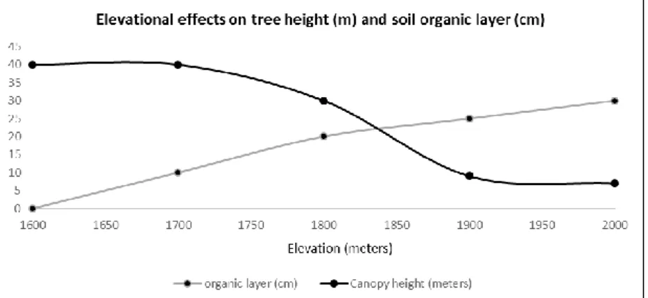
Figure 6. Elevational effects on mean tree canopy height (m) and soil organic layer (cm) between upper cloud forest and elfin forest formations on the steep slopes of the Ariapo uplift.
3A. Upper cloud forest (1850-1950 meters elevation)
The upper cloud forest zone along the transect is, among other emergent landscape elements, characterized by the presence of a persistent organic layer overlaying the soil, and abundant epiphytic vegetation, including bryophytes, pteridophytes, Orchidaceae, Bromeliaceae, Araceae, Piperaceae and a few notable woody epiphytes including Cybianthus magnus (Myrsinaceae).
Understory vegetation here is dominated by single-stemmed Wettinia and Geonoma palms, tree ferns, scandent Cyatheaceae, shrubby Rubiaceae (Palicourea, Psychotria), abundant viny Ericaceae, and terrestrial Araceae, Gesneriaceae (Columnea, Besleria) and Alstroemeriaceae (Bomarea). Sprawling thickets of the wiry bambusoid grass Chusquea increase with elevation.
Mean canopy height here is about 40 meters, while the thickness of the organic layer overlaying the mineral soil decreases with elevation- mean thicknesses measuring about 20 cm. at 1850 meters elevation, becoming gradually reduced in thickness until the organic layer disappears entirely from the soil at about 1600 meters. Large palms, including the rare Wellfia alfredii and tall Dictyocaryum lamarckianum are quite characteristic of this habitat type, dominating the canopy along with Melastomataceae (Miconia) and Clusiaceae (Clusia), Lauraceae (Nectandra, Bielschmiedia), and an
26
interesting Central American disjunct (Croizatia) in the Euphorbiaceae found to be quite common in this habitat (Plate II, photo 9 and Plate III, photos 15, 16). Liverwort species (15 families, 33 genera and 66 species represented) found in upper cloud forest habitat to date include:
*Anoplolejeunea conferta Bazzania affinis
*Bazzania chilensis Bazzania cubensis Bazzania cuneistipula Bazzania denticulata Bazzania hookeri Bazzania jamaicensis Bazzania phyllobola Bazzania roraimensis Bryopteris filicina
*Calypogeia lechleri Calypogeia peruviana
*Ceratolejeunea coarina Ceratolejeunea cornuta
*Ceratolejeunea fallax
*Ceratolejeunea malleigera
*Ceratolejeunea spinosa Cheilolejeunea trifaria Cryptolophocolea martiana Cryptolophocolea martiana var.
perissodonta
Cyclolejeunea convexistipa Cyclolejeunea peruviana Diplasiolejeunea cavifolia Diplasiolejeunea inermis
*Drepanolejeunea anoplantha Prionolejeunea aemula
*Prionolejeunea denticulata Radula gottscheana Radula javanica
*Riccardia digitiloba Riccardia fucoidea Scapania portoricensis
*Dumortiera hirsuta Frullania crispiloba Frullania ecuadoriensis
Frullania griffithiana Fuscocephaloziopsis crassifolia
*Jubula bogotensis Kurzia capillaris
*Lejeunea sporadica Leomitra flaccida Leptoscyphus trapezioides
*Lophocolea bidentata
*Lophocolea muricata Metzgeria leptoneura
Micropterygium trachyphyllum Mnioloma cellulosum
Mnioloma venezuelanum
*Odontoschisma longiflorum Pallavicinia lyellii
*Plagiochila aerea
*Plagiochila cristata
*Plagiochila deflexirama Plagiochila disticha
*Plagiochila heterophylla Plagiochila raddiana
*Plagiochila rutilans
*Plagiochila subplana
*Plagiochila superba Prionolejeunea aemula
*Prionolejeunea denticulata Radula gottscheana Radula javanica
*Riccardia digitiloba Riccardia fucoidea Scapania portoricensis
*Stictolejeunea squamata Taxilejeunea serpyllifolioides Telaranea nematodes
*Telaranea sp. 1
*Telaranea sp. 2
*Xylolejeunea crenata
*Indicates species found only in this habitat (39% of species identified from this habitat). Boldface indicates a new species distribution record for Peru (17% of
species identified from this habitat).
27
Plate III. Photo 14. View of the Ariapo uplift to the south, from near basecamp along the Iparia River. Photo 15. View of interior of lower cloud forest (3B) habitat, on the steep slopes of the Ariapo uplift. Photo 16. View of interior of cloud forest at the ecotone (transition) between upper (3A) and lower (3B) cloud forest habitats.
Photo 17. View of lower cloud forest (3B) habitat descending to the south (Ariapo River drainage) from along narrow ridgetop.
28
Plate IV. Photo 18. View of interior of lower cloud forest (3B) habitat, showing characteristic Wettinia augusta palm understory. Photo 19. View of canopy of lower cloud forest (3B) habitat. Woolly monkey visible in center of photo. Photo 20. View of epiphyllous liverworts on flowering cactus cladode, transitional forest (4) habitat. Photo 21. View of interior of transitional forest (4) habitat.