Exposure matters: forest dynamics reveal an early Holocene conifer refugium on a north facing slope in CE
Europe
Pató, Zsuzsanna Anna1, 2.; Standovár, Tibor1, Gałka, Mariusz3; Jakab, Gusztáv4, 5; Molnár, Mihály.2, Szmorad, Ferenc6, Magyari Enikő2,6,7
1Eötvös Loránd University, Department of Plant Systematics, Ecology and Theoretical Biology, H-1117, Budapest, Pázmány Péter stny. 1/c., Hungary; patozsu@caesar.elte.hu
2Isotope Climatology and Environmental Research Centre (ICER), Institute for Nuclear Research, Hungarian Academy of Science, H-4026, Debrecen, Bem tér 18/c, Hungary;
3University of Lodz, Faculty of Biology and Environmental Protection, Department of Geobotany and Plant Ecology, 90-237 Lodz, Poland;
4Szent István University, Faculty of Agricultural and Economics Science, Szarvas, Hungary;
5Hungarian Academy of Science, Research Centre for the Humanities, Institute of Archaeology, Budapest, Hungary;
6Eötvös Loránd University, Department of Environmental and Landscape Geography, H-1117, Budapest, Pázmány Péter stny. 1/c., Hungary;
7MTA-MTM-ELTE Research Group for Palaeontology, H-1083 Budapest Ludovika tér 2, Hungary
Abstract
Although several studies provide a broad overview of vegetation changes in the Carpathian Basin during the Holocene, stand-scale vegetation changes are lesser known because of the rarity of suitable sampling sites. In this study we investigated the sediment of a small closed-canopy site (Nagy-forrás forest hollow, 685 m a.s.l., 0.1 ha), located in the Mátra Mountains, on the north facing slope of Kékes (1014 m a.s.l.). We carried out detailed pollen, conifer stomata and plant macrofossil analyses, as well as radiocarbon dating to examine Late Glacial and Holocene dynamics of vegetation development.
The site dates back to ca. 15 500 cal yr BP, when open boreal forests and wet tundra-like habitats occurred around the hollow. Closed forest cover developed around 14 600 cal yr BP, when a boreal European larch-Swiss stone pine (Larix decidua-Pinus cembra) forest surrounded the hollow. This vegetation type remained stable up to 7700 cal yr BP. We observed a hiatus between 7700 and 2710 cal yr BP, followed by a beech (Fagus sylvatica) dominated mixed temperate deciduous forest. Our results confirmed that the area was covered by a primary forest, as human influence was visible only from 175 cal yr BP. The relatively long lasting persistence of Pinus cembra in the Holocene at relatively low altitude was documented, which has never been found in Holocene sediments in the Pre- Carpathians before. We hypothesize that the north facing slope acted as a cold-stage refugium in the Early Holocene and could play the same role for the present-day beech forest that is threatened by recent climate change.
2
4
6 8 10 12 14
16
18
20
22
24
26
28
30
32
Keywords:North Hungarian Mountains, plant macrofossil, forest hollow, beech expansion, Pinus cembra, Larix decidua
Introduction
The last major climatic shift, the Pleistocene/Holocene transition that took place around 11 700 years ago is an intensively studied time period, partially because it gives us a better understanding of the ongoing climate change and its potential consequences. The effects of warming climate on ecosystem functioning, and particularly on vegetation dynamics are important fields of paleoenvironmental studies, because they directly influence our economy and civilization to a great extent (Elias, 2007;
Willis et al., 2007, 2010). Information about past rapid ecosystem reorganizations and their effects on human societies provide us useful lessons as to what mitigation measures should be done regarding ongoing climate change (Petit et al., 2008; Willis et al., 2007). They also help us designating the potential directions of habitat-targeted nature conservation (Birks, 1996; Jackson and Hobbs, 2009;
Lindbladh et al., 2007).
If we turn our attention to past vegetation changes and look at paleoecological studies, most of them describe vegetation dynamics on a regional scale due to the routinely used main proxy method pollen analysis (Birks and Birks, 2000, 2006) and basin size (> 5 ha, see in Bradshaw, 2007; Elias, 2007) that will result in regional vegetation reconstructions. Even though such studies are unquestionably important, the detection of local, i.e. population-level changes is also necessary to understand how climate change affects different microhabitats. Such knowledge about the stand-scale vegetation is particularly instructive for conservation planning (Birks, 1996; Jackson and Hobbs, 2009; Lindbladh et al., 2007) and forest management (Jasinski and Angelstam, 2002). Local information not only helps us to assess what factors threaten populations and what could be the potential vegetation response in general (Jackson and Sax, 2010), but it may also help us identifying places where a species can survive the otherwise unfavourable climatic conditions (Dobrowski, 2011; Gavin et al., 2014; Suggitt et al., 2011, 2018). These places serve as refugia (Birks and Willis, 2008); they can either be relatively large and continuous, or smaller, hosting isolated populations (Gavin et al., 2014; Stewart et al., 2010).
Such areas are immensely important, as they provide sources for recolonization (Väliranta et al., 2011) . For example, the spread of deciduous trees after the Last Glacial Maximum (LGM) was suggested to be facilitated by cryptic refugial populations (Birks and Willis, 2008; Provan and Bennett, 2008).
Refugia also have a key role in preserving the genetic diversity of a species (Höhn et al., 2009; Stewart et al., 2010; Svenning et al., 2008).
Local scale (2-10 km2) vegetation history data can be obtained, among others, by studying macrofossils from lake and peatland sediments (Birks, 1996, 2003), and also by studying the pollen composition of small sites under closed canopy, so-called ‘forest hollows’ (Bradshaw, 1988, 2007;
34
36
38
40
42
44
46
48
50
52
54
56
58
60
62
64
66
Overballe-Petersen and Bradshaw, 2011). Local-scale pollen studies (stand-scale palynology) require closed-canopy sites with accumulated dry sediments (e.g. mor humus) or special natural water bodies (‘forest hollows’) of 10-100 m diameter without in- and outflow (Bradshaw, 1988, 2007; Overballe- Petersen and Bradshaw, 2011). Under these circumstances the plant remains (including macrofossils and pollen) are mostly transported into the sediment under the canopy from 20-150 m distance (Calcote, 1995; Parshall and Calcote, 2001). In the last few decades, stand-scale studies were successfully used to investigate the forest development and long-term forest dynamics in Western and Northern Europe (Clear et al., 2015; Overballe-Petersen et al., 2013, 2014; Parshall, 1999) and in Central Europe (Hájková et al., 2015; Jamrichová et al., 2013; Novák et al., 2019).
Macrofossil analysis has been long used to complement pollen analysis by tracking local vegetation changes (Birks and Birks, 1975). Furthermore, plant macrofossils (e.g. fruits, seeds, bud scales, leaves) can be identified with a better taxonomic resolution than pollen grains, and many of them also represent species that produce low amount of pollen and would otherwise go unnoticed in the pollen record (Birks, 2007; Birks and Birks, 1975, 2000). Detailed macrofossil analyses were successfully used to track, among others, the paleohydrological and temperature changes during the postglacial period and geochemical conditions of wetland ecosystems (Gałka et al., 2017; Jakab and Sümegi, 2005; Magyari et al., 2001), forest development and dynamics (Birks, 2003; Jankovská, 1988;
Kołaczek et al., 2017) and tree- and timberline changes (Birks and Willis, 2008; Feurdean et al., 2016;
Magyari et al., 2018; Orbán et al., 2018)
In the neighbouring area of our study site, local vegetation development was studied mostly in higher mountainous areas, like the Precarpathian Hills and the Carpathian Mountains (Feurdean et al., 2013;
Gałka et al., 2017, 2018). At lower altitudes (< 750 m a.s.l.) of the Carpathian Basin, only few stand- scale studies were carried out so far (Hájková et al., 2015; Jamrichová et al., 2017). The main reason for this is the rarity of suitable sites due the arid, continental summers and recently the high density of wild game (biodisturbance) that disfavour mor humus accumulation and the long-term persistence of undisturbed forest hollows.
Regional vegetation historical studies (Buczkó et al., 2009; Feurdean et al., 2014; Magyari, 2015) suggest that the Carpathian Region served as refugium for many species in different areas. Several deciduous tree species had small populations (cryptic refugia) during the LGM (Provan and Bennett, 2008), which became important sources of recolonization (Birks and Willis, 2008; Magri, 2008; Willis et al., 2000). The vegetation of the Pannonian Basin reflects this historically large diversity in different floristic elements: several glacial relict species, Atlantic, Montane, Mediterranean and Steppe elements are present today (Fekete et al., 2014).
In this study, we present the results of a stand-scale paleoecological study that we undertook on the deposits taken at a small forest hollow (a spring-fed fen next to Nagy-Forrás) in the Mátra Mountains. These mountains are part of the North Hungarian Mountains, a separate geomorphological unit of the Western Carpathians. Since the site is located in close proximity of the Kékes Forest 68
70
72
74
76
78
80
82
84
86
88
90
92
94
96
98
100
102
Reserve, our study has a high nature conservation relevance as it sheds light on the vegetation history of one of the last primary forests in Hungary (Czájlik, 2009) and also in Europe (Sabatini et al., 2018).
To our knowledge, our research is the first stand-scale paleoecological study in Hungary.
The aims of this study are: i) to reconstruct stand-scale vegetation changes and succession over the Late Glacial and Holocene period; ii) to compare the local vegetation changes with regional trends, and to identify potential Late Glacial refugia for cold tolerant vegetation iii) to specify when the present-day beech dominated forest was formed and iv) to identify the first signs of human impact.
Materials and Methods
The locations of the potential forest hollows in the North Hungarian Mountains were collected using the geomorphological literature, the maps of the area and information given by the rangers of the Bükk National Park Directorate. Altogether 61 potential forest hollows were identified, from these 41 were visited and evaluated as a potential coring site. The vast majority of these places were disturbed by game and/or did not accumulate enough sediment. Altogether five sites were identified with undisturbed thick sediment layer and therefore suitable for multi-proxy paleoecological analyses. All of them are located in the Mátra Mountains and are landslide basins (Szabó, 1992, 1993; Szabó and Félegyházi, 1997). This study focuses on the paleoecological study of the site called Nagy-forrás forest hollow.
Regional setting
The Mátra Mountains (Figure 1) is one of the highest mountain ranges in Hungary, with the highest peak of the country (Kékes, 1014 m a.s.l.). The climate of the region is continental temperate (Standovár et al., 2017) with a mean annual temperature of 5.7 °C, while the mean monthly temperature is 15.5 ºC in July and -4.4 ºC in January (Ódor, 2000). The annual precipitation is 784 mm at the Kékes meteorological station, the number of snow covered days is 112 (Ódor, 2000). The area of the Mátra Mountains is mostly covered by deciduous forests and partly (12 178 ha) protected since 1985 (Mátra Landscape Protection Area).
104
106
108
110
112
114
116
118
120
122
124
126
128
Fig. 1. Location of Nagy-forrás forest hollow in the Carpathian Basin and in the Mátra Mountains.
The Mátra Mountains have been populated for several millennia: the first signs of human presence date back to the Upper Paleolithic ( Blattshaber-Blattspitzen complex, unknown dates , see in Bíró, 1984; Gutay, 2016). Permanent settlements were found on the lower slopes from the Late Neolithic (Linear Pottery Culture 5600-4500 cal yr BC, see in Domboróczki et al., 2016), while hillforts (Supplementary Figure 1) were built on several peaks during the Bronze Age (Füzesabony Culture 1700-1300 cal yr BC in Hungary, Kyjatice Culture 1100-700 cal yr BC in Hungary, see in Dénes and Nováki, 2010; Metzner-Nebelsick, 2012). Several towns and villages were established in the foothills during the Middle Ages (Fodor, 2010). The intensive use of the forests started only after AD 1708, when glasswork and potash production manufactures were established in the villages of the northern foothills. Despite the long history of human occupation in the region, the inner part of Mátra Mountains remained relatively undisturbed throughout prehistoric times and also during historical times due the relatively long distance from the foothills and the steep slopes (Czájlik, 2009).
130
132
134
136
138
140
Our study site lies on the northern slope of Kékes Peak that is dominated by submontane beech forests (Melittio-Fagetum, Soó 1964) and montane beech forests (Aconito-Fagetum) with patches of scree forests (Mercuriali-Tilietum) and mixed maple-ash-lime forests (Parietario-Aceretum). In the much lower (northern) parts of the slope, Norway spruce (Picea abies) and Scots pine (Pinus sylvestris) plantations occur (Vojtkó et al., 2010). The bedrock is andesite that is covered by shallowlessivated brown forest soils (Dávid, 1992; Láng et al., 2013). The slope above our coring site is covered by the last primary forests of Hungary, and therefore it is a well-studied and strictly protected area (Kékes Forest Reserve, see in Czájlik, 2009; Standovár et al., 2017). The area below our site has been heavily impacted by human activities: the first evidence of clearings dates back to AD 1856 (see Supplementary Figure 1), when a ca. 2 ha meadow appeared around Lake Pisztrángos (Biszak et al., 2014; Tímár et al., 2010). More extended deforestation started only after 1945, while an asphalt road was built in 1949 (Czájlik, 2009). Nowadays this part is covered by middle-aged (94 years old) beech forest mixed with silver birch (Betula pendula) and planted Norway spruce trees. These forests are managed for timber production by forestry; the last intervention was 25 years ago.
The studied site, Nagy-forrás forest hollow (Figure 1) is located between Lake Pisztrángos and the Kékes Forest Reserve (47°52'48.8"N 20°00'44.3"E, 685 m a.s.l.). It is located in a small depression which was most probably formed by a landslide (Szabó, 1992; Szabó and Félegyházi, 1997), and filled up slowly with sediment. Its extent according to our measurements is 25 x 50 m (ca. 980 m2) and today it is covered by the forest community of Carici remotae-Fraxinetum (Vojtkó et al., 2010). The canopy is characterized by common ash (Fraxinus excelsior), European aspen (Populus tremula), European beech (Fagus sylvatica) and black alder (Alnus glutinosa); canopy closure is around 50%.
The herb layer covers the entire surface; the dominant species are Carex remota and Athyrium filix- femina (70-70%). Abundant species are Solanum dulcamara (20%), Chrysosplenium alternifolium (15%), Circaea lutetiana (10%) and Impatiens noli-tangere (10%). Lycopus europaeus (5%), Eupatorium cannabinum (3%), Ranunculus repens (3%), Lysimachia nummularia (3%), Galium palustre (2%), Oxalis acetosella (2%), Dryopteris carthusiana (1%), Stachys sylvatica (1%) and Urtica dioica (1%) also have a considerable cover.
Methods
Two overlapping sediment cores were taken from the forest hollow (PM-1 and PM-2) in the fall of 2016 with a modified Russian peat corer equipped with a 40 cm long sampling chamber. The core segments were wrapped in cling film and aluminum foil in the field, and stored at 4 °C in the laboratory. Sediment lithology was recorded following the Troels-Smith scheme (Troels-Smith, 1955).
The two cores (PM-1, PM-2) were aligned according to the lithology, and were used for further analyses. Subsequently, the cores were sliced up into 1 cm thick slices, from which 1 cm3 subsamples were taken for pollen and 1 cm3 for loss on ignition (LOI) analyses; the remaining sediment( 5–16 142
144
146
148
150
152
154
156
158
160
162
164
166
168
170
172
174
176
cm3, median: 8 cm3) was used for macrofossil analysis. The resolution of the pollen and plant macrofossil records is 4 cm, while loss-on-ignition was measured at 2 cm intervals.
For AMS 14C dating terrestrial plant macrofossils (seeds, needles, leaf- and twig fragments, see Table 1.) were collected from 11 sediment layers. All samples were taken from the same core (PM-1). The measurements were done at the Laboratory of Climatology and Environmental Physics (ICER), Institute of Nuclear Research of the Hungarian Academy of Sciences. Outliers were identified with OxCal (v4.3) outlier analysis. We used the IntCal13 calibration curve (Reimer et al., 2013) in OxCal (Ramsey, 2009) for calibrating the 14C dates. Bayesian age-depth models were made without the outliers using the rbacon (v2.2) package in R v3.5.5 (Blaauw and Christen, 2011). The maximum possible age was defined as 20 000 cal yr BP based on previous publications about these landslide basins (Szabó, 1992, 1993; Szabó and Félegyházi, 1997).
For determining the organic content of the sediment, subsamples were dried, weighed and subsequently heated in a muffle furnace to 550 °C for 4 hours (Heiri et al., 2001). Organic carbon percentages were calculated from the loss of weight upon ignition, the results were plotted using program R (3.5.0) with the rioja package (Juggins, 2017).
Pollen grains were extracted following the method of Willis and Bennett (Bennett and Willis, 2001). Acetolysis was followed by 1% sodium hypochlorite treatment in order to dissolve resistant ligneous matter. Lycopodium tablets (Lund University, Batch: 1031 and 3862) were used to calculate pollen concentrations and accumulation rates. At least 500 terrestrial pollen grains were counted in most samples (Beug, 2004; Moore et al., 1991). However, eight samples from the bottom part of the sediment had very poor pollen preservation; here the terrestrial pollen sum was between 300-400 grains. Pollen taxon nomenclature follows Moore et al. (1991). Microcharcoals (10-125 µm), microspores, non-pollen palynomorphs (Van Geel, 2006; Van Geel et al., 1980, 1983) and conifer stomata (Magyari et al., 2012; Sweeney, 2004; Zhang et al., 2011) were also counted on the pollen slides. Pollen percentages, charcoal and stomata concentrations were calculated, and Tilia 2.1.0 (Grimm, 2011), and CorelDraw X8 were used to plot the diagrams. Pollen assemblage zones were defined based on terrestrial pollen data using the binary splitting function in Psimpoll v4.26 (Bennett, 2008). Principal Component Analysis (PCA) was done using the most abundant 23 pollen types (attaining 5% at least in one sample) using a covariance matrix and square-root transformation in Psimpoll v4.26. Results were plotted in Microsoft Excel.
For plant macrofossil analysis 1 cm thick sediment slices (mean volume: 7.5 cm3) were used at 4 cm intervals, as described above. Their volume was measured by water displacement. Samples were disaggregated and wet sieved through a 250 µm mesh. Plant macrofossil analysis was done according the modified “semi-quantitative quadrate and leaf-count macrofossil analysis technique” (Jakab and Sümegi, 2012). Plant remains were identified using identification keys (Berggren, 1981; Bojnanský and Fargašová, 2007; Cappers et al., 2012; Jakab and Sümegi, 2004, 2012; Katz et al., 1965) and reference materials stored at the Department of Environmental and Landscape Geography (ELTE) and 178
180
182
184
186
188
190
192
194
196
198
200
202
204
206
208
210
212
at the Seed Collection of Hungarian Natural History Museum. In the case of the conifer needle fragments, minimum number of needles were calculated following the equation MN=WN+NH+NF/2 (MN: minimum number of needles, WN: whole needles, NH: number of the needle tips or the needle bases-depends on which one is highest, NF: needle fragments), as described in detail in Vincze et al.
( 2017). All plant macrofossil concentrations were calculated to the minimum volume (5 cm3). Results were plotted using Tilia 2.1.0 (Grimm, 2011) and CorelDraw X8.
Results and interpretation
Sediment stratigraphy and chronology
The full length of the sediment was 240 cm with 5 main lithostratigraphic units visible (Figure 2). The bedrock was andesite gravel (grain size: 5-25 mm). Results of the radiocarbon dating are presented in Table 1.
Table 1. Results of the AMS 14C measurements from Nagy-forrás forest hollow (core PM-1)
Laboratory
code Dated material Depth
(cm)
14C age years BP
Calibrated
age years BP Remarks
DeA-15374 Deciduous leaf fragments 16 1 ± 27 -27 ±15
DeA-15375 Deciduous leaf fragments 36 174 ± 27 148 ± 122
DeA-13965 Fagus sylvatica budscales and twigs, Rubus seed 64 2826 ± 25 2928 ± 33
DeA-16685 Fagus sylvatica twigs 72 2503 ± 20 2612 ±81
DeA-15378 Larix and Pinus cembra needles
76 6918 ± 39 7753 ± 44
DeA-13966 Woods, twigs, Quercus and Pinus budscales 84 4821 ± 30 5547 ± 48 outlier
DeA-15379 Conifer needles 100 11211 ± 52 13111 ± 107
DeA-16686 Fagus sylvatica budscales 107-109 2640 ± 21 2762 ± 7 outlier
DeA-15376 Conifer needles 116 11480 ± 46 13389 ± 121
DeA-15377 Conifer needles 174 12013 ± 48 13991 ± 202
DeA-13967 Larix needle, conifer budscales,
moss remains, Juncus seeds 229 5445 ± 36 6254 ± 32 outlier
214
216
218
220
222
224
Three dates (229 cm, 109 cm and 84 cm) were identified as outliers. The bottom part of the sediment was poor in macrofossils and organic matter, and the small amount of datable organic material could account for the young obtained age at 229 cm. The other two outliers (109 cm and 84 cm) can be explained by the downward movements of small (2-3 mm) fragments of deciduous macrofossil either washed down during the sedimentation process or relocated during the coring. The fact that the sample from 107-109 cm composed only of deciduous material gave a very young age (107-109 cm, only Fagus budscales, 2762 ± 7 cal yr BP), whereas the sample composed of mixed coniferous and deciduous material gave an intermediate age (84 cm, Quercus and Pinus budscales,5547 ± 48 cal yr BP) confirms the relocation of small deciduous macrofossils. However, the ages obtained from coniferous remains and the succession reflected by the changes of dominant species in the macrofossil and pollen records let us conclude that the sediment shows a consistent stratigraphy with minor down- core movement of deciduous macrofossils.
Age-depth models were constructed without the outliers for the entire length of the core, extrapolation was made between 174 cm and 240 cm (see Figure 2). The radiocarbon ages in association with the abrupt change in the plant macrofossil types and the high abundance of fungal remains (sclerotia) between 72 and 76 cm altogether pointed to a presumable time gap in the sediment, therefore a hiatus was introduced at 74 cm.
Fig.2. The results of age-depth modelling, lithostratigraphical description and loss on ignition measurements of the Nagy- forrás forest hollow, core PM-1. The symbols of the lithography follow the Troels-Smith nomenclature: Th-Turfa herbacea, Ld-Limus humosus, Ag-Argilla granosa, As- Argilla steatodes, Ga-Grana arenosa, Gs-Grana saburralia, Gg-Grana glaerosa (min)
226
228
230
232
234
236
238
240
242
Pollen, stomata and plant macrofossil results and inferred vegetation changes
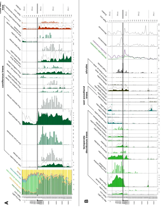
The sediment was relatively rich in plant remains: 88 pollen, 7 spore, 8 NPP (non-pollen palynomorph), 4 stomata and 113 plant macrofossil types were observed along the entire length of the core. Plant macrofossil abundance of trees and shrubs was exceptionally high in the top 175 cm of the core. The pollen zonation resulted in 5 significant assemblage zones (PH-1 to 5). For the zones and detailed vegetation changes see Supplementary Table 1. The main plant macrofossil types are presented in Figure 3., pollen and plant macrofossil diagrams are presented in Figures 4 & 5.
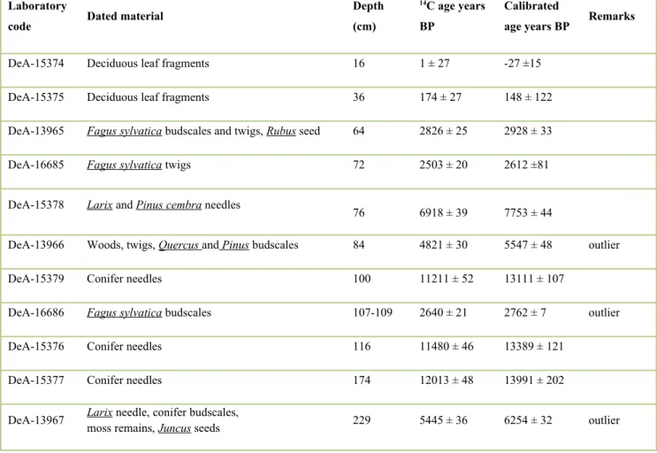
Fig. 3. Plant macrofossil remains from Nagy-forrás forest hollow. The pictures were taken with a Zeiss SteREO Discovery.V12 microscope in the Institute of Archaeology of the Research Centre for the Humanities (Hungarian Academy of Sciences)
244
246
248
Fig. 4. Pollen percentage diagrams of selected tree and shrub pollen types and concentration diagrams of the selected plant macrofossils.
A. Coniferous trees and cold-tolerant deciduous trees.
B. Temperate deciduous trees, wet woodland trees and shrubs.
The stacked bar chart shows the relative proportion of the different vegetation types (based on pollen record). Filled line charts represent the pollen proportions in percentage, where 100% is the sum of all terrestrial taxa (see total terrestrial pollen), the exaggeration factor (black line) was 3. Grey bar charts: stomata concentrations (pieces in 1 cm3). Bar charts:
macrofossil concentrations (pieces in 5 cm3). Line charts: the total pollen concentration (in 1 cm3) and charcoal records
Fig. 5. Pollen percentage diagram of selected herb pollen types and concentration diagrams of selected plant macrofossils. Filled line charts represent the pollen proportions in percentage, where 100% is the sum of all terrestrial taxa (see total terrestrial pollen), the exaggeration factor (black line) was 3. Bar charts: macrofossil remains concentrations (pieces in 5 cm3)
PH-1, 240-200 cm, 15 425-14 615 cal yr BP
The bottom zone is composed of sandy sediment with mineral particles and clay and has low organic matter content (LOI < 20%). The equal proportion of terrestrial herb pollen (mainly Poaceae, Artemisia and Ranunculus type) and coniferous tree pollen (Pinus diploxylon type and Picea) suggested open boreal forest vegetation (Figures 4 & 5). The occurrence of cold-tolerant herbs (Selaginella selaginoides, S. denticulata, Oxyria dygina, Saxifraga oppositifolia, S. granulata and S.
stellaria) is notable (Figure 5) and their presence indicates alpine snow beds, wet rock surfaces, grasslands and nearby springs or seep-water. Overall, they are indicative of boreal and wet tundra-like habitats around the hollow. Submerged aquatic species (Batrachium sp.), hydro- and helophytes (Comarum palustre, Caltha palustris, Typha sp., Cyperaceae) and NPP types from this zone indicate shallow, oligo-mesotrophic pond environment. According to the plant macrofossil record the open boreal forest around the lake was dominated by Picea sp., Larix sp. and Pinus sylvestris. The lakeshore was covered by Betula pendula/pubescens trees and Salix sp. shrubs.
PH-2, 200-102 cm, 14 615-12 980 cal yr BP
In zone PH-2, the brown sandy sediment is turning to dark brown (almost black) decomposed sediment with turfa (peat); the amount of organic matter increases through the zone (Figure 2). This zone is the most diverse both in pollen and macrofossil types and is characterized by very well preserved plant and moss remains (Figures 3 & 5). The relatively high proportion of conifer pollen (Picea, Larix decidua, Pinus haploxylon type and diploxylon type) and the abundant finds of L.
decidua, Pinus cembra and Pinus sylvestris needles and stomata suggest the presence of a local European larch-swiss stone pine dominated boreal forest. According to the macrofossils, Betula pendula and B. pubescens grew on the site, too. The presence of Ephedra, Juniperus, Ericaceae, Spiraea, Sambucus and Rubus may point to a relatively rich shrub layer and light-demanding shrubs likely indicate poorly vegetated scree surfaces. The significant proportion of Picea pollen and stomata suggests Norway spruce populations close to the hollow. The diverse moss community (11 species, e.g. Drepanocladus aduncus, Calliergon cordifolium, Supplementary Figure 4) and the presence of Comarum palustre, Caltha palustris, Urtica sp., Carex appropinquata and other Carex species indicate mesotrophic fen habitats in the mire.
PH-3, 102-74 cm, 12 980-7050 cal yr BP
This zone has uniform lithostratigraphy (dark brown, almost black decomposed lake sediment with turfa) and constantly high organic matter content (50-60%). Based on changes in the macrofossil and pollen types (Figure 4), the importance of conifers decreases, while deciduous trees (mostly Quercus, Ulmus and Tilia, see Supplementary Table 1) become more abundant. Larix decidua, Pinus cembra and P. sylvestris macrofossils are still abundant suggesting the persistence of boreal forest elements. L.
250
252
254
256
258
260
262
264
266
268
270
272
274
276
278
280
282
decidua and P. cembra needles were dated directly to 7753 ± 44 cal yr BP (76 cm) suggesting their local persistence in the Holocene. The proportion and the diversity of taxa associated with the herb layer decreased mainly because of the strong increase in the elements of the shrub layer (Corylus, Frangula and Sambucus). This zone is likely a transition between the previous coniferous and subsequent deciduous forest, however the surprisingly young and most likely mixed age at 84 cm (5547 ± 48 cal yr BP; Table 1) suggests that the deciduous tree remains come from a younger layer.
The brown-mosses, Caltha palustris, Comarum palustre, Carex appropinquata disappeared from the wetland vegetation, while the presence of Epilobium, Filipendula ulmaria and Scirpus sylvaticus seeds (Figure 5) point to a tall-herb marsh in the vicinity of the core location. These data suggest that Larix decidua, Pinus cembra and Pinus sylvestris survived until ca. 7050 cal yr BP on the northern slope of Kékes Mount. The presence of macroscopic remains of several temperate deciduous trees like Ulmus sp., Quercus sp. and Fagus sylyatica bud scales, accompanied by 5-15 % Tilia sp. and Corylus sp.
pollen suggest that deciduous trees might have been present locally and were certainly present regionally in the late glacial and early Holocene. However, the absence of directly dated early Holocene or late glacial deciduous plant macrofossils in addition to the different behaviour of the pollen curves warrant that at least some of the macrofossils are contaminations by later animal disturbances. Ulmus sp. was however likely present locally since at least the Late Glacial period, as its macrofossils were more abundant in the late glacial sediment layers than in the Holocene, particularly from 13 600 cal yr BP. The pollen and plant macrofossil data on the whole suggest that the transition from boreal to temperate deciduous forest lagged behind.
Hiatus, 74 cm, 7050 – 2710 cal yr BP
The vegetation showed a rapid transition between 76 and 72 cm, where the conifers were replaced by deciduous trees. One additional sample (74 cm) was analysed to define the length of transition. It indicated an abrupt change that occurred between the 74 cm and 72 cm. The relatively big difference in ages (7050 cal yr BP at 74 cm and 2680 cal yr BP at 72 cm), the sharp transition in the macrofossil composition and the high amount of fungal remains (Cenococcum geophylum sclerotia ) at 74 cm altogether suggest a hiatus at this point (the possible reasons for the hiatus are discussed in the supplementary material).
PH-4, 72-22 cm, 2710-110 cal yr BP
This zone has similar uniform lithostratigraphy to the previous one (PH-3). The organic matter content, after a short decrease between 72 and 55 cm, increased to 80%. At 74 cm (7050 cal yr BP) coniferous tree remains still dominated, while above 72 cm (2710 cal yr BP) Fagus sylvatica remains dominated pointing to the presence of a mixed deciduous forest with F. sylvatica, Quercus, Fraxinus, Carpinus betulus and light-demanding shrubs (Corylus, Sambucus) around the hollow. The high abundance of temperate deciduous tree pollen at this time indicates that these forests developed long 284
286
288
290
292
294
296
298
300
302
304
306
308
310
312
314
316
318
before 2700 cal yr BP. The increased relative frequencies of Campanula and Galium pollen also support the presence of deciduous forest. According to the macrofossils and pollen, Alnus and Salix trees replaced Betula trees in the hollow. The presence of Triticum/Avena pollen from 28 cm (175 cal yr BP) and the increase in Plantago major type and Chenopodiaceae pollen indicate human presence in this time period. According to the historical maps (Biszak et al., 2014) this time period coincides with the time when the people of the foothill villages began to cut the forest in the higher and more distant parts of the mountain too. While on the map of Second Military Survey (1819-1869), only deforestations near to the settlements are marked, the Cadastral Map (from 1887) shows many new clearings and meadows within the 2 km radius of the Nagy-Forrás forest hollow (see Supplementary Figure 2).
PH-5, 22-0 cm, 110 cal yr BP to present
The uppermost zone has a uniform lithostratigraphy and high organic matter content similar to the previous one (PH-4, see Figure 2). The pollen and plant macrofossil composition and thus the inferred vegetation are also similar to the previous zone, but it shows more signs of human disturbance. The increase in the relative proportion of herbs, and the presence of Triticum/Avena, Secale, Ambrosia artemisiifolia, Juglans regia, Abies alba, Pinus diploxylon type pollen and Betula pubescens macrofossils indicate additional deforestation and artificial plantations. Populus, Salix and Alnus macrofossils together with Carex paniculata, Hypericum maculatum, Solanum dulcamara and a large amount of Filicales spores show a community very similar to the present-day vegetation on the site.
Statistical analysis and vegetation trajectory
Altogether 23 pollen types passed the abundance criteria and were used for the principal component (PC) analysis (see Supplementary Table 2). Only the first two axes were statistically significant. The first axis represented 64% of the total variance and showed the difference between the coniferous and deciduous tree dominated vegetation phases (high species scores are attained by coniferous taxa and low scores by deciduous taxa). The second axis represented 11% of the total variance and reflected the openness of the vegetation (high positive taxon scores are attained by Poaceae, Chenopodiaceae, Senecio and Salix). The samples were separated well along the first two axes, grouped according to the pollen zones and followed the succession from open boreal forest to Larix-Pinus forest, and from coniferous to deciduous forest (Figure 6). All other axes were below 5%. Overall, the PC biplot shows that the vegetation trajectory in the investigated sediment profile is unidirectional, i.e., it represents a secular successional series It is notable, too that zones PH-4-5 have distinct different pollen compositions, from that of the transitional PH-3 zone, which is more similar to the Late Glacial and Early Holocene pollen assemblages. Overall, the PC biplot shows that the vegetation trajectory in the investigated sediment profile is unidirectional, i.e., it represents a secular successional series.
320
322
324
326
328
330
332
334
336
338
340
342
344
346
348
350
352
Fig. 6. Principal component analysis (PCA) biplot of main terrestrial taxa. Only the taxa with loadings higher than 0.1 for both axes were plotted. PH 1-5 represents the local pollen zones.
Discussion
On the basis of paleobotanical results, the vegetation history of the area is clearly different from other parts of the North Hungarian Mountains, and also from the Carpathian Basin in general (Feurdean et al., 2014; Magyari, 2015; Magyari et al., 2014; Sümegi et al., 2012). In the Carpathian Basin the transition from boreo-nemoral taiga to temperate deciduous forest started roughly around 11 700-10 100 cal yr BP with the persistence of mixed Scots pine-deciduous (Ulmus, Quercus, Corylus) forests in Transdanubia until ca. 8000 cal yr BP (Magyari, 2015). The long-term existence of a conifer population at relatively low altitude (685 m a.s.l.) is unprecedented in the region during the Holocene (Feurdean et al., 2014; Gardner, 2002; Jakab and Sümegi, 2010; Magyari et al., 1999, 2001, 2008;
Sümegi and Náfrádi, 2015; Willis et al., 1995, 1997; Willis and van Andel, 2004), and suggests that the northern slope of Kékes could have served as a refugium for coniferous species.
Regional to local distribution patterns of coniferous species – a Holocene conifer refugium On the northern slope of Kékes, at least four coniferous species were present during the Late Glacial period: Pinus sylvestris, Pinus cembra, Picea abies and Larix decidua. Two of them (Picea abies and Pinus sylvestris) still have some sporadic native populations in Western Hungary, while P. cembra and L. deciduaare not part of the native flora of present-day Hungary (Fekete et al., 2014). P. abies is one of the main tree species in Europe and covers large areas between 800-1800 m a.s.l. in the Carpathians 354
356
358
360
362
364
366
368
370
and in the Alps (Caudullo and de Rigo, 2016; Leuschner and Ellenberg, 2017). Larix decidua and P.
cembra are less common, their closest mixed stands are located in the upper alpine and subalpine belts in the Alps (between 1100 and 2500 m), and occur as population fragments in the Southern and Eastern Carpathians (1300-1900 m) and in the High Tatra Mountains (Casalegno et al., 2010;
Caudullo and de Rigo, 2016; Leuschner and Ellenberg, 2017). It is well known that all of these conifer species survived the LGM in the Great Hungarian Plain (Magyari et al., 2014; Rudner and Sümegi, 2001; Willis et al., 2000; Willis and van Andel, 2004) and also occurred constantly in the North Hungarian Mountains during the late Pleistocene (see Supplementary Table 3). Although all of these taxa disappeared from the North Hungarian Mountains during the Holocene, their withdrawal dynamics were slightly different.
The recession of Picea abies started between 12 000 and 11 000 cal yr BP and was completed by around 10 000-9 000 cal yr BP in the North Hungarian Mountains (Jakab and Sümegi, 2005; Latałowa and van der Knaap, 2006; Willis et al., 1997). Some isolated P. abies stands possibly remained until 8 000 cal yr BP in the North Hungarian Mountains (Jakab and Sümegi, 2005) and there are signs of P.
abies presence in the study region after 3750 cal yr BP too (Szabó and Félegyházi, 1997). In parallel, it expanded its range to north- and westwards and to higher altitudes in the Alps and the Carpathians (Birks and Willis, 2008; Latałowa and van der Knaap, 2006). Nowadays some extrazonal spruce stands still occur at the lower altitudes, usually in the cool microclimate of deep valley bottoms or at the margins of bogs (Leuschner and Ellenberg, 2017)
In contrast, Pinus sylvestris was an important element of the vegetation in the Carpathian Basin even after the beginning of the Holocene, as it formed extended mixed stands with deciduous trees (Juhász, 2007; Magyari, 2015; Moskal-del Hoyo et al., 2018). Later in the Mid-Holocene its population size dramatically decreased due to competition by deciduous tree species (Jakab and Sümegi, 2005, 2010;
Willis et al., 1997) and only small populations survived mostly at edaphically specialized habitats throughout the whole Carpathian Basin (Tóth et al., 2019).
Larix decidua was also restricted to mid- and high-altitude places in the Early Holocene (10 500-9500 cal yr BP), but some stands survived until 5000 cal yr BP at low altitudes (Wagner et al., 2015) and until around 4000 cal yr BP in the Southern-Carpathians (Magyari et al., 2018). According to pollen and macrofossil evidences, some small population of Larix survived even until historical times in the Polish Carpathians at mid (640-680 m a.s.l) altitudes (Krąpiec et al., 2016), in the Czech Republic (Kuneš and Abraham, 2017) and were later eliminated by human deforestation. Overall, this species has small refugial populations in the Carpathian Mountains today (Mihai and Teodosiu, 2009; Fărcaş et al., 2013).
While P. abies and P. sylvestris have broad distributions, the present-day area of P. cembraand Larix decidua are smaller compared to the period before the Holocene. Based on charcoals preserved in cave sediments and loess deposits, we can say that P. cembra was already present in the North Hungarian Mountains 140 000 years ago (Greguss, 1940; Sárkány, 1937) and its stands also occurred in the 372
374
376
378
380
382
384
386
388
390
392
394
396
398
400
402
404
406
408
Hungarian Plain at lower altitudes (Hermann, et al., 1956; Jánossy, 1961; Magyari, 2015; Magyari et al., 1999; Stieber, 1967, 1969). With the warming after the LGM, it also appeared at higher altitudes:
it colonized the mid-altitudes (450-750 m a.s.l.) in the West Beskids and Poprad basin at ~15 500 cal yr BP (Krapiec and Margielewski, 2003; Kuneš et al., 2008; Margielewski et al., 2003, 2010), and the subalpine region earliest at 16 000 cal yr BP in the Alps (Hofstetter et al., 2006). It reached the subalpine regions of the Southern Carpathians around 14 500-12 850 cal yr BP in the Retezat (Magyari et al., 2012; Orbán et al., 2018; Vincze et al., 2017) and was documented in the Rodna Mts.
between ca. 11 250 and 9800 cal. yr BP (Feurdean et al., 2016). In parallel with these events, the conifer-to-deciduous forest change occurred at lower altitudes. Most of the P. cembra populations disappeared from the lowlands and from the mid-mountain regions around 11 500 cal yr BP (Jankovská, 1988; Kołaczek et al., 2017; Kuneš et al., 2008; Willis et al., 1995), or shortly after the beginning of the Holocene at the latest (Jankovská, 1984; Krapiec and Margielewski, 2003; Kuneš and Abraham, 2017; Margielewski et al., 2010; Pokorný et al., 2017). Based on these data, the Holocene P.
cembra stand on the Kékes slope was a small and isolated population, and the area can be designated as a Holocene refugium.
The role of local settings in the formation of the cold refugium
Based on our findings, the question may arise: what made the area capable of preserving the coniferous species (most importantly the Swiss stone pine) until the mid-Holocene? The decline of coniferous trees in the Carpathian Basin was triggered by climate change: in the Early Holocene the climate became warmer and the growing season longer, which allowed the deciduous trees to outcompete the previously dominant boreal taiga elements (Tóth et al., 2015). Coniferous trees, in general, were driven back to colder areas and/or areas that had a more continental climate with frequent late frosts, often with otherwise unfavourable soil conditions, e.g., poor in nutrients, mildly acidic, shallow, or with bad water supply (Huntley, 1990; Leuschner and Ellenberg, 2017). The long local existence of a coniferous forest around the Nagy-forrás forest hollow could be supported by the shallow soil layer of the steep slope or by the waterlogged soil in the hollow.
In addition to the edaphic reasons, the presence of P. cembra suggests that the area had a colder and more humid mesoclimate. Compared to the deciduous trees and to other coniferous species, P. cembra requires a colder (9-16 °C summer average temperature), and more humid (min. 700 mm yearly precipitation) climate (Leuschner and Ellenberg, 2017). Although it can also appear in areas with slightly warmer conditions that are still not suitable for deciduous trees, but it generally cannot compete in these areas with Picea abies or even with Larix decidua, which otherwise forms mixed forests with Swiss stone pine (Casalegno et al., 2010; Caudullo and de Rigo, 2016). Moreover, P.
cembra tolerates frost exceptionally well (until -10 °C in summer, and -70 °C in winter), but the summer warm period can be lethal for its populations, if it reaches 30 °C (Leuschner and Ellenberg, 2017). Based on these facts, the local persistence of Swiss stone pine suggests that the Nagy-forrás 410
412
414
416
418
420
422
424
426
428
430
432
434
436
438
440
442
444
forest hollow and its neighbourhood have been decoupled from the regional climate and represented a cooler and more humid environment.
There is no direct evidence for the present-day cooler micro/mesoclimate in absence of microclimate measurements in this area. However, the cold microclimate and the possibility of a cold refugium is supported by the presence of the cold-tolerant montane and subalpine plant species, that would be otherwise absent at this altitude in Hungary (e.g. Polygonatum verticillatum, Woodsia alpine, Rosa pendulina, Valeriana tripteris, Vojtkó et al., 2010). In addition, the topography of the area (e.g. north facing slope and local depression) theoretically makes a slightly colder microclimate possible: the north facing slopes are generally characterized by shorter growing seasons, less solar radiation and lower maximum temperature (Dobrowski, 2011; Geiger and Bouyoucos, 1951; Körner, 2003). On the one hand, the steep slopes can also be dry, as the soil layer is shallow and water runoff is high (Dobrowski, 2011), on the other hand, the convergent environments (basins, local depressions, sinks) pool cool air and accumulate soil and water (Dobrowski, 2011). Thus the combination of north facing slope and local depression together could facilitate a cool and humid micro/mesoclimate in case of Nagy-forrás forest hollow too.
This possible decoupling from the macroclimate of the northern slope of Kékes might be especially important in the light of recent climate change. The discovery of areas with cool and humid microclimate is a hot topic in conservation biology (Suggitt et al., 2018), not only because they can preserve glacial relict species, but also because they are able to buffer the effects of the warming climate (Maclean et al., 2015; Suggitt et al., 2011), and thus they can potentially function as refugia for species threatened by present-day climate change (Dobrowski, 2011; Suggitt et al., 2011, 2018). In absence of other disturbances, the stands of these areas are also more resistant to the invasions triggered by climate change (Suggitt et al., 2011, 2018). The identification of past microrefugia could be a helpful tool in conservation biology, but in most cases their exact landscape positions are difficult to localize (Dobrowski, 2011). This fact underlines the importance of the conifer refugium around the Nagy-forrás forest hollow. The significance of these findings is further strengthened by the fact that the northern slope of Kékes is covered by a relatively undisturbed beech forest today (Czájlik, 2009), and beech is threatened by climate change in Hungary (Czúcz et al., 2013; Mátyás et al., 2010).
When did beech colonize the local forest? What are the chances for its survival under global warming?
Fagus sylvatica survived the LGM both in Southern European and in small Central European northern (cryptic) refugia, and started to spread at the beginning of Holocene (Huntley, 1990; Magri, 2008;
Magri et al., 2006). On the basis of our current knowledge, the Carpathians were colonized both from southern refugia and from cryptic refugia. The first signs of the beech presence in the Holocene are from Moravia (8900-10 200 cal yr BP, Magri, 2008), from the Vihorlat (11 500 cal yr BP, Wiezik et 446
448
450
452
454
456
458
460
462
464
466
468
470
472
474
476
478
al., 2019), from the Little Carpathians (11 000 - 10 000 cal yr BP, Wiezik et al., 2019) and from Western Hungary (8200-11 400 cal yr BP, Magyari, 2002).
In the northern part of the Carpathians (Tatra) its first detection times (>2%) date back to 9700 - 8900 cal yr BP (Magyari, 2002; Wiezik et al., 2019), while apparent local presence in Apuseni Mountains dates to ca. 9400-9000 cal yr BP (Bodnariuc et al., 2002; Grindean et al., 2015). There are signs of the presence of beech stands from 7000 cal yr BP in Rodna (Grindean et al., 2019; Tanţău, Geantă, et al., 2014), from 6500-6700 cal yr BP in the South Carpathians (Magyari et al., 2018) and from ca. 5100- 4800 cal yr BP in Maramureş and Gutin Mts., (Björkman et al., 2003; Fărcaş et al., 2013).
Based on sites from similar altitude as the Nagy-Forrás (600-1200m), beech became present at ca. 5- 6000 cal yr BP (Apuseni Mts., Retezat hivatkozások). (Bodnariuc et al., 2002) (Magyari et al., 2018).
Beech started to expand at the mid altitudes of Eastern and Southern Carpathians between 5200 – 4500 cal yr BP (Feurdean, 2005, 2010; Grindean et al., 2014, 2019; Tanţău, Geantă, et al., 2014) and became dominant ca. 4000 cal yr BP ago (Feurdean et al., 2011). At the lower altitudes of mountains (300-600 m a.s.l.), in the plains and more continental parts of the Carpathians, F. sylvatica expanded around 4800-4000 cal yr BP (Czerwiński et al., 2019; Grindean et al., 2014) or between 3700-3000 cal yr BP (Magri, 2008; Magyari, 2002; Tanţău, Feurdean, et al., 2014) at latest.
In the North Hungarian Mountains F. sylvatica became remarkable between 7900-4500 cal yr BP, then it attained its present day distribution by 3100 cal yr BP when it replaced temperate deciduous tree (mostly Ulmus sp . , Corylus avellana and Quercus sp . ) species (Gardner, 2002; Magyari, 2002;
Magyari et al., 2010; Willis et al., 1998). F . sylvatica might have been present from 9000-8000 cal yr BP according to the pollen record (exceeded 10%) at the Nagy-forrás forest hollow; however, the formation of the beech-dominated mixed forest cannot be pinpointed on the timeline because of the hiatus. The first direct evidence of the beech-dominated forest is after the hiatus (from 2710 cal yr BP), but most likely beech overtook dominance on the northern slope of Kékes earlier, at latest 3100 year ago.
Fagus sylvatica has reached its maximum distribution in Europe by present (Bradshaw et al., 2010;
Giesecke et al., 2006; Magri, 2008; Saltré et al., 2013), and dominates almost all physiologically suitable habitats by outcompeting other deciduous tree species (Leuschner and Ellenberg, 2017).
However, beech is sensitive to late frosts and summer drought (Fang and Lechowicz, 2006; Leuschner and Ellenberg, 2017; Packham et al., 2012), so most of the beech population is found in areas with Atlantic climate, mild winters (minimum -2.3 °C coldest-month mean temperature) and humid summers with minimum 520-1000 mm annual precipitation (Leuschner and Ellenberg, 2017; Magyari et al., 2010; Packham et al., 2012; Sykes et al., 1996). Nevertheless, beech populations in the Carpathian Basin grow close to their xeric limits, and therefore they are threatened by warming climate (Garamszegi and Kern, 2014; Salamon-Albert et al., 2016). Climate models for the Carpathian 480
482
484
486
488
490
492
494
496
498
500
502
504
506
508
510
512
514
Basin predict the disappearance of the so-called ‘beech climate’ from Hungary until AD 2100 (Czúcz et al., 2013; Mátyás et al., 2010). The frequency of late frost can also have a significant role in the long-term survival of beech (Fang and Lechowicz, 2006; Leuschner and Ellenberg, 2017), and both model results (Rigby and Porporato, 2008) and field observations (Augspurger, 2013) show the increasing risk of late spring frosts in the future in the Carpathian Basin. However, these models use only the regional climate parameters and do not take into consideration the adaptive potential of beech and the effect of cold and humid microclimatic patches (Lenoir et al., 2017; Suggitt et al., 2018) and the human-induced changes of distribution in the past several centuries.
If the northern slope of Kékes Mount was decoupled from the regional climate in the Early Holocene, it could preserve a cooler and more humid micro- and mesoclimate during the ongoing climate change too. As the distribution of beech is limited by drought (Fang and Lechowicz, 2006; Leuschner and Ellenberg, 2017; Packham et al., 2012), it is plausible to suggest that an area with a humid mesoclimate could support the survival of local beech populations. In addition, it was shown previously that undisturbed communities are more resistant against the effects of climate change (Suggitt et al., 2018), and the area is covered by a relatively undisturbed primary beech forest today (Czájlik, 2009).
Based on the vegetation history of the studied area, the combination of a more humid microclimate and the lack of strong human disturbances can make the northern slope of Kékes an important target for the long-term conservation of beech forests in Hungary.
Conclusions
The macrofossil, pollen and stomata analyses of the sediment of Nagy-forrás forest hollow are the first stand-scale paleoecological studies in Hungary. Since small and undisturbed forest hollows are rare at mid-altitudes under continental climate, Nagy-forrás forest hollow (685 m a.s.l) provided a rare opportunity to analyze the local vegetation patterns. The studied sediment profile showed an unidirectional vegetation trajectory from an open boreal forest and wet tundra-like habitat (15 500-14 600 cal yr BP) to a European larch-Swiss stone pine (Larix decidua-Pinus cembra) forest (14 600- 7050 cal yr BP) and later, after a hiatus between c. 7050 and 2710 cal yr BP, to a beech (F. sylvatica) dominated mixed temperate deciduous forest, similar to the current forest cover. Anthopogenic influence was indicated by the presence of cereal pollen from 175 cal yr BP, while modern deforestation and artificial plantations started from 110 cal yr BP.
The most important finding of our study is that coniferous trees (Pinus sylvestris, P. cembra, Larix decidua and Picea abies) survived until the mid-Holocene on the northern slope of Kékes Mount.
Swiss stone pine macrofossils have never been found in Holocene sediments in Hungary before. The long-lasting presence of the coniferous tree species suggests that the study area was decoupled from 516
518
520
522
524
526
528
530
532
534
536
538
540
542
544
546
548
the regional climate and did not follow the patterns of regional vegetation changes. Given that our study area was a cold conifer refugium during the Holocene, we assume it can play the same role for present day beech forests which are threatened by recent climate change in Hungary.
Acknowledgements
We thank the help of Erzsébet Szurdoki, the curator of the Seed Collection at the Hungarian Natural History Museum, and Anett Miháczi-Pálfi, a department member of the Institute of Archaeology at the Research Centre for the Humanities (Hungarian Academy of Sciences), who helped in plant macrofossil identification and documentation. Zs. Pató also thanks the encouragement and professional support of the members of MTA-MTM-ELTE Paleoecology Research Group (especially for Ilona Pál, Ildikó Vincze and Valéria Pálházi) and Ildikó Orbán and Márton Mucsi. We also express our sincere thanks to the Bükk National Park Directorate for their assistance in the fieldwork and we thank the help of Gábor Magos and other national park guards with locating potential forest hollows.
The Authors declare that there is no conflict of interest.
Funding
Our research was supported by the National Research, Development and Innovation Office [NKFIH K129167], the European Union and the government of Hungary [European Regional Development Fund, GINOP-2.3.2.-15-2016-00009 ‘ICER’].
Figure legend:
Fig.1. Location of Nagy-forrás forest hollow in the Carpathian Basin and in the Mátra Mountains.
Fig.2. The results of age-depth modelling, lithostratigraphical description and loss on ignition measurements of the Nagy-forrás forest hollow, core PM- 1. The symbols of the lithography follow the Troels-Smith nomenclature: Th- Turfa herbacea, Ld-Limus humosus, Ag-Argilla granosa, As-Argilla steatodes, Ga-Grana arenosa, Gs-Grana saburralia, Gg-Grana glaerosa (min)
550
552
554
556
558
560
562
564
566
568
570
572
574
Fig. 3. Plant macrofossil remains from Nagy-forrás forest hollow. A. Larix sp.
dwarf shoot B. Larix sp. needle tip C. Larix decidua cone D. Larix decidua seed E. Pinus sylvestris needle F. Pinus cembra needle G. Betula pubescens fruit H. Fagus sylvatica twigs I. Populus sp. budscales J. deciduous leaf fragments K. Batrachium sp. seed L. Carex sp. perigynium M. Caltha palustris seed N. Scirpus sylvaticus fruit O. Solanum sp. seed. The pictures were taken with a Zeiss SteREO Discovery.V12 microscope in the Institute of Archaeology of the Research Centre for the Humanities (Hungarian Academy of Sciences)
Fig. 4. Pollen percentage diagrams of selected tree and shrub pollen types and concentration diagrams of the selected plant macrofossils.
A. Coniferous trees and cold-tolerant deciduous trees.
B. Temperate deciduous trees, wet woodland trees and shrubs.
The stacked bar chart shows the relative proportion of the different vegetation types (based on pollen record). Filled line charts represent the pollen proportions in percentage, where 100% is the sum of all terrestrial taxa (see total terrestrial pollen), the exaggeration factor (black line) was 3. Grey bar charts: stomata concentrations (pieces in 1 cm3). Bar charts: macrofossil concentrations (pieces in 5 cm3). Line charts: the total pollen concentration (in 1 cm3) and charcoal records
Fig. 5. Pollen percentage diagram of selected herb pollen types and concentration diagrams of selected plant macrofossils. Filled line charts represent the pollen proportions in percentage, where 100% is the sum of all terrestrial taxa (see total terrestrial pollen), the exaggeration factor (black line) was 3. Bar charts: macrofossil remains concentrations (pieces in 5 cm3)
Fig. 6. Principal component analysis (PCA) biplot of main terrestrial taxa. Only the taxa with loadings higher than 0.1 for both axes were plotted. PH 1-5 represents the local pollen zones.
Table legend:
Table 1. Results of AMS 14C measurements from Nagy-forrás forest hollow (core PM-1) – in text
576
578
580
582
584
586
588
590
592
594
596
598
600
602
604
References
Augspurger CK (2013) Reconstructing patterns of temperature, phenology, and frost damage over 124 years: Spring damage risk is increasing. Ecology 94(1): 41–50. DOI: 10.1890/12-0200.1.
Bennett K (2008) Psimpoll and Pscomb. en. http://chrono.qub.ac.uk/psimpoll/psimpoll.html.
Available at: http://chrono.qub.ac.uk/psimpoll/psimpoll.html.
Bennett KD and Willis KJ (2001) Pollen. In: Smol JP, Birks HJB, Last WM, et al. (eds) Tracking Environmental Change Using Lake Sediments: Terrestrial, Algal, and Siliceous Indicators.
Dordrecht: Springer Netherlands, pp. 5–32. DOI: 10.1007/0-306-47668-1_2.
Berggren G (1981) Atlas of Seeds. Part 3. Salicaceae-Cruciferae. Stockholm: Swedish Museum of Natural History.
Beug H-J (2004) Leitfaden der Pollenbestimmung für Mitteleuropa und angrenzende Gebiete.
München: Verlag Dr. Friedrich Pfeil.
Birks HH (2003) The importance of plant macrofossils in the reconstruction of Lateglacial vegetation and climate: examples from Scotland, western Norway, and Minnesota, USA. Quaternary Science Reviews 22(5–7): 453–473. DOI: 10.1016/S0277-3791(02)00248-2.
Birks HH (2007) Plant Macrofossil Introduction. In: Encyclopedia of Quaternary Science 3. Elsevier, pp.
2266–2288. DOI: 10.1016/B978-0-12-409548-9.10499-3.
Birks HH and Birks H (1975) 4. PLANT MACROFOSSILS.: 38.
Birks HH and Birks HJB (2006) Multi-proxy studies in palaeolimnology. Vegetation History and Archaeobotany 15(4): 235–251. DOI: 10.1007/s00334-006-0066-6.
Birks HJB (1996) Contributions of Quaternary palaeoecology to nature conservations. Journal of Vegetation Science 7: 89–98.
Birks HJB and Birks H (2000) Future uses of pollen analysis must include plant macrofossils. Journal of Biogeography 27(1): 31–35. DOI: https://doi.org/10.1046/j.1365-2699.2000.00375.x.
Birks HJB and Willis KJ (2008) Alpines, trees, and refugia in Europe. Plant Ecology & Diversity 1(2):
147–160. DOI: 10.1080/17550870802349146.
Bíró K (1984) Őskori leletek a Mátra hegységből. AGRIA 20: 5-11.
Biszak E, Kulovits H, Biszak S, et al. (2014) Cartographic heritage of the Habsburg Empire on the web:
the MAPIRE initiative.: 6.
Björkman L, Feurdean A and Wohlfarth B (2003) Late-Glacial and Holocene forest dynamics at Steregoiu in the Gutaiului Mountains, Northwest Romania. Review of Palaeobotany and Palynology 124(1–2): 79–111. DOI: 10.1016/S0034-6667(02)00249-X.
Blaauw M and Christen JA (2011) Flexible paleoclimate age-depth models using an autoregressive gamma process. Bayesian Analysis 6(3): 457–474. DOI: 10.1214/11-BA618.
606
608
610
612
614
616
618 620
622
624
626
628
630
632
634
636
638