This manuscript is contextually identical with the following published paper: Ujházy N., Biró M. 2018, The ‘Cursed Channel’: utopian and dystopian imaginations of landscape
transformations in twentieth-century Hungary, Journal of Historical Geography 61, 1-13.
The original published pdf available in this website:
https://doi.org/10.1016/j.jhg.2018.01.001
The ‘Cursed Channel’:
utopian and dystopian imaginations of landscape transformation in twentieth-century Hungary
Noémi Ujházya, Marianna Birób
aDepartment of Environmental and Landscape Geography, Eötvös Loránd University, 1117, Budapest, Pázmány Péter stny. 1/c, Hungary, unoemi@gmail.com
bMTA Centre for Ecological Research, Institute of Ecology and Botany, 2163, Vácrátót, Alkotmány út 2-4, Hungary
Abstract
This paper examines the utopian and dystopian discourses surrounding the Main Channel of the Danube Valley, often referred to as the ‘Cursed Channel’, which flows through the eastern floodplain of the Danube southward across the Great Hungarian Plain. Plans for the channel were originally drawn up at the end of the nineteenth century during the era of the Austro-Hungarian Empire, but the channel was only completed after the dissolution of the monarchy in the 1920s. The debates concerning the social and ecological aspects of this project were part of the broader political discourse about modernity, traditionalism and conservation in Hungary. The scheme was first publicly termed the Cursed Channel in 1937 by a politician from the region, Lajos Dinnyés, who later served as Hungary's prime minister for a brief period after World War II. By the late 1940s, with the rise of Soviet influence, Hungary was caught up in the sovietization of science and policy, including water management. In the wake of the gradual communist takeover of Hungary, the epithet of the Cursed Channel gained new currency, influencing discourse on local implementations of the Great Stalin Plan for the Transformation of Nature. Tracing the history of the channel and people's perceptions of it, the paper illuminates the construction of a hydrosocial dystopia, and explores the dialectics of utopian and dystopian imaginations of hydrosocial landscapes. We argue that dystopian and utopian geographical imaginaries connected to the Cursed Channel were influential in the transformations of landscape and hydrosocial governance in twentieth century Hungary.
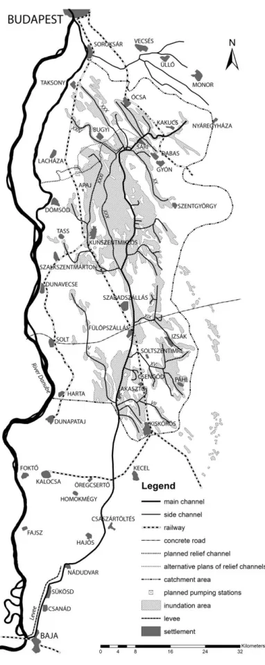
Walking along the nature trails across the wetlands conserved in the Kiskunság National Park, one might notice information signs that mention the striking name of the neighbouring channel: ‘Átokcsatorna’, that is, the ‘Cursed Channel’.1 This name refers to the Main Channel of the Danube Valley (Duna-völgyi főcsatorna, hereafter: DVCS), which was built in the 1910s and 1920s to drain the lower Danube-Tisza Interfluve; it flows through the eastern floodplain of the Danube southward across the Great Hungarian Plain, beginning close to Budapest and joining the Danube in the town of Baja (Fig. 1). Recent decades have witnessed a significant increase in public appreciation of remaining wetlands worldwide.2 In the area, a growing number of wetlands have come under official protection since the 1970s, and several wetland restorations
1 The Hungarian name itself is ambiguous: the compound ‘Átok-csatorna’ can mean both that the channel is cursed and − maybe even more so − that the channel itself is the curse. We chose to use the first meaning because it sounds more natural in English.
2 H. Prince, Wetlands of the American Midwest: A Historical Geography of Changing Attitudes, Chicago, 1997; G.V.T.
Matthews, The Ramsar Convention on Wetlands: its History and Development, Gland, 1993.
have been carried out.3 Despite conservation efforts, however, by the early 1980s there was a severe decline in the level of groundwater in the region, which threatened the sustainability of several lakes and fens.4 Today the channel is blamed for destroying the wetlands, which are now perceived as a valuable part of Hungary's natural heritage. For much of the twentieth century, however, transforming nature by draining wetlands and irrigating drier territories was seen as a necessary part of ‘progress’ in order to increase agricultural productivity.5 This paper examines the history of the DVCS and its surrounding wetlands, from the first plans for the channel in the Austro-Hungarian period at the end of the nineteenth century, through the completion of the drainage scheme in the interwar years of an independent but much diminished Kingdom of Hungary, to the irrigation projects of the post-1945 communist era (Fig. 2). By focusing on the evolution of the channel's perceptions and the discourses surrounding each stage of its development, the paper aims to contribute to the general understanding of the political ecology of hydrosocial governance in Hungary.
The case of the Cursed Channel suggests that political projects are inevitably environmental projects, and that conversely, environmental projects cannot escape being entangled in politics.6 Hence, following Erik Swyngedouw, the social and political context behind the contested meanings of nature should be viewed and investigated as the hybrid entanglements of culture and nature, or hydrology and society.7 As suggested by Rutgerd Boelens and others, hydrosocial territories are understood as ‘the contested imaginary and socio-environmental materialization of a spatially bound multi-scalar network in which humans, water flows, ecological relations, hydraulic infrastructure, financial means, legal-administrative arrangements and cultural institutions and practices are interactively defined, aligned and mobilized through epistemological belief systems, political hierarchies and naturalizing discourses’.8 From our point of view, the ‘Cursed Channel’ can be analysed as an example of a contested imaginary, and as a vehicle to influence and manipulate discourses about hydrosocial territories. Such an approach is valuable and illuminating, given that polarized rhetoric that reduces options to either a ‘blessing or curse’ is not uncommon even today in discussions about water management.9 These sorts of polarized labels expose the utopian/dystopian thinking behind hydromodernization and the control of water in general. Other scholars have already emphasized the role of the geographical imaginary in transformations of hydrosocial landscapes, and the connections between conceptual and material transformations.10 In addition to highlighting the significance of utopian ideas such as utopian hydraulism or hydraulic heroes, studies on the evolution of hydromodernization have also drawn attention to the power of crisis narratives.11 However, there is no reference in the literature to hydrosocial dystopias, while the
3 A. Iványosi-Szabó, Ahogy elkezdődött d a természetvédelem előzményei a Duna−Tisza közén, in: A. Iványosi-Szabó (Ed.), A Kiskunsági Nemzeti Park Igazgatóság Negyven Éve, Kecskemét, 2015, 11−16.
4 B. Kohán and J. Szalai, Spatial analysis of the shallow groundwater level monitoring network in the Danube-Tisza Ridge using semivariograms, Hungarian Geographical Bulletin 63 (2014) 379−400.
5 Similarly to colonial Mexico: A. Sluyter, The making of the myth in postcolonial development: material-conceptual landscape transformation in sixteenth-century Veracruz, Annals of the Association of American Geographers 89 (1999) 394.
6 E. Swyngedouw, Liquid Power: Contested Hydro-Modernities in Twentieth-Century Spain, Cambridge, 2015, 1−37.
7 W. Cronon, Introduction: in search of nature, in: W. Cronon (Ed.), Uncommon Ground: Rethinking the Human Place in Nature, New York, 1996, 23−56; B. Latour, We Have Never Been Modern, Cambridge, 1993; S. Whatmore, Hybrid Geographies, London, 2002.
8 R. Boelens, J. Hoogesteger, E. Swyngedouw, J. Vos, and P. Wester, Hydrosocial territories: a political ecology perspective, Water International 41 (2016) 1.
9 J. van Schilfgaarde, Irrigation − a blessing or a curse, Agricultural Water Management 25 (1994) 203−219; Dams − blessing or curse?, WWF, http://wwf.panda.org/what_we_do/footprint/water/dams_initiative/ last accessed 30 January 2017; D. Tadesse, The Nile: Is it a curse or blessing?, Institute for Security Studies Papers 174 (2008) 1−27.
10 M. Kaika, Dams as symbols of modernization: the urbanization of nature between geographical imagination and materiality, Annals of the Association of American Geographers 96 (2006) 276−301; Sluyter, The making of the myth in postcolonial development.
11 R. Boelens and N.C.P. Uiterweer, Hydraulic heroes: the ironies of utopian hydraulism and its politics of autonomy in the Guadalhorce Valley, Spain, Journal of Historical Geography 41 (2013) 44−58; C. Brannstrom and John Shary, Charles Pease and contested irrigation landscapes in early-twentieth-century South Texas, Journal of Historical
dialectics of utopian and dystopian imaginations of hydrosocial landscapes are rarely addressed directly.12 Taking a historical political ecology approach, our goal is to shed light on the role of utopian/dystopian imaginaries in the socionatural transformation of landscapes, with particular focus on hydrosocial dystopias.13 The use of the term the ‘Cursed Channel’, which was coined in the 1930s, has been tracked in order to grasp both the dystopian and the utopian visions connected to the scheme of the DVCS. Our main task is to illustrate how the rearrangement of hydrosocial territories has been linked to contesting utopian/dystopian imaginaries in twentieth-century Hungary.
Utopias and dystopias are predominantly defined as literary genres describing imagined good or bad places with an ideal or flawed constitution.14 Utopias and dystopias are not neutral;
they have a political message. Whereas utopias challenge the present by providing alternative futures for the way in which relations between environment, technology and society are organized, dystopias, usually identified as anti-utopias, envision failed utopian aspirations.15 Gregory Claeys argues that dystopias are most commonly understood as the failed utopias of twentieth-century totalitarianism, and highlights three typical forms of dystopia: the political dystopia, the environmental dystopia, and the technological dystopia.16 In critical notions surrounding utopias of modern hydrosocial landscapes all three of these aspects can be found, and are typically expressed as intersecting critiques of power, environmental effects and the fallibility of technology. In our analysis we try to explore this plurality of the utopian/dystopian imaginary.17
As Denis Cosgrove has pointed out, the control and appropriation of water can be perceived as an imitation of divine mastery over nature.18 Modernization projects extend the human control of nature by applying new technological means, but modern technocratic utopias themselves can easily turn into dystopias in the case of unexpected environmental risks or blindness towards society. While many studies shed important light on these very risks and blind spots, the relationship of hegemonic power to hydro management has also been investigated by various scholars.19 Water engineering projects in particular often become hotspots of resistance against power.20 From a critical environmental point of view, formerly celebrated water engineering megaprojects have come in for substantial criticism, in part for their harmful and irreversible ecological consequences, but also because of the unequally shared environmental risks and benefits and the general neglect of local social and environmental Geography 38 (2012) 234−246. For more about crisis narratives see: D.K. Davis, The Arid Lands: History, Power, Knowledge, Cambridge, 2016, 166; Swyngedouw, Liquid Power, 40−45.
12 E. Swyngedouw, Modernity and hybridity: nature, regeneracionismo, and the production of the Spanish waterscape, 1890−1930, Annals of the Association of American Geographers 89 (1999) 443−465; Swyngedouw, Liquid Power.
13 D.K. Davis, Historical approaches to political ecology, in: T. Perreault, G. Bridge, and J. McCarthy (Eds), The Routledge Handbook of Political Ecology, London, 2015, 263−275.
14 L.T. Sargent, Utopianism: A Very Short Introduction, New York, 10−32.
15 Sargent, Utopianism, 100; G. Claeys, Dystopia: A Natural History, Oxford, 2017, 5; G. Claeys, News from somewhere:
enhanced sociability and the composite definition of utopia and dystopia, History 98 (2013) 145−173.
16 Claeys, Dystopia, 5; B. Stableford, Ecology and dystopia, in: G. Claeys (Eds), The Cambridge Companion to Utopian Literature, Cambridge, 2010, 259−281.
17 G. Baeten, The spaces of utopia and dystopia: introduction, Geografiska Annaler: Series B, Human Geography 84 (2002) 141−142. For more about the postmodern pluralizing imperative, see D.N. Livingstone, Geographical traditions, Transactions of the Institute of British Geographers 20 (1995) 420−422.
18 D. Cosgrove, An elemental division: water control and engineered landscape, in: D. Cosgrove and G. Petts (Eds), Water, Engineering and Landscape: Water Control and Landscape Transformation in the Modern Period, London, 1990, 1−11.
19 M. Nüsser, Technological hydroscapes in Asia: the large dams debate reconsidered, in: M. Nüsser (Ed.), Large Dams in Asia: Contested Environments between Technological Hydroscapes and Social Resistance, Dodrecht, 2013, 1−14;
K.A. Wittfogel, Oriental Despotism: A Comparative Study of Total Power, New Haven, 1957; D. Worster, Rivers of Empire: Water, Aridity, and the Growth of the American West, New York, 1985; Swyngedouw, Liquid Power; J. Imlay and E.D. Carter, Drainage on the Grand Prairie: the birth of a hydraulic society on the Midwestern frontier, Journal of Historical Geography 38 (2012) 109−122.
20 N.R. Muižnieks, The Daugavpils hydro station and ‘Glasnost’ in Latvia, Journal of Baltic Studies 18 (1987) 63−70; T.
Fleischer, Jaws on the Danube: water management, regime change and the movement against the Middle Danube Hydroelectric Dam, International Journal of Urban and Regional Research 17 (1993) 429−443.
diversity.21 In social and political debates about technology, ecology and power, dystopian and utopian imageries are used to anchor contesting positions. Dystopias of empty wastelands or damaged hydrosocial landscapes, for example, are often countered by utopias of ideally- governed landscapes.22
The tumultuous history of twentieth-century Hungary offers a unique opportunity to follow the rearranged governance of hydrosocial territories, and the role of utopian and dystopian imaginations in these processes. We trace the DVCS scheme's history from its initial plans in the late nineteenth century to the completion of the ‘conquest of swampland’ in the interwar period, and the extension of the scheme by irrigation projects in sovietized Hungary, fuelled by local adaptations of the Great Stalin Plan for the Transformation of Nature.23 Our analysis is mainly based on contemporary published texts, such as newspaper articles, scientific works, parliamentary protocols, pamphlets and maps.24 In addition, we searched for materials in several Hungarian archives, and conducted oral history interviews. Compared to the existing historiography of the DVCS, this paper places special emphasis on the political aspirations and cultural values behind the scheme in the long-term perspective and illuminates the construction and altering characteristics of a hydrosocial dystopia.25
‘A new conquest’ − utopian plans for the construction
A broad section of the Great Hungarian Plain was regularly flooded before the expansive programme of river regulation, which peaked in the nineteenth century.26 During this period, proposals for river regulation in the Kingdom of Hungary, which was part of the Austro- Hungarian Monarchy, represented the largest such schemes in Europe.27 Accordingly, river regulation became a symbol of Hungarian modernism and the nation's political will for development through the regulation of nature.28 After completing the channelization and embankment of the two main rivers, the Tisza and the Danube, the task of draining the inland swamps, including the marshes of the Danube-Tisza Interfluve, was left for a later phase.29 Here, a large wetland area of approximately sixty thousand hectares, fed mainly by rain and groundwater, was left intact by the regulation of the Danube.30 These wetlands, spanning a distance of over a hundred kilometres from north to south, had very diverse ecological
21 Local, small-scale environmental and water management practices are gaining increased attention: F. Berkes, J.
Colding, and C. Folke, Rediscovery of traditional ecological knowledge as adaptive management, Ecological Applications 10 (2000) 1251−1262; C. Pahl-Wostl, Transitions towards adaptive management of water facing climate and global change, Water Resources Management 21 (2007) 49−62; examples of local traditional water management practices in Hungary: B. Andrásfalvy, Vízhaszonvétel és árvízvédelem hagyománya Magyarországon, Magyar Tudomány 6 (2000) 709−720. Changes of water management's perception in Hungary: R. Győri, Vadvíziországtól fokgazdálkodásig, Korall 1 (2000) 20−26.
22 M.W. Ertsen, Colonial irrigation: myths of emptiness, Landscape Research 31 (2006) 147−167. On governance, see Boelens, Hoogesteger, Swyngedouw, Vos, and Wester, Hydrosocial territories, 6−7.
23 Swyngedouw, Liquid Power, 44−51; S. Brain, The Great Stalin Plan for the Transformation of Nature, Environmental History 15 (2010) 670−699; Z. Hajdú, A szocialista természetátalakítás kérdései Magyarországon,1948−1956, in: A. Kiss, G. Mezősi, and Z. Sümeghy (Eds), Táj, Környezet és Társadalom: Ünnepi Tanulmányok Keveiné Bárány Ilona Professzor Asszony Tiszteletére, Szeged, 2006, 245−258; Z. Borvendég and M.
Palasik, Untamed seedlings: Hungary and Stalin's plan for the transformation of nature, in: D. Olšáková (Ed.), In the Name of the Great Work: Stalin's Plan for the Transformation of Nature and its Impact in Eastern Europe, New York, 2016, 126−225.
24 The ADT Arcanum Digitheca was a very rich source: https://adtplus.arcanum.hu/en/ last accessed 30 May 2017.
25 For example: D. Varga, Vizek Könyve, Budapest, 1976, 11−33; L. Fejér, Vizeink Krónikája, Budapest, 2001, 186−187; Z. Károlyi, A Duna-völgy vizeinek szabályozása, in: D. Ihrig (Ed.), A Magyar Vízszabályozás Története, Budapest, 1973, 225−233.
26 D. Ihrig, A magyar medence vízrajza, in: D. Ihrig (Ed.), A Magyar Vízszabályozás Története, 1973, 13−19.
27 Z. Pinke, Modernization and decline: an eco-historical perspective on regulation of the Tisza Valley, Hungary, Journal of Historical Geography 45 (2014) 93.
28 Z. Pinke, Modernization and decline.
29 Z. Károlyi, A Magyar vízi munkálatok rövid története különös tekintettel a vizek szabályozására, in: Ihrig (Ed.), A Magyar Vízszabályozás Története, 50−136.
30 Károlyi, A Duna-völgy vizeinek szabályozása, 225−233.
characteristics, ranging from soda pans with high alkalinity to freshwater marshes and peaty fens, separated from each other by sand dunes and arable lands.31 Wetlands were mainly used adaptively by local inhabitants for grazing livestock, reed cutting, fishing, egg collecting, and hunting.32 Intensive agriculture was hindered by the local and regional discharge of groundwater flowing into the area.33
An integrative regional water regulation plan from the 1850s is known today only via indirect reports, while the earliest surviving plan dates from 1898.34 By creating a main channel on the left side of the Danube Valley, with a connected system of side channels, a huge territory was targeted for drainage; irrigation also formed part of the original plan (Fig. 3).35 One of the authors of the plan, the engineer Elek Zlinszky, expressed his feelings about the wet landscape with these words:
The question arises very often, particularly from strangers who are travelling through the country in the springtime, seeing practically nothing other than water and water, what is the reason why such a huge terrain is an unused wasteland? A person familiar with local conditions must shamefacedly admit that there is no reason other than the indifference of landowners to the issue. It is indeed incomprehensible that when, in the most secluded provinces of the countryside, much progress is made in this regard that near the capital of the country more than a hundred thousand holds [57,500 ha] of swampland is tolerated .... Our aim is to win this large, practically completely useless territory in the heart of the country for civilization, as soon as possible.36
In this excerpt, there is a sense of mission, even of heroic modernization, for the country, and a strong revolt against inaction. For modernizers like Zlinszky, swampland embodied the polar opposite of culture and civilization: it was health hazard, an obstacle to modern transportation and a hindrance to agriculture. This is a vision of a ‘pathological’, underdeveloped landscape as seen by an ‘objective’ traveller, a landscape whose transformation is a moral crusade.37 In Zlinszky's view, inland drainage was a continuation of the heroic work of river regulation in the process of building modern Hungary.
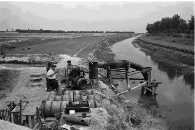
Work on the DVCS only began in 1909, following the formation of the Danube Valley Drainage and Irrigation Association, and construction was delayed several times even after this.38 The digging itself did not start until 1912, construction was slow, and the outbreak of
31 M. Biró, A. Révész, Z. Molnár and F. Horváth, Regional habitat pattern of the Danube-Tisza Interfluve in Hungary, I:
the landscape structure and habitat pattern; the fen and alkali vegetation, Acta Botanica Hungarica 49 (2007) 267−303; M. Biró, A. Iványosi-Szabó and Z. Molnár, A Duna−Tisza köze tájtörténete, in: A. Iványosi-Szabó (Ed.), A Kiskunsági Nemzeti Park Igazgatóság Negyven Éve, 51−52.
32 Varga, Vizek Könyve, 11−33. For the importance of ‘wet farming’ in Hungary, see T. Bellon, Living together with nature. Farming on the river flats in the valley of the Tisza, Acta Ethnographica Hungarica 49 (2004) 243−256.
33 J. Mádlné Szőnyi and J. Toth, A hydrogeological type section for the Duna-Tisza interfluve, Hungary, Hydrogeology Journal 17 (2009) 961−980.
34A Duna-völgyi-főcsatorna Terve, Budapest, 1899; E. Zlinszky, Műszaki Leírás a Pest-megyei Dunavölgy Lecsapolási és Öntözési Tervéhez, Budapest, 1899.
35 For Fig. 3, the 1941 map by Béla Lupkovics has been georeferenced and redrawn using ArcGIS 10.1. The channel system has not been changed, but the settlements, roads and railway lines, and the course of the Danube have been revised according to Military Topographic Survey 1940−1944 (georeferenced and published by Arcanum Ltd and HM HIM on DVD: Magyarország Topográfiai Térképei a Második Világháború Időszakából, Budapest, 2008). The inundation area indicated on Lupkovics's map covers not only marshes and fens, but the less frequently flooded wet meadows as well.
36 Zlinszky, Műszaki Leírás, 8; The hold (or kataszteri hold) is a unit of area that equals 57.55 ha.
37 For a tropical parallel to the aesthetics and hermeneutics of ‘pathologized’ swamplands, see D.N. Livingstone, Tropical hermeneutics and the climatic imagination, in: D.N. Livingstone (Ed.) Science, Space and Hermeneutics, Heidelberg, 2002, 43−73. For malaria control and development see E.D. Carter, Malaria control in the Tennessee Valley Authority: health, ecology, and metanarratives of development, Journal of Historical Geography 43 (2014) 111−127.
38 The formation of Water Associations at this time was regulated by the ‘Water Law’, Act XXIII of 1885 (the texts of the referenced Acts of Parliament are available at Articles in the Codex of Hungarian Laws, http://www.1000ev.hu last accessed 30 January 2017). Membership of the Danube Valley Drainage and Irrigation Association consisted mainly of small and medium landowners and municipal properties; larger, aristocratic landowners like the Coburg- Koháry family or the imperial royal family were few and in the minority in terms of the number of votes they had.
Hivatali és ügyviteli iratok (Pestvármegyei Dunavölgy Lecsapoló és Öntöző Társaság), Pest County Archives, Budapest, IX.314 a. Under the terms of the Water Act, floodplain development taxes were imposed on landowners to cover the cost of construction and maintenance work.
World War I hampered the project still further. Only thirty-two kilometres of channel were completed by 1918, the last year of the war.39 Following the war, the Austro-Hungarian Empire was dissolved and its Hungarian half endured a brief chaotic period of revolution, including a short-lived communist regime. When the Trianon Treaty formally ended the war in 1920, the Hungarian Kingdom shrank to one-third of its former size.40
The desire to realize the Danube Valley's hydromodernization project was rekindled during the conservative-nationalist regime of Regent Miklós Horthy (1920−1944).41 Like ‘El Disastre’ for Spain in 1898, when it lost the last of its colonies, Trianon was perceived commonly as a national catastrophe and catalysed the Hungarian geographical imagination in many ways.42 The main political goal of the Horthy regime was to restore Hungary to its former size, and to prove Hungary's political and cultural supremacy in the Carpathian Basin.43 With a geographical shift of perspective, the regime turned its interest to the wastelands and natural resources of the so-called ‘Truncated Country’, intending to implement modernist notions of natural resource management (and postpone crucial social land reform).44 Drainage of the remaining swamplands as an inner conquest was presented as a cultural mission to expand the space of Hungarians within the new state borders. In 1920 a member of the National Assembly expressed his ‘cultural shame’ over the continued delay of the drainage and the ‘jungle’ of swamps in the middle of the country.45 Construction resumed in 1922, but as financial backing was not secure, progress was slaw.46 The digging work accelerated only after the state provided the Danube Valley Drainage and Irrigation Association with a substantial loan in 1925 and a new ministerial commissioner, the engineer Sándor Rohringer took office.47 For Rohringer the endeavours of water management ‘provided the brightest evidence of the cultural value of the Hungarian race’.48 One newspaper article, bearing the headline ‘The new conquest − occupation of the swampland’, envisioned a technocratic utopia of cultural occupation and ‘golden wheat fields’
within a few years of the drainage scheme being completed (Fig. 4).49
The drainage scheme was only finished in 1931, but due to the lack of finance the related irrigation system that was part of the original plan was not implemented.50 This was an economically difficult and politically charged period in Hungary, worsened by the worldwide
39 Károlyi, A Duna-völgy vizeinek szabályozása, 232.
40 I. Romsics, Dismantling of Historic Hungary: the Peace Treaty of Trianon, 1920, New York, 2002. After the revolutions that took place in the early interwar period, the Hungarian state once more became a monarchy, although without a crowned monarch.
41 B. Lupkovics, A Pestvármegyei Dunavölgy Lecsapoló és Öntöző Társulat Munkálatai és Jövő Feladatai, Budapest, 1941, 3; Károlyi, A Duna-völgy vizeinek szabályozása, 232.
42 Swyngedouw, Liquid Power, 2−3, 39−66.
43 Belief in the so-called ‘Hungarian Cultural Advantage’ was common in Hungarian cultural politics and the politics of science in the period following the signing of the Treaty of Trianon. F. Gyuris, Human geography, cartography, and statistics: a toolkit for geopolitical goals in Hungary until World War II, Hungarian Cultural Studies 7 (2014) 215−241.
44 A significant proportion of Hungary's natural resources lay outside the newborders, so they were now unavailable to the Hungarian state. This led to the promotion of greater rationalization in the use of natural resources, such as the implementation of a new afforestation programme. Z. Hajdú, Táj és állam, in: G. Füleky (Ed.), A Táj Változásai a Honfoglalás óta a Kárpát-medencében, Gödöllő, 1997, 9−20. For a Spanish parallel of modernization as internal colonization, see: Swyngedouw, Liquid Power, 44−51.
45 Jenő Szabóky addressing the House of Representatives, 8 February 1922, Parliamentary Documents, http://mpgy.ogyk.hu/ last accessed 30 January 2017.
46 The Ministry of Agriculture granted a loan to the association, supported by Act XXV of 1922.
47 The new loan was approved by the amendments made in Act IV of 1925. According to Act XLI of 1923, which overwrote the ‘Water Law’ of 1885, the Government Commissioner of a Water Association was authorized to a demand a loan without the consent of the association's assembly.
48 Speech by Sándor Rohringer at the Hydraulic Engineering Department, Hungarian Association of Engineers and Architects, 22 March 1923; published in S. Rohringer, Vizgazdasági politikánk, Vízügyi Közlemények 9 (1923) 1−9.
Compensational cultural politics and water management were similarly intertwined in early twentieth century Spain, in the case of the movement known as ‘regenerationism’: Boelens and Uiterweer, Hydraulic heroes; Swyngedouw, Modernity and hybridity.
49 G. Nyulászi, Az új honfoglalás. Mocsárország meghódítása, Budapesti Hírlap, 6 December 1925.
50 Rohringer Sándor levele az Alispán Úrnak, 20 December 1931, Archives of Environmental Protection and Water Management, Budapest [hereafter KvVL], 15.2 bb, Box 1.
Great Depression. The combination of low grain prices, high levels of debt in the agricultural sector, and the cost of the scheme all meant that the channel drew considerable attention.51
The Cursed Channel − Lajos Dinnyés leads mounting criticism
Soon after its construction, the channel was the subject of mounting criticism and debate, due to several factors, namely the unintended environmental consequences, certain technical mistakes, as well as financial and legal problems. Politicians and journalists were involved in the discussions; one newsreel even depicted the channel flooding in 1936.52 The following two sections will outline how the construction's ostensible failure created an opportunity to criticize different stakeholders. Several − sometimes contradictory − discourses were advanced.
According to oral histories, the affected landowners were divided in their views of the success of the channel scheme.53 Some argued that ‘it couldn't take the water away when it was supposed to, but it did take the water out of the soil when we needed it’. For others, the ‘swamps became fine soil’ and many new farms were built where previously cattle had been herded by boats and children had collected eggs.54 As the following chapters reveal, pictures of local inhabitants either ‘suffering from the channel’ or too ‘lazy to contribute’ were mobilized in the national discourses about the drainage scheme, which unsurprisingly became politically sensitive.55 As an ambitious opposition politician from the region, Lajos Dinnyés was highly critical of the scheme.
Dinnyés articulated his views in a pamphlet, boosting the nationwide criticism of the channel (Fig. 5).56 By studying his arguments in this section, we gain insight into the main issues.
Lajos Dinnyés was born in 1901 into a landed family of modest wealth.57 The newly built channel passed through his hometown, Dabas. After finishing his studies in agriculture he started his political career in the moderate Independent Smallholders Party (Független Kisgazdapárt).58 Thanks to his sociability and practical knowledge of agriculture Dinnyés quickly became popular, winning the local parliamentary election against the pro-government candidate in 1931.59 From this point on, he was heavily engaged with the issue of the channel. He negotiated with hundreds of landowners about problems related to the channel, and gave several speeches on the topic during his two terms in Parliament between 1931 and 1939.60 In 1937, he was the first person in the assembly to use the phrase ‘Cursed Channel’. Before long, the name gained popularity among opposition politicians and was eagerly adopted by the newspapers.61 In 1937, Dinnyés's pamphlet, titled ‘The Cursed Channel’, summarized its history and his criticism of its construction and the government in general.62
51 For more about the indebtedness of landowners from the drainage association,see Lupkovics, A Pestvármegyei Dunavölgy Lecsapoló és Öntöző Társulat Munkálatai és Jövő Feladatai, 3; for the agricultural crisis in general, see I.T.
Berend, Decades of Crisis: Central and Eastern Europe before World War II, Berkeley, 1998, 255−259.
52 The newsreel is available online: Árvíz az Alföldön, Filmhíradók Online, http://filmhiradokonline.hu/watch.php?id¼1796 last accessed 30 January 2017. The channel flooded huge areas in the winter and spring of 1936, 1937 and 1940 owing to underestimation of the amount of groundwater flow. B.
Lupkovics, Árvízi tapasztalatok, Vízügyi Közlemények 23 (1941) 201−207.
53 Varga, Vizek Könyve, 34−40; and the authors' oral history research.
54 Quoted interviewees: Imréné Csősz and Mihály Puskás (Szabadszállás).
55 An international parallel for the way networks were used to control local farmers can be read in M.W. Ertsen, Controlling the farmer: colonial and postcolonial irrigation interventions in Africa, The Journal for Transdisciplinary Research in Southern Africa 4 (2008) 209−236.
56 L. Dinnyés, Az Átokcsatorna, Budapest, 1937. About Dinnyés's biography, see L. Szűcs, Dinnyés Lajos Első Kormányának Minisztertanácsi Jegyzőkönyvei, 8−17; M. Somlyai, Dinnyés Lajos, Társadalmi Szemle 38 (1983) 127−132.
57 L. Czagányi, L. Feldman, Á. Kapui, G. Sztanovszky, and F. Valentyik, Ezer Dabasi Pillanat, Dabas, 2010, 420−441.
58 Szűcs, Dinnyés Lajos Első Kormányának Minisztertanácsi Jegyzőkönyve, 9.
59 L. Lengyel and G. Vidor (Eds), Magyar Országgyülési Almanach. 1931−1936, Budapest, 1932.
60 Hírek. A dunavölgyi csatorna járulékának ügye, Budapesti Hírlap, 17 October 1931; Fábián Miklós dabasi könyvtáros dolgozata Dinnyés Lajosról, National Archives of Hungary, Budapest [hereafter MNL OL], XXXII-21;
Parliamentary Documents, http://mpgy.ogyk.hu/ last accessed 30 January 2017.
61 Dinnyés first mentioned the ‘cursed channel of the Danube Valley Drainage and Irrigation Association’ on 10 March 1937; on 11 June 1937 he refers to the channel, ‘about which I have already spoken, and which also entered common
Despite his misgivings, Dinnyés did not question the basic need for the channel and for hydromodernization. He acknowledged the necessity of drainage because of the damage caused to agriculture by inland inundation, the health concerns arising from swamps, especially the risk of malaria, and finally, the need for better transportation overall. He also saw a need not just for drainage, but also for irrigation, primarily in drought-prone saline grasslands.63
Dinnyés was, however, critical of the numerous technical, legal, and financial problems surrounding the construction of the channel. He demonstrated the harmful environmental effects of the scheme.64 On the one hand, it caused droughts by inducing groundwater-decline.
On the other hand, the scheme generated floods that were less predictable, since the channel itself was prone to inundating large areas. In some years the region experienced both droughts and floods. In addition, there remained territories where the drainage was not effective, which suffered from inland inundation. He also blamed the channel for causing secondary salinization.65 Dinnyés underlined the economic losses faced by local farmers as a result of environmental problems.66 While newly cultivated fields failed to provide the anticipated increase in production, the transformation of former marshlands necessitated substantial additional manual labour, as well as material and financial input. Moreover, traditional practices of land management, involving the usage of reeds or wildlife, all declined after the drainage scheme had was implemented.
He also accused the government of violating the law, first by granting the 1925 loan to the Danube Valley Drainage and Irrigation Association, and then by imposing this arbitrarily upon the stakeholders. Since the water association's assembly was suspended at that time, the government had acted without the association's support and against the interests of self- governance.67 After the drainage scheme began, the many among the local population not only suffered the negative impacts of the channel but also had difficulty paying back the loan instalments to the government, especially as the extra profits promised from the drainage scheme never materialized.68
In light of the immediate concerns raised by the completion of the drainage scheme, Dinnyés argued for a number of financial solutions, like delaying the payment of taxes and loan instalments, as well as technical solutions, such as increased capacities for runoff, sluices, and pumping stations. He stated that the construction of a new relief channel could mitigate the failures of the Cursed Channel by providing a solution for flood control and alleviating drought through irrigation.69 In advancing his arguments, Dinnyés employed hyperbolic and emotive rhetoric as he conjured up images of a dystopian landscape. The ‘poor Hungarians’ of the ‘Valley of Tears’ were suffering not only from environmental disasters such as droughts and floods and
parlance as the Cursed Channel’. Other opposition politicians claimed in Parliament that the channel was not a unique problem, and that there were other ‘cursed channels’ all over the country (1 June 1937). Newspaper articles using this name were published from 1937 in Pesti Napló, Népszava, and Pesti Hírlap. It is fairly well documented that Dinnyés contributed to the promotion of this toponym, but there is no data about whether he created this name or adopted it from locals or others. The exact origin of the name is therefore impossible to reconstruct.
62 Dinnyés, Az Átokcsatorna.
63 L. Dinnyés, Az Átokcsatorna, second edition, Budapest, 1959, 2−5, 24−25.
64 Dinnyés, Az Átokcsatorna, 9−11, 21−23.
65 Dinnyés's argument about large-scale secondary salinization was disproved, since the majority of saline habitats in the region are natural in origin. I. Szabolcs and J. Fink, Salt Affected Soils in Europe, Hague, 1974. Secondary salinization as a significant contributing factor in desertification processes was also proved exaggerated in the drylands of Africa: D.S.G. Thomas and N.J. Middleton, Salinization: new perspectives on a major desertification issue, Journal of Arid Environments 24 (1993) 95−105.
66 Dinnyés, Az Átokcsatorna, 11e12.
67 The Danube Valley Drainage and Irrigation Association had its autonomy suspended and was led by government commissioners from 1917 to 1934, and from 1937. Dinnyés, Az Átokcsatorna, 8, 12−16, 20−21.
68 Taxation was a commonly used tool to fund government water management projects worldwide, and often meant a burden on landowners. Pinke, Modernization and decline, 100−102; Imlay and Carter, Drainage on the Grand Prairie;
D.P. Gamero, From private initiative to public intervention in Spanish water management: the case of the Muga and Fluvià rivers (1850−1930), Journal of Historical
Geography 38 (2012) 220−233.
69 Dinnyés, Az Átokcsatorna, 23−26, 25.
salinization, but also from an autocratic government unable to represent its own people in an
‘age of crises’.70
Conflicting perspectives of conservation, traditionalism and modernity
Dinnyés's views of the DVCS were part of a wider debate about modernity and progress and their consequences on traditional life. The rise of a modern conservation movement made the debate even more complicated.71 In 1919 a leading Hungarian ornithologist, Jakab Schenk, had proposed founding a nature reserve in the northern wetlands of the Danube-Tisza Interfluve, justifying his proposal by pointing to the region's unique environmental characteristics.72 His modernistic vision of a nature reserve as a space for wildlife made it necessary in his mind to relocate the entire human population away from the territory, primarily because these people were, from his point of view, ‘the most dangerous poachers and egg collectors since ancient times’.73 His ideas mirrored the vision of those who promoted national parks in the American West as an uninhabited wilderness, where groups of people whose subsistence was derived from hunting and trapping were criminalized.74 Outside the core territory, Schenk imagined extensive grazing land with dairy farms combined with intensively cultivated arable plots supported by irrigation and modern fertilizer usage.75 The plan for a nature reserve had not been considered in plans for the channel system, as Károly Kaán, an influential nature conservationist from this time, lamented in his Nature Conservation and Natural Values.76 Botanists started to document the flora and vegetation of the wetlands before they were transformed forever by the drainage schemes.77
These naturalists did not articulate their concerns as expressively as the journalist László Szalay. He argued that the drainage channel caused dramatic environmental consequences such as groundwater decline, secondary salinization, and even a change in climate, which made a dystopian ‘desert out of the Great Hungarian Plain’.78 Szalay, the son of a local landowner and also a keen hunter and amateur ethnographer, spent much of his time in the marshlands and was interested in the local peasants' points of view about the environment. In his writings, he pictured an anti-modern, Arcadian harmony of traditions, describing the wise adaptation of the local inhabitants to the wet environment: grazing at the deepest parts, mowing in the periphery of marshland and sowing root crops on the wet fields and cereals on the highest parts.79 He labelled the environmental consequences of the channel a ‘national catastrophe’, and pictured
70 Dinnyés, Az Átokcsatorna, 22, 25−26; Lajos Dinnyés addressing the House of Representatives, 5 June 1937, Parliamentary Documents, http://mpgy.ogyk.hu/ last accessed 30 January 2017.
71 Similar criticisms of drainage were raised by the growing conservation movement in the American Midwest during the 1930s, where soil degradation and fires were caused by drained peatbogs. Prince, Wetlands of the AmericanMidwest, 7−8.
72 J. Schenk, Az őstermészet kincseinek védelme magyar földön, Természettudományi Közlöny 51 (1919) 241−251.
73 Schenk, Az őstermészet kincseinek védelme magyar földön, 245. On utopia and wilderness, see Whatmore, Hybrid Geographies, 12−15.
74 M.D. Spence, Dispossessing the Wilderness: Indian Removal and the Making of the National Parks, New York, 1999;
K. Jacoby, Crimes Against Nature: Squatters, Poachers, Thieves, and the Hidden History of American Conservation, Berkeley, 2014.
75 Recent research shows that complex management regimes, based on traditional animal husbandry, can be effective at maintaining high biodiversity in wet meadows in this region. C. Vadász, A. Máté, R. Kun, and V. Vadász-Besnyői, Quantifying the diversifying potential of conservation management systems: an evidence-based conceptual model for managing species-rich grasslands, Agriculture, Ecosystems and Environment 234 (2016) 134−141.
76 K. Kaán, Természetvédelem és Természeti Értékek, Budapest, 1931, 130−134.
77 G. Moesz, A Kiskunság rétségei, Természettudományi Közlöny 8 (1935) 374−377; Á. Boros, A Duna-Tisza köze kőriserdői és zsombékosai, Botanikai Közlemények 33 (1936) 84−97.
78 Worries about the ‘desertification’ of the Great Hungarian Plain were not new; they had already emerged after the river regulation. F. Jankó, Elfeledett viták az alföldi erdősítés és vízrendezés éghajlati hatásairól, Földrajzi Közlemények 137 (2013) 51−63.
79 L. Szalay, Adalékok az alföld problémáihoz. Hogy lesz az Alföldből sivatag?, Pesti Hírlap, 3 October 1930; L. Szalay, Rétek, vízibaromfiak, Magyarság, 31 August 1930. He also wrote novels about rural traditional life as László Zalay- Szalay: L. Zalay- Szalay, A Puszta Balladája, Budapest, 1930; L. Zalay-Szalay, Öreg Szuhay, Budapest,1942.
the channel as draining the life-giving water of a ‘bleeding Hungary’. He claimed that, ‘There is no mortal enemy or pest for the Hungarians in all of Europe greater than this channel’.80 In contrast to Dinnyés, Szalay did not advocate technical corrections since he deemed it impossible to resolve the problem with further channels. Instead, he called for the complete destruction of the DVCS, provoking a storm of protest from the engineers.81
It is noteworthy how the supporters of the channel reacted to these assaults. Rohringer, who was singled out for criticism by both Dinnyés and Szalay, started to study the groundwater of the region and, with the support of a governmental research grant, established the first groundwater-monitoring network in Hungary.82 He responded to the objections in scientific journals and newspaper articles, and argued that the groundwater decline was not critical and that fears of secondary salinization were unfounded.83 The channel was supported not only by water engineers, but also by a variety of scholars involved in research into soil amelioration and techniques of agrodevelopment, who usually took a cooperative approach towards the government. One was Elek ‘Sigmond, a well known soil scientist, who explained that the problem lay only in the work's lack of completion, and that drainage should be followed by modern amelioration.84 At Lake Kolon, experts in pedology and agrochemistry experimented with the cultivation of former wetlands using tree plantations, crops and hay meadows. The authors offered instructions to landowners on how to convert this backward ‘barren, boggy landscape’.85 Experiments in soil improvement through irrigation and by utilizing chemicals were attempted near the town of Kunszentmiklós.86 Instead of highlighting the errors of the government, as Dinnyés did, some of the authors of these articles argued that the ‘Hungarian race’ should be more open and progressive to the changes and welcome the Green Field Movement (Zöldmező Mozgalom), which advocated the local introduction of new agricultural technologies.87 The issues of irrigation and flood control that formed part of Dinnyés's pamphlet were also discussed extensively. In the dry years of the 1930s nationwide debates prevailed about the
‘desertification of the Great Hungarian Plain’ and about irrigation as a possible solution.88 In other parts of the country, new irrigation systems were built, but not in the Danube-Tisza Interfluve.89 In the wet years of the 1940s, however, the idea of extending drainage to the higher
80 L. Szalay, A pusztuló alföld, Magyarság, 25 July 1935.
81 Szalay, A pusztuló alföld; B. Kenessey, Az Alföld állítólagos kiszárítása, elszikesítése és öntözésének kérdése, Vízügyi Közlemények 13 (1931) 1−27; F. Jankó, Éghajlatingadozás és éghajlatváltozás: adalékok Réthly Antal hagyatékából, Légkör 61 (2016) 81−85.
82 Dinnyés, Az Átokcsatorna, 9; L. Szalay, Válasz Rohringer Sándornak. Viták a csatornák körül, Magyarország, 20 August 1935; Á. Kenyeres (Ed.), Magyar Életrajzi Lexikon: 1000−1990, 2001, http://mek.oszk.hu/00300/00355/html/ last accessed 11 September 2017.
83 S. Rohringer, Talajvíztanulmányok a DunaeTisza-közén, Vízügyi Közlemények 16 (1936) 31−46; response letter: S.
Rohringer, Harc a dunavölgyi csatorna és a szikesföld ellen, Budapesti Hírlap, 17 May 1930. Rohringer also edited a column about soil improvement and water management in the newspaper Köztelek, where he frequently published his writings.
84 E. Sigmond, Szakértői Vélemény a Pestvármegyei Dunavölgy Lecsapoló és Öntöző Társulat Szikes Területének Lecsapolásáról és a Lecsapolás Következtében Várható Gazdasági Hasznáról, Budapest, 1930; L. Thaisz, A Pestmegyei Dunavölgy Területének Rét és Legelőgazdasági Munkaterve, Budapest, 1930.
85 I. Prettenhoffer and F. Somorjai, Utmutató a Kolontó Hasznositására az 1935−1939. Években Végzett Kisérletek Alapján, Szeged, 1940, 20. On critique of the drainage of Lake Kolon, see B. Rajna, A ‘Kolontó’ drámája, Pesti Napló, 18 August 1935. For a report about peat fires and other problems, see G. Féja, Ég a Kolontó, Magyarország, 25 August 1935.
86 S. Herke, Szódás talajú lecsapolt területeken végzett hasznosítási kísérletek, in: E. Sajó and Á. Trummerer (Eds), Magyar Szikesek, Budapest, 1934, 300−347.
87 B. Taxner, A Dunavölgy Pestvármegyei részének vízrendezése, Vízügyi Közlemények 20 (1938) 303. (At the end of Taxner's article Mussolini's Bonifica Integrale was mentioned as a model for modern amelioration. At that time, Hungary had friendly relations with Mussolini's Italy.); Lupkovics, A Pestvármegyei Dunavölgy Lecsapoló és Öntöző Társulat Munkálatai és Jövő Feladatai, 4. Against Lupkovics, Géza Féja reported the distrust felt by locals towards the experts of ‘Green Field Movement’, Féja, Ég a Kolontó.
88 Under Act XX of 1937, a new Irrigation Office (Öntözésügyi Hivatal) was formed to resolve irrigation problems.
89 Due to the fact that it could not be used for irrigation, the DVCS was named the ‘cursed channel’ or the ‘stone age shame channel’ by the Chamber of Agriculture of the Danube-Tisza Interfluve (Duna−Tisza közi Mezőgazdasági Kamara, hereafter DTMK): Levél Dr. Mándy Gyula úrnak a DTMK elnökétől, 22 April 1936, Bács-Kiskun County Archives, Kecskemét [hereafter BKML], IX.234, Box 70.
parts of the interfluve emerged.90 After several floods of the DVCS, a relief channel was built in 1944 to conduct surplus water to the Danube. In spite of this correction, discussions about the Cursed Channel continued.91
‘The curse becomes a blessing’? − water management in a Sovietized Hungary
Following the Second World War, water management assumed renewed significance in Hungarian politics. The party of Lajos Dinnyés, the Independent Smallholders' Party, won the elections and briefly became the governing party in a coalition after the first elections of the Hungarian Republic (1946−1949).92 The improvement of the DVCS was a prominent objective in the party's agenda. Local politicians from the town of Szabadszállás, which had a majority of Independent Smallholders' Party members on the local council, sent a deputation to Budapest to help determine the channel's water level in order to make it capable of providing irrigation even during dry summers.93 The government also took measures to improve irrigation on a national level. The construction of the long-planned national megaproject, the Danube-Tisza Canal, was initiated.94 This canal was planned not just to boost the postwar economy, but also to bring fresh water from the DVCS for irrigation. A rhetorical change was also evident in the media. Between 1947 and 1948, the leftist newspaper Népszava published an article with the title ‘The curse becomes a blessing’, about the newly built irrigation channels. The same phrase was used in an article about the Danube-Tisza Canal − the scheme would lift the ‘curse’ through irrigation.95
Before the new government was formed, Lajos Dinnyés was not a central figure in the Independent Smallholders' Party. Rather, he had regional influence as the head of the party organization in Pest County. However, enjoying the support of the Hungarian Communist Party, in 1945 he became the minister of defence and was appointed prime minister of Hungary on 31 May 1947.96 Dinnyés retained his position after the August 1947 elections, which were manipulated by the Communist Party. In his inaugural speech he paid great attention to the Danube-Tisza Canal and its construction, discussing its water levels and the sluices which would enable the transport of freshwater to the Main Channel of the Danube Valley.97 After the speech, he was criticized in Parliament for caring more about unimportant details of the new Danube- Tisza Canal than the ‘undemocratic situation in the country’, such as election rigging and the rising pressure on other parties.98 The country was under the de facto control of the Hungarian communists and the Soviet Union, even before Dinnyés's abrupt removal from office in December 1948.99
Although the sovietization of Hungary was made explicit during the Stalinist Rákosi era (1948−1953), most of the political transformation had already begun under Dinnyés's prime ministership.100 Under Dinnyés's governance (1947−1948), the first three-year plan marked the
90 A DTMK 1942, május 3-i szegedi vízügyi nagygyűlésének határozatai, BKML IX.234, Box 70.
91 Károlyi, A Duna-völgy vizeinek szabályozása, 232; C. Kósa, Átok-, vagy Áldáscsatorna? Beszélgetés Lupkovics Brunóval, Magyar Vízgazdálkodás 23 (1983) 16−18.
92 Other parties in the coalition were the Hungarian Communist Party (Magyar Kommunista Párt), the Social Democratic Party (Szociáldemokrata Párt), and the National Peasant Party (Nemzeti Parasztpárt).
93 Közgyűlési jegyzőkönyv mutatóval 1942−1950, Szabadszállás, 16 June 1947, BKML V.376/c, Tome 3.
94 The Danube-Tisza Canal was never finished; just this short section was built by 1948.
95 Áldás válik az átokból, Népszava, 21 December 1947, 15; Olcsó víziút, több termés, virágzó gazdaságok − a Duna- Tisza-csatorna nyomán, Népszava, 6 June 1948.
96 Somlyai, Dinnyés Lajos, 129−130; M. Rákosi, Visszaemlékezések 1940−1956, Budapest, 1997, 736−737; Szűcs, Dinnyés Lajos Első Kormányának Minisztertanácsi Jegyzőkönyvei, 14−20.
97 Szűcs, Dinnyés Lajos Első Kormányának Minisztertanácsi Jegyzőkönyvei, 82−101, 91.
98 Dezső Sulyok addressing the National Assembly, 12 June 1947, Parliamentary Documents, http://mpgy.ogyk.hu/last accessed 30 January 2017. Sulyok was excluded from the Independent Smallholders' Party by the party's left wing. Such exclusions frequently occurred due to pressure from the communists and their political technique of ‘slicing’.
99 Rákosi, Visszaemlékezések, 737.
100 Somlyai, Dinnyés Lajos, 132.