Kakucs-Turján
a Middle Bronze Age multi-layered
fortified settlement in Central Hungary
Studien zur Archäologie in Ostmitteleuropa
Studia nad Pradziejami Europy Środkowej 18
The Kakucs-Turján archaeological site was investigated by a Polish-Hungarian-German research team of archaeologists and various specialists. This volume contains the first, preliminary results of their work, giving the reader an insight into the complex history of the Bronze Age settlement and its economic activities as reflected in the multi-layered stratigraphy of the site.
The currently analysed materials from Kakucs-Turján may help to indicate the basic parameters of the development and functioning of the Middle Bronze Age Vatya culture; on the one hand strongly based on local tradition, on the other contextualized within a wider network covering the Carpathian Basin.
Mateusz Jaeger, Gabriella Kulcsár, Nicole Taylor, Robert Staniuk (eds.)
In Kommission bei Dr. Rudolf Habelt GmbH
Mat eusz Jaeger , G abriella K ulc sár , Nic ole T aylor , Rob er t Staniuk ( eds .) Kakucs- Turján
SAO SPEŚ 18
fortified settlement in Central Hungary
Mateusz Jaeger, Gabriella Kulcsár, Nicole Taylor,
Studien zur Archäologie in Ostmitteleuropa
·
Studia nad Pradziejami Europy Środkowej Band / Tom 18Kakucs-Turján
a Middle Bronze Age multi-layered fortified settlement in Central Hungary
Mateusz Jaeger, Gabriella Kulcsár, Nicole Taylor, Robert Staniuk (eds.)
In Kommission bei Dr. Rudolf Habelt GmbH, Bonn 2018
Herausgegeben von / Redaktorzy
The publication was fi nanced by
Studien zur Archäologie in Ostmitteleuropa Studia nad Pradziejami Europy Środkowej Band / Tom 18
Johannes Müller, Kiel
Janusz Czebreszuk, Poznań
Sławomir Kadrow, Kraków
National Science Center of Poland – project no. 2012/05/B/HS3/03714
Distribution Translation Editor DTP & technical editor Cover design ISBN Printed by
Dr Rudolf Habelt GmbH, Bonn Szymon Nowak and Authors Mateusz Jaeger
Justyna Nowaczyk Ralf Opitz
978-3-7749-4149-6 (Verlag Dr. Rudolf Habelt GmbH, Bonn) Totem.com.pl
© Authors 2018
No part of the book may be, without the written permission of the authors: reproduced in any form (print, copy, CD, DVD, the Internet or other means) as well as working through, repro- duced or distributed
CONTENTS
Janusz Czebreszuk, Johannes Müller, Sławomir Kadrow
Mateusz Jaeger, Gabriella Kulcsár, Nicole Taylor, Robert Staniuk
Preface from series’ editors ... 7
Preface ... 9
Mateusz Jaeger, Wiebke Kirleis, Viktória Kiss, Gabriella Kulcsár, Johannes Müller, Robert Staniuk, Nicole Taylor,
KAKUCS ARCHAEOLOGICAL EXPEDITION – THE PROJECT AND SCIENTIFIC AIMS
Chapter 1. Kakucs Archaeological Expedition ... 13
Ákos Pető, Gábor Serlegi, Jakub Niebieszczański, Marianna Molnár, Mateusz Jaeger, Gabriella Kulcsár, Nicole Taylor
SITE TOPOGRAPHY AND STRATIGRAPHY Chapter 2. Report on the geoarchaeological survey
of Kakucs-Turján site ... 25
Jakub Niebieszczański, Ákos Pető, Gábor Serlegi, Iwona Hildebrandt- Radke, Joanna Galas, György Sipos, Dávid Gergely Páll, Alexandru Onaca, Waldemar Spychalski, Mateusz Jaeger, Gabriella Kulcsár, Nicole Taylor, Gábor Márkus
ARCHAEOLOGICAL RESEARCH-PRELIMINARY RESULTS Chapter 3. Geoarchaeological and non-invasive investigations of the site and its surroundings ... 43
Gabriella Kovács Chapter 4. Thin section soil micromorphological results ... 73 Mateusz Jaeger Chapter 5. Excavations in Kakucs-Turján 2013-2016. Methodology,
documentation and excavation techniques ... 93 Mateusz Jaeger, Robert Staniuk,
Johannes Müller, Gabriella Kulcsár, Nicole Taylor
Chapter 6. History of Bronze Age Habitation ... 97
Erika Gál
Robert Staniuk
Anna Zsófia Biller
Chapter 7. Finds ...119 7.1. Preliminary results concerning the Middle Bronze Age (Vatya culture) bone tools from Kakucs-Turján, Central Hungary ...119 7.2 Preliminary results of pottery analysis from Kakucs-Turján ...137
SPECIAL ANALYSIS
Chapter 8. Archaeozoological results of the pits from Kakucs-Turján ....159
Sofia Filatova, Chris Gissel, Dragana Filipović, Wiebke Kirleis
Chapter 9. The plant economy at the Bronze Age site
of Kakucs-Turján: first archaeobotanical results ...175
Mateusz Jaeger
Mateusz Jaeger, Robert Staniuk, Gabriella Kulcsár, Nicole Taylor
KAKUCS-TURJÁN – BETWEEN LOCAL TRADITION AND INTERREGIONAL CONTACTS
Chapter 10. Open communities – enclosed spaces. Kakucs-Turján settlement in the context of local tradition and interregional relations ...191 The catalogue of archaeological features ...213
Appendix 1 ...CD Appendix 2 ...241
Preface from series’ editors
The following volume addresses the topic which is intensively covered in the ‘Studien zur Archäologie in Ostmitteleuropa/Studia nad Pradziejami Europy Środkowej’ se- ries – Bronze Age settlement archaeology, especially the subject of fortified settle- ments.
The subject of fortified settlements and the various aspects related to their forma- tion and functioning during European Bronze Age was covered in conference pro- ceedings (volumes 5 and 9), a monograph (volume 17), as well as extensive reports on specific sites (the Únětice settlement in Bruszczewo; volumes 2, 6 (1 and 2), 13 and 14).
The following volume summarizes the first stage of Polish-Hungarian-German interdisciplinary research of the Kakucs- Turján settlement located in Central Hun-
gary. Although the settlement was mostly related to Middle Bronze Age Vatya cul- ture, it provided evidence of older, i.e.
Early Bronze Age habitation. Excavations provided evidence of a complex stratig- raphy related to centuries of habitation.
Apart from stratigraphic information the site provided rich amount of archaeologi- cal material representing different types of material culture.
The presented volume summarizes the preliminary results of the archaeological and specialist analyses of the excavated ar- chaeological material. It is the opinion of series’ editors that it provides valuable in- put in studies of the dynamics of the com- munities inhabiting one of the key regions of the European Bronze Age – the middle Danube basin.
Janusz Czebreszuk • Johannes Müller • Sławomir Kadrow
Preface
Multi-layered and fortified settlements are one of the most characteristic features of the Middle Bronze Age in the Carpathian Basin, especially the area of present-day Hungary. The extensive size of such settle- ments is often a logistical and financial challenges for modern archaeology. De- spite the organizational challenges, study- ing such settlements provides invaluable information regarding the development of local Bronze Age communities.
One way of overcoming challenges re- lated to studying multi-layered fortified settlements is by forming extensive scien- tific co-operations. The presented volume results from the collaboration of many people. The Polish-Hungarian-Germany scientific project aiming at studying the settlement in Kakucs-Turján was a col- laboration of researchers from the Adam Mickiewicz University in Poznań, the Hungarian Academy of Sciences in Bu- dapest and the University of Kiel. The re- search undertaken between 2013 and 2017 involved both field work and data-pro- cessing, which extended beyond the work of archaeologists and included specialists from other fields, students, sometimes simply friends from various institutions in Poland, Hungary and Germany.
Participation of such a large group of people coming from different personal backgrounds and representing different scientific practices and the exchange of experiences and knowledge is one of the main successes of the project. We would like to express our gratitude for all the work and help we received from everyone involved personally or simply support- ing us throughout this journey. Special thanks go to the official representatives of the region – István Szalay – the mayor of Kakucs between 2013 and 2014; and Mária Toma Kendéné – the mayor of Kakucs since 2014. It is impossible not to mention the relentless organizational and tech- nical support from István Greman and Pál Kulcsár, whom we would like to say thank you.
The scientific potential of the Kakucs- Turján settlement exceeds our current state of knowledge. We hope to continue our scientific project and work on other documented finds. The results of such works will be published in the upcoming volumes of Studien zur Archäologie in Ostmitteleuropa/Studia nad Pradziejami Europy Środkowej series.
Mateusz Jaeger • Gabriella Kulcsár • Nicole Taylor • Robert Staniuk
25
report on the geoarchaeological survey of Kakucs-turján site
ChAptEr 2
Report on the geoarchaeological survey of Kakucs-turján site
Ákos Pető (Gödöllő), Gábor Serlegi (Budapest), Jakub Niebieszczański (Poznań), Marianna Molnár (Gödöllő), Mateusz Jaeger (Poznań), Gabriella Kulcsár (Buda- pest), Nicole Taylor (Kiel)
1. Introduction
Settlements of the Middle Bronze Age (2000/1900–1500/1450 B.C.) Vatya cul- ture can be found in areas under various geographical conditions throughout the central part of the Carpathian Basin (e.g.
Danube–Tisza Interfluve, Danube valley;
Mezőföld Region). These multi-layered fortified settlements and open-air settle- ments are not only important parts of the cultural heritage of the Carpathian Basin, but are significant elements of the natural heritage, too. The importance of these structures lies within the potential of studying their buried soils and anthro- pogenic sediments. Data gained by the means of soil scientific methods not only form the basis of environmental historical conclusions, but reveals mosaics of the in- teraction between ancient human popula- tions and their environment. Settlements
in the flat area stretching along the left bank of the Danube Valley bear different horizontal and vertical structures than those of the Mezőföld on the right bank of the Danube. The characteristics of the Mezőföld region settlements’ is that those fortified sites are mostly located at the edg- es of loess ridges. The choice of sites with this topography and terrain may have had a prominent strategic significance as well (e.g. at Perkáta-Forrás-dűlő or Százha- lombatta-Földvár). In contrast to this, the sandy alluvial areas of the Danube–Tisza Interfluve offered a different possibility for Early/Middle Bronze Age populations: the dry areas gently rising from the flat land- scape were the only ‘non-flooded’ teri- torries providing suitable environmental conditions for the establishment of their settlements.
2. Materials and Methods
2.1. Geographical and geological setting of the site Kakucs–Turján archaeological site is situ-
ated in the central part of the Carpathian Basin, within the Danube–Tisza Interfluve near the settlements of Inárcs, Kakucs and
26 Ákos pető, Gábor Serlegi, Jakub Niebieszczański, Mateusz Jaeger, Marianna Molnár...
Újhartyán. According to the geographi- cal microregions of present day Hungary, the site lies on the border of the Kiskunság Sand Ridge, the Pest alluvial plain and the Pilis-Alpár Sand Ridge. All of the three microregions are characterised by gentle slopes and slightly undulating plains cov- ered by fluvio-aeolian sands (Fig. 1). The monotony of these plains are interrupt- ed by the mosaics of loess derivates and former meanders, filled up with alluvial sediments, however their occurrence is sporadic. The climate of the region falls into the category of moderately warm and
warm with a mean annual temperatures of 10.2 to 10.5 °C. The precipitation value alternates between 530–550 mm’s annu- ally, upon which the area can be charac- terised as dry.
Except for the special marshlands of the so called Turjánvidék, which is situ- ated north to the archaeological site, the subjected microregions are characterised by water-shortage and scarce runoff. In accordance with the geology of the micro- regions the dominant soil types evolved on fluvio-aeolian sand (e.g. loose sandy soils) and loess (e.g. Chernozems).
2.2. Geoarchaeological methods
In order to understand the stratigraphic conditions of the site, a series of shallow geological corings were planned prior to the excavation campaigns (Fig. 2). On the basis of the results of the geophysical survey that covered the entire area of the site the following coring protocol was de- signed (Pető et al. 2015a):
• exposing the shallow geological cross- section of the site in the north-south and east-west directions;
• understanding the stratigraphic rela- tionships of ditches including both the inner, outer and the cistern-like feature;
• projecting the stratigraphy of the build- ing features found in the central section of the settlement.
The seven shallow geological coring se- ries (cross-sections) comprised of a total of 46 individual corings. The corings were car- ried out with a hand-operated Eijkelkamp
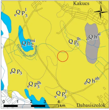
Fig. 1. the geological environment of Kakucs–turján archaeological site.
Legend: eQpl3 – loess;
eQplh3 –loessy sand;
eQhmi2 – lacustrine silt (lime); dQhah –clayey sand; dQhal – aleurite (re-drawn after Gyalog 2005)
27
report on the geoarchaeological survey of Kakucs-turján site
Fig. 2. the magnetometric prospection plan of Kakucs–turján archaeological site with the location of the excavation area and the position of the shallow geological (geoarchaeological) corings.
gauge auger (l = 100 cm; d = 2.5 cm) and an Edelman auger (d = 7 cm). The on-site soil description method followed the prin- ciples of both the Hungarian Soil Classifi- cation System (Stefanovits 1963), and the TIM1 methodology (TIM 1995), which was previously modified and extended in order to be able to describe anthropogenic signs and modification in the soil-sedi- ment environment.
The on-site soil description was carried out based on the following criteria:
• slope/gradient;
• geographic exposure (N, W, S, E);
• vegetation cover;
• colour (based on Munsell Soil Colur Charts 1990);
• texture;
1 TIM = Talajvédelmi Információs és Monitor- ing Rendszer – Methodology of the Soil Informa- tion and Monitoring System of Hungary
• presence of archaeological phenom- enon or particle;
• presence of modern/recent anthropo- genic particle or disturbance;
• moisture status;
• carbonate content (with 10% HCl probe: from 0 to +++);
• concretions;
• root intensity;
• compactness;
• structure.
Samples were collected from the main characteristic stratigraphic units. Labora- tory analyses consisted of the following:
• humus content [H%] (based on Tyurin’s method) (MSZ-08-0452-80)
• total organic carbon content [TOC%]
(Loss on Ignition method) (Buzás 1988;
Faithfull 2002)
• total phosphorus content [Ptotal] (Mur- phy, Riley 1962; Füleky 1983)
28 Ákos pető, Gábor Serlegi, Jakub Niebieszczański, Mateusz Jaeger, Marianna Molnár...
A uppermost humic horizon of the modern soil profile Asz or Ap ploughed layer of the A horizon
B transition horizon between the uppermost humic horizon (A) and the parent material of the modern soil profile
AC transition between A and C horizons (part of the natural soil formation process) BC transition between B and C horizons (part of the natural soil formation process) C parent material
Cals alluvial sandy parent material
Cs sand parent material (fluvio-aeolian origin) Cls loessy-sand parent material
Ccoll/als alluvial sandy parent material with the signs of post-depositional colluvial effects
Ccoll sand or loessy-sand parent material with the signs of colluvial mass movements K1 cultural deposit (layer): grayish-yellowish brown in matrix with the presence of an-
thropogenic inclusions (e.g. daub/charcoal/ceramic fragments/stone fragments etc.) K2 cultural deposit (layer): dark brown in matrix with moderate amount of anthropogenic
inclusions
Kinf cultural deposit(infill of artificially deepened structures (ditch, well/cistern – e.g. Kt-18)
• pH [H2O & KCl] (conductometric method) (MSZ-08-0206/2-78)
• salt content [salt%] (conductometric method) (MSZ-08-0206/2-78)
• carbonate content [CaCO3%] (mea- sured with a Scheibler-type calcimeter) (MSZ-21470/51-83)
• texture coefficient [KA – Arany-type soil texture coefficient] (MSZ-21470/51- 83) (for reference values see Tab. 1).
The soil horizons and layers within the in- dividual profiles were coded with the com- bination of letters and numbers. Individual coring profiles were compiled based on the on-site description as follows:
The y axis of the shallow geological pro- files were compiled based on the absolute height of the corings) and the individual profile descriptions (e.g. relative depth of the layers). Shallow geological cross-sections are displayed based on the EOV Projection Sys-
Table 1. Value ranges for the Arany-type soil texture coefficient.
soil texture Arany-type coefficient value ranges [KA]
coarse sand (cs) < 25
sand (s) 25–30
sandy loam (sl) 30–37
loam/silt (l) 37–42
clayey loam (cl) 42–50
clay (c) 50–60
heavy clay (hc) > 60
tem of Hungary (Unified National Projec- tion). The distance between the corings are displayed on the x axis. The intensity of the anthropogenic disturbance was assessed on a semi-quantitative scale and displayed on
the individual core profiles with red (daub) and black (charcoal) visual signs. The fol- lowing codes were used to denominate the identified layers:
29
report on the geoarchaeological survey of Kakucs-turján site
3. Results and discussion
3.1. The description of the coring profiles of the north-south and east-west cross-sections
In order to examine the soilscape of Kakucs–
Turján archaeological site two coring series were designed. Both the north-south (Fig.
3; KT 01–10; Pető et al. 2015a) and east-west cross-sections (Fig. 4; KT 11–20; Pető et al.
2015a) incorporated coring points beyond the physical (cf. circular ditches observed on the archaeological prospection of the site) boundaries of the settlement. The cor- ing points were set at equal (40m) intervals and avoided the features (e.g. pits), since the goal was not to survey the individual fea- tures, but instead to understand the site’s basic stratigraphy. The area to the north and northwest that was formerly prone to flooding was clearly delineated on the basis of the fluvial layers of sediments observed
in the corings taken there. Archaeological phenomena were not indicated in these areas. On the basis of our current knowl- edge it is possible to state that the settle- ment could not or did not extend to these areas. Remnants of daub and charcoal were found in several profiles (at depth inter- vals between 55–100 cm below the ground level) in the northern part of the site.
These foreign, anthropogenic particles are probably ex situ and were redposited.
The central section of the site is located at the highest point of the examined mi- cro-environment. In the central section of the site there are sand and loessy-sand deposits upon the lower flood plain filled with fluvial layers. This forms a natural,
Fig. 3. the north-south geoarchaeological cross-section of Kakucs- turján archaeological site (after pető et al.
2015a).
30 Ákos pető, Gábor Serlegi, Jakub Niebieszczański, Mateusz Jaeger, Marianna Molnár...
island-like ridge in the landscape, which was most probably optimal for occupa- tion purposes during the Early/Middle Bronze Age. A well-marked change ap- pears in the central area of the site: the particles indicating anthropogenic impact can be observed even on the surface, and their intensity increases from a depth of 50 cm below the ground level. Below the modern soil cover of the site it was not the parent material that appeared, but a layer of anthropogenic deposits (cultural layer) indicated by the code K1. This deposition clearly contains large amounts of daub debris, ceramic remains, ashy micro-lay- ers and particles of charcoal. Below the K1 cultural layer another formation (K2) could be observed that also developed through human activity, or was altered through its impact. On the basis of the corings, this anthropogenic impact is also detected in the area to the south of ditches, and at the same time an eroded soil cover appears on the sandy ridge neighboring the site to the south. In the depression bet- ween the two sand dunes a transported
(ex situ) sedimentation most likely washed here from a higher elevation was observed, which contained anthropogenic particles (remains of ceramics, daub, charcoal and ash) in particularly large amounts.
Based on the observations of the cor- ings taken to the east of the outer ditch encircling the site and the laboratory data currently available – in particular the total phosphorus content measured in the sam- ples taken from here – it seems that the former human activity in this area was not too intensive (Table 2). While the eastern section of the settlement between the two ditches shows some anthropogenic im- pact, the unified cultural layer indicated by the K1 designation observed in the cen- tral section was not detected. This may be related to the fact that this area was (also?) less intensively utilized during its occu- pation in the Bronze Age. Another inter- esting observation was that the sampling locations near the northern inner ditch in the central section also showed very little anthropogenic impact. On the basis of this, the occupation probably had a less
Fig. 4. the east-west geoarchaeological cross-section of Kakucs-
turján archaeological site (after pető et al.
2015a).
31
report on the geoarchaeological survey of Kakucs-turján site intensive impact on this northern half of
the central section. However, in the case of the interior of the central section and the sections indicated in the area of the buildings, the cultural layer that can be separated from the natural soil formations appears clearly. Foreign materials (e.g.
daub fragments) indicating human oc- cupation and disruption were also found in the corings of the northern section, but
their quantity did not come close to that detected in those performed in the cent- ral area of the site. The western sampling locations outside the ditches outlined the lower, formerly flooded areas of the site’s local environment.
The detailed macro-morphological de- scription of K1 and K2 units is given below in the following sub-chapter.
3.2. The description of the corings deepened within the dwelling area
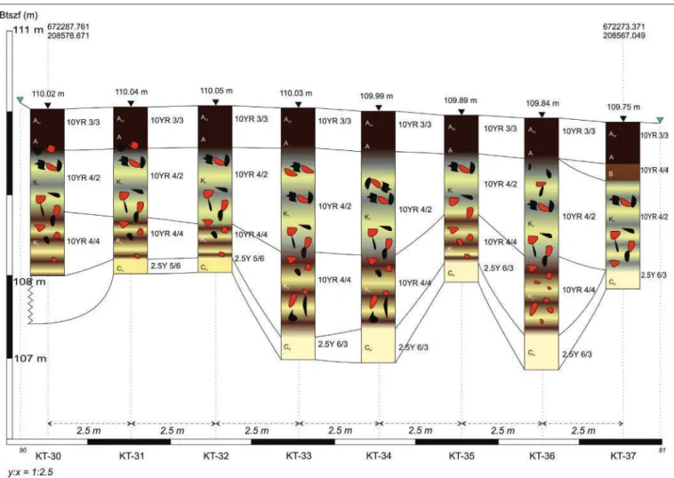
In the central area of the site two series of corings were implemented passing through two Bronze Age buildings (KT-30–37, Fig.
5; Pető et al. 2015a). In the series of corings the individual sampling locations were at 2.5 meter intervals. In general the stratig- raphy of these corings are as follows: the buildings are covered by the modern soil formation of the archaeological site, which consist of a ploughed humic A-horizon. Di- rectly below the modern soil cover an uni- fied anthropogenic deposition designated as the cultural layer K1 was formed. Below the K1 cultural layer there is a layer character- ized by a typically darker K2, which is fol- lowed by the parent material of the site (Cls).
The detailed description of the identi- fied soil horizon, cultural layers/strati- graphic units are given in the followings:
Ap layer: The ploughed layer of the A hori- zon is dark brown (10YR 3/3), its texture can be defined as sandy loam, contains moder- ate amount of carbonates (++); it is slightly compacted due to the effects of soil tillage;
its structure is granular. Nor anthropogenic particles with archaeological/cultural af- filiation, neither modern anthropogenic con- tamination was observed in this layer. The depth of this layer is uniformly 30 cm below ground level.
A horizon: The part of the A horizon, which is untouched by soil tillage works
Table 2. Soil chemical and physical data of representative layers taken at coring point KT-11 and KT-19 at Kakucs–Turján archaeological site (data from Pető et al. 2015a).
Horizon/
Layer sample
depth toC% H% Ptotal CaCo3% pH [H2o] pH [KCl] salt% KA
[cm] ppm
Kt-11
Ap 0–25 n.a. n.a. n.a. n.a. n.a. n.a. n.a. n.a.
A 25–60 3.0 1.7 276 5 7.6 7.2 0.01 28
AB 60–90 1.9 1.1 237 11 8.0 7.5 0.01 28
B 90–120 1.2 0.7 265 14 8.1 7.5 0.01 26
Cls 120–16 0.3 0.2 295 26 8.4 7.9 0.01 31
Kt-19
Ap 0–25 2.6 1.5 374 10 7.9 7.3 0.01 26
A 25–40 2.0 1.2 321 13 7.9 7.5 0.01 26
B 40–60 1.2 0.7 236 20 8.0 7.8 0.01 24
Cs 60–80 0.7 0.4 180 30 8.2 7.7 0.01 30
Cals 80–100 0.4 0.2 161 22 8.4 7.7 0.01 37
32 Ákos pető, Gábor Serlegi, Jakub Niebieszczański, Mateusz Jaeger, Marianna Molnár...
show similar properties. Dark brown colour (10YR 3/3), sandy loam texture, moderate amount of carbonates (++), less compaction and granular structure.
The relative depth of this horizon varies between 45 to 60 cm-s. Anthropogenic particles with archaeological/cultural af- filiation could have only been observed in a few cases (e.g. small and strongly weath- ered particles of daub). These are acknowl- edged as deriving from the cultural layers beyond the modern humic soil cover.
K1 layer: This anthropogenic layer is situated beyond the modern soil cover and in most of the cases the transition between the natural soil cover and this layer is gradual in colour and in texture, however the occurrence of anthropogen- ic particles and disturbance defines the boundary between the culturally affected and natural formations. The matrix of K1 is grayish yellow (10YR 4/2), however the layer is multicoloured and its colour varies on a broad scale depending on the type and density of anthropogenic mate-
rial that is located at the coring point. Its texture is sandy loam, containing low or moderate amount of carbonates (from 0 to ++). Typically daub and charcoal frag- ments appear in this layer, however their relative density varies. This layer is situ- ated between the relative depths of 60 and 160 cm-s, its thickness varies, but no extreme observations were recorded. In general, and as discussed previously (Pető et al. 2015a; Pető et al. 2015b), the K1 layer is thought to be the complex of the rub- ble layer and the debris that accumulated during the inhabitation of the site. In this context the variance in the relative density of the anthropogenic material is accept- able, since the homogenous distribution of these material cannot be imagined within such human-induced contexts.
K2 layer: This anthropogenic layer is situated beyond K1 within the central part of the site. This layer is brown (10YR 4/4) in colour, however depending on the in- tensity of anthropogenic effects its colour might vary; its texture is sandy loam, con-
Fig. 5. the geoarchaeological cross-section of the inner ditch of Kakucs–
turján archaeological site (after pető et al.
2016).
33
report on the geoarchaeological survey of Kakucs-turján site tains low or moderate amount of carbon-
ates (from 0 to ++). Tangible anthropoge- nic material was observed in more pro- files, however the signs of soil disturbance was a general key trait of this layer. As dis- cussed earlier, the K2 layer is thought to be the remain of the paleo humus horizon on which the inhabitation of the site occurred during the EBA/MBA period. Based on its condition, this layer can be less or more intensively disturbed. In the light of these observation it can be anticipated that the occupation of the site appeared on this level, however the living process of the in- habitant diversely disturbed the original humus horizon and this disturbance also resulted in mixing anthropogenic parti- cles (e.g. daub, charcoal, stone, bone etc.) in the matrix of this soil material.
Parent material: The parent material within the dwelling area, which is the highest altitude surface of the site is domi- nantly loessy sand (Cls), which is a dull yel- low (2.5Y 6/3), sandy loam textured, loose sediment, which does not contain any an- thropogenic material.
During the examination of the build- ings situated parallel to one another, an es- sentially identical stratigraphy was found, although differences in thickness could be observed. At certain points the K2cultur-
al layer below the K1 thickens significantly and shows a specific, visible stratification.
In some places the lowest points of the anthropogenic K1 and K2 cultural layers is close to 3 meters below the surface (see KT-33 and KT-34 on Fig. 5). This is more than 1 meter deeper than the same lev- els in the neighbouring two core samples sunk into what was also presumed to be the interiors of the buildings (Fig. 5). The sub-stratigraphy of these coring points were found to be similar.
K1 showed the following stratigraphy:
• 50–80 cm: brown, sandy textured natu- ral soil formation;
• 80–100 cm: pale brown, homogenous layer;
• 100–160 cm: disturbed layer with high amount of daub fragments and varied in colour;
K2 showed the following stratigraphy:
• 160–220 cm: anthropogenic sediment with daub fragments, charcoal remains and humus lenses;
• 220–250 cm: yellowish sandy layer;
• 250–280 cm: brownish yellow layer showing parallel carbonate concretion due to alternating vertical water move- ments, such as periodical leaching and infiltration.
3.3. The description of the ditch structures
The outer ditch: A shallow geological cor- ing series was designed to map the stratigra- phy, depth and geological properties of the outer ditch. A coring series consisting of sev- en coring points (KT-211–251, Fig. 6; Pető et al. 2016) aimed at providing a detailed view of the cross-section of this ditch part.
The uppermost soil cover is homogenous and represents the modern, Chernozem- like soil cover of the archaeological site. No significant differences were found between the morphological features of the recent soil cover above the ditch and the soil cover of the entire site in general (Pető et al. 2016).
The infill sediment of the ditch (Kinf) is present in differing thickness throughout the cross-section (Fig. 6). Kinf was not iden- tified at KT-211 and KT-251, which means
that the coring series reached the border of the ditch. The Kinf shows its thickest facies at KT-21 and KT-24 and draws up a V-like pattern indicating the original ditch shape.
The colour of the Kinf varied between brownish black (10YR 2/2) and yellow- ish gray (2.5Y 4/1–6/1), and consisted of two types of sub-layers. Very fine lami- nations were identified within this sedi- ment, which underline the gradual refill of the ditch across a longer time period. The alternation of darker, more humic, and brighter, sandy fractions point to cyclic re- fill with different materials. Besides these laminations, thicker, turbated and mixed- up blocks of clays and silty sediments also occur within the Kinf. These laminations
34 Ákos pető, Gábor Serlegi, Jakub Niebieszczański, Mateusz Jaeger, Marianna Molnár...
and the bigger flecks of clayey blocks all represent a stage of the ditch development.
Based on these observations, it is difficult the determine whether the ditch was al- ways filled with water or if it only held wa- ter periodically. The fine lamination points to a sedimentation process that took place in a standing, still water environment, but in opposition to that, the thicker and tur- bated parts point to “terrestrial” sedimen- tation.
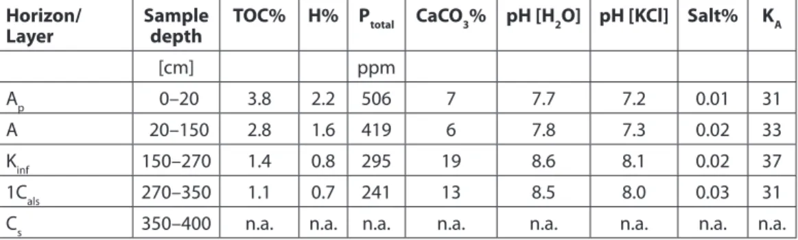
Samples from each representative layer were taken at coring point KT-21 (Table 3).
Values for the ploughed layer (Ap; 0–20 cm) and the A-horizon (20–150 cm) are in accordance with Chernozem-like soils de- veloped on a sandy parent material. In this regard, any difference to the other parts of the site cannot be stated. It is interesting to note that the results of the Kinf in general do not represent a high organic matter in- put. All organic matter indicators, such as
Table 3. Soil chemical and physical data of representative layers taken at coring point KT-21 within the outer ditch of the Kakucs–Turján archaeological site (data from Pető et al. 2016).
Horizon/
Layer sample
depth toC% H% Ptotal CaCo3% pH [H2o] pH [KCl] salt% KA
[cm] ppm
Ap 0–20 3.8 2.2 506 7 7.7 7.2 0.01 31
A 20–150 2.8 1.6 419 6 7.8 7.3 0.02 33
Kinf 150–270 1.4 0.8 295 19 8.6 8.1 0.02 37
1Cals 270–350 1.1 0.7 241 13 8.5 8.0 0.03 31
Cs 350–400 n.a. n.a. n.a. n.a. n.a. n.a. n.a. n.a.
Fig. 6. the geoarchaeological cross-section of the outer ditch of Kakucs–
turján archaeological site (after pető et al.
2016).
35
report on the geoarchaeological survey of Kakucs-turján site the TOC%, Ptotal and H%, show quite low
values (Table 3), which might refer to the fact that settlement waste was not depos- ited in the ditch. In other words, the ditch was kept “clean”.
The entire ditch was cut in a greyish yel- low (2.5Y 7/2) sediment, which – accord- ing to the on-site observations – showed signs of stagnant water. Manganese and iron flecks (cf. gley) and even smaller con- cretions could have been observed in this layer, which served as the bedding for the ditch. Based upon these observations, it can be imagined that this sediment acted as a water resistant, or at least periodically wa- ter resistant, bedrock for the ditch. This is somewhat controversial in light of the value of the texture coefficient (KA = 31; Table 3) of this layer, because that value indicates sandy loam instead of a hard clay. It must be stressed, however, that a finer clay frac- tion, which might serve the aims of water retention within such sediments, cannot be seen in or measured by the KA coefficient.
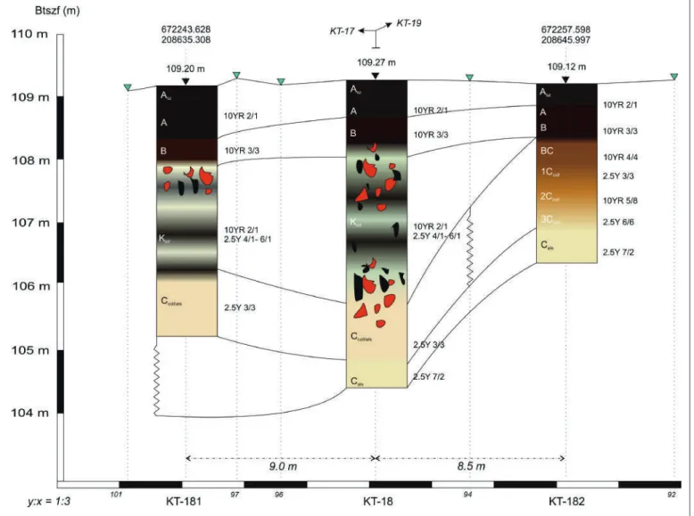
The cistern-like feature: In the northern section of the site, the survey detected a cir- cular anomaly measuring approximately 12 m in diameter and distinguished by marked- ly elevated magnetic values. Its nature was examined by means of a dense network of drillings, which exposed the subsurface structure of the sediments making up the feature (see Niebieszczański et al. Geoar- chaeological and non-invasive investiga- tions of the site and its surroundings: Figs 6, 12; in this volume). Coring point KT-18 was positioned in the very middle of this anomaly to map the depth of this possible cistern or retention tank feature. Similar to the other coring points, the uppermost 1 meter consisted of the modern soil cover.
Below that, we identified a 320 cm thick in- fill of sediment layer series (Kinf), situated in 100–420 cm relative depth. The follow- ing stratigraphy could be observed (after Pető et al. 2016) (Fig. 7):
• 100–130 cm: dark brown (10YR 3/3), crumbly structured, clayey silt, high
Fig. 7. the geoarchaeological cross-section of the round-shaped archaeological feature at Kakucs–turján archaeological site (after pető et al. 2016).
36 Ákos pető, Gábor Serlegi, Jakub Niebieszczański, Mateusz Jaeger, Marianna Molnár...
concentrations of charcoal fragments;
• 130–180 cm: pale brown/yellowish gray (2.5Y 4/1), homogenous matrix, clayey silt;
• 180–260 cm: yellowish gray (2.5Y 6/1), sand, few daub and charcoal fragments;
• 260–300 cm: dark brown (10YR 3/3), humic, high intensity of charcoal, fine laminations composed of grey and yel- lowish coarse sand;
• 300–320 cm: dark brown (10YR 3/3), homogenous matrix; clayey silt, daub and charcoal;
• 320–340 cm: pale brown/yellowish grey (2.5Y 4/1), homogenous matrix; sand, daub and charcoal;
• 340–370 cm: dark brown (10YR 3/3), homogenous matrix; clayey silt, daub and charcoal;
• 370–420 cm: yellowish gray (2.5Y 6/1), loose sand, only few anthropogenic particles (daub, charcoal), humic inclu- sions.
As it is shown by the detailed description above, the Kinf shows a certain range of variability in texture, colour, and the in- tensity of anthropogenic particles. Similar to the examined outer ditch section, the fine laminations observed in the layer se- ries also refer to sedimentation in stand- ing water (Fig. 8). The refill process of this feature most probably occurred in sepa- rate steps; this is what the easily separable layers refer to.
A sample taken for the representation of the entire layer shows a clay texture (KA
= 47), and high organic matter input with- in this layer (TOC% = 4.0). Within the anthropogenic indicators, only the total phosphorus content gave a low value (Ptotal
= 468 ppm) (Table 4). This combination – similar to the case of the ditches – might refer to the fact that no waste material was deposited here. The high TOC% and H%
values might come from the erosion of the surface soil material. The embedding sedi-
Fig. 8. A detail of the Kinf with laminations in the
core profile deepened within the round- shaped, cistern-like feature (coring point:
Kt-18 at 260–300 cm relative depth).
37
report on the geoarchaeological survey of Kakucs-turján site Table 4. Soil chemical and physical data of representative layers taken at coring point KT-18 within the outer ditch of the Kakucs–Turján archaeological site (data from Pető et al. 2016).
Horizon/
Layer sample
depth toC% H% Ptotal CaCo3% pH [H2o] pH [KCl] salt% KA
[cm] ppm
Ap 0–25 n.a. n.a. n.a. n.a. n.a. n.a. n.a. n.a.
A 25–60 3.1 1.8 324 7 7.8 7.3 0.01 26
B 60–100 3.0 1.7 1230 22 8.2 7.8 0.01 36
Kinf 100–420 4.0 2.3 468 24 8.3 7.9 0.02 47
Ccoll/als 420–450 n.a. n.a. n.a. n.a. n.a. n.a. n.a. n.a.
Cals 450–470 n.a. n.a. n.a. n.a. n.a. n.a. n.a. n.a.
ment of this feature shows similar morpho- logical traits (especially gley marks in the form of manganese and iron flecks) as the sediment embedding in the ditches did.
In summary, we might conclude that the feature is a man-made hollow with a distinct boundary, tentatively inter- preted as a kind of retention tank (e.g.
a cistern at the junction of the surround- ing ditches?). It should be noted that the feature in question is connected with the system of trenches surrounding the settle- ment. Assuming that water was pres- ent in the trenches/ditches, the hollow may have been a kind of facility to cre- ate a hydrological depression, thanks to which the ditch would be filled with wa- ter from a nearby river or surface waters, and then flow down towards the tank. In contrast, if no watercourse had existed in the proximity of the site, it should be as- sumed that the hollow functioned as a hy- drogeological depression which gathered water from various underground levels. In either case, the tank should be interpreted
as a singular, innovative hydrogeological solution whose purpose was to supply and maintain a certain water level in the ditch which surrounded the settlements.
The inner ditch: The geoarchaeologi- cal characteristics of the inner ditch sur- rounding the nearly round nucleus of the site was investigated through five corings (KT-38–42; see Niebieszczański et al. Geo- archaeological and non-invasive investi- gations of the site and its surroundings:
Fig. 12; in this volume) (Fig. 9; Pető et al.
2016). Similarly to the outer ditch, the in- dividual sampling locations were placed in two meter interval. On the basis of the corings it was possible to reconstruct the deepest point of the ditch at 300–350 cm relative depth (Table 5).
The morphological features identified in the undisturbed core samples suggest the presence of stagnant water, and the fine laminated structure detected in sev- eral locations indicates gradual sedimen- tation. Based on the preliminary results, it is anticipated that there might have been
Table 5. Soil chemical and physical data of representative layers taken at coring point KT-39 within the inner ditch of the Kakucs–Turján archaeological site (data from Pető et al. 2016).
Horizon/
Layer sample
depth toC% H% Ptotal CaCo3% pH [H2o] pH [KCl] salt% KA
[cm] ppm
Ap 0–30 n.a. n.a. n.a. n.a. n.a. n.a. n.a. n.a.
A 30–60 3.7 2.2 323 10 7.9 7.5 0.01 32
B 60–100 4.0 2.3 383 15 8.0 7.7 0.01 32
K1 100–200 2.2 1.1 236 16 8.3 7.6 0.01 29
1Kinf 200–300 2.8 1.6 1234 19 8.6 8.0 0.02 42
Cals 300–370 2.3 1.3 403 17 8.6 8.1 0.03 41
Cs 370–400 n.a n.a n.a n.a n.a n.a n.a n.a
38 Ákos pető, Gábor Serlegi, Jakub Niebieszczański, Mateusz Jaeger, Marianna Molnár...
different periods of ditch refill, but it is hard to determine whether all of these occurred after the site was abandoned or during the life of the settlement. Based solely upon the corings, we cannot de- fine signs of conscious ditch clearing. The laminations might have occurred while the site was occupied, but might also rep- resent refill periods after site abandon- ment. From a geoarchaeological point of view, the different types of morphologi- cal features (fine laminations vs. bigger blocks of humic material) refer to differ- ent sedimentation periods, linked to dif- ferent ditch conditions. In particular, fine laminations might develop if the ditch is filled with water, while the bigger blocks of soil matter could have entered the ditch during times that it experienced drier con- ditions. It must be stressed, however, that these hypotheses are based on the results of macromorphological analysis/observa- tions of the corings.
It has to be stressed that a careful and thorough analysis of the geophysical im- age does demonstrate that at a certain point the structure of the anomaly is in-
terrupted. For this reason, one should ex- ercise caution in interpreting trench-like features as a continuous ditch system. It is nevertheless possible that individual ditch sections functioned independently, as sep- arate structures. As an addition to that, we have found that the rubble layer of the settlement (K1 and K2; see description ear- lier in the text) can be found on top of the infill of the inner ditch (KT-38 to KT-42;
Fig. 9) and is missing from the top of the outer ditch. This might point to the fact that the tripartite organisation of the settlement is a result of its expansion, and represents a development in time. Two hypotheses can be based on this. Firstly, that the settlement expanded over the inner ditch with time, and in this case the inner ditch was partly filled during the life of the settlement. The second option is related to the taphonomy of the site. After the site was abandoned, the rubble destruction layer (K1) eroded and was re-deposited on a wider area than it was originally distributed.
The immediate neighbourhood of the ditches is interesting as well, as the lat- ter features are accompanied by strips of
Fig. 9. the geoarchaeological cross-section of the dwelling area (buildings) located in the centre part of Kakucs-turján archaeological site (after pető et al. 2015a).
39
report on the geoarchaeological survey of Kakucs-turján site ground, approximately 7 meters wide, lo-
cated on the inner side of the settlement, which the geophysical image shows to be devoid of magnetic anomalies. Geo- archaeological corings and analyses of samples demonstrated that these areas are anthropogenic in terms of genetic and sedimentological factors. Coring point KT-42 falls within this range (Fig. 2). The morphological features of this coring give a transition between the signs we have ob- served in the case of the ditches and the signs of the central part of the site. The stratigraphy of this core is complex. Below the modern soil profile, layers similar to the ditch infill sediment types occurred.
We identified three slightly different lay- ers: 1Kinf, 2Kinf, 3Kinf.
The sediment type encoded as 1Kinf is the same as the one we described for the outer ditch section. Below that, 2Kinf is a 150 cm thick layer (situated between 170–280 cm relative depth), which is light yellow (2.5Y 7/3), and has slightly laminat- ed sediment, which is followed by a black (anthropogenic?) layer encoded as 3Kinf (situated between 280–320 cm relative depth). All three layers can be identified as ditch infills, although this coring rep- resents a transition between the ditch and the central part of the settlement. Thus, these layers do not show well-defined lam- inations and show more intensive distur- bance, which can be related to the fact that KT-42 represents the slope of the ditch.
Acknowledgement
This work was partly supported by the Já- nos Bolyai Research Scholarship
of the Hungarian Academy of Sciences and the National
Research, Development and Innovation Office (grant number PD_124607).
References
BUZÁS I.
1988 Talaj- és agrokémiai vizsgálati mód- szerkönyv 2. Budapest.
FAITHFULL N. T.
2002 Methods in agricultural chemical analy- sis: a practical handbook. Oxford.
FÜLEKY G.
1983 Fontosabb hazai talajtípusok foszforál- lapota. Agrokémia és Talajtan 32 (1-2), 7–30.
MSZ-08-0206/2-78
1978 A talaj egyes kémiai tulajdonságainak vizsgálata. Laboratóriumi vizsgálatok (pH érték, szódában kifejezett fenoftalein lúgo- sság, vízben oldható összes só, hidrolitos (y1 érték) és kicserélődési aciditás (y2 érték).
Magyar Szabványügyi Hivatal, Budapest MSZH-Nyomda, 12.
MSZ-08-0452-80
1980 Nagyteljesítményű műszersorok al- kalmazása talajvizsgálatokban. A talaj szerves szén tartalmának meghatározása Contiflo műszersoron. Magyar Szab- ványügyi Hivatal, Budapest MSZH-Nyo- mda, 7.
MSZ-21470/51-83
1983 Környezetvédelmi talajvizsgálatok. A ta- laj kötöttségének meghatározása. Magyar Szabványügyi Hivatal, Budapest MSZH- Nyomda, 3.
MURPHY J., RILEY J. P.
1962 A modified single solution method for the determination of phosphate in natu- ral waters. Analytica Chimica Acta 27, 31–36.
MUNSELL SOIL COLOUR CHARTS
1990 Soil Survey Manual – U.S. Dept. Agricul- ture Handbook – 18.
PETŐ Á., SERLEGI G., KRAUSZ E., JAEGER M., KULCSÁR G.
2015a Régészeti talajtani megfigyelések “Ka- kucs–Turján mögött” bronzkori lelőhelyen I. [Geoarchaeological observations at the Bronze Age site of Kakucs–Turján mögött I.] Agrokémia és Talajtan. 64(1). 219–237.
2015b Geoarchaeological survey of Bronze Age fortified settlements. Kakucs Archaeo- logical Expedition - KEX 2. Hungarian Archaeology. Summer, 3. 1–10.
2016 Régészeti talajtani megfigyelések “Kakucs–
Turján mögött” bronzkori lelőhelyen II.:
Az árokrendszer. [Geoarchaeological ob- servations at the Bronze Age site
„Kakucs–Turján mögött” II.: The hydro- logical system]. Agrokémia és Talajtan 65(2), 225–242.
STEFANOVITS P.
1963 Magyarország talajai. (Soils of Hungary).
Budapest.
TIM 1995 Talajvédelmi Információs és Monito- ring Rendszer 1. kötet: Módszertan.
Földművelésügyi Minisztérium, Növé- nyvédelmi és Agrár–környezetgazdál- kodási Főosztály, Budapest.