2018
2018
communicationes archÆologicÆ
hungariÆ 2018
magyar nemzeti múzeum Budapest 2020
Főszerkesztő FoDor istVÁn
Szerkesztő sZenthe gergelY
A szerkesztőbizottság tagjai
BÁrÁnY annamÁria, t. BirÓ Katalin, lÁng orsolYa morDoVin maXim, sZathmÁri ilDiKÓ, tarBaY JÁnos gÁBor
Szerkesztőség
magyar nemzeti múzeum régészeti tár h-1088, Budapest, múzeum Krt. 14–16.
Szakmai lektorok
Pamela J. Cross, Delbó Gabriella, Mordovin Maxim, Pásztókai-Szeőke Judit, Szenthe Gergely, Szőke Béla Miklós, Tarbay János Gábor
© A szerzők és a Magyar Nemzeti Múzeum
minden jog fenntartva. Jelen kötetet, illetve annak részeit tilos reprodukálni, adatrögzítő rendszerben tárolni, bármilyen formában vagy eszközzel közölni
a magyar nemzeti múzeum engedélye nélkül.
hu issn 0231-133X
Felelős kiadó Varga Benedek főigazgató
tartalom – inDeX
Polett Kósa
Baks-Temetőpart. Analysis of a Gáva-ceramic style
mega-settlement ... 5 Baks-Temetőpart. Egy „mega-település” elemzése
a Gáva kerámiastílus időszakából ... 86 annamária Bárány– istván Vörös
Iron Age Venetian Horse of Sopron-Krautacker (NW Hungary) .... 89 Venét ló Sopron-Krautacker vaskori lelőhelyről ... 106 Béla Santa
romanization then and now. a brief survey of the evolution
of interpretations of cultural change in the Roman Empire ... 109 Romanizáció hajdan és ma. A Római Birodalomban
végbement kultúraváltást tárgyaló interpretaciók
fejlődésének rövid áttekintése ... 124 Zsófia Masek
A Sarmatian-period ceramic tripod from Rákóczifalva ... 125 Szarmata tripos Rákóczifalváról ... 140 Soós eszter
Bepecsételt díszítésű kerámia a magyarországi Przeworsk
településeken: a „Bereg-kultúra” értelmezése ... 143 Stamped pottery from the settlements of the Przeworsk culture
in Hungary: A critical look at the “Bereg culture” ... 166 Garam Éva
Tausírozott, fogazott és poncolt szalagfonatos ötvöstárgyak
a zamárdi avar kori temetőben ... 169 metalwork with metal-inlaid, Zahnschnitt and punched
interlace designs in the Avar-period cemetery of Zamárdi ... 187 Gergely Katalin
avar kor végi település Északkelet-magyarországon:
Nagykálló-Harangod ... 189 Endawarenzeitliche Siedlung in Nordost-Ungarn:
Nagykálló-Harangod (Komitat Szabolcs-Szatmár-Bereg) ... 211 tomáš König
The topography of high medieval Nitra. New data concerning
the topography of medieval towns in slovakia ... 213 Az Árpád-kori Nyitra topográfiája. Adalékok a középkori városok topográfiájához Szlovákia területén ... 223 Topografia vrcholnostredovekej Nitry. Príspevok k topografii stredo- vekých miest na Slovensku ... 224
Mojzsesz Volodimir
a gerényi körtemplom ... 225 The rotunda in Horyany ... 247 P. Horváth Viktória
Középkori kések, olló és sarló a pesti Duna-partról ... 249 Knives, scissors and a sickle from the coast of the Danube
in Budapest ... 271
KöZlemÉnYeK Juhász lajos
ii. Justinus follisa Aquincumból ... 273
213
The “Lady of Borjád”
2018
The importance of the town of Nitra in the High Middle Ages is well documented from the perspec- tive of historical research. However, archaeological excavations over the long-term, especially those of the cemeteries (Fusek 2008), document the continual development of the local settlement-network begin- ning in the Great Moravian period. As the results of recent archaeological research also suggest, it is pos- sible to assume that Nitra was not even affected by the military events connected with the establishment of power by the Old Hungarian tribal union in the Carpathian Basin at the beginning of the 10th century (König 2016). In this case, it is also possible to con- sider that not only did this involve the continuity of settlement, but also, in a certain form, a continuation of its function as an administrative centre.
Natural conditions and long-distance routes The localisation of medieval towns was fundamen- tally linked to trade routes. However, the course
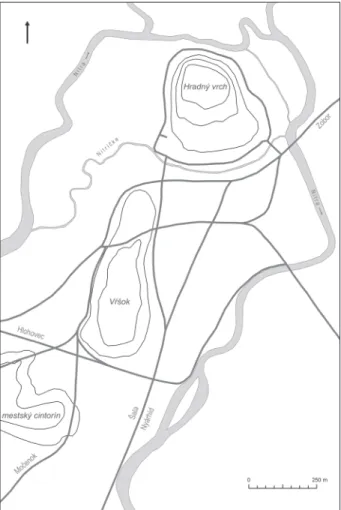
of routes, especially in the distant past, was most heavily influenced by the structure of the terrain and watercourses, both of which represent obsta- cles. Nitra has no defined market square nor regu- lar layout and a respective system of streets. There- fore, it must be assumed from the outset that as a town growing out of the continuity of settlement, it had a topography that was heavily affected by natu- ral conditions and the trade routes that ran through the town and which became the skeleton of its later network of streets (Fig. 1).
The geomorphological structure of Nitra is dom- inated to this day by three elevated positions – Cas- tle Hill, Summit (Vŕšok) and the town cemetery – natural formations, around which the main branch of the Nitra River flows. In the past, Castle Hill was completely cut off from the surrounding space by a stream named the Little Nitra (Nitrička). How- ever, during the first half of the 20th century, major changes were made in Nitra, including the filling of the Little Nitra, the relocation of the main riverbed Tomáš König
THE TOPOGRAPHY OF HIGH MEDIEVAL NITRA NEw DATA CONCERNING THE TOPOGRAPHY
OF MEDIEVAL TOwNs IN sLOVAkIA
1Nitra was one of the most important castle towns in the Kingdom of Hungary during the High Middle Ages between the 11th and 13th centuries. The results of existing research have not produced a uniform image of the town’s topography. Opinions among scholars differ especially concerning the location and extension of the extramural settlement. Archaeological excavations at the Tržnica and Mlyny locations raise the pos- sibility that the extension of the extramural settlement was larger than the area later enclosed by the town walls. The reason behind such reduction could have been the decline of the town as a result of the devastat- ing consequences of the Tatar invasion of Hungary in 1241.
Nyitra az Árpád-kori Magyar Királyság egyik legfontosabb ispánsági vára volt a 11. és a 13. század között.
Az eddigi kutatások eredményei nem szolgáltatnak egységes képet a város topográfiájáról. A szakemberek között a vélemények megoszlanak a váralja település helyéről és kiterjedéséről. A Vásártér (Tržnica) és a Malmok (Mlyny) lelőhelyeken végzett feltárások nyomán feltételezhetjük, hogy a váralja település nagyobb lehetett, mint a későbbiekben a városfal által bekerített terület. A város méretének csökkenése mögött nagy valószínűség szerint az 1241. évi tatárjárást követő hanyatlás állhat.
keywords: Nitra; 11th–13th century; castle town; topography; extramural settlement; Tatar invasion kulcsszavak: Nyitra; 11–13. század; ispánsági vár; topográfia; váralja település; tatárjárás
214 Tomáš König
of the Nitra and the filling of its side branch that flowed through the Mlyny location (Březinová–
Samuel 2007, 61; König et al. 2014, 21–23).
with respect to the long-distance routes, sev- eral of superregional importance met up in Nitra.
According to the testimony of written sources, a route from Hlohovec ran from the northwest to Nitra (connecting probably somewhere before Nit- ra with a trail from Šintava), from the southwest a route from Šaľa (Lukačka 2002, 209–210). Both of these routes secured communication with prominent crossing points and toll collection locations on the lower part of the Váh River (Jamrichová 1997, 65–
68). After meeting in Nitra, the long-distance routes diverged in different directions. A northward route ran to the peak of Mt. Zobor, while the other ran southward to Nyárhíd (Lukačka 2002, 209–210).
The content of a letter of the Nitra Chapter from 1247 states that the route from Šaľa passed through Cabaj-Čápor (CDSl 2, 191, no. 272). But as con- cerns the street network of Nitra, this route likely entered the town already joined with the aforemen-
tioned road to Nyárhíd. The document also mentions that a route of local importance also ran from the southwest to Nitra, thus creating a direct link with Močenok (CDSl 2, 191, no. 272).
Another source that can document the presence of routes and streets is archaeological finds. In ad- dition to the loosely dated medieval road to Castle Hill (Samuel–Bednár 2012, 199–200), sections of medieval streets with a paved surface are also known from two other locations in Nitra. Investi- gated in Mlynská street (Ruttkay 2006, 170), the first of these corresponded to the horizon with set- tlement finds datable to the 13th–15th century, and it seems that the street followed the former town walls.
A street with the same direction is also known in this area of the town from old maps (Březinová–
Samuel 2007, 46–47, Fig. 69). The second street, uncovered in Nitra-Mlyny, was constructed some- time in the second half of the 13th century and was not used for longer than fifty years (König et al.
2014, 90). Given its location and direction, its con- nection to the modern street network presented on the available old maps is not traceable.
Description of the town in the written sources As concerns a description of the town preserved in written sources, there are only three documents re- lated to the studied period. The first is the Chronica Boemorum, which records a military event from the year 1109 (Chronica Boemorum, 194–195, III/26).
This source clearly indicates that an unfortified ex- tramural settlement (suburbium) also belonged to Nitra Castle (urbs Nitra), which was protected by a wall. The second document is a report from the Ni- tra Chapter from 1247 in which the line of the town border is described (CDsl 2, 191–192, no. 272). In addition to the town itself (civitas Nitriensis), this report also describes the location of some of its in- dividual spatial units (terra ecclesiae Nitriensis and suburbium). A site named castrum Iudaeorum is also mentioned, albeit without further explanation.
Finally, the third important document for the topog- raphy of Nitra, despite already dating to the begin- ning of the Late Middle Ages, is a charter issued by Charles Robert in 1313 (RDsl 1, 485–486, no.
1142) recording the existence of town fortifications (menia et turres civitatis Nitriensis).
History of research
All data on the topography of high medieval Nitra come from modern research, with the first phase Fig. 1 Nitra, reconstruction of the medieval street network
1. kép Nyitra, a középkori utcahálózat rekonstrukciója
The topography of high medieval Nitra 215 composed of works by experts from the historical
sciences. A key source for them was the aforemen- tioned letter of the Nitra Chapter from 1247. Based on its interpretation, V. Šmilauer (Šmilauer 1932, 101, 103–104), a Czech linguist, noted on the map of the relevant section of the Nitra River region that the town space was lined on the north by Little Nitra stream, while also including land along the left bank of the Nitra River. The site designated in the document as castrum Iudaeorum was the same as the formerly separate village of Párovce, in the Early Modern period a Jewish settlement situated at the western edge of Nitra.
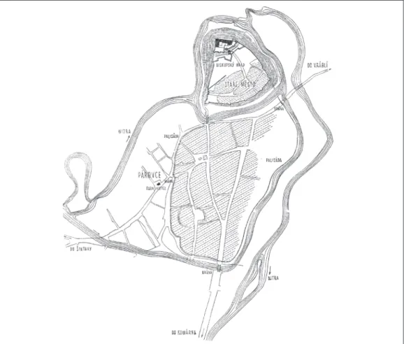
The author of the first topographical plan of historical Nitra (Fig. 2) was V. Mencl, a Czech art historian and expert in medieval architecture. Al- though it is not known what exactly led him to such a conviction, he believed that Nitra in the High Mid- dle Ages was limited to Castle Hill (Mencl 1938, 57–60). At that time, the area of the present day Old Town was presumed to be occupied only by sepa- rate settlements. Mencl’s plan, likely based on the heavily stylised Early Modern renderings of the
town with which he worked, features a rather un- realistic reconstruction of the Nitra River branches.
Albeit without graphic representation, slovak historian R. Marsina produced a fundamentally dif- ferent view of the topography of high medieval Nitra (Marsina 1977, 34, 36). Based on the document of the Nitra Chapter from 1247, Marsina claimed the existence of multiple town parts with different legal status. On Castle Hill, he distinguished the castle and outer bailey (later called the Upper Town), both of which were to have been fortified. According to Marsina, a legally and spatially separated part, later known as ‘Podhradie’ (extramural settlement), al- ready existed in this period at the base of Castle Hill, approximately in the area of today’s Podzámská street. Neither was it part of Nitra nor property be- longing to the Nitra Chapter (terra ecclesiae Nitri- ensis), which was located roughly in the area of the modern Vikárská and Ďurková streets. The actual extramural settlement (later known as the Lower Town) was to have been designated on the docu- ment as suburbium and belonged to the population, which was granted privileges in 1248.
Fig. 2 Nitra, topographical plan of the historical town after V. Mencl (Mencl 1938, 58, Fig. 6) 2. kép Nyitra, a történeti városmag topográfiája V. Mencl alapján (Mencl 1938, 58, Fig. 6)
216 Tomáš König The second phase of activities aimed at recognis-
ing the historical topography of Nitra then belonged primarily to researchers in the field of archaeolo- gy. Referring continually (and surprisingly) to the charter of Bela IV from 1248 (CDsl 2, 208–209, no. 298), A. Ruttkay outlined a modified concept of the topography of high medieval Nitra in multiple studies (Ruttkay 1995; Ruttkay 1996; Ruttkay 1999). In his written description (Ruttkay 1999, 246), which does not fully correspond to the graphic depiction (Fig. 3), Ruttkay stated that the historical designation suburbium can be linked to the base of Castle Hill, to a narrow unfortified space north of the Little Nitra. He equated the castrum Iudaeorum location with the Summit (Vŕšok) site, suggest- ing that it could have been a fortified settlement.
As confirmation of this assumption, Ruttkay pre- sented the find of the remnants of three stone side towers built at intervals along the west edge of the summit (Ruttkay 1999, 248). He equated the space northeast of the summit position with the designation civitas.
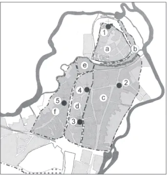
A. Ruttkay’s topography concept, was soon in principle adopted by J. Ruttkayová and M. Ruttkay
(Ruttkayová–Ruttkay 1997, 104, 111), albeit with a new graphic processing (Fig. 4). They con- nected the position of the summit on the plan with Párovce and equated them with the castrum Iudae- orum location.
P. Bednár (Bednár 2002) presented the topog- raphy of high medieval Nitra in recent years essen- tially in the spirit of A. Ruttkay’s concept. However, he also created a new plan (Fig. 5) with a number of important modifications. He demarcated a space belonging to the Nitra Chapter in the north-western part of the town south of the Little Nitra. In agree- ment with the written description of A. Ruttkay (Ruttkay 1999, 246), he reduced the space identi- fied as the suburbium to a narrow strip at the base of Castle Hill. He expanded the scope of the settlement related to the term civitas toward the south up to the level of the modern Štúrova street.
Although scholars from the field of archaeology became involved in the issue of Nitra’s topography, their efforts have not been reflected in works by historians. The younger generation was represented by J. Lukačka, whose publications (also exclusive- ly with written descriptions) build on the work of R. Marsina. He equated the castrum Iudaeorum with a separate settlement with the parish Church of Fig. 3 Nitra, topographical plan of the high medieval
town after A. Ruttkay (Ruttkay 1999, 247, Fig. 9) 3. kép Nyitra, az Árpád-kori város topográfiája A.
Ruttkay alapján (Ruttkay 1999, 247, Fig. 9)
Fig. 4 Nitra, topographical plan of the high medieval town after J. Ruttkayová and M. Ruttkay (Ruttkayová–
Ruttkay 1997, 104, Fig. 1)
4. kép Nyitra, az Árpád-kori város topográfiája J. Ruttkayová és M. Ruttkay alapján (Ruttkayová–
Ruttkay 1997, 104, Fig. 1)
The topography of high medieval Nitra 217 St. Stephen the King, specifically with probably a
considerably significant Jewish community, likely quite large (Lukačka 1998, 160; Lukačka 2010, 284–285).2 He also addressed an assumption, albeit undocumented with sources, that the extramural set- tlement of the town of Nitra (later the Lower Town) expanded toward the south all the way to the Tržnica location (Lukačka 2010, 285). He likewise ex- pressed the conviction that this space was protected by a wood and earth rampart throughout the High Middle Ages.
The Nitra suburbium before the middle of the 13th century
Archaeological excavations south of Štúrova street, at the Tržnica (Bednár–Fottová 2003) and Mlyny (König et al. 2014) sites gradually raised the need for a new re-evaluation of the high medieval topography of Nitra. Evidence of settlement activities involving production dated to the period between the 11th cen- tury and the middle of the 13th century was uncovered at both locations. At the time that finds from only the Tržnica location were known, P. Bednár and E. Fot- tová (Bednár–Fottová 2003, 310) considered a sep- arate settlement that was not part of the area occupied by the town itself. However, after the excavation was conducted at the Mlyny location, the identified scope of the occupied area expanded to such an extent that
it was necessary to look for different possibilities to interpret the finds from this site.
The first step that raised the possibility of acquir- ing new information was a critical interpretation of the document issued by the Nitra Chapter in 1247.
The aim of this work was to gain a clear impression of the course of the town border in the section that involved the actual town of Nitra and to identify places with a controversial localisation (suburbium and castrum Iudaeorum). The second step was to define the geographical extension of the town terri- tory for the period before the mid-13th century.
The following passage of the document is relevant to the historical topography of Nitra, which begins and ends at the town borders: prima meta incipit a fluvio Nitriae nomine in nemore ab oriente a parte terrae ecclesiae nostrae (...) descendit et ascendit ad montem, qui dicitur mons Chypany et ibi est meta;
descendens vero de monte venit ad castrum Iudaeo- rum, circa quod est magna meta; inde tendit ad civi- tatem Nitriensem ad curiam Balassaey, filii Petros iobagionum castri Nitriensis; hinc a superiore parte pallacii cuiusdam Vadas nomine tendit inter ecclesias beatae virginis ac beati Michaelis et descendit infe- rius ad terram ecclesiae nostrae et de suburbio venit ad fluvium Nitriae; et transiens revertitur ad priorem terminum et ibi terminatur (CDsl 2, 191, no. 272).
The description of the course of the borders be- gins (prima meta) and ends at this specific point on the left bank of the Nitra River (Fig. 6). Never- theless, a detailed description of its course along the right bank of the river documents, albeit only partially, the road network distributed in these parts of the landscape. Based on this description and ob- served spatial contexts, Šibeničný vrch (Borina), below the eastern slope of which ran the route from Močenok, can be identified with the site presented in the document as mons Chypany. while the border of the town area probably ran around the hill of to- day’s town cemetery (magna meta) from the north, the route from Močenok passed by its south side.
Behind this hill, near the town of Nitra, yet beyond its border, was a location designated as castrum Iu- daeorum. After coming alongside it, the borderline of the town area ran directly toward the space of the town (ad civitatem Nitriensem), where it passed between two churches (inter ecclesias beatae vir- ginis ac beati Michaelis) standing on the summit.
Descending from this elevated position and taking a northerly direction, the border passed the aforemen- tioned property of the Nitra Chapter (ad terram ec- clesiae nostrae). Its final section ran through the ex- tramural settlement heading toward the Nitra River Fig. 5 Nitra, topographical plan of the high medieval
town after P. Bednár (Bednár 2002, 226, Fig. 33) 5. kép Nyitra, az Árpád-kori város topográfiája P. Bednár
alapján (Bednár 2002, 226, Fig. 33)
218 Tomáš König
(de suburbio venit ad fluvium Nitriae), on whose opposite bank was the border point (prima meta).
The presented interpretation of the border docu- ment describes the structure of Nitra in the period before the acquisition of town privileges as follows.
The designation civitas Nitriensis in the document is a broad term encompassing multiple components that together formed the town. The document men- tions two of these located south of the Little Nitra, terra ecclesiae Nitriensis and suburbium. In the context of the charter (CDsl 2, 208–209, no. 298), the area north of the Little Nitra, Nitra Castle, is also related to these. In the described period, cives castri Nitriensis were townsmen of Nitra Castle (Marsina 1977, 34).
Despite the fact that the updated interpretation of the written source provided a new view of the town topography, it did not offer a more precise idea of the extension of the extramural settlement of Nitra.
Hence, an answer to the classification of the Tržnica
and Mlyny locations can come only from an actual analysis of the finds from these sites.
The high medieval finds unearthed at both of these locations appear to be not only contempo- rary but also similar in character. These are sunken settlement features mainly of a production nature.
The question is whether the predominance of fea- tures that can be interpreted as production or pro- duction-related makes it possible to designate the entire space south of the route to Hlohovec as a pe- ripheral part of the extramural settlement in which craft activities were concentrated (Fig. 7). After all, it cannot be ruled out that only production are- as were excavated at these locations, whereas, as is known for example from the pre-urban settlement of Brno, the actual inhabited space was located distinctively and hypothetically could have been situated along a route (Procházka 2000, 120) that ran roughly through its centre. A demarcation of the occupied space to the south is still not possible.
Fig. 6 Nitra, sites mentioned in connection with the Nitra Chapter from 1247
6. kép Nyitra, a nyitrai káptalannal kapcsolatban 1247-ben említett helyszínek
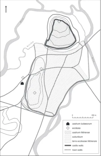
Fig. 7 Nitra, topography of the town in the High Middle Ages
7. kép Nyitra, a város topográfiája az Árpád-korban
The topography of high medieval Nitra 219
But taking into account the aforementioned finds and their character, it continued somewhat fur- ther toward the south. It can be assumed that even generally dated production features excavated in the space of a former stud farm (Hanuliak 1989, 200) are high medieval and together with others formed one spatial unit.
Also speaking in favour of the Mlyny location (and therefore likely Tržnica) being part of the Ni- tra extramural settlement is the amount of graph- ite pottery. During an analysis of high medieval graphite pottery from sites in slovakia, G. Fusek and J. Spišiak (Fusek–Spišiak 2005, 312–313) stated that in comparison with agrarian settle- ments, the composition of finds from early royal centres or the pre-urban phases of later towns has a significantly higher representation of precisely this type of pottery. while at the nearby rural set- tlement uncovered in Nitra-Šindolka the average values documenting the percentage of graphite wares present in features ranged only from 1.33%
to 3.60% (Fusek–Spišiak 2005, 313), the values from Nitra-Mlyny were from 9.66% to 26.75%
(König et al. 2014, 56–57).3
The Nitra suburbium after the middle of the 13th century
The Nitra extramural settlement underwent consid- erable changes roughly around the mid-13th century.
As it has been found, its southern part known from the Tržnica (Bednár – Fottová 2003, 310) and Mlyny (König et al. 2014, 90) sites does not show signs of continual settlement activities that were convincingly datable to later than the middle of the 13th century. By this time, this territory was essen- tially no longer used as before.
Yet another important change occurred in the following period: the construction of town walls protecting the extramural settlement (Fig. 8), a fact documented in both written sources and by archaeo- logical excavations.4 Perhaps the earliest reference is a document describing the extent of damage caused by an attack from the army of Matthew Csák (RDsl 1, 485–486, no. 1142), probably in 1313, dur- ing which the town walls and their towers (… tota etiam ipsa civitas Nitriensis meniis et turribus usque ad solum prostrata et diruta et horribiliter igne ex- titit concremata) were reportedly razed and burned (Brezováková 2002, 223). It can, therefore, be as- sumed almost with certainty that the fortifications were combined walls consisting mostly of a wood- en palisade or a wood and earth rampart. support- ing this conclusion was the find of the remnants of three stone side towers built at intervals along the west edge of the summit (Ruttkay 1999, 248). An iconographic depiction of Nitra from 1657 also doc- uments the wood and earth fortifications (Samuel–
Bednár 2012, 206, Fig. 10). The south line of the town walls is likely demarcated by the place where the lower town gate (the Turkish Gate) was later built. known from iconographic sources and old maps (e.g. Březinová–Samuel 2007, 48–49, Fig.
70), this gate was not demolished until 1859 (Zeme- neová 1998, 272).
The construction of the town walls also created new spatial arrangements. The territory protected by the walls began to be more intensely utilised and ac- quired a regular layout of individual urban elements such as market squares, building development and streets. In the case of the foundation of Old Town in Prague, a unique phenomenon occurred in the second half of the 13th century in connection with the construction of its fortifications: the extramu- Fig. 8 Nitra, topography of the town around 1300
8. kép Nyitra, a város topográfiája 1300 körül
220 Tomáš König ral settlement greatly exceeded the size of the en-
closed area. In the case of the Újezd sv. Martina settlement, the Old Town walls cut through the ho- mogenous settlement area and part of its built-up area was cleared and moved away from the fortified space (Cymbalak–Staňková 2014, 162). At the site of the later Republic Square (Náměstí Republiky), even impressive Romanesque buildings in the space beyond the walls were razed and the mentioned area remained for a long period of time essentially va- cant (Juřina 2009).
Although the extent of the Nitra extramural set- tlement clearly exceeds the space later surrounded by fortifications, there is still no evidence dem- onstrating that its shrinkage was related precisely to the construction of the walls. The handicraft activities that were demonstrably conducted in these areas were probably not moved behind the town fortifications, as the trend was exactly the opposite in emerging medieval towns (Podliska 2008). In Nitra, it is even possible to assume that a consid- erable amount of time passed between the end of settlement activities in the southern part of the ex- tramural settlement and the construction of the town walls, perhaps even decades. The surface of the road documented in the north-western part of the Mlyny site and datable to the second half of the 13th century was paved with stone pitching (König et al.
2014, 79, 90). One of the possible reasons for the construction of the road across the abandoned part of the extramural settlement could have been that it offered a shortcut for connecting the road running essentially along the Nitra River (Ruttkay 2006, 169–170) with the route running from Nyárhíd.
The strongest evidence for this hypothesis is the ori- entation of its excavated section and the assumption that it was not used for a long period of time.
If the abandonment of the large territory used previously for many years in the southern part of the Nitra extramural settlement was not connected with the construction of the town fortifications, then
it could have reflected a loss of economic potential for the town perhaps leading to a decline in its popu- lation. This suggestion would not be all that surpris- ing, as the importance of Nitra actually did decline in the 13th century. The existing evaluation of events known from historical sources connects its econom- ic decline with a change in the route of the ‘Czech Road’ and with the military conflicts occurring in the final third of the 13th century and at the begin- ning of the 14th century (Lukačka 1998, 161–165).
But while all of the mentioned events undoubted- ly had an impact on the further development of the town, a major decrease in the population of Nitra could have occurred somewhat earlier.
A historical event recorded in the first half of the 13th century could have had a decisive impact on the beginning of the process of Nitra’s gradual decline:
the invasion of Hungary by the armies of the Mon- golian ruler Batu khan in 1241, traditionally known as the Tatar invasion (Marsina 2008a, 9). As period documents state, the territory of southwest slovakia became an area in which the units of Orda khan operated. Nitra Castle was the target of one of their attacks. A letter from Hungarian church and secular officials addressed to the pope states that the town was still holding out against the Tatars at the begin- ning of February of the following year (Marsina 2008b, 52). Attention should also focus on the fact that mentions of the Tatars and their invasion also repeatedly appear in the charter of Nitra issued in 1248 (CDsl 2, 208–209, no. 298). In assessing the motivating factors that led the king to grant the priv- ileges, emphasis has only been placed so far on the recognition of the town population for its loyalty, assistance and valorous efforts in the fight against the Tatars (Lukačka 1998, 159; Marsina 2002, 191); however, there could have been other reasons behind this decision. The town privileges can be un- derstood mainly as a stimulus followed by a period of prosperity that perhaps ended precisely with the Tatar invasion.
Notes
1 The article was written with the support of the sci- entific Grant Agency VEGA 1/0827/16 entitled ‘Be- ginnings of the Formation of Urban Space in Brati- slava’.
2 The first reference to this settlement under the name Párovce (Parulcha) comes from 1343 (Zemene 1977, 130–131).
3 The first value corresponds to the average percent-
age of graphite pottery among all of the vessels at the given site. The second value is the representation of graphite pottery in features in which it occurred.
4 The parish Church of st. James, archaeologically un- known, was intentionally not drawn on the plan. with respect to the Middle Ages, this church is not known until the second quarter of the 14th century, when it first appears in a written source (MVSl 1, 56).
The topography of high medieval Nitra 221
WRITTEN SOURCES
CDsl 2 Marsina, R. (red.), Codex diplomaticus et epistolaris Slovaciae, tom. 2. Bra- tislava 1987.
Chronica Boemorum
Bretholz, B. (red.), Cosmae Pragensis Chronica Boemorum, Monumenta Germaniae historica, scriptores rerum Germanicarum nova series, tom. 2.
Berlin 1923.
MVsl 1 Sedlák, V. (red.), Monumenta Vaticana Slovaciae, tom. 1. Trnavae–Romae 2008.
RDsl 1 Sedlák, V. (red.), Regesta diplomatica nec non epistolaria Slovaciae, tom. 1.
Bratislava 1987.
BIBLIOGRAPHY Bednár, Peter
2002 Nitra § 3. Historisches. In: Reallexikon der Germanischen Alterumskunde, Bd. 21. Berlin–New York, 224–226.
Bednár, Peter–Fottová, Eva
2003 Nitra-tržnica – príspevok k poznaniu zázemia stredovekého mesta. – Nitra- Markthalle – Beitrag zur Erkenntnis des Hinterlandes der mittelalterlichen Stadt. Archaeologia Historica 28, 303–315.
Brezováková, Blanka
2002 Nitra a Matúš Čák. – Nitra und Matthäus Chak. In: Marsina, R. (ed.), Nitra v slovenských dejinách. Bratislava–Martin, 220–225.
Březinová, Gertrúda–Samuel, Marian
2007 Prehľad osídlenia. In: Březinová, G.–Samuel, M. (eds), Tak čo, našli ste niečo? Svedectvo archeológie o minulosti Mostnej ulice v Nitre. Nitra, 15–69.
Cymbalak, Tomasz–Staňková, Veronika
2014 Středověké osídlení v jižním předpolí staroměstských hradeb v Praze. Nový pohled na základě archeologických výzkumů na ploše novostavby Quadrio.
Forum urbes medii aevi VIII/2. Brno, 152–173.
Fusek, Gabriel
2008 Osídlenie Nitry v 10. storočí. Kontinuita alebo diskontinuita? – Settlement of Nitra in 10th century. Continuity or discontinuity? In: Štefanovičová, T.–
Hulínek, D. (eds), Bitka pri Bratislave v roku 907 a jej význam pre vývoj stredného Podunajska. Bratislava, 295–304.
Fusek, Gabriel–Spišiak, Ján
2005 Vrcholnostredoveká grafitová keramika z Nitry-Šindolky. Archeológia a mineralógia. – Hochmittelalterliche Graphitkeramik von Nitra-Šindolka.
Archäologie und Mineralogie. Slovenská Archeológia 53/2, 265–336.
Hanuliak, Milan
1989 Nitra, časť Staré Mesto. In: Bialeková, D. (ed.), Pramene k dejinám osídlenia Slovenska z konca 5. až z 13. storočia, zv. I/1, Bratislava, hlavné mesto SSR a Západoslovenský kraj. Nitra, 195–210.
Jamrichová, Andrea
1997 Mýtne stanice na Slovensku do roku 1323. Diplomová práca. Katedra histórie, Fakulta humanistiky TU v Trnave. Trnava.
Juřina, Petr
2009 Výstavba hradeb a vznik náměstí. In: Juřina, P. (ed.), Náměstí Republiky – výzkum století. Praha, 67–71.
König, Tomáš
2016 Nitrianski Slovania a zánik Veľkej Moravy. – The Slavs of the territory of
222 Tomáš König
Nitra and the downfall of Great Moravia. In: Chudzińska, B.–Wojenka, M.–
Wołoszyn, M. (eds), Od Bachórza do Światowida ze Zbrucza. Tworzenie się słowiańskiej Europy w ujęciu źródłoznawczym. Księga jubileuszowa Profe- sora Michała Parczewskiego. Kraków–Rzeszów, 181–191.
König, Tomáš–Bodoriková, silvia–Budaj, Marek
2014 Nitra-Mlyny – stredoveké osídlenie lokality. Bratislava.
Lukačka, Ján
1998 Nitra vo vrcholnom stredoveku (1248–1386). In: Fusek, G.–Zemene, M. R.
(eds), Dejiny Nitry. Od najstarších čias po súčasnosť. Nitra, 159–175.
2002 Cestná sieť v Nitre a v jej najbližšom okolí v 13. a 14. storočí. – Wegenetz in Nitra und Nahumgebung. In: Marsina, R. (ed.), Nitra v slovenských dejinách, Bratislava–Martin, 208–211.
2010 Nitra. In: Lukačka, J.–Štefánik, M. (eds), Lexikon stredovekých miest na slovensku. Bratislava, 283–291.
Marsina, Richard
1977 Nitra vo včasnom a vrcholnom stredoveku. In: Fojtík, J. (ed.), Nitra. Bratisla- va, 27–40.
2002 Základné mestské privilégium pre Nitru z roku 1248. – Das Grundprivileg für Nitra (Neutra) aus dem Jahre 1248. In: Marsina, R. (ed.), Nitra v slovenských dejinách. Bratislava–Martin, 190–196.
2008a Úvod. In: Marsina, R.–Marek, M. (eds), Tatársky vpád, Budmerice, 9–18.
2008b Prosba k pápežovi o pomoc – Stoličný Belehrad 2. februára 1242. – Suplicato ad papam – Albe 1242 febr. 2. In: Marsina, R.–Marek, M. (eds), Tatársky vpád. Budmerice, 50–55.
Mencl, Václav
1938 Středověká města na Slovensku. Bratislava.
Podliska, Jaroslav
2008 Herstellung und Bearbeitung von Eisen in der vorlokationszeitlichen Sied- lungsagglomeration von Prag. Ein archäologischer Beitrag zur Erkenntnis der nichtagrarischen Produktion des 9.–13. Jahrhunderts. In: Poláček, L.
(ed.), Das wirtschaftliche Hinterland der frühmittelalterlichen Zentren. Inter- nationale Tagungen in Mikulčice VI. Brno, 165–178.
Procházka, Rudolf
2000 Zrod středověkého města na příkladu Brna (k otázce odrazu společenské změny v archeologických pramenech). – Entstehung der mittelalterlichen Stadt – Beispiel Brünn (Zur Frage der Widerspiegelung der Gesellschafts- veränderung in archäologischen Quellen). In: Mediaevalia Archaeologica 2.
Praha–Brno, 7–158.
Ruttkay, Alexander
1995 Genese und Typologie der mittelalterlichen Städte im Gebiet der Slowakei vor dem 14. Jahrhundert. In: Brachmann, H. (ed.), Burg – Burgstadt – stadt.
Zur Genese mittelalterlicher nichtagrarischer Zentren in Ostmitteleuropa.
Berlin, 296–306.
1996 Zur Topographie von Nitra (Neutra) im 12.–14. Jahrhundert. Acta Archaeo- logica Academiae scientiarum Hungaricae 48, 489–491.
1999 Zur Beziehungen zwischen Burgen und Städten in der Slowakei (topographi- sches Beispiel von Nitra). In: Durdík, T. (ed.), Burg und stadt. Castrum Bene 6.
Praha, 233–252.
Ruttkay, Matej
2006 Záchranný archeologický výskum v Nitre na Mlynskej ulici. – Archäologis- che Rettungsgrabung in der Mlynská Str. in Nitra. Archeologické výskumy a nálezy na slovensku v roku 2004, 169–170, 302–303.
Ruttkayová, Jaroslava–Ruttkay, Matej
1997 Výsledky výskumu v Nitre-Starom meste v roku 1994. – Archäologische
The topography of high medieval Nitra 223
Forschungsergebnisse in der Stadt Nitra-Altstadt im Jahr 1994. Archaeolo- gia Historica 22, 103–113.
Samuel, Marian–Bednár, Peter
2012 Výskumy brán Nitrianskeho hradu v areáli bývalého Župného domu. – Re- search of Nitra Castle’s gates in the area of former County House. Monumen- torum tutela – Ochrana pamiatok 24, 197–212.
Šmilauer, Vladimír
1932 Vodopis starého Slovenska. Praha–Bratislava.
Zemene, Marián
1977 Krátke dejiny obcí pripojených k Nitre. In: Fojtík, J. (ed.), Nitra. Bratislava, 121–133.
Zemeneová, Viera
1998 Stavebný vývoj mesta. In: Fusek, G.–Zemene, M. R. (eds), Dejiny Nitry. Od najstarších čias po súčasnosť. Nitra, 272–279.
AZ ÁRPÁD-kORI NYITRA TOPOGRÁFIÁJA
ADALékOk A köZéPkORI VÁROsOk TOPOGRÁFIÁJÁHOZ sZLOVÁkIA TERüLETéN Összefoglalás
Az Árpád-kor folyamán – a 11. századtól a 13. szá- zad közepéig – Nyitra az egyik legfontosabb is- pánsági központok egyike volt Magyarországon.
A temetők feltárása megmutatta, hogy folyama- tosan lakott volt a Morva Fejedelemség korától, s valószínűleg ekkortól kezdődően megőrizte a köz- ponti szerepét is. Éppen ebből a kontinuitásból adó- dóan szabálytalan alaprajzzal rendelkezett, melynek utcaszerkezetét a terepi adottságok és a távolsági út- hálózat határoztak meg (1. kép).
Az Árpád-kori város topográfiájának modern kutatásai elsősorban a történészek oldaláról in- dultak meg (V. Šmilauer, V. Mencl, R. Marsina).
Meglehetősen behatárolt mennyiségű írott forrás- ból indultak ki, melyekben csak töredékes utalások találhatók a város méretéről és belső felosztásáról.
Véleményeik a lokalizációról és a váralja település méretéről eltértek. A kutatás második szakasza már elsősorban a régészeti feltárásokat vezető szakem- berekhez fűződik. (A. Ruttkay, J. Ruttkayová és M.
Ruttkay, illetve P. Bednár). Ugyan a kísérleteiket mindig grafikus formában is ábrázolták (2., 5. kép), munkáikban hangsúlyos szerepet kapott a kulcsfon- tosságú írott forrás, a nyitrai káptalan 1247. évi ok- levelének interpretációja. Az említett forrás castrum Iudaeorum helyszínét a Halom (Vŕšok) magaslattal kapcsolták össze. Véleményük szerint a város olyan különálló részéről volt szó, mely saját erődítéssel is
rendelkezett. Nyitra városát még két, nem erődített városrész alkotott (suburbium és civitas). A forrás új értelmezése szerint castrum Iudaeorum Párutcá- val egy önálló településsel, míg a suburbium a nyit- rai Várhegyet (Hradný vrch) körbefolyó Nitricska patakától délre elhelyezkedő, nyitrai váraljával kap- csolható össze (6. kép).
A közelmúltban a Vásártér (Tržnica) és Malmok (Mlyny) lelőhelyeken végzett feltárások olyan Ár- pád-kori leleteket szolgáltattak, melyeket szükséges volt összekapcsolni a város településtörténetéről való addigi ismereteinkkel. A leletek azonos korúak voltak és mind gazdasági vagy ipari jellegű jelen- ségekhez lehetett kötni. Ezek alapján egyértelmű- en arra következtethetünk, hogy a város kiterjedése eredetileg nagyobb lehetett, mint a később városi erődítések által körülvett terület (7. kép). Városi te- lepülés mellett nem csak a lelőhely területi kapcso- latai szólnak, hanem a grafitos kerámia nagy aránya.
Nagyjából a 13. század közepe után a nyitrai váralja déli része jelentősen összement. A korábbi korszakkal összevetve, a Vásártér és Malmok lelő- helyeken a települési aktivitás már nem folytatódik.
Ez a törés még valamikor a városi erődítések 1313 előtti kiépítését megelőzően történt meg (8. kép).
A lakott terület feltehetően az 1241. évi tatárjárás Nyitrát is érintő pusztító hatásainak következtében zsugorodott össze.
224 Tomáš König
V období vrcholného stredoveku (11. až polovica 13. storočia) bola Nitra jedným z najvýznamnejších hradských miest v Uhorsku. Výskum pohrebísk ukázal, že bola kontinuálne osídlená od veľkomo- ravského obdobia, odkedy si zrejme zachovala aj funkciu správneho centra. Ako stredoveké mesto vychádzajúce z kontinuity osídlenia malo pritom nepravidelný pôdorys, podmienený geomorfologic- kým členením terénu a priebehom ciest, ktoré dali základ jeho uličnej siete (obr. 1).
Počiatky moderného bádania topografie vrchol- nostredovekého mesta sú spojené bádateľmi z ob- lasti historických vedných disciplín (V. Šmilauer, V.
Mencl, R. Marsina). Vychádzali z veľmi obmedze- ného množstva písomných prameňov, v ktorých sa nachádzali strohé zmienky o rozsahu a vnútornom členení priestoru mesta. Ich názory na lokalizáciu a rozsah jeho podhradia sa rôznili. Druhá etapa bá- dania sa viazala predovšetkým už na odborníkov z radov archeológov (A. Ruttkay, J. Ruttkayová, M. Ruttkay a P. Bednár). Hoci výsledky ich snažení dostali vždy aj podobu grafického spracovania (obr.
2–5), boli postavené ťažiskovo naďalej na interpre- tácii kľúčového písomného prameňa, listiny nit- rianskej kapituly z roku 1247. Lokalitu uvádzanú v zmienenom dokumente ako castrum Iudaeorum dá- vali do súvisu s vyvýšenou polohou Vŕšok. Podľa ich názoru išlo o osobitnú časť mesta s vlastným opev- nením. Mesto Nitra mali spoluvytvárať ešte dve ne-
opevnené časti (suburbium a civitas). Nová interpre- tácia tohto písomného prameňa, odvodená dôsledne z priestorových vzťahov, spája castrum Iudaeorum s Párovcami, samostatnou osadou a suburbium s nit- rianskym podhradím, rozkladajúcim sa južne od Nit- ričky, potôčika obtekajúceho Hradný vrch (obr. 6).
Archeologické výskumy uskutočnené v nedáv- nej dobe v polohách Tržnica a Mlyny priniesli vr- cholnostredoveké nálezy, ktoré bolo potrebné dať do súvisu s ostatnými poznatkami o osídlení mesta.
Spoločnou črtou týchto nálezov bol ich hospodársky či výrobný charakter a taktiež datovanie. Dovoľujú nám uvažovať o tom, že rozsah mestského osídlenia bol pôvodne väčší ako priestor neskôr ohraničený mestským opevnením (obr. 7). V prospech toho, že išlo o mestské osídlenie hovoria nielen priestorové súvislosti, ale azda aj percentuálne zastúpenie gra- fitovej keramiky.
Zhruba po polovici 13. storočia došlo pravdepo- dobne k výraznej redukcii osídlenia južných častí nitrianskeho podhradia. V porovnaní s predchádza- júcim obdobím, polohy Tržnica a Mlyny sú totiž od tohto času bez stôp kontinuálne prebiehajúcich síd- liskových aktivít. Stalo sa tak akiste ešte pred vybu- dovaním mestského opevnenia, s ktorým rátame v období pred rokom 1313 (obr. 8). Príčinou tejto re- dukcie osídlenia mohol byť úpadok mesta vyvolaný ničivými dôsledkami tatárskeho vpádu do Uhorska v roku 1241.
TOPOGRAFIA VRCHOLNOsTREDOVEkEJ NITRY
PRísPEVOk k TOPOGRAFII sTREDOVEkýCH MIEsT NA sLOVENskU Abstract
Mgr. T. König, PhD.
Comenius University in Bratislava Faculty of Arts
Department of Archaeology Gondova 2
814 99 Bratislava slovakia
e-mail: tomas.konig@uniba.sk