188 WATER@RISK | www.geo.u-szeged.hu/wateratrisk
1. Introduction
Viktória Blanka; Zsuzsanna Ladányi; Gábor Mezősi; János Rakonczai
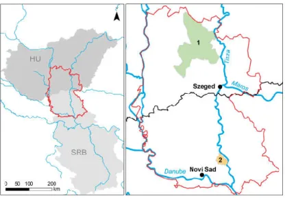
One of the most important environmental problems nowadays is climate change, the negative e ects of which have an impact on the whole planet. In the last 100 years the average temperature of the Earth increased by +0.7°C and undesirable changes occurred also in case of precipitation, as long periods without rainfall and extreme pre- cipitation events became more frequent in large parts of the temperate zones on both hemispheres (OMSZ 2019). The climate change has a considerable impact on the low- land areas of southeast Hungary (Csongrád and Bács-Kiskun counties) and Vojvodina, including the study area (Fig 1.). Due to the climate change and the natural geographic conditions, the water supply of the region is showing extreme variation, the area suf- fers from both drought (Fiala et al. 2014) and inland excess water (Bozán et al. 2013) – these can take turns, and occur in consecutive years or even in the same year. This is the reason why the research and geographical observation of the problems related to climate change and hydrological extremes is very important in the region, which started decades ago (Kovács 2007, Ladányi et al. 2011a, Rakonczai 2011).
Figure 1.1 Location of the study area
The majority of this area is lowland, where the mean annual temperature is around 11°C and the annual precipitation is 500-600 mm. The highest mean temperature occurs in July, typically between 21°C and 23°C, while the rainfall is around 300 mm in the summer half of the year (Smailagic et al. 2013, OMSZ 2019). Examining the cli- mate change trends of the last decades reveals that the temperature has been rising and the precipitation level has been slightly decreasing (Blanka et al. 2013; Spinoni
189 WATER@RISK | www.geo.u-szeged.hu/wateratrisk et al. 2013), resulting in a 20-30 mm yearly precipitation shortage in the area. It was also observed that the frequency of extreme weather conditions’ occurrence has also changed. Years drier than the average have become more frequent, and the distribu- tion of the rainfall is turning less and less favourable, as beside the long dry periods, extreme precipitation events occur especially in the summer causing an increase in the runo proportion of the valuable water resources (Mezősi et al. 2016).
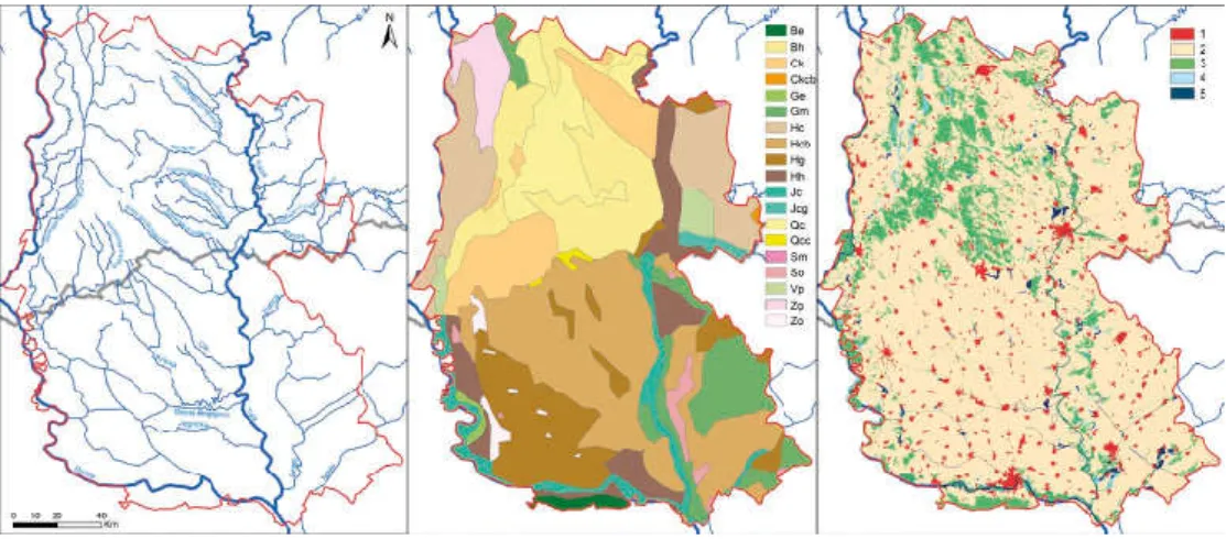
In the examined area the most important rivers are the Danube, the Tisza/Tisa River, the Maros River, and the Tamis River; besides these, most of the surface water ows are arti cial canals (Fig 2). Parallel to the changes in the climate, the spa- tial and temporal variability of the surface water volumes were also observed (Kiss and Blanka 2012, Sipos 2006). This not only generates a growing ood (e.g. on the Danube in 2013) and inland excess water hazard, but also longer periods of water shortage that contribute to a growing economic, social and environmental problem for the study area. In general it can be stated that the annual water balance of the region shows a negative trend, as regards both surface and ground waters. In a large part of the year the surface runo is insigni cant, which greatly contributes to the climate sensitivity of the area, and to the growing water stress that is likely to occur in the future.
Figure 1.2 Water ows, soil types (FAO 19895) (Be: Eutric Cambisol, Bh: Humic Cambisol, Ck: Calcic Chernozem; Ckcb: Vermi-Calcaro-Calcic Chern.; Ge: Eutric Gleysol, Gm: Mollic Gleysol ; Hc: Calcaric Phaeozem; Hcb: Vermi-Calcaric Phaeozem, Hg: Gleyic Phaeozem; Hh: Haplic Phaeozem;; Jc: Calcaric Fluvisol; Jcg: Gleyo-Calcaric Fluvisol; Qc: Cambic Arenosol; Qcc: Calcaro-Cambic Arenosol; Sm: Mollic Solonetz; So: Orthic Solonetz; Vp: Pellic Vertisol; Zg Gleyic Solonchak; Zo Orthic Solonchak) and land use (Corine 2018) (1: Arti cial surfaces; 2: Agricultural areas; 3: Forests and semi natural areas;
4: Water bodies; 5: Wetlands) of the study area
The study area is diverse in terms of soil type, physical properties and soil moisture regime of the soils (Fig 2b). Chernozem soil and its di erent variations dominate the area; their crumbly structure, resulting from the advantageous soil formation processes ensures good water and nutrient management conditions for agricultural production. Sandy soils (blown sand, humic sandy soils and chernozem-type sandy
190 WATER@RISK | www.geo.u-szeged.hu/wateratrisk
soils) can also be found in considerable proportions; these soils having unfavoura- ble moisture regime due to huge water in ltration and weak water-holding capacity.
Meadow soils are also common in the region, which have medium or weak in ltra- tion and good water-holding capacity.
The land cover and land use of the area is dominated by agricultural lands (Fig 2c).
In the last 200 years large areas of land became used for farming purposes, there- fore the proportion of agricultural land is high, and the natural vegetation remained only in relatively small areas. Even in these areas, where the natural vegetation sur- vived, unfavourable processes can be observed, because the climate change of the last few decades and human activities resulted in natural wetland habitats starting to dry out, and this process is accompanied by the degradation and transformation of the vegetation (Rakonczai et al. 2014).
Extreme water balance situations cause serious socio-economic and environ- mental damages, and they also generate major water management con icts. In the periods of inland access water inundations, the drainage practices of excess water generate con icts, in both populated areas and outside of towns and villages, while in the drought periods the limited availability of water and water use practices cause problems. Several problems are related to the irrigation of agricultural land, because in spite of the relatively dense canal network – in the present conditions – these canals are hardly suitable for irrigation purposes. Due to the lack of surface waters that can be used for irrigation, at the time of dry periods/droughts farmers use water from underground resources, which just makes the problem of decreas- ing groundwater resources worse, which are already decreasing because of the climate change. Another problem is that water retention and the utilisation of waste water produced in the area is still at an initial phase, therefore the water resources that are generated aren’t utilised adequately (Rakonczai et al. 2014).
Mitigating the negative e ects of drought and inland excess water, and manag- ing land use and water resource related problems are among the most important complex environmental problems to be solved in the region. E ective management requires collecting accurate and timely information that describes the current water balance situations and a better understanding and quanti cation of negative e ects and risks, which can provide fundamental information for planning e cient inter- ventions. It is essential to implement the planning of water management in a (small) catchment level, and it is also important to ensure the e cient cooperation of the stakeholders in both planning and implementation.
The project that provides the background for this book and the presented devel- opments seek to contribute to managing the problems introduced, and to planning water resource management more e ciently: by developing regional monitoring methods and collecting information to observe the formation of drought and inland excess water (chapters 2, 3 and 4), by evaluating the risks and the damages caused (chapters 5 and 6), and by reconsidering the operational management of the canal network, based on much more detailed and accurate data than before. For devel- oping improvement ideas for the operational management of the canals, detailed examinations were performed in two pilot areas, the catchments of Curug-Zabalj (Serbia, chapter 7) and Dong-ér (Hungary, chapter 8) (Fig 1).