The University of West Hungary
PH.D. TH E S I S
Multiple approach researches on forest types in the southern part of Tés Plateau
BÖ L Ö N I, János
Sopron 2004
The University of West Hungary, Sopron, Roth Gyula Science of Forestry and Wild Management PhD School
Biologocal Principle of Forestry Program
Supervisor: Dr. Koloszár, József
Departnent of Silviculture, The University of West Hungary
I. Background and goals of the research
The landscape and the vegetation of the southern part of the Tés Plateau (Bakony Mountains, Trans-Danubian Middle Range, Hungary) are very diverse. The untouched nature and the centuries-long human impact can be seen at the same time here. The flora of the studied area was well investigated formerly, but there was not much known about the vegetation. Consequently, the main purpose of this work was to compile a vegetation- monograph of this area. Elaborated similar studies from different regions have been published in the recent years by KIRÁLY2001, CSIKY 2002 and TÍMÁR 2002.
Many unsolved questions has been arisen about the identification and distinction of the vegetation units (existence of which is often under debate) and the transitions and connections between them; and about the types developed under degradation and land use history. This led to tighten the original focus of the paper only to the forest vegetation, and in the same time also broaden it far beyond distinguishing and classifying the elements of forest vegetation with providing fundamentals and carrying out analysis of land use history and dynamics of Central-European deciduous forest types found in the area. Different approaches to vegetation classification are stressed in the thesis under three main focuses, namely climate, forest-history and vegetation.
The thesis seeks answer for the following questions:
x What is the predicable vegetation of the area according to the site conditions and is it in harmony with the present situation?
x What are the main impacts on the area? How did they influence the floristic composition, structure and to what extent can the historical studies reveal these influences?
x How could the former vegetation look like? To what extent did it change by now? Are there any general or local conclusions to be drawn?
x How can the vegetation of the area be classified? Are there any characteristically separate types or it rather looks like a series of transitions?
x How do the range, the pattern and the proportion of the different vegetation types look like?
x Are there any connections among the groups created by different approaches, or among the groups and their environment, the site conditions?
x Is there any approach which can be related to forest-dynamics?
The thesis attempts to surpass the classification of vegetation and to complete it with other approaches without regarding any of them superior.
II. The studied area and the applied methods
The studied area is situated in Hungary, in the Trans-Danubian Middle Range, in Keleti- (Southern-) Bakony, in the southern part of the Tés-plateau and the foothill areas connected to it. Though low mountains predominantly of calcareous rocks dominate the landscape, it has very diverse geomorphology. The heavily dissected steep hillsides are connected with extended flat plateaus, deep valleys and small depressions. The hillsides are divided by smaller or bigger rocks, which form craggy tops or deep caldrons. On the foothill areas there are also smaller hills characteristic to the dolomite ranges.
The geological conditions are not so diverse indeed. Dolomite is the main bedrock type in the studied area, while in a smaller patch dachstein limestone is also present and in the foothill areas or in the bottom of the valleys different young detrital deposits are found.
Dolomite bedrock determines principally the soil types of the studied area. Main part of the area is characterised by the mixture of shallow, rocky rendzinas and deeper brown forest soils. On the hillsides and in the valleys, slope deposits with loess illuvation moderate the extreme water regime of shallow soils.
From the environmental conditions climate is discussed in the thesis in more details.
The work is based on the data of seven meteorological stations (Veszprém, Öskü, Hajmáskér, Várpalota, Tés, Királyszállás, Isztimér) around the studied area. The climate is analysed in this paper by the averages of precipitation and temperature, by the year-to-year and within-year distribution of precipitation averages, by the frequency of each precipitation distribution type (ZÓLYOMI 1942, 1958, ZÓLYOMIet al. 1992, 1997, KUNet al. 2004) and by the Gaussen-Walter climatic diagrams.
Literature, old data of the regional archives and especially old forest management plans from the 19th and the early 20th centuries served as basis for the studies on forest history.
The field sampling was carried out with phytosociological relevees and stand- descriptions. The replicability and the non-subjective arranging of the samples were important during the planning of fieldwork.
The main part of the sampled points were arranged by well defined transects. The starting points of these transects were easily identifiable by compass. Due to this, the multitude of the sampling points form a more or less regular grid. This method created a raster map, where the distance between the relevees, taken in the nodes of the grid, is 20 – 50 steps under heterogeneous geomorphology and 50-150 steps under homogenous geomorphology.
This sampling type is similar to a non-systematic random one (PODANI 1997), and it is clearly different from the sampling of subjectively chosen areas. More than 1700 full relevees and descriptions of the stands were taken, which are supplemented with 300 thoroughly detailed and 800 simpler samples.
In deciduous forest on temperate climate the advised size of the phytosociological relevee (the estimated minimi areal) is 100 – 500 m2 (WESTHOFF– VAN DERMAAREl 1980).
According to this the samples were taken as circles with the radius of 12-16 metres, so the areas of them were 500 – 800 m2. Sampling of the canopy layer composition was carried out in bigger areas (1000 – 2000 m2), while size of trees require data collection more extended in space.
All stands were qualified by stand structure and dynamics. Categories elaborated for structural qualification of Hungarian Strict Forest Reserves (CZÁJLIK 1998, 2002) with some modification was used as basis for this study.
All of the sampled sites were visited at least two times, once in spring and once during the summer. At the second time, in case of needed, supplementation and modification of descriptions, relevee data and stand structure has been made. (If a species was present at the time of both sampling event, the higher abundance was recorded.)
One of the main questions of vegetation science of descriptive type is vegetation classification. Reviewing the literature of vegetation classification and the field experiences gave ground to the multiply approach used in the thesis. This approach is the most similar to forest site typology, although it was applied with a wider view.
During the data analysis for overlooking the multitude of data ordination has been used, which usually created homogenous clouds of points. For further exploration of the data, some group-creating methods were used, by the result of which main types were defined and compared. The types used for description and demonstration were defined this way.
The thesis uses different approaches in the analysis of the herb layer. First the species were grouped into eco-groups (CSAPODY et al. 1962) and coenotaxonical groups (SOÓ 1968, 1980, SIMON1992, MOLNÁR– RÉDEI 1995, BORHIDI 1993, 1995). Then some simplification were used for the clearer arrangement and interpretation of the data.
For the comparison of the water regime the twelve-graded Borhidi relative ecological indicator values of optimum humidity and soil moisture (BORHIDI 1993, 1995) were used.
According to the field experiences the dominant life forms of herb layer (e.g. grasses- sedges, geophytes, etc.) seemed to be well recognisable. The species were grouped to very simple functional groups according to their life-traits for this analysis (comp. BARTHA et al.
1998).
The comparison of the results of the different approaches is presented and discussed by as a pair to pair table on the basis of frequency distribution of particular categories.
III. Summary of the results
The climatic analysis showed a slight western-eastern and a strong northern-southern climatic gradient in the Keleti-(South-)Bakony. On the Tés Plateau the data predict mesic deciduous forests, which means that the map of climazonal vegetation of Hungary (BORHIDI
1961, 1981, most detailed in 1989) will need some revision. The cited map showed closed oak woods on the middle and eastern part of the area, while based on the current research, the area of oak-hornbeam forests and sub-montane beech forest expand a bit more to east.
However not further than 10-15 kilometres the climate only supports forest-grassland mosaics (forest steppe).
The area studied in details is situated in the middle of the climatic gradient. The quantity and distribution of annual precipitation can considerably vary; the probability of sub-Mediterranean and continental-central European precipitation distribution types is similar. Adding to this, quantity of precipitation can change in a longer period of time. This altogether means that climate of the fringe of the plateau can considerably fluctuate. The rocky soils on hard calcareous bedrock amplify this effect even more. Consequently, very diverse vegetation thrives in this area, where the bio-geographical conditions favour the closed, humid forests and the forest-grassland mosaics at the same time. These diverse environmental conditions within a very limited area indicate repeated presence of transitional types of the vegetation.
According to the geomorphology and the climate of the area, mesic forests can be predicted to the southern part of the Tés-plateau; dry, sunny oak woods, forest-grassland mosaics (Turkey oak – sessile oak forests, downy oak forests, oak low woods) to southern sides and foothill areas. On the southern fringe of the plateau within a very limited area, the mixture and transition of these forest types and different forest of rocky soils are to be found.
This altogether means that the climate of the fringe of the plateau can considerably fluctuate. The rocky soils on hard calcareous bedrock amplify this effect even more.
Consequently, very diverse vegetation thrives in this area, where the bio-geographical conditions favour the closed, humid forests and the forest-grassland mosaics at the same time. These diverse environmental conditions within a very limited area indicate repeated presence of transitional types of the vegetation.
On the basis of the historical data it could be revealed that human impact was usual in the area with irregular frequencies and strength. The most important of these is the conversion of forest area to arable lands, grazing of maintained forests and pastures and the use of forest wood. Consequently, there was a 20 km2 big, continuous clearing in the middle of the plateau the border of which coincides with the border of the loose sediments on the plateau. Forests and forest-grassland mosaics maintained only on rocky bedrocks and on shallow soils.
In the 19th century 2000-2500 sheep - among others - grazed the forest situated south from Tés village. Grazing was common in the whole area causing considerable changes in the composition and structure of the vegetation. On the end of the 19th century the use of forest wood was significant either. From the southern part of the plateau annually 2000- 2500 m3 wood was cut according to the Bishopric’s registries. In addition there were several other uses of the forests (charcoal- and lime-burning, forest use of local inhabitants, etc.), the impact of which is complementing to the cuttings.
The first forest management plans from the end of the 19th century inform us about how those forests under intensive land use could look like. The southern part of the plateau
was covered that time with understoked, but diversely structured forests. There were hardly any old-growth (older than 100 years) forests, although there were old individuals or groups of old trees and many juvenile growths and clearing on the place of present forests too. The average wood stock of the stands was far under today’s expectations.
Important changes happened in the history on the turn of the 19th and 20th century.
Grazing was gradually limited in one hand, and in the same time changes in the ownerships and the implication of governmental forest management plans caused the abandonment of some parts, mainly the slopes of southern exposition and then later nearly all rocky, steep hillsides. These parts could evolve in the last 50-120 years relatively untouched. Some conclusions in the field of forest dynamics can be drawn from these informations. (These conclusions are based on observations but no direct research was taken to this direction.)
The past 100-120 years period was not long enough for these stands to develop natural-like structures or physiognomy. The stands with best structure are to be found on the following places:
1. Nearly impossible to reach the stands (e. g. rock walls). It can be assumed that those stands could not have been totally cut before either.
2. There are hardly reachable, steep places, which could have been cut before, but not homogenously and old growth individuals and patches could survive.
3. The stands are on sites with good conditions, but there are other factors limiting the use (e. g. the area is part of the military shooting range).
It is noticeable that the poorer the site conditions are (shallower soil, steeper slope, southern exposition), the slower is the dynamics of the stand. On the steepest parts with shallowest soil the stands look nowadays still like being regularly thinned out. At the same time, counting of the annual rings shows that in these areas the age of downy oak trees with the diameter of 20-30 cm is 100 to 267 years (DÁVID 2004). On the southern side of Mórocz top in the parts not managed for a longer period of time, stands with open patches and well- developed high shrub layer are characteristic, which indicates that the dynamics of these stands is different from the mesic forests. On the basis of the results of data analysis, it can be presumed that in these stands with shallow soils right after the gap formation the well- developed shrub layer is strengthening and expanding further, while the establishment of young trees is delayed for years or even decades. Artillery fires, which has been stopped only 20-30 years ago also contributed to this process. The older gaps (or burnt areas) are characterised by high shrub layer, while young ones have short shrub layer.
The physiognomy of the sites in transitional position – nearly totally cut, than abandoned stands on not extremely shallow soils - is also transitional: it resembles the traits of former management, shows the characteristics of abandonment and presents that commence of the natural processes is rather slow. The canopy layer is characterised by many mature trees of the same age and some new saplings, but the intermediate ages are rare or absent. In other places gap formation had already taken place, but the saplings are missing or only shrub species are present in the gaps.
The most impressive changes are noticeable in the Bér Hill and partly on the northern part of Musti-haraszt Hill. These areas were nearly totally cut at the end of the 19th century, but there were old growth trees and patches maintained. Among the abandoned part – partly because of grazing, partly because of shallow soils – patches of clearings and grasslands remained. After the abandonment on the clearings and on the grassland patches the forest started to recover, the patches with remnant trees became closed forest. The two different types can be recognised in several places nowadays either forming a diverse mosaic. On the
patches formerly forested there are stands with variable structure, while on the clearings and on grasslands homogenous young growth or middle age forests have developed. In the abandoned forests the herb layer still supports some species of dry grasslands (e. g. Orchis tridentata, Adonis vernalis, Vinca herbacea).
The regularly managed stands (on the Ballai-magyal and northern from the range of Ballai-magyal and Bér Hill) the stand structure and composition still reveals the former and present human impact. In the southern part of Ballai-magyal, in the oak forests the traits of regular coppicing and clearing are visible. Consequently these stands contain less associate tree species, the stand structure is more homogenous, the shrub layer is often missing.
Considerably changed species composition of beech forests shows the human impact in the northern part. Significant changes happened in northern fringe of the plateau, which was studied in details, in the range of Hegyes-berek – Köves Hill – Téses Top: common ash and hornbeam replaced the beech in extended areas, in some places there are Turkey oak and pine forests. The changing conditions did not favour beech either, this tree species common in the 19th century became rare till now. The study also pointed out that the direction and extent of the changes is influenced by site conditions beyond human impacts:
there is a relation amongst forcing back of beech, time of regeneration and site conditions.
In the northern part of the studied area (Hegyes berek), where soils are deeper and most of the slopes are slightly tilted to north, there are nearly unmixed homogenous beech forests, which differ from the ancient forests in canopy density and simpler age-structure.
There is another situation on the top of Köves Hill, since on the southern – southern-eastern part there were unmixed beech forests prior to regeneration, and now there are common ash and hornbeam dominated forests have developed.
On the Köves Hill in 2000 the proportion of beech was only 20 percent, the common ash was 46 and the hornbeam was 33 percent, in the area of Csákány Valley and Két Futóné-köze in 1955 the proportion of beech was only 17 percent, of common ash was 55 percent (today the ratio is 32 and 50 percent). The rapid shift from beech to common ash can be interpreted with successive reproductive cuttings or nearly clear cuttings; and with shallow, rocky soils. For illustrating the “results” of regenerative cuttings we remark that the crown closure in 1955 is nearly the same as at the end of 19th century. This is clearly visible on the aerial photo, where the canopy closure of juvenile growths is low especially on the tops.
The studies based on physiognomy resulted in badly arranged, complicated categories and distribution patterns, which still showed some important relations. The stands have not been managed for a longer period of time, have a diverse structure only in some parts of the area, and in many cases the structure is more homogenous. Low canopy closure of the stands in the southern slopes is seems to be natural and caused by site conditions.
The stands with undeveloped shrub layer are frequent in northern exposition, where there are usually beech dominated mesic forests. The stands with well-developed secondary tree layer and shrub layer are situated in the sides of southern exposition. The upper canopy layer of these stands is not totally closed; the sunlight can reach the downer layers, which supports the development of secondary canopy layer and dense shrub layer. In the valleys with deeper soils, tree species are dominant in the secondary layers, while on the hilltops with shallower soils there are rather shrub species present.
The classification of the composition of canopy layer resulted in clear, well-divided types and transitions among them (Table 1.). The types are characterised with particular tree species with narrow ecological tolerance and definite site condition demands. The series are consisted of combinations of different proportions of several tree species with different site
condition demands, where the tree species of mesic forests are mixed with species of dry forests. Major part of the relevees (75 percent, 1442) can be grouped more or less unambiguously to the types or to the series, but there is still many left (25 percent, 475), which are on the transition between groups and series (they can not be grouped into any definitely).
Table 1. Types and series of the tree species composition Types:
I. Beech forests (147 relevees, 7,7 percent). Nearly unmixed forest dominated by Fagus sylvatica, where the proportion of beech is not less than 70 percent. The most homogeneous type, the grouping methods handled this type uniformly. On the area studied in detail this type is restricted to the steep slopes of northern exposition and to bottom of deep valleys.
One range northern from the southern fringe of the plateau, this type thrives on slight slopes of northern exposition either.
II. Sessile oak – Turkey oak dominated stands (171 relevees, 8,9 percent). Handled more or less uniformly by grouping methods, this type is characteristic on extended areas in Hungary. The proportion of the two oak species together reaches 80 percent. The type can be related to site conditions definitely. This type is usually present in southern exposition on not too steep slopes with deeper soils, where besides dolomite another rock type participates in the soil formation. If the slope becomes steeper or the soil is more rendzina-like, then the following type takes its place.
III. Downy oak dominated stands (411 relevees, 21,4 percent). These stands are usually mixed and dominated by three xerotherm tree species (Quercus pubescens, Qu. cerris, Fraxinus ornus) with sub-Mediterranean range. The proportions of the three tree species can be variable but the proportion of downy oak reaches 5 percent and the proportion of Turkey oak does not exceed 85 percent. The proportion of other mesic tree species is less then 5 percent. This type is the most frequent in the studied area; the stands are present on steep slopes of southern exposition with shallow soils, mainly on the downer parts of the slopes.
The steeper is the slope the higher altitude this type can reach. On the extremely steep slope of Mórocz Top it reaches exceptionally 500 metres above see level, while on the milder Bér Hill it reaches only 450 meters.
Series:
IV. Beech – common ash – lime – hornbeam series (261 relevees, 13,6 percent). It is consisted of mesic tree species. The most important is Fagus sylvatica, Carpinus betulus, Fraxinus excelsior,Acer and Tiliaspecies. These stands are usually mixed but except beech all of the other tree species can be dominant. The proportion of oak species does not exceed 15 percent. They are mainly mesic, shady forests but they also can be forests with more light (mainly Fraxinus ornus dominated stands). This series can be divided to two sub- series. One of these is characterised by beech and hornbeam, other is with beech, common ash, limes and maples. On the southern fringe of the plateau the series covers only slopes with northern exposition but a bit further to north they can be present on slight slopes of southern exposition and on the bottom of the valleys.
V. Beech – Turkey oak – common ash – lime series (53 relevees, 2,8 percent). Transitional series of mixed forests between shady, mesic forests and forests with more light. One end point of this series is beech forests with Turkey oak, the other is (dryer, with more light) Turkey oak forests mixed with beech and / or common ash, while in the middle there are
beech – common ash – Turkey oak stands where common ash is the most frequent (to 55 percent). Strong human impact is very likely in this series. The stands with higher proportion of beech are situated on the sides to northern exposition. There is a narrow strip on the tops formed by common ash and lime dominated stands, where beech is uncommon.
VI. Beech – manna ash series (9 relevees, 0,5 percent). Two tree species with totally different ecological demands form these stands characteristic for the Trans-Danubian Range. This series is rare, but well definable and characteristic in the middle of steep slopes of northern exposition. The stands themselves are to be found in a mosaic like pattern according to the site conditions and forest dynamics. The shallower and rockier the soil is, the less is the beech and the more open is the stand. On the rocks the closed forest is missing as well the beech and the forest itself – grassland mosaics are supported.
VII. Sessile oak – common ash – lime – beech series (128 relevees, 6,7 percent). The series is arching from beech forests across beech – common ash – lime – sessile oak stands to sessile oak dominated stands with a low proportion of lime and ash. The series can be characterised by the proportion of beech: as the proportion of beech declines, the role of sessile oak / common ash – lime becomes more important. These stands are usually very mixed. The stands with higher proportion of beech (more than 30 percent) are situated on the middle third of the northern slopes (they are spatially liked to beech – manna ash stands). The other stands form mosaics and (with less beech) are to be found under different expositions. On the edge of the plateau they are supported under any expositions except south, while a bit northern these stands are restricted only to southern exposition. These stands are characteristic on the middle of the sides, on steep slopes; on milder slopes they are only present in inaccessible places.
VIII. Sessile oak – hornbeam forests (22 relevees, 1,1%). These type, dominated by Carpinus betulus and Quercus petraea s.l., has a transitional character between mesic, shady forests and dry forests and has extended range in other regions of Hungary. Turkey oak can be dominant, in some cases the proportion of it can exceed the proportion of sessile oak (or it can even replace sessile oak sometimes). The proportion of hornbeam reaches 20 percent. There is a close connection between this type and the II. type (Sessile oak – Turkey oak dominated stands), numerical methods often do not distinguish between them.
Proportion of hornbeam and oaks, and proportions among the oaks indicates the inner variation. This series is located on the southern part of the Tés Plateau, it is restricted to the southern foothill areas with deeper soils on non-dolomite bedrocks.
IX. Common ash – lime – downy oak – Turkey oak series (241 relevees, 12 percent). This is a transitional series between mesic forests and downy oak forests. The stands are formed of the mixture of two xerotherm, dry tolerant oak species (Quercus pubescens,Quercus cerris) and two species of more humid sites (Tilia platyphyllos, Fraxinus excelsior). The total proportion of large-leaved lime and common ash (sometimes hornbeam and / or beech) exceeds 20 percent (it can reach even 80 percent). There are to different directions in the series itself, the proportion of species of common ash – lime group increases from 20 percent to 60 percent, while the proportion of Turkey oak and downy oak can be deliberately variable, both can overdominate the other.
This series is very variable and shows transitions to other series as well. The stands form extended areas on the upper part of the southern slopes and on tops on the southern fringe of the plateau. They can be found in lower altitudes either, however in this case they cover north-facing slopes or valleys. They are also present northern from the southern fringe of the plateau, in projecting tops above southern brake offs or in the sides. The proportion of
common ash – lime group increases gradually with the altitude and the Turkey oak – downy oak dominance shifts to Turkey oak.
The series and the groups present that according to the tree species composition the vegetation of the area is very complicated. If the tree stand is analysed only by the species composition, only the following general and overall conclusions can be made:
There are only a few relevees with “clear” tree species composition (groups, 729 relevees, 38 percent). These relevees are sorted along a cool-humid and a dry-termophyllous gradient. The cool-humid end is characterised by the nearly unmixed beech forests. These stands cover northern part of the tops and slopes of northern exposition. On the other endpoint there are two groups that are separated by geomorphology, soil type and deepness.
On the steep slopes of southern exposition on shallow soils downy oak dominated group is typical, while on deeper soils another group with high proportion of sessile oak is present.
The other relevees form diverse transitional series (1188 relevees, 62 percent). There are some, which has a strong connection with on of the „clear” types, but they are mainly arranged between the groups. However their floristic composition and main tree species combination can be different, they are similar in their transitional character between the two – cool-humid and a dry-termophyllous – endpoints. They can be closer to one of the endpoints, but can be just on the mid-way between oak forests and beech forests.
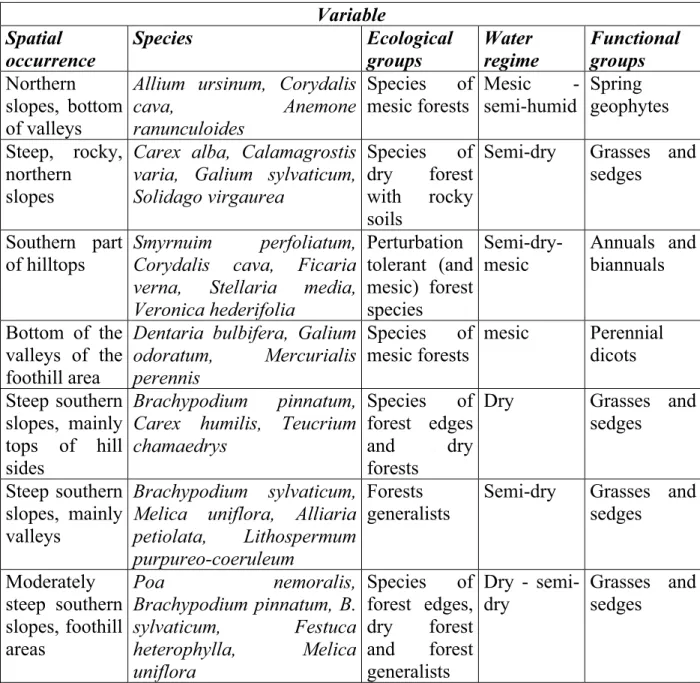
The results of grouping methods based on the floristic composition of herb layer and theeco-groups of herb layer were confused and ambiguously interpretable. Discrete groups were hardly possible to create, so transitional series was defined. This series can be divided in five groups according to the further interpretation of the results.
The spatial patterns of the types of the herb layer and the groups of the types show duality with both of the used approaches. While in the bottom of the valleys and on the slopes of northern exposition the herb layer is characterised by mesic forest species and the similar relevees form bigger patches, on the tops and on the slopes of southern exposition the herb layer is shows bigger variation in a smaller area. On the conjunction of tops and steep, rocky, concave slopes of northern exposition, the herb layer is even more variable. On the bigger part of lower altitudes, on southern slopes with shallow soils the types referring to expressly dry soils are characteristic.
According to the water-regime type, the relevees form a continuous transitional series.
The most common are the types signed by species of semi-dry sites. The pattern of the types is very variable, only smaller homogenous patches are present, which are seem to be related to milder slopes and foothill areas. Where the geomorphology is varied, the water regime can be variable either within small distances.
Based on life-forms as simple functional groups, the most prominent types are the ones with the dominance of different grasses and sedges (58 percent). This result was predicable, since the four most common species of the herb layer in the studied area are all grasses. These types are characteristic on the milder slopes of southern exposition, they can form patches on the top third of concave slopes of southern exposition. There is only one more type-group, which forms continuous patches on the bottom of valleys, the group of geophyte-dominated types. Another heterogenous type is present in the bottom of valleys either. The other types or the types under different geomorhological conditions form mosaics. In the middle of closed forest, the frequent occurrence of annual – biennial dominated types is interesting.
The herb layer is especially hard to classify, there is no sharp border between the created types. The main types and their range could be the most suitable summarised in the following table:
Table 2. Description of the main types of the herb layer.
Variable Spatial
occurrence
Species Ecological
groups
Water regime
Functional groups Northern
slopes, bottom of valleys
Allium ursinum, Corydalis
cava, Anemone
ranunculoides
Species of mesic forests
Mesic -
semi-humid
Spring geophytes Steep, rocky,
northern slopes
Carex alba, Calamagrostis varia, Galium sylvaticum, Solidago virgaurea
Species of dry forest with rocky soils
Semi-dry Grasses and sedges
Southern part of hilltops
Smyrnuim perfoliatum, Corydalis cava, Ficaria verna, Stellaria media, Veronica hederifolia
Perturbation tolerant (and mesic) forest species
Semi-dry- mesic
Annuals and biannuals
Bottom of the valleys of the foothill area
Dentaria bulbifera, Galium odoratum, Mercurialis perennis
Species of mesic forests
mesic Perennial dicots Steep southern
slopes, mainly tops of hill sides
Brachypodium pinnatum, Carex humilis, Teucrium chamaedrys
Species of forest edges and dry forests
Dry Grasses and
sedges
Steep southern slopes, mainly valleys
Brachypodium sylvaticum, Melica uniflora, Alliaria petiolata, Lithospermum purpureo-coeruleum
Forests generalists
Semi-dry Grasses and sedges
Moderately steep southern slopes, foothill areas
Poa nemoralis,
Brachypodium pinnatum, B.
sylvaticum, Festuca heterophylla, Melica uniflora
Species of forest edges, dry forest and forest generalists
Dry - semi- dry
Grasses and sedges
Summarising the previous parts, there is a possibility to create several different vegetation maps for forests of the studied area with use of different amount from different approaches. The thesis presents the floristical approach on vegetation as an example, which can be regarded as forest-type map. The used categories were created upon the floristic composition of tree and herb layer, other characteristics of the herb layer, and some data on shrub layer and site conditions. The relevees were then grouped to 58 types (33 floristically characteristic, 25 uncharacteristic), which forms main groups. (The table (Table 3.) presents the main groups.)
Table 3. The main groups and number of sub-types of floristically distinguished vegetation units of the southern part of Tés plateau:
I. Rocky forests on dry soils (6)
II-III. Beech forests (II.) and their ash – hornbeam – lime – Turkey oak secondary forests (III.) (9)
IV. Mesic ravine forest (4)
V-VI. Mesic and semi-dry forests with sessile oak (8) VII. Mixed top forests (9)
VII-VIII. Transition between top forests and downy oak forests (3) VIII. Downy oak forests (9)
VIII-IX. Transitions between downy oak forests and Turkey oak – sessile oak forests (4) IX. Turkey oak – sessile oak forests (6)
Up to this point, our overview of the area is that there are some well-definable forest types, some well-interpretable transitional series among them, and there are other transitional groups. If we look at the Tés plateau with a simplified view, we can say that there are two main types of forest in this area. One is the group of shady, mesic beech forests usually with not developed shrub layer and the secondary ash – hornbeam – lime stands; and the other is the group of shiny oak forest of the southern part with well- developed shrub layer. These latter can be subdivided on floristical basis to stands with sessile oak, which thrive on milder slopes with deeper soils, and to the stands with downy oak on steeper slopes and / or shallow soils. The ones with downy oak can be further sub- divided to closed stands and stands mosaicing with grasslands. One part of the transitions covers extended areas and bigger patches on the northern rocky, dry parts, on the steep rocky slopes, on the tops and in the valleys with deeper soil. The result is in harmony with the expectations based on climate and geomorphology.
The vegetation zones (or regions) to be found in other areas of Hungary – principally in the Északi-középhegység (North-Hungarian Mountain Range) turn up differently in the Keleti- (Eastern-)Bakony (similarly to the Déli-(Southern-)Bakony; FEKETE 1964, FEKETE – ZÓLYOMI 1966). The extended transitional belt between the beech forests and the Turkey oak forests, namely the oak – hornbeam forest belt, is missing in that sense. Oak – hornbeam forests appear only in the bottom of the deeper valleys of the foothill area. The transition belt between the beech and Turkey oak forest is different: on the fringe of the plateau it is consisted of forests mixed with common ash and lime; in southern exposition mainly with Turkey oak and downy oak, in northern exposition mainly with sessile oak and beech. Northern from the fringe the latter type is present in southern exposition, while close to the tops the Turkey oak – downy oak forests mixed with limes and ashes can be still present, but only in smaller patches. From the transitional types, floristically characteristic type is only present in the stands dominated with downy oak and Turkey oak. The sessile oak – lime – common ash stands are similar in floristic composition, shrub layer and site conditions.
Comparing the different approaches, a more detailed view to the forests is reachable. In this way some connections between site conditions and vegetation, or among the different characteristics of the vegetation can be revealed.
According to the connection between water regime and tree species composition:
1. Common ash – lime – hornbeam – beech mixed forests had the moistest soil. Hornbeam – sessile oak and beech – Turkey oak – common ash series are a bit less moist. Mixed forests with sessile oak (VII. series) and unmixed beech forests are a bit drier. Within the beech forests, the ones with manna ash and / or whitebeam (Sorbus aria) are the driest.
These stands occur close to rocks, on shallow, rocky soils, which obviously means worse water regime. Manna ash and whitebeam in the canopy layer and characteristic herb layer reflects to this fact either. Considerable part of unmixed beech forests also thrives under sub-optimal conditions (on rocks or shallow soils), which explains the above mentioned drier water-regime type.
2. In case of oak forests, downy oak and Turkey oak forests mixed with common ash and / or limes proved to be more mesic according to water regime than the less mixed stands.
This strengthen their transitional character to mesic forests.
Connection between tree species composition and stand physiognomy, the main composition types (the groups and the series) reveals 4 main physiognomic types:
1. Beech dominated forests and forests mixed with beech are usually closed (more than 80 percent). Shrub layer and secondary canopy layer is untypical, in case of existence it is formed by juvenile trees.
2. Oak forests with hornbeam proportion higher than 5 percent have characteristic structure.
These stands are higher than 15 metres, and formation of secondary canopy layer with more than 10 percent cover is restricted to these stands (occurs in 40 percent of the stands). Well-developed shrub layer can be present formed by juvenile trees. This phenomenon occurs when the proportion of hornbeam in the canopy layer has decreased for some reason. The reason of this is most probably the human impact on these forests.
In the (older) management plans there are many allusions that hornbeam is not preferred and should be omitted from the stands. The fact that in these stands following gap formation the appearing saples are hornbeams, shows that more natural like tree species composition is recovering.
3. The main characteristics of Turkey oak – sessile oak dominated forests are missing secondary canopy layer and well-developed high shrub layer (in 60 percent of stands the cover of shrub layer reaches 33 percent), which is formed by tree species instead of shrub species. In this type there are stands with different tree species (III. Downy oak dominated stands, VII. Sessile oak – common ash – lime – beech and IX. Common ash – lime – downy oak – Turkey oak series, and most of the transitions among them); but mainly with ones that let more light in the stand (oaks, common ash). Sporadically present well-developed (with more than 10 percent cover) secondary canopy layer (in 10- 15 percent), well-developed high shrub layer formed by shrub species (covers more than 33 percent in more than the half of the relevees), usually not totally closed (less then 80 percent cover) canopy layer and height between 8 and 15 metres characterise these stands.
Based on the connection of tree species composition and shrub layer:
1. Among the beech dominated stands shrub layer is present usually only in the ones containing manna ash, thriving on rocky soils. The shrub layer is formed by tree species (beech and / or many ash) exclusively in this case. In other unmixed beech forests shrub layer is totally missing.
2. In the beech stands containing higher proportion of common ash, lime and hornbeam, developed shrub layer is more common. The shrub layer is formed by juvenile individuals of mesic tree species. It shows that in these stands at least in some patches more light can penetrate into the stand than in unmixed beech forests because of the higher proportion of common ash. Mesic tree species (mainly hornbeam) characterise the shrub layer of Turkey oak – sessile oak stands with at least 5 percent hornbeam proportion either.
3. Cornus mas shrub layer is the most characteristic in the oak forests mixed with common ash and lime. In this type 65 percent of the stands having shrub layer cover more than 5 percent is like this. Both the stands mixed with common ash and lime and the shrub layer with Cornus mas are located on the tops and on sides of southern exposition directly on the fringe of the plateau.
4. Shrub layer in downy oak dominated stands is very variable. Cotinus coggygria is restricted to this tree species type as it was expected.
5. The most common species in the Turkey oak – sessile oak stands is manna ash. This can be well explained by the regular fires and clearings of these stands, which created suitable situation for the establishment and maintenance either of pioneer manna ash.
Between the floristic composition of canopy layer and herb layer it was hard to find unambiguous connections, relations, mainly because of the variable character of herb layer which is difficult to classify. There are some interesting ones presented:
1. There is no herb layer type strictly connected to oak – hornbeam forests and sessile oak – common ash – lime – beech series, which shows the transitional character of these types.
Dentaria (Cardamine) bulbifera herb layer type is the most connected to these types of stands, which reflects to the similar site condition demands of these two types. However, the Dentaria(Cardamine)bulbifera herb layer type is derived from the beech forests and it reaches high abundance in common ash – beech (hornbeam – lime) stands either, so it connects beech forests with mixed mesic forests.
2. Within the mesic forests on rocky soils there are two parallel moisture gradients in the herb and canopy layer. In the mesic end there are ravine forest like stands in bottom of valleys without oaks. The dry (xeric) end is characterised by disturbance-tolerant herb layer (e. g. Chaerophyllum temulum, Parietaria officinalis, Urtica dioica) divided further by two different canopy types – beech dominated and downy oak dominated. This herb layer type though connects ravine forests like lime – ash – beech stands with the series of common ash – lime – Turkey oak – sessile oak. One example is the common ash mixed downy oak forest characterised by strongly disturbance-tolerant herb species (like Geranium lucidum), which covers tops instead of rocky slopes. The stands of common ash – lime – Turkey oak – downy oak series are present generally with four more herb layer types. Two of these is mostly connected to this canopy type, but both of them can be abundant with other common ash mixed stands too, which means that these two canopy – herb layer types connect also beech forests with downy oak forests. Mesic species and disturbance-tolerant species are more abundant in one type, while common forest species in the other.
3. The common forest species with wide optimum of water regime occur generally with nearly all types of oak dominated stands. Melica uniflora type is the most common according the analysis, but it was noticeable that it is not homogenous. If the Melica uniflora herb layer type is considered separatelly with different tree species, and a syntetical tabella is created for them, it reveals that tree species types divide this herb
layer type to separate pieces. So, in the ash – lime – downy oak series Corydalis pumila, Geum urbanum and Viola odorata are also constant species beyond Melica uniflora. In the downy oak forests Lithospermum (Buglossoides) purpureo-coeruleum, a Geum urbanum és a Viola odorata, while in the Turkey oak stands Dactylis glomerata, Fragaria vesca, Melittis carpatica and Poa nemoralis are constant beyond Melica uniflora. Then the types of herb layer are connecting and not dividing each other.
Nudum beech forests found in the studied area are different from the ones mentioned in the forestry literature: their water regime is usually semi-dry, however the thick litter layer is missing. The soil is covered by only thin litter layer in a patchy pattern. The regularly occurring moss patches also contribute to the recognition that these beech forest hold acidophyllous character. Nevertheless, these are always adjacent to rocky forests, so they often contain herb species of rocky forests either. This altogether shows that patches with acidophyllous character and / or nutrient poor shallow soils are contributing to the diversity of beech rocky forests.
More than half of the stands of beech forests with Carex pilosa, which is known to be semi-dry according to the literature, and nearly all of beech – hornbeam – common ash stands with a high abundance of Carex pilosa proved to have mesic (or even humid) water regime. This demonstrates that the water regime of herb layer characterised by Carex pilosa is considerably influenced by the other species present in the herb layer and it can not be said directly that the stands with Carex pilosa are drier than in other beech forests.
There is a well interpretable connection between geomorphology, water regime (or herb layer type), history of the stand and ash dominance in former beech forests. Mixed beech stands with high abundance of common ash are more common from north to the fringe of the plateau. According to management plans, the shift in dominance between beech and common ash happened mainly in the beech forests with mesic-semi-humid water regime with well-developed geophyte dominated herb layer. In the same location, beech forests with semi-dry-mesic water regime and less geophytes in the herb layer were less affected by the dominance shift. In the beech forests with geophyte dominated herb layer of the inner part of the plateau, situation is a bit different. Those forest either remained beech dominated forests; either drastic changes happened due to the strong former grazing and masting, and were converted to Turkey oak – common ash or pine forests with poor, uncharacteristic herb layer. This experience draws the attention to the fact that these stands has to be more carefully reproduced or new, different methods should to be applied. In those converted beech forests one of the aims of the management should be to increase the proportion of beech.
The ambition of our days that forestry should optimise between different aims (not only to timber production), raise the question of designating the economically non manageable forests. The designation should be based on site and growth conditions.
Management plans can serve as a tool for this designation, since they contain required data (geomorphology, soil type, depth of the soil, yield class). The designation can be further specified by notes, relevees, analysis and methods (species composition, water regime, high proportion of grassland and hedge species, presence of rock forests species, history, grassland patches, not closed canopy layer) presented in this thesis.
Reviewing the data, according the profitability of forestry distinction of three categories seems to be relevant, where the middle one is a kind of mixture of the two other:
1. Areas not suitable for forest management: In these areas profitable forestry is not feasible.
No forestry management is suggested, only saniation logging is acceptable. They should be maintained as protective forests without indicated felling age. Reasons for their designation:
x canopy layer is not closed by natural reasons;
x steep or very steep slope with shallow, rocky soils (usually stands for soil protection);
x Water regime is drier than semi-dry;
x Stands in 6th yield class, where the height of canopy layer at the age of 80 years is not higher than 12 metres;
x There are rock-forests species or patches of rock forests are present.
2. Areas only limitedly suitable for forests management: These areas are not preferable for forestry. The profit is expected to be low. Stands have poor growth rates often under bad site conditions and / or are adjacent to stands not suitable for management. Forest management should be based on the “as less treatment as possible” principle. The treatments should approach to halt or even increase ecological sustainability, since multi- purpose forestry is realisable only this way. It is suggested to use selection system, selective cutting. It is important to avoid tree species selection, forming of tree composition should be led to nature, even if it contradicts with the short-term timbering expectations and directives (e. g. “too much” associate tree species in oak forests). These stands are usually highly important from the biological point of view, so moderate management contributes to the maintenance of biological values as well.
3. The remained stands are located in areas suitable for forest management, were forestry can be profitable with no doubt. Principles of their management can found in some issues published recently. Management should be carried out based on natural processes and dynamics as much as possible.
Overall forest management of the studied area is worth to rethink. Increasing the number of stands where no, or limited management used is needed. Species composition, species richness, landscape elements of most parts of the studied area altogether would deserve for protection, which has not been mentioned earlier.
Publications in the topic of the thesis:
Reviewed papers and book chapters
BÖLÖNI J., KIRÁLY G., SZMORAD F., TÍMÁR G. 1997: Új adatok az Északi-Bakony flórájának ismeretéhez. [New floristical data to the North-Bakony.] Kitaibelia 2:
13-19.
BÖLÖNIJ. 1997: Madárbirs (Cotoneaster) fajok Magyarországon. [Cotoneaster species in Hungary.] Kitaibelia 2: 174-176.
BÖLÖNI J., KIRÁLY G. 1997: A Bakony florisztikai feltárásának részeredményei.
[Preliminary results of the floristical investigations of Bakony mountains.]
Kitaibelia 2: 210-212.
KIRÁLY G., BÖLÖNI J., HULJÁK P., VOJTKÓ A. 1999: Havasi ribiszke (Ribes alpinum) In:
BARTHA D., BÖLÖNI J., KIRÁLY G. (szerk.): Magyarország ritka fa- és cserjefajai I.
Tilia 7: 144-151. [Ribes alpinum. In BARTHA D., BÖLÖNIJ., KIRÁLYG. (eds.): Rare tree and shrub species of Hungary I.]
BÖLÖNI J. 1999: Madárbirs fajok (Cotoneaster spp.). In: BARTHA D., BÖLÖNIJ., KIRÁLY G. (szerk.): Magyarország ritka fa- és cserjefajai I. Tilia 7: 193-232. [Cotoneaster species. In BARTHA D., BÖLÖNIJ., KIRÁLYG. (eds.): Rare tree and shrub species of Hungary.]
FORSTER E., BÖLÖNI J. 1999: Szirti fanyarka (Amelanchier ovalis). In: BARTHA D. - BÖLÖNI J. - KIRÁLY G. (szerk.): Magyarország ritka fa- és cserjefajai I. Tilia 7:
233-242. [Amelanchier ovalis. In BARTHA D., BÖLÖNI J., KIRÁLY G. (eds.):: Rare tree and shrub species of Hungary.]
MOLNÁR ZS., KUN A., BÖLÖNI J., KIRÁLY G. 1999: II. Az élĘhely-térképezés alkalmazása a biodiverzitás monitorozásában. In: MOLNÁR ZS., KUN A. (szerk.):
Nemzeti Biodiverzitás-monitorozó Rendszer XI. ÉlĘhely-térképezés. Scientia Kiadó, Budapest, pp. 15-19. [II. Use of habitat mapping in the monitoring of biodiverity. In: MOLNÁR ZS., KUN A. (eds.): National Biodiversity Monitoring System IX. Habitat Mapping.]
MOLNÁR ZS., BIRÓ M., BÖLÖNI J. 1999: III.2. Az élĘhely-térképezés elĘkészítése. In:
MOLNÁR ZS., KUN A. (szerk.): Nemzeti Biodiverzitás-monitorozó Rendszer XI.
ÉlĘhely-térképezés. Scientia Kiadó, Budapest, pp. 23-39. [III. 2. Preparation of habitat mapping. MOLNÁR ZS., KUN A. (eds.): National Biodiversity Monitoring System IX. Habitat Mapping.]
KUNA., MOLNÁR ZS., RÉDEIT., BÖLÖNI J., HAHN I. 1999: III.3. Az élĘhely-térképezés terepi munkái. In: MOLNÁR ZS., KUN A. (szerk.): Nemzeti Biodiverzitás- monitorozó Rendszer XI. ÉlĘhely-térképezés. Scientia Kiadó, Budapest, pp. 40-62.
[III. 3. Field works of habitat mapping. In: MOLNÁR ZS., KUN A. (eds.): National Biodiversity Monitoring System IX. Habitat Mapping.]
MEDZIHRADSZKY ZS., BÖLÖNI J., MOLNÁR ZS., KERTÉSZ M., VARGA Z., DEBRECZY ZS., MOLNÁR A. 2000: Mit tudunk a múltról? In: MOLNÁRZS., KUN A. (szerk.): 4. Alföldi erdĘssztyeppmaradványok Magyarországon. WWF füzetek 15: 20-25. [What we know about the past? In: MOLNÁRZS., KUN A. (eds.): 4. Forest steppe remnants in the Great Hungarian Plain. WWF issues.]
BÖLÖNI J. 2001: FĘbb erdĘtársulás-csoportok részaránya az Országos ErdĘrezervátum- hálózatban. [Proportion of main forest community types in the Hungarian Forest Reserves Network.] ER, Az erdĘrezervátum-kutatás eredményei 1(1): 45-52.
KUN. A., ASZALÓS R., BOTTA-DUKÁT Z., BIRÓ M., BÖLÖNI J., FEKETE G., HORVÁTH F., KRASSERD., MOLNÁRZS., RUPRECHTE., TÖRÖK K. 2002: A növénytakaró vizsgálata és leírása táji léptékben: az utóbbi évtized. In: FEKETE G. (szerk.): A Magyar Tudományos Akadémia Ökológiai és Botanikai Kutatóintézete 50 éve (1952-2002).
MTA ÖBKI Vácrátót, pp. 35-64. [Survey and description of vegetation in landscape scale: the last decade. In: FEKETE G. (ed.): Institute of Ecology and Botany of the Hungarian Academy of Sciences (1952-2002).]
OROSZI S., BÖLÖNI J. 2002: Az erdĘállomány történetére vonatkozó adatok felkutatása. In:
HORVÁTHF., BORHIDI A. (szerk.): A hazai erdĘrezervátum-kutatás célja, stratégiája és módszerei. TermészetBÚVÁR Alapítváby Kiadó, Budapest, pp. 99-108. [Searching data on the history of forest stands. In: HORVÁTHF., BORHIDI A. (eds.): Aims, strategy and methods of the study of Hungarian Forest Reserves.]
BARTHA DÉNES, BÖLÖNI JÁNOS, ÓDOR PÉTER, STANDOVÁR TIBOR, SZMORAD FERENC, TÍMÁR GÁBOR 2003: A magyarországi erdĘk természetességének vizsgálata. [Survey of the naturalness of Hungarian forests.] Erdészeti Lapok 138(3): 73-75.
Oral communications, conference papers and posters
BÖLÖNI J., KIRÁLY G. 1997: Az aktuális és potenciális vegetáció különbségei és ennek okai az Északi-Bakonyban. IV. Magyar Ökológus Kongresszus, Pécs. [Differences between actual and potential vegetation in North Bakony Mountains, Hungary. IV. Conference of Hungarian Ecologists.]
BÖLÖNI J., KIRÁLY G., MOLNÁR ZS. 1999: A kistómalmi láprét vegetációja és ennek átalakulásai az elmúlt évtizedekben. Aktuális flóra- és vegetációkutatás Magyarországon, III. Országos Konferencia, Szombathely. [Vegetation and its changes of Kistómalom rich fen meadow, Hungary. III. Conference on Actual Flora- and Vegetation Research in Hungary.]
KUNA., ASZALÓSR., BARTHA S., BÖLÖNIJ., FEKETEG., HORVÁTHF., KIRÁLYG., MÁZSA K., MOLNÁR ZS., RÉDEI T., RÉVÉSZ A., VIRÁGH K. 2001: Tájföldrajzi kapcsolódású botanikai kutatások a Dunántúli- és az Észak-magyarországi-Középhegységben. – Földrajzi kutatások, Magyar Földrajzi Konferencia, Szeged [Botanical researches connected to landscape geography in Trans-Danubian Midmountains and North Hungarian Range. Conference of Hungarian Geography.].
BIDLÓ A., BORHIDI A., BÖLÖNI J., CZÁJLIK P., FORRÓ E., HORVÁTHF., HAHN I., KOVÁCS
G., MAGLÓCZKYZS., OROSZIS., SILLERI., SOMOGYIZ., STANDOVÁRT., TRASERGY.:
Az erdĘrezervátum-kutatás módszertana. Az erdĘrezervátum-kutatás helyzete és perspektívája hazánkban, A Biológiai Tudományok Osztálya KözgyĦlési Tudományos Ülése, MTA Székház, Budapest. [Methodology of Forest Reserve Research. The state and persperctive of Forest Reserve Research in Hungary, Scientific Meeting of the Biological Science Depertment of Hungarian Academy of Sciences.]
BÖLÖNI J. 2002: A Szentgáli Tiszafás története a XVIII. század végétĘl napjainki. Aktuális flóra- és vegetációkutatás a Kárpát-medencében V., Pécs. [History of the Szentgál Yew Reserve from the end of 18th century till now. V. Conference on Actual Flora- and Vegetation Research in the Carpathian Basin.]
BÖLÖNI, J., ASZALÓS, R. 2003: Ratio of natural forest habitat types in Hungary on the basis of the National Forest Database. Towards the sustainable use of Europe’s forests – Forest ecosystem and landscape research: Scientific challenges and opportunities 25- 27. June 2003. Tours, France, Abtract Book p. 43. (poszter és összefoglaló)
MÁZSA, K., HORVÁTH, F., ASZALÓS, R., BÖLÖNI, J., BORHIDI, A. 2003: Naturalness status of forest-reserve sites on the basis of a nationwide survey in Hungary. Towards the sustainable use of Europe’s forests – Forest ecosystem and landscape research:
Scientific challenges and opportunities 25-27. June 2003. Tours, France, Abtract Book p.71. (poszter és összefoglaló)
MÁZSA, K., HORVÁTH, F., ASZALÓS, R., BÖLÖNI, J., BORHIDI, A. 2003: Az erdĘrezervátum- hálózat erdeinek jellemzése egy országos felmérés tükrében. 6. Magyar Ökológus Kongresszus, GödöllĘ. [Characterisation of forests of National Forest Reserve Network according to a country-scale survey. 6. Conference of Hungarian Ecologists.]
Manuscipt papers, scientific reports
BÖLÖNI J. 1996: A madárbirs (Cotoneaster EHRH.) nemzetség fajai a Dunántúlon.
Diplomaterv, Erdészeti és Faipari Egyetem, Növénytani Tanszék, Sopron. [The species of Cotoneaster genus in the Trans-Danubian region. Diploma work.]
BÖLÖNI J., KIRÁLY G. 1998: A Kistómalmi-láprét botanikai felmérése és rekonstrukciós tervének elkészítése. Kézirat, Sopron [Botanical survey and reconstruction plan of Kistó-malom rich fen meadow. Manuscript.].
BÖLÖNI J., KIRÁLY G. 1999: A Szentgáli Tiszafás Természetvédelmi Terület állapotfelmérése és kutatási terve. Kézirat, Sopron. [Survey and research plant of Szentgál Yew Protected Area. Manuscript.]
BÖLÖNI J. 2000: Természetes élĘhelytípusok (Annex I. - Natural Habitat Types) azonosítási lehetĘségei és korlátai az Országos ErdĘállomány Adattár alapján. Kézirat, MTA ÖBKI, Vácrátót. [The possibilites and limits of recognition of Annex I. – Natural Habitat Types based on the National Forest Database. Manuscript.]
BÖLÖNI J. 2000: A Kab-hegy erdeinek áttekintĘ leírása és értékelése. Kézirat, Vácrátót.
[Reviewing survey and analysis of forests of Kab Hill. Manuscript.]
BÖLÖNI J. 2001: Az ÉlĘhelyvédelmi Irányelv I. függelékében szereplĘ, hazánkban elĘforduló, ill. Magyarország által javasolt erdĘtársulások (élĘhelytípusok) országos szintĦ feltérképezése az Országos ErdĘállomány Adattár leválogatásának botanikai értékelésével. Kézirat, MTA ÖBKI, Vácrátót. [Country scale mapping of Hungarian and proposed Annex I. Natural Habitat Type Forests based on botanical evaluation of National Forest Database. Manuscript.]