The Halimba bauxite deposit
A halimbai
bauxit-elõfordulás
Written by — Írta
György B
ÁRDOSSYBudapest, 2007
Occasional Papers of the Geological Institute of Hungary,
volume 208
© Copyright Geological Institute of Hungary (Magyar Állami Földtani Intézet), 2007 All rights reserved! Minden jog fenntartva!
Serial editor — Sorozatszerkesztő GYULAMAROS
Technikal editor — Műszaki szerkesztő OLGAPIROS, DEZSŐSIMONYI
DTP
OLGAPIROS, DEZSŐSIMONYI
Cover design — Borítóterv DEZSŐSIMONYI
Published by the Geological Institute of Hungary — Kiadja a Magyar Állami Földtani Intézet
Responsible editor — Felelős kiadó LÁSZLÓKORDOS
director — igazgató
This book has been subsidized by the Committee on Publishing Scientific Books and Periodicals of Hungarian Academy of Sciences
A könyv a Magyar Tudományos Akadémia Könyv- és Folyóiratkiadó Bizottságának támogatásával készült
ISBN 978-963-671-260-0
Contents
The Halimba bauxite deposit
Description of the scientific results . . . . Introduction . . . . The methods of evaluation . . . . Footwall and hanging wall formations . . . . The footwall . . . . The cover . . . . Extent and thickness of the bauxite deposit . . . . Tectonic conditions . . . . Sedimentologic features of the deposit . . . . Petrographic composition of the bauxite sequence and its structure . . . . The main and accessory chemical components of the Halimba deposit . . . . The trace elements of the Halimba bauxite deposit . . . . The mineralogical composition of the deposit . . . . The origin of the Halimba bauxite . . . . Applied geology . . . . Experiences of the surface exploration . . . . Underground exploration of the deposit . . . . Resource estimations . . . . Geomathematical and informatical experiences . . . . Hydrogeologic experiences . . . . Summarizing ideas and explanations . . . .
* * *
A halimbai bauxit-elõfordulás
Földtudományi rész . . . . Bevezetés és célkitûzés . . . . A kiértékelés módszerei . . . . A fedõ- és feküképzõdmények értékelése . . . . A feküképzõdmények . . . . Fedõ képzõdmények . . . . A bauxitelõfordulás és a bauxittestek kiterjedése, vastagsága . . . . Tektonikai felépítés . . . . A bauxitösszlet szedimentológiai felépítése . . . . A bauxitösszlet kõzettani felépítése és szövete . . . . A bauxitösszlet fõ és járulékos kémiai komponensei . . . . A bauxitösszlet nyomelemei . . . . A bauxitösszlet ásványtani felépítése . . . . A bauxit-elõfordulás kialakulása . . . .
7 7 7 8 8 9 10 16 18 19 24 45 48 49 54 54 58 61 67 68 69
73 73 73 73 73 74 75 78 79 80 84 95 99 99
Alkalmazott, gyakorlati rész . . . . A felszíni bauxitkutatás módszertani tapasztalatai . . . . A föld alatti termelési kutatás tapasztalatai . . . . A készletszámítások tapasztalatai . . . . Geomatematikai, számítástechnikai és informatikai tapasztalatok . . . . Hidrogeológiai tapasztalatok . . . . Összefoglaló értékelés . . . . Felhasznált irodalom . . . .
103 103 108 110 114 115 116 117
Description of the scientific results . . . . Introduction . . . . The methods of evaluation . . . . Footwall and hanging wall formations . . . . The footwall . . . . The cover . . . . Extent and thickness of the bauxite deposit . . . . Tectonic conditions . . . . Sedimentologic features of the deposit . . . . Petrographic composition of the bauxite sequence and its structure . . . . The main and accessory chemical components of the Halimba deposit . . . . The trace elements of the Halimba bauxite deposit . . . . The mineralogical composition of the deposit . . . . The origin of the Halimba bauxite . . . . Applied geology . . . . Experiences of the surface exploration . . . . Underground exploration of the deposit . . . . Resource estimations . . . . Geomathematical and informatical experiences . . . . Hydrogeologic experiences . . . . Summarizing ideas and explanations . . . .
The Halimba bauxite deposit
7 7 7 8 8 9 10 16 18 19 24 45 48 49 54 54 58 61 67 68 69
The author of this monography participated in the geologic exploration and the evaluation of the Halimba deposit. His first goal is to present the scientific experiences of his researches on the deposit.
His second goal is to outline the methods applied for the exploration, the resource estimation and the mining-geologic evaluation of the deposit. Some new methods developed by the author and his col- leagues are described in more detail.
In the first part of the monography the author presents the deposit-model and describes its main properties. In the second part the exploration process and the resource estimation methods are described and the results of surface and underground exploration are compared.
* * *
The author wishes to express his sincere gratitude for the help he received from the mining engi- neers and the geologists of the Halimba mine and the former chief geologists F. Zenkovics, B. Bíró, T. Erdélyi and K. Mérai. He is particularly indebted to B. Jankovics, J. Tiszay, G. Varga and I. R.
Szabó for their precious advises and proposals to the manuscript.
The visits of the mine and the discussions with I. Kis chief engineer and manager of the mine were very helpful for the author. The author is very thankful to J. Haas for his help in clarifying the stratigraphic position of the immediate footwall rocks.
The author is very thankful to O. Piros and D. Simonyi for the very precious editorial work.
Finally he expresses his thanks to the presidency of the Hungarian Academy of Sciences for their financial help.
Description of the scientific results
Introduction
The Halimba bauxite deposit is one of the largest in Europe. It is continuously mined by underground methods since 1951.The Halimba bauxite deposit is situated in the western part of Hungary called Trans- danubia, more closely in the south-western part of the Bakony Mountains (Figure 1). It is a karst-type deposit with several particular features.
The methods of evaluation
The content of the monography is based on several hundred visits of the mine, where the author carried out direct observations of the ore body and sampling for different laboratory measurements. The samples are stored in the Department of Mineralogy of the Museum of Earth Sciences, at Budapest.
Figure 1. Geologic environment of the Halimba bauxite deposit
1 — bauxite sequence on the surface and buried, 2 — Late Triassic carbonate sediments on the surface, 3 — main fault line
1. ábra. A halimbai bauxitelõfordulás földtani környezete 1 — bauxitösszlet a felszínen és felszín alatt, 2 — felsõ- triász korú karbonátos képzõdmények a felszínen, 3 — fõ törésvonal
Figure 2.Sections of the Halimba deposit, distinguished by their geologic features
1 — number of the section, 2 — contour of the section, 3 — strike-slip faults, 4 — complex tectonic zone
2. ábra. A halimbai bauxitelõfordulás teleptanilag megkülönböz- tethetõ részterületei
1 — a részterületek száma, 2 — a részterületek határai, 3 — oldalirányú töréses elmozdulások, 4 — összetett tektonikai zóna
More than 2200 surface boreholes were drilled on the deposit — 80 to 460 metres deep — so far. Co-ordi- nates of their locations, descriptions of the cores and chemical analyses of the bauxite were collected by the author and stored in a computerized data base. The SPSS statistical programme package was applied to carry out different one- and multivariate statistical calculations. A large number of variograms was calculated by the Variowin programme. The possibility theory was applied for the quantitative evaluation of uncertainties and transitions, particularly fuzzy arithmetic and fuzzy logic. The Bayes concept of probability has been applied to evaluate the completeness of exploration results.
Particular attention was paid to the scale-factor, as the variables evaluated were rather sensible to this effect.
For this purpose the deposit was divided by the author into 28 sectors each characterized by different proper- ties such as bauxite thickness, chemical composition and facies of deposition etc. (Figure 2). First the average properties of the sectors were determined, followed by an evaluation of the borehole results separately.
Finally variations within the boreholes were evaluated.
Footwall and hanging wall formations
The footwall
The footwall of the Halimba deposit consists of carbonate rocks of Late Triassic and Early Jurassic forma- tions. Their age and lithofacies was determined separately in each borehole and in the galleries of the under- ground mine. Based on these data MÁTÉFI(2002) constructed a map of the immediate footwall formations. He distinguished the Main Dolomite Formation, the Kössen Formation, the Dachstein Limestone Formation and the Lower Liassic Kardosrét Limestone Formation. The map of Mátéfi was recently modified and completed by the results of new boreholes and by stratigraphic studies (Figure 3).
The basement of the Halimba basin consists of the Norian Main Dolomite Formation, having an estimated thick- ness of several hundred metres. It is the immediate footwall in the western and southern part of the deposit. The Norian–Rhaetian Kössen Formation con- sists of limestone and marl. It is the immediate footwall in the central and eastern part of the deposit, with a thick- ness of 30 m to 50 m. Its upper part is eroded. It is covered by the Rhaetian Dachstein Limestone Formation. The estimated thickness of the formation is 20 m to 200 m. The limestone is character- ized by many cavities and some larger caverns filled by bauxitic clay and clayey bauxite.
The southern part of the deposit —–
called the Cseres ore body — was initial- ly explored in the fifties and sixties. The immediate footwall was described as the Main Dolomite Formation. In 1996 sev- eral boreholes were drilled in this sector, between the older boreholes with the aim to find remaining ore. Surprisingly, in all these boreholes Dachstein Lime- stone was found to be the immediate footwall. To solve these contradictions microscopic studies were carried out by Haas J. He found that the limestone has a typical ooidal and oncoidal texture and its microfossils indicate its Lower Liassic age, the Kardosrét Limestone Formation.
In the same time he observed a signifi- cant diagenetic dolomitization of the
Figure 3.Immediate foot-wall sediments of the Halimba deposit
1 — contour of the bauxite deposit, 2 — Rhaetian Dachstein Limestone Formation, on its top Hettangian Kardosrét Limestone Formation, 3 — Rhaetian–
Norian Kössen Formation, limestone and marl, 4 — Norian Main Dolomite Formation, 5 — strike-slip faults, 6 — complex tectonic zone, 7 — transversal faults
3. ábra.A halimbai bauxitelõfordulás közvetlen fekü képzõdményei 1 — a bauxitelõfordulás körvonala, 2 — rhaeti Dachsteini Mészkõ Formáció, felsõ részén alsó-liász Kardosréti Mészkõ Formáció, 3 — rhaeti–nori Kösseni Formáció, mészkõ és márga, 4 — nori Fõdolomit Formáció, 5 — oldalirányú törésvonalak, 6 — összetett tektonikai zóna, 7 — haránt törések
limestone (Haas personal communication 2007). It is very likely that this dolomitization led to the erroneous assumption that the footwall belongs here to the Main Dolomite Formation.
The findings of Prof. Haas were corroborated by two boreholes located in the central part of the deposit (Halimba H–1457, H–1460), were the Kardosrét Limestone was found to be the imme- diate footwall. Additional microscopic investigations were carried out by Haas on samples taken from the Halimba Hgh–11 hidroge- ologic borehole, situated in the northern part of the deposit. He found that the upper 100 metres interval of the immediate footwall
limestone belongs to the Kardosrét Formation and only the lower part can be accepted as Dachstein Limestone. Diagenetic dolomitization was observed by him in the samples. There is continuity between the Dachstein Limestone and the Kardosrét Limestone. These new findings changed our former assumptions concerning the footwall formations of the deposit. It looks alike that in many places instead of the Dachstein Limestone the Lower Liassic Kardosrét Limestone is the immediate footwall, underlain by the Dachstein Limestone.
The surface of the footwall formations is karstified. Karstic-erosional valleys, elongated in north- east/south-west direction occur on the western side of the deposit (Figure 4), filled by bauxitic rocks. A further peculiar feature of the footwall surface is the presence of 20–60 m deep sinkholes, filled by bauxite. They have circular or oval contours, with an area of 1000 m2 to 1700 m2. They are situated in the northern part of the deposit, as indicated on the Figure 4.
The cover
The western and northern part of the deposit is covered by Late Cretaceous (Santonian) marl and con- glomerate of carbonate rock debris, called the Csehbánya Formation. It is of fluvial origin. Stratigraphic stud- ies indicate that originally the entire bauxite deposit was covered by this formation, but has been entirely eroded in the south-eastern part of the deposit during the Palaeocene and Lower Eocene emersion. The actu- al contours of the remaining Santonian sediments are indicated on Figure 4. The estimated thickness of this formation is about 50 m.
In the north-western part of the deposit the Csehbánya Formation is overlain by the sediments of the Ajka Coal Formation, also of Santonian age. They contain brown coal beds, accompanied by clay, marl and sand- stone. Because of the erosion of its upper part the original thickness of the formation is not known. Cam- panian limestones and sandstones were preserved in some tectonic grabens to the west of the Halimba deposit.
The area of the Halimba Basin was emerged during the Palaeocene and Lower Eocene. After the erosion mentioned above a flat abrasional surface was formed. Transgression of Middle Eocene sediments followed from the north-west. The transgression started with a rise of the groundwater level. Marshes were formed in small basins and creek-valleys, filled by grey to black pyritic-markasitic clay and clayey lignite of 1 m to 5 m thickness. At the beginning of the transgression clayey marl and marl were deposited, called the Darvastó Formation. It is followed by Nummulitic limestone of shallow marine facies, called the Szõc Limestone Formation (KECSKEMÉTI2005).
It was presumed by some geologists, that during the Palaeocene – Lower Eocene emersion bauxite was deposited on the surface of the Santonian sediments and was covered by the Middle Eocene transgression.
This presumption was not confirmed by the borehole sequences and by the underground mining operations.
In the northern part of the deposit the Szõc Limestone Formation is overlain by the Padrag Marl Formation of Bartonian–Priabonian age. This formation is also partly eroded. The youngest sediments in the Halimba Basin are sand, clay and gravel of Pleistocene age.
Figure 4. The Cretaceous cover of the Halimba deposit and main morphologic features of the footwall surface
1 — Halimba deposit, 2 — Szõc deposit, 3 — Malom Valley deposit, 4 — contours of the bauxite, 5 — karstic-tectonic “wells” filled by Cretaceous sediments, 6 — extent of the Late Cretaceous cover, 7 — karstic-erosional “valleys” of the footwall surface, 8 — strike slip faults, 9 — borders of the deposit-areas
4. ábra. A halimbai bauxitelõfordulás kréta fedõjének elterjedése és a fekü mor- fológiája
1 — a halimbai bauxitelõfordulás, 2 — a szõci bauxitelõfordulás, 3 — a malom-völgyi bauxitelõfordulás, 4 — a bauxittelepek körvonala, 5 — felsõ-kréta rétegek karsztos- tektonikus beszakadásai, 6 — felsõ-kréta fedõrétegek elterjedése, 7 — a fekü fel- színének karsztos-eróziós völgyformái, 8 — oldalirányú törésvonalak, 9 — az elõfor- dulások határvonala
Extent and thickness of the bauxite deposit
The deposit has an 8 km2extent. It is 4 km long in north-eastern direction and perpendicularly 1.5 to 2.5 km wide. A main tectonic line closes the deposit on its north side. The deposit is divided into two parts by another tectonic line, having a west–north-west/ east–south-east direction (Figure 2).
One kilometre to the south-east of the deposit is the northern end of the Malom Valley group of deposits char- acterized by lenticular ore bodies. To the south of the Halimba deposit is situated the Szõc group of deposits with similar lenticular ore bodies (Figure 4). Their relationship to the Halimba deposit will be discussed in the genetic chapter (The origin of the Halimba bauxite).
The contour of the Halimba deposit is rather irregular, sinuous. Two deep embayments of the contour occur at the north-western edge of the deposit (Figure 2). Evaluation of the exploration data and construction of geologic profiles revealed that they are erosional valleys cut into the bauxite deposit. The valleys are 10 m to 20 m deep and they are filled by coarse grained fluvial sediments of the Santonian Csehbánya Formation.
They were formed after the emersion of the Halimba Basin during the Santonian.
The boreholes and the mining operations revealed in the northern part of the deposit five spots of 50 m to 100 m diameter, where the bauxite sequence was entirely lacking. Their places are indicated on Figure 2. They correspond to local eminences of the footwall rocks. They should not be confounded with the small tectonic grabens occurring in other parts of the deposit, being also barren spots.
The determination of the surface of the deposit is simple where it is covered by Middle Eocene sediments.
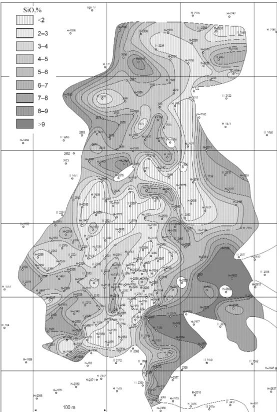
On the other hand, it is quite difficult at places where the Csehbánya Formation covers the deposit and where the top of the deposit consists of very similar coarse grained detritic carbonate rocks that are conglomerates or conglobreccias. In this case a right division can be made by the chemical composition of the rocks. The basic assumption is that the rocks of the bauxite sequence contain bauxite minerals, in our case boehmite or gibb- site. The Al2O3/SiO2ratio must be in this case more than 0.85. Thus the surface of the bauxite sequence can be traced were the ratio falls below 0.85. This distinction worked well in all places where the upper border of the bauxite sequence was uncertain.
The main bauxitic rock types have different extensions within the deposit. This is shown on Figure 5. Only the bauxitic clay extends over the entire area of the deposit. The clayey bauxite occupies a smaller area. It is continuous in the central part and forms isolated lenses within the bauxitic clay in the external parts of the deposit. The bauxite occupies only the central part of the deposit, where it is continuous. The contours of the bauxite are extremely sinuous, much more irregular than the external contours of the deposit. All these fea- tures are closely related to the origin of the deposit.
A characteristic feature of the deposit is the presence of detritic carbonate sediments in the south-western part of the deposit, called Cseres Division. They fill a south-west/north-east oriented valley of the footwall surface and they consist mainly of carbonate conglomerate, breccia and car- bonate aleurite. Layers of high grade bauxite were found within this sequence. The spatial position of these layers being quite regular it was decided that the boreholes must not reach the footwall rocks; it is enough to sample the bauxite and to determine the position of the bauxite layers. For this reason it was not possible to determine the entire thickness of the bauxite sequence in this area (sector No. 13 on Figure 2). It is estimated by the author to be about 60 m to 100 m.
The total thickness of the bauxite sequence was determined in all other sectors of the deposit and the main statistical parameters of the thickness were calculated. The values of the first 14 sectors are shown on Table 1. The averages for the sectors vary from 7.2 m to 32.0 m, but in most sectors it is between 10 m and 20 m. The median and the
“trimmed mean” (diminished by 5% external val- ues) do not differ significantly from the mean. The most frequently occurring value — the mode — shows also similar values. This and the values of
Figure 5. The main bauxitic rock-types of the Halimba deposit 1 — bauxite, 2 — clayey bauxite, 3 — bauxitic clay, 4 — borders of the petrographic units, 5 — strike-slip faults
5. ábra. A halimbai bauxitelõfordulás kõzettani felépítése 1 — szorosan vett bauxit, 2 — agyagos bauxit, 3 — bauxitos agyag , 4 — kõzettani egységek határai, 5 — oldalirányú törésvonalak
the “skewness” show that the distribution of the thickness is only slightly asymmetric. The direction of the asymmetry is positive, that is towards the larger thicknesses. The maximum and minimum thicknesses, meas- ured in the boreholes are also indicated on Table 1. The maximum thickness is 77.0 m in a borehole of the 12th sector. The minimum values vary between 3 m and 22 m.
The uncertainty of the average values for the sectors is expressed by confidence intervals, calculated on the 95% level of confidence. They are also indicated on Table 1. They are considered to be relatively short. The variability of the thickness is expressed by the standard deviation and by the coefficient of variation. The val- ues of this coefficient vary from 26% to 54%, being smaller than the similar values of the bauxite (sensu stric- to).
Similar statistical values were detected in the northern part of the deposit (sectors 16–27). Here again the largest mean thickness occurs in the “valleys” mentioned before.
An isoline map was constructed by the author for the southern part of the deposit taking into account the thickness of the bauxite sequence measured in the boreholes (Figure 6). The thickness is 5 m to 20 m over large part of this area. It increases to 60–100 m in the western part as a filling of the “valley” mentioned above. There is a much smaller and very sinuous area in the eastern part where the thickness increases to 30–40 m. How to interpret this distribution? The texture and the structure of the bauxite sequence indicate a fluvial origin. In the time of the arrival of the bauxitic material the Halimba Basin was a shallow trough. The filling of the above mentioned valley was also a fluvial process.
PATAKIet al. (2002) supposed that it was rather a talus. I do not agree with this opinion. First the morphol- ogy of the Halimba Basin in the time of bauxite accumulation was gentle, only low hills occurred on the rim of the basin. This morphology could not allow the accumulation of such a thick sedimentary sequence. The elongated form of the valley filling does not correspond to a talus cone. Thus I prefer the accumulation by a fluvial process, which was characterized by intermittent floods and longer breaks. The thicker sinuous baux- ite sequence in the east accumulated in a different way. I presume that it is of alluvial origin, accumulated dur- ing short floods.
Let us evaluate now the thickness distribution of the bauxite (sensu stricto). As a first step no significant dif- ference of thickness was found between the part of the deposit covered by Senonian sediments and the south- eastern part covered by Middle Eocene ones. All sedimentary features of the Senonian sediments indicate that they covered initially the entire deposit, but their south-eastern part was eroded during the Palaeocene – Lower Eocene emersion. It is surprising, but we must accept that the erosion did not touch significantly the bauxite sequence.
The author calculated the average bauxite thickness for all sectors of the deposit. As the bauxite does not cover the entire area of the sectors, only boreholes dissecting bauxite were included into the calculation.
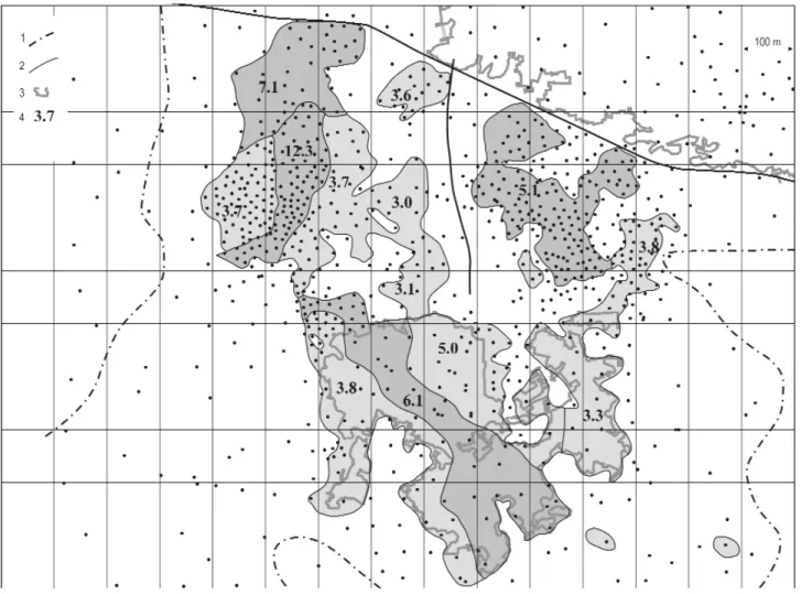
Figure 7 represents the extent of the bauxite bodiesin the southern part of the deposit and their average baux- ite thickness. Three large bauxite bodies occur in this area connected by narrow necks. In the south is the Cseres bauxite body. I distinguished in it four sectors characterized by slightly different facies-properties. The bauxite body called Halimba II SWis situated in the “valley” mentioned above several times. Here again four sectors could be distinguished. The third large bauxite body is situated in the north-eastern part of the area.
It could not be subdivided into sectors. Three smaller bauxite bodies can be seen in the central part of the study area. Finally another smaller elongated bauxite body occurs at the eastern rim of the area. This is not a random distribution, but it is the consequence of the accumulation process of the bauxite. The northern part
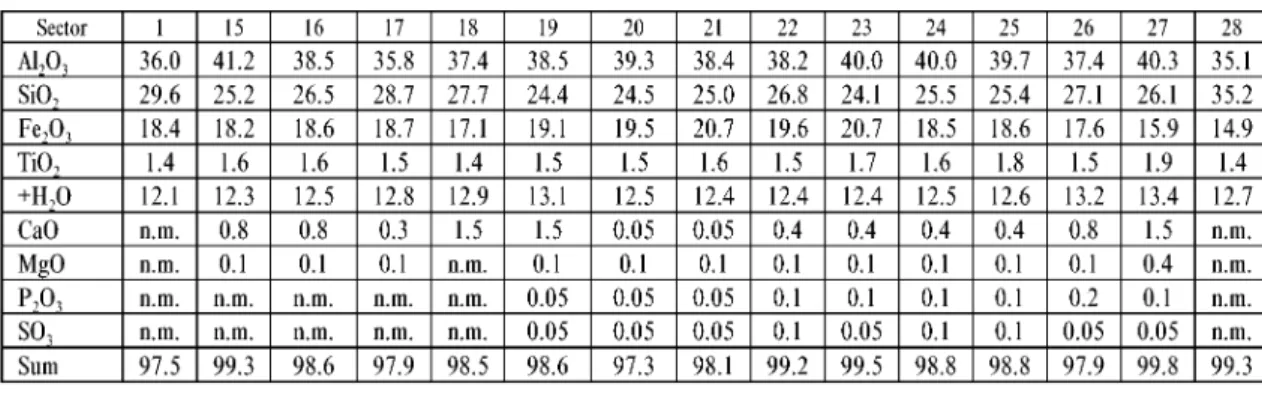
Table 1.Statistical parameters of the thickness of the bauxite-sequence in the sectors of the southern part of the Halimba deposit
of the deposit is less dissected than the southern one. It forms one huge, single bauxite body, having very sin- uous contours (Figure 5).
The statistical parameters of the bauxite have been calculated in the same way as for the entire bauxite sequence (Table 2): The average thickness of the bauxite varies from 1.5 m to 12.3 m. It is largest in the elon- gated central sector of the western bauxite body and in its northern continuation (Figure 7). Relatively large is the thickness of the central sector too in the Cseres bauxite body. This thickness configuration has a similar-
Figure 6. Thickness of the bauxite sequence in the southern part of the Halimba deposit
1 — contour of the bauxite sequence, 2 — excavated bauxite bodies, 3 — fault lines, 4 — surface boreholes 6. ábra.A bauxitösszlet vastagsága a halimbai elõfordulás déli részén
1 — a bauxitösszlet határa, 2 — kitermelt bauxittestek, 3 — törésvonalak, 4 — felszíni fúrások
Table 2.Statistical parameters of the bauxite thickness in the sectors of the southern part of the Halimba deposit
ity with the western bauxite body. In both cases the central sector is interpreted as a river-bed facies, flanked on both sides by levee facies of the river bank, characterized by smaller thickness. It is not clear whether these two facies configurations were initially connected or not. It is quite possible that they were connected to the west, but the bauxite layer was destroyed by the coarse carbonate sediments arriving from the south-west. We will return to this problem in the following chapters.
It is very likely that the two elongated sectors at the eastern part of the study area (sectors 2, and 6) are fill- ings of a narrow creek cut in the underlying clayey bauxite and bauxitic clay. The thin bauxite lenses in the central part of the study area are interpreted as very shallow valleys cut into the underlying clayey bauxite layer. The third large bauxite body in the north-east has a medium average thickness (see Figure 7). It is inter- preted as an alluvial – flood basin accumulation. Recent observations in the galleries of this bauxite body con- firmed this assumption, the bauxite having a coarse detrital structure.
In most sectors there is only a small difference between the mean, the trimmed mean and the median (Table 2). This is valid for the mode also, except for the central sector in the western part of the area, where the most frequent thickness — the mode — is round 20 m. Similarly a higher mode was found in the central sec- tors of the Cseres deposit. It is interpreted as a particular feature of the river-bed facies. The maximum values of the bauxite thickness are 36.1 m and 31.0 m. They correspond to local depressions of the footwall surface.
The statistical skewness is positive in all sectors. The asymmetry is only weak as the skewness values vary between 0.49 and 2.06.
The variability of the bauxite thickness has been expressed by the standard deviation and by the coefficient of variation (Table 2). Here again the latter one is more suitable for a comparison of the sectors. The variabili- ty of the bauxite is two to three times higher than for the entire bauxite sequence (see Tables 1 and 2), it varies from ±49.7% to 104.7%. The spatial distribution of the coefficient of variation is presented on Figure 8. It is highest in the north-eastern part of the study area. This is in good correspondence with the facies of accumu- lation of these two bauxite bodies, outlined above. The variability of the bauxite thickness diminishes from the
Figure 7.Average bauxite thickness of the sections in the southern part of the Halimba deposit
1 — contour of the bauxite sequence, 2 — fault lines, 3 — excavated bauxite bodies, 4 — average bauxite thickness (metre) 7. ábra.A részterületek átlagos bauxitvastagsága a halimbai elõfordulás déli részén
1 — a bauxitösszlet határa, 2 — törésvonalak, 3 — kitermelt bauxittestek, 4 — átlagos bauxitvastagság (méter)
east to the west in both the Cseres and the Halimba II SW bauxite bodies. The smallest variability was found in the central part of the study area with ±49.7% to 52.5%, corresponding to the quiet conditions of bauxite accumulation at these places.
The uncertainty of the mean values is expressed by the confidence intervals at 95% level of confidence (Table 2). The length of the confidence interval is 2% to 4%. These values express acceptable reliability of the means, taking into account the very high variability of the bauxite thickness.
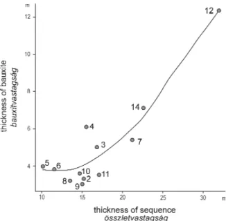
Surface exploration and mining experiences indicat- ed that there is a certain correlation between the thick- ness of the bauxite and of the entire bauxite sequence.
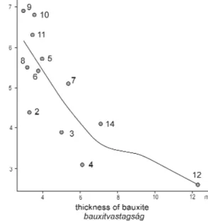
To clarify this assumption a scatter plot was construct- ed for the mean values of the sectors (Figure 9).There exists a non-linear correlation that is closest where the average bauxite thickness is more than 5 m. Below this value the correlation diminishes and finally van- ishes.
A further scatter plot was constructed to study the correlation between the average bauxite thickness of the sectors and the standard deviation (Figure 10). The
Figure 8. Coefficient of variation of the bauxite thickness in the southern part of the Halimba deposit
1 — numbers of the sectors, 2 — contour of the bauxite sequence, 3 — fault lines, 4 — excavated bauxite bodies, 5 — coefficient of varia- tion of the bauxite thickness (%)
8. ábra. A bauxitvastagság relatív szórása a halimbai elõfordulás déli részén
1 — a részterületek száma, 2 — a bauxitösszlet határa, 3 — törésvonalak, 4 — kitermelt bauxittestek, 5 — a bauxitvastagság relatív szórása (%)
Figure 9.Correlation of the sequence thickness and of the bauxite thickness (calculated from the sector averages).
The numbers indicate the sectors
9. ábra. Az összletvastagság és a bauxitvastagság korrelá- ciója (a részterületátlagokból számolva). A számok a részterületeknek felelnek meg
positive correlation is clear, but is again of non-linear type.
The correlation can be modelled by a logarithmic function.
In this case the correlation is closest in the interval of small bauxite thickness.
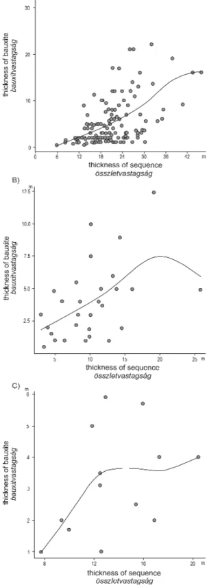
Further scatter plots were constructed to study the cor- relation of the bauxite thickness and bauxite sequence thickness on the level of individual boreholes. The correla- tion is much less close than for the sector averages, but it can be recognized by the “LLR-smoother curves”, con- structed additionally. The borehole values of three selected sectors are shown on Figure 11. The reliability of these scat- ter plots depends on the number of the boreholes, indicat- ed on the figures. The very loose and non-linear type of these correlations can be well recognized.
A further way to study and to express the spatial vari- ability of the bauxite thickness is furnished by the con- struction of variograms and particularly by the variogram models expressing the ranges of influence of the bauxite thickness. Several hundred variograms were constructed by the author, by applying the matheronian method.
Principally isotropic variograms were calculated, based on the values of 509 boreholes. The results are presented on Figure 12. Let me stress that shorter ranges of influ- ence express higher variability in the given sector. The most important finding was that the ranges of influence are very different, even within one bauxite body. This is a confirmation for the necessity and usefulness of the dis- tinction of sectors within the bauxite bodies. But even these values are averages! Local ranges of influence may significantly deviate from these average values. This was confirmed in many places of the recent mining opera- tions. The longest ranges of influence reach 50–65 m and the shortest ones are shorter than 10 m (exact values could not been determined). In other bauxite deposits of
Figure 10.Correlation of the bauxite thickness with its standard deviation (calculated from the sector averages).
The numbers indicate the sectors
10. ábra. A bauxitvastagság és szórásának korrelációja (a részterület átlagokból számolva). A számok a részterü- leteknek felelnek meg.
Figure 11. Correlation of the sequence thickness and of the bauxite thickness in three sectors
A = eastern main bauxite body (sector No. 7, 133 bore- holes), B = western edge of the Cseres bauxite body (sector No. 5, 29 boreholes), C = central bauxite body (sector No. 8, 13 boreholes). The points indicate boreholes
11. ábra.Az összletvastagság és a bauxitvastagság kor- relációja három részterületen.
A = keleti fõtelep (7. részterület, 133 fúrás), B = Cseres nyu- gati széle (5. részterület, 29 fúrás), C = középsõ telep (8.
részterület, 13 fúrás). A pontok fúrásoknak felelnek meg
Hungary 50 m to 100 m long ranges of influence were determined, that is longer ones, than in the Halimba deposit.
A further aspect of spatial variability is the contour of the bauxite bodies. Sinuous, complicated contours indi- cate a higher areal variability of the bauxite bodies. The contours in the eastern part of the study area are more sinuous than in the western part (Figure 12). This is only an empiric opinion. It can be quantified by measur- ing the surface of the different bauxite bodies. The outlines of the corresponding squares can be easily calcu- lated. Than the length of the corresponding bauxite contour is calculated. Dividing this value by the outline of the square gives a ratio, being obligatory more than one. The larger the ratio the higher is the areal variabil- ity of the given bauxite body.
Summarizing our experiences, the bauxite bodiesare the basic units of our investigation. Differences in the facies of accumulation and in some properties were the base for subdividing the bauxite bodies into sectors.
The results outlined above confirmed this assumption. A further distinct step of the investigation is the scale of the boreholes, evaluated separately. The final step is the study of the bauxite and of the entire bauxite sequence within one selected borehole. This principle will be followed in the further evaluations of this monography.
Tectonic conditions
All exploration reports of the Halimba deposit contain the chapter of the Tectonic conditions. The authors of these reports agreed that the main tectonic elements in the Halimba Basin are fracture lines. They are most- ly normal faults, but some reversed faults were also detected.. The most frequent directions of the tectonic lines are NNW/SSE and NNE/SSW.
Figure 12.Ranges of influence of the bauxite thickness calculated from the variograms in the southern part of the Halimba deposit 1 — contour of the bauxite sequence, 2 — contours of the sectors, 3 — ranges of influence (metre), 4 — number of boreholes involved into the calculation
12. ábra.A bauxitvastagság variogramokból számított hatástávolságai a halimbai elõfordulás déli részén
1 — a bauxitösszlet határa, 2 — a részterületek határai, 3 — hatástávolság (méter), 4 — a számításba bevont fúrások száma
ERDÉLYIM. (1965) when evaluating the tectonic structure of the deposit started from the assumption that the base of the Middle Eocene formations was a flat, nearly horizontal abrasional surface. All tectonic move- ments were related by him to this base-surface. The author of this monography applied also this concept with a small modification. He assumed that the base-surface had a slight (2–4°) dip in north-west direction. A large number of so-called tectonic and palaeogeographic profiles were constructed by him, related to the above mentioned base-surface. The profiles were very suitable to detect tectonic movements that occurred before the formation of the base-surface. Several older fault lines were detected together with the general north- western dip (5–10°) of the Senonian cover. Erdélyi found also some additional fault lines of east/west and north/south direction.
The most important tectonic line in the Halimba Basin cuts the bauxite deposit on its northern side.
MÉSZÁROS(1982) detected that a lateral movement of about 2 km occurred along this line. This right-side movement pushed the rocks in east–south-east direction. The displacement occurred after the Eocene, accord- ing to Mészáros. In a later publication (MÉSZÁROS1983) he assigned an intra Sarmatian (Late Miocene) age for the tectonic movement. According to MÁTÉFI(2002) the displaced Triassic and Creatceous formations can be found — together with the bauxite sequence to the south-east of Padragkút village.
A second fault-line, almost parallel to the above mentioned one cuts the deposit into a northern and south- ern part (see Figure 2). A right-side horizontal displacement of about 200 m to 300 m occurred along this fault line. It seems to be older than the northern one, as the Middle Eocene cover was not involved into the dis- placement. Another older fault line was detected during the exporation of the last years, starting in the south at the Cseres bauxite body and ending by reaching the above mentioned second fault line. It certainly had an important morphologic role during the accumulation of the bauxite sequence, as it clearly separates the baux-
Figure 13.Areal distribution of the rock types in the southern part of the Halimba deposit
1 — bauxite SiO2<4%, thickness >10 metres, 2 — bauxite SiO2<4%, thickness <10 metres, 3 — bauxite SiO24–10%, 4 — clayey bauxite, 5 — bauxitic clay, 6 — detritic carbonate rocks, 7 — main fault lines, 8 — older fault line, 9 — contour of the extent of detritic carbonate rocks, 10 — contour of the bauxite sequence, 11 — contour of the bauxite bodies, 12 — excavated bauxite bodies, 13 — surface boreholes 13. ábra. A bauxitösszlet kõzetfajtáinak elterjedése a halimbai elõfordulás déli részén
1 — bauxit, SiO2<4%, vastagság >10 méter, 2 — SiO2<4%, vastagság <10 méter, 3 — bauxit SiO24-10%, 4 — agyagos bauxit, 5 — bauxi- tos agyag, 6 — karbonáttörmelékes kõzetek, 7 — fõ törésvonalak, 8 — idõsebb törésvonal, 9 — a karbonáttörmelékes kõzetek elter- jedésének határa, 10 — a bauxitösszlet határa, 11 — a bauxittestek körvonala, 12 — lefejtett terület, 13 — fúrás
ite bodies of the eastern side, from those of the western side. Mainly bauxitic clay and clayey bauxite occur along this fault line in a strip of 100 m to 150 m width (see Figure 13 and chapter Petrographic composition of the bauxite…).
An important tectonic line was detected by mining exploration and the mining operations along the west- ern side of the deposit, having a NNE/SSW direction (Figure 2). It is supposed to be of late Kimmeridgian age.
Compressional movements occurred along it. The displacement continued during the Laramian orogeny and a several metres broad tectonic zone was formed, filled by a fault breccia, consisting of bauxite debris, cement- ed by bauxitic clay. The main reverse fault line is dissected by a number of normal faults of north-west/south- east direction. 10 m to 40 m of horizontal displacement occurred along these fault lines. They were formed probably during the Pyrenean orogenic phase, but the displacement could continue up to the Miocene age.
PATAKIet al. (2002) studied the geometry and formation of this tectonic zone. They found that a dolomitiza- tion of the Dachstein Limestone took place along the tectonic line in a strip of 50 m to 200 m width. On the other hand, the Main Dolomite Formation occurs to the west of the tectonic zone.
Several small-scale normal faults were detected all over the deposit during the mining operations. Having only local extent they are not indicated on the maps of the monography.
Peculiar deep “wells” of circular or oval outline were detected at some places by the surface exploration and were confirmed by the subsequent mining operations. They are 50 m to 150 m deep and are filled by Cretaceous sediments. They are of 40 m to 80 m in diameter. Their walls are almost vertical. No or only very few bauxite was found in these wells. Their location is indicated on Figure 4. MÉSZÁROS(1981) explained their formation by collapse of the rocks, generated by tectonic spreading. He assumed that the process took place during the Laramian orogenic phase. However the circular and oval outlines of the wells are not in concor- dance with this explanation. It is more likely that at crossings of fault lines the dissolution of the carbonate rocks became more intense, finally resulting in collapse of the rocks. At any rate, the problem is not resolved and needs further investigations.
Sedimentologic features of the deposit
The earlier published evaluations were limited to the recoverable part of the bauxite. The evaluations of this monography are extended to the entire bauxite sequence, as the origin of the deposit can be better under- stood if the entire deposit is evaluated.
According to the descriptions of the borehole cores and the observations made by the author in the mine, the deposit consists of layersof different composition. The stratification is generally obscure, but it is recognizable be naked eye. A faint stratification occurs also within the layers. The layers of the detritic carbonate rocks have gen- erally clear cut contacts with the layers of bauxite. It is an important feature of the deposit, that the layers have significantly different composition, however transitions may also occur. The number of layers and the differ- ences of their composition express the amount of variability of the sedimentary process when the deposit was formed. For this reason the number of layers in each surface borehole was determined by the author.
First the number of layers was recalculated into percentages, allowing the comparison of the different sec- tors, as presented in the Table 3. The distribution of the frequency of the layers is close to normal with a slight right tailed asymmetry. In the southern part of the deposit, were the evaluation was more complete the baux- ite sequence consists of one to 18 layers. In most cases (52.7%) 3 to 5 layers were distinguished in the cores of the boreholes. Six to ten layers were found in 31.0%, one to two layers in 12.8% and finally 11 to 18 layers in 3.6% of the boreholes.
The number of layers is rather different in the sectors. The highest number of layers was found in the western bauxite body, in the sectors No.12 and 14. It is very likely that even more layers occur in the sector No.13, but as mentioned before, most boreholes did not reach the footwall formations, so we do not know their exact number.
The interlayering of bauxitic and detritic carbonate layers (conglobreccias) explain this spatial distribution.
The number of the bauxite layers was also calculated by the author, and recalculated into percentages. The results are presented on the right side of Table 3. The most important feature is that in 71.6% of all productive boreholes bauxite occurs in one single layer. The percentage quickly diminishes with the number of layers.
Five layers are the maximum observed in the southern part of the Halimba deposit. Three to five layers were found in the western ore body, where the detritic carbonate layers separate the bauxite layers. Similar condi- tions were found in the northern part of the deposit in a former study (BÁRDOSSYet al. 1998a, b). It seems alike that there was a relatively long period of bauxite accumulation in the Halimba Basin, interrupted several times by the arrival of detritic carbonate rocks in the south-western part of the deposit. This problem will be dis- cussed in more detail in the chapter: The origin of the Halimba bauxite.
The bauxite (sensu stricto) is situated generally in the upper part of the deposit. Only in the western part of the Cseres bauxite body was found bauxite on the bottom of the bauxite sequence.
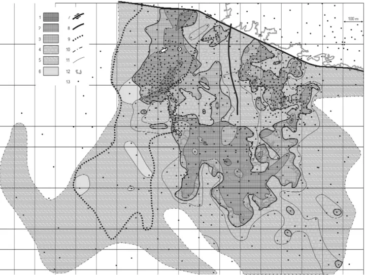
Petrographic composition of the bauxite sequence and its structure
In the former years mainly the bauxite sensu stric- to was studied by the different authors. The author of this monography tried to evaluate all rock types of the bauxite sequence and to understand their relation- ships. The following rock types were distinguished by him in the Halimba deposit:
1. Bauxite sensu stricto — SiO2 content less than 9.9%, Al2O3 more than 46%, carbonate minerals less than 10%.
2. Clayey bauxite — SiO2content 10–19.9%.
3. Bauxitic clay — SiO2content more than 20%.
4. Red, kaolinitic clay — Al2O3/SiO2 less than 0.85, does not contain bauxite minerals.
5. Bauxite and clayey bauxite containing 10% to 50%
limestone and dolomite debris.
6. Limestone and dolomite conglomerate — carbonate content more than 50%.
7. Limestone and dolomite siltstone (aleurolite)— grain size less than 2 mm, carbonate content more than 50%.
8. Bauxite and clayey bauxite — containing more than 10% secondary calcite
9. Grey pyritic-marcasitic bauxite, clayey bauxite and bauxitic clay — S content more than 0.6%.
The rock types listed above form in the bauxite sequence independent layers. Symmetric frequency distribution of their main chemical components is a confirmation of their separate existence. The areal dis- tribution of the rock types is illustrated on Figure 13.
Separate signs indicate the contours of the bauxite bod- ies. They are extremely sinuous, deep embayments and long narrow bulges occur quite frequently. Separate studies of the author revealed that they correspond to shallow channels, filled by bauxite or clayey bauxite.
In the southern part of the deposit, on the western and eastern side of the bauxite bodies the entire baux- ite sequence consists of bauxitic clay. On the western rim it alternates with detritic carbonate rocks layers.
The extent of the bauxitic clay is largest and in most places it furnishes the contour of the deposit. In the southern edge of the deposit layers of red kaolinitic clay occur between the clayey bauxite layers.
A stripe of bauxitic clay and clayey bauxite was located by the boreholes in the central part of the deposit, starting from the WNW/ESE striking main fault line and ending in the Cseres bauxite body. It is about 400 m long and 50 m to 100 m wide, separating the main bauxite bodies in the west and the east (Figure 13). It is interpreted by us as a flat hill, where no bauxite could be sedimented. An older fault line follows this zone in north/south direction.
The large western bauxite body is flanked directly by bauxitic clay, whereas in all other cases clayey bauxite occurs around the bauxite bodies. Bauxitic clay and clayey bauxite occur also in the area of the bauxite bodies, below and above the bauxite layers.
Table 3.Number of layers in the boreholes in the sectors of the southern part of the Halimba deposit
Within the bauxite itself a high-grade (SiO2less than 4%) and medium-grade (SiO2 4% to 9.9%) bauxite type can be distinguished. They are spatially separated. The high-grade type is mainly limited to the central, channel-bed facies of accumulation in the western and the Cseres bauxite body (Figure 13). It forms in the large eastern bauxite body a very irregular stripe of sinuous contours. The medium-grade bauxite occurs on both sides of the high-grade one and it is interpreted by us as levee (channel-rim) sediment. The high-grade bauxite is concentrated in the thickest parts of the bauxite layer. Only small packages of high-grade bauxite were found outside these thick layers. These features are valid also for the northern part of the deposit.
Based on these observations the author of the monography tried a quantitative evaluation of the above out- lined features. He divided the nine, above described petrographic types into three genetic groups as follows:
— Rock types derived from the sedimentary accumulation of lateritic weathering products: bauxite, clayey bauxite, bauxitic clay and red kaolinitic clay.
— Rocks consisting of detritic material of carbonate rocks: limestone and dolomite conglomerate, siltstone and their transition into bauxitic rocks
— Rock types of secondary origin: bauxite containing secondary calcite, grey pyrite and marcasite contain- ing bauxite
The thickness of the rock types was determined in all boreholes and recalculated into percentages (Table 4). The sector No.13 was excluded from the table, as in most of its boreholes the total thickness of the bauxite sequence is unknown. The table shows a rather regular pattern. The proportion of the laterite derived rock types reaches 95–99% in the eastern part of the deposit, as shown on Figure 14. It diminishes to 84–95% in the Cseres bauxite body and in the central part of the deposit. A further decrease was found in the western baux- ite body from 57%, down to 35%.
The proportion of the bauxite sensu stricto within this first group shows also a characteristic areal pattern (Figure 14). It is smallest in the eastern part of the Cseres bauxite body (23%) and it grows gradually to 45%
in its western part. It reaches 36% in the northern part of the western bauxite body and 38% in its central part despite the fact that the total proportion of the lateritic group strongly decreased in this bauxite body. This seems to be a regular areal trend, confirmed by the large number of the evaluated boreholes.
Some years ago, when evaluating the deposits of the Szõc bauxite occurrence I found an areal segregation of the bauxite, clayey bauxite and bauxitic clay. It could be explained by the fluvial transportation and accu- mulation of the lateritic weathering products. The clayey material transported in the form of colloidal solu- tions accumulated mainly in the farther parts of the occurrence, under more quiet facies conditions. On the other hand, the harder, more detritic bauxitic material accumulated preferably in areas of channel-bed facies.
The clayey bauxite accumulated as a transition between these two areas. A similar areal pattern can be seen on Figure 13 for the Halimba bauxite deposit.
If only the proportion of the clayey bauxite and the bauxitic clay is evaluated than a SE/NW directed belt, enriched with bauxitic clay can be distinguished. The proportion of bauxitic clay gradually decreases from the southeast to the northwest: 52–46%, 40–24%, 10%. This can be seen on Figure 14. On both sides of this belt the proportion of bauxitic clay is smaller. This pattern is interpreted by us as a characteristic fluvial facies pattern.
Table 4.Proportion of rock-types in the sectors of the southern part of the Halimba deposit
It has been already mentioned before, that layers of red kaolinitic clay occur in the south-western rim of the deposit, thus the role of the red kaolinitic clay was very limited in the Halimba bauxite deposit. Let us stress that kaolinitic clay occurs in the lower part of most lateritic bauxite deposits. Thus the presence of kaolinitic clay layers in the Halimba bauxite deposit cannot be considered as an exceptional feature.
The second large group of rocks — distinguished above — is that of the detritic carbonate rocks. They are called the “Cseres Member of the Halimba Bauxite Formation” and are considered as an independent lithos- tratigraphic unit. It consists of rock debris of different size, ranging from one millimetre up to 30 cm. The grain size diminishes from the south to the north. They are angular or slightly rounded and are cemented by baux- ite, clayey bauxite or bauxitic clay. An important feature of this group is that the debris consists exclusively of carbonate rocks, mainly limestone and dolomite of Mesozoic age. No quartz or silicate rocks were found so far. The proportion of the cementing material diminishes downward.
The areal distribution of this group is very characteristic, as seen on Figure 15. The rocks of this group do not occur in the eastern rim of the Cseres bauxite body. They represent only 1% in the neighbouring levee sec- tor. They reach 9% in the central channel-bed sector and finally reach 11% in the western rim of this bauxite body. They form generally thin layers in the lower part of the bauxite sequence.
A similar pattern is found when going to the north: In the sector of the eastern rim (sector No. 6) only 0.5%
of the bauxite sequence consists of this rock group. The large eastern bauxite body contains 3% of them. 12% is reached in the central part of the area. Finally, in the western bauxite body an abrupt increase can be observed:
First 12.5% in its eastern sector, followed by 39% in the northern sector. The central sector contains 45%. The amount in the western sector can be only estimated to 60% or even more. The thickness of the individual detrit- ic carbonate rock layers varies from half metre to more than 10 m and it may change significantly within a short distance.
The distribution of the detritic carbonate rocks was considered before to be completely irregular. BÁRDOSSY et al. (1998a, b) first found that these rocks preferably filled the western valley. This areal filling changed grad-
Figure 14.Percentage of the bauxitic rock types within the bauxite sequence in the southern part of the Halimba deposit 1 — Bauxite %, 2 — clayey bauxite %, 3 — bauxitic clay %, 4 — contour of the bauxite sequence, 5 — contours os the sectors, 6 — exca- vated bauxite
14. ábra.A bauxitos kõzetek vastagságának százalékaránya a bauxitösszletben a halimbai elõfordulás déli részén
1 — bauxit %, 2 — agyagos bauxit %, 3 — bauxitos agyag %, 4 — a bauxitösszlet határa, 5 — a részterületek határai, 6 — kitermelt bauxit
ually to the north into sinuous stripes of some tenths of metres width (Figure 13). They are considered as creeks cut into the bauxite sequence. Finally, in the north only isolated spots of detritic carbonate rock layers occur. This pattern was confirmed by the later mining activities.
There is an important trend within the distribution of this group of rocks: conglobreccia being dominant in the south-western sectors of the deposit, and its proportion diminishing in north-eastern direction (Figure 15). It is gradually replaced by carbonate aleurolite and by the transitional bauxitic and detritic carbonate rocks. This again confirms our assumption that the detritic carbonate material was transported to the Halimba Basin from the south-west, from a relatively short distance.
Chemical analyses were carried out for many detritic carbonate rock samples of the boreholes. They fur- nished important information that will be discussed in the chapter: The main and accessory chemical compo- nents of the Halimba deposit.
The proportion of the detrital carbonate rocks is very variable in the bauxite sequence of the deposit. For this reason a special evaluation was carried out recalculating the total amount of the lateritic group to 100%. The results of this evaluation are presented on Figure 16. The belt of bauxitic clay separating the western and the eastern bauxite bodies became clearly visible by this evaluation. The proportion of bauxitic clay is highest in the south-east (53%) and it diminishes gradually to 48%, 43%, 35% and finally to 12%. In the same time an increase of the clayey bauxite can be observed from 24% to 32%, 36% and finally to 58% (Figure 16). It is interpreted as a process of segregation occurring during the accumulation of the bauxite sequence.
As mentioned above, the third group consists of secondarily altered bauxite and clayey bauxite. Their propor- tion within the bauxite sequence is shown in Table 4. The bauxite containing secondary precipitations of calcite is most frequent in the eastern bauxite body (sector No.7) where it reaches 1.9%. It was detected only in four other sectors in even smaller amount. It occurs always on the top of the bauxite layer and quickly diminishes down-
Figure 15. Percentage of detritic carbonate rocks within the bauxite sequence in the southern part of the Halimba deposit 1 — percentage 10–30, 2 — percentage 30–60, 3 — percentage more than 60, 4 — bauxite containing dolomite and limestone debris, 5 — conglobreccia, 6 — aleurolite consisting of dolomite and limestone debris, 7 — contour of the bauxite sequence, 8 — contours of the sec- tors, 9 — excavated bauxite
15. ábra.A karbonáttörmelékes kõzetek vastagságának százalékaránya a bauxit összletben a halimbai elõfordulás déli részén 1 — 10–30%, 2 — 30–60%, 3 — 60%-nál nagyobb, 4 — dolomit- és mészkõtörmelékes bauxit, 5 — konglobreccsa, 6 — dolomit- és mészkõaleurolit, 7 — a bauxitösszlet határa, 8 — a részterületek határai, 9 — kitermelt bauxit
ward. Its thickness is generally less than 2 m. There is only one borehole (Halimba H–2494) where its thickness reached 3.4 m. At places where two or more bauxite layers were detected, only the upper one contains these sec- ondary precipitations. There are several boreholes where secondary calcitic bauxite was observed in the bauxite, but its amount did not reach the 10% cut-off value. They were not included into the above listed averages.
The grey pyritic-marcasitic bauxite is much more frequent than the calcitic one. It occurs on the top of the baux- ite sequence where the immediate cover is marshy clay of Middle Eocene age. A reducing process transformed the originally red bauxite into the grey one. As shown on Table 4, this secondary rock-type is present in all sectors of the southern part of the deposit. Its proportion is generally 1% to 8%, but it reaches 18.2% in the south-west- ern edge of the deposit (sector No. 28). Its thickness varies mostly from 0.5 m to 3 m. Its maximum thickness was found in borehole Halimba H–2512 with 7.9 m. No pyritic-marcasitic bauxite occurs below the Senonian cover.
Grey pyritic-marcasitic bauxite was found in 9 boreholes on the bottom of the bauxite sequence in the north-western side of the western bauxite body (sector No. 14). Its average thickness is 4.7 m, with a maxi- mum value of 14.4 m in the borehole Halimba H–2233. It forms a strip, elongated in north-east/south-west direction, following the down faulted side of an ancient fault line that existed already when the bauxite accu- mulated in the Halimba Basin. It was met recently also in a gallery of the mine to the south-west of the above mentioned strip. This peculiar occurrence of the pyritic-marcasitic bauxite is interpreted by us as the product of a secondary, reducing process. Marshy conditions developed on the down faulted side of the fault line lead- ing to the reduction of the originally normal, red bauxite. There is no indication that the grey bauxite was formed directly during the accumulation of the deposit.
Special investigation was carried out by the author to detect any regularity in the sequence of the differ- ent layers of the deposit. The method of Markov-chains was applied for this evaluation. Let us remind that those sedimentary processes are called Markov-chains, where the presence or absence of a feature in a layer depends partially from the preceding layer and partially from not detected stochastic processes.
Figure 16. Percentage of the thickness of the three bauxitic rock types in the southern part of the Halimba deposit.
1 — bauxite in %, 2 — clayey bauxite in %, 3 — bauxitic clay in %, 4 — contour of the bauxite sequence, 5 — contours of the sectors, 6 — excavated bauxite, 7 — bauxitic clay 100%, 8 — the highest percentage of bauxitic clay within the bauxite bodies
16. ábra.A három bauxitos kõzetfajta vastagságának százalékos aránya a halimbai elõfordulás déli részén
1 — bauxit aránya %-ban, 2 — agyagos bauxit aránya %-ban, 3 — bauxitos agyag aránya%-ban, 4 — a bauxitösszlet határa, 5 — a részterületek határa, 6 — kitermelt bauxit, 7 — bauxitos agyag 100%, 8 — a legnagyobb bauxitos agyag arány a bauxittesteken belül
For the evaluation the bauxite sequence was divided from the bottom to the top into intervals of one meter thickness. ”Transition frequency matrices” and “transition probability matrices” were calculated according to the method described in the book of DAVIS(1986). Eight profiles were selected, containing 70 boreholes. They were directed in south-east/ north-west direction following the assumed direction of bauxite accumulation.
The main results of these evaluations are as follows: The succession of the layers is very similar in all sec- tors of the deposit. Only the south-western part of the deposit has particular sedimentologic features because of the arrival of the detritic carbonate material. It is a general trend that in this part of the deposit bauxite lay- ers directly overlay the layers of the detritic carbonate rocks. On the other hand, in the eastern and northern part of the deposit bauxitic clay is generally followed by clayey bauxite and finally by bauxite. Characteristic is the quick variation of different detritic carbonate rock layers in the western part of the deposit. This feature indicates an intense, highly variable process of accumulation of these rock types. The results of these investi- gations were applied to the genetic evaluation of the deposit, discussed in chapter: The origin of the Halimba bauxite.
The structure and texture of the Halimba bauxite was studied by several authors. A detailed macroscopic and microscopic study was carried out by MINDSZENTY(1983, 1984). She distinguished primary, early diagenet- ic and late diagenetic processes producing different textural elements in the bauxite. Based on these studies she distinguished bauxites of “vadose” facies, accumulated at higher places, and “saturated” bauxites, accu- mulated close to the groundwater level — at lower places. The bauxites of the Malom Valley occurrence are of vadose facies, those of the Halimba Basin of saturated facies.
JUHÁSZ(1988) carried out detailed macroscopic and microscopic investigations on borehole samples of the Halimba deposit. She found that the grain size of the textural elements increases from the bottom to the top of the deposit. She distinguished a set of local facies types within a fluvial environment: channel bar, channel load, flood plain, flood basin and marshy facies types. These facies types occur in the form of layers, being in good agreement with the author’s former assumptions. The most frequent types of structures are micro and macro detritic. Rarely bauxite-conglomerate also occurs. Detritic “roundgrains” are also frequent — not to be confounded with ooids and pisoids of diagenetic origin. Pelitomorphic structures are relatively rare. Similar results were obtained by BÁRDOSSYet al. (2000). The new mining operations in the Halimba II mine allowed new detailed observations in the galleries confirming our former findings. It can be concluded that the Halimba bauxite types are mainly of detritic texture with quickly varying grain sizes.
BÁRDOSSYet al. (1978) studied the Halimba bauxite by scanning electron microscope. They found that the grain-size of the bauxite is generally between 0.1 µm and 0.3 µm. The secondary minerals, e.g. pyrite, calcite have a much larger grain size. They observed that the “space filling” of the bauxite is the same in the shallow parts of the deposit and in the deeper ones, with a cover reaching 300 m.
The colour of the bauxiteis mainly brick-red, with white spots and veins in its upper part. Violet bauxite occurs only on the top of the bauxite bodies. As mentioned before, grey bauxite occurs mainly on the top of the deposit and on one place only over the footwall surface. The clayey bauxite and the bauxitic clay are also brick-red, but generally more light coloured.
The bauxite is generally medium hard, rarely hard with conchoidal fracture. The detritic carbonate rock types are harder than the bauxite. On the other hand, the clayey bauxite and the bauxitic clay are less hard than the bauxite and they have an earthy fracture.
In 1990 in the Halimba III mine grey marl, clayey marl and lignitic clay was found below high-grade baux- ite. The marl contained bauxite pebbles. It was 2 m to 4 m thick, directly underlain by Triassic Dachstein Limestone. Micropalaeontologic study of this layer found fossils of Albian age. It is considered by GÓCZÁNet al. (2002) that it belongs to the Albian Tés Clay Formation. The genetic significance of this important finding is discussed in the genetic chapter (The origin of the Halimba bauxite).
The main and accessory chemical components of the Halimba deposit
During the exploration systematic sampling was carried out from the bauxite sequence in each borehole.
The sampling intervals were 0.5 m and 1.0 m. In the case of special bauxite types, e.g. grey pyritic bauxite, the sampling intervals were diminished to 0.1–0.5 m. The samples were analysed for the main chemical compo- nents. Until the end of the nineties the entire bauxite deposit was analysed, including the detritic carbonate rock layers. After that time — for economic reasons — these rock samples were excluded from the chemical analyses. Considerable economy was achieved this way, but in the same time important geochemical informa- tion, were lost.
The bauxite samples were analysed for Al2O3, SiO2, Fe2O3and TiO2and ignition loss by traditional wet ana- lytical methods. Since 2004 only the Al2O3 and SiO2 contents are analysed by neutron activation.
Determination of CaO, MgO, CO2, S, P2O5and MnO2occurred on selected samples, and not over the entire
deposit. Finally a limited number of “composit samples” was prepared from a number of single samples for the determination of their technological properties.
Copies of all available analytical documents were collected by the author and a computerized data base was established with the technical help of the Hungarian Academy of Sciences. More than 20 000 records were fixed in this data base, containing more than 350 000 numerical data. The statistical evaluation of these data occurred on a Windows XP computer. To check the validity of the analyses the sum of the components was computed for each record. Only sums being between 95.0–101.0% were accepted for the statistical evaluation.
In all other cases the source of the error was searched. This way the results could be corrected in many cases.
The remaining records were excluded from further evaluations.
The author published in 1961 a monography on the geochemistry of Hungarian bauxites. The Cseres and Tormás-kút (sector No. 15) bauxite bodies of the Halimba deposit were included in this evaluation. The eval- uation was limited to the entire bauxite sequence that is the layers of different composition — discussed in the foregoing chapter — were not evaluated separately. This approach can be considered as a general overview of the deposits. In the present monography all rock types of the deposit were evaluated separately, allowing a more detailed understanding of the deposit.
JOCHÁNÉEDELÉNYI(1981) was the first to evaluate the entire Halimba deposit for Al2O3, SiO2, Fe2O3 and TiO2. This evaluation did not distinguish the different rock types of the deposit. MÁTÉFI(2002) performed a similar geochemical evaluation for the northern rim of the Halimba deposit, again for the entire bauxite sequence. He published also a number of histograms of the main chemical components. Both publications contained important information about the geochemistry of the deposit.
BÁRDOSSYet al. published in 2000 new geochemical evaluations on the Halimba deposit. Since that time a large number of chemical analyses were carried out in the southern part of the deposit for the preparation of the new mine. This allowed me to investigate in more detail the geochemistry of the southern area. Special attention was paid to the scaling-effect.
The first step of the geochemical evaluation was the calculation of the weighted averages of the bauxite layers in all productive boreholes. These are 530 in the southern 320 in the northern part of the deposit. The bauxite, clayey bauxite and bauxitic clay layers were calculated separately. The second step was the calcula-
Table 5.Weighted averages of the main chemical components of the Halimba bauxite
* Tukey’s estimator, n.m.= not analysed