University of Sopron
Thesis of (PhD) dissertation
INVESTIGATION OF MODERN INSTRUMENTS AND MEASUREMENTS METHODS IN FORESTRY MAPPING
Tamás Bazsó
Sopron
2017
Roth Gyula Doctoral School of Forestry and Wildlife Managemant Sciences Forest Assets Management Course
Supervisor: Associate professor Dr. Kornél Czimber
Aims and scope
In the past century, forest survey and mapping were carried out with traditional geodetic instruments, of which the Wild T0 compass theodolite is by far the most important one. By the end of the century, the use of aerial photographs became increasingly important, and analogue geodetic instruments were replaced by electronic total station which are not widely used in forestry. Today, satellite (GNSS) surveys and orthophoto based mapping feature forestry applications. To increase mapping accuracy, it would be important to use an easy-to-use electronic instrument with traditional geodetic principles.
Over the last few decades, there have been many solutions to making geodetic measurements simpler and more cost-effective. These instruments are handheld laser rangefinders that are capable of determining angles (both horizontal and vertical). Though improvements in many cases specifically targeted the forestry application, in Hungary this new category of instruments is not really known and used.
The aim of the dissertation is to determine the accuracy and practicality of the use of these handheld laser rangefinders in forestry practice. The primary instrument of the test is the most well-known TruPulse 360B (Lasertechnology) in Hungary, with which you can measure distance, vertical angle and magnetic azimuth (horizontal angle). Since the measurement volumes and the accuracy of the instrument are similar to the Wild T0 compass theodolite, it can provide a perfect solution to mapping based on the technical features of the instrument. The instrument does not yet have adequate references, so the dissertation also addresses the impact of the environmental factors on the field measurements beyond the accuracy of the measurement volumes. Examination of the applicability of the instrument means both the testing of the measurement technique and the comparison of the measurement technique with other measurement methods. The comparison is based on the measurements of the Wild T0 compass theodolite and geoinformatical GNSS instruments (accuracy ~1m) and also the mapping accuracy provided by orthophotos.
The dissertation relies on the results of nearly 2000 measurements for the evaluation of the instrument, half of which includes the impact of the field conditions on the measurement results. The author examines the measurement attributes of a rangefinder using different horizontal measurement principles (encoder – direction), the Disto S910 (Leica) for comparison purposes.
The methodology of the research
The methodology of the research is in line with the examination of a surveying instrument, but it also deals with the impact of field conditions on the measurement results apart from the determination of the instruments’
measurement accuracy.
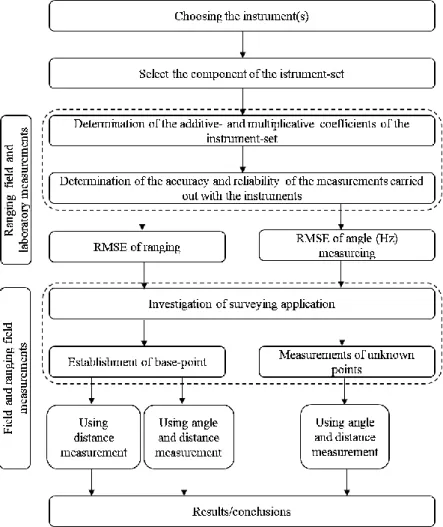
Figure 1: Methodology of the examination.
The methodological steps of the dissertation can be followed in Fig. 1. The details and the results of the tests carried out along with the methodology steps are described under the following three main headings: Calibration measurements (precision tests), Examination of base point determination methods (field applications) and Observation of measurements in field conditions
1. Calibration measurements
The calibration was based on a set of measurements, which can be used to determine the relationship between the measured values and the reference value. The measurements were carried out, in laboratory condition and baselines. The primary task was to determine the accuracy of the measuring attributes - distance and horizontal angle – described in the instrument specification documentation, and also the examination of the impacts of the forest environment was part of the calibration measurements.
2. Investigation the establishment of base-point
Field measurements of mapping require more point in the base point network.
The determination of the base point requires more accurate measurement than the measurement of the unknown points, hence the tests had to be aligned accordingly. Among the baseline determination methods, the compass- traversing method was the basis of the study which is the most commonly used method for forest mapping, but the thesis focuses also on the ranging- based triangulation, which is more closely aligned with the measurement accuracy of the instruments.
3. Investigation the field measurements
The practical applicability of the tests can be determined by measurements carried out in field conditions. The impact of field conditions were investigated based on the measurement results of three typical mapping tasks.
To characterize stock surveys within the boundaries of the forest, a sample surveys and a full-scale survey at tree level were performed. The third mapping area was a green urban area, the measurement conditions of which were similar to those in the forest.
Results
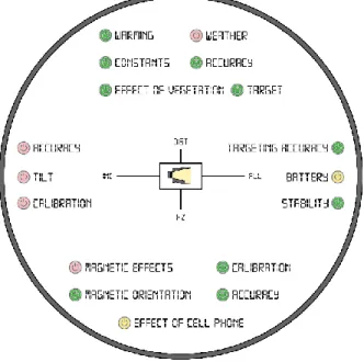
The analysis of the measurements from TruPulse 360B revealed additional impacts on its accuracy, which encouraged further investigations. These impacts are depicted in figure 2, where they are organized in three groups (dist - range, inc - inclination, HZ – azimuth, all – all together) according to their influence on the measured quantities. Present thesis focuses on a subset of impacts as it is indicated in figure 2 with colour codes (green – investigated, red – out of scope, yellow – requires further research).
Figure 2: Factors influencing the accuracy of TruPulse.
1. Results of ranging
Calibration measurements provided the additive- and multiplicative coefficients, as well as the RMSE and mean random error, which are regarded to as metrics of the accuracy and reliability of the instrument.
Both investigated instruments comply with the accuracy parameters published in the product specification. The accuracy of instrument TruPulse
overperformed the nominal data providing RMSE of ±0.06 m and mean random error of ±0.06 m with the use of reflector and noise filtering optics.
2. Results of angular measurements
Investigations in association with angular measurements addressed not only the accuracy of sensors but they implied the deviations that encounter resulting from the operational use of the instrument. Taking these considerations into account, the accuracy of the instruments does not meet the parameters of system performance listed in the product specification.
The measurements were qualified by means of RMSE and mean random error as before. Due to the magnetic-based angular measurement principle used in TruPulse, some additional error sources have emerged. The RMSE of TruPulse is ±2.38°, while the RMSE of instrument Disto is ±2.38°.
3. Results of the establishment of base-point
With evaluation of traverses, TruPulse has provided similar accuracy to that of compass theodolite Wild T0. The highest accuracy was achieved by using rapid compass-traversing method with a maximum error of 1.5 m along a traverse of 400 m. Since instrument Disto does not display the results of angular measurements, processing of traverses is impossible.
Ranging-based triangulation resulted higher accuracy for base-point measurements in accordance with the higher ranging accuracy of the instruments.
4. Results of field measurements
Due to the impacts of forested environment and of the objects to be measured (i.e. trees) the point positioning error has increased; although the instruments still performed better in comparison to other mapping techniques.
Identification of individual trees was successful at the achieved level of accuracy.
Conclusions
Based on the investigation of instruments and measurement methods, TruPulse 360B and Disto S910 meet the accuracy requirements of forest mapping. Instruments with different measuring principles show better results in their different properties.
The author presented the conceptual design of a survey instrument and the basis of a method for mapping forests and urban green areas based on the weaknesses and strengths of the TruPulse 360B and Leica Disto S910 devices that represent the two main branches of easy-to-use electronic survey tools.
Specifications of the ideal survey tool:
Distance measurement:
• method: laser rangefinder
• measuring distance: at least 50m (70m)
• accuracy: ±1cm
• distance measurement with (filtered signal) or without a target prism
Angle measurement:
• compass sensor that can be deactivated
• encoder for measurements with oriented angle
• accuracy: ±0,1°
• inclinometer accuracy: ±0,1°
Design considerations:
• adjustable focus telescope with mechanical cross-hair
• usable with tri- or monopod
• one day battery life
• Bluetooth
Survey method:
• accessible raw measurement data for postprocessing
• angle measurement with encoder after magnetic bearing determination
• distance measurement by prism target and noise reduction
• use of monopod and support
• data connection with a GIS capable device that displays the measured points
• estabilihment of base point from GNSS, traversing or intersection with distances
Thesis
I. I have confirmed that the ranging accuracy of TruPulse 360B meets the accuracy declared by its manufacturer Laser Technology in ideal external conditions (ranging field). I revealed the need of using reflector and noise filtering adapter for ranging in forested environment, otherwise gross errors (error exceeding the measurement accuracy) might encounter. I propose to carry out minimum of two measurements for each ranging when reflector-less mode is applied. In case the measurements are consistent within the accuracy of the instrument (L1 – L2 ≤ 0.3 m), the ranging result can be accepted, so the bias from foliage and twigs is eliminated.
II. I specified the magnetic-azimuth-measurement accuracy of Laser Technology TruPulse 360B as ±2.38°. Accepting the accuracy of ±1°
declared in the instrument’s specification, further error sources in horizontal angle measurements are assumed. These errors arise from the inaccuracy of the sighting optics (< 0.5°) and in greater part from the inadequate calibration of the digital compass. The reliability of the real- time azimuth measurement is insufficient, so it would be advantageous to enable measurement of (non-magnetic) azimuths following the arrest of the magnetic north direction – as is the case of instrument Wild T0.
As result of test measurements, I concluded that the instrument ensures adequate accuracy (ranging error below 0.3 m up to range of 20 m) for forestry applications (surveying of compartment boundaries, locating forest inventory plots, creating base maps for civil engineering), providing the measurements are performed from base points of geodetic accuracy.
III. I have proven with in-situ experimental measurements that base points should be measured with ranging-based triangulation when using TruPulse 360B from Laser Technology in forest or green urban area because the accuracy in ranging (<0.3 m) is superior to that of azimuth measurement. The use of rapid compass-traversing method is proposed for surveying projects with sub-meter accuracy requirement.
IV. I revealed upon field measurements that the encoder-based angle measurement of Leica Disto S910 allows higher point measurement accuracy compared to TruPulse 360B that measures magnetic azimuth.
As the digital compass is oriented to the magnetic north direction, it should be arrested and the locating of further points should be done relative to this direction by means of non-magnetic azimuth measurements.
V. Following the accuracy assessment of various ranging and angular measuring methods as well as carrying out high number (approximately 2000) of in-situ measurements, I propose an instrument construction that is cost-efficient, convenient to use and allows surveying for forestry purposes and mapping of infrastructure.
The instrument must contain a laser-ranging unit with accuracy of ±1cm and effective range of minimum 50 m allowing measurement in both reflector and reflector-less mode. Regarding horizontal angle measurement, it is crucial to include both encoder and magnetic sensor with angular accuracy minimum of 0.1°. Likewise, the inclination sensor should have angular accuracy minimum of 0.1°. The construction must be lightweight, convenient to use with adjustable focus and precise cross-hair. It is essential to enable the mounting of the instrument onto light platform (rod or bipod) and ensure power supply for over a labour day. Bluetooth module and standard data stream is required for controlling the instrument from external device (smart phone) in real- time mode.
Publications (in the subject of the dissertation)
MSc Theses
BAZSÓ T. (2007): A Hidegvíz-völgy Erdőrezervátum kutatási eredményeinek térinformatikai feldolgozása.
BMGE, Építőmérnöki Kar, 56 p.
Lecture notes
BAZSÓ T. (2009): Térképismeret. Lecture note.
Sopron, 58 p.
Books and chapters in book
BAZSÓ T. – PRIMUSZ P. (2014): Simple Geospatial Data Collecting Methods for Environment Change. In: Santamarta JC, Hernández-Gutiérrez LE, Arraiza MP (ed.) Natural Hazards & Climate Change: Riesgos Naturales y Cambio Climático. Madrid: Colegio de Ingenieros de Montes/Forestry Engineers Association, pp. 189-198.
POLGÁR A.–PÉCSINGER J.– PINTÉRNÉ N.E.–ELEKNÉ F.V.–RUMPF J.
–SZAKÁLOSNÉ M.K.–HORVÁTH A.L–BAZSÓ T. (2014): Forestry and Field Plant Production Technologies in Environmental Life-Cycle Thinking. In:
Santamarta JC, Hernández-Gutiérrez LE, Arraiza MP (ed.) Natural Hazards
& Climate Change: Riesgos Naturales y Cambio Climático. Madrid: Colegio de Ingenieros de Montes/Forestry Engineers Association, pp. 155-174.
Peer-reviwed journal articles
BAZSÓ T. – SAJTOS M. (accepted): Map preparation with Leica Disto S910 instrument at Paprét, Sopron.Leica Geosystems news
MOLNÁR D – BARTON I. – CZIMBER K. – BAZSÓ T. – FRANK N. (2016):
Faállomány-szerkezeti kutatások a Roth emlékerdőben. Erdészettudományi Közlemények. 6/2. pp.127-136.
BAZSÓ T. – PRIMUSZ P. – NÉMETH M. (2014): A TruPulse lézeres távolságmérő alkalmazhatósága erdészeti térképezési feladatokra.
Erdészettudományi Közlemények. 4/1. pp.147-158.
BAZSÓ T. (2014): Távérzékelés alkalmazása a mezőgazdaságban.
Geomatikai Közlemények. 17. pp. 79-92.
BAZSÓ T. (2007): Integrált geodéziai műszer-együttes alkalmazásának vizsgálata erdőrezervátumok területén. Geomatikai Közlemények. 10. pp.
281-286.
Proceedings and abstracts
BAZSÓ T. (submitted): A TruPulse 360 B tesztelése. In: Bidló A, Facskó F (ed.) V. Kari Tudományos Konferencia - Nyugat-magyarországi Egyetem Erdőmérnöki Kar: a konferencia előadásainak és posztereinek kivonatai. 42 p. 2015.10.21 Sopron, Hungary, Nyugat-magyarországi Egyetem Kiadó, pp. 21-22.
BAZSÓ T. – PRIMUSZ P. (2017): Application of laser rangefinders in forestry surveys. In: Stelian Alexandru Borz, Marina Viorela Marcu (ed.) Proceedings of FORMEC 2017: 50th anniversary of the International Symposium on Forestry Mechanization. 294 p. 2017.09.25-2017.09.29.
Brassó, Romania, Transilvania University of Brasov, 2017. p. 32. 1 p.
BERTALAN L. – BAZSÓ T. (2016): Domestic gardens of the City:
Problems of Peri-Urban Land Use in Sopron, Hungary. In: Ladislav Mura, Monika Bumbalová, Monika Gubáňová (ed.) SUSTAINABILITY OF RURAL AREAS IN PRACTICE: Conference Proceedings from International Scientific Conference. 566 p. Nitra, Slovakia, 2015.12.03-2015.12.04., pp. 470-479.
BAZSÓ T. – PRIMUSZ P. (2015): A TruPulse 360 B pontossági vizsgálata térképezési feladatokhoz. In: Bidló A, Facskó F (ed.) V. Kari Tudományos Konferencia - Nyugat-magyarországi Egyetem Erdőmérnöki Kar: a konferencia előadásainak és posztereinek kivonatai. 42 p.
Sopron, Hungary, 2015.10.21., pp. 21-22.
MOLNÁR D. –BAZSÓ T. – CZIMBER K. – FRANK N. – HORVÁTH T. – FÁBIÁN F. (2014): Vegyeskorú erdőben végzett teljes faállomány-felvétel Field-Map rendszer alkalmazásával. In: Bidló A., Horváth A., Szűcs P. (ed.) IV. Kari Tudományos Konferencia: Konferencia kiadvány. 407 p.
Sopron, Hungary, 2013.12.10., pp. 387-388.
BAZSÓ T. – KIRÁLY G. – MÁRKUS I. (2013): Changes of the enviromental conditions at Lake Fertő. In: Santamarta-Cerezal J C, Hernández Gutiérrez L E (ed.) Environmental Security, Geological Hazards and Management: Proceedings. 230 p. Tenerife, Spain, Universidad de La Laguna. 2013.04.10-2013.04.12., pp. 137-145.
BAZSÓ T. – KIRÁLY G. – MÁRKUS I. (2013): New surveying methods of Lake Fertő, Hungary. In: Péter Kalicz, Zoltán Gribovszki, Kamila Hlavcová, Silvia Kohnová (ed.) HydroCarpath International Conference Catchment Processes in Regional Hydrology: Experiments, Modeling and Predictions in Carpathian Drainage Basins. Sopron, Hungary, 2013.10.27-2013.10.28., Paper 1.
PUSKÁS L. – SZÉP K. – BAZSÓ T. (2011): Magyarországi fakataszterek.
In: Puskás Lajos (ed.) Magyar Faápolók Egyesületének a konferenciája:
Proceedings. Budapest, Hungary, 2011.04.29., pp. 23-29.
BAZSÓ T. – EREDICS A. – KIRÁLY G. (2007): Digitális amatőr kamerák kalibrációja és a kalibrált kamerák felhasználási lehetőségei. In: Lakatos F, Varga D (ed.) Erdészeti, Környezettudományi, Természetvédelmi és Vadgazdálkodási Tudományos Konferencia (EKTV-TK). 189 p.
Sopron, Hungary, 2007.12.11., p. 26.