University of Sopron Faculty of Forestry
EFFECT OF ROBINIA PSEUDOACACIA, POPULUS X.
EURAMERICANA AND QUERCUS ROBUR PLANTATIONS ON GROUNDWATER AT THE NORTHERN HUNGARIAN
PLAIN
Thesis of PhD dissertation Szabó András
Sopron -2019-
Roth Gyula Doctoral School of Forestry and Wildlife Management Sciences
Program: Ecology and diversity of forest ecosystems (E1) Supervisors: Dr. Gribovszki Zoltán, Dr. Tóth Tibor
Introduction
Although the role of forests in the water balance has been the subject of investigation practically since the dawn of science, it is still a disputed question. This apparent contradiction is indicative of both the social importance and the complexity of water–forest systems.
Due to the numerous indirect effects of this question, it is considered important at many levels of society. As the role of water as a resource is likely to become increasingly significant in the future, even more interest will be generated. A good example of this is the Alföld region, where declining groundwater levels over the last few decades mean that the role of forest stands in water management is by no means an internal matter affecting only the forestry sector, but is the subject of repeated debates involving other sectors, such as agriculture and nature conservation. Since it is predicted that the groundwater level will continue to drop, conflicts of interest between different sectors could flare up to an even greater extent. This debate is indirectly related to questions of land use.
Despite years of research, there is still no consensus on the role of forests in reducing the groundwater. This can be attributed primarily to the complexity of the (ground)water–forest system, which involves numerous factors that vary greatly over space and time and in some cases are extremely difficult to measure directly (e.g. the depth of the root system of forest stands, the horizontal flow of groundwater below the soil surface).
Based on the above, the aim of the present research was to investigate the basic hypothesis given below, taking into consideration the factors influencing it, with special regard to soil science factors.
According to the basic hypothesis, the increased water uptake caused by forest plantation causes changes in the hydrological cycle of the given area, resulting in a lower groundwater level under the forests.
This also exerts an effect on the movement of salts dissolved in the groundwater, which become more concentrated in the root zone, due to the selective ion uptake of the plants. The accumulation process is proportional to the water uptake of the vegetation, i.e. compared to control points covered by herbaceous plants, relatively greater salt
accumulation can be recorded at a lower depth under woody plants due to their greater water uptake and deeper root zone.
1. Materials and Methods
1.1. Criteria for the choice of sample areas
In line with the aims of OTKA project No. NN 79835, the sampling areas were selected with the help of a category matrix. The parameters and categories in the matrix were as follows:
– the tree species examined (Quercus robur L., Robinia pseudoacacia L., Populus x euramericana)
– the age of the plantation (10–20, 30–40, 50–60 years) – the texture of the soil profile (clay, loam, sand)
– the groundwater depth (GWD, at time of well drilling) (1–2, 2–4, 4–8 m)
– the salt content of the groundwater (1–2, 2–5, 5–10 g/l).
Since a further criterion for the sampling areas was that the woody vegetation should be uniform with respect to both tree species (species ratio) and age within a radius of 50 m from the measuring point, the sampling areas were at least 0.1 ha in size.
In accordance with the above, a preliminary selection was made on the basis of geological, soil science and forestry databases (Kuti et al., 1981; Tóth et al., 2001; http://erdoterkep.mgszh.gov.hu), and this was finalised during a site examination..
1.2. Formation of sampling areas; parameters measured
On the basis of the methods used for sampling and data collection the sampling areas could be divided into two groups:
– a single sampling was made at 78 points (53 forest stands, 25 control points)
– wells for monitoring the groundwater level were established at 29 points (17 forest stands, 12 control points) for analysis at stand level.
All the sampling areas contained two or more sampling points: one control point with non-woody vegetation (ploughed land, meadow) and one or more measuring points with forest vegetation. The soils were sampled when the drilling was performed, in late summer or early autumn (August–October). It is important to note that over the year the groundwater is at its deepest point during this period.
Drilling was made at least 50 m from the border between the forest stand and the control vegetation in order to avoid the border effect.
In all cases the drilling depth was the groundwater level + 1 m, with a maximum of 11 m.
Soil samples were taken every 20 cm in the upper layer (0–1 m), and every 50 cm from the deeper layers. Wherever possible (in 66 cases) water samples were also collected using a manual vacuum pump.
The pH and electrical conductivity (EC) of the samples were recorded on site. The determination of the detailed soil particle composition, hy1 (hygroscopicity according to Sík), pH, EC and lime content (CaCO3) of the soil samples and the EC, pH, sodium and chloride ion activity (pNa, pCl) of the groundwater samples was then carried out in the laboratory.
On sampling areas designated for monitoring, wells designed for groundwater monitoring (lined with 5 cm Ø PVC tubes equipped with a filter) were installed. Pressure-recording sensors (Dataqua Elektronikai Kft., DA-LUB 222) and data collectors (EWS Bt., Hyga and later Dataqua Elektronikai Kft., DA-S-URC 227) were fitted, which registered changes in the groundwater level every 15 minutes.
Two methods were used to survey the forest stands: in dense stands a 0.01 ha sample area around the sampling points (with a radius of 5.64 m) was surveyed and in thin stands the Prodan test was applied (the 5 trees closest to the borehole were surveyed and their distance from the hole was recorded). The tree weight was estimated on the basis of the tree height and the trunk diameter at breast height (130 cm).
2. Results
2.1. Preliminary examinations
In the course of the research the first evaluation was made on data collected up to 2012 in 31 forest sections and at the 14 relevant control points (Tóth et al., 2014).
These results indicated that, at the sampling points analysed, salt accumulation occurred more frequently in the groundwater than in the soil. The reason for this could be that salt accumulation processes in the soil are influenced by numerous physical and chemical soil properties, while the effect of the root system is exhibited more directly in the groundwater, where it depends to a lesser extent on other factors.
At all the points investigated a significant correlation was found between the biomass and the salt accumulation (R² = 0.480; p<0.01;
n = 31), while the individual species exhibited substantial differences: the correlation was significant for both poplar and oak, but no correlation was found between these parameters for black locust.
A significant correlation was also detected between the age of the forest stand and the extent of salt accumulation (R² = 0.466; p<0.05;
n = 31), indicating that, like biomass, this is also a factor that influences the level of salt accumulation.
It can thus be stated that the salt accumulation is correlated with the biomass and age of woody plants and with the root system – groundwater relationship. However, the strength of the correlation differed according to the tree species.
2.2. Correlation between forest stands and salt accumulation Further correlations between salt accumulation and the forest–
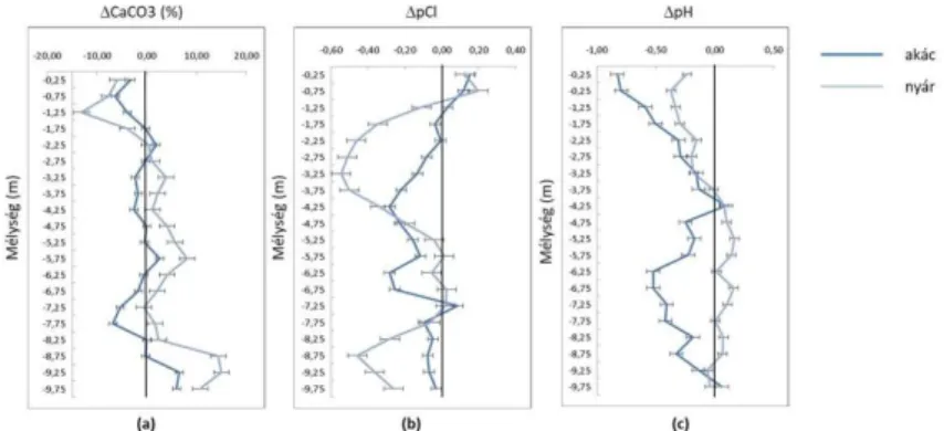
groundwater relationship were analysed by Szabó et al. (2018) on the basis of CaCO3 and Cl– accumulation. The results are illustrated in Figure 1.
Fig. 1. Mean accumulation of CaCO3 (a) and Cl– (b) and acidifying effect (c) under black locust and poplar stands (forest minus control point).
Positive values indicate CaCO3 accumulation (a), while negative values indicate Cl– accumulation (b) or acidification (c) compared to the control points (black locust n = 11, poplar n = 11) (Szabó et al., 2018).
It can be seen from the figure that the surface layers were characterised by leaching and the deeper layers by accumulation in the forest stands compared with the control, but considerable differences could be observed between poplar and black locust with respect to both chloride ions and calcium carbonate.
In the case of CaCO3 only a low level of accumulation could be detected and only in certain soil layers under black locust stands, with a maximum value of 3.48%, while a continuous, pronounced accumulation layer developed under poplar between depths of 2.25 and 7.25 m, with a maximum difference of 8.4% between the forest and control points. This can be attributed to the diverse water uptake strategies of the two species.
While black locust primarily uses soil moisture or the moisture reaching the root system by capillary water rise from the groundwater for its growth, poplar mainly satisfies its water requirements directly from the groundwater. Consequently the root zone of black locust is characterised by alternating moistening and drying out, while continuous, one-way groundwater movement, often
from considerable distances in the direction of the root system, is characteristic of poplar. The latter is naturally accompanied by greater salt accumulation.
The mechanism described above could also be observed for Cl–, but there were various differences in comparison with CaCO3. Cl– is more mobile in the soil, so even the less pronounced groundwater movement generated under black locust resulted in ion accumulation (at a depth of 5.25–7.25 m, with a maximum difference of 0.28 pCl units compared with the control). Here again there was greater accumulation under poplar (with a continuous accumulation zone below 1 m and a maximum difference of 0.54 pCl).
As the sampling areas could be divided into two distinct groups on the basis of soil texture, it was also possible to analyse the effect of soil texture.
The results revealed the presence of CaCO3 accumulation even under black locust on sandy soils, which could be explained by the more rapid groundwater movement in such soils, making it easier for accumulation regions to develop. It follows from this, that in subsoils with a finer particle composition, more intense groundwater movement is required if accumulation layers are to form. This criterion is not met by the water uptake mechanism of black locust, while the greater water requirements of poplar and its direct contact with the groundwater leads to the formation of salt accumulation zones even in these soils.
These results not only confirm earlier findings but also make it clear that the analysis of ions with diverse properties provides a more detailed picture of processes related to the groundwater.
2.3. Relationship between the daily fluctuation in groundwater level and the tree species and soil properties analysed
A separate study was made of daily fluctuations in the groundwater level at the monitoring points (Csáfordi et al., 2017). It is clear from the data that the daily fluctuations in groundwater level shadowed photosynthesis on both an annual (only occurring during the vegetation period) and a daily scale (dropping during the day and
rising at night). This is in agreement with much earlier findings that the phenomenon can be used as an indicator of groundwater uptake by the vegetation (White, 1932).
Nevertheless, there are considerable deviations between vegetation types and tree species. During the period examined (2012–2015) daily groundwater fluctuations were primarily recorded at the forest monitoring points, being observed at 73% of the points, compared with only 22% for the control areas. Among the forest stands, fluctuations in groundwater level were more characteristic of poplar and oak, being recorded more rarely under black locust.
There could be two reasons for this: in accordance with their growing site requirements, most of the black locust stands were planted on higher-lying areas, which meant that the groundwater was farther from the soil surface (6.53 ± 1.98 m) than in the case of poplar (5.53 ± 2.22 m) or oak (5.1 ± 3 m). In addition, data from the literature indicate that black locust has a shallower root system than the other two tree species, so it can be assumed that the roots did not reach the groundwater at these sampling points. This is in agreement with the findings in the previous chapter and with statements in the literature.
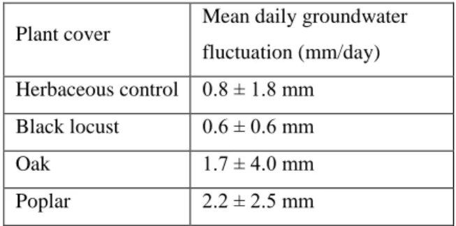
Table 1: Mean daily groundwater fluctuation under different vegetation types and tree species on the sampling areas (values multiplied by the specific yield, Sy)
Plant cover Mean daily groundwater fluctuation (mm/day) Herbaceous control 0.8 ± 1.8 mm Black locust 0.6 ± 0.6 mm
Oak 1.7 ± 4.0 mm
Poplar 2.2 ± 2.5 mm
It is clear from Table 1 that the values recorded for oak and poplar at the given sampling points and periods were considerably higher (and had greater ranges) than for black locust and herbaceous vegetation, indicating that the latter had less influence on the groundwater level.
In the case of black locust the range was also low compared with the mean values previously reported, suggesting that this tree species took up very little water directly from the groundwater. The range was much higher for the control, but this can be easily explained by the fact that this category included many vegetation types and species (grassland, cereals, maize, sunflower, alfalfa, etc.). The value was higher for oak and the highest for poplar, both of which exhibited greater deviation, again suggesting the influence of local factors. These results thus show that the groundwater uptake of forest stands is not automatically higher than that of herbaceous vegetation, but depends on the tree species.
An interesting phenomenon was noted when analysing sampling points in the Jászság region. In 2012, during the hot, wet month of July, daily groundwater fluctuation was observed not only under the forest stand, but also in the control in Jászfelsőszentgyörgy, while no fluctuation was recorded for either black locust or the control area in Jászjákóhalma, although the meteorological conditions were almost identical. This can probably be attributed to differences in soil texture and groundwater depth. On sampling areas with finer soil texture (sandy loam, loam, clay loam) in Jászfelsőszentgyörgy the upper limit of capillary water rise was as much as 1–1.5 m, which could be exploited even by the herbaceous vegetation present on the area. The sand- and coarse sand-textured soils on the Jászjákóhalma sampling area, on the other hand, had a maximum capillary water rise of 0.1–0.2 m, while measurements indicated that the groundwater reserves were at a depth of 3–3.5 m. This observation is in agreement with the previous findings and again draws attention to the importance of local factors.
Calculations made using the modified White method (Gribovszki et al., 2008) showed that during the same period the water uptake of woody vegetation on the Jászfelsőszentgyörgy sampling area (poplar: 4.7 mm/day, oak: 7.7 mm/day) exceeded that of the grassland on the control area (3.5 mm/day). A similar result was
calculated for the Kunhegyes sampling area (poplar: 3.38 mm/day, arable: 1.29 mm/day, Szabó et al., 2018).
2.4. Summarised results for all the sampling areas
It can be concluded from the results that under most forest stands the groundwater level was located at a lower depth than under associated control points with non-woody vegetation (84.8%; n = 66). This decrease in the groundwater level was most pronounced under oak, while the values recorded for poplar and black locust were very similar. It is worth noting that the highest number of cases where no decline in groundwater level was recorded under forest stands was found for poplar (19.2%; n = 26), the tree species characterised by the greatest water requirements. This contradicts the water demand data given in the literature and, together with the great deviation in the values, again reflects the significant influence of local factors.
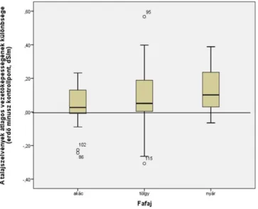
One such factor could be that, as poplar is generally planted on lower-lying areas, the water taken up is replaced to a greater extent and more rapidly. Data on the depression of the groundwater level are illustrated in Figure 2.
Fig. 2. Differences in the groundwater levels under forest stands and control areas for each tree species, omitting extreme values ( water samples were taken successfully in a total of 66 cases: black locust n = 22, oak n = 18, poplar n = 26). Positive values indicate a depression in the groundwater level under the forest. (Due to the limitations of the drilling technique, the maximum value was 10.5 m.)
One important practical result for forestry was that in no case did the salt accumulation reach a value that could endanger the forest stand.
The highest EC value recorded was 1.904 dS/m.
The variation in salt accumulation with depth followed the same pattern at all the sampling points as that described above (chapter 2.2), with salt accumulation at 0–1 m in the control and below 1 m under forest stands. The latter was greater than the accumulation under control areas, so more salt was accumulated under forest stands, averaged over the whole soil profile. The distribution of salt accumulation for each tree species is illustrated in Figure 3.
Fig. 3: Differences in the mean electrical conductivity under forest stands and control areas for each tree species, omitting extreme values (black locust n = 20, oak n = 15, poplar n = 26). Positive values indicate salt accumulation below the forests
The mean data support the basic hypothesis with respect to both groundwater depression and salt accumulation, although salt accumulation was only significant under the poplar stands (Table 2).
Table 2: Results of the paired t-test on differences in groundwater level and electrical conductivity under control and forest points. sig.: level of significance; **:mean difference between the two groups significant at the p<0.01 level
Difference in electrical conductivity
Difference in groundwater level
Black locust
t = –1.335; sig.= 0.196;
n = 23
t = –4.669; sig.= 0.000**; n = 22
Oak t = –1.188; sig.= 0.251;
n = 18
t = –5.238; sig.= 0.000**; n = 18
Poplar t = –4.003; sig.= 0.000**; n = 28
t = –4.118; sig. = 0.000**; n
= 26
These results are in accordance with the conclusions drawn from the detailed analysis of salt accumulation (chapter 2.2.) and again demonstrate the diverse water uptake strategies of poplar and black locust.
Theses
1. Compared to the control, a lowering of the groundwater level could be observed under forest stands. However, this depended not only on the greater water uptake of forest stands, but also on the influence of local factors.
Groundwater depression was detected under 84.4% (n = 66) of the forest stands compared with the associated control points, and the difference in the groundwater level was significant for all the tree species examined. This is in agreement with the international literature.
2. The salt accumulation under forest stands was significant in the case of poplar, but the extent of salt accumulation did not represent a danger for woody vegetation at any of the measuring points.
One result of practical importance for forestry is that salt accumulation in the soil could be observed under 55.6% (n = 31) of the forest sampling areas, but that it never reached a level that could endanger the long-term maintenance of the forest stand, in contrast to other published results (Nosetto, 2007). The highest value of electrical conductivity recorded was 1.904 dS/m.
3. The analysis of the salt accumulation induced by the water uptake of forest stands could be a suitable method for drawing conclusions on the water uptake strategy of the given forest stand.
The analysis of changes in total water-soluble salt content and in CaCO3 and Cl– revealed accumulation in the topsoil under the control vegetation, with a decline in salt content with depth. In contrast, low values in the topsoil, an increase with depth, followed by a decrease again in the deepest layers was recorded under woody vegetation, in line with the assumed depth of the root zone. Studies on the accumulation of CaCO3 and Cl– under poplar and black locust demonstrated that the extent of salt accumulation was determined both by the mode and intensity of water uptake by the given tree species and also by the mobility (solubility in the groundwater) of the element in question. These results make it clear that the salt accumulation induced by the water uptake of forest stands is correlated with groundwater movement. This means that by analysing the location of salt accumulation peaks and the changes in
total salt, CaCO3 and Cl–, conclusions can be drawn on how much water various tree species extract from the soil and from what depth.
4. The presence of groundwater fluctuation under forest stands during the vegetation period is a clear indication of water uptake directly from the groundwater, and can thus be used to examine the relationship between the groundwater and the root system.
The daily fluctuation in the groundwater level exhibited a clear correlation with both the annual and daily dynamics of photosynthesis, and this phenomenon confirmed the conclusions drawn from the analysis of salt accumulation. This in turn confirmed the diverse water uptake strategies of poplar and black locust, in agreement with findings reported in the literature.
It can thus be stated that the analysis of the daily groundwater fluctuations characteristic of sampling areas provides information on the water uptake mechanisms of forest stands.
Publications
1. Journal articles
Tóth T, Szabó A. 2011. Larger Gradients of Abiotic Factors Result in More Vegetative Zones in Salt-Affected Habitats. The European Journal of Plant Science and Biotechnology. 5(2): 44-47.
Szabó A, Kiss K, Gribovszki Z, Tóth T. 2012. Erdők hatása a talaj és altalaj sóforgalmára, valamint a talajvíz szintjére. Agrokémia és Talajtan. 61(1): 195-210.
Balog, K, Kalmár, J, Kuti, L, Szabó, A, Fodor, N and Tóth, T. 2013.
Homokos talajok összehasonlító ásványtani és szemcsemorfológiai vizsgálata tiszántúli erdős és füves területeken. Agrokémia és Talajtan. 62(2): 267-284.
Tóth T, Balog K, Szabó A, Pásztor L, Jobbagy E G, Nosetto M D, Gribovszki Z. 2014. Influence of lowland forests on subsurface salt accumulation in shallow groundwater areas. AoB Plants. 2014:6:
plu054 doi:10.1093. IF: 1.743
Balog K, Kuti L, Szabó A, Tóth T. 2014. Sand grain mineralogy and morphology under forest and grassland/arable fields in Eastern Hungary. Agrokémia és Talajtan. 63:49-58.
Gribovszki Z, Kalicz P, Balog K, Szabó A, Tóth T. 2014.
Comparison of an oak forest and of a pasture groundwater uptake and salt dynamics on the Hungarian Great Plain. Acta Silvatica et Lignaria Hungarica. 10:103-114.
Balog K, Gribovszki Z, Szabó A, Jobbágy E, Nosetto M, Kuti L, Pásztor L, Tóth T. 2014. Alföldi erdők hatása a felszín alatti sófelhalmozódásra sekély talajvizű területeken. Agrokémia és Talajtan. 63(2):249-268.
Balog K, Kalmár J, Kuti L, Szabó A, Tóth T. 2014. Sand grain mineralogy and morphology — a comparative study of soil particles of forest and grassy/arable parcels in Eastern Hungary. Agrokémia és Talajtan 63(1):29-38.
Balog K, Szabó A, Rásó J. 2016. The impact of soil and climate factors on forest growth. Review on Agriculture and Rural Development. 5(1-2): 19-25.
Móricz N, Tóth T, Balog K, Szabo A, Rasztovits E, Gribovszki Z.
2016. Groundwater Evapotranspiration of Forest and Agricultural Land Covers in Regions of Recharge and Discharge. iForest. 9:696- 701. doi 10.3832/ifor1864-009 IF: 1.269
Csáfordi P, Szabó A, Balog K, Gribovszki Z, Bidló A, Tóth T. 2017.
Factors controlling the daily change of water table during the growing season on the Great Hungarian Plain: a statistical approach.
Environmental Earth Sciences 76(20):675 IF: 1.569
Gribovszki Z, Kalicz P, Balog K, Szabó A, Toth T, Metwaly M, Szalai S. 2107. Groundwater uptake of different surface cover and its consequences in great Hungarian plain. Ecological Processes 6: 39.
https://doi.org/10.1186/s13717-017-0106-4
Szabó A, Gribovszki Z, Jobbágy EG, Balog K, Bidló A, Tóth T.
2018. Subsurface accumulation of CaCO3 and Cl- from groundwater under black locust and poplar plantations. Journal of Forestry Research. 10.1007/s11676-018-0700-z. IF: 0.774
2. Conference papers and abstracts
Szabó A, A "fenntarthatóság" a talaj szempontjából - Az Öko-völgy alapítvány és a MTA Talajtani és Agrokémiai Kutatóintézet együttműködésében rejlő lehetőségek. II. Fenntarthatósági konferencia, Öko-völgy alapítvány 2009. október 15., Siófok. pp:60- 61.
Szabó A, Tóth T. 2011. Relationship between soil properties and natural grassland vegetation on sodic soils. Meeting COST Action FA0901 "Putting Halophytes to Work - From Genes to Ecosystems"
Torun, Poland May 11-12, 2011. Ecological Questions 14: 65-67.
Tóth T, Kiss K, Szabó A, Csiha I, Fodor N, Gribovszky Z, Kuti L.
2011. Statistical and hydrological modeling of soil and subsoil salt- accumulation caused by tree plantations established above shallow saline groundwater. In: Ing. A Celkova (Ed.) Proceedings of peer reviewed contributions. 19th International Poster Day Transport of Water, Chemicals and Energy in the Soil-Plant-Atmosphere System.
November 10, 2011. Bratislava, Slovakia. pp:777-785. ISBN 978- 80-89139-26-2
Tóth T., Szabó A., Balog K., Fodor N., Gribovszki Z. 2012.
Faültetvények alatti sófelhalmozódás sekély talajvizű területeken. I.
ATK Tudományos Nap, Felfedező kutatások az Agrártudományi Kutatóközpontban 2012. november 14. Martonvásár, Összefoglalók p:18.
Gribovszki Z, Balog K, Fodor N, Szabó A, Tóth T. 2012. Impact of lowland forests on water table in shallow groundwater areas of the Hungarian great plain. International conference Catchment processes in regional hydrology: from experiment to modeling in Carpathian drainage basins. 28-30 October, 2012. Sopron, Hungary. pp 1-7.
Balog K, Szabó A, Gribovszki Z, Kalmár J, Fodor N, Kiss K, Pásztor L, Bátor H, Tóth T, Kuti L, Csiha I. 2013. Egy telepített erdőállomány alatti sófelhalmozódás sekély talajvízű területen.
Talajvédelem. Különszám 2013. 447-457.
Tóth T, Balog K, Szabó A, Gribovszki Z, Sándor R. 2013. Factors affecting solute accumulation under forested plots in a sandy region.
In: Tóth T, Szabó A. (eds.) 2013. COST Action FA0901 Workshop and Conference Utilization and protection of halophytes and salt- affected landscapes September 4-6, 2013. Kecskemét, Hungary. pp.
44.
Gribovszki Z, Kalicz P, Balog K, Szabó A, Tóth T. 2013.
Groundwater uptake of a poplar, an oak forest and a pasture.
Hydrocarpath International Conference, Catchment Processes in Regional Hydrology: Experiments, Modeling and Predictions in Carpathian Drainage Basins. October 27-28, 2013, Sopron, Hungary.
CD-ROM (ISBN-978-963-334-141-0)
Gribovszki Z, Kalicz P, Balog K, Szabó A, Fodor N, Tóth T. 2013.
Groundwater uptake by forest and herbaceous vegetation in the context of, salt accumulation in the Hungarian Great Plain. 2013 EGU General Assembly. Geophysical Research Abstracts.
15:EGU2013-5521.
Tóth T, Balog K, Szabó A, Gribovszki Z, Fodor N. 2013. Factors affecting vertical movements of groundwater and solute accumulation under forested plots. Hydrocarpath International Conference, Catchment Processes in Regional Hydrology:
Experiments, Modeling and Predictions in Carpathian Drainage Basins. October 27-28, 2013. Sopron, Hungary. CD-ROM (ISBN- 978-963-334-141-0)
Tóth T, Gribovszki Z, Szabó A, Balog K. 2014. Az erdők hatása a sófelhalmozódásra sekély talajvízű alföldi területeken. Alföldi Erdőkért Egyesület XXII. Kutatói Nap. Lakitelek, 2014. pp: 51-55.
ISBN 978-963-12-0848-1
Szabó A, Rásó J, Balogh K, Tóth T. 2015. Talajvízszint változási dinamika a vegetációs időszak elején ültetvényekben és a kapcsolódó kontroll területeken. Alföldi Erdőkért Egyesület XXIII. Kutatói Nap.
Kecskemét 2015. pp:81-84.
Balog K, Szabó A, Tóth T. 2016. Predictive model for expected salt accumulation due to afforestation on grasslands and croplands.
International Conference on Conservation Agriculture and Sustainable Land Uses. Budapest, Hungary. Book of Abstracts: 10- 11.
Balog K, Szabó A, Gribovszki Z, Tóth T. 2016. Soil processes evolved by the establishment of tree plantations on croplands/grasslands – evaluation of afforestation effect on the Great Plain (Hungary) EGU General Assembly, 2016. 21. April 2016.
Wien, Austria. p.12953
Szabó A, Gribovszki Z, Csáfordi P, Tóth T. 2017. Subsurface ion accumulation and tree root-groundwater connections under black locust (Robinia pseudoacacia) and poplar (Poplar sp.) stands on the Great Hungarian Plain. International conference: Catchment processes in regional hydrology: experiments, patterns and predictions. Vienna, Austria, 1. December 2017.
Szabó A, Rásó J, Csáfordi, Balog K, Toth T. Talajvízszint változási dinamika faültetvényekben és a kapcsolódó kontroll területeken több éves adatsorok alapján. Alföldi Erdőkért Egyesület Kutatói Nap Lakitelek, 2017. november 2. pp: 202-207.
3. Books and chapters
Tóth T, Szabó A. 2013. COST Action FA0901 Workshop and Conference Utilization and protection of halophytes and salt-affected landscapes September 4-6, 2013. Kecskemét, Hungary. (Abstract book)
4. Other publications, oral presentations
Blaskó L, Szabó A, A Nemzetközi Talajtani Unió Szikesedés Konferenciája (Budapest, 2009. szeptember 20-22.) Agrokémia és Talajtan 2009; 58:399-402.
Szabó A. Short introduction of salt-affected soils in Hungary. EU COST WG2 "Putting Halophytes to Work - From Genes to Ecosystems" Training School 2011. July 3-10.
5. Informative publications
Szabó A. 2011. A szikesedés rövid ismertetése, felismerése, a szikes talajok javításának lehetőségei. Őstermelő – Gazdálkodók lapja. XV.
(3); 65-67.
Szabó A. 2013. A talajdegradációs folyamatok és a védekezési lehetőségek. Őstermelő – Gazdálkodók lapja. 4. szám: 22-24.
Szabó A. 2013. A talajdegradációról röviden: Felismerés és védekezési lehetőségek. Agrofórum. 24(8):68-72.
Szabó A. 2013. A talaj vízgazdálkodásának elméleti alapjai és a vízmegőrzés lehetőségei a gyakorlatban. Agrofórum. 24(10):22-25.