laki@etszk.u-szeged.hu
college associate professor (University of Szeged, Faculty of Health Sciencis and Social Studies)
Agglomeration Issues in respect of Budapest
“The image of a city is obviously not only determined by its visually perceptible features and its cityscape. It also includes the state of its facilities, the social profile of the residents in that city, everyday life on its streets, and so on.”
(PREISICH, 1998).
A
BSTRACTBudapest agglomeration around the capital is the largest agglomeration, comprising of the most settlements, of Hungary. Its settlements are located on both sides of the Danube River and on two larger islands in the Danube River (Csepel Island and Szentendre Island). The Danube River is a line of geological demarcation, as it roughly divides the area into a lowland landscape (to the east, on its left bank) and a mountainous/semi-mountainous landscape (to the west, on its right bank), which have an impact on the network, size of and access to the settlements.
This study seeks to provide the brief history and to describe the current situation of the Budapest agglomeration in the light of data and differing theories. European countries have a long history of agglomeration, and the agglomeration process is not only ongoing in developed countries, but also subject to permanent changes in interpretation. The Budapest agglomeration covers 80 + 1 (Budapest) settlements, the majority of which have undergone dynamic development in the last 30 years.
In addition to spatial development, the Budapest agglomeration is also characterised by large growth in its population following its spatial restructuring. Road and railway infrastructure have also developed significantly. With regard to the relationship between the capital and the agglomeration, Budapest continues to play a vital role, as 25–35% of the population in the agglomeration work and use the educational institutions in the capital. Thus, the agglomeration would not exist without the opportunities offered by the capital.
K
EYWORDSagglomeration, history of Budapest, development, suburbanization
DOI 10.14232/belv.2018.4.10 https://doi.org/10.14232/belv.2018.4.10
Cikkre való hivatkozás / How to cite this article: Laki, Ildikó (2018): Agglomeration Issues in respect of Budapest. Belvedere Meridionale vol. 30. no. 4. 160–180. pp.
ISSN 1419-0222 (print) ISSN 2064-5929 (online, pdf)
(Creative Commons) Nevezd meg! – Így add tovább! 4.0 (CC BY-SA 4.0) (Creative Commons) Attribution-ShareAlike 4.0 International (CC BY-SA 4.0) www.belvedere-meridionale.hu
I
NTRODUCTIONThe description of the present situation of Budapest and its agglomeration belt is not an easy task.
Researchers and urban analysts have been concerned for decades with analysing the capital of Hungary and its surrounding area, suburbs, agglomeration belt in the context of changes of economic issues on the one hand, and of territorial and closely associated societal issues on the other hand.
The Budapest agglomeration is an administratively fragmented area comprising the capital and agglomerating settlements around the capital which are interconnected regarding their past, present and future, and interdependent. 27.8% of the population of Hungary, that is 2,743,333 persons, lived here in 2016.
However, the structure and fragmentation of an urban agglomeration is not only determined by distance from capital, but also by natural conditions, traffic corridors and local social conditions.
With this in mind, we cannot fail to interpret and take a broad look at the concept itself.
Developing areas are primarily characterised by agglomeration process, even today. The main outcome of that process is absolute concentration; both the population of cities and the area of city-regions increase, and companies become concentrated. The locating of commercial and industrial establishments in a city’s surrounding area (relocation) becomes a possible way of territorial expansion in order to ensure economic efficiency of an urban area. Thus, the concept of agglomeration covers not only the principle of population concentration, but also different mechanisms and institutional functions.
If we take the findings of ‘Agglomerációk, településegyüttesek’ (Agglomerations, settlement groups) published by the Hungarian Central Statistical Office (HCSO) as a basis, and incorporate György Kõszegfalvi’s thoughts, the concept of urban agglomeration can be defined as follows:
‘Agglomerations are settlement structures comprising of settlements which are characterised by population growth and housing construction activities. Changes during the 1990s indicate that the increasing population number and housing construction activities are not specific to centres, but to settlements surrounding the centres:people move for various reasons from centres to surrounding settlements, migrate from other regions to the surrounding suburbs, and build their homes in these settlements.
The places of work of the working population are (mainly) in centres. Manifold functional relations are established between a centre and settlements located in its immediate vicinity (place of work and place of residence, business, economic, commercial and market-related relations etc.). Intensive urban agglomeration process leads to a contiguous settlement group comprising of physically merging settlements which grow together’ (HCSO 2014).
Éva Perger defined the concept of urban agglomeration from an administrative point of view, as follows: ‘agglomerations are settlement groups which are mostly divided by administrative boundaries, but are brought together by tight social and economic relations, and functional and territorial links. Urban agglomerations are the result of the process of urbanisation and urban development, during which previously separate settlements are merged, the city exceeds its boundaries, and new settlements are established in the hinterland of the city’
(TÉRPORT, PERGER2006).
In this context, economic aspects, rather than territorial aspects, are more decisive in the definition given by the National Spatial Development Concept (NSDC 2005): ‘The Budapest agglomeration consisting of the capital and its suburban belt is the most competitive area and the most important connection point of the country, which is uniquely suitable for connecting the whole country to the European and global economic, social and cultural vitality. A basic objective is to make – in harmonious cooperation – the Budapest metropolitan region a competitive city, the main centre of the central European area, the leading centre of Central and Eastern Europe, and the economic
“core” of the Carpathian Basin through its international economic, commercial-financial and cultural-touristic role’(NSDC 2005).
The Demográfiai fogalomtár (Glossary of demographic terms)takes a demographic approach:
‘Urban agglomeration is a settlement group within which multifaceted and close cultural, economic, communal and service-related relations are established between a centre and settlements located in its vicinity. Migration from the city into surrounding villages and smaller towns plays an important role in the development of urban agglomerations’(KAPITÁNY2015).
‘Attaching surrounding settlements to a city (e.g. the creation of Greater Budapest) had been typical of previous decades, urban agglomerations were delimited later, and the tertiarization of urban economies, the unfunctionalisation of villages, and suburbanisation have made the ties of suburban areas closer by today; thus, this functional cohesion should also be reflected in the spatial structure’(FARAGÓ2008).
According to Peter HAGGETT(2001), the concept of urban agglomeration is explained by the factors of agglomeration, thus he accorded a particularly important role to economic aspects:
‘benefits derived from the high-degree concentration of the economy are collectively called agglomeration factors’.
The definition of ‘metropolitan area’ which became the focus of urban researchers’ attention in the 1970s extends interpretation frameworks. In line with that definition, urban agglomeration can develop around a large city, that is termed one-centred or monocentric agglomeration.
Another type of agglomeration is the development of towns of the same size into a settlement cluster of equal size.
‘In fact, such type of urban agglomeration does not have a joint centre, but the centres of the settlements in the settlement cluster continue to function as centres, and develop further;
i.e. several equivalent centres function at the same time. That type of agglomeration is known as multi-centred or polycentric urban agglomeration’(BERNÁT– BORA– FODOR1973). (It should be noted that in the case of a multi-centred or polycentric urban agglomeration, surrounding smaller settlements are often absorbed into urban areas.)
Lastly, as a conclusion to the description of urban agglomeration-related concepts and processes, we have to introduce a concept which describes urban agglomeration as the closer and closer ties of administratively still independent settlements to a large city, in which employment, trade relations and traffic connections play an active role. Population movements into suburbs within a large city (suburbanisation) and other processes thereafter (the development of residential areas and the construction of shopping centres etc.) strengthen that process.‘Thereby, the territory of a large city shows greater and greater increase, while smaller settlements almost merge with this city.
The resulting settlement clusters are called urban agglomeration’(SZÛCSNÉ– SZÛCS2007).
From an overall perspective, an urban agglomeration is therefore a system in which settlements have active and daily relations with each other, however the central settlement of an urban agglomeration (in economic, social and territorial terms) – in this case, Budapest – still shapes the everyday life of the settlements. Main drivers primarily are urbanisation, the spreading of urbanised lifestyle, the development of the settlements, the development of the specific roles of the settlements, and the development of regional relations; the interrelation of the settlements and the distribution of tasks between the settlements are less decisive factors. However, territorial functionality, and genuine cooperation between the settlements are also key factors.
The concept of urban agglomeration is often equated with suburbanisation. Some of the literature describe suburbanisation as migration from a large city into surrounding villages and smaller towns, which actually plays an important role in the development of urban agglomerations. ‘The process of suburbanisation is enhanced by growth (growth of the total population), and the change in the internal structure of towns. Several people previously living in a large city no longer live and work in the same urban space; they rather choose to live in an agglomeration belt and commute to their workplace. Suburbs are built-up areas in the outer edge of a city, outer parts of a conurbation or outside a city’s administrative boundary’(TÉRPORT2017).
Suburbanisation has become a permanent process after the 1990s. Suburbs are mostly determined on a human ecological basis, when regarding them as a system that forms a coherent unit with a city.
In this approach, a significant proportion of researchers consider suburbs as mere residential areas.
Another line of the human ecological approach highlights the principle of dependence; ‘the other focus is the dependence of suburbs on a city, i.e. on its municipal property and services; the degree of dependence is expressed as the ratio of people commuting into a central city’(TÍMÁR1999).
As determined by the Hungarian legal environment and international literature, suburbanisation is the process of a shift of the population and economic activities (industry and services) away from urban centres towards the surrounding settlements. An essential characteristic of suburbanisation is out-migration from centres, however the same process applies for economic functions. In fact, the emergence of urban agglomerations is the result of suburbanisation processes. All this leads to a complex activity which has an effect both on the economy and society of the settlements
of a given territorial unit. Overall, that conceptual framework prepares the ground for and makes the substance of the concept of urban agglomeration easily understandable. The concept refers to a long-standing spatial phenomenon which undergoes and is subject to permanent changes to its area and society.
H
ISTORY OF THEB
UDAPESTA
GGLOMERATION‘Metropolitan development in the 20th century has become an integral part of economic and social development; in fact, it is one of the conditions for development. The need to direct or at least influence development is a political issue that all societies has to face. Traditional towns are unravelling, and the new production method facilitates the territorial differentiation of functions’(MEGGYESI2005).
The history of the development of the Budapest agglomeration started with the merger of Pest, Buda and Óbuda (Old Buda) in 1873. ‘The increase in employment in the industrialising city exceeded the number of employees in certain periods, which triggered a migration of people from rural areas into the capital. All this directly affected the settlements surrounding the capital; thus, the number of inhabitants of the settlements around the capital showed a significant increase.
’Opinions were already offered as to the organisation of relations between Budapest and its rapidly increasing suburban area (conurbation) as early as the turn of the century. Ferenc Harrer drew up a proposal for reforming public administration in 1908, however both Pest County and the capital opposed and rejected the proposal. The issue of the Budapest agglomeration slipped down the agenda following the First World War. Ferenc Harrer raised again that issue in 1933; Act on urban planning and building administration – that placed the approval of plans prepared for suburbs of Budapest into the competence of Budapest Public Works Committee – was adopted in 1937.
Even compared to concepts of today, modern visions for public administration were outlined in the concepts of the law in order to establish a single administrative organisation of the core, its closely related suburbs and rural ‘protective belt’.
Greater Budapest was finally created in 1950 by attaching 23 surrounding settlements to the administrative area of the capital. The creation of the greater city was not at all motivated by the integration of the agglomeration belt with the capital as a political consideration; indeed, the Socialist state power wished to ensure the appropriate composition of urban ‘working population’
by attaining this objective. However, it took ten years for the first General Master Plan covering the entire capital to come into force. That delay reliably reflected the strategic direction of the then urban policy which promoted the integration of the former suburbs only to a very limited extent.
The capital has acquired a new status and has enjoyed county rights, the districts of Budapest have established district councils, and the surrounding settlements have become parts of Pest County and different districts of Pest County. The governance of those settlements was not in their own hands.
The General Master Plan for urban development of Budapest and its surrounding area, approved in 1960, regarded 64 settlements within a distance of approximately 15 km of the boundaries of the capital as parts of the Budapest conurbation. The 1950s and 1960s were characterized by the acceleration of urbanisation processes; migration into the metropolitan area of the capital continued even in the 1970s.
The General Master Plan of Budapest, drawn up in 1960, was aimed at developing its outer areas.
‘The Plan underlined that the settlement groups of the agglomeration belt were to attach to district centres designated for development in a tentacle-like manner, while these settlements should not become parts of Budapest’(KOCSIS2009).
‘The Budapest agglomeration was firstly delimited in 1971. Then, 1005/1971. (11.26.) Government Decision listed 45 settlements as parts of the agglomeration belt of the capital’(GERGELY2009).
The basis for that delimitation was the strength of transport and recreational relations, and the volume of commuting traffic. The delimitation had long been subject of debate; later more and more scientific studies evidenced that new factors should be taken into account in delimitation.
The 1980s marked a turning point both in the development of the Budapest agglomeration and in the restructuring of public administration. The districts of counties were abolished in 1984.
The abolishment of county districts and the decommitment of the rigid rules of workers’ councils were a further step towards the establishment of a local-government system. The administrative division of the capital and its surroundings was affected by that system, as a few settlements of the conurbation had organized a separate urban periphery.
The new General Master Plan relating to the capital was approved in 1989. The new Plan took the agglomeration belt (‘ring’) into account, however a specific metropolitan viewpoint prevailed in it. It envisaged a role of serving the capital for the settlements of the conurbation, i.e. the Plan also based its visions on the concept that the population of the agglomeration belt was to continue to work and use the majority of public services in Budapest.
After the adoption of the amendment to the Constitution, the Parliament created Act LXV of 1990 on Local Governments and Act LXIV of 1990 on the Election of Representatives in Local Governments and of Mayors. Under the new Act on local governments, the powers and tasks of counties have been significantly reduced, and counties have lost their former character of being intermediate administrative level. Thereby, the settlements of the agglomeration belt have been put on an equal footing in legal terms with the capital and the districts of the capital.
The Act on local governments and the Act on the capital have established a highly fragmented structure of local government in the Budapest area. The new system has not provided a solution with regard to the harmonisation of cross-boundary public services or spatial development tasks.
As the Act has given local governments the opportunity to cooperate voluntarily with one another, however it has been soon obvious that voluntary cooperation is not adequate to fill the gap arising from the lack of regional coordination. As regards the capital and the settlements of the agglomeration belt, the new system has kept administrative disparities between the capital and its region. The agglomeration belt has continued to administratively belong to Pest County, thus it has constituted an administrative territorial unit with other local authorities that have not been part of the region. The Act on local governments has offered four types of associations to settlements: office of district-notary, official administrative association, association for the (joint) direction of certain institutions, and joint body of representatives. In addition to these options offered, local governments have been entitled to establish any other association, or subregional, regional or national interest association.
The cooperation between local governments has been developed very slowly in the Budapest agglomeration, and has not provided an answer to the problems of the agglomeration belt.
The establishment of associations and interest associations has primarily followed two association trends.
In addition to the forms of association related to the most pressing issues – mainly the operation
and development of basic health and social welfare provisions, basic infrastructure and technical infrastructure –, loose subregional associations of settlement local governments have also appeared.
Various specialist reports indicated as early as the beginning of the 1980s that agglomeration processes had already stretched the framework set up by legislation, however the new legislation was adopted only after the regime change in 1997.1In autumn 1994,the Hungarian Parliament amended the Act on local governments. The amended law has aimed primarily at providing a solution to the problems arising from the administrative disparities of Budapest. The biggest flaw of the amendment is that it has not given any possibility to administratively connecting the capital with its agglomeration belt. Even though the development of Budapest and the surrounding settlements has been closely interrelated (common economic-social problems, and the establishment of association relationships) following the regime change, and their network of relationships has become multifaceted, two-way and closer. Government Decree 89/1997. (V.28.) designated the capital and 79 settlements as the Budapest agglomeration area in 1997, thus the Budapest agglomeration officially covers 81 settlements – the reason for the change in the number is not the change of delimitation, but the separation of two settlements – today (based on the research by Júlia Gergely).
‘The Hungarian Central Statistical Office altered former official delimitation with regard to the administrative area of Budapest and 78 settlements in finally 1997, thus the agglomeration belt has been significantly increased’(www.terport.hu).
The lines of delimitation valid at present were established in 2005, which have also determined the area of the agglomeration. The agglomeration of 81 settlements covers 38 towns, 11 large villages and 32 villages. (See Map 1.)
A
GGLOMERATION AND ITSR
OLE‘The Budapest agglomeration is thus an administratively fragmented area comprising the capital and 80 agglomerating settlements around it, however its spatial structure is coherent. It is the only real metropolis of Hungary which has a metropolitan agglomeration that can be regarded as significant even at a European level’(SPATIAL
PLAN OF THEBUDAPESTAGGLOMERATION, 2011).
That ‘formation’ is the most dynamically developing area of the country, in which both Budapest and the settlements in the region have a crucial social and regional role.
There has been a significant change in the agglomeration since the 1990s. Contributing factors have been economic changes in the agglomeration, and political and administrative decisions which have been forming their relations in different ways over the last 27 years.
‘The agglomeration is Budapest and its interconnected, interdependent and administratively fragmented area’(according to the Urban Development Concept 2011). Despite that fact, the substantial cooperation between Budapest and the surrounding settlements is tension-filled and is struggling with several unresolved problems.
1Under the Act XXI of 1996 on Regional Development and Regional Planning.
‘Changes in the urban space of Budapest are quite complex in nature. The main reason for this is that the processes of large Western European cities took place, for historical reasons, in a short period of time. After the Second World War, the Socialist regime artificially put the [same] processes [in Hungary] on an entirely different track’
(KOCSIS2013).
Against this backdrop, the current (imbalanced) situation of the Budapest agglomeration becomes easier to understand. When giving a complex description of an urban agglomeration, one can use two approaches. The first one is the use of the perspective of settlements when the model of the assessment of the types of settlements with town or village status is a primary consideration, and the second approach means a sectoral focus on the examination of a group of settlements from the perspective of sectors. In both cases, the actual agglomeration bonding lies in day-to-day relations between settlements, the use of institutions, and economic formations.
MAP1Settlements of the Budapest Agglomeration (Prepared by Attila Fekete, 2017.)
‘The extensive growth of the agglomeration belt has stopped in parallel with the decrease of the staffing needs of Budapest. The out-migration of well-off sections of the population from the capital into micro-districts in conurbations providing a more comfortable living environment – the Buda side, the group of settlements along the River Danube, and the north- eastern sector in the area of the Hills of Gödöllõ in the Pest side (see the settlements of the sector below) – has become a mass phenomenon’(ENYEDI– HORVÁTH2002).
The number of population living in the capital and its agglomeration belt has been following an upward trend since the 1990s, the reasons for which are two-fold: out-migration from Budapest on the one hand, and in-migration from different parts of the country into the agglomeration belt on the other hand. When speaking about out-migration from the capital, the towns and villages which are close to the capital and have good transport links have always been favoured. That aspect has been less relevant for those moving from different areas of the country into the agglomeration belt;
proximity to Budapest does not necessarily mean active participation in employment.
The conurbation of Budapest consists of six sectors which have received their names according to their orientation by the cardinal points. Most settlements are in the North-Western sector, the Southern sector is most highly populated, and the proportion of urban population is highest in the Northern sector.
MAP2‘History’ of the Boundaries of Budapest (Source: http://www.tankonyvtar.hu/hu/
tartalom/tamop412A/2010-0019_Telepulesepiteszet/ch03s03.html)
TABLE1Settlements of the Budapest Agglomeration by Sectors (2016) (Source: own edition based on the data from the Gazetteer of Hungary, 2016.)
It can be provisionally concluded in the sectoral analysis of the Budapest agglomeration that the popularity of the Western and North-Western sectors has shown a gradual upward trend compared to the other sectors due to social and territorial differences. The educational attainment and employment rate of the total population in those two sectors are high, and the ‘quality-of life’
indicator is also above-average. The same only applies to very few settlements in the other four sectors (Vác, Veresegyház, Göd, Gödöllõ, Diósd and Érd).
The relationships of the settlements of the sectors with the capital are different, however rather active. The relationship of the nearest settlements with the capital can be considered close, as their inhabitants travel to work, commute on a daily basis to Budapest, and use of its institutions and services.
Northern Eastern South-Eastern Southern Western North-Western
Sesctor
Csomád Csömör Alsónémedi Délegyháza Biatorbágy Budakalász
Csörög Erdõkertes Ecser Diósd Budajenõ Csobánka
Dunakeszi Gödöllõ Felsõpakony Dunaharaszti Budakeszi Dunabogdány
Fót Isaszeg Gyál Dunavarsány Budaörs Kisoroszi
Göd Kerepes Gyömrõ Érd Herceghalom Leányfalu
Õrbottyán Kistarcsa Maglód Halásztelek Páty Nagykovácsi
Szõd Mogyoród Ócsa Majosháza Perbál Pilisborosjenõ
Szõdliget Nagytarcsa Üllõ Pusztazámor Telki Piliscsaba
Vác Pécel Vecsés Sóskút Tinnye Pilisjászfalu
Vácrátót Szada Százhalombatta Tök Pilisvörösvár
Veresegyház Szigethalom Törökbálint Pilisszántó Szigetszentmiklós Zsámbék Pilisszentiván
Taksony Pilisszentkereszt
Tárnok Pilisszentlászló
Tököl Pócsmegyer
Pomáz Remeteszõlõs Solymár Szentendre Szigetmonostor Tahitótfalu Üröm Visegrád
10 settlements – 5 settlements with town status and 5 settlements with village status – belong to the Northern sector of the Budapest agglomeration. Out of the towns of the sector, Dunakeszi is characterised by the greatest population growth rate: a 61.5% increase in the population of the town took place between 1990 and 2016, however it is necessary to point out that this settlement was affected by the largest flow of people moving out from Budapest between 2001 and 2011.
Besides Dunakeszi, Õrbottyán also showed a high population growth rate (57.3%). Õrbottyán was created in 1970 with the unification of two villages, named Õrszentmiklós and Vácbottyán;
it gained town status in January 2013. Its population has further grown after the settlement won town status. Fót and Gödöllõ showed a population growth by 5000–6000 inhabitants between 1990 and 2016. Göd gained town status in 1999, and Fót in 2004, thereby the prestige of these settlements has reached an even higher level. There has been a slight decline in the population of Vác, a town of the Northern sector of the agglomeration belt. There could be lots of reasons behind that trend, such as migration into a surrounding settlement or Budapest, or its diminishing popularity. Nevertheless, that town still has stable functions and urban role in the agglomeration belt.
Experts in the field of urban agglomeration have often raised the question of whether Vác can be considered a settlement of the agglomeration belt.
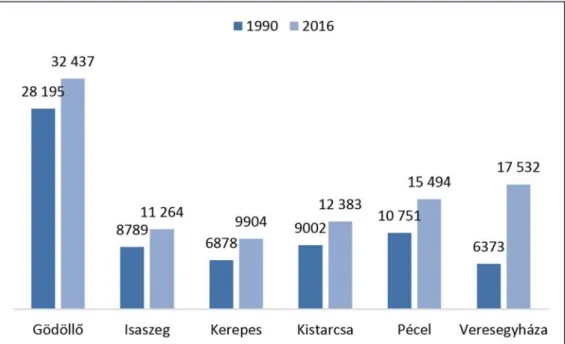
FIGURE1Urban Population Changes in the Northern Sector of the Budapest Agglomeration (Source: own edition based on the data from the Gazetteer of Hungary, 2016.)
TABLE2Year of Gaining Town Status
Town name Dunakeszi Fót Göd Õrbottyán Vác
Year 1977 2004 1999 2013 1900
The two largest towns of the Eastern sector are Gödöllõ and Veresegyház. The urban autonomy of Gödöllõ has a prominent and strong role to play, as a consequence of which its involvement in the life of the agglomeration can be hindered.
The population of Gödöllõ has grown by 8.7% during the past 26 years, while the population of Veresegyháza has almost quadrupled (increased by 275%). High-quality agglomeration living area has been developing in that settlement since the 1990s. The settlement has a special role in the agglomeration, however it makes heavy demands on the capital.
The third largest town of the sector is Pécel functioning as town since 1996. It also applies to the settlement that its town status has raised its prestige – the number of its inhabitants increased by 50% between 1990 and 2016 –, and the majority of its inhabitants work in the capital and use the services of the capital. Kerepes and Kistarcsa functioned as settlement Kerepestarcsa in 1978, they separated in 1994, and they take their decisions as separate towns today. Kistarcsa won town status on 1 January 2005, and Kerepes on 1 June 2013. Actually, only Gödöllõ has long-standing town status in the sector, the other settlements of the sector – like the settlements of the agglomeration belt – have a newly gained town status.
Figure 2Urban Population Changes in the Eastern Sector of the Budapest Agglomeration (Source: own edition based on the data from the Gazetteer of Hungary, 2016.)
TABLE3Year of Gaining Town Status
Town name Gödöllõ Isaszeg Kerepes Kistarcsa Pécel Veresegyház
Year 1966 2008 2013 2005 1996 1999
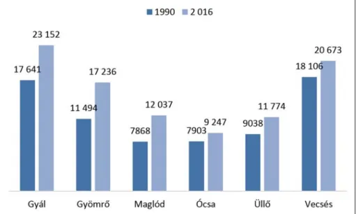
The South-Eastern sector of the agglomeration could basically be regarded at the time of Hungary’s regime change and in the following decade as a poorer and less developed area regarding its social status compared to the other sectors. The settlements of the sector have very close links with the capital due to the commuting workers living in these settlements. The population of these settlements increased significantly between 1990 and 2016, as a high number of people moved from Budapest and the southern counties into the sector due to lower market prices.
Out of the settlements of the sector, there was a notable increase – by 15–35% – in the population of Gyál, Gyömrõ and Maglód between 1990 and 2016. The settlements of the sector gained town status in the early 2000s, with the exception of Gyál which won this status in 1997; data collected shows that the change in their status only has had a limited impact on their population growth rate.
Only the town of Maglód stands out clearly from that group; it was affected by the 19th largest out-migration from Budapest between 2001 and 2011.
The Southern sector has been a favoured area of the Budapest agglomeration even before the regime change. Érd, Diósd, Halásztelek and settlements along the south line have been favoured by people who want to move closer to Budapest and have modest incomes. The population number of the town Érd has been increasing since the 1990s, however there has been a clear change in the population of the other settlements in the sector since the 2000s. The population number increased by 266% in Diósd and by 66.8% in Érd which is in the 2nd place in a ranking of the settlements of the agglomeration belt most affected by out-migration from Budapest
TABLE4Year of Gaining Town Status
Town name Gyál Gyömrõ Maglód Ócsa Üllõ Vecsés
Year 1997 2001 2007 2007 2005 2001
Figure 3Urban Population Changes in the South-Eastern Sector of the Budapest Agglomeration (Source: own edition based on the data from the Gazetteer of Hungary, 2016.)
(between 2001 and 2011). In addition, it also should be noted that more than 60% of people living in that sector are commuting to Budapest or to a nearby settlement.
Among the towns of the sector, Szigetszentmiklós stands out for being the third most popular target town of out-migration from Budapest; an 87.5% increase can be seen in this regard. It is also characterised by an active day-to-day relationship with the capital, which is mainly based on the use of its institutions. The population of Halásztelek grew by 57.2%, and the population number of Százhalombatta increased by 12.2% during the same period. The specificity of the Southern sector is based on the fact that a significant percentage of its population actively use the centre of the agglomeration; people moving out from Budapest favour settlements nearer to Budapest, while people moving from different parts of the country prefer settlements distant from the capital.
Some settlements of the sector have had town status for 30–40 years, which have had a direct impact on their development and their role played in the agglomeration. The decades-long active relationship and close cooperation of certain towns (Érd and Százhalombatta) with the capital should also be highlighted with regard to their role.
FIGURE4Urban Population Changes in the Southern Sector of the Budapest Agglomeration (Source: own edition based on the data from the Gazetteer of Hungary, 2016.)
TABLE5Year of Gaining Town Status
Town name Diósd Dunaharaszti Dunavarsány Érd Halásztelek
Year 2013 2000 2004 1978 2008
Town name Százhalombatta Szigethalom Szigetszentmiklós Tököl
Year 1970 2004 1986 2001
The Western sector is a territorial unit providing living area for higher social strata.
The most innovative and most popular settlements – in respect of out-migration from Budapest – (Budaörs and Törökbálint) are in that sector. Even though the settlements are integral parts of the agglomeration belt, their inhabitants mainly use the infrastructure of the capital. All settlements of the sector are characterised by continuous increase in their population number.
Their absolute proximity to Budapest causes their almost inseparable character from the capital.
Budaörs was the 4th settlement in a ranking of settlements most affected by out-migration from Budapest, and has been preferred by the higher social strata of the former residents of Budapest.
The population grew by 43.2% in Budaörs, by 41.5% in Törökbálint, by 38.4% in Zsámbék and by 80.2% in Biatorbágy between 1990 and 2016. That enormous increase of the population of Biatorbágy has also affected the structural change of the settlement; the former settlement with a traditional economic structure has become a commuter town and service-centre. At least two-thirds of people living in the sector work in Budapest or its vicinity, and use the services of the capital or its surrounding settlements. Generally, it applies to almost all settlements of the agglomeration.
Out of the 12 settlements of the sector, there are 5 towns; Budaörs is the only town of them which won town status decades ago, the other towns gained their town status only in the early 2000s.
Town status has played a particularly significant role in the case of Biatorbágy which experienced a significant growth of its population between 2001 and 2011.
TABLE6Year of Gaining Town Status
Town name Biatorbágy Budakeszi Budaörs Törökbálint Zsámbék
Year 2007 2000 1986 2007 2009
FIGURE5Urban Population Changes in the Western Sector of the Budapest Agglomeration (Source: own edition based on the data from the Gazetteer of Hungary, 2016.)
The North-Western sector is the other continuously developing green-belt area of the agglomeration belt. The sector consists of 23 settlements: 6 towns and 17 villages. The smallest, but historically very important town, Visegrád can be found in that sector. Visegrád gained town status at the turn of the Millennium. The population of the towns continually grew between 1990 and 2016, especially in the case of Szentendre. Population increased by 33% in Szentendre, by 34.3% in Pomáz, by 25.6% in Pilisvörösvár and by 57.5% in Piliscsaba. Piliscsaba has become a university town, which has certainly triggered urbanisation and the spreading of urbanised lifestyle.
Overall, the settlements of the sector are very popular; besides towns, small villages have also played a similar role. The towns of the sector have very close links with Budapest, while small settlements show strong cohesion with each other. In a previous study (LAKI2008), our experience indicated that the social cohesion of the region proved to be excessively strong compared to that of the other sectors.
Out of the towns of the sector, Szentendre was the first settlement which gained town status, the other 5 settlements won this status before the turn of the Millennium or in the last few years.
The population of 81 settlements showed a 10.06% growth between 1990 and 2016. When excluding Budapest, there was a population growth of 55.9% in the settlements of the agglomeration belt in the same period. The data of the population census 2001 indicates that the population declined by almost 10% (9.42%) in Budapest between 1990 and 2001. As already mentioned above, out-migration
TABLE7Year of Gaining Town Status
FIGURE6 Urban Population Changes in the North-Western Sector of the Budapest Agglomeration (Source: own edition based on the data from the Gazetteer of Hungary, 2016.)
Town name Budakalász Piliscsaba Pilisvörösvár Pomáz Szentendre Visegrád
Year 2009 2013 1997 2000 the 1900s 2000
to the suburbs became more active in that period. The capital has continued to function as a ‘supply system’ in the sense of employing commuters, satisfying the needs of people using its education institutions, and providing different services.
The importance of settlements with town status is undeniable in the development of agglomeration roles. The question is how the capital and the 80 settlements belonging to the metropolitan area can execute functions resulting from their involvement in the life of the agglomeration, either on a sectoral or a professional basis.
The settlements of the agglomeration belt mainly won town status after the 1990s. Only a few settlements of the agglomeration belt gained town status after the 2010s.
That factor determines the strength of the relationship between Budapest and the agglomeration belt, as the exploiting of opportunities arising from the proximity of the capital depends largely on labour market situation at local level, the satisfying of local needs and other types of use of the services or institutions in the capital.
The population of Budapest and the agglomeration belt showed an upward trend in recent years.
While the population decline rate of the capital was significant in the 2000s, there was a robust growth in the population of the settlements of the agglomeration belt. All that plays a prominent role in the assessment of the situation of the agglomeration belt of the capital, as it appears that there is some kind of link between the capital and the surrounding settlements. However, the settlements of the agglomeration belt are not able to specify their relations with Budapest. In this regard, the question arises as to what links there should be between the settlements of the sectors and the capital, which would make the scope of functions expected from the agglomeration belt of the capital and its settlements characterizable.
FIGURE7 Types and Number of Settlements in the Budapest Agglomeration on 1 January 2016 (Source: own edition based on the data from the Gazetteer of Hungary, 2016.)
FIGURE8Year of Gaining Town Status by the Settlements of the Agglomeration Belt between 1990 and 2016 (Source: own edition based on the data from the Gazetteer of Hungary, 2016.)
FIGURE9Population Changes in Budapest and the Settlements of the Agglomeration Belt between 1990 and 2016 (persons) (Source: own edition based on the data from the Gazetteer of Hungary, 2016.)
The second group of reflections regarding the agglomeration belt lies in the relations between the settlements. When adopting the sectoral approach, the settlements are interrelated in different ways, which often include daily cooperation. There is a stronger synergy between the settlement groups in the Western and North-Western sectors compared to that of the settlements in the Eastern and South-Eastern sectors, the reason for which may be the different times of out-migration from Budapest into the given sectors. Another factor that further strengthens the links between the settlements is the strength of cooperation between districts and subregions. Their common regional interests are important in this regard, provided that these settlements are struggling with common regional-social problems; it is clear that the cooperation of settlements is more dynamic in this case contrary to the case when they are not facing any difficulties.
S
UMMARY‘Clearly, agglomeration/suburbanisation processes have revealed themselves not only in the change of the functions of settlements, but also in its impact on demographic and employment situation’(BELUSZKY2015).
This study provides an outlook with regard to the actual population changes and situation of the agglomeration belt of the capital and its settlements. This study which does not contain in-depth analyses presents an outlook for the group and substance of different concepts relating to urban agglomeration, for frameworks and processes related to this phenomenon, the specific features of urban agglomeration at national and international levels, and the implementation of the process of suburbanisation closely linked to urban agglomeration. The regional specificities of an urban agglomeration can only be observed in historical context; Hungarian historical analyses of urban agglomeration have taken an administrative or a socio-geographical approach.
It makes those analyses biased on the one hand, and the results in the assessments of urban agglomeration are given from different angles.‘Cultural-historical and social factors almost predestinate conflicts between the capital and the settlements in the agglomeration belt, the atmosphere of mistrust and their inability to cooperate. The specific administrative provisions applicable to Budapest and the agglomeration belt, and political controversies and interests further aggravate the problem’(KOCSIS2015).
The agglomeration belt of the capital, which comprises 81 settlements, is divided into six sectors, thereby each sector can be assessed according to their own specificities. The settlement groups following different paths towards development have different relationships with the capital, and they thus ensure or reject agglomeration opportunities provided by Budapest (transport and services). The study provides a separate assessment of the social and spatial development of each sector, and underlines population growth without explaining the reasons behind it.
Since the most important aspect is that the population of towns and settlements has significantly increased, the collection of alternatives is an unimportant detail in this case. The fact remains that the agglomeration to the capital is today the largest territorial unit in the map of Hungary.
By reason of its size, it is also clear that it is struggling with several conflicts, clashes and problems yet to be solved.
B
IBLIOGRAPHYBELUSZKY, PÁL(2003):Magyarország településföldrajza. Általános rész.[Urban Geography of Hungary. General Part]. Pécs – Budapest, Dialóg Campus Kiadó.
BELUSZKY, PÁL(2015): Máig érõ múlt (Past Reaching the Present). In: SIKOST. TAMÁS(ed.):
A Budapesti Agglomeráció nyugati kapuja (Western Gate of the Budapest Agglomeration).
Budaörs, Törökbálint, Biatorbágy. Gödöllõ, Szent István Egyetem – Enyedi György Regionális Tudományok Doktori Iskola. 9–18
BERNÁT, TIVADAR– BORA, GYULA– FODOR, LÁSZLÓ(1973):Világvárosok – nagyvárosok (Metropoles, Cities). Budapest, Gondolat.
BERZALÁSZLÓ(ed.) (1993):Budapest lexikon A–K (Budapest Lexicon Vol. 1).Budapest, Akadémiai Kiadó.
DÖVÉNYI, ZOLTÁN– KOVÁCSZOLTÁN(1999): A szuburbanizáció térbeni-társadalmi jellemzõi Budapest környékén. [Spatial-Social Characteristics of Suburbanisation in the Outskirt of Budapest]
Földrajzi Értesítõ vol. XLVIII, no. 1–2 1999, pp. 33–57. http://www.mtafki.hu/konyvtar/kiadv/
FE1999/FE19991-2_33-57.pdf (accessed 20 February 2017)
ENYEDI, GYÖRGY– HORVÁTH, GYULA(2002): Táj, település, régió (Areas, Settlements and Regions).
Budapest, MTA TK – Kossuth Kiadó (Magyar Tudománytár sorozat 2.).
FARAGÓ, LÁSZLÓ(2008): A funkcionális városi térségekre alapozott településhálózat fejlesztés normatív koncepciója. [The normative concept of settlement network development based on functional urban areas].Falu Város Régió2008/3, http://regionalispolitika.kormany.hu/download/d/e1/
31000/FVR_2008_3_NTH.pdf (accessed 10 December 2017).
GIDDENS, ANTHONY(2008): Szociológia (Sociology). Budapest, Osiris Kiadó.
HAGGETT, PETER(2006):Geográfia. Globális szintézis (Geography: A Global Synthesis).
Budapest, Typotex.
HIDAS, ZSUZSANNA(ed.) (2014): Agglomerációk, településegyüttesek. Magyarország településhálózata 1 (Agglomerations, Settlement Groups. Hungary’s Settlement Network). Budapest, Hungarian Central Statistical Office (book form).
KAPITÁNY, BALÁZS(szerk.) (2015): Demográfiai fogalomtár. [Glossary of Demographic Terms]
Budapest, KSH Népességtudományi Kutatóintézet. http://demografia.hu/hu/tudastar/fogalomtar/
27-agglomeracio (accessed 04 February 2017).
KOCSIS, JÁNOSBALÁZS(2008):Városfejlesztés és városfejlõdés Budapesten. PhD dolgozat (Urban Development in Budapest, 1930–1985. PhD thesis), http://doktori.tatk.elte.hu/2008_Kocsis.pdf (accessed 20 February 2017).
KOCSIS, JÁNOSBALÁZS(2013): Városi szétterülés folyamatai Budapesten és környékén (Urban Sprawl around Budapest), https://storage.googleapis.com/vshu/Varosi-szetterules.pdf (accessed 04 February 2017)
MEGGYESI, TAMÁS(2005):A 20. század urbanisztikájának útvesztõi.[Labyrinth of Urbanism of the 20th Century]. Budapest, TERC.
Migráció és lakáspiac a budapesti agglomerációban. [Migration and Housing Market in the Budapest Agglomeration] (2014). Budapest, Központi Statisztikai Hivatal. https://www.ksh.hu/docs/hun/xftp/
idoszaki/regiok/bpmigracio.pdf (accessed 12 February 2017).
NSDC 2005.:97/2005. (XII. 25.) OGY határozat az Országos Területfejlesztési Koncepcióról.
[National Spatial Development Concept 2005.] http://www.kvvm.hu/cimg/documents/
97_2005_OGY_hat_OTK_rol.pdf (accessed 4 March 2017).
PREISICH, GÁBOR(1998): Budapest városépítésének története 1945–1990. (History of Budapest’s Urban Development 1945–1990).Budapest, Mûszaki Kiadó.
SIKOS, T. TAMÁS(ed.) (2015):A Budapesti Agglomeráció nyugati kapuja (Western Gate of the Budapest Agglomeration). Budaörs, Törökbálint, Biatorbágy.Gödöllõ. Szent István Egyetem – Enyedi György Regionális Tudományok Doktori Iskola.
SZELÉNYI, IVÁN(ed.) (1973):Városszociológia.[Urban Sociology] Budapest, Közgazdasági és Jogi Könyvkiadó.
SZABÓ, TAMÁS(2016): Városkörnyéki önkormányzati kooperációk az agglomerációs térségekben (Cooperation among Local Governments in Urban Areas). http://phd.lib.uni-corvinus.hu/899/1/
Szabo_Tamas.pdf (accessed 15 January 2017).
TÍMÁR, JUDIT(1991): Elméleti kérdések a szuburbanizációról (Theoretical Guestions on Suburbanisation).
Földrajzi értesítõ. vol. XLVIII. no. 1–2, 1999, pp. 7–31. http://www.mtafki.hu/konyvtar/kiadv/
FE1999/FE19991-2_7-31.pdf (accessed on 25 February 2017).
TÓTH, GÉZA– SCHUCHMANN, PÉTER(2010):A Budapesti agglomeráció területi kiterjedésének vizsgálata (The Examination of Territorial Coverage of the Budapest Agglomeration).Területi Statisztika 2010/5, http://www.ksh.hu/docs/hun/xftp/terstat/2010/05/toth_schuchmann.pdf (accessed 13 January 2017).
VIDOR, FERENC(ed.) (1979): Urbanisztika.Válogatott tanulmányok (Urbanism. Selected Studies).
Budapest, Gondolat.