MARTON pé c si
GEOMORPHO- LOGICAL
REGIONS
„HUNGARY
AKADÉMIAI KIADÓ, BUDAPEST
M . Pécsi
GEOMORPHOLOGICAL REGIONS OF HUN G ARY
STUDIES IN GEOGRAPHY IN HUNGARY, 6
The author’s aim is to give a picture o f the form groups constituting the individual regions in Hungary. Details on their genetics, structure and types are included. The elaboration o f the principle and methodical approach o f classification by regions is based on the author’s extensive research who also established the taxonom ical units in th e various regions.
The relief properties, such as geostruc- tural, morphological, litological, oro- graphical, have been considered as decisive factors in this work. I t is owing to th is com plex treatm ent o f the subject th at the hierarchy o f the regions could be determined and their boundaries precisely delimited.
A K A D É M I A I K I A D Ó Publishing H ouse o f th e Hungarian
A cadem y o f Sciences BU D A PEST
GE OMORP HOL OGI CAL R E GI ON S
OF H U N G A R Y
S T U D I E S IN G E O G R A P H Y IN H U N G A R Y , 6
G eographical R esearch I n s titu te , H ungarian A cadem y of Sciences
Chief editor:
M. PÉCSI
Editorial board:
Á. BORAI, GY. ENYEDI, B. SÁRFALVI, and J. SZILÁRD
GEOMORPHOLOGICAL REGIONS
OF HUNGARY
by
MÁRTON PÉCSI
A KA D É MI A I KI ADÓ, B U D A P E S T 1970
Translated by B. Balkay
Translation revised by Philip E. Uren
@ Akadémiai Kiadó, Budapest 1970 Printed in Hungary
CONTENTS
1. Evolution of the mountain and basin structures 7
2. Types of geomorphological regions 8
3. Characterization of the geomorphological regions of Hungary 10
The Hungarian Great Plains 10
The Little Plain 20
The hilly regions of Transdanubia 25
The Transdanubian Mountains 29
North Hungarian or Intra-Carpathian Mountains 37
Valley types 40
4. Selected bibliography 44
GEOMORPHOLOGICAL REGIONS OF HUNGARY
1. E V O L U T IO N O F T H E M OUN TAIN AND B A SIN STR U C TU R ES H u n g a ry is situ a te d in th e m iddle of a basin1 su rro u n d e d by th e Alpine, C a rp a th ia n and D in aric m ountain ranges. The ro u n d ish P an n o n ian Basin is a re la tiv e ly re cen t form , due to th e T ertiary subsidence of th e V ariscan basem ent, concu rren tly w ith the u p liftin g of th e encircling m o u n tain s.
P rio r to the e v o lu tio n of th e basin s ta te , by th e en d of th e P alaeozoic, the V ariscan basem ent b ecam e considerably sh attere d ; its surface w as subse
q u en tly furrowed in th e early Mesozoic b y parallel m a rin e troughs of n o rth e a s t
erly tre n d . It was in th e se troughs t h a t th e Triassic, Ju ra ssic and C retaceous lim estones and dolom ites of w hat a re to d a y the H u n g a ria n M ountains came to be deposited. M ost extensive in th e Triassic, th e se troughs underw en t a considerable regression in the J u ra s s ic and C retaceous; on th e surface of Triassic rocks exposed to subaerial w eathering, a n e e d le -k arst-ty p e p lan atio n , as well as la te n te a n d b a u x ite fo rm atio n , took place u n d e r a tropical clim ate in th e Cretaceous a n d p a rtly also in th e early T e rtia ry .
In te n s e volcanism in th e Upper C retaceous was p relim inary to th e folding up of th e C arpathian m ountainous fra m e and to th e subsidence of th e block- fau lted Mesozoic in th e in tra-C a rp ath ian zone a n d in th e basin interior.
In th e Eocene, th e previously p en e p la n ated Mesozoic blocks subsided in a mosaic p a tte rn . T he present-day V ariscan basem ent form ed, on th e o ther hand, connected m asses in terc alated between th e Mesozoic tro u g h s, also during th e evolution of th e C arp a th ia n frame, a lth o u g h parts of it were in u n d a te d by th e e a rly T ertiary seas. Large portions of it rose, how ever, during th e Oligocene (indeed, some blocks of it ev en during th e Miocene) as m ed iu m -altitu d e p la n a te d m o u n ta in stum ps ab o v e th e Mesozoic zones under th e presen t-d ay L ittle P lain a n d G reat P lains.
T he m o st intense subsidence, an d th e conversion in to a basin b ase m e n t, of the cry sta llin e was likew ise preceded b y intense volcanism . This m eg astru c tu r- al-m orphological chan g e — the inversion of the relief — h ad begun in th e Mio
cene, o n th e H elvetian-T ortonian b o rd e r. The volcanism occurred along the m arginal faults of th e basin in one of th e largest y o u n g volcanic girdles of E urope. The re p resen ta tiv e s of th is girdle on H u n g a ria n te rrito ry include the V isegrád and B örzsöny M ountains, th e C serhát H ills, th e M átra and Tokaj—Zem plén M ou n tain s. These w ere produced b y repeated eru p tio n s, generally growing y o u n g e r from w e st to east, an d definitely en d in g in the Pliocene. This process w ent on co n c u rre n tly w ith th e folding up of th e Flysch
1 This basin is variously called the Carpathian, Pannonian and Middle Danube Basin in geomorphological literature.
C arpathians an d w ith th eir u p liftin g , balanced b y th e stepw ise a n d gradually accelerating su b sid en ce of th e P a n n o n ia n B asin. W ith reg ard to its crustal stru c tu re , the P a n n o n ia n B asin h a s a highly peculiar, unique configuration, w hose traits h av e o n ly recently b e e n outlined b y geophysical investigations, seism ic deep so u n d in g in p a rtic u la r. According to th e resu lts of these, the c r u s t is 20 to 24 k m th ic k b e n e a th th e basins, th in n e r th a n th e w orld average;
th e encircling m o u n ta in ranges w hich have grow n o u t of th e A lpine-C arpa- th ia n -D in a ric geosynclines h av e a cru st 32 to 60 k m thick. B elow th e basin, th e Moho surface form s a closed dom e. A bove it, th e g eo th erm al gradient in th e basin is r a th e r high.2 The c ru s t is th in n est w here subsidence was deepest.
T h is considerable th in n in g of th e c ru st, as well as th e abnorm ally close spacing of th e Conrad a n d Moho in terfa ces, has been p a r tly a ttrib u te d to Tertiary volcanism : su bsidence has in t u r n been a ttrib u te d to a m ass defect beneath th e crust, b ro u g h t a b o u t by v o lcan ism (B alkay 1959, Szénás 1968). A factor presum ably c o n trib u tin g to th e th in n in g of th e c ru st in th e b a sin m ay have b e e n the d e n u d a tio n of th e u p p e rm o st crustal zones. The v a s t bulk of the p ro d u c ts of d e n u d a tio n was re d ep o site d in th e foredeeps a n d in th e flysch zone.
A lthough th e p a r tia l subsidence of the b asin h a d begun in th e Upper C retaceous, th e b a s in as a m orphological fe atu re came to ex ist only in the la te Tertiary, a t t h e tim e of th e g reatest e x te n t of th e P a n n o n ia n sea. It becam e a c o n tin e n ta l basin in th e geom orphological sense d u rin g th e Upper P liocene and th e Q u a te rn a ry . H ence, in a te c to n ic and m orphological sense th e P annonian b a s in is a young s tru c tu ra l basin filled by m arine, an d subse
q u e n tly by fluvio-lacustrine, flu v ia tile and eolian sedim ents, w hose subsidence w as p artly due to th e synorogenic crustal displacem ents of th e C arpathian upfolding and to th e volcanic eru p tio n s in th e in tra -C a rp a th ia n volcanic b e lt.
2. TY PES OF G E O M O R P H O L O G IC A L R E G IO N S
H ungarian geom orphologists h a v e as a synthesis of th eir previous research p re p are d in th e la s t few years a gen eral geom orphological m ap of th e country.
O n th e basis of th is m ap, an d u sin g th e m ethodological principles laid down b y th e present a u th o r, H u n g a ria n te rrito ry w as subdivided in to a num ber of geom orphological regions (P écsi an d Som ogyi, 1969). In m odern times, w h e n nature is b ein g increasingly affected by th e all-encom passing activity of hum an society, it has becom e indispensable to record th e s ta te of the relief and the q u a lita tiv e an d q u a n tita tiv e tre n d s of th e d y n am ic changes ta k in g place on it, as well as to ca rry out gen eral and detailed m apping of th ese, region b y region.
A n evaluation of the overall relief features resulted in th e traditional d istin ctio n of six geom orphological m acroregions3: (1) th e G re at Plains, (2)
2 In the basin, temperature rises 1 °C per 18 to 20 metres of depth; the corresponding figure is 40 to 50 metres in the mountain frame.
3 Some of these regions extend to a considerable depth beyond the frontiers, into the territories of adjacent countries.
8
the L ittle P la in , (3) the foothills of th e A lps, (4) the hilly regions of T ra n s- danubia, (5) th e T ran sd an u b ian M ountains a n d (6) the In tra -C a rp a th ia n m o u n ta in chain a n d its in tra m o n ta n e basins.
W ithin th e m orphological m acroregions of H ungary one can distinguish a num ber of typ es of geom orphological regions, each w ith a certain degree of hom ogeneity in co n stitu tio n and evolution.
(a ) The geom orphological regions of th e G reat P lains a n d th e L ittle P lain have been grouped in th re e m ain ty p e s :
Floodplains an d low alluvial-fan plains (1.1, 1.4, 1.5, 1 .9 ,1 .1 0 ,1 .1 1 ,2 .1 in Fig. 1).
A lluvial-fan plains higher th a n sto rm flood level, covered w ith fluvial ile deposits (1.2, 1.6, 2.2, 2.3, 2.4 in Fig. 1).
A lluvial-fan plains covered w ith eolian deposits (1.2, 1.3, 1.7 in Fig. 1).
F i g . i . G e o m o r p h o l o g i c a l r e g i o n s o f H u n g a r y ( a f t e r P é c s i a n d S o m o g y i , 1 9 6 9 )
1 — G re a t Plains; 1.1 — D anube P lain; 1.2 — D ivide b etw een D an u b e and Tisza; 1.3 — Mezőföld P lain; 1.4 — D ra v a Plain and p la in of In n er Som ogy; 1.5 — Tisza P la in ; 1.6 — N orthern G re a t P lain s alluvial-fan p la in ; 1.7 — Nyírség; 1.8 — H ajdúság; 1.9 — N a g y k u n sá g -H o rto b á g y grassland; 1.10 — B e r e tty ó —Triple Körös P la in ; 1.11 — Maros allu v ial-fan plain
2 — L ittle Plain; 2.1 — G yőr Basin; 2.2 — alluvial-fan p la in of Sopron and Vas C o u n ty ; 2.3 — M arcal B asin ; 2.4 — terraced p la in of Győr—Esztergom
3 — Foothills of th e A lps; 3.1 — Sopron H ills; 3.2 — Kőszeg H ills, Vas County p ie d m o n t surface
4 — T ransdanubian h illy regions; 4.1 — H ills of U pper Vas a n d Zala counties; 4.2 — L ake B alaton B asin ; 4.3 — Somogy C o u n ty Hills; 4.4 — M ecsek M ountains a n d H ills of T olna-B aranya
5 — Transdanubian M ountains; 5.1 — B ak o n y ; 5.2 — H ills in th e foreland of the B ak o n y a n d V értes; 5.3 — V értes M ountain and Velence Hills; 5.4 — D u n azu g M ountains
(5 — N o rth H u n g arian M ountains a n d in tra m o n ta n e basins; 6.1 — Börzsöny M ountains; 6.2 — Cserhát H ills;
6.3 — M átra M ountains; 6.4 B ükk M ountains; 6.5 — N o rth B orsod K arst; 6.6 — T o k a j—Zemplén M ountains;
6.7 — Middle Ip o ly B asin; 6.8 — Hills b e tw ee n Zagyva a n d T a rn a R ivers; 6.9 — S a jó -H e m á d Basin; a — lim it o f macroregion, b — lim it of region, c — lim it of subregion, d — lim it of m icroregion. (For detailed d ecim al subdivision cf. th e p a p e r b y Pécsi an d Som ogyi in Földrajzi K özlem ények, 1967, p p . 285-304)
(b) The h illy regions, larg e ly m odelled in little consolidated T ertiary an d Q u atern ary deposits, could be grouped in a single ty p e (4.1, 4.3, 5.2, 6.9 in Fig. 1).
In certain instances, such hills co n stitu te hilly-type regions together w ith sm aller P alaeozoic or Mesozoic knolls (e.g. 4.4, hills of th e M ecsek-B aranya region).
Hilly ty p es of relief alm o st invariably accom pany also th e low m ountains of the c o u n try , in th e form of subregions or m icrom orphological regions, and com bined w ith form s of th e small in tra m o n ta n e b asin s, the dissected pedim ents an d glacis of th e m o u n tain b o rd ers.
(c) There a re th ree ty p e s of m o untainous geom orpliological regions:
Palaeozoic folded -im b ricated and/or fa u lte d ty p e. A n independent region of this ty p e is th e extension in to H u n g a rian te rrito ry of th e crystalline core of the Alps (3.1 in Fig. 1; S ubalpine region).
Mesozoic, larg ely b lo ck -fau lted , p a rtly folded and im b ricated ty p e (5.1, 6.4 in Fig. 1). Connected w ith these u n its , th ere are sm all subregions or microregions of Palaeozoic crystalline ro ck s or young volcanics (5.3, 5.4, 6.5 in Fig. 1). These accessory elem ents a re in a close s tru c tu ra l and m o rp h o logical connexion w ith th e first-nam ed d o m in atin g elem en ts. A sim ilar si
tuation prev ails in th e M ecsek-B aranya region of low m ountains e m b e d ded in a h illy region (4.4 in F ig. 1).
In the m acroregion of th e in tra -C a rp a th ia n m o untain ch a in and its i n tr a m ontane b asin s, th e la te T e rtia ry volcanic m ountains c o n s titu te independent geom orpliological regions (6.1, 6.3, 6.6 in Fig. 1). The sm aller and isolated volcanic u n its have been gro u p ed w ith th e hills of d iffe re n t natu re am ong which th e y o ccur (5.4, 6.2, 6.8 in Fig. 1).
(d ) In d e p e n d e n t v a lle y -ty p e geom orphological m icroregions or subregions have been distinguished n o t only along th e plains rivers (th e D anube an d th e Tisza), b u t also in th e v alleys of th e m edium -sized rivers of th e m ountainous and hilly regions. These are u su ally sm all geom orphological u nits in tercalated between a n d differing in fu n d a m e n tal t r a its from th e a d ja c e n t regions. S m all valleys u su ally do not a tta in th e rank of a n in dependent region or subregion:
th ey can b e v alu ed as m orphofacies g roups or possibly m icroregions w ith in a given region. The d istin c tio n of these v alley s as in d e p e n d e n t m orphological units is ju stifie d , no t only b y m orphological principles, b u t also from th e viewpoint of economic p ra c tic e (cf. Fig. 1).
3. C H A R A C T E R IZ A T IO N O F T H E G EO M O R PH O L O G IC A L REGION S H U N G A R Y
THE HUNGARIAN GREAT PLAINS
This m orphological m acroregion encom passes alm ost h a lf of th e c o u n try ’s territory. I t does not ev eryw here stan d a p a r t sharply from its surroundings, either s tru c tu ra lly or m orphologically. I ts evolution h is to ry and the asp e ct of its surface are m ore u n ifo rm th a n th o se of th e o th e r regions: it is a tru e plain, form ed b y th e accu m u latio n of P leistocene a n d recen t fluvial and eolian deposits.
10
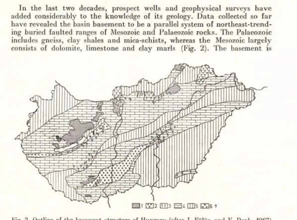
In th e la s t tw o decades, prospect wells an d geophysical surveys h a v e added considerably to th e know ledge of its geology. D a ta collected so f a r have revealed th e basin b a se m e n t to be a parallel system of n o rth e a s t-tre n d ing buried faulted ranges of Mesozoic an d Palaeozoic ro ck s. The Palaeozoic includes gneiss, clay shales a n d m ica-schists, whereas th e Mesozoic larg e ly consists of dolom ite, lim estone and clay m arls (Fig. 2). T he basem ent is
Fig. 2. Outline of the basement structure of Hungary (after J. Fülöp and V. Dank, 1967)
1 — Mesozoic, exposed; 2 — Palaeozoic (crystalline), exposed; 3 — volcanics, exposed; 4 — Mesozoic basin b a s e m en t; 5 — Palaeozoic basin basem ent; 6 — crystalline b asin b asem en t; ? — su p p o se d b a sin basem ent
ra th e r sh a tte re d , with b u ried horsts, sm all basins and d ee p furrows d issect
ing its surface. This fu n d a m e n tal relief of th e G reat P la in s formed for th e m ost p a rt a continental relief in the early T e rtia ry (Eocene, Oligocene, L ow er Miocene). The G reat P lains subsidence se t in in the la te T e rtia ry (from th e Middle Miocene onwards) a n d intensified in th e P annonian stag e. The process of basin evolution was in te rru p te d in b o th space and tim e. P a rts of the b asin
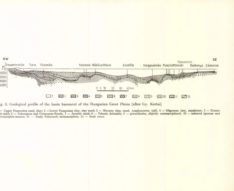
— th e areas along the U p p e r an d Middle Tisza — had a lre a d y begun to sink in th e U pper Cretaceous. T he la te T ertiary (m ostly Lower a n d Middle Pliocene) foundering of th e central p o rtio n of the b asin is proved b y P an n o n ian deposits directly overlying in places th e crystalline basem ent. T he r a te of subsidence m ay be inferred from th e thickness of th e clayey, m arly a n d sandy deposits of th e ra th e r shallow an d no n e too long-lived P annonian sea, which locally exceeds 3,000 m etres an d a tta in s 1,000 m etres over la rg e areas (Fig. 3).
In th e second half of th e Pliocene, th e uplifting of th e b a sin rim cu t off th e P an n o n ian sea from th e m ain body of th e M editerranean. At first, it was connected through th e p resent-day Iro n G ate w ith th e Black Sea, b u t subsequently it contracted to a shallow la k e sim ilar to th e Caspian S ea.
Fig. 3. Geological profile of the basin basement of the Hungarian Great Plains (after Gy. Kertai)
1 — U pper P annonian sand, clay; 2 —Lower P annonian clay, clay m arl; 3 — Miocene clay, sand, conglom erate, tu ff; 4 — Oligocene clay, sandstone; 5 — Eocene calc m arl; 6 — Palaeogene and Cretaceous flysch; 7 — Jurassic m arl; 8 — Triassic dolom ite; 9 — granodiorite, slig h tly m etam orphized; 10 — inferred igneous and m etam orphic masses; 11 — E a rly Palaeozoic m etam orphics; 12 — fa u lt zones
This w as then filled u p by increasing am ounts of w aste b ro u g h t in by the riv ers running off th e encircling m o u n ta in fram e. The subsidence of th e central p a r t of th e G reat P la in s basin also w e n t on, how ever, a fte r th e full disap
p ea ran c e of the P an n o n ian sea. In th e sub-basins, which subsided a t unequal ra te s , several h u n d re d m etres of flu v iatile an d subaerial se d im e n t came to be dep o sited over th e P annonian. T h e post-P an n o n ian sequence is thickest in th e southern G re a t Plains w here it is com posed largely of Q u a te rn ary san d s, clays and silts alm ost 1,000 m etres thick. O bservations indicate th a t th e G re a t Plains subsidence is still going on to d ay .
AH in all, the evolution of the G re a t H un g arian Plains falls in to two main c h a p te rs. In the first, th e relief was th e opposite of w hat it is to d a y . Instead of th e big basin, th e re were up to th e end of t h e Mesozoic block-faulted m o u n ta in s separated a n d dissected b y grabens. I t is in th e second chapter th a t th e basin of to d a y gradually cam e into existence, as a re s u lt of a subsi
dence t h a t had begun in the early T e rtia ry an d w ent on acceleratin g and covering more and m ore space th ro u g h o u t th e Ncogcnc. The la s t b ru sh strokes on th e picture were th e dissection b y th e Q u a te rn ary d rain ag e netw ork and th e a c tiv ity of th e w inds.
A llu v ia l fans higher than storm flood level
T he Pleistocene alluvial fa n of the D anube in the Great H u n g a ria n P lains T he alluvial fans of th e sm aller strea m s issuing from th e T ra n sd an u b ian hills in to th e G reat P lains, coalescing w ith th a t of th e D anube, to g e th e r con
s titu te th e divide betw een D anube a n d Tisza, which su rm o u n ts th e flood- plains of those rivers b y some 50 m e tre s. Most of this divide is covered with w ind-blow n sand dunes of n o rth w e st-so u th e ast tren d . A t th e end of th e P leistocene and in th e early H olocene, these were blown b y n o rth ea ste rly w inds o u t of the allu v ial fan of th e D an u b e. There still are som e sm all spots w here th e sand is m oving and th e w in d is producing fresh form s. However, th e u n b o u n d dunes w est of K ecskem ét an d in th e southern p a r t of th e divide re p re se n t only vague traces of earlier conditions.4
O n th e divide b etw een D anube a n d Tisza, th e re are, in a d d itio n to th e w ind-borne sand, som e loess zones of northw est-so u th east tre n d . There are th re e loess-covered m icroregions:
(a ) th e loessy hills of G ödöllő-M onor east of B udapest (6.24) (b ) th e flat loess rises betw een K ecskem ét an d Nagykőrös (1-23)
(c ) th e loess rise of th e Bácska (2.42) th e southernm ost p o rtio n of the divide.
T h e portion reaching into th e o u ts k irts of B udapest of th e d iv id e betw een D a n u b e an d Tisza is called the P e s t P lain. In this m icroregion, even the
4 Early in the last century, most of the dunes were covered by grassland that was at best good for grazing. Since then, however, the rolling sands have been stabilized by afforestation, and by the planting of orchards and vineyards. This activity has resulted in the formation of a layer of rich topsoil on the sands. On the divide between Danube and Tisza, between the longitudinal and parabolic dunes, there are wet and waterlogged areas. These undrained hollows once contained alkali lakes, drained since by a complicated system of ditches.
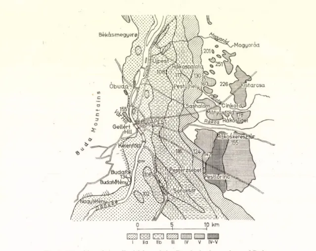
o ld er Pleistocene a llu v ia l-fa n terrace s of the D a n u b e are uncovered. The m o st elevated a n d o ld e s t of th em is th e G ünz-pre-G ünz gravel fan. In th e P e s t P lain, there a re — n o t counting th e floodplain surface of th e D anube — fo u r m ore Pleistocene alluvial-fan te rra c e s (Fig. 4), pro v in g th a t on th e b o r
d e r of th e G reat P la in s th e fo rm a tio n of th e g ra v e lly alluvial fans of th e D a n u b e was a c o n tin u o u s process fro m th e early P leistocene (Pécsi, 1959).
r~- -1 EJD
I II a lib IV-V
Fig. 4. Disposition of the alluvial fans of the Danube in the environs of Budapest
I — H olocene floodplain; I l a — L a te U pper P leistocene terrace (W ürm ); l i b — E a rly Upper Pleistocene terrace (R iss-W ürm ); III — Middle P leisto cen e terrace (R iss?); IV — E arly P le isto c en e terrace (Mindéi); V — Lower P leisto cen e terrace (G ünz-pre-G ünz); IV—V — T errace IV overlain b y T errace V
M orphologically t h e Mezőföld (1.3) is p art of th e G reat P lains. I t con
sists of older, Middle a n d Upper P leistocene alluvial-fan zones of southeasterly tr e n d w ith loess rises in te rc a la te d b etw e en them . B o th ty p e s overlie P ann o n ian c la y an d sand, ex p o se d in the ste e p bluffs looking down on th e D anube, to g e th e r with th e o v e rly in g loess w hose thickness a tta in s 60 m locally (Fig. 5).
14
The n o rth e rn b o rder of th e G reat P lain s is a string of alluvial cones form ed in th e Pleistocene by sm aller stream s. I n th e Holocene, th e continued subsi
dence of th e G reat P lains resulted in th e dissection of th is connected alluvial- fan slope into interfluvial ridges. On th e o th er hand, its low er p o rtio n in th e N agykunság (1.9) was c u t off by th e Holocene floodplain of th e Tisza from its ro o t region.
On th e sunny, so u th erly slopes of th e N orth G re at Plains allu v ial fan, th ere grow some of th e m ost ty p ical exam ples of th e excellent fru its and grapes of H ungary. C onditions m ost favourable to w ine growing ex ist in th e
vicinity of Gyöngyös a n d Eger.
Alluvial-fan plain of the Northern Great Plains (1.6)
A lluvial fa n o f the N yírség (1.7)
The N yírség is a large Pleistocene alluvial fan su rm o u n tin g t h e th ird floodplain horizon in th e N o rth eastern G re at Plains. I ts relief in m a n y w ays resem bles th e alluvial-fan plain of th e D anube. I t w as deposited b y rivers belonging to th e drainage system s of th e T isza-S zam o s-K raszn a on th e one h a n d , an d of th e B odrog on th e o th e r (Z. B orsy, 1961). This reg io n was slightly u plifted ag a in st its surroundings in the early Holocene — or, in o ther w ords, its en vironm ent h ad subsided — and consequently it w as b y passed b y all th e rivers which form erly trav ersed it. The fluviatile deposits of th e alluvial fan are overlain in th e eastern, m ore extensive p a r t of th e region b y a thick cover of w ind-blow n sand. This san d cover has th e highest rise of th e Nyírség (and of th e entire G re at Plains), an d reaches 186 m a.s.l. The central p a r t of th e N yírség is likewise covered w ith w ind-blow n san d , b u t th e surface is lower th ere an d is dissected b y a nu m b er of small n o rth s o u th tren d in g valleys betw een strings of dunes. In th e W estern Nyírség, th e dunes are covered w ith a th in cloak of loess, gradually thickening to w a rd s th e west. This cloak form s a tra n sitio n to w ard s th e H a jd u h á t (1,8), to th e w est of th e Nyírség, w hich is entirely covered b y a continuous b lan k et of loess.
The N yírség of to d ay is separated in to tw o parts b y a roughly east-w esterly divide from which th e parallel stream s betw een th e strings of dunes ru n on the one h a n d to th e n o rth into th e Tisza, and on th e o th e r to th e s o u th into the B e re tty ó . B etw een these strings of dunes th ere are also here depressions with poor drainage, som e of which co n tain peat bogs. The w ind-borne sand of th e N yírség was m oved largely b y n o rth e rly winds. T he surface of th e sand has b een stabilized b y acacia woods, orchards, p la n ta tio n s of w orld-fam ous J o n a th a n apple-trees a n d b y th e c u ltiv a tio n of p o tato es and tobacco.
A lluvial fa n o f the M aros River (1.11)
S itu a te d in th e so u th eastern p a r t of th e G reat P lains, this surface of late P leistocene and early H olocene riv er-laid w aste h a rd ly rises above th e actu al floodplains of th e rivers. The m ain b o d y of th e alluvial fan consists of sand
a n d sandy g ra v e l, overlain by v e iy th in floodplain loess loam or sandy loam . I t s flat, m o n o to n o u s surface is diversified a t m o st by a few derelict oxbows o f th e rivers o n c e traversing it. Along th e m ean d ers and oxbows there are sm all patches of riv erb an k d u n es. Since th e sandy-gravelly deposits of th e alluvial fan a re close to the su rface, g ro u n d -w ater is high an d th e loess loam covering the a llu v ia has been ch anged into alk a li soils here a n d there. Most of th e soil cover belongs, how ever, to th e ex cellen t chernosem an d m eadow chernosem g ro u p s.
Floodplain regions
T he floodplain o f the Danube in the Great Plains (1.1)
From B u d a p e st to the s o u th e rn frontier, th e D anube is accom panied by a ban d of flo o d p la in 20 to 30 k m wide an d 200 km long, sh arp ly distinct m orphologically fro m the su rro u n d in g regions. B efore th e m iddle of th e last ce n tu ry , up to t h e in stitu tio n of large-scale riv e r conservancy w orks, this was continuous sw am p a n d m arsh. I ts m ost ty p ic a l landscape form s include ox bow s and riv e rb a n k dunes, sin g ly or in g ro u p s. Among th e tangled web of filled-up m e a n d e rs there are shallow isolated alk ali depressions of various sizes (Fig. 5). T h e oxbow s fa rth e r from th e a c tu a l D anube bed becam e sw am py in th e cool A tla n tic phase of th e Holocene, s u b sta n tia l am o u n ts of p ea t form ed in th e m . S in ce the in s titu tio n of riv er conservancy, th e depressions of th e Danube m ean d e rs and oxbow s have d ried u p alm ost everyw here, to g e th e r with th e form erly w aterlogged floo d p lain ; th e one-tim e “ w atery w o rld ” , the w e t m eadow s, h av e b ee n replaced b y ploughlands. P ro tected by m an-m ade levees, th e floodplain along th e D a n u b e bas undergone a rapid anthropogenic tra n sfo rm a tio n .
The floodplain alo n g the D a n u b e sep arated itself a t the end of th e P leisto
cene and during t h e Holocene from th e older Pleistocene alluvial fan of th e D an u b e and fro m th e Mezőföld. I ts incision w as probably triggered b y a som ew hat in te n se r subsidence of th e S outhern G re a t Plains. T he borderline betw een the D a n u b e floodplain a n d th e M ezőföld is p artic u la rly sharp, a s te e p valley fla n k 30 to 50 m high.
T he floodplain o f the Drava (1.4)
Connected b y t h e low hills of In n e r Somogy — a plains-type geom orpho- logical subregion — w ith the L ake B alato n depression, th e extensive and broad floodplain of th e D ra v a River joins th e D anube floodplain beyond th e frontier, in Yugoslavia. T h e low er section of th e D rava floodplain is accom panied by a b ro a d band of loess-covered low alluvial-fan p lain , which likew ise belongs to this region.
10
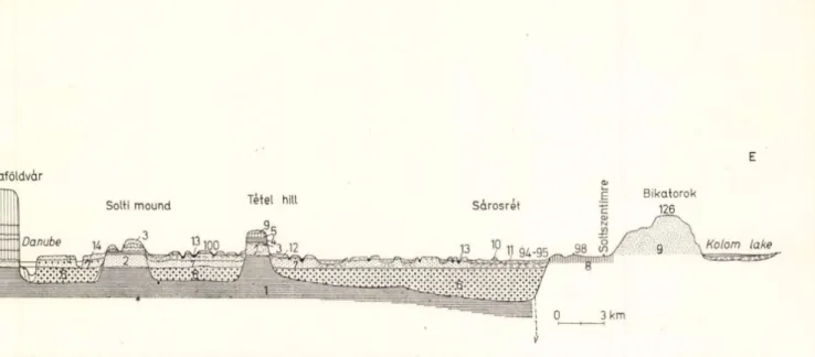
If
Fig. 5. Morphological profile of the floodplain of the Danube in the Great Plains (constructed by the author from data by M. Erdély and J. Siimeghy)
1 — P annonian clay; 2 — Pannonian sand; 3 — Pannonian sandstone overlain b y Pliocene red clay; 4 — red clay from th e Plio-Pleistocene b o u n d ary ; 5 — loess a t D unaföldvár, w ith th e fossil soil horizon 4-5; 6 — D anube gravel (late Pleistocene), w ith grain sizes dim inishing as distance from D anube increases; 7 — gravelly sand, sand, silty sand (Holocene); 8 — loessy sand; 9 — w ind-blow n sand; 10, 11, 12 — silty flood-laid sand, san d y flood-laid silt, yellow calcareous loess silt;
13 — m eadow clay, m uck; 14 — flood-laid sand
00 m a.s.l. NW SE
Fig. 6ab. Morphological profile of the middle Tisza section, ( a) Geological profile between Tiszaderzs and the hounds of Karcag.
(b) Geological profile between Perjéshát and Csorba-puszta (constructed by Z. Borsy on the basis of data from J. Siimeghy and his own surveys)
1 _ loessy sand; 2 — floodplain loesses, loessoid deposits; 3 — w ind-blow n sand; 4 — fine-grained river-laid sand; 5 — fine- and m edium -grained river- laid sand 6 — silt; 7 — san d y silt; 8 — clay; 9 — san d y clay; 10 — clayey sand; 11 — clay ey silt; 12 — silty clay; 13 — m eadow clay
The p a rt of th e Tisza F loodplain on H u n g a ria n te rrito ry falls into th re e geom orphological subregions.
(a ) The U p p er Tisza Floodplain, th e w ide Flolocene alluvial fan of th e Tisza and several of its trib u taries, reaching down to th e Tokaj G ate.
(b) The M iddle Tisza F loodplain, joined b y th e floodplain fan of th e Low er Zagyva, a n d broadening into the Jász sá g grassland. T he Tisza m odel
led th is section in th e Holocene, along a s tru c tu ra l graben; cu ttin g off th e so u th e rn p a rt of th e N orth G re at Plains fans, th e Tisza joined it to th e rim of th e N a g y k u n sá g -H o rto b á g y grassland.
(c) The Low er Tisza F loodplain, th e b ro a d floodplain v alley of th e Tisza betw een Szolnok an d Szeged, ra th e r deeper th a n th e regions flanking it on either side, a reflection on th e surface of th e so-called Tisza Trench of th e basem ent.
E xcept for th is la st section, th e Tisza v alley in th e G re at Plains is less w ell-defined th a n th e D anube valley. P rior to conservancy, th e Tisza roam ed o ver a v a st area an d , in flood tim es, stepping o u t of its bed, tran sfo rm ed its floodplain in to som ething of a sm all sea. D epositing huge am ounts of silt, m ud and san d , it g rad u ally filled up an d elev ated its floodplain (Fig. 6).
A fter th e floods h a d ru n down, there rem ained m any w aterlogged areas in th e deeper p a rts of th e floodplain, which held m arshes, sw am p-forests, p ea t hogs, willow an d po p lar groves lending a colourful aspect to th is p a rt of th e countryside.
The “ u n d u lo u s” Tisza o ften changed its bed, too. In th e la te s t P leisto
cene it still flowed south of th e Nyírség, along th e p re sen t B erettyó—ér to w ard s th e in te rio r of th e G re at Plains. I t w as only in post-glacial tim es t h a t it m ade th e d eto u r a b o u t th e Nyírség. E m erging from th e Tokaj G ate, d u rin g th e Flolocene it som etim es sought its course tow ards th e south, across th e H ortobágy p u szta. Its course is indicated to d a y by th e H ortobágy-ér.
(The H ortobágy p u szta, alm ost as flat as a ta b le , is largely covered by alkali soil types; this is w hy it is so forbidding.) A fter riv er conservancy, m ost of th e cut-off oxbow s filled u p q u ite rap id ly ; th e alluvia of th e low er-lying a n d w e tter p a rts of th e alluvial plain were occupied by hayfields, m eadow s a n d p asturelands. The loam y steppe and m eadow soils of th e higher alluvial plain surfaces w ere tu rn e d in to ploughlands. S o u th of th e M iddle Tisza Flood- plain th ere is an alm ost u n in te rru p te d strin g of riverbank dunes dissected b y m ajestic arcs of isolated oxbows. These belong to th e N a g y k u n sá g -H o rto b á g y grassland, a n isolated geom orphological region.
The floodplain of the Tisza (1.5)
P lain along the Berettyó and the Körös Rivers (1.10)
There is a v a s t w edge-shaped alluvial p lain p en e tratin g in to th e in terio r of th e G reat P lains along th e B erettyó an d th e Triple Körös. I t is in effect a system of coalesced alluvial fans, whose b ase is m ostly sand, covered w ith river-laid silt. A m ong th e alluvial fans deposited by th e roam ing riv er branches, deeper-lying sw am ps an d morasses developed. P rio r to river conser-
v an cy w orks, th e flood-laid silty w a ste of th e m eandering stream s led to a grad u al elevation of th e riv er beds a n d b anks. These n a tu ra l levees enclosed sm all, basin-shaped, u n d ra in e d depressions. Filled w ith w a te r a t flood tim es, th e l a t t e r retained som e of th e w a te r in the form of sm all alkali an d salt lakes. In th e dry sum m er seasons, m ost of these used to ev ap o rate an d c o n tri
b u te to alkali soil fo rm atio n . M assive riv e r conservancy works have also been carried o u t here: th e one-tim e sw am ps are ploughlands and p astu re s to d a y an d th e alkali lakes h a v e left th e ir tra c e s m erely as spots of alk ali soils or alkali ty p e m eadow soils. These m icroform s to g eth er w ith th e an thropogenic p re -H u n g a ria n tu m u li occur in alm o st all geom orphological regions ea st of th e T isza as accessory landscape elem ents.
T he allu v ial fans b o rd e rin g th e G re a t Plains an d reaching deep in to it carry h u g e volumes of ground an d fo rm a tio n w ater. In them , p a rtic u la rly along th e floodplains, subsurface w a te r currents come to exist a fte r th e snow m elt a n d after th e spring and e a rly sum m er rain s. In th e long d ry su m m er m o n th s, on th e o th e r han d , th e re is a m arked shortage of w a te r. I t is so m eth in g of a p arad o x , b u t nonetheless tru e, t h a t m ost of th e floodplains an d allu v ial-fan surfaces require irrig a tio n in th e d ry periods. T he w a te r needed fo r iri’igation is ta k e n p a rtly o u t of surface reservoirs co n stru c te d by d am m in g off th e rivers and p a rtly o u t of arte sia n wells sunk into th e su b su rface s tra ta contain in g fo rm a tio n w ater.
THE LITTLE PLAIN
S itu a te d in W estern H u n g ary , along th e D anube w here it enters th e C ar
p a th ia n basin and along one of its m ain trib u ta rie s, th e R ába, th e L ittle P lain c a n be subdivided m orphologically into a low floodplain-level alluvial fan a t its centre (2.1 in Fig. 1) an d a dissected older alluvial-fan p lain on th e basin b o rd e r (2.2, 2.3, 2.4). This la tt e r constitutes a passage to w ard s th e east in to th e foothill surface (glacis of erosion) of th e T ra n sd an u b ian M ountains an d tow ards th e w est in to th e sim ilar features of th e Alpine foothills.
T he evolution of th e L ittle P la in resem bles in m an y ways t h a t of th e G reat P la in s. Its m ost im p o rta n t s tru c tu ra l feature is th e R ába line, to th e west of w hich th e b a sin basem ent la rg e ly consists of crystalline schists, a c o n tin u a tio n of th e cry sta llin e core of th e E a st Alps. E a s t of th e R á b a line, th e b a s in basem ent is com posed of foundered fa u lt blocks of Mesozoic rocks, th e c o n tin u a tio n of th e T ra n sd a n u b ia n M ountains (Fig. 7). The subsidence of th e tw o different b ase m e n t u n its w as n o t uniform : th e Mesozoic blocks had b e g u n to sink earlier (in th e early T ertiary ), w hereas th e rapid subsidence of th e crystalline b ase m e n t began only la te in th e Miocene or Pliocene.
Hence, in th e w estern p a r t of th e basin , th e crystalline was still on th e surface in th e second half of th e Miocene. D eep drilling has proved th e subsidence of th is a re a to have ta k e n place d u rin g th e P an n o n ian transgression. This la tte r p roduced m ore th a n 1,000 m etres of sedim ent from a landlocked sea.
S ubsidence slowed dow n a t th e end of th e U pper P an n o n ian , an d flu v iatile a p p la n a tio n was intensified by th e u p liftin g of th e m ountain fram e. As a result, th e sea re tre a te d a t a fast ra te .
20
SSW
A N N E
(A) th ro u g h th e w estern L ittle Plain basin,
(B) th ro u g h th e L ittle P lain betw een th e L eitha and B örzsöny M ountains,
(C) b etw een Sopron an d P ápa. . . , .... . ..
I _ Pliocene a n d y o unger deposits; 2 — Miocene sed im en tary rocks: 3 volcanics; 4 — (Jligocene; o üocene;
G — Mesozoic; 7 — Palaeozoic
In th e U p p e r Pliocene, th e D anube a n d its trib u ta rie s, em erging onto th e L ittle P la in , deposited a g re at deal of sand unconform ably over th e P annonian deposits. T he stream s h ad firs t flowed so u th w a rd th ro u g h th e L ittle P lain, to w ard s th e p resen t-d ay D ra v a valley, a n d filled up th e L ittle Plain depression. This U pper Pliocene, A stia n filling ex te n d e d over th e e n tire
Fig. 8. Alluvial fans of the Danube iu the Little Plain (after M. Pécsi, 1964)
1 — rem n an ts of th e older alluvial-fan te rra c e (Aft) of th e D an u b e; 2 — supposed e x te n t of the old er allu v ial fan, formed fro m th e beginning of th e Pleistocene to th e e n d of th e Mindéi; 3 — e x te n t of th e yo u n g er alluvial fan (Af) of th e D a n u b e; 4 — lim it of th e yo u n g er allu v ial fa n , form ed from th e M indéi—Riss in terglacial to th e present; 5 — a llu v ia l fa n of th e R ába, R épce an d M arcal; 6 — m ou n tain fram e; 7 — lim it of terraces I l a , l i b and locally I I I b e tw ee n G yőr a n d K om árom
L ittle P lain are a , u p to th e feet of th e T ra n sd an u b ian M ountains, an d indeed also fa rth e r so u th an d southw est, onto th e T ra n sd an u b ian Hills.
This ex ten siv e san d y deposit, locally preserved in thicknesses up to 200 m , was according to some w orkers (E. S zádeczky-K ardoss, J . Siim eghy) a p ro d u c t not of th e A ncient D an u b e alone, b u t th e jo in t deposit of th e A lpine-C ar- p ath ian d rain ag e, p e n e tra tin g into th e a re a of th e o n e-tim e P an n o n ian sea (i.e. th e p ro d u c t of a fluviolacustrine sedim entation).
On th e w e ste rn an d e a ste rn m argins of th e L ittle P lain, a basaltic volcanism took place in th e U p p er P an n o n ian , a n d th e n also in th e U pper Pliocene an d Lower P leistocene. S im u ltan eo u sly th e T ra n sd an u b ian M ountains u n d erw en t an u p liftin g w hich d iv erte d th e D anube a n d its trib u ta rie s to th e east, to w ard s the V isegrád gorge. (In a m an n er not as y e t cleared in all detail, th e R á b a
22
sh ifted its alluvial fan to th e n o rth e a st, th e D anube to th e e a s t of th e sandy allu v ial fan deposited in th e U pper Pliocene.) In the V isegrád gorge, th e D anube presum ably used th e pre-existing Ip o ly -G aram v alley to break th ro u g h th e T ransd an u b ian M ountains w hich were still r a th e r low a t t h a t tim e. I t is since th e late Pliocene and th e beginning of th e Pleistocene t h a t th e terraces of th e D anube ca n be tra c e d in th e section across T ransdanubia an d through th e T ran sd an u b ian M ountains.
The forms dom inating th e p resent-day surface of the L ittle P lain include th e Pleistocene terraced allu v ial fans a n d floodplain-level w a ste fan plains of th e D anube, th e R ába a n d th e ir trib u ta rie s.
A lluvial fans o f the Danube (2.1, 2.4)
Young floodplain-level waste fa n plain. T he enormous a llu v ia l fan of th e D an u b e in th e L ittle P lain can be su b d iv id ed into tw o generatio n s. The younger, floodplain level fa n — whose m odelling is still c o n tin u in g to d ay — ex ten d s from B ratislava to K om árom fo r a distance of m ore th a n 100 k m a n d is 60 to 80 km wide. M ost of it is on Czechoslovak te rr ito r y (Fig. 8).
Ő 2 l 6 8 10 km Fig. 9. Morphological profile of the Little Plain fan of the Danube (after M. Pécsi, 1968)
I — m a in branches w ith alluvial b a n k s; I I — side b ran ch es, m eandering; H — H o locene gravel; rew orked Q u a te rn a ry alluvia; W — W ürm grav el w ith traces of c ry o tu rb a tio n ; R —W — g ra v e l of th e Riss and of th e Riss—W ürm in terglacial, w ith traces of s ev e ra l phases of c ry o tu rb a tio n
Its H u n g arian portion includes the S zigetköz (2.11), th e H a n sá g an d th e Moson Plain. (2.12). In th e ce n tral p a rts of th e latter, th e deposits of th e D a n u b e are 200 to 250 m th ic k . The s a n d y coarse gravels form a norm al stra tig ra p h ic sequence since th e Middle Pleistocene. The m ain bran ch of th e D a n u b e now flows along th e elevated axis of th e alluvial fa n a n d it is only on th e m argins of the fan t h a t th e U pper Pleistocene c ry o tu rb a te d gravels a re exposed on th e surface (Fig. 9).
Older alluvial plain. In A u stria, w est of th e L ittle P la in , th e P arn d o rf P la te a u is a re m n a n t of th e older alluvial-fan terrace of th e D anube. I t lies a b o u t 50 m etres above th e a c tu a l floodplain-level fan. U p to th e Middle Pleistocene, it was connected w ith th e alluvial-fan terraces of early P leisto
cene age s itu a te d east of G yőr, m ost of w hich form te rra c e islands to d ay (see Figs. 8 an d 10). At th e tim e when th is older fan was bein g formed, th e D anube en tered the L ittle P lain th ro u g h th e Bruck G a te on th e b o rd er of th e L eitha M ountain, r a th e r th a n a t D evin, through th e P orta Hungarica,
where it does to d ay . This fa n was deposited th ro u g h o u t a longer span of tim e , presum ably th e e n lire Low er Pleistocene, while th re e terraces were being incised in th e V isegrád gorge. On th e basis of its fossils, the alluvial-fan gravel was deposited in a h o rizo n tal as well as in a v e rtic a l sequence, d u r ing several phases of g laciatio n and deglaciation.
Fig. 10. Morphological profile across the Győr Basin (after M. Pécsi, 1958)
1 — Pannonian; 2 — U p p er Pliocene cross-bedded sand; 3 — older alluvial-fan g rav el; 4 —l argely g rav elly -san d y river-laid deposit fillin g th e G y ő r b asin ; I l a to V I — D an u b e terraces
Alluvial fa n o f the R ába a n d its tributaries (2.1, 2.2)
The R ábak ö z, th e floodplain-level w aste fan plain of th e R á b a (2.14), m erges into the low w aste plain of th e D anube. On th e o th e r h a n d , the older fan of the D an u b e m erges in to th e a c tu a l allu v ial fan te rra c e of th e R ába in th e K em eneshát region. H ow ever, th e A lpine trib u ta rie s of th e R ába have also developed a double allu v ial-fa n surface, a higher e a rly Pleistocene (2.21) an d a low er-terraced, y o u n g e r one (2.22). This la tte r is th e Sopron-V as g ravel sheet plain.
Marcal basin (2.3)
Sim ilarly to th e R á b a , th e M arcal an d its trib u ta rie s h a v e b ip artite allu v ial fans. The low er, y o u n g er P leistocene levels are m ore extensive; of th e o lder ones th ere re m a in ju s t a few re m n a n ts an d outliers. T he alluvial-fan plain of th e Marcal b a sin is, c o n tra ry to th e G yőr basin, a h alf-b asin of accum ulation an d d en u d a tio n , n o t one p u re ly of accum ulation. In th e E arly Pleistocene, th e R ába first eroded th e surface of th e M arcal basin , th e n deposited an alluvial fan on it. A fter th e subsidence of th e G yőr b asin , th e Marcal an d its trib u taries incised them selves even deeper an d rem oved a t least 100 to 150 metres of P a n n o n ia n san d a n d clay.
This lan d scap e includes — am ong its ty p ic a l form s — som e b asalt-capped m onadnocks, a few of w hich rise m ore th a n 100 m abo v e th e basin b o tto m . The b asalt lav as of th e U p p er Pliocene h a v e preserved som e rem nants of th e ancient relief.
THE HILLY REGIONS OF TRANSDANUBIA
To th e so u th and w est of Lake B alato n , dow n to the b ro a d alluvial plain of th e Mura an d D rava th e re is a rolling surface com posed of several m ore or less independent regions, com prehensively called the H ills of T ra n sd an u b ia.
Geologically it is a T ransd an u h ian a p p e n d ix of the P a n n o n ia n basin. iLs basem ent is an altern atio n of zones of Palaeozoic crystalline and Mesozoic sedim entary rocks, more or less parallel to L ake B alaton. Som e of it is v ery deep (more th a n 4,000 m b e n e a th th e hills of W estern Z ala). I t is overlain b y a m arine T ertiary, largely P an n o n ian , in thicknesses usually ranging from 500 to 2,000 m. M ostly know n from drill cores, som e of these deposits crop out also on th e flanks of th e deeper valleys. In c o n tra s t to th e G re a t an d L ittle P lains, T ran sd an u b ia had risen ra th e r th a n subsided a fte r th e re tre a t of th e P annonian sea; this resulted in a more intense dissection of th e landscape an d in th e hilly modelling of its surface. In th e T ran sd an u h ian hills, ju st as in th e L ittle P lain, th e P a n n o n ia n is overlain b y 100 to 200 m etres of cross-stratified fluviatile-lacustrine sed im en t, m ostly san d , overlain in its tu rn by a gravel sheet sp read b y th e R á b a a n d Mura, th e stream s em erging from th e Alps, in th e la te Pliocene and e a rly Pleistocene. T he flat surface of th a t tim e w as th e initial plane of th e v alley modelling t h a t set in in th e Pleistocene. The T ra n sd an u h ian hills, u p lifte d in th e course of th e Q u a te rn a ry , were thoro u g h ly dissected b y stream s ru n n in g tow ards th e Z ala -B alato n drainage system on th e one h a n d , and to w ard s th e floodplains of th e D anube an d D rava, on th e other. In th e process, th e U pper Pliocene, A stian cross- stra tifie d san d becam e intensely worn dow n. In the valleys, fluviatile sand a n d gravel cam e to be deposited during th e Q uatern ary , w hile th e slopes grew a th ick cover of loess. In th e w e ste rn p a rt of th e Zala region, th e re form ed, in stead of th e ty p ic a l loess, a b ro w n earth or lo am on th e m ore m oisture-rich forest-covered hilltops.
S outh of th e W estern B a la to n basin, in In n e r Somogy, fluviatile a c tiv ity was d o m inant up to th e end of th e P leistocene. In the e a rly Holocene, an d to some e x te n t also a t th e end of th e P leistocene, the w ind blew dunes o u t of these fluviatile sands. This region is consequently of a plains ra th e r th a n a hilly ch aracter.
T h e hills of U pper Vas and Zala (4.1)
S outh of th is terraced fan situ ated am ong th e valleys of th e B ába, M ura an d Lower Zala, an d of th e U pper Zala V alley, respectively, th e valleys an d th e broad in terflu v ial rises acquire a so u th e rly trend. I t is p articu larly in th e eastern p a r t of th e Zala region th a t so-called “ m eridional valleys” are typical. These valleys dissect th e region in to flat-topped parallel (m eridi
onal) rises of fairly uniform h eig h t (200 to 300 m etres). This p ecu liar m orphol
ogy elicited several hypotheses from w orkers in the region. Som e contended th a t th ey w ere due to flu v iatile erosion alo n g stru ctu ral lines. O thers m a in ta in e d them to be of a d eflationary origin, w ith the rises betw een th em representing y ardangs. I t is, however, d ifficu lt to prove th e n o rth erly w inds necessary to m odel such form s. The v alley flanks are covered w ith a th ick
cloak of s tra tifie d loam y loess of deluvial a n d solifluidal origin. Locally th is cloak reaches dow n b e n e a th th e a c tu a l s tra th s, th u s proving th a t m ass w asting also play ed a p a r t in m odelling th e valley flanks. E a rly in th e H o lo cene, on th e o th e r h a n d , th e poorly d ra in e d stra th s h eld swamps and p e a t bogs, (see: G eom orphological Map of H u n g a ry ).
Somogy H ills (4.3)
This region, situ a te d so u th of Lake B a la to n , resem bles th e preceding one in m any re sp ects, b u t its m eridional v alley system is in te rru p te d by y o u n g er and more sh a rp ly defined valleys p erp en d icu lar to th e m eridional set. T he relief thus h as a checkerboard-like asp e ct. The east-w esterly valleys a re ra th e r asy m m etric an d step p ed . The n o rth flanks are steep , th e south flan k s gentle an d covered w ith a th ic k slope loess dissected b y b ro a d flat derasional valleys. T he highest in terflu v ial rises h a d once (in th e U pper Pliocene a n d Lower P leistocene) been th e gently sloping piedm ont (glacis of erosion) of the T ra n sd an u b ian M ountains. I t was only during th e Middle and U p p e r Pleistocene, co n c u rre n tly w ith th e fo rm a tio n of th e B a la to n depression an d th e valleys p arallel to it t h a t th e y were dissected by s tru c tu ra l and erosional processes.
The Lake Balaton depression (4.2)
The b ro a d depression of n o rth e a st-so u th w e st tre n d of Lake B alato n is in effect a b a sin betw een th e T ra n sd an u b ian M ountains and the S om ogy hills. I t is a g ra b e n depression form ed by re p e a te d subsidence. Its southw estern p art presu m ab ly assum ed its p resent form as early as th e Lower Pleistocene, whereas th e re s t did so only la te in th e Pleistocene. The so u th shore of L a k e B alaton is lin ed w ith lakeshore dunes a n d sand bars. T hese separate from th e m ain b o d y of th e lake u n d rain ed b asin s which tu rn e d into peat bogs in the H olocene.
The Mecsek a n d the Tolna—B aranya H ills (4.4)
The T olna—B ara n y a Hills (4.44) lie so u th of th e K apos River v alley . To the s o u th th e y pass alm o st im p ercep tib ly into th e h o rst-ty p e m o u n ta in island of th e Mecsek (4.41). The la tte r, how ever, looks dow n with a steep , stepped slope onto th e Pécs P lain in its foreland. C onstitu tin g a so u th e rn cornerstone of this region, th e re is n e a r th e frontier th e sm all Villány hill group, likew ise consisting of Mesozoic lim estones. B etw een th e two M esozoic ranges, ad jo in in g th e so u th e rn foothill of th e Mecsek, th e Mórágy block (4.422) is a g ra n ite m ass, an elem ent of th e crystalline basem ent.
The Mecsek is a locally folded and universally fa u lte d m ountain of s o u th w est-northeast strik e. The V illány group (4.423), of a sim ilar structure, h as on th e co n trary a w est-east tre n d an d an im b ricated stru ctu re . T he sub- and m icro
regions lying w est and north of th e Mecsek of the T o ln a -B a ra n y a region arc intensely dissected low p latea u x , consisting of P an n o n ian clays an d sands wearing a th ic k loess b la n k e t. B eneath th e loess there is locally a ra th e r thick bed of P leistocene river-laid sands.
The crystalline m assif co n stitu tin g th e b ase m e n t of T ra n sd an u b ia u n d e r
w ent a process of shatterin g a n d w earing dow n in the la te Palaeozoic. In th e Mecsek area of today a b asin depression h ad formed on its surface.
This was in u n d a te d by the sea which th en deposited a large a m o u n t of sand a n d gravel r a th e r rich in ra d io a ctiv e su bstances, eroded from th e encircling crystalline hills. The red an d varicoloured sandstones form ed in this w ay occupy a large a re a in the W e ste rn Mecsek. T hey are of P erm ian age. In th e m eantim e, th e m arine trough fu rth e r deepened eastw ard, off a zig-zagging crystalline shoreline, and a Liassic sequence of a to ta l thickness of some 800 m etres, containing several coal seams, came to be deposited in slowly subsid
ing shallow em b ay m en ts of th e sea. The w e ste rn p a rt of th e m ountains h ad alre ad y been la id d ry by th a t tim e. By th e en d of the Mesozoic, th e en tire Mecsek em erged as a dry lan d , b u t it was o n ly m uch la te r t h a t it detached itself m orphologically from th e crystalline areas surrounding it. Up to th e U pper C retaceous, th e Mecsek, m ore ex ten siv e th a n to d a y , was plan ated u n d e r a tropical clim ate. This process m ay h av e resulted in la te ritiz a tio n an d b au x itizatio n , as proved b y th e b a u x ite deposit in th e V illány Hills.
In th e Upper C retaceous, a liv ely volcanism to o k place sim ultaneously w ith th e folding of th e C arpathian fram e. Of th e doleritic eru p tio n s there are to d a y ju st a few rem nants an d necks left. I n th e late T e rtia ry , th e Mecsek
Fig. 11. Morphological profile of the planated surface in the Mecsek Mountains foreland
T — rem nants of U p p e r Cretaceous tro p ical peneplain; P x — U p p e r Pliocene pied m o n t surface, dissected, and rem odelled in the P leistocene; P 2— rem nants of a Lower P an n o n ian b ench of abrasion; P 3— re m n a n ts o f H elvetian b ench of abrasion; P — Pleistocene gl <cis p ie d m o n t surface; SM — subm ontane basin. 1 — Paleozoic g ran ite;
2 — Ju rassic lim estone; 3 — H elvetian, T o rto n ia n beds; 4 — P lio cen e (Pannonian) b ed s; 5 — slope loess
Block and its surroundings definitely d etached them selves from th e su rro u n d ing Palaeozoic crystalline m asses an d the fo o t of th e Mecsek w as repeatedly in u n d ated by th e sea. The b orders of the in su lar m ountain m ass were covered w ith m arine d eposits and in th e shore zones benches of ab rasio n still dis
tin c tly visible to d a y came to ex ist. After th e re tre a t of th e P an n o n ian sea, a long gentle foothill surface — a glacis of erosion — developed in th e so u th ern foreland of the Mecsek. S culptured in little consolidated m arine
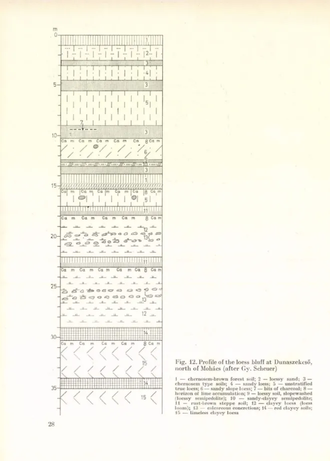
Fig. 12. Profile of the loess bluff at Dunaszekeső, north of Mohács (after Gy. Scheuer)
I — chernosem -brow n fo re s t soil; 2 — loessy san d ; 3 — chernosem ty p e soils; 4 — san d y loess; 5 — u n stra tifie d tr u e loess; 6 — san d y slope loess; 7 — bits of ch arco al; 8 — h o rizo n of lim e accu m u latio n ; 9 — loessy soil, slopew ashed (loessy semipedolite); 10 — sandy-clayey sem ipedolite;
I I — rust-brow n s te p p e soil; 12 — clay ey lo ess (loess lo a m ); 13 — calcareous concretions; 14 — red c la y e y soils;
15 — lim eless clayey loess
28
deposits, it reached dow n to the V illány Hills (Fig. 11). The piedm ont surface, fu rth e r elevated d u rin g th e Pleistocene, was dissected b y th e stream s flowing- dow n from the ce n tral mass into b ro a d in terstre am rises. The n o rth e rn and so u th ern foreland of th e Mecsek becam e two d istinct h illy regions. T he m oun
tainous area degraded to a hilly ty p e landscape surrounding th e Mecsek u nderw ent several cycles of valley incision and la te ra l erosion, slope deposit and loess form ation. T he blan k et of loess and loessoid slope deposits, 20 to 50 m thick, is subd iv id ed by several fossil soil horizons, as m any as six in some places. Of th ese, th e older (and deeper-lying) ones are u su ally red clayey soils which reflect a considerable M editerranean clim atic influence (Fig. 12).
THE TRANSDANUBIAN MOUNTAINS Regional subdivision
T he individual block-faulted h ö rst units of th e T ran sd an u b ian M ountains are separated by sm allish basins a n d grabens of n o rth w e st-so u th e ast strike, perpendicular to th e m ain tren d of th e m ountains. The largest single unit is th e Balcony, s itu a te d north of L ake B alaton (Fig. 1, 5.1), an d delim ited a g a in st th e Vértes (Fig. 1, 5.3) by th e Mór graben. F a rth e r east a n d north th e re are the fau lt blocks and in terc alated basins of th e B uda-P ilis-G erecse group (Fig. 1, 5.4). I t is to this la tte r group th a t we h av e joined th e volcanic range of the D unazug (“ D anube n o o k ” ), although in form s and co n stitu tio n it differs from th e m . The conspicuous valley gorge of th e D anube divides th e D unazug u n it m ore sharply from th e In tra -C a rp a th ia n volcanic girdle th a n th e y are co n n ected by m orphological sim ilarities.
Structural and morphological evolution
T he Lit tle Plain a n d G reat Plains basins are se p a ra te d by the T ransdanubian M ountains. This ra n g e has, ju st like th e Mecsek m ountains, a crystalline b asem ent. The long m arine tro u g h of n o rth ea st-so u th w est tre n d t h a t devel
oped late in th e Palaeozoic was m ainly filled w ith a sequence of Triassic lim estones and dolom ites, of more o r less pronounced S outh A lpine affinities.
Most of this tro u g h was laid dry a t th e end of th e Triassic, b u t its n o rth ern side was in u n d ated b y th e Ju ra ssic an d Cretaceous an d th en also b y the T e rtia ry seas. Along th e m ountain axis, th e in d iv id u al stru c tu ra l u n its per
form ed a com plicated ballet of subsidences and u p liftin g s irregular in space an d tim e.
In th e Cretaceous, however, th e surface of th e m o u n tain s was still ra th e r uniform . Under a tro p ic a l clim ate it was d ep lan ated to a low b u t extensive peneplain. This is p ro v ed by th e bauxites and la te rite s w idespread in the m ountains. From th e U pper Cretaceous onw ards, in th e phases of orogeny th a t resulted in th e folding up of th e C arpathians, th e T ra n sd an u b ian Moun
tain s underw ent block-faulting w ith th e developm ent of graben subsidences an d h o rst-ty p e k a r s te d hills. In th e T ertiary, th e blocks uplifted to various
COo
NW
Rába river Tét -1 Tét-2 Bakonytamási Csesznek Dudar Gaja Öregfutoné
cp t mb p2
SE Berhida Füle
9
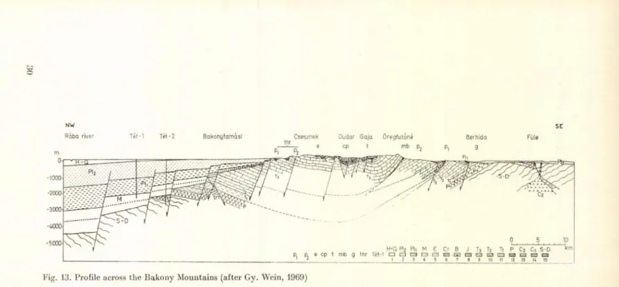
Fig. 13. Profile across the Bakony Mountains (after Gy. Wein, 1969)
1 — H olocene-Pleistocene river-laid sand a n d gravel and flood-laid soils; 2 — U pper Pannonian sand and clay; 3 — Lower P annonian (Pliocene) clay m arls; 4 — Miocene gravels and sand (in th e D udar basin, including th e U pper Oligocene); 5 — Eocene coal scam s and carbonatic rocks; 6 — Lower Cretaceous (A ptian-A lbian- Cenomanian) lim estones and calcareous m arls; 7 — b a u x ite and related form ations; 8 — Jurassic lim estones; 9 — U pper Triassic dolom ites and lim estones; 10 — Middle Triassic lim estone; 11 — Lower Triassic aleurolite, m arl and lim estone; 12 — P erm ian sandstones and conglom erates; 13 — U pper Carboniferous gran ite p ro p h y ry ; 14 — Lower Carboniferous conglom erate and clay shales; 15 — Silurian-D evonian p h y llite an d crystalline lim estone; t — u p lifted re m n a n t of tropical peneplain;
cp — cry ptoplane; e — exhum ed peneplain, locally covered w ith a Miocene gravel sheet; m b — m ountain-border bench; p 2 — P annonian bench of abrasion; p 1 — p iedm ont surface (pedim ent); g — Pleistocene p iedm ont surface m odelled in little consolidated sedim ent (glacis); th r — rem odelled tropical peneplain in threshold position; Tét—1—2 — prospect wells