E COCYCLES Open access scientific journal ISSN 2416-2140 of the European Ecocycles Society
Ecocycles, Vol. 6, No. 1, pp. 88-97 (2019)
DOI: 10.19040/ecocycles.v6i1.165
ORIGINAL ARTICLE
Lake Balaton hydrology and climate change
Károly Kutics
aand Gabriella Kravinszkaja
ba R&D Consulting Environmental Services Ltd., Veszprém, Rózsa u. 46., H-8200 Hungary
b Central Trans-Danubian Water Management Directorate, Székesfehérvár, Balaton u. 6., H-8000 Hungary E-mail address: kutics.karoly@chello.hu
Abstract – Situated in the western part of Hungary, Lake Balaton is the second largest shallow lake in the European Union after Lake Peipus and the largest one laying entirely within the borders of the EU. Despite of its large surface area of some 600 km2, its average depth is only 352 cm. Lake Balaton is an exorheic lake on multiannual basis, but dry spells in the last 2 decades resulted in a 64-month period without outflow. Studies by the authors and others proved that human impacts of global and local nature resulted in the significant decrease of the natural water balance (NWB) in the last 3-4 decades. Climate change is already manifested in the reduction of the discharge of most of the tributaries including the largest one, Zala river. The statistically significant decrease in the last 3 decades of the discharge of Zala river and Kiskomáromi-canal corresponds to a deficit of 67 lake mm/year. The impact of further human interventions including reconstruction of Balaton Minor, a vast wetland and mining resulted in a further deficit of 119 to 154 lake mm/year. The average of the annual NWB of the last 30 years is only 63% of the long-term average. In addition to the decrease in the average discharges and NWB, variability of these values increased considerably. Some of these phenomena can be attributed to climate change. Future impacts of climate change are evaluated and it is concluded that the Lake Balaton watershed may turn into an endorheic basin in the second half of the 21st century.
Keywords – Lake Balaton, human impact, climate change, water balance, future trends Received: April 15, 2020 Accepted: May 20, 2020
INTRODUCTION
Lake Balaton is the largest lake in Central-Europe with a 605 km2 surface area. It is one of the most important lakes in Europe in terms of ecological, economic and cultural significance. Its whole watershed of 5,775 km2 is part of the planned Balaton Ecomuseum (Némethy, 2019) area extending to as much as 8,500 km2.
The lake is a relatively young surface water body since its formation began some 20,000 years ago with a few independent lakes that eventually merged into one large lake about 5,000 years ago with a maximum water surface of ca.
1,200 km2. The depth of the lake changed wildly in the last 2,000 years, with water level elevations from 103 to 113 m over Adriatic Sea level (Bendefy, 1968, 1969). Up to the beginning of the 19th century, the lake and its surrounding marshlands were rather a burden than a blessing for the people inhabiting the area since occasional flooding of the lake damaged crops and made transportation around the lake difficult, if not impossible. Perhaps the only benefit of the lake in the 16th and 17th centuries was that its extremely high water level and the flooded marshlands hindered the advance of Turkish occupation and provided refuge for the Hungarian
population. After the Turkish were driven out of the country at the end of the 17th century, the tributaries and the outflow (Sió river) were utilized as hydropower for water mills.
However, the mill dams along the Sió river resulted in higher water levels both in Lake Balaton and the marshlands making the agricultural utilization of land and transportation of agricultural goods very difficult. The situation was recognized as a problem in the middle of the 18th century, and the onset of a series of the numerous human interventions in the Lake Balaton environment can be dated to this period.
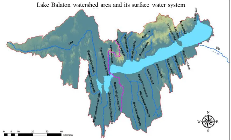
The present-day size and form of the lake can be dated back to the 1860s, when level control was introduced in order to protect the newly built railway along the southern shore. A sluice was built in 1863 with 17-18 m3/s maximum discharge capacity that was re-built in several steps to reach the present day 80 m3/s nominal (ca. 55 m3/s practical) capacity. The present-day Lake Balaton and its watershed and its sub- watersheds are shown in Figure 1. and Table 1.
© 2020 The Author(s). Ecocycles © European Ecocycles Society, ISSN 2416-2140 Volume 6, Issue 1 (2020)
89
Figure 1. The Lake Balaton Watershed and its sub-watersheds Table 1. Sub-watersheds of Lake Balaton
Main characteristics of the watershed
The area of the watershed is 5774.5 km2 of which the lake area is 605 km2 (at 100 cm gauge level)* therefore the land area of the watershed is 8.54 times larger than that of the lake.
The watershed is located in a hilly area, with the highest point being 600 m aBs†, and about 495 m above the water surface of the lake. The lake volume is 2.13 km3 and its average depth
*Area of the lake changes with water level. While in the past the annual mean lake level was around 75 cm gauge with the corresponding lake area of 588.5 km2, in recent years, due to a changed water management policy, it is kept higher around 100 cm resulting in a lake area of 605 km2.
†a.B.s.: Above Baltic Sea level (at Kronstadt)
is 3.52 m. The lake is extremely shallow, its dynamic ratio‡ (Håkanson, 1983, Bachmann et al., 2000) is 7.0.
Hydrology and water balance of Lake Balaton Water balance of the lake
The annual natural water balance of the lake is calculated as follows:
‡Dynamic Ratio = square root (area, km2)/(mean depth, m). If DR>2 for a lake, it is definitely shallow, i.e. the lake sediment is frequently resuspended by wind induced waves and thermal stratification does not occur.
Name of sub-watershed Area (km2) Characteristics
Zala River (Western) 2622 Hilly with several tributaries
Balaton Uplands (Northern) 820 Steep terrain, short watercourses
Somogy Hills (Southern) 1272 Hilly with extensive marshlands
Mezőföld (Eastern) 36 Very small, plain
Direct (not belonging to water courses) 420 Direct runoff from lakeside communities
Lake surface 605 Precipitation < Evaporation
Watershed total 5775
90
Natural water balance (NWB) = (Direct precipitation to the lake) + (Inflow from the watershed) ̶ (Evaporation from the lake surface). The practical water balance of the lake includes withdrawal and outflow as well both items being controlled
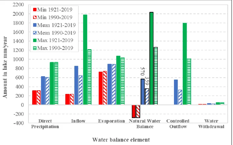
by the Central Transdanubian Water Management Directorate. Water withdrawal (for drinking water and irrigation purposes) has been almost negligible in the last 100 years, only 1-3 % of the intake side of the water balance. The Figure 2. Extreme values and averages of the elements of the water balance of Lake Balaton for two periods
Figure 3. Annual NWB of Lake Balaton (red line: 99-year average; green dashed line: linear regression)
© 2020 The Author(s). Ecocycles © European Ecocycles Society, ISSN 2416-2140 Volume 6, Issue 1 (2020)
91
controlled outflow was almost equal to direct precipitation in the 20th century, but it shows a declining trend in the last few decades.
In recent years, as countermeasure of occasional draughts and water quality control considerations, the water level is kept high. The maximum control level was increased in three steps from 100 cm gauge level to 120 ± 6 cm the latter being in effect since 2018. Increasing the maximum water level by 20 cm means about 120 million m3 more water stored in the lake, but the measure is controversial since it is considered premature since shore protection structures were not reinforced and/or elevated beforehand resulting in occasional damages in shoreline structures and real estate.
Reliable annual water balance of the lake has been calculated since 1921, following the construction of a new sluice at the outflow. Elements of the water balance of the lake in terms of minimum, mean and maximum values for the 1921-2019 as well as for the last 30 years are shown in Fig. 2. As far as precipitation is concerned, it is obvious, that there is negligible difference in precipitation for the two periods shown, but it is remarkable that both the absolute minimum and maximum values occurred in the last 3 decades. Inflow minimums occurred in the last 3 decades, and both mean and maximum values are much smaller for this period than for the whole time series. Differences in evaporation are not significant. However, the minimum value of the natural water balance (NWB) occurred in the last 30 years and the corresponding mean value (359 lake mm/year) is a mere 63%
of the value (570 lake mm/year) for the whole period. This is a quite alarming sign that need to be further analysed later on.
In accordance with the decrease in the NWB, the outflow also decreased significantly and as many as 4 years occurred in the last 3 decades with zero and two more with practically zero value (1 lake mm/year). The annual NWBs for the whole 99- year long period are shown in Fig.3., together with the average value (red line) and the linear trend line (green dashed). The regression equation shown is significant at p = 0.013 level. It can be concluded that the natural water balance is decreasing. The first negative NWB was experienced in year 2000 and occurred 7 times in the last two decades.
Trends in tributary discharge
Kutics et al. (2016) analysed the time series of daily discharge data of 26 monitoring points on 21 water courses. Length of the time series differed from one point to another the shortest being 12 years and the longest being 63 years. The average
length was 32.1 years. Minimum, mean and maximum daily discharges for the summer and winter half years as well for the whole year were determined. Linear trend equations of all type of data for each monitoring point were determined, and statistical significance of correlation was analysed by Pearson’s test. Numbers of negative and positive discharge trends were calculated and are shown in the first two data lines of Table 2. Negative trends dominate, and out of the analysed cases, 73.1 % showed negative trends. Pearson’s test was performed for the correlation coefficients of the trend equations and statistically significant trends at p < 0.1 are shown the last two lines of Table 2. As much as 84.5 % of the cases were found to be negative ones. In case of the annual daily mean discharge, only 1 tributary (Eger-víz, ref. to Fig.1) showed statistically significant positive trend. This river is highly affected by the termination of bauxite mining activities in the neighbourhood. It almost dried up in the past due to the largescale withdrawal of karstic water from the mines, but after the mines were closed some 28 years ago, springs gradually came to life again and increase the mean discharge of this river.
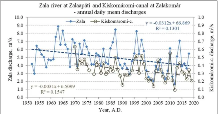
Two tributaries (Zala river at the Zalaapáti and Kiskomáromi- canal at the Zalakomár monitoring point) with the longest time series data of discharge monitoring were analysed by dividing the time series to two equal length periods (in case of Zala river the length of the time series is an odd number, so 34 and 33 years long periods were analysed). The discharge time series for the two tributaries are shown in Fig.4. Both of the fitted linear regression lines show decreasing trends and the correlations are statistically significant at p < 0.01 level. Comparison of the discharge data of the two equal-length periods is shown in Table 3. As it is shown in Table 3., annual daily mean discharge of Zala river and Kiskomáromi-canal decreased by 20.1 % and 12.6%, respectively. Ant the same time, the coefficients of variation of discharges increased by 57.6% and 45.9 %. Calculating the discharge values at the two end points of the regression lines for Zala river and Kiskomáromi-canal resulted in 34.9% and 37.7% decrease, respectively. Taking into account the 20.1%
and 12.6 % decrease in discharges of Zala river and Kiskomáromi-canal, respectively, the combined impact on the NWB corresponds to -67 lake mm/year. The decreasing trends of average discharges of tributaries might be alarming enough concerning the long-term future of Lake Balaton, but another aspect is the increasing variability, i.e. occurrence of extreme values as manifestation of climate change that has been in progress in recent decades (EULAKES Project;
Némethy and Molnár, 2014).
Table. 2. Analysis of discharge trends of the tributaries of Lake Balaton. The numbers mean cases found out of the total of 26 discharge monitoring points (reprocessed data of Kutics et. al., 2016)
Minimum discharge Mean discharge Maximum discharge Percent of
total Trend Winter Summer Year Winter Summer Year Winter Summer Year
Negative 20 20 20 22 19 22 13 16 14 73.1
Positive 5 5 5 4 7 4 11 9 11 26.9
Trend with p<0.1 statistical significance level
Negative 13 11 10 9 7 8 5 3 5 84.5
Positive 2 2 3 0 2 1 1 1 1 15.5
92
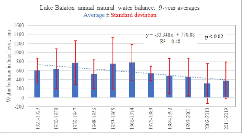
In order to have an integrated picture, the available time series of NWB of Lake Balaton was divided into 11equal periods of 9-year length. Means, standard deviations and coefficients of variation (CV) were determined for each period. Means and the respective standard deviations are shown in Fig.5. It is obvious that even the applied 9-year averaging of NWB data shows a strong decreasing trend with high statistical significance. The standard deviations are high, indicating that even in the relatively short periods the NWB values may change drastically on year-to-year basis. Fig. 6 shows the CV values for each 9-year period. The fitted linear regression line shows definite increasing trends with statistical significance of p < 0.03. These results indicate that climate change may already have a serious impact on the natural water balance of
Lake Balaton and, provided the trends do not change, the water surplus of the lake may disappear.
Human impacts on the water balance
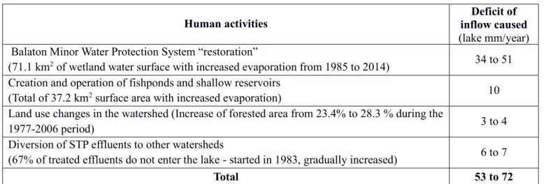
In addition to the global-scale impact, i.e. climate change, there are other anthropogenic factors that have a negative impact on the NBW of the lake. Kutics et al. (2016) analysed the impact of various human interventions that took place in the watershed in the last 6 or 7 decades. All of these interventions were measures to stop eutrophication of Lake Balaton and improve water quality. Human activities include the restoration (rather re-creation a wetland that resembles the historical one) of the so called Kis-Balaton (Balaton Minor)
Figure 4. Annual daily mean discharges of the two tributaries with the longest available time series data
Table 3. Analysis of the discharge time series data of two tributaries of Lake Balaton
Zala River at Zalaapáti village Kiskomáromi Canal at Zalakomár village Period Mean discharge,
m3/s
Coefficient of
variation, % Period Mean discharge, m3/s
Coefficient of variation, % Calculated from monitoring data Calculated from monitoring data
1952-1985 (34y) 5.534 25.5 1970-1994 (25y) 0.364 27.00
1986-2018 (33y) 4.419 40.2 1995-2019 (25y) 0.318 39.4
Change, % -20.1 57.6 Change, % -12.6 45.9
Mean discharge estimated from linear trend equation (p=0.0027)
Mean discharge estimated from linear trend equation (p=0.0052)
1952 5.997 1970 0.403
2018 3.907 2019 0.251
Change, % -34.9 Change, % -37.7
© 2020 The Author(s). Ecocycles © European Ecocycles Society, ISSN 2416-2140 Volume 6, Issue 1 (2020)
93
Analysis of the variability of natural water balance
Figure 5. Trend of the natural water balance for 9-year periods
Figure 6. Change in the variability of natural water balance
94
wetland area that was drained more than a century ago and the creation of more and more shallow fishponds and reservoirs. These new water surfaces are very shallow and increase evaporation of the water of tributaries. Increasing the area of forests results in retaining of precipitation and increased evapotranspiration. Diversion of the treated effluents od sewage treatment plants (STPs) has a small impact on water balance while reduces the nutrient load to the lake. The impacts of these measures on the water balance of Lake Balaton are shown in Table 4.
Another human activity with remarkable impact was the beginning of bauxite mining in the 1960s accompanied by large scale withdrawal of karstic water in the northern watershed characterized by limestone structures. In the period of intensive mining, as much as 5 m3/s water was withdrawn by pumps resulting the drop of the karst water table by more than a hundred meters at some locations. Part of this pumped water (ca. 2.1 – 3.3 m3/s) entered the lake through the Kétöles creek. As a “side effect” several of the natural springs feeding the tributaries of the area disappeared, resulting in a sharp drop in the respective discharges. The water withdrawal was stopped in 1991. However, the discharges of the springs did not return instantly, the time lag was more than 20 years, and only recent data suggest that the recharging of the karst water table is still going on. At the peak of mining activities, the water “surplus” entering the lake corresponded to some 100 lake mm/year (Kutics et al., 2016). The “surplus” is only apparent since the discharges of the tributaries – not being monitored regularly at that time – before the start of the mining activities are not known. Therefore, stopping the withdrawal of karst water has had a long-term impact on the NWB of the lake, but the exact figure for the present is not known. If it is supposed that the total (pumped and natural) discharge was equal to the natural discharge that prevailed before the start of pumping, it can be concluded that some 66- 82 lake mm/year inflow is still missing from the NWB.
In summary, the effect of global and local human impacts on the NWB of Lake Balaton add up to 186 – 221 lake mm/year deficit at the input side of the water balance. It should be mentioned that the difference in the NWB between the 99- year period and the last 30 years is 211 lake mm/year being in the range of the above estimation. A more detailed analysis
of the changes in the various NWB elements, taking into account of the beginning and duration of human interventions, would reveal more causal relationships.
Projections of the impact of climate change on the water balance
Based on the previous sections, it became obvious that climate change has already been exerting impact on the hydrology of Lake Balaton. In addition, climate change affects ice conditions and water temperature of the lake as well (Soja et al., 2014).
Results of the EULAKES project
A number of prediction efforts were made to estimate the impacts of climate change on water balance and water quality of Lake Balaton (Kutics et al. 2007 – GEF/UNDP Balaton Adaptation Project, Farkas et al. 2012 and Kutics & Molnár 2013 EULAKES project).
Figure 7. Figure 7. Water balance of Lake Balaton constructed according to the results of the EULAKES Project predictions (after Kravinszkaja and Varga, 2012)
In Farkas et al. (2012) based on the regionalized version (Züger & Knoflacher, 2011, 2012) of the A1b global scenario, Table. 4. Impacts of human activities on the water budget of Lake Balaton (reprocessed from Kutics et al, 2016)
Human activities Deficit of
inflow caused
(lake mm/year) Balaton Minor Water Protection System “restoration”
(71.1 km
2of wetland water surface with increased evaporation from 1985 to 2014)
34 to 51Creation and operation of fishponds and shallow reservoirs
(Total of 37.2 km
2surface area with increased evaporation)
10Land use changes in the watershed (Increase of forested area from 23.4% to 28.3 % during the
1977-2006 period)
3 to 4Diversion of STP effluents to other watersheds
(67% of treated effluents do not enter the lake - started in 1983, gradually increased)
6 to 7Total 53 to 72
© 2020 The Author(s). Ecocycles © European Ecocycles Society, ISSN 2416-2140 Volume 6, Issue 1 (2020)
95
Kravinszkaja and Varga made predictions of the expectable changes of the water balance elements of Lake Balaton.
Rearranging their results into a visual form, water balance elements of Lake Balaton are shown for the past (baseline period) and two forecasted 30-year long periods. In the 2021- 2050 period slightly increased precipitation compensates for the modest increase in precipitation, but in the 2051-2080 period evaporation from the lake and evapotranspiration on the watershed (reducing inflow) increases due to the increase of annual average temperature by about 3 oC would result in endorheic situation and eventually the shrinkage of the lake.
Results of the NAGIS project
The NAGIS (or NATÉR in Hungarian), the National Adaptation Geo-Information System, is a multipurpose geo- information system that can facilitate the policy-making, strategy-building and decision-making process related to the impact assessment of climate change and founding necessary adaptation measures in Hungary. It includes climate predictions on national or regional level (https://nater.mbfsz.gov.hu/en). The ALADIN model was applied to national level as well as for the Lake Balaton Watershed.
Figure 8. Annual average temperature increases for Hungary in the 2021-2050 (upper map) and the 2071-2100 (lower map) periods as compared to the 1961-1990 reference period (https://map.mbfsz.gov.hu/nater/)
In Fig.8 estimated changes of temperature for the whole country are shown for two 30-year periods 2021-2050 and 2071-2100 as compared to the 1961-1990 reference period.
The annual average temperature of the country is expected to increase by 1.5 to 2 oC in the 2021-2051 period, while a 3 to
3.5 oC elevation is expected for the 2071-2100 period. These figures are in agreement with the data used in the EULAKES project. The ALADIN model was run for the Lake Balaton watershed as well. Detailed results for meteorological variables and water budget elements are available in Nováky et al. (2016). As a summary on the impact of climate change Fig.9 shows the changes for the reference period as well as the two prediction periods. The tendencies are similar those of the EULAKES model and both models predict that the NWB becomes negative in the last decades of the 21st century.
Figure 9. Changes of NWB for the reference period and the two prediction periods.
Conclusions
Being an invaluable national asset for land locked Hungary by providing a host of ecological services and inspiration, livelihood for its population and, together with its watershed, the target region for creating one of the largest eco-museums in Europe (Némethy, 2019), the very existence of Lake Balaton is a precondition for the well-being of millions of people.
Lake Balaton has been an exorheic lake with significant water surplus. Elements of the water balance are reliably monitored since 1921. For the entire 1921-2019 period, the average (controlled) outflow is 551 lake mm/year corresponding to 6.4 year of hydraulic retention time (HRT). In the last 30-year period, the average outflow decreased to 329 lake mm/year corresponding to an HRT of 10.7 year. This phenomenon bears consequences to the ecological system, food web and water quality of the lake. Human activities (local and global) already have an impact on the natural water balance of the lake. Reduction of inflow of most of the tributaries is statistically significant. Annual average discharge of the dominant tributary Zala river at Zalaapáti village (situated just upstream of the vast, 71 km2 reconstructed wetland of Balaton Minor, therefore not influenced by its increased evaporation) decreased by more than 20 %, and the coefficient of variation increased by 58 % indicating the shift to more extreme flow conditions.
The natural water balance (NWB) of the lake shows a 37%
decrease in the last 30 years as compared to the long-term (99 years) average. In addition, the decreasing trend of NWB is statistically significant at p=0.02 level, while the decrease in the coefficient of variation of NWB is significant at p=0.03 level indicating that the water balance of the lake has already
96
been changing into the direction of greater variability, i.e. the occurrence of extreme situations is becoming more probable.
Climate change models show that the ongoing deterioration of the water balance of the lake becomes serious in the second half of the century and the lake basin becomes endorheic provided the present trends do not change or water is not conveyed from another watershed.
Acknowledgements
The research work and the publication of this case study has been supported by the Interreg Central Europe project CULTURECOVERY through Lake Balaton Development Coordination Agency (LBDCA).
The purpose of the project is the conservation (i.e.
preservation, revival and use) of intangible cultural heritage such as traditions, knowledge, and handicrafts through ecomuseums, which have a great potential for preserving the identity of places and people. An important aim of the project to develop innovative solutions for a wider audience, including local citizens and tourists.
References
Bachmann R. W., M. V. Hoyerand D. E. Canfield Jr. (2000):
The potential for wave disturbance in shallow Florida lakes.
Lake and Reservoir Management, 16(4):281-291.
DOI: https://doi.org/10.1080/07438140009354236
Baranyi, S. (1975): The hydrological characteristics of Lake Balaton. Studies and research results. In Hungarian (A Balaton hidrológiai jellemzői. Tanulmányok és kutatási eredmények), 45. VITUKI, Budapest, ISBN 963 511 000 6
Bendefy L. (1968): Water level variations of Lake Balaton from the Neolithic to present day. In Hungarian (A Balaton vízszintjének változásai a neolitikumtól napjainkig) Hidrológiai Közlöny, 6, p257-263.
Bendefy L., V. Nagy I. (1969): Water level variations of Lake Balaton through centuries. In Hungarian (A Balaton évszázados vízszintváltozásai). Műszaki Kiadó, Budapest, pp. 222.
https://library.hungaricana.hu/en/view/VizugyiKonyvek_01 7/?pg=2&layout=s
Farkas A., Kravinszkaja G., Kutics K., Pomogyi P., Varga Gy. (2012): Project EULAKES Ref. No. 2CE243P3, European Lakes under Environmental Stressors (Project report), Lake Balaton Development Integration Agency NP Ltd., Siófok
Håkanson L. (1982): Lake bottom dynamics and morphometry: the dynamic ratio. Water Resources Research 18:1444-1450. https://doi.org/10.1029/WR018i005p01444 HYDROSYS (Víz- és Környezetvédelmi Fejlesztő Szolgáltató Kft.), (2014): Status assessment of the main karst water reservoir of the Transdanubian Central Mountains in 2013. Research report, in Hungarian (A Dunántúli- középhegység főkarsztvíz-tárolójának 2013. évi állapotértékelése. Kutatási jelentés) KDT Vízügyi Igazgatóság, Székesfehérvár
Kravinszkaja G., Varga Gy., Pappné Urbán J. (2012):
Warning signs in the water management of Lake Balaton. - The Hungarian Hydrological Society XXIX. National Wandering Assembly, Eger, July 6-7, 2011. in Hungarian (Figyelmeztető jelek a Balaton vízháztartásában. — A Magyar Hidrológiai Társaság XXIX. Országos Vándorgyűlése, Eger, 2011. július 6–7). CD-edition, ISBN 978-963-8172-29-7
Kutics, K. (2015): The history of human interventions in the environment of Lake Balaton – downs and ups, in Molnár, G., Kutics, K., Farkas, S. eds.: Interaction of Natural and Social Processes in Shallow Lake Areas, Kaposvár University, ISBN 978-963-9821-965.
Kutics K., Kravinszkaja G., Varga Gy. (2016): Role of human impacts on drastic changes of inflow to Lake Balaton…Regional and Business Studies Vol 8 No 2, 39-63, Kaposvár University, Faculty of Economic Science, Kaposvár.
Kutics K., Molnár G., Pintér L., Lehman, A., Chatenoux, A., B., (2007): Lake Balaton: Integrated Vulnerability Assessment, Early Warning and Adaptation Strategies (GEF/UNDP). 2nd Part. Technical tools: indicators, vulnerability assessment, scenarios, integrated modelling. In Climate change: impact, adaptation and vulnerability on the European resource base Central and Eastern European Capacity Building and Awareness Raising Workshop on Vulnerability assessment and adaptation measures under UNFCCC and Kyoto Protocol Budapest, 19–20 November 2007. Geophysical Research Abstracts
Kutics K. and Molnar G. (2013): Could climate change cancel out the results of water quality control measures at Lake Balaton? Geophysical Research Abstracts, Vol. 15, EGU2013-12333, 2013 EGU General Assembly, Vienna.
https://map.mbfsz.gov.hu/nater/
Némethy, S. (2019): The Balaton Ecomuseum – Touristic Product and Landscape Management in One System. In English with English and Polish abstracts; chapter in monography: Parki Narodowe i Otoczenie Społeczno – Gospodarcze. Skazani na Dialog (National Parks and the Socio – economic Environment. Condemned to Dialogue) pp.
© 2020 The Author(s). Ecocycles © European Ecocycles Society, ISSN 2416-2140 Volume 6, Issue 1 (2020)
97
175 – 203. Wyższa Szkoła Turystyki i Ekologii w Suchej Beskidzkiej, ISBN 978-83-947044-1-4
Némethy, S; Molnár, G. (2014): Sustainable management of lakes in connection with mitigation of adverse effects of climate change, agriculture and development of green micro regions based on renewable energy production. International Journal of Environmental Quality (EQA) 13 pp. 21-35., 15 p.
DOI: https://doi.org/10.6092/issn.2281-4485/4527
Nováky B., Varga Gy., Homolya E., Szépszó G., Csorvási A.
(2016): Estimated change of hydrology of Lake Balaton for the impact of climate change, Research Report, National Adaptation Center, NAGIS, 80 pp., Budapest. www.nagis.hu Soja, A. M., Kutics, K., Maracek, K., Molnár, G. and Soja, G., (2014): Changes in ice phenology characteristics of two Central European steppe lakes from 1926 to 2012 - influences of local weather and large-scale oscillation patterns, Climate Change, 126(1–2), 119–133
DOI: https://doi.org/10.1007/s10584-014-1199-8
Virág, Á. (1997): The past and present of Lake Balaton. In
Hungarian (A Balaton múltja és jelene), Eger: Egri Nyomda Kft. 904 pp. ISBN 963 9060 21 6
© 2020 by the author(s). This article is an open-access article distributed under the terms and conditions of the Creative Commons Attribution (CC-BY) license (http://creativecommons.org/licenses/by/4.0/)
Virág Á. (2005): The joint history of the Sió Canal and Lake Balaton. In Hungarian (A Sió és a Balaton közös története (1055-2005). Budapest: Közlekedési és Dokumentációs Kft.550 pp. ISBN 963 229 165 4
Züger J., Knoflacher M. (2011): Regional climate change scenario – Scenario selection and preliminary results.
Deliverable 4.3.2, Project EULAKES Ref. No. 2CE243P3:
European Lakes under Environmental Stressors (Supporting lake governance to mitigate the impact of climate change).
[online] URL: http://eulakes-model.eu/outputs/index.html Züger, J., Knoflacher, M. (2012): Climate Change Scenarios Simulation and Exploration. Deliverable 4.3.3, Final Report 4.3. Uncertainties of scenarios: Regional climate change scenario Project EULAKES Ref. No. 2CE243P3: European Lakes under Environmental Stressors (Supporting lake governance to mitigate the impact of climate change). AIT Austrian Institute of Technology GmbH. [online] URL:
http://eulakes-model.eu/outputs/index.html