Contents lists available atScienceDirect
Aeolian Research
journal homepage:www.elsevier.com/locate/aeolia
Prevailing surface winds in Northern Serbia in the recent and past time periods; modern- and past dust deposition
Milivoj B. Gavrilov
a, Slobodan B. Markovi ć
a,⁎, Randall J. Schaetzl
b, Ivana To š i ć
c, Christian Zeeden
d, Igor Obreht
d, György Sipos
e, Albert Ruman
f, Suzana Putnikovi ć
c, Kathrin Emunds
d, Zoran Peri ć
a, Ulrich Hambach
g, Frank Lehmkuhl
daChair of Physical Geography, University of Novi Sad, Trg Dositeja Obradovića 3, 21000 Novi Sad, Serbia
bDepartment of Geography, Environment and Spatial Sciences, Michigan State University, East Lansing, MI 48824, USA
cInstitute of Meteorology, University of Belgrade, Dobračina 16, 11000 Belgrade, Serbia
dDepartment of Geography, RWTH Aachen University, Templergaben 55, 52056 Aachen, Germany
eDepartment of Physical Geography and Geoinformatics, University of Szeged, Szeged, Hungary
fRepublic Hydrometeorological Service of Serbia, Belgrade, Kneza Višeslava 66, Serbia
gBayCER and Chair of Geomorphology, University of Bayreuth, D-95440 Bayreuth, Germany
A R T I C L E I N F O
Keywords:
Wind rose Dunes Loess Holocene LGM
Banatska Peščara
A B S T R A C T
This study utilizes four different methodological approaches to examine the prevailing surface winds and their associated aeolian processes in Northern Serbia, focusing on the southeastern part of the Carpathian Basin. We utilized wind and atmospheric pressure data from 1939–2014 and 1960–2010 for the climatological analyses.
Geomorphological data and numerical simulations were used to estimate prevailing paleowind systems.
Northern Serbia is currently dominated by surface winds coming from the fourth (270°–360°) and second (90°–180°) quadrants, with frequencies of ca. 116 and 105 days/year, respectively. Comparable frequencies within Banatska Peščara are 115 and 129 days/year, respectively. Crestal orientations of the vast majority of the
≈1300 parabolic dunes here suggest that they have formed from winds derived from the second quadrant, indicating formation during the early Holocene. The remaining dunes, of the transverse type, have orientations aligned to the third quadrant. Grain size analysis of loess deposits near Banatska Peščara points to deposition driven by southeasterly winds, probably during the period between the Last Glacial Maximum (LGM) and the early Holocene. Modern wind measurements and geomorphological data showed that the prevailing winds in the recent and past periods were from the same quadrant, in and around Banatska Peščara. These results were confirmed with an explicit numerical simulation that modelled prevailing winds from the second quadrant during the LGM. Thus, the various geomorphologic and climatic data analyzed in this study show that the general air circulation patterns in the recent period are not dissimilar to those operative during the LGM.
1. Introduction
Atmospheric circulations are often divided into planetary, synoptic, meso-, and small horizontal scales, ranging from 104km to 10 km, re- spectively, and into temporal scales that range from hours to years (Charney, 1948; Haltiner and Williams, 1980). In this paper, atmo- spheric circulations will be analyzed for the prevailing surface winds in Northern Serbia, for both the recent and past periods.
1.1. Prevailing winds and planetary circulations
The term “prevailing wind” is usually applied to descriptions of
permanent winds. We employ the definition from the American Meteorological Society (2000)for prevailing wind: the wind most fre- quently observed during a given time period, over spans of days, months, seasons, and years.White (1831)defined the term“prevailing wind” by describing the regularity in the distribution of the wind at eight compass points, over periods of time measured in days and months. The methods for determination of prevailing winds vary from a simple count of periodic observations to the computation of a wind rose.
The best known and most frequently studied prevailing wind is the Prevailing Westerlies or Westerlies (e.g.,Palmén and Newton, 1969). In this case, the term“prevailing”is used to mark westerly surface winds
http://dx.doi.org/10.1016/j.aeolia.2017.07.008
Received 20 March 2017; Received in revised form 23 July 2017; Accepted 24 July 2017
⁎Corresponding author.
E-mail address:slobodan.markovic@dgt.uns.ac.rs(S.B. Marković).
1875-9637/ © 2017 Elsevier B.V. All rights reserved.
thatflow in an approximately constant direction within the Ferrel cir- culation cells (Fig. 1a). Prevailing easterly surface winds blow out of the Hadley circulation cells on both sides of the Inter Tropical Convergence Zone (ITCZ; Fig. 1a), (e.g., Holton, 1972); these winds are widely known as the Trade winds. Other easterly winds (Polar Easterlies;
Fig. 1a) diverge out of the Polar circulation cells, poleward of the Polar Front (Bjerknes and Solberg, 1922). Unlike the surface winds in the Ferrel cells, Trade winds and Polar Easterlies do not have the term
“prevailing”in their names, but they do have some“prevailing”char- acteristics. In all three cases, these winds blow from approximately constant directions, as a result of the general and semi-permanent cir- culation of the atmosphere (e.g.,Lorenz, 1967).
Other, less permanent, circulations, such as monsoons (e.g.,Saha, 2010), also lead to important prevailing wind patterns that undergo seasonal reversals. The surface winds of the summer monsoon blow from the ocean onto the continent, whereas the winter monsoonalflow is in the opposite direction.
The Polar Front is a planetary circulation (Charney, 1973), along which extra-tropical depressions and/or cyclones develop (e.g.,Djuric, 1994). The Polar Front and its accompanying circulations are the dominant influences on the weather and winds in the middle latitudes, and especially in Central Europe, Southeastern Europe, the Mediterra- nean, and Northern Serbia (e.g.,Gburčik, 1960;Fig. 1).
1.2. Studies of prevailing winds
The study of prevailing winds rose to a higher level of interest very early, before many other world problems. This is understandable, be- cause prevailing winds were drivers for seafaring ventures and other endeavors. In recent decades, research on prevailing winds has become of great practical use around the world for the estimation of wind power (e.g.,Troen and Lundtang Petersen, 1989), for spatial planning (e.g.,Seemi and Bharat, 2012), in health research (e.g.,Cho, 2007) and for wind erosion research (e.g.,Chepil et al., 1964). Geomorphology and aeolian science use information about prevailing winds in research on aeolian landforms and sediments.
According toJanc (2002), the Serbian scientist Andrija Stojkovićin his 1802 book“Physics II” described a northeasterly wind which he called“Szegedinac”(i.e., coming from the town of Szeged in Hungary) near the town of Ruma (Srem subregion) in Northern Serbia. This statement is considered one of thefirst written descriptions of a wind in
Serbia. One of the first articles about observed prevailing winds in Serbia was published byJakšić(1863), showing the frequency of winds at four compass points (or quadrants) per months and seasons, as of 1862.
During thefirst half of the 20th century, research continued on the winds of Serbia and/or Yugoslavia. Conrad (1921) investigated the strong winds (in terms of the Beaufort scale) in southwestern Serbia, and in the mountainous and coastal areas of Montenegro, during World War I.Vujević(1930)explored the winds on the Adriatic island of Hvar (Croatia) for the period of 1871–1880.Küttner (1940)was one of the first to author a paper on the local southeasterly prevailing wind Košava (a.k.a., Koshava, Kossava, Kosava) over Northern Serbia, which is known as the“Banat wind”(i.e., blowing in Banat subregion) (Barbu et al., 2009). Several publications about the Košava wind followed.
Climatological characteristics of the Košava were studied by Milosavljević(1950). The spatial structure of the Košava was presented byVukmirović(1985).Unkaševićet al. (1998, 1999)discussed a sta- tistical analysis of wind data in the main influence area of the Košava wind. A spectral analysis of the Košava wind was presented by Unkaševićet al. (2007), whereas a comprehensive analysis, including basic characteristics, vertical structure and modelling, of the Košava wind was given byUnkaševićand Tošić(2006). More general works regarding winds over Serbia and/or Yugoslavia can be found inVujević (1953), Sokolovićet al. (1984), andGburčik et al. (2006). Upper air flow over Yugoslavia, as well as characteristic surface winds in this area, was examined byDobrilović(1960).
In this study, we focus on the prevailing winds over Northern Serbia, using meteorological, geomorphological, and sedimentological data, as well as data generated in numerical simulations. The main objective of this study is to link climatological, synoptic, geomorpho- logical, and numerical (simulated) data, so as to better understand the atmospheric dynamics of Northern Serbia.
2. Study area
Northern Serbia is located in the southeastern part of the Carpathian (Pannonian) Basin (Fig. 2). The region is mostlyflat, but contains four mountain zones: Vršačke Planine (641 m above mean sea level (AMSL)) and Ramsko Pobrdje (282 m AMSL) in the southeast, Fruška Gora (539 m AMSL) in the southwest, and Avala (511 m AMSL) in the south.
Other significant geomorphological features include two sandy terrains, ITCZ
POLAR FRONT
POLAR FRONT
L
UNDULATION OF THE POLAR FRONT
WESTERLIES
WESTERLIES TRADE WINDS TRADE WINDS
POLAR EASTERLIES POLAR
EASTERLIES
0o 180o
L L
L L L L
L
L L L
90o W 90o E
(a) (b)
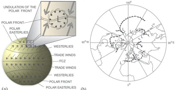
Fig. 1.(a) Generalized representation of the global circulation of the atmosphere, the position of the Polar Front, the prevailing surface winds (arrows), and (b) a typical position of the Polar Front in the Northern Hemisphere, showing centers of low pressure (L), cold, warm, and occluded fronts.
Banatska Peščara (Banat/Deliblato Sands, 250 m AMSL) in the south- east, and Bačka Peščara (Bačka Sands, 134 m AMSL) in the north; as well as six large loess plateaus (Markovićet al., 2008). Forests comprise only about 7% of the investigated region and mainly occur in the mountains and in parts of the sandy terrain along the banks of the Danube, Sava, and Tisa Rivers, and along their main tributaries, while the agriculture land occupies about 84% (70% cereals, 20% industrial crops, and 10% other crops). The six loess plateaus and two sandy terrains preserve important information about aeolian systems during the Late Pleistocene and Holocene (e.g.,Zeeden et al., 2007; Marković et al., 2008; Bokhorst et al., 2009, 2011; Obreht et al., 2015). Dune formation and movement has even been observed in the historical period (Sipos et al., 2016).
In this study, we chose to focus on Banatska Peščara and its sur- rounding loess mantle. During the late Quaternary, the investigated area was primarily influenced byfluvial (Smalley and Leach, 1978) and aeolian processes. Banatska Peščara extends from the Danube River on the SE, to the villages Kovačica and Samošon the NW, covering an area of about 600 km2(Fig. 2). The region can be roughly divided into two parts. On the NE, near the village Dupljaja, there is the highest part of Banatska Peščara with narrow ridge that is dominated by unusual orographic shapes: sandy loess and loess-like sediments called Zaga- jačka Brda (Zagajica Hills, 250 m AMSL) and Dumače (235 m AMSL) (Lukićet al., 2013). The remainder of the region is covered with dune fields, with the central part of the region dominated by dunes that are 1–2 km long and a that area few tens of meters in height. The dunefield was active until a few decades ago (personal observation), having
formed under the influence of the local wind Košava. However, after successfully implementing land amelioration that included reforesta- tion, from the middle of the 18th century to the end of the 20th century, the dunefield has since stabilized.
Northern Serbia is well suited to the study of prevailing winds. First, the low relief and general lack of forest cover provide few obstacles to the wind, i.e., the boundary layer is thin and surface friction is low.
These conditions facilitate the (1) establishment of simple (quasi- geostrophic) relationships between winds and larger atmospheric cir- culations (e.g., Gavrilov, 1985), and (2) exploration of wind-forcing mechanisms. Second, the loess plateaus and dunefields can potentially provide excellent geomorphic information about paleowind systems.
Climatically, the study area is often influenced by undulations of the Polar Front. When the Polar Front moves across the area from across the Atlantic Ocean, across western and central Europe, without retention in the Alps, incursions of cold fronts from the north/northwest follow, which reduce surface temperatures on northwesterly winds, and bring precipitation (Radinović, 1981). When the Polar Front is positioned over the Alps, cyclonic developments usually begin in the western Mediterranean Basin, mostly in the Gulf of Genoa. These processes lead mainly to the incursion of warm fronts into Northern Serbia, which are usually preceded by winds from the southern quadrants. These winds are stronger if a large pressure gradient sets up between a Mediterra- nean cyclone and an anticyclone over the European part of Russia (Gburčik, 1960; Radinović, 1962; Trigo et al., 2002). Occasionally, the study area is under the influence of high pressure ridges of the Azores/
Atlantic or the Siberian anticyclone. In that case, stable, dry weather Fig. 2.Map of Northern Serbia, showing geomorphological characteristics, locations of meteorological stations used in this study, and loess/dune sampling sites. Legend: 1–Mountainous areas, 2–Sandy areas, 3–Loess plateaus, 4–National border, 5–Sampling sites, and 6–Meteorological stations (Table 1).
usually occurs over Serbia (Putnikovićet al., 2016), with mainly calm conditions and very high temperatures in the summer, and corre- spondingly low temperatures during the winter (Unkaševićand Tošić, 2013).
The climate of Northern Serbia is moderate continental, with cold winters and hot summers. The average annual air temperature is 11.1 °C (Gavrilov et al., 2016), and the average annual precipitation is 606 mm (Tošić et al., 2014). According to the De Martonne aridity index, Northern Serbia is characterized by a semi-humid climate (Hrnjak et al., 2014).
3. Methods and data
Our study of prevailing winds utilized four distinct methods. The first two are based on the identification of prevailing winds using two special definitions of this term (Tošićet al., 2017), as applied to me- teorological data on winds and sea level pressure data. The third method uses proxy geomorphologic data from dunes and loess deposits to estimate prevailing paleowinds. Lastly, we also employed a numer- ical atmospheric model to simulate prevailing winds during the Last Glacial Maximum (LGM).
3.1. Recent/modern prevailing winds
We applied two additional definitions of the term prevailing wind (Tošićet al., 2017). Thefirst involves the maximum value of the fre- quency of the observed wind direction, in each of four compass quad- rants: I (00°–90°), II (90°–180°), III (180°–270°), and IV (270°–360°). We note that these quadrants are generally equivalent to NE, SE, SW and NW winds, respectively. This value is obtained as the sum of all of the elementary frequencies in a given quadrant, and is considered to bethe prevailing wind per quadrant. In the second definition, the maximum value of the elementary frequency of the observed wind direction in one of the sixteen elementary directions (interval size is 22.5°) is considered to bethe prevailing wind per (elementary) direction. Using each definition, the mean annual wind data in sixteen directions at each of the 12 meteorological stations within the study area were analyzed (Table 1).
Daily anemometer wind data, reported in degrees (direction) and speed in m/s, from 12 meteorological stations in Northern Serbia (Fig. 2 and Table 1), in accordance with the World Meteorological Organization (1979) and Republic Hydrometeorological Service of Serbia (http://www.hidmet.gov.rs/), were used for the analysis of modern winds. Time series data on winds, i.e., their maximum length periods, from the beginning to the end of year of the observation were also examined (Table 1). At eleven of the 12 stations, the data span a time period > 50 years. As shown inTable 1, data sets were incomplete at three stations, although missing data comprised < 4% of the total data set. Missing values were not estimated; analysis proceeded with
incomplete data as necessary. A quality control check of wind data was passed.
3.2. Classification of circulation types
Putnikovićet al. (2016)classified the weather types over Serbia using the system ofJenkinson and Collison (1977), which is based on Lamb (1972). In this method, grid-point mean sea level pressure (MSLP) values over the area from 32.5°N to 52.5°N and 5°E to 35°E were used to determine direction, strength and vorticity of the geostrophic (Gavrilov, 1985), or upper level, winds. Data from the National Center for En- vironmental Prediction/National Center for Atmospheric Research's (NCEP/NCAR) reanalysis (Kalnay et al., 1996), performed on a 2.5° × 2.5° longitude-latitude grid for the period 1961–2010, were employed for the characterization of the circulation types (CTs). Such data enabled us to develop composite maps for each CT, for the period 1961–2010. The MSLPfields over southeastern Europe were classified and related to the surface circulations over Serbia in order to compare the frequency of wind and circulation types, and to obtain a synoptic characterization of the occurrence and duration of the prevailing winds.
3.3. Geomorphological and sedimentological analysis
Geomorphological analysis was conducted in order to obtain proxy data for prevailing paleowinds for two different areas in and around the Banatska Peščara. Paleowind data were obtained by digitizing dune crests from 1:25,000 topographic maps and satellite images, using a GIS (Fig. 3). Following the identification and classification of the majority of the dunes, the dominant (prevailing) wind directions during their formation were determined, based on the alignments of dune wings and crests (Sipos et al., 2016).
Paleowind directions near Banatska Peščara were also determined from sedimentological characteristics of loess deposits in the vicinity of the villages Dupljaja (DU1), Deliblato (DE1), Dolovo (DO1), Kovačica (KOV1), and Samoš(SAM1) (Figs. 2 and 7). All samples were taken ca.
15 cm below the recent soil (S0), which according toMarkovićet al.
(2015)is in the uppermost part of the youngest loess unit, L1.
Grain size analysis of the loess samples was performed following the methods outlined byNottebaum et al. (2014)andSchulte et al. (2016).
In short,fine-earth subsamples of 0.1–0.3 g (< 2 mm dia.) were pre- treated with 0.70 ml of 30% H2O2at 70 °C for 12 h. This process was repeated until bleaching occurred (Allen and Thornley, 2004), but no longer than three days. To keep particles dispersed, the samples were treated with 1.25 ml, 0.1 M Na4P2O7·10H2O for 12 h (Pye and Blott, 2004). Particle size characteristics were measured with a LS 13320 Laser Diffraction Particle Size Analyser (Beckman Coulter). To calculate the grain-size distribution, the Mie theory was used (Fluid RI: 1.33;
Sample RI: 1.55; Imaginary RI: 0.1) (ISO International Standard 13320,
Table 1
Characteristics of the 12 meteorological stations that supplied data for this study.
No Abbreviation Station Latitude (N) Longitude (E) Altitude (m AMSL) Altitude anemometer (m) Period of record Missing data (%)
1 BE Bečej 45°37′ 20°02′ 84 10 1949–2009 0
2 BC Bela Crkva 44°54′ 21°25′ 90 10 1995–2014 0
3 BG Belgrade 44°48′ 20°28′ 132 24 1939–2014 0
4 KI Kikinda 45°51′ 20°28′ 81 10 1949–2014 0
5 NS Novi Sad 45°20′ 19°51′ 86 10 1949–2014 0
6 PA Palić 46°06′ 19°46′ 102 10 1949–2013 3.1
7 SO Sombor 45°46′ 19°09′ 87 10 1965–2014 4.0
8 SM Sremska Mitrovica 44°58′ 19°38′ 82 10 1949–2001 1.9
9 SU Surčin 44°47′ 20°16′ 73 10 1966–1997 0
10 VG Veliko Gradište 44°45′ 21°31′ 82 10 1965–2014 0
11 VR Vršac 45°07′ 21°18′ 83 10 1965–2014 0
12 ZR Zrenjanin 45°24′ 20°21′ 80 10 1966–2014 0
2009;Schulte et al., 2016). Particle size classes are assumed to be as follows: clay is < 2μm dia.,fine silt is from 2μm to 6.2μm, medium silt is from 6.2μm to 20μm, coarse silt is from 20μm to 63μm, and sand is > 63 µm (Blott and Pye, 2012). The anisotropy of the magnetic susceptibility (AMS) of the loess samples was measured using protocols described inZeeden et al. (2011, 2015), by applying an AGICO KLY-3S Kappabridge.
3.4. Simulation of prevailing winds
Generally, contemporary modelling approaches (e.g., Gavrilov et al., 2014) can provide satisfactory predictions of atmospheric cir- culations, especially for the Polar Front (e.g.,Gavrilov et al., 2011). We utilized the ECHAM5 atmospheric general circulation model (Roeckner et al., 2003, 2004) for numerical simulations of prevailing winds during the LGM. Thisfifth-generation atmospheric general circulation model was developed at the Max Planck Institute for Meteorology (https://
www.mpg.de/institutes) from the spectral weather prediction model of the European Centre for Medium Range Weather Forecasts (ECMWF;
Simmons et al., 1989). The model has yielded good results with sig- nificantly modified geological and hydrological conditions (e.g., Markovićet al., 2014), such as in this study, of LGM conditions. The horizontal resolution (spectral transaction) of the ECHAM5 model is T63 (192 × 96 grid point or 147 km × 147 km on latitude 45°). The model had 31 vertical layers and a time step of 600 s. Other parameters of the model were standardized and/or adjusted to the available com- puting power.
Data from the Paleoclimate Modelling Intercomparison Project Phase III (PMIP3) were used to simulate atmospheric circulations during the LGM, using the following general data: glacier mask, land sea mask, land surface elevation, orbital parameters, pre-industrial trace gases, and solar constant. More information about PMIP3 data can be found inCrucifix et al. (2005, 2012), Haywood et al. (2011), and at https://pmip3.lsce.ipsl.fr. The main atmospheric data used here are the ERA-Interim (ERA-I) reanalysis from ECMWF (Dee et al., 2011). For the purposes of the LGM integrations, information on these initial data have
been modified: surface pressure, sea and land surface temperature, temperature of atmosphere, soil wetness, snow depth,field capacity of soil, surface background albedo, surface roughness length, sea-ice concentration, vegetation type and ratio, soil dataflags, and lake mask.
4. Results
4.1. Recent/modern prevailing winds
Fig. 4shows mean annual wind roses for Northern Serbia, in 16 elementary directions with intervals of 22.5°, with mean speed winds in the percentage at 14 local time (LT) for 12 meteorological stations (Fig. 2). In addition, to make it easier to analyze results,Table 2shows calm periods and frequencies (in the percentage) of winds in 16 ele- mentary directions and 4 quadrants (obtained as the sum of 4 ele- mentary directions). These data show that the prevailing winds in Northern Serbia are from the NW (IV) and SE (II) quadrants (Fig. 4). For a quantitative verification of this impression, the mean annual wind frequency of both quadrants was calculated as the sum of the frequency at each station per quadrant, divided by the number of stations (12).
These data show that the mean annual frequency of prevailing winds in Northern Serbia in the fourth (NW) and second (SE) quadrants is 31.9%
and 28.8% of the time, respectively, or≈116.4 and 105.1 days/year.
Thus, it can be considered that the prevailing winds in Northern Serbia are from the NW and SE quadrants. These winds occur > 60% of the time, or about 222 days/year.The prevailing wind per quadrantis in the fourth (NW) quadrant at nine stations (BE, BG, KI, NS, PA, SO, SM, SU, and ZR), while at the remaining three stations (BC, VG, and VR) it occurs in the second (SE) quadrant (Table 2).
Our analysis indicated the followingprevailing winds per (elementary) direction: six cases in the fourth (NW) quadrant, four cases in the second (SE) quadrant, and in one case in thefirst (NE) and third (SW) quad- rants (Table 2). It should be noted that three cases ofthe prevailing winds per directiondo not belong to quadrants with the prevailing wind per quadrant. At all three stations with SE winds, the prevailing winds per direction are located in the second (SE) quadrant.
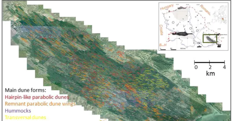
Fig. 3.Satellite and locational maps of the Banatska Peščara, with dunes marked and classified by directionality of wind.
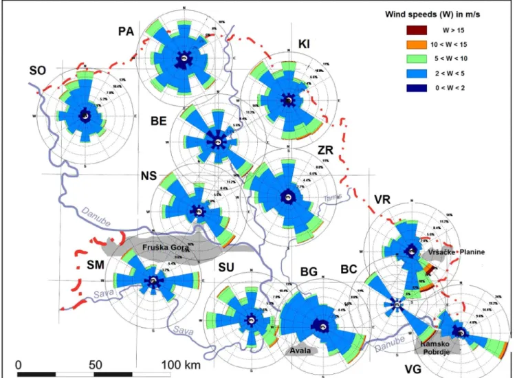
Fig. 4.Wind roses showing the mean annual direction of winds, in 16 directions, and their intensities, at the 12 meteorological stations (Table 1;Fig. 2) for the period 1939–2014.
Table 2
Mean annual wind frequency (%) per quadrant in 16 directions and calm (%), for the 12 meteorological stations at the 14 LT.
The prevailing wind per quadrant is bolded.
The prevailing wind per direction is framed.
Fig. 5.Long-term, annual, mean of sea level pressures forNW (a), andSE(b) weather types, that affected Serbia during the period 1961–2010, showing the ty- pical positions of cyclones (L), anticyclones (H), and fronts, as parts of the Polar Front.
In order to better compare modern vs paleowinds, we analyzed data from the three stations (BC, VG, and VR) that are closest to Banatska Peščara. For these stations,the prevailing wind per quadrant were as follows: 34.8%, 36.7%, and 34.6%, all from the second (SE) quadrant, respectively (Table 2). Average prevailing wind frequencies from the second (SE) and fourth (NW) quadrant near Banatska Peščara are 35.4%
and 31.4% of the time, or≈129.2 and 114.6 days/year, respectively.
Although the difference in the number of days (14.6) between the two quadrants seems small, the effects of the wind are very different. Winds from the second (SE) quadrant are dry and warm, and during their presence there is no significant rainfall, whereas winds from the fourth (NW) quadrant are generally accompanied by precipitation (Putniković et al., 2016).
Prevailing winds in (and around) Banatska Peščara differ from those in Northern Serbia. In Banatska Peščara, prevailing winds blow with the greatest annual frequency (129.2 days) from the second (SE) quadrant, whereas generally in Northern Serbia they blow mainly (116.4 days) from the fourth (NW) quadrant. Hence, the duration of the prevailing wind per quadrant in Banatska Peščara is 12.8 days longer than in Northern Serbia. Additionally, the annual wind duration from the second (SE) quadrant in Banatska Peščara (129.2 days) is 24.1 days longer than in Northern Serbia (105.1 days). The importance of this difference is that, in Northern Serbia, the prevailing winds may better potentially preserve evidence of SE winds within dunes and loess.
4.2. Analysis of circulation types
Among the 26 circulation weather types (CTs) ofPutnikovićet al.
(2016), the relative annual frequencies of CTs that produce winds from the fourth and second quadrants during the period 1961–2010 over Serbia were 13.3% and 18.0%, or≈48.5 and 65.7 days/year, respec- tively. Additionally, the mean annual duration of prevailing winds from the fourth (NW) quadrant was 116.4 days/year, whereas the duration from the second (SE) quadrant was 105.1 days in Northern Serbia and 129.2 days near Banatska Peščara. A strong correlation exists between the frequency of prevailing winds and the CT that drives them. TheNW circulation type (Fig. 5a), representative of the fourth quadrant, has the synoptic situation characterized by High pressure over the Azores and Low pressure (embedded in the Polar Front) over northeastern Europe (Putnikovićet al., 2016). This large-scale distribution of atmospheric pressure promotes advection of northern and northwestern cold and humid air, with frequent precipitation, over Serbia. In the case of theSE type (Fig. 5b), representative of the second quadrant, high pressure
dominates over Eastern Europe (Russia), with low pressure (an un- dulation of the Polar Front on the Alps) over the western and/or central Mediterranean. This distribution of atmospheric pressure leads to ad- vection of warm and dry air, almost without precipitation, into Northern Serbia. These synoptic systems, together with the orography of the eastern Balkans, are the main drivers of southeastern prevailing winds from the second quadrant in Northern Serbia, especially frequent and intensified in the area around the Banatska Peščara. This wind is commonly referred to as Košava wind (Unkaševićet al., 1998). In ad- dition, analyzing the seasonal surface winds in Northern Serbia,Tošić et al. (2017)that the highest frequency of the“northern” circulation types is recorded in summer and“southern”types (SandSE) in autumn and winter.
4.3. Proxy wind data from loess and dunes
Four basic types of dunes were identified in the study area. SW–NE forms were formerly interpreted as longitudinal dunes (e.g.,Bukurov, 1953), which would normally suggest unstabilized, dryland aeolian processes. These were instead newly interpreted as elongated parabolic dunes (320 dunes), i.e., remnant wings (535 dunes) of former parabolic dunes. These dunes are located in the central and NW part of the Ba- natska Peščara (Fig. 3). Wing lengths can reach up to 1.5 km and have heights of ca. 5–10 m (Menković, 2013). The dunes have formed under significant vegetative control and with a moderate sand supply, and are dated to the Early Holocene (Sipos et al., 2016). Hummocks (345 dunes), the initial forms of the parabolic dune association, were de- tected mostly near the Danube River and on the southwestern margin of the dunefield (Fig. 3).
Roughly 100 transverse dunes occur superimposed on parabolic dunes in the central part of the dunefield (Fig. 3). These transverse undulating features often form a 2 km long crest, and have heights of ca. 50 m. Transverse dune formation is enabled by an abundant sand supply and a very limited vegetation control (personal observation).
The last phase of their formation at Banatska Peščara has been placed around the 18th century (Sipos et al., 2016).
Dune crest orientations from the two dune associations reflect varying dominant winds. The older, parabolic dunes have mean and standard deviations of crest directions of 117 ± 6°, whichfit well to the second (SE) quadrant, and with prevailing winds for the recent period (stations BC, VG, and VR) surrounding Banatska Peščara. In the case of transverse dunes, the indicated wind direction is 186 ± 9°, or about a 60° difference between the two wind directions. But if this case is compared with the prevailing winds per direction in the station VR, which is 13.4% from the direction of 180°, one notices the appearance of a southerly wind, which is often present in the recent period.
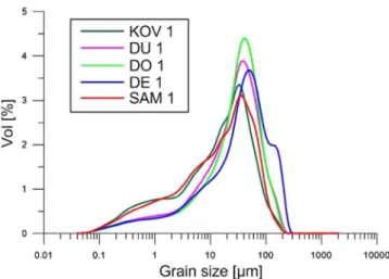
Grain size analyses of loess deposits at thefive sample sites (KOV1, SAM1, DU1, DE1, and DO1) around Banatska Peščara show a spatial trend from relatively coarse grain sizes in the southeast, tofiner grain sizes in the northwest. This trend occurs across allfive sites (Fig. 6).
AMS is a measure of the anisotropic shape of magnetic particles, a lineation in a direction, or in a perpendicular direction, can be inter- preted as loess deposition direction (e.g.,Bradák, 2009; Liu et al., 2005;
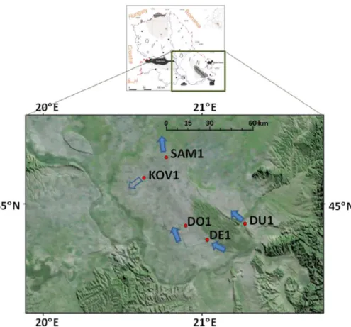
Nawrocki et al., 2006; Zeeden et al., 2015 and references therein), which can represent larger scale atmospheric circulations. AMS data from the loess deposits at three sample sites (DU1, DE1, and DO1) (Emunds, 2015) indicate a preferential SE–NW directionality (Fig. 7).
The results from SAM1, on the northeastern margins of Banatska Peš- čara, are here interpreted as showing SSE–NNW directionality. Samples from KOV1, on the northwestern margins of Banatska Peščara, show a more NE–SW directionality of sedimentary fabric, which may, however, due to their low anisotropy, be regarded as less reliable than other data (Jelinek, 1977).
Fig. 6.Grain size density distribution curve of studied for the loess at the sampling sites DU1–Dupljaja, DE1–Deliblato, DO1–Dolovo, KOV1–Kovačica, and SAM1–Samoš.
4.4. Numerical simulation
Our analysis included a numerical simulation of the undulation of the Polar Front for theSEweather type using ECHAM5, based on as- sumed LGM conditions over the European continent, but especially over Northern Serbia. TheSEtype was selected, as it is the most common cause of winds from the second (SE) quadrant. This type of weather has the greatest impact on aeolian processes around Banatska Peščara for which the geomorphological analysis of paleowinds was performed.
The results of these simulations are displayed using two LGM maps:
mean sea level pressure (Fig. 8a) and winds at 10 m (Fig. 8b).Fig. 8a shows that the LGM Polar Front undulated similarly at the LGM as in the recent times. In northeastern Europe, over modern-day Russia, the mean synoptic conditions placed an anticyclone (H), and to the southeast of Europe in the western Mediterranean, a cyclone (L). This is the same type of the synoptic circulation shown inFig. 5b for theSE weather type. As shown, the numerical simulation can reconstructSE type of weather for the LGM, and thereby reconstruct surface winds in Northern Serbia. As it can be seen inFig. 8b, during the LGM most of Northern Serbia was dominated by winds from the second (SE) quad- rant, whereas a smaller part of the territory to the northwest, on the border of Croatia and Hungary, was affected by a wind from the fourth quadrant.
4.5. Summarized results and two wind zones
Table 3summarizes the key results of the research on prevailing, modern- and paleo-, winds in Northern Serbia. These results are clas- sified according to the different methods used in this study and can be compared to results from previous studies. From the last glacial to the present, Northern Serbia, even though it is a relatively small region, has been divided into two zones with different influences from prevailing winds. The prevailing winds in Banatska Peščara blow from the second (SE) quadrant, whereas in the Bačka subregion winds have pre-
that the results are most complete for Banatska Peščara, for which a richer suite of analyses could be completed.
5. Discussion
Our goal in this research was to investigate the prevailing surface winds in the recent and past periods in Northern Serbia, and especially for the sandy terrains in and around Banatska Peščara.
5.1. Prevailing winds and circulation types for the modern period
Prevailing modern winds were analyzed using surface wind data from 12 meteorological stations spanning the period 1939–2014.
Results showed that the most common directions of winds in Northern Serbia and Banatska Peščara are from the fourth (NW) and second (SE) quadrants with an average of 116.4, 105.1, 114.6, and 129.2 days/year, respectively. As shown, the average number of days with prevailing winds from the fourth (NW) quadrant exceeds the that for prevailing winds from the second (SE) quadrant by 11.3 days/year. The situation is quite different in the area of Banatska Peščara. There, the number of days with winds from the second (SE) quadrant is 14.6 days greater than for winds from the fourth (SE) quadrant.
Winds from the second quadrant are not usually accompanied by precipitation, whereas winds from the fourth quadrant are often asso- ciated with ample precipitation. Thus, different synoptic circulations accompany these two types of winds, as explained in the discussion on the classification of weather types over Serbia (Putnikovićet al., 2016).
Among the 26 circulation weather types observed over the period 1961–2010 in Serbia, the CTs that produce significant winds are from the fourth and second quadrants, with an annual prevalence of 48.5 and 65.7 days, respectively. In addition to these types, other types of weather, such as the A (anticyclone) type, with a prevalence of 67.0 days, can lead to weak winds from all quadrants. Transitions be- tween different types of weather are typically not abrupt in either time Fig. 7.Shaded topography map of the area around the Banatska Peščara, showing selected loess sampling sites (abbreviations same as inFig. 6) and AMS results of the prevailing paleowind directions (arrows).
Fig. 8.The LGM maps of simulated (a) mean sea level at- mospheric pressure, and (b) markedfields of surface winds.
Maps show: current configuration of land, sea, and state borders, and configurations of land, sea, and ice in the LGM conditions, all in accordance with the legend.
Table 3
Prevailing winds per quadrant in Northern Serbia, Banatska Peščara and Bačka subregion, by different analytical methods.
The similarities between the prevailing winds and the circulation types that formed these winds can be explained based on our under- standing of the Polar Front. Undulations of the Polar Front over Northwestern Europe create CTs and winds from the fourth (NW) quadrant, and bring moist air, accompanied by precipitation. Unlike the previous synoptic situations, which are characterized by high pressure over Eastern Europe (Russia) and low pressure over the Western and/or Central Mediterranean (undulation of the Polar Front on the Alps), this wind type creates CTs over Serbia with little precipitation, and dry winds from the second (SE) quadrant.
The Polar Front is one of the most complex atmospheric circula- tions, and is associated with a number of different weather types (e.g., 26 over Serbia), each one variable with respect to frequency and duration. In this study, we found a significant regularity in the behavior of the Polar Front through the presentation of some statistical data, concerning the appearance of various synoptic circulations and pre- vailing winds in Northern Serbia.
Of the many the nested atmospheric circulation systems associated with the Polar Front, the southeasterly wind known locally as Košava is especially important to this study. This local wind has Foehn char- acteristics and is often a warm, dry, and gusty wind, similar to many winds around the world such as the Foehn (Föhn, slopes of the Alps), Santa Ana (Southern California), and Zonda (Argentina) (e.g.,Gavrilov, 2001). The Košava wind occurs in a relatively small area in the southeastern Carpathian Basin, approximately between stations VG and NS (Fig. 4). The speed and duration of the Košava wind depend on the horizontal differences in the surface air pressure between the center of the cyclone in the Western and/or Central Mediterranean and the center of anticyclone over Russia. As the difference in the pressure in- creases, the strength of the Košava wind increases. At station VR, the maximum wind speed recorded was 48 m s−1 on February 11, 1987 (Romanićet al., 2016). As we have seen, the Košava wind is a mesoscale circulation (order of magnitude 102km and durations of a few days). In summary, the Košava wind is not a random event, but rather represents a very organized process that occurs in a complex hierarchy of other circulations, which persist in the atmosphere.
Similar to the way the winter monsoon brings dry air onto the continent, the CTs which lead to winds from the second (SE) quadrant bring dry air, usually without precipitation, to Northern Serbia. In contrast, the summer monsoon on the continent brings moist air with rainfall, while in Northern Serbia the CTs from the fourth (NW) quad- rant create advection of moist air, and precipitation. The difference between fourth (NW) and second (SE) quadrant’s circulations types, and the monsoon circulation, is only in terms of continuous duration.
The monsoon lasts for months, whereas the synoptic situation has durations of a few days, but can occur many times annually.
5.2. Geomorphologic evidence
Prevailing paleowinds were studied in the region near Banatska Peščara by analyzing the orientations of 1300 parabolic dunes. The vast majority (ca. 1200) dunes were formed from winds from the second (SE) quadrant, which is similar to the direction of the recent prevailing winds, and which are often a dry, warm wind. If we take into account the fact that the dunes likely formed in the Early Holocene (Sipos et al., 2016), one could argue that the prevailing winds since then have not changed significantly. However, winds that formed the remaining, ca.
100 transverse dunes were mainly from the third (SW) quadrant. The reason for this wind shift was not understood until recently. However, as we can see inTable 2, prevailing wind per direction at the station VR (13.4%) is just 180°. Therefore, we argue that these dunes arose from high-frequency winds from other directions that are close to that of the second (SE) quadrant.
Characteristics of prevailing paleowinds have also been obtained from grain size analysis of loess deposits around Banatska Peščara
loess plateaus here, when compared to more northeasterly sites. Be- cause the Danube River catchment, situated to the south of Banatska Peščara, is the main source of these loess particles (Smalley and Leach, 1978), our grain size data point to prevailing winds from the SE during the loess depositional interval. Thisfindingfits well into the pattern of the prevailing modern winds at three stations (BC, VG, and VR) sur- rounding Banatska Peščara. Thus, we conclude that wind directions during the loess depositional interval were generally similar to those of modern times.
Of thefive AMS results, four cases (DU1, DE1, DO1, and SAM1) show the SE–NW and SSE-NNW directionality, again suggesting the dominance of southeasterly paleowinds (second quadrants) in Banatska Peščara during the last glacial (Fig. 7). Data from the KOV1 site (Fig. 7) suggest prevailing paleowind systems from the NE, which we are un- able to explain.
5.3. Previous geomorphological evidence
Although previous studies have suggested that northerly and northwesterly paleowinds were the dominant winds in the southeastern Carpathian Basin during the LGM (Bokhorst et al., 2009, 2011; Sebe et al., 2011), our study provides strong evidence for prevailing south- easterly winds in this region at that time. Previously, the possibility of the southeasterly winds had been proposed byMarkovićet al. (2008), based on geomorphological evidence. Grain size data for the Orlovat section (Obreht et al., 2015) suggested that southeasterly winds were dominant in the southeastern Carpathian Basin during the previous interglacial, but these data could not be used to determine whether similar winds were also dominant during glacial periods. Our data suggest that it is plausible that the Košava (SE) wind was a dominant wind system during the last several glacial cycles.Obreht et al. (2016) has proposed an interplay of different atmospheric systems between the Balkans and the southern Carpathian Basin during past∼350 ka, where the Košava wind may have played an important role as a border be- tween these two air systems. Nonetheless, our study suggests that southeasterly winds have been dominant in the southeastern Car- pathian Basin, at least during the late last glacial and into the Holocene.
5.4. Simulation data
Numerical simulations confirmed that undulations of the Polar Front could have led to the formation of theSEweather type during the LGM; these conditions favor formation of southeasterly surface winds similar to the Košava wind in study area (e.g., Obreht et al., 2015).
Wind data from the numerical simulation also agree with the geomor- phological and grain size data. The simulated winds of the second (SE) quadrant correspond with dune orientations, most of the loess grain size data, and the analysis of isopachs (Markovićet al., 2008) in the area of Banatska Peščara. Additionally, the results for the northwestern area (Bačka subregion), i.e., winds from the fourth quadrant, coincide with the results obtained by Markovićet al. (2008); isopachs of the last glacial loess (L1) indicate that loess deposition occurred primarily on northerly winds.
6. Conclusions
Ours is an integrative study about prevailing winds in Northern Serbia, from the last glacial maximum to the present. We provided analyses of prevailing winds based on the instrumental data over the past 50–75 years. These data are compared to those during typical paleo intervals (early Holocene, the latest last glacial period, and LGM) (Table 3), which were reconstructed from loess grain size, AMS, aeolian dunes morphology, and model results. All of these data suggest that predominance of two wind directions: southeasterly winds in Banatska Peščara, for all paleo and modern intervals, and northwesterly winds
(Markovićet al., 2008). The study has shown that the SE winds are probably responsible for the formation of dunes in Banatska Peščara and perhaps much of the loess in Northern Serbia. This conclusion is very important for paleoclimate reconstructions of Serbian loess de- positional systems.
The cause of prevailing winds across our study area involves the complex undulations of the Polar Front over Northern Serbia, which create the dominant weather circulations (SEandNWtypes), leading to the prevailing winds we observe today. The numerical simulation of the SEweather type showed that, during the LGM it was possible the un- dulation of the Polar Front as in the recent period, as well as the pre- dominance of southeasterly winds in Northern Serbia.
Further work may determine the extent to which such winds as- sisted in the transport of dust accumulated on the six loess plateaus in Northern Serbia. The most important issue to a better understanding of loess provenance in this region could be the confirmation of whether specific undulations of the Polar Front and the corresponding circula- tion in Northern Serbia, such as prevailing winds from the second and fourth quadrants, may have led to its accumulation, similar to mon- soons in Asia (e.g.,Porter, 2001).
Acknowledgements
This study was supported by the Serbian Ministry of Science, Education and Technological Development–Serbia, under Grants No.
176013 and 176020. FL, CZ and IO wish to thank the German Research Foundation – Germany (Deutsche Forschungsgemeinschaft – Deutschland, DFG) for funding in the frame of the Collaborative Research Center (CRC) 806 ‘Our way to Europe’, subproject B1 The Eastern Trajectory. We acknowledge the use of wind rose software, provided by Daniel Pereira. The authors are grateful to Miroljub Zarić, who helped to determine the positions of weather fronts. All sedimen- tary data are available in the Pangaea database.
References
Allen, J.R.L., Thornley, D.M., 2004. Laser granulometry of Holocene estuarine silts: ef- fects of hydrogen peroxide treatment. The Holocene 14, 290–295.
American Meteorological Society, 2000. Glossary of Meteorology. In: Huschke, R.E. (Ed.) American Meteorological Society, Boston, p. 638.
Barbu, S., Moisa, C., Mircov, V.D., 2009. Kosava–a Baneten wind. Res. J. Agric. Sci. 41, 361–365.
Bjerknes, J., Solberg, H., 1922. Life cycle of cyclones and the polar front theory of at- mospheric circulation. Geofys. Publikasjoner 3, 1–18 NorskeVidenskaps-Akad. Oslo.
Blott, S.J., Pye, K., 2012. Particle size scales and classification of sediment types based on particle size distributions: review and recommended procedures. Sedimentology 59, 2071–2096.
Bokhorst, M.P., Beets, C.J., Marković, S.B., Gerasimenko, N.P., Matviishina, Z.N., Frechen, M., 2009. Pedo-chemical climate proxies in Late Pleistocene Serbiane Ukranian loess sequences. Quatern. Int. 198, 113–123.
Bokhorst, M.P., Vandenberghe, J., Sümegi, P., Lanczont, M., Gerasimenko, N.P., Matviishina, Z.N., Beets, C.J., Marković, S.B., Frechen, M., 2011. Atmospheric cir- culation patterns in central and eastern Europe during the Weichselian Pleniglacial inferred from loess grain size records. Quatern. Int. 234, 62–74.
Bradák, B., 2009. Application of anisotropy of magnetic susceptibility (AMS) for the determination of paleo-wind directions and paleo-environment during the accumu- lation period of Bag Tephra. Hungary. Quatern. Int. 198, 77–84.
Bukurov, B., 1953. Morphological representation of the Vojvodina. Proceedings of the Matica Serbian, Series Natural Sciences 4, 100–133 (in Serbian).
Charney, J.G., 1948. On the scale of the atmospheric motions. Geofys. Publikas. 17, 251–265.
Charney, J.G., 1973. Planetaryfluid dynamics. In: In: Morel, P. (Ed.), Dynamic Meteorology D. Reidel Publishing Company, Dordrecht-Holland, pp. 97–351.
Chepil, S.W., Siddoway, F.H., Armbrust, D.V., 1964. Prevailing Wind Erosion Direction. J.
Soil Water Conserv. 19, 67–70.
Cho, H.J., 2007. Effects of Prevailing Winds on Turbidity of a Shallow Estuary. Int. J.
Environ. Res. Public Health 4 (2), 185–192.
Conrad, V., 1921. Beiträge zu einer Klimatographie der Balkanländer. Den Akademie der Wissenschaften in Wien. Mathem.-naturw. 130, 425–467.
Crucifix, M., Braconnot, P., Harrison, S.P., Otto-Bliesner, B., 2005. Second phase of pa- leoclimate modelling intercomparison project. Eos 86, 264.
Crucifix, M., Harrison, S., Brierley, C., 2012. Recent and deep pasts in paleoclimate model intercomparison project. Eos 93, 539.
Dee, D.P., Uppala, S.M., Simmons, A.J., Berrisford, P., Poli, P., Kobayashi, S., Andrae, U., Balmaseda, M.A., Balsamo, G., Bauer, P., Bechtold, P., Beljaars, A.C.M., van de Berg,
L., Bidlot, J., Bormann, N., Delsol, C., Dragani, R., Fuentes, M., Geer, A.J., Haimberger, L., Healy, S.B., Hersbach, H., Hólm, E.V., Isaksen, L., Kållberg, P., Köhler, M., Matricardi, M., McNally, A.P., Monge-Sanz, B.M., Morcrette, J.-J., Park, B.-K., Peubey, C., de Rosnay, P., Tavolato, C., Thépaut, J.-N., Vitart, F., 2011. The ERA-Interim reanalysis: configuration and performance of the data assimilation system. Quart. J. Roy. Meteorol. Soc. 137, 553–597.
Djuric, D., 1994. Weather Analysis. Prentice-Hall, New Jersey, pp. 304.
Dobrilović, B., 1960. Upper airflow over Yugoslavia and characteristic surface winds.
Papers 3. Faculty of Sciences, Belgrade, pp. 144 (in Serbian).
Emunds, K., 2015. Reconstruction of paleowinds on the base of sediment properties in Deliblatska Pešèara, Serbia. Master Thesis Department of Geography, RWTH Aachen University, Germany, pp. 86 (in German).
Gavrilov, M., 1985. Frequency of quasi-geostrophic modes over grid points and definition of geostrophic wind. Idöjárás 89, 77–85.
Gavrilov, M.B., 2001. Aviation meteorology. JAT Flight Academy, Vršac, Serbia, pp. 300 (in Serbian).
Gavrilov, M.B., Jovanović, G.R., Janjić, Z., 2011. Sensitivity of a long-range numerical weather forecast model to small changes of model parameters. Adv. Sci. Res. 6, 13–18.
Gavrilov, M.B., Tošić, I.A., Rančić, M., 2014. Numerical Method in Meteorology: Solved Problems. LAP LAMBERT Academic Publishing, Saarbrücken, Germany, pp. 158.
Gavrilov, M.B., Tošić, I., Marković, S.B., Unkašević, M., Petrović, P., 2016. The analysis of annual and seasonal temperature trends using the Mann-Kendall test in Vojvodina, Serbia. Idöjárás 120, 183–198.
Gburčik, P., 1960. The Influence of Alps on the Change of Vorticity, over the Gulf of Genoa. Geofis. Pura. Appl. 45, 238–248.
Gburčik, P., Gburčik, V., Gavrilov, M.B., Srdanović, V., Mastilović, S., 2006.
Complementary regimes of solar and wind energy in Serbia. Geogr. Pannonica 10, 22–25.
Haltiner, G.J., Williams, R.T., 1980. Numerical Prediction and Dynamic Meteorology.
John Wiley, New York, pp. 477.
Haywood, M.A. Ramstein, G., Abe-Ouchi, A., 2011. Comparing structurally different climate models in a paleoenvironmental contex. Eos, 92, 180. onlinelibrary.wiley.
com/ http://dx.doi.org/doi/10.1029/2011EO210005/pdf.
Holton, J.R., 1972. An Introduction to Dynamic Meteorology. Academic Press, New York, pp. 320.
Hrnjak, I., Lukić, T., Gavrilov, M.B., Marković, S.B., Unkašević, M., Tošić, I., 2014. Aridity in Vojvodina, Serbia. Theor. Appl. Climatol. 115, 323–332.
http://www.hidmet.gov.rs/. Accessed 10/24/2016.
https://pmip3.lsce.ipsl.fr/. Accessed 05/06/2016.
https://www.mpg.de/institutes. Accessed 10/24/2016.
ISO International Standard 13320, 2009. Particle size analysis–Laser diffraction methods.
Jakšić, V., 1863. Statistics of Serbia. Ministry of Finance, Reports 1, 188–197 (in Serbian).
Janc, N., 2002. Meteorology in Works of Atanasije Stojković. Arhimedes, Belgrade, p. 96 (in Serbian).
Jelinek V. 1977. The statistical theory of measuring anisotropy of magnetic susceptibility of rocks and its application. Geofyzika Brno 874.
Jenkinson, A.F., Collison, F.P., 1977. An initial climatology of gales over the North Sea.
Synoptic Climatology Branch Memorandum 62, Meteorological Office, Bracknell, UK.
Kalnay, E., Kanamitsu, M., Collins, W., Deaven, D., Gandin, L., Iredell, M., et al., 1996.
The NCEP/NCAR 40-year reanalysis project. Bull. Am. Meteorol. Soc. 77, 437–470.
Küttner, J., 1940. Der Kosava in Serbien. Meteorol. Zeitschrift 57, 120–123.
Lamb, H.H., 1972. British Isles Weather Types and a Register of Daily Sequence of Circulation Patterns, 1861–1971, Geophysical Memoir 116. HMSO, London UK, pp. 85.
Liu, B., Saito, Y., Yamazaki, T., Abdeldayem, A., Oda, H., Hori, K., Zhao, Q., 2005.
Anisotropy of Magnetic Susceptibility (AMS) Characteristics of Tide-Influenced Sediments in the Late Pleistocene-Holocene Changjiang Incised-Valley Fill, China. J.
Coast. Res. 215, 1031–1041.
Lorenz, E.N., 1967. The Nature and Theory of the General Circulation of the Atmosphere.
World Meteorological Organization, Geneva, pp. 161.
Lukić, T., Hrnjak, I., Marković, S.B., Vasiljević,Đ.A., Vujičić, M.D., Basarin, B., Gavrilov, M.B., Jovanović, M., Pavić, D., 2013. Zagajica Hills as an archive of paleoclimatic and paleoecological characteristics and possibilities for geoconservation. Nat. Conserv.
53, 59–71 (in Serbian).
Marković, S.B., Bokhorst, M., Vandenberghe, J., Oches, E.A., Zöller, L., McCoy, W.D., Gaudenyi, T., Jovanović, M., Hambach, U., Machalett, B., 2008. Late Pleistocene loess-paleosol sequences in the Vojvodina region, North Serbia. J. Quatern. Sci. 23, 73–84.
Marković, S.B., Ruman, A., Gavrilov, M.B., Stevens, T., Zorn, M., Komac, B., Perko, D., 2014. Modeling of the Aral and Caspian Seas drying out influence to climate and environmental changes. Acta Geogr. Slov. 54–1, 143–161.
Marković, S.B., Stevens, T., Kukla, G.J., Hambach, U., Fitzsimmons, K.E., Gibbard, P., Buggle, B., Zech, M., Guo, Z.T., Hao, Q.Z., Wu, H., O’Hara-Dhand, K., Smalley, I.J., Ujvari, G., Sümegi, P., Timar-Gabor, A., Veres, D., Sirocko, F., Vasiljević, Dj.A., Jari, Z., Svensson, A., Jović, V., Kovács, J., Svirčev, Z., 2015. The Danube loess strati- graphy–new steps towards the development of a pan-European loess stratigraphic model. Earth Sci. Rev. 148, 228–258.
Menković, Lj., 2013. Eolian Relief of Southeast Banatian. Bull. Serb. Geograph. Soc. XCIII- 4 1–12.
Milosavljević, M., 1950. Physical Characteristics of Winds in Belgrade. Belgrade, Serbia, p. 67 (in Serbian).
Nawrocki, J., Polechońska, O., Boguckij, A.,Łanczont, M., 2006. Palaeowind directions recorded in the youngest loess in Poland and western Ukraine as derived from ani- sotropy of magnetic susceptibility measurements. Boreas 35, 266–271.
Nottebaum, V., Lehmkuhl, F., Stauch, G., Hartmann, K., Wünnemann, B., Schimpf, S., Lu, H., 2014. Regional grain size variations in aeolian sediments along the transition between Tibetan highlands and north-western Chinese deserts–the influence of geo- morphological settings on aeolian transport pathways. Earth Surf. Process. Landf. 39, 1960–1978.
Obreht, I., Zeeden, C., Schulte, P., Hambach, U., Eckmeier, E., Timar-Gabor, A., Lehmkuhl, F., 2015. Aeolian dynamics at the Orlovat loess–paleosol sequence, northern Serbia, based on detailed textural and geochemical evidence. Aeolian Res.
18, 69–81.
Obreht, I., Zeeden, C., Hambach, U., Veres, D., Marković, S.B., Bösken, J., Svirčev, Z., Bačević, N., Gavrilov, M.B., Lehmkuhl, F., 2016. Tracing the influence of Mediterranean climate on Southeastern Europe during the past 350,000 years. Sci.
Rep. 6, 36334.
Palmén, E., Newton, C.W., 1969. Atmospheric Circulation Systems. Their Structural and Physical Interpretation. Academic Press, New York, pp. 606.
Porter, S.C., 2001. Chinese loess record of monsoon climate during the last glacial-in- terglacial cycle. Earth Sci. Rev. 54, 115–128.
Putniković, S., Tošić, I.,Đurđević, V., 2016. Circulation weather types and their influence on precipitation in Serbia. Meteorol. Atmos. Phys. 128, 649–662.
Pye, K., Blott, S.J., 2004. Particle size analysis of sediments, soils and related particulate materials for forensic purposes using laser granulometry. Forensic Sci. Int. 144, 19–27.
Radinović, Dj., 1962. Thermal an Dynamical Conditions of the Cyclone Formation in the West Mediterranean. (Doctorial thesis) University of Belgrade, Belgrade, pp. 101 (in Serbian).
Radinović, Dj., 1981. Weather and climate in Yugoslavia. IRO Građevinska knjiga, Belgrade, p. 423 (in Serbian).
Roeckner, E., Bäuml, G., Bonaventura, L., Brokopf, R., Esch, M., Giorgetta, M., Hagemann, S., Kirchner, I., Kornblueh, L., Manzini, E., Rhodin, A., Schlese, U., Schulzweida, U., Tompkins, A., 2003. The atmospheric general circulation model ECHAM5–model description 1. Report 349. Hamburg.
Roeckner, E., Brokopf, R., Esch, M., Giorgetta, M., Hagemann, S., Kornblueh, L., Manzini, E., Schlese, U., Schulzweida, U., 2004. The atmospheric general circulation model ECHAM5, sensitivity of simulated climate to horizontal and vertical resolution 2 II.
Report 354. Hamburg.
Romanić, Dj.,Ćurić, M., Zarić, M., Lompar, M., Jovičić, I., 2016. Investigation of an ex- treme Koshava wind episode of 30 January-4 February 2014. Atmos. Sci. Lett. 17, 199–206.
Saha, K., 2010. Tropical Circulation Systems and Monsoons. Springer, Berlin, pp. 324.
Schulte, P., Lehmkuhl, F., Steininger, F., Loibl, D., Lockot, G., Protze, J., Fischer, P., Stauch, G., 2016. Influence of HCl pretreatment and organo-mineral complexes on laser diffraction measurement of loess–paleosol-sequences. Catena 137, 392–405.
Sebe, K., Csillag, G., Ruszkiczay-Rüdiger, Z., Fodor, L., Thamó-Bozsó, E., Müller, P., Braucher, R., 2011. Wind erosion under cold climate: a Pleistocene periglacial mega- yardang system in Central Europe (Western Pannonian Basin, Hungary).
Geomorphology 134, 470–482.
Seemi, A., Bharat, A., 2012. Wind Field Modifications in Habitable Urban Areas. Curr.
World Environ. 7 (2), 267–273.
Simmons, A.J., Burridge, D.M., Jarraud, M., Girard, C., Wergen, W., 1989. The ECMWF
medium-range prediction models development of the numerical formulations and the impact of increased resolution. Meteorol. Atmos. Phys. 40, 1–3.
Sipos, G., Markovic, S., Tóth, O., Gavrilov, M., Balla, A., Kiss, T., Urdea, U., Meszaros, M., 2016. Assessing the morphological characteristics and formation time of the Deliblato Sands, Serbia. EGU General Assembly 2016, 17–22 April.
Smalley, I., Leach, J.A., 1978. The origin and distribution of the loess in the Danube basin associated regions of East-Central Europe–a review. Sed. Geol. 21, 1–26.
Sokolović, G., Radičević, D., Ranković, S., 1984. Climate Atlas of Socialist Federal Republic of Yugoslavia. Federal Hidrometeorological Institute of Yugoslavia, Belgrade (in Serbian).
Tošić, I., Hrnjak, I., Gavrilov, M.B., Unkašević, M., Marković, S.B., Lukić, T., 2014. Annual and seasonal variability of precipitation in Vojvodina. Serbia. Theor. Appl. Climatol.
117, 331–341.
Tošić, I., Gavrilov, M.B., Marković, S.B., Ruman, A., Putniković, S., 2017. Seasonal pre- vailing surface winds in Northern Serbia. Theor. Appl. Climatol.http://dx.doi.org/
10.1007/s00704-017-2044-6.
Trigo, F.I., Bigg, G.R., Davies, T.D., 2002. Climatology of Cyclogenesis Mechanisms in the Mediterranean. Mon. Wea. Rev. 130, 549–569.
Troen, I., Lundtang Petersen, E., 1989. European Wind Atlas. Risø National Laboratory, Roskilde, Denmark, pp. 656.
Unkašević, M., Tošić, I., 2006. Košava. Academic mind. Belgrade, p. 82 (in Serbian).
Unkašević, M., Tošić, I., 2013. Trends in temperature indices over Serbia: relationships to large-scale circulation patterns. Int. J. Climatol. 33, 3152–3161.
Unkašević, M., Mališić, J., Tošić, I., 1998. On some new statistical characteristics of the wind“Koshava”. Meteorol. Atmos. Phys. 66, 11–21.
Unkašević, M., Mališić, J., Tošić, I., 1999. Some aspects of the wind‘Koshava’in the lower troposphere over Belgrade. Meteorol. Appl. 6, 69–79.
Unkašević, M., Tošić, I., Obradović, M., 2007. Spectral analysis of the“Koshava”wind.
Theor. Appl. Climatol. 89, 239–244.
Vujević, P., 1930. Climate of Hvar, Winds. Bulletin of the Serbian Geographical Society XVI 104–106 (in Serbian).
Vujević, P., 1953. Climate FNR Yugoslavia. Arch. Agric. Sci. VI. 12, 1–46 (in Serbian).
Vukmirović, D., 1985. The spatial structure of the Koshava wind. In XI International Conference on Carpathian Meteorology, Hungarian Meteorological Service, Hungarian, Budapest, 10–15 (in Russian).
White, H.W., 1831. Journal of the Weather kept at Bedford–Art. V. Calendar of Nature in England for 1830, The Magazine of Natural History, and Journal of Zoology, Botany, Mineralogy, Geology and Meteorology VI, 170–173.
World Meteorological Organization, 1979. Technical Regulations Basic Documents No. 2 Volume I–General Meteorological Standards and Recommended Practices. Geneva.
p. 34.
Zeeden, C., Hark, M., Hambach, U., Marković, S.B., Zöller, L., 2007. Depressions on the Titel loess plateau: Form–Pattern–Genesis. Geogr. Pannonica 11, 4–8.
Zeeden, C., Hambach, U., Steguweit, L., Anghelinu, M., 2011. Loess stratigraphy using palaeomagnetism: application to the Poiana Cireşului archaeological site (Romania).
Quatern. Int. 240, 100–107.
Zeeden, C., Hambach, U., Händel, M., 2015. Loess magnetic fabric of the Krems- Wachtberg archaeological site. Quatern. Int. 372, 188–194.