Balatonyi, László
1– Lengyel, Bálint
2– Berger, Ádám
3Nature-based solutions as water management measures in Hungary 4
ABSTRACT
Climate change, loss of biodiversity and degradation of ecosystems are all linked and have devasta- ting consequences for our socio-economic stability, health and well-being. Working with nature is increasingly recognized as an efficient way to tackle these growing challenges, according to the new EEA report ‘Nature-based solutions in Europe: Policy, knowledge and practice for climate change adaptation and disaster risk reduction.’ In line with the basin wide updated flood risk strategy like International Commission for the Protection of the Danube River (hereafter: ICPDR) Flood Risk Management Plans 2021. Multilevel action plans have been developed. The EU level plans, such as the EU Strategy for the Danube Region, from the geographical point of view (for example: EU Green Deal) are mainly based on watersheds and on macro-regional scale. However, at the same time, counties should elaborate their strategies on their own level. Hungary has many strategies, one of the most relevant in terms of climate change is the Hungarian National Water Strategy (hereafter:
HNWS), also known as, Kvassay Jenő Plan.
Keywords: climate change, flood risk, risk reduction, runoff management, water conservation
1 Senior lecturer, University of Public Service Faculty of Water Sciences, Department of Water and Environmental Security, Bajcsy-Zsilinszky utca 12-14., 6500 Baja, Hungary. +36(1)432 9000, balatonyi.laszlo@uni-nke.hu, ORCID:
https://orcid.org/0000-0001-5130-730X
2 Referent, General Directorate of Water Managemnet, Márvány utca 1/D., 1012 Budapest, Hungary. lengyel.balint@
ovf.hu.
3 Engineer, University of Public Service Faculty of Water Sciences, Department of Water and Environmental Security, Bajcsy-Zsilinszky utca 12-14., 6500 Baja, Hungary. +36(1)432-9000, berger.adam@uni-nke.hu, ORCID: https://orcid.
org/0000-0001-8964-3536
4 This case study would not have been possible without the “Municipalities as integrators and coordinators in adapta- tion to climate change” LIFE16 CCA/HU/000115 (abbreviation: LIFE_MICACC) project.
INTRODUCTION
The European Union is strongly supporting regional integration to build country resilience towards climate change driven hazards. This cooperation is developed by launching and implementing the EU regional strategies. One of the key problems related to climate change is water management, including flood management and sufficient access to fresh water. Nowadays, the southern region of Europe, like Danube Region including Hungary, is being more and more affected by limited access to fresh water.
Floods are natural phenomena. They shaped natural landscapes, created habitats, and supported ecosystems in floodplains, wetlands, and other lowlands. Floods are impossible to prevent entirely, although measures may be taken to reduce their frequency and the damage they cause.
Increased peak flow occurs where rivers have been cut off from their natural floodplains, forced into man-made embankments, and where houses and industrial sites have been constructed in areas that are naturally flooding. Changes in land use in rural and urban areas can also worsen the effects of flooding.
In the HNWS, it was determined, that the low hilly and hills regions in Hungary are characterized as poor water retention areas, this means that further actions must be taken here to improve the volume of the small reservoirs. Soil erosion occurs when the quality of the soil in an area is degraded or reduced by the destruction of water through the action of gullies. This type of soil degradation is common in sloping areas, including hillsides. For this reason, the usability of the land is limited and erosion control would be very costly, which would reduce the profitability of the land. Small watercourses in the hills, mainly due to the manmade interventions and local developments in these areas, deteriorated from their natural state. However, the hills have a significant role to play in nature conservation. The HNWS has identified the restoration and maintenance of natural state in terms of hillside watercourses as essential objectives, thus promoting water retention. Small scale nature-based solutions are currently being tested in Hungary in relation with the single pilot project. In this paper the methods used in the project’s hillside area will be discussed in detail after a summary of our national hydrological situation.
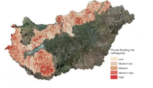
Hungary is a lowland country in the Carpathian basin surrounded by the Alps, the Carpathians and the Dinaric Mountains, however hillsides and low mountain regions add up to 55% of the country’s total area. 60% of the settlements (1 913 pcs) are located on the potentially affected area by pluvial flooding (Figure 1). The huge volume of water flowing down from the mountains slows down on the plains, gets barred, ponded and drifts through the country causing intense floods. The record floods of the last two decades had the Hungarian experts reconsider their views on flood control. The analyses have proved that the old methods of protection are not adequate anymore. In 2011, a preliminary risk assessment was completed, identifying areas at risk of flooding and requiring detailed investigations.
In 2013, the first version of the area hazard and risk maps was produced based on the preliminary risk assessment.
Figure 1. Pluvial flood risk areas in Hungary (Author’s own map)
The flood risk management programme has refined the hazard and risk maps and developed hazard and risk reduction measures at both the national and regional level. During the implementation, the results of the various elements were continuously communicated, giving stakeholders and social organisations the opportunity to provide information and express their views (OVF, 2015).
The dykes getting ever higher increases risks as well. The constant heightening of the 4.425 km long dyke system would put an enormous economic burden on the country. The impacts of climate change are getting more powerful and the situation gets more complicated.
Mass movements are rapid, natural hazard-like. Typical scenes of mass movements are steep banks of rivers, and hilly regions in the case of appropriate lithological and orographic endowments. Three more – mainly low hilly and hills – mesoregions will be endangered by strong mass movement pro- cesses between 2021 and 2050 and then two more till 2100 (Csorba et al., 2012).
Among the extreme weather events that are becoming more frequent with climate change, torna- does, thunderstorms, hurricanes, high winds, hail as convective climate hazards, floods and flash floods as hydrological hazards are typical (Mezősi, 2021). So climate variability is also manifesting itself in more extreme rainfall losses. Measurements show that the national average increase in the number of days with high precipitation above 20 mm is 1.8 days. However, the spatial distribution varies, with the largest increase (6 days) in the area around the Bükk, and a decrease in the Zala hills and Nyírség (Bihari et al., 2018).
In addition, the problems associated with increasing urbanisation are intensifying. This pheno- menon dates back long ago, when settlements at major road junctions, along rivers and estuaries covered increasingly large areas. Over the centuries, these settlements have gradually grown and absorbed population from rural settlements. Thus, increasing urbanisation and the emergence of new economic actors in the area raising a number of new strategic issues for both rural development and water management measures (Szalai & Fabula, 2021).
Among other things, the above-mentioned issues support the case for short term solutions in urban development, which typically involves point interventions. At the same time, however, it involves the involvement of local residents in the initiation and, possibly, implementation of the various elements of the intervention. Interventions are then always aimed at solving a local problem. These problems will become more and more prominent as climate change increases (Schmeller, 2021).
Extreme conditions and intense weather events (droughts and floods) test the capacities of the involved institutions (catastrophe protection agencies, local governmental offices and the water sector) and their economies. There is an increasing trend in the formation of local (point source like) extreme storms and precipitation, which demand quick and effective responses. Most likely these situations will force investment in damage prevention measures, but in any case, flash floods (floods within 6 hours) will happen more often in mountainous areas, where people will have to accept much higher risks (Pirkhoffer et al., 2009; Czigány et al., 2010).
In the Danube River basin, during the previous decade, water services, professional and voluntary organizations involved in flood protection have had to cope with a wide range of extreme hydromete- orological events to ensure that the floods recede with as little damage as possible. The surplus or shortage of water directly impacts local authorities and population, the natural environment and the economic sectors that use and depend on water, such as agriculture, tourism, industry, energy, trans- port, as well as everyone and everything in general. Extreme weather events are already common.
Over the last few decades, climate change accelerated the hydrological cycle (Wild et al., 2008).
Projections suggest that extreme weather events will become more frequent (Balatonyi, 2016) while at the same time, small mountain and hillside rivers often dry up and their water resources cannot be used to any significant extent without reservoir storage during the critical summer low flow period (Somlyódy, 2011).
Through the centuries, the Danube countries suffered from many disastrous flood events. The most significant among these is the 1501 flood on the upper Danube, considered to be the largest summer flood of the last millennium, causing extensive devastation down to Vienna, and presumably, its impact was extreme downstream to the Danube Bend at Visegrád. Among the ice jam-induced floods, the one of 1838 has historical significance. It devastated many settlements from Esztergom to Vukovar, including the towns Pest, Óbuda and the lower parts of Buda on the territory of today’s Hungarian capital. In recent years the major floods occurred in 2002, 2006, 2010, 2013 and 2014 resulting in casualties and damages to economic activities amounting to several billion € (ICPDR, 2021).
Especially in Hungary in the last 10 years, or last 6 years to be more precise, these extreme rainy days have become more numerous and their damage more serious. Infrastructural and other measures will have to be improved to decrease the risks. Hungary’s water management has one primary goal, to retain water in the area, but precipitation is not generally well-managed in our country. Good practices of precipitation as a resource are not well known or accepted. Our towns and cities, the centres of population, infrastructure and industry, are the most vulnerable to climate change and the consequences of extreme weather events, since most of our towns are located directly in the most sensitive geographical areas.
The main aim of this paper is to promote those type of structural measures in Hungary. Top priority was given to NWRM and to measures addressing the climate change but the importance of the structural measures was also recognized by the ICPDR in the updated Danube Flood Risk Management Plan in 2021. NWRM are measures that aim to safeguard and enhance the water storage potential of landscape, soil, and aquifers, by restoring ecosystems, natural features and characteristics of water courses as well as using natural processes. They support Green Infrastructure by contributing to integrated goals dealing with nature and biodiversity conservation and restoration, landscaping, etc. NWRM provide multiple benefits, including flood protection, water quality and habitat improvement. They are adapta- tion measures that use nature to regulate the flow and transport of water to smooth peaks and moderate extreme events (floods, droughts, and desertification). They reduce vulnerability of water resources to climate change and other anthropogenic pressures. They are relevant both in rural and urban areas.
A ‘Macro-regional strategy’ is an integrated framework endorsed by the European Council to address common challenges faced by a defined geographical area relating to EU Member States and third countries located in the same geographical area which thereby benefit from strengthened cooperation contributing to achievement of economic, social and territorial cohesion. In order to increase growth and strengthen cooperation at a macro-regional level the European Union adopted the EU Strategy for the Danube Region (EUSDR) in 2011 with eleven priority areas to harmonise development policies connecting fourteen countries on the Danube basin. The coordination of the Environmental Risks Priority Area (PA5) is managed by Hungary (Ministry of Foreign Affairs and Trade) and Romania (Ministry of Environment, Waters and Forest). The main focus of the work is to address the challenges of water scarcity and droughts in line with the Danube River Basin Management Plan, the report on the impacts of droughts in the Danube Basin in 2015 (due in 2016) and the ongoing work in the field of climate adaptation. Therefore, in the past few years EUSDR PA5 contributed to the elaboration of the ICPDR Climate Change Adaptation Strategy Update 2018, supported project elaboration and implementation in the field of drought management and climate change related spatial planning, disseminated scientific results to anticipate regional and local impacts of climate change through research. Flood risk management is also a significant target of the priority area. In order to achieve reduction of flood risk events EUSDR PA5 provides and enhances continuous support to the implementation of the Danube Flood Risk Management Plan. In case that these prevention measures are not effective enough, disasters occur, therefore EUSDR PA5 is supporting the assessment of disaster risks in the Danube Region, encouraging actions to promote disaster resilience, preparedness and response activities.
An intensification of extreme events, such as floods and droughts, leads to high impacts for agri- culture, forestry and industry, built-up areas and infrastructure. As a consequence of decreasing water levels, a shortage in water supply is expected in some areas. There will not be enough water to meet the requirements for irrigation in agriculture and the vegetation period will shorten in large areas in the south of the Danube River basin (DRB). In contrast, in the northern parts there will be enough water for productive farming. A shift in species distribution and increased risk of invasive species is expected due to changing climatic conditions.
An increase in air and water temperature, combined with changes in precipitation, water availabi- lity, water quality and more frequent extreme weather events, such as floods, low flows and droughts, may lead to long-term changes in ecosystems, life cycles, and biodiversity within the DRB. These are the most relevant impacts of climate change (ICPDR, 2019).
The extreme weather conditions caused by the climate change all around Europe including the Danube Region call for a solution. The frequency of floods, droughts, erosion and drift ice is expected to increase, and directly threaten the population and the economic actors. In addition, in the Danube Region, the high number of industrial risks are associated with the occurrence of permanent environ- mental risks. In the Danube Region there are many flood-risk areas. Climate change is expected to further increase extreme water flows and will also affect water supply. Therefore, common proce- dural rules should be developed to prevent and respond quickly to disasters, linking participants in risk management. The objective is the development of a Climate Adaptation Strategy for the Danube Region with the involvement of tourism, water management, navigation and agriculture, as well as to implement an international Flood Risk Management Plan under the leadership of ICPDR. In relation to floods and climate change, it is important to improve the procedures of regional planning and construction regulation in order to exchange experiences and best practices between communities.
The Danube Region Strategy has been efficiently integrated in the 2014–2020 development period, and the considerations of the Danube Region Strategy have appeared everywhere from the Partner- ship Agreement through various funds used in Hungary to operational and cross-border cooperation programmes. The added value of macro-regional strategies for European territorial cooperation and cohesion policy needs to be assessed based on the nature of the reviewed macro-region.
Cities’ water management systems (safe drinking water, precipitation and sewage management infrastructure) will have to endure the changes of the water cycle (Buzás, 2015). In the HNWS is the framework strategy of the Hungarian water management until 2030 and the medium-term implemen- tation plan for the period until 2020. It emphasizes the importance of precipitation management, the prevention of contamination and uncontrolled flow of precipitation, to safely maintain surface and ground water resources and to decrease pressure on our infrastructure, while trying to keep most of this unused water resource in place.
The scope of the HNWS extends to the whole territory of the country:
• surface and subsurface waters, their beds, banks and water storing formations;
• all establishments and activities that influence or change the runoff and streaming conditions, quantity, quality, including public water supply and wastewater systems;
• management of water resources, exploration of water use possibilities including conservation and improvement of the role of the water in nature;
• prevention and protection from the damages of water;
• survey and exploration of the state of waters, their assessment, research, observation, data collection, processing, dissemination and use;
• the state of the water as habitat and activities influencing it as a landscape forming factor.
• enable our country to avoid the water crisis threatening the world, to take necessary measures in time against its already observable signs;
• preserve the water for the next generation, because it is the condition of life, the prime mover of the economy that cannot be substituted by anything else;
• use its benefits efficiently, with enough security against its threatening damages.
METHODS
As the aim of this publication is to briefly describe the hydrological situation in Hungary and to present nature-based water management solutions in hilly areas, the literature has been selected on this basis. Since national legislation and guidelines typically follow international, and therefore EU, documents, points and ideas from these have been incorporated as deemed relevant for the publica- tion. In addition, national adaptations and the writings of eminent representatives of the profession (e.g. Buzás, 2015; Czigány et al., 2010) have of course, also provided a reference point. The authors also considered it important to briefly present implemented projects, which, in their opinion, could serve as examples of good practice in nature-based water management and water security for other water management units.
The source material used was drawn from library, online and the authors’ own collections. The authors then prepared individual descriptive notes from the compiled source materials, which provided the basis for the conceptual structure, content and ideas of the publication. After the descriptive notes were jointly summarised and outlined, the structure and the main ideas of the paper were developed.
RESULTS
Potential measures for natural water retention
In the cities, precipitation management also has other important benefits for the people and the environment, for example microclimate control and higher biodiversity. Precipitation utilization (control, preservation and further usage) is undoubtably one of the main goals of the water manage- ment sector, but it is also perhaps the most challenging concept, since all input factors (precipitation intensity and potential maximum in given area and time) shift rapidly, hence the management inf- rastructure engineering has to cope with these new conditions. Natural Water Retention Measures (hereafter: NWRM) could be used, where space is limited and large-scale grey infrastructure is not a feasible option. NWRM’s are a collection of different kinds of blue-green techniques, which can be categorized by land use: forestry, agriculture and urban solutions. The main characteristic of these engineering techniques is that they work with the natural setting to maintain or restore natural conditions and mitigate problems with small scale structures while using natural materials.
NWRM’s primary goal is to increase the water storage capacity of soils and wetlands and to decrease the effects of climate change. NWRM’s enhance the retention capacity of aquifers, soil, and aquatic and water dependent ecosystems with a view to improve their status. The application of NWRM’s supports green infrastructure, improves the quantitative status of water bodies and reduces
the vulnerability to floods and droughts. (Strosser et al., 2015) Usually NWRM’s retain surface water, such as the water of rivers or streams, or run-off from precipitation, and then release it slowly, in a controlled manner, to compensate for the difference between periods of abundance and scarcity. With these, the rehabilitation of the local micro-water cycle can be achieved, ultimately contributing to sustainable water management.
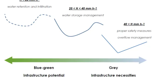
NWRM’s are blue-green infrastructural elements, which can be used under certain hydrological conditions as shown below (Figure 2).
Figure 2. Precipitation intensity and the mitigation possibilities
It is important to point out that in addition to their basic functions, there are many other additional advantages, more so than with grey infrastructure solutions, though at the same time, small NWRM’s are less efficient. Reservoir capacity has the highest efficiency rate in mountains and hilly areas and lowest at the receiving, low areas. The best location is at the edges of the catchment area. The hierarchy is also true in terms of ownership. The stored water can be utilized most effectively at the level of the individual (resident), and then at the level of the municipality (public area) and the state (receiving state watercourse). The main actors are the province, the municipality and the regional water authority (Hartman et al., 2019). This hierarchy is well reflected in the Hungarian legislation.
Property owners are required to manage precipitation on their property, by keeping the water there, but this kind of water resource utilization is not only a legal obligation but also a moral obligation.
Many NWRM’s do not require water rights licensing plans. These include reforestation of arable land, increasing green areas inland, and changing agricultural practices. Developments and activities related to flood protection usually focus on the built environment and citizens. However, where there is a possibility to keep and store water in place, efforts should be made to increase the storage space.
This would not only cut flood peaks, but also help water retention, which is becoming increasingly important due to more uneven and extreme rainfall conditions caused by climate change. Simply put,
by reducing flood waves and even partially keeping this body of water in place, we not only help pro- tect our built environment, but also help improve the water management of our natural environment and protect it from drought, while relieving the burden on our water management facilities.
We have tested several of these in pilot projects and we are currently planning to use these alter- native methods nationwide. Compared to standard development, these are much cheaper, however, several small scale NWRM’s can replace a single large grey infrastructure element. For example, in the hillside town, Püspökszilágy, where flash floods caused significant damage, small wooden barriers on the upper parts of the local streams’ watershed area proved to be effective in slowing down water during storms. Püspökszilágy is located in the Vác district of Pest County, in the southern part of the Western Cserhát, on the watershed of the Danube and Tisza rivers, about 15–16 kilometres southeast of Vác. This is a sack village of approximately 730 people with an area of 25.3 km2. The most significant surface water is the Szilágyi stream, with a catchment area only about 10 km2. The average annual rainfall is only around 600 mm. The settlement has experienced record flash floods every 2–3 years over the last 1–2 decades, which was not typical before. This leads to significant soil depletion and damage to the buildings, while in summer the valley floor dries out completely, adversely affecting agriculture, the ecosystem and groundwater resources. Our aim was to retain water and sediment by the flood wave in the upper catchment before it reaches the built environment.
The construction of wooden barriers can be completed in a couple of days, with local materials, and in case their position is carefully planned, these can be just as effective as a regular dam. Combined with green water storage areas and sediment collection ponds, water quality was also preserved in this town (LIFE-MICACC, 2021). Regarding the catchment area of Szilágyi stream (owned and managed by the Municipality of Püspökszilágy), it should be mentioned that it is located in the 2-10 Zagyva river basin management planning sub-unit. At the same time, half of the public water management area of the municipality is located in the 1-9 Central Danube River Basin Management Planning Sub-unit (Pataki et al., 2021).
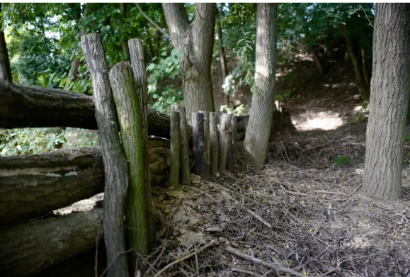
The amount of water retained will provide higher arable lands and forests. At the lower catchment area, in the valley floor, there is typically arable land and a built environment. Here, in a part of the floodplain of the Szilágyi stream, a wetland and lake system suitable for the reception and storage of floods and sediments which was established in order to increase the water retention capacity and reduce the risk of drought. In addition, a wooden bottom sill is built directly above the catchment system to catch sediments. On the Szilágyi stream, from the source to the water passage after the side reservoir, natural interventions were planned at a total of fifteen points on the outskirts of the settlement. During the works, five ancient natural stone mud traps built into individual mortars were found, and their renovation was also part of the project (Figure 3).
Figure 3. NWRM at Püspökszilágy (Author’s own photo, September 2020)
The specifics of the intervention
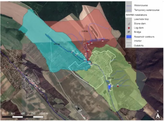
The solution concept is based on two main points: one is to slow down surface runoff and the other is to increase the collection time. A combination of both solutions has been used to mitigate the adverse effects. Infiltration log dams have been installed in the peripheral erosion gullies and a lateral reservoir has been constructed in the lower reaches. Through these interventions (Figure 4), it will be possible to retain water and sediment run-off from the upper catchment and flatten the flash flood curve before it reaches the built environment, causing severe damage. The carefully designed pre-emptive emptying of the lateral reservoir is able to capture and store flash floods. This solution has also allowed a previously regularly flooded area to be reconnected to the hydrological system, providing a suitable environment for aquatic ecosystems and public recreation (Pataki et al., 2021).
The lateral reservoir is characterised by a varied shoreline, with an average length of approximately 250 m, a width of 15–90 m and a surface area of 9000 m2. In order to remove siltation and accumu- lated sediment, sediment traps have been installed at the inflow points of the reservoir. As already mentioned above, seepage log dams were constructed above the settlement in the erosion ditches leading to the Szilágyi stream. The purpose of the dams is to allow the small flows of the stream to flow unhindered through the gaps below, while at the same time, in the event of flash floods, the large flows and the sediment and flotsam that come with them are retained above the settlement.
Figure 4. Location of the water retention solutions used in Püspökszilágy (Pataki et al., 2021)
Water is drained slowly through the gap between the logs under essentially controlled conditions, thus flattening the flood peak. The permeability studies suggest that the free surface area of the log dams is about 15% of the total surface area, but this is likely to be an underestimate due to the characteristics of the method used (Pataki et al., 2021).
CONCLUSIONS
Many countries are already restoring nature in river valleys and uplands to reduce downstream flooding risks. NWRM’s improve the water storage capacity of habitats, soil and groundwater aquifers while improving the condition of waters and water-dependent ecosystems. They extend the green infrastruc- ture network, help to maintain the quantity and quality of water and reduce the area’s vulnerability to droughts, heat waves and floods, all through natural processes, while strengthening ecosystems.
NWRM’s also provide many additional benefits, such as erosion control, soil protection, creation and conservation of natural habitats, microclimate control, and recreational opportunities. The benefits of these water management measures can also be linked to other sectors, such as tourism. Appropriate interpretation tools can be used to meet the needs of visitors and to raise their awareness of water management measures in Hungary. One such tool could be the creation of thematic trails, which could also have a social awareness-raising effect (Horváth & Magyar-Papp, 2016).
REFERENCES
Balatonyi, L. (2016). Villámárvíz, mint potenciális természeti veszélyforrás: Monitoring alapú kisvízgyűjtő optimalizálás a hegy- és dombvidéki árvizek pontosabb előrejelezhetőségéért. GlobeEdit.
Buzás, K. (2015). A városi vízrendszerek megújítása, a klímaváltozáshoz való alkalmazkodás növelése.
Csorba, P., Mezősi, G., Szépszó, G., Blanka, V., Meyer, B., & Vass, R. (2012). Analysis of landscape geographic impacts of potential climate change in Hungary, Landscape &Amp; Environment, 6(1), 41–50. https://ojs.
lib.unideb.hu/landsenv/article/view/2293
Czigány, S., Pirkhoffer, E., Balassa, B., Bugya, T., Bötkös, T., Gyenizse, P., Nagyváradi, L., Lóczy, D., & Geresdi, I.
(2010). Villámárvíz, mint természeti veszélyforrás a Dél-Dunántúlon. Földrajzi Közlemények, 134(3), 281–298.
EU, European Environment Agency (2021). Nature-based solutions in Europe: Policy, knowledge and prac- tice for climate change adaptation and disaster risk reduction. EEA Report No 1/2021, https://www.eea.
europa.eu/publications/nature-based-solutions-in-europe/, https://doi.org/10.2800/919315
Hartmann, T., Slavíková, L., & McCarthy, S. (2019). Nature-Based Flood Risk Management on Private Land - Disciplinary Perspectives on a Multidisciplinary Challenge. Springer. https://doi.
org/10.1007/978-3-030-23842-1
Horváth Z., Magyar-Papp J., & Pálfi A. (2016). A turisztikai térhasználat és a desztináció menedzs- ment összefüggései. Modern Geográfia, 11(4), 1–14. http://www.moderngeografia.eu/wp-content/
uploads/2016/12/2016_IV_01_horvathetal.pdf
International Commission for the Protection of the Danube River (2019). Climate Change Adaptation Strategy. https://www.icpdr.org/flowpaper/app/#page=2
International Commission for the Protection of the Danube River (2021). Flood Risk Management Plans 2021.
https://www.icpdr.org/main/2021-updates-danube-river-basin-flood-risk-management-plans-published LIFE-MICACC project (2021). Summary of the 5 pilot NWRMs. https://vizmegtartomegoldasok.
bm.hu/en/documents
Mezősi, G. (2021). Természeti veszélyek és hatásaik csökkentése. Akadémiai Kiadó. http://doi.
org/10.1556/9789634546252
Országos Meteorológiai Szolgálat (2020). Magyarország éghajlata – Éghajlati visszatekintő – Elmúlt évek idő- járása. https://www.met.hu/eghajlat/magyarorszag_eghajlata/eghajlati_visszatekinto/elmult_evek_idojarasa/
Országos Vízügyi Főigazgatóság (2015). Árvízi kockázatkezelés (ÁKK) – Árvízi kockázatkezelés tájékoztatás és társadalmi konzultáció. https://www.vizugy.hu/index.php?module=vizstrat&pro- gramelemid=145
Pataki, B., Farkas, V. M., & Kerpely, K. (2021) Természetes vízmegtartó megoldások a települési klímaalkalmazkodásban – Öt esettanulmány. Belügyminisztérium és az Innovációs és Technológiai Minisztérium. https://vizmegtartomegoldasok.bm.hu/storage/dokumentumok/life-Micacc_web.pdf Pirkhoffer, E., Czigány Sz., & Geresdi, I. (2009). Occurrence of rainfall pattern on the occurrence of
flash floods in Hungary. Zeitschrift für Geomorphologie, 53(2), 139–157.
Schmeller, D. (2021). Taktikai városfejlesztés – Új gyakorlat megjelenése a városi zöldfelületek lét- rehozásában. Modern Geográfia, 16(1), 81–106. http://doi.org/10.15170/MG.2021.16.01.05, https://
moderngeografia.eu/wp-content/uploads/2021/03/2021_I_05_schmeller1.pdf
Somlyódy, L. (szerk.) (2011). Magyarország vízgazdálkodása: helyzetkép és stratégiai feladatok.
Magyar Tudományos Akadémia.
Strosser, P., Delacámara, G., Hanus A., Williams, H., & Jaritt N. (2015). A guide to support the selection, design and implementation of Natural Water Retention Measures in Europe - Capturing the multiple benefits of nature-based solutions. nwrm.eu.
Szalai, Á., & Fabula, Sz. (2021). Az okos vidékfejlesztés lehetőségei és korlátai Magyarországon.
Modern Geográfia, 16(1), 59–79. http://doi.org/10.15170/MG.2021.16.01.04, https://moderngeog- rafia.eu/wp-content/uploads/2021/03/2021_I_04_szalai_fabula.pdf
The European Green Deal, COM (2019). 640 final, https://eur-lex.europa.eu/legal-content/EN/TXT /?uri=CELEX:52019DC0640
Wild, M., Grieser, J., & Schär, C. (2008). Combined surface solar brightening and increasing green- house effect support recent intensification of the global land-based hydrological cycle. Geophysical Research Letters, 35, https://www.doi.org/10.1029/2008GL034842
Ez a mű a Creative Commons Nevezd meg! – Ne add el! – Ne változtasd! 4.0 nemzetközi licen- ce-feltételeinek megfelelően felhasználható. (CC BY-NC-ND 4.0)
https://creativecommons.org/licenses/by-nc-nd/4.0/
This open access article may be used under the international license terms of Creative Commons Attribution-NonCommercial-NoDerivatives 4.0 (CC BY-NC-ND 4.0)
https://creativecommons.org/licenses/by-nc-nd/4.0/