The Hungarian Atlas of Historic Towns
A History of Urbanism on the Ground
*Katalin Szende
Department of Medieval Studies, Central European University, Quellenstraße 51, A-1100 Vienna, Austria; Nádor utca 9, H-1051 Budapest, Hungary; szendek@ceu.edu
Received 11 August 2021 | Accepted 22 September 2021 | Published online 3 December 2021
Abstract. This article surveys the work carried out in the past two decades on the Hungarian Atlas of Historic Towns in a Central European context. With its more than 550 atlases published in nineteen European countries in the last fifty years, the European Atlas of Historic Towns is one of the most comprehensive collaborative projects in the field of humanities. The countries of East Central Europe could join the project only after the fall of the Iron Curtain, and Hungary published its first atlas as late as 2010. In four subsequent project phases, the Hungarian atlas team has been working on nineteen atlases of eighteen towns, out of which eight have been published so far. The editors follow the standards set by the International Commission for the History of Towns and have adopted best practices represented by the Austrian, Polish and Irish atlas series. In addition to describing the source basis and the main methodological concerns, the article highlights examples of comparative urban research for which the atlases offer an unparalleled potential. The article also advocates a more extensive use of this exceptional resource.
Keywords: urban topography, town plans, Central Europe, spatial turn, comparative urban studies
Concept, structure, and contents
At the end of the Second World War a desire grew up amongst European coun- tries to work together in the spirit of reconciliation. For its part, the International Commission for the History of Towns (ICHT) agreed in 1955 in Rome to the pro- duction of a European historic towns atlas. The intention was then, and still is, to facilitate comparative urban studies and to encourage a better understanding of common European roots.1
* The article was prepared in the framework and with the support of the Magyar Várostörténeti Atlasz (Hungarian Atlas of Historic Towns) project, OTKA 135814.
1 Simms, “The European Historic Towns Atlas Project,” 13.
“No one could better summarize the essence of the genesis of the European historic towns atlas series than Anngret Simms, the Grand Dame of his- torical geography, long-time convenor of this large-scale European proj- ect and editor of the Irish Historic Towns Atlas series.”
With more than 500 atlases published in nineteen European countries so far, the European Atlas of Historic Towns is one of the longest-running collaborative enterprises in the field of the humanities in Europe.2 The atlases follow a common conceptual scheme and include maps on a uniform scale to ensure comparability across towns or town types, and have some compulsory elements regarding the types of maps and their specified scales present in each atlas, namely:
“1. A multi-coloured cadastral map at the scale of 1:2500 from the early nineteenth century, redrawn to precise standards representing the town as closely as possible to 1840—that is to say, before the onset of the Industrial Revolution.
2. A map of the town in its surrounding region from the early nineteenth century at a scale of between 1:50,000 and 1:100,000.
3. A modern town plan at the scale of 1:5000. To these were to be added a growth map that presents a diachronic approach, as well as an essay that focuses on the topographical development of the town concerned.”3
Most atlas series go well beyond this scheme and publish additional carto- graphic and visual sources (town plans, surveys and prospects), as well as edited maps resulting from historical research on specific topics. According to an import- ant addition to the guidelines proposed by Ferdinand Opll in 2012, the study and the cartographic materials should go beyond the pre-industrial period, leading up to the present.4 In general, the atlases are based on the functional approach to towns, stressing the importance of spatial development and change over time.
Despite the common research agenda, related research and publications rely on the resources of participating countries. This organisational scheme allows for a degree of flexibility and the consideration of local specificities, but it inevitably endangers full uniformity. The ICHT has therefore established an Atlas Working Group (AWG) that coordinates the work and advocates the use of common standards.5
2 The website staedtegeschichte.de offers an overview of the European atlas project in German, English and French (http://www.uni-muenster.de/Staedtegeschichte/portal/staedteatlanten/
index.html, accessed 3 August 2021).
3 Simms, “The European Historic Towns Atlas Project,” 18–9; Clarke, “Construction and Deconstruction.”
4 Opll, “Should the Historic Towns Atlas continue?”
5 See https://www.historiaurbium.org/activities/historic-towns-atlases/atlas-working-group/, accessed 3 August 2021. The first convenors were Anngret Simms (Dublin) and Ferdinand
The European project has undergone major changes over its more than fifty years of publications. These changes are not only technical, i.e., by now all atlas teams are using modern digital technology rather than hand-drawn maps, but they are also con- ceptual, reflecting new approaches to urban space. For the initiators of the project, the main goal was indeed to go back to the “common European roots”, i.e., to the “origins”, and to reconstruct the ground plans of the towns in question at the time of their foun- dation, typically in the High Middle Ages. Their main sources for this reconstruction were the cadastral surveys, discovered for urban historical research in the 1960s. These were the first accurate measurements of urban (and rural) space on the level of individ- ual plots, prepared by the absolutist states from the late eighteenth century onwards, to make administration and taxation more efficient. These maps therefore show many features later destroyed by industrialization. However, the advance of urban archae- ological research, as well as the extension of source criticism to the cadastral surveys rendered the original aim of the atlases illusory, or at least hard to pursue.6
The discovery of the limits of the cadastral surveys for regressive topographical reconstruction, nonetheless, did not lead to the abandoning or marginalization of the Historic Towns Atlas (HTA) project, but rather to a reconceptualization of its aims.
In brief, the atlases have switched from a conservative morphological focus to being part of the “spatial turn” in historical research. Consequently, they have ceased to be the exclusive domain of medievalists and have become part of the toolkit for studying the lived space of cities and towns in any period of their existence. The editors and researchers working on the atlases are well aware that town plans are interesting not only (and often not primarily) for their “petrified” traces of the Middle Ages, but for the dynamic reflection of all periods of urban social and economic development. The more than 500 atlases also clearly demonstrate that individual cities and towns do not evolve or change independently but in interaction with each other. Thus, by placing the maps side by side and comparing them, one can see regional patterns.7
The Atlas project moves East
Surprisingly for a project conceived, as quoted above, “in the spirit of reconcilia- tion”, the Cold War cast its long shadow on the way and time European countries joined the research and publication of the HTAs. The first volume of atlases, con- taining reconstructed historical maps of eight cities and towns in Great Britain was
Opll (Vienna), the current convenors are Keith Lilley (Belfast), Daniel Stracke (Münster), and Katalin Szende (Budapest).
6 Clarke, “Construction and Deconstruction”; Szende, “How Far Back.”
7 Simms, “Paradigm Shift.”
published in 1969,8 and the first German atlas reached the stage of printing in 1973.9 As a reflection on the historic fragmentation of the country and the high number of its cities and towns, the German atlas consists of three regional series (Rhineland, Westphalia and Hessen), as well as an overall “Deutscher Städteatlas” series (later renewed as Deutscher Historischer Städteatas). In the late 1970s and the 1980s, almost a dozen West European and Nordic countries followed suit in publishing his- toric towns atlases.10 In principle, the current political boundaries, with a few excep- tions, serve as guidance for the inclusion of a given town in a “national” atlas series.11 It was, however, only in the 1990s, after the fall of the Iron Curtain, that two East Central European countries, Poland and the Czech Republic, got involved in the HTA project. It may have been the classified character of detailed topographic infor- mation that had hindered the countries in the Ostblock from joining the enterprise, or simply the lack of interest and incentive. The first few Polish and Bohemian vol- umes received strong support from Germany, more specifically from the Institut für vergleichende Städtegeschichte (Institute of Comparative Urban History) in Münster, where the German and the Westphalian atlas series are based, and where many of the methodological principles of the atlas scheme were laid down. German scholars’
intention to collaborate was stimulated by the common historical roots, the pres- ence of German populations in the region since the High Middle Ages, and by the modern need to do justice to this coexistence in an unbiassed way. Exceptionally, the atlas of Wrocław (Breslau) was published both in the Deutscher Städteatlas series (1989) and twice in the Polish series (in 2001, and in a revised edition in 2017).12 The Polish atlas, similarly to the German series, is being published in several sub-series based on the historical provinces of the country; currently the following sub-series are running: Royal Prussia, Kuyavia, Masuria, Silesia, and Lesser Poland.
8 Lobel, ed., Historic Towns.
9 Stoob, ed., Deutscher Städteatlas.
10 See the list (currently updated to 2019) at https://www.uni-muenster.de/imperia/md/con- tent/staedtegeschichte/portal/europaeischestaedteatlanten/european_towns_atlases_bearb_
updated_sept_2019.pdf, accessed 3 August 2021.
11 “By prior agreement, towns and cities located in Northern Ireland are included in the Irish Historic Towns Atlas based in Dublin. In a few cases towns that were no longer in Germany are treated as part of the Deutscher Städteatlas on historical grounds.” Quote from: Simms and Clarke, eds, Lords and Towns, introduction to Appendix A, 493. On a similar principle, the atlas of the South Tyrolian town of Merano/Meran appeared in 1988 as Vol. 3. No. 7 of the Österreichischer Städteatlas series although belonging to Italy, and in 2020, the atlas of Vyborg/Viipuri was published as part of the Scandinavian Atlas of Historic Towns (New Series 3) although the town is presently situated in the Russian Federation.
12 The most recent and most reliable edition: Eysymontt and Goliński, eds, Wrocław. Wrocław, 2017. Previous versions were edited by Hugo Weczerka (Deutscher Städteatlas Vol. 4. No. 5, 1989) and Marta Mlynarska-Kaletynowa (Atlas Hisoryczny Miast Polskych Vol. 4. Słąsk, No. 1, 2001).
After 2000, further East Central European countries, namely Romania (2000), Croatia (2005), Hungary (2010) and Ukraine (2014), joined in. Plans are in place to launch the atlas series in Slovakia and Slovenia as well, both of which would fill long-standing research gaps (Fig. 1).13 In this region, the issue of changing political borders is even more complex than elsewhere in Europe. The adherence to the cur- rent borders is an acceptable compromise; however, due to the specificities of the source material and the pertaining historical research, more cross-border cooper- ation in the editorial work on the atlases would be desirable and justified. All East Central European atlas series—unlike those in Western Europe—publish the topo- graphic study and the captions to all illustrations in bilingual form, adding German or English translation to the local vernaculars.
13 In Slovakia, the preparatory work is coordinated by Juraj Šedivý (Comenius University, Bratislava) and Martin Pekár (Jan Pavol Šafárik University, Košice), in Slovenia the project in preparation under the direction of Miha Kosi (Milko Kos Institute, Ljubljana).
Figure 1 Historic Towns Atlases published in East Central Europe up to August 2021.
Cartography: Béla Nagy.
The years indicated above mark the publication of the first atlas in each respec- tive country, but the date that was always preceded by several years of preparatory work. Hungary, the closer subject of my report, clearly exemplifies this long “gesta- tion period”.
Phases and results of the Atlas project in Hungary
Scholars in Hungary started working with the European scheme of Historic Towns Atlases in 2004. By that time, as the dates listed above indicate, Hungary was sur- rounded by several countries where the atlas project was already running. This was encouraging for the feasibility of the project and made it even more urgent to fill the gap in the middle of the Carpathian Basin. But the need had been formulated much earlier by Jenő Szűcs (1928–1988), a historian best known today for his pioneering work on nation-building and on The Three Historical Regions of Europe.14 However, in the 1950s and 1960s, his main field of research was urban history. At a session of the Historical Commission of the Hungarian Academy of Sciences (HAS) in 1966, he pro- posed that “The analysis of the beginnings and first phase of Hungarian urban devel- opment, the identification of town types and their basic traits […] cannot be imagined without the profound and complex study of urban town plans. […] It is a long-time elementary need of Hungarian research on urban history to prepare an atlas of urban ground plans.”15 Nevertheless, it took four more decades before Szűcs’s desire could be—at least partially—fulfilled. The work was commenced by taking up contact with the Austrian Atlas team, as well as the Münster Institute; particular thanks are due in this respect to Ferdinand Opll and Peter Johanek for their advice and encouragement.
The first round of information-gathering was followed by a successful grant application to the Hungarian Research Fund (OTKA T 46866), under the leadership of András Kubinyi (1929–2007), a prominent urban historian and member of the HAS and the ICHT. He directed the project that was hosted by the Institute of History of the HAS until his death in 2007, when the leadership was taken over by Katalin Szende (Central European University), Kubinyi’s successor in the ICHT since 2002.
The first project phase (2004–2008) saw the completion of the editorial work on four towns: Buda (up to 1686) by András Végh; Kecskemét by Edit Sárosi;
Sátoraljaújhely by István Tringli, and Sopron by Ferenc Jankó, József Kücsán, and Katalin Szende. By now, all four atlases have been published;16 the considerable delay
14 Szűcs, “The Three Historical Regions of Europe”; Szűcs, Nation und Geschichte.
15 Rúzsás and Szűcs, “A várostörténeti kutatás,” 27.
16 See the project’s website, https://www.varosatlasz.hu/en/ for the bibliographic data. All the pub- lished atlases are available in digital format at https://www.varosatlasz.hu/en/atlases, accessed 3 August 2021.
in the publication date is due to difficulties in securing funding for the very costly printing. The second round of the project (2010–2014), also financed by the Hungarian Research Fund and hosted by the Central European University (OTKA K 81568, PI Katalin Szende), advanced the work with research on six further towns: Buda (1686–
1848) by Katalin Simon; Kőszeg by a team led by István Bariska; Miskolc by Éva Gyulai;
Pécs by a team led by Tamás Fedeles; Szeged by a team led by László Blazovich, and Vác by a team led by Márta Velladics. From among these the atlases of Szeged, Buda, Kőszeg, and Pécs have been published. The third project phase (2016–2020, OTKA K 116594), hosted again by the Institute of History, added five more cities and towns:
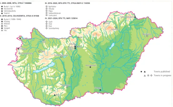
Nyírbátor, Óbuda, Pápa, Székesfehérvár and Szekszárd, while working on the pub- lication of the previously researched ones. From the second phase, the project could employ a part-time cartographer, and from the third phase a full-time researcher, Magdolna Szilágyi, coordinated the work of the team. 2021 saw the start of a fourth phase (NKFI/OTKA 135814) with four more cities, under István Tringli’s leadership, who has been co-editor of the series from the outset. The cities and towns recently taken on board are Győr, Ózd, Pest, and Szombathely (Fig. 2).
In the selection of towns, we have followed the principle of broad and relatively even geographical distribution within the country, and the proportionate coverage of a variety of morphological and historical town types. The nineteen atlases in the proj- ect so far represent eighteen cities and towns, including six royal towns: Buda (in two parts), Óbuda, Pest (all of these on the territory of modern-day Budapest), Sopron,
Figure 2 Hungarian Atlas of Historic Towns, atlases by project phases.
Cartography: Béla Nagy.
Szeged and Székesfehérvár; three bishops’ seats: Győr, Pécs, and Vác; eight market towns: Kecskemét, Kőszeg, Miskolc, Nyírbátor, Pápa, Sátoraljaújhely, Szekszárd, and Szombathely, while Ózd was an industrial center that had gained urban status as late as the nineteenth century. Given the fact that most royal towns and mining towns that used to belong to the Kingdom of Hungary up to 1920 are now on the territory of the neighbouring countries, therefore are potential subjects of their respective atlas series, the selection of the Hungarian “atlas towns” can be considered representative of the historical urban stock within the current political boundaries. Some of the towns changed their status over time: for instance, Óbuda was among the most important royal centers between the eleventh and the thirteenth centuries but lost its significance and became a market town owned from the fourteenth century by the queens, and later by private landlords, whereas Kőszeg was taken over by the king from a private landowner for much of the fourteenth century to become subjected to private land- owners again. The numerous seigneurial or market towns offer comparative examples for trans-European research on this important but often neglected town type.
In addition to the academic arguments described above, pragmatic consider- ations also play a role in the choices. The availability of a sufficient amount and quality of sources often poses a serious challenge, especially for the central part of Hungary, where the archives had been destroyed several times prior to the eigh- teenth century. Another important factor is the quality and extent of previous historical and archaeological research on the given localities, either in the form of town monographs or topographical works, as well as the possibility to involve local experts and institutions. However, even with a fair amount of preliminary research, it is always necessary to do more archival work and topographical surveys, and to collect the results of published and unpublished archaeological investigations to ensure the systematic character of the final products.
The fact that Hungary is a latecomer in the HTA project has presented us with both advantages and disadvantages. On the one hand, our published output is still limited compared to Bohemia and Poland, let alone Germany and Austria. On the other hand, we got involved with an already well-developed project and could learn from the methodological lessons that the other national projects had gone through.
While following all the above-described standards of the ICHT, we adopted a model that seemed most useful to us, a combination of the Austrian, Polish and Irish approaches. Regarding the source base, the Hungarian atlases are closely tied to the Austrian, Czech, Romanian, and partly to the Croatian and (for Lesser Poland) the Polish series, since the first series of cadastral surveys were prepared for these territo- ries in the framework of the Habsburg Monarchy. In Austrian scholarship, this survey is known as the Franziszeischer Kataster; however, on the territory east of the River Leitha, cadastral mapping did not start under Francis I (1792–1835) but only during
the reign of Franz Joseph (1849–1916).17 In Hungary, the work commenced at the country’s western border by royal order in 1849, and the surveys of the first towns, namely Sopron, Győr, and Kőszeg, were ready by 1856. The central and eastern parts were completed even later: for instance, Buda was surveyed as late as 1872, one year prior to its unification with Pest and Óbuda. However, since industrialization pro- ceeded slower than in Bohemia and the Austrian provinces, even surveys done in the second half of the nineteenth century preserved largely pre-industrial townscapes.
The sheets of the cadastral maps are pasted together for creating the base map, and redrawn at a scale of 1:2500, following the common standard and symbology.
The map of the town in its surrounding is taken—similarly to other East Central European series—from the first and second military surveys of the Habsburg Monarchy (prepared in 1763–1785 and 1819–1869, respectively) resized at a scale of 1:50,000. The growth phases of the given town are displayed on a series of maps showing each phase separately instead of overlaying them on a single map. This is a slight technical deviation from most other series, allowing for a clearer visualisa- tion. The maps listed above form “Part A” or the standard compulsory part of the cartographic material of each atlas. “Part B”, in addition, contains further thematic maps, displaying features of social topography or settlement morphology, depend- ing on the source basis and on other ongoing or recently completed locally rele- vant research projects. These may show the various jurisdictional or administrative units; the building time and height of individual buildings; the spatial distribution of various crafts or other occupational groups. They call the readers’ attention to various aspects of social uses of space. Finally, “Part C” of the cartographic material includes reproductions of selected historic maps, views, and partial surveys. The cartographic part is complemented by a textual one, consisting of a detailed histor- ical topographical study, and of comments to maps in “Part B” and “Part C”. They are complemented, following the excellent example of Irish atlases, by a detailed topographic gazetteer divided into thematic units. This part, which is probably the most work-intensive element of the atlases, offers an invaluable basis both for local historical and for larger-scale comparative research.
In our experience, the preparation and publication of the atlases gives a new impetus to topographical investigations connected to each city well beyond the con- crete editorial work. The discovery of new archaeological, cartographic and archival materials and the need for systematic and accurate visualisation of details usually lead to discovering new connections or patterns, and to raising new questions. The topo- graphic data summarized in the atlases serve as an important resource for local inhab- itants and administration. It has been particularly reassuring to see the engagement of architects and urban planners both in the preparation and the later use of the atlases.
17 Kain and Baigent, The Cadastral Map, 196–202.
The use of the atlases in research and plans for the future
With the publication of every new atlas, the question of “where next?” also arises. The issue is both about which town’s atlas should continue the series, and how to go ahead with the enterprise on the technical standards of our own times while remaining faithful to the roots and ensuring sustainability and comparability with earlier publi- cations. The Atlas Working Group is very much aware of the challenges and organizes workshops that discuss methodological issues connected to the editing and use of the atlases. Two of those workshops took place in Budapest, in 2012 and 2019, with the agenda of discussing the digital presentation of the atlases besides publishing them as printed volumes. The first discussion has resulted in setting up a Digital Initiative within the AWG, spearheaded by the Irish Historic Towns Atlas and the Institut für vergleichende Städtegeschichte in Münster. It has become clear that digital technol- ogy has much more to offer than simply preparing maps on the screen rather than on the drawing board. The second meeting that adjoined the General Assembly of the ICHT in Budapest between 19 and 21 September 2019 reported important method- ological progress by the various atlas teams in using GIS and related technologies in visualizing historical, archaeological and geographic data.
The ideal aim in my view would be to create a common digital portal where all the atlases could not only be reached via links to the respective “national” atlas series, but all of them could be studied together in a comparative way. So far, issues of copyright and the huge bulk of older atlases only available in printed format have raised high barriers that can only be surmounted with the participating countries’
common effort and by acquiring common resources to realize such plans. The results of hitherto pursued comparative projects should provide encouragement to work towards this goal. Let me close my report by referring to a few such examples.
The first and hitherto most rewarding enterprise was initiated by Anngret Simms, who raised the questions of how urban space was shaped by seigniorial power in the pre-industrial period and how such processes were reflected “on the ground”. The answers to these complex questions take us to the essence of compara- tive urban history, to the study of the ground plans of newly founded or redeveloped cities and towns—or of places that were contested or divided by different urban agents. The conference convened in Dublin to discuss these issues was followed by a volume entitled Lords and Towns, which not only contains case studies based on the different national atlas projects, but also offers essays on the symbolic meanings of town plans, as well as methodological surveys by archaeologists, art historians and historical geographers.18
18 Simms and Clarke, eds, Lords and Towns, especially studies by Dietrich Denecke, Matthias Untermann, and Jürgen Paul.
A more specific but chronologically and spatially broad-ranging topic on comparative urban morphology is the use of the grid plan as a means of developing or redeveloping urban sites. Many of the Polish atlases have been instrumental in approaching this topic, both from quantitative-metrological and historical points of view, aiming at the reconstruction of the ideal scheme of plot division at the time of the foundation or rearrangement of the town plan and its connection to the land allotment to the plots within the boundaries of the town.19 The atlas of Lviv also offers a valuable contribution to this theme,20 and many of the Czech towns (re)-founded in the second half of the thirteenth century, for instance Plzeň or České Budějovice, followed the same topographical scheme.21 Considering the medieval kingdom of Hungary from this point of view not only leads us to the example of Zagreb,22 but also to the question of why the grid plan was so rare in the Carpathian Basin compared to other parts of East Central Europe. Furthermore, it is worth asking to what extent Central Europe can be compared to the newly established colonial cities of the New World.23 Further directions of comparative research inspired by the Historic Towns Atlases led to the study of urban networks on the peripheries of medieval Europe: Anglo-Norman Meath and the Kulmerland, a region in modern-day Poland colonized by the Teutonic Order.24
The HTAs allow historians to address several extremely topical issues, such as resource management, and energy production and consumption in a long-term his- torical perspective. For instance, the topography of mills in the four towns included in the first Hungarian HTA project, Buda, Sopron, Kecskemét and Sátoraljaújhely, revealed different levels of complexity regarding the placement of watermills, as well as the combination of water energy with other sources of “powering the city”
via windmills, as well as human or animal power.25 A particularly urban phenom- enon was the use of moats for energy production, as well as for fish-breeding. The water circulating around many town defences, with its system of sluices and dams, was well suited for driving mills. How widespread this highly ecological solution was throughout medieval Europe was revealed by a survey based on the atlases and other topographical studies.26
19 Krasnowolski, “Muster urbanistischer Anlagen”; Krasnowolski, “Medieval Settlement.”
20 Dolynska and Kapral, “The Development of Lviv.”
21 Atlases edited by J. Anderle and V. Bůžek, respectively.
22 Bedenko, Zagrebacki Gradec; Slukan Altić, “The Medieval Planned Town,” 318–20.
23 Szende, “Town Foundations.”
24 Maleszka and Czaja, “The Urban Networks.”
25 Szende, “Mills and Towns.”
26 Vadas, “Economic Exploitation.”
Another equally relevant theme is the placement of hospitals, leper houses, and other institutions for the confinement of patients with contagious diseases. Besides a general interest in the history of social care and the Church, the current pan- demic calls attention to the importance of early isolation practices and the com- peting or complementary roles of municipal and state authorities in its regulation.
A survey carried out on a limited number of towns shows characteristic patterns in the choices of hospital locations.27 The Epidemic Urbanism project, with a strong global scope, may serve as an inspiration for intensifying the study of the interaction between epidemics and topographical change in the urban context.28
Likewise, town halls as centers of municipal governance—and the fact whether there was a town hall at all in a city or town—reveal much about the potentials and self-perception of a civic community. This thematic focus has already yielded important comparative studies concerning Central Europe in the framework of ICHT’s inquiries on the political functions of urban spaces.29
Finally, a possible next step in the analysis of the rich material assembled in the atlases may be to examine the long-term topographical development of cities and towns in a typological framework. Ordering the “atlas towns” into one or more func- tional types allows us to take stock of the research resources accumulated through the more than five decades of work on HTAs. Practically all historic towns repre- sent more than one type simultaneously or over time. A locality may have been, for instance, a river port, an industrial town, and a seat of ecclesiastic power at the same time. In fact, the more functions a town incorporated, the greater its centrality was.
This framework offers possibilities for comparative research both within and across town types. The next step that we propose is to test the explanatory potential of typology on selected town types through targeted topographical trial projects with the participation of several national atlas teams. This should include establishing a set of features within and across town types that enable systematic topographi- cal analysis and following change over time: emergence, development, alterations, or eventual decline. One must also keep in mind that towns underwent enormous transformation, and some of the typological attributions applied for the earlier peri- ods were no longer present in the nineteenth and twentieth centuries.30
I hope this report has shown that the often tedious and painstaking work on atlases does pay off. The broader we cast the net with preparing and publicizing new
27 Pauly, Peregrinorum; Szende, “Sag mir.”
28 Gharipour and DeClercq, eds, Epidemic Urbanism; see also the related YouTube channel:
https://www.youtube.com/channel/UCi40kwiBsOGgaxkqpTNx2Vg, accessed 4 August 2021.
29 See the thematic block “Town Halls and other Urban Spaces of Political Representation” in Czaja et al., eds, Political Functions; Opll, “Konstanz und Wandel.”
30 Szende and Szilágyi, “Town Typology”, 283–84.
atlases, the more reliable and exciting answers we can get not only to the “how” but also to the “why” questions. All regions and towns of Europe, on either side of the former Iron Curtain, can provide new data and arguments for urban morphological studies on a European scale.31 This is why it is so important that more countries join the project and more historians and geographers become acquainted with and use the already published atlases.
Literature
Bedenko, Vladimir. Zagrebački Gradec. Kuća i grad u srednjem vijeku [The Gradec of Zagreb. Houses and town in the Middle Ages]. Zagreb: Školska knjiga, 1989.
Clarke, Howard B. “Construction and Deconstruction. Components of an historic towns atlas methodology.” In Städteatlanten. Vier Jahrzehnten Atlasarbeit in Europa, edited by Wilfried Ehbrecht, 31–54. Städteforschung A 80. Cologne–
Weimar–Vienna: Böhlau, 2013.
Czaja, Roman, Zdzisław Noga, Martin Scheutz, and Ferdinand Opll, eds. Political Functions of Urban Spaces and Town Types through the Ages. Making Use of the Historic Towns Atlases in Europe. Cracow–Toruń–Vienna: Böhlau, 2019.
Dolynska, Mariana and Myron Kapral. “The Development of Lviv founded on Magdeburg Law between the 13thto 15th century.” In Ukrainian Historic Towns Atlas Vol. 1: Lviv, edited by Myron Kapral, 21–5. Lviv: Kartografia, 2014.
Eysymontt, Rafał and Mateusz Goliński, eds. Wrocław. Historical Atlas of Polish Towns, vol. IV Śląsk / Silesia, book 13, part 1. Wrocław: Instytut Archeologii i Etnologii PAN, 2017.
Gharipour, Mohammad and Caitlin DeClercq, eds. Epidemic Urbanism. How Contagious Diseases have Shaped Global Cities. Bristol: Intellect, 2021. doi.org/
10.1386/9781789384703
Kain, Roger J. P. and Elizabeth Baigent. The Cadastral Map in the Service of the State:
A History of Property Mapping. Chicago: University of Chicago Press, 1992. doi.
org/10.7208/chicago/9780226764634.001.0001
Krasnowolski, Bogusław. “Medieval Settlement Urban Designs in Małopolska.”
In European Cities of Magdeburg Law. Tradition, Heritage, Identity, edited by Anna Biedrzycka and Agnieszka Kutylak-Hapanowicz, 118–28. Cracow:
Muzeum Historyczne Miasta Krakowa, 2007.
Krasnowolski, Bogusław. “Muster urbanistischer Anlagen von Lokationsstädten in Kleinpolen. Forschungsstand, Methoden und Versuch einer Synthese.” In
31 Simms, “The Challenge,” 318–21. The Hungarian Atlas team is extremely grateful to Anngret Simms for her constant support and inspiration in setting up and carrying on our project.
Rechtsstadtgründungen im mittelalterlichen Polen, edited by Eduard Mühle, 275–322. Cologne–Vienna–Weimar: Böhlau, 2011. doi.org/10.7788/boehlau.
9783412213848.275
Lobel, Mary D., ed. Historic Towns: Maps and Plans of Towns and Cities in the British Isles, with Historical Commentaries, from Earliest Times to 1800. Oxford: Lovell Johns–Cook Hammond and Kell Organisation, 1969.
Maleszka, Anna and Roman Czaja. “The Urban Networks of Anglo-Norman Meath and the Teutonic Order’s Kulmerland: a Comparative Analysis.” Urban History (First View) 2021. doi.org/10.1017/S0963926821000250
Opll, Ferdinand. “Should the Historic Towns Atlases Continue beyond the First Ordnance Survey?” Accessed 3 August 2021. chrome-extension://efaidnbmn- nnibpcajpcglclefindmkaj/viewer.html?pdfurl=https%3A%2F%2Fwww.his- toriaurbium.org%2Fwp-content%2Fuploads%2F2017%2F11%2FOpll_Atlases- beyond-1900.pdf&clen=253935&chunk=true
Opll, Ferdinand. “Konstanz und Wandel. Die drei Wiener Rathäuser als Orte städ- tischer Identität.” Studien zur Wiener Geschichte. Jahrbuch des Vereins für Geschichte der Stadt Wien 77 (2021): 109–134.
Pauly, Michel. Peregrinorum, pauperum ac aliorum transeuntium receptaculum:
Hospitäler zwischen Maas und Rhein im Mittelalter. Stuttgart: Franz Steiner Verlag, 2007.
Rúzsás, Lajos and Jenő Szűcs. “A várostörténeti kutatás helyzete és feladatai”
[The State and Agenda of Urban History Research]. Az MTA II. Osztályának Közleményei 15 (1966): 5–68.
Simms, Anngret. “Paradigm Shift: from Town Foundation to Town Formation. The Scope of Historic Towns Atlases under the Crossfire of Archaeological Research.”
In Städteatlanten. Vier Jahrzehnten Atlasarbeit in Europa, edited by Wilfried Ehbrecht, 217–32. Städteforschung A 80. Cologne–Weimar–Vienna: Böhlau, 2013.
Simms, Anngret. “The Challenge of Comparative Urban History for the European Historic Towns Atlas Project.” In Political Functions of Urban Spaces and Town Types through the Ages, edited by Roman Czaja, Zdzisław Noga, Ferdinand Opll, and Martin Scheutz, 303–21. Cracow–Toruń–Vienna: Towarzystwo Naukowe w Toruniu – Böhlau, 2019.
Simms, Anngret. “The European Historic Towns Atlas Project: Origin and Potential.”
In Lords and Towns in Medieval Europe, edited by Anngret Simms and Howard B. Clarke, 13–32. Farnham: Ashgate, 2015. doi.org/10.4324/9781315250182-2 Simms, Anngret, and Howard B. Clarke, eds. Lords and Towns in Medieval Europe:
The European Historic Towns Atlas Project. Farnham: Ashgate, 2015.
Slukan Altić, Mirela. “The Medieval Planned Town in Croatia.” In Lords and Towns in Medieval Europe, edited by Anngret Simms and Howard B. Clarke, 305–20.
Farnham: Ashgate, 2015. doi.org/10.4324/9781315250182-15
Stoob, Heinz, ed. Deutscher Städteatlas. Lieferung I und II. Dortmund: Willy Größchen Verlag, 1973.
Szende, Katalin. “’Sag mir, wo die Spitäler sind…’ Zur Topographie mittelalterlicher Spitäler.” Mitteilungen des Instituts für Österreichische Geschichtsforschung 117 (2009): 137–146. doi.org/10.7767/miog.2009.117.jg.137
Szende, Katalin. “How Far Back? Challenges and Limitations of Cadastral Maps for the Study of Urban Form in Hungarian Towns.” In Städteatlanten. Vier Jahrzehnten Atlasarbeit in Europa, edited by Wilfried Ehbrecht, 153–190.
Städteforschung A 80. Cologne–Weimar–Vienna: Böhlau, 2013.
Szende, Katalin. “Mills and Towns: Textual Evidence and Cartographic Conjectures Regarding Hungarian Towns in the Pre-Industrial Period.” In Extra muros.
Vorstädtische Räume in Spätmittelalter und früher Neuzeit, edited by Guy Thewes and Martin Uhrmacher, 485–516. Städteforschung A 91. Cologne–
Vienna: Böhlau, 2019. doi.org/10.7788/9783412515164.485
Szende, Katalin. “Town Foundations in East Central Europe and the New World in a Comparative Perspective.” In Medieval East Central Europe in a Comparative Perspective. From Frontier Zones to Lands in Focus, edited by Gerhard Jaritz and Katalin Szende, 157–84. London: Routledge, 2016.
Szende, Katalin and Magdolna Szilágyi. “Town Typology in the Context of Historic Towns Atlases: a Target or a Tool?” In Political Functions of Urban Spaces and Town Types through the Ages, edited by Roman Czaja, Zdzisław Noga, Ferdinand Opll, and Martin Scheutz, 267–302. Cracow–Toruń–Vienna: Towarzystwo Naukowe w Toruniu – Böhlau, 2019.
Szűcs, Jenő. “The Three Historical Regions of Europe: An Outline.” Acta Historica Academiae Scientiarum Hungaricae 29, no. 2–4 (1983): 131–84.
Szűcs, Jenő. Nation und Geschichte. Studien. Budapest: Corvina, 1981.
Vadas, András. “Economic Exploitation of Urban Moats in Medieval Hungary with Special Regard to the Town of Prešov.” Mesto a dejiny 6, no. 2 (2017): 6–21.
© 2021 The Author(s).
This is an open-access article distributed under the terms of the Creative Commons Attribution-Non Commercial 4.0 International Licence (CC BY-NC 4.0).