Ser. 3. No. 6. 2018 |
ex Instituto Archaeologico Universitatis de Rolando Eötvös nominatae
DISSERT A TIONES ARCHAEOLO GICAE
Arch Diss 2018 3.6
D IS S E R T A T IO N E S A R C H A E O L O G IC A E
Dissertationes Archaeologicae
ex Instituto Archaeologico
Universitatis de Rolando Eötvös nominatae Ser. 3. No. 6.
Gabrieli Váczi quadragenario dedicatae
Budapest 2018
Dissertationes Archaeologicae ex Instituto Archaeologico Universitatis de Rolando Eötvös nominatae
Ser. 3. No. 6.
Editor-in-chief:
Dávid Bartus Editorial board:
László BartosieWicz László Borhy Zoltán Czajlik
István Feld Gábor Kalla
Pál Raczky Miklós Szabó Tivadar Vida
Technical editor:
Gábor Váczi Proofreading:
ZsóFia KondÉ Szilvia Bartus-Szöllősi
Aviable online at htt p://dissarch.elte.hu Contact: dissarch@btk.elte.hu
© Eötvös Loránd University, Institute of Archaeological Sciences Layout and cover design: Gábor Váczi
Budapest 2018
Zsolt Mester 9 In memoriam Jacques Tixier (1925–2018)
Articles
Katalin Sebők 13
On the possibilities of interpreting Neolithic pottery – Az újkőkori kerámia értelmezési lehetőségeiről
András Füzesi – Pál Raczky 43
Öcsöd-Kováshalom. Potscape of a Late Neolithic site in the Tisza region
Katalin Sebők – Norbert Faragó 147
Theory into practice: basic connections and stylistic affiliations of the Late Neolithic settlement at Pusztataskony-Ledence 1
Eszter Solnay 179
Early Copper Age Graves from Polgár-Nagy-Kasziba
László Gucsi – Nóra Szabó 217
Examination and possible interpretations of a Middle Bronze Age structured deposition
Kristóf Fülöp 287
Why is it so rare and random to find pyre sites? Two cremation experiments to understand the characteristics of pyre sites and their investigational possibilities
Gábor János Tarbay 313
“Looted Warriors” from Eastern Europe
Péter Mogyorós 361
Pre-Scythian burial in Tiszakürt
Szilvia Joháczi 371
A New Method in the Attribution? Attempts of the Employment of Geometric Morphometrics in the Attribution of Late Archaic Attic Lekythoi
Anita Benes 419 The Roman aqueduct of Brigetio
Lajos Juhász 441
A republican plated denarius from Aquincum
Barbara Hajdu 445
Terra sigillata from the territory of the civil town of Brigetio
Krisztina Hoppál – István Vida – Shinatria Adhityatama – Lu Yahui 461
‘All that glitters is not Roman’. Roman coins discovered in East Java, Indonesia.
A study on new data with an overview on other coins discovered beyond India
Field Reports
Zsolt Mester – Ferenc Cserpák – Norbert Faragó 493
Preliminary report on the excavation at Andornaktálya-Marinka in 2018
Kristóf Fülöp – Denisa M. Lönhardt – Nóra Szabó – Gábor Váczi 499 Preliminary report on the excavation of the site Tiszakürt-Zsilke-tanya
Bence Simon – Szilvia Joháczi – Zita Kis 515
Short report on a rescue excavation of a prehistoric and Árpádian Age site near Tura (Pest County, Hungary)
Zoltán Czajlik – Katalin Novinszki-Groma – László Rupnik – András Bödőcs – et al. 527 Archaeological investigations on the Süttő plateau in 2018
Dávid Bartus – László Borhy – Szilvia Joháczi – Emese Számadó 541 Short report on the excavations in the legionary fortress of Brigetio (2017–2018)
Bence Simon – Szilvia Joháczi 549
Short report on the rescue excavations in the Roman Age Barbaricum near Abony (Pest County, Hungary)
Szabolcs Balázs Nagy 557
Recent excavations at the medieval castle of Bánd
Rita Jeney 573 Lost Collection from a Lost River: Interpreting Sir Aurel Stein’s “Sarasvatī Tour”
in the History of South Asian Archaeology
István Vida 591
The Chronology of the Marcomannic-Sarmatian wars. The Danubian wars of Marcus Aurelius in the light of numismatics
Zsófia Masek 597
Settlement History of the Middle Tisza Region in the 4th–6th centuries AD.
According to the Evaluation of the Material from Rákóczifalva-Bagi-földek 5–8–8A sites
Alpár Dobos 621
Transformations of the human communities in the eastern part of the Carpathian Basin between the middle of the 5th and 7th century. Row-grave cemeteries in Transylvania, Partium and Banat
DissArch Ser. 3. No. 6. (2018) 597–619. DOI: 10.17204/dissarch.2018.597
Settlement History of the Middle Tisza Region in the 4
th–6
thcenturies AD
According to the Evaluation of the Material from Rákóczifalva- Bagi-földek 5–8–8A sites
Zsófia Masek
Institute of Archaeology Research Centre for the Humanities Hungarian Academy of Sciences
masekzso@gmail.com
Abstract
Abstract of PhD thesis submitted in 2018 to the Archaeology Doctoral Programme, Doctoral School of History, Eötvös Loránd University, Budapest under the supervision of Tivadar Vida.
Chronological and geographical frames
The main set of questions discussed in the thesis within historical aspects focuses on the 5th-century settlement network on the Great Hungarian Plain and on its chronological chang- es. The chronological frames given in the title are defined by the basic phases of the archaeo- logical material. Regarding the settlements, the number of distinctive chronological horizons is smaller than of the historical phases. These chronological horizons are usually defined as late Sarmatian–Hunnic and Gepidic. These horizons inevitably give broader archaeological frames including the end of the Sarmatian period, the Hunnic period and the Gepidic King- dom, lasting altogether from the late 4th until the mid-6th century.
The geographical borders are defined by the Middle Tisza mesoregion, the largest part of which lies in Jász-Nagykun-Szolnok County, Hungary. The western and northern borders of the investigated territory are adapted to the archaeological background. The main aim of the dissertation is to explore the central Sarmatian Barbaricum, and only additionally to make a slight overview of the independent research questions of the Sarmatian–Germanic borders in the Roman times. Therefore the northern border of the investigated territory on the Danube–
Tisza Interfluve is defined by the southern line of the linear dykes, namely the Csörsz-dyke (Devil’s Dyke) of the Great Hungarian Plain.
Main goals
The basis of the thesis is the archaeological material from the excavations of an early medieval site at Rákóczifalva-Bagi-földek and a Gepidic settlement at Tiszabura-Bónishát, both of which were conducted by the Eötvös Loránd University, the first one in 2006–2007, while the second in 2009. The Sarmatian and Gepidic periods of this region are relatively well-studied regarding the overall situation of the Great Hungarian Plain,1 thus the available information seemed to
1 H. Vaday 1989; Vaday – Horváth 2005; and many publications from János Cseh, esp. Cseh 1986; Cseh 1990;
Cseh 1991; Cseh 1993; Cseh 2004; Cseh 2015.
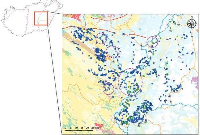
be sufficient to carry out an evaluation on a regional scale. As the evaluation continued, the importance of the material from Rákóczifalva and the role of the evaluation of its ceramic finds increased. However, getting more acquainted with the methodology and the actual research status of the investigated territory it became obvious that the settlement history can only be explored properly on a case-study level by choosing particular microregions (Fig. 1).
Methodology and sources of the settlement research
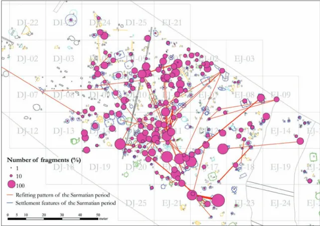
The evaluations of the ceramic finds from the settlements at Rákóczifalva and Tiszabura were prepared using a ‘classical’ typo-chronological approach. There are several similarly signi- ficant or even larger late Sarmatian-period assemblages available but only two – from Békés County – comparable to Rákóczifalva have been published so far.2 Therefore larger analyses of regional characteristics were very important. The Gepidic-period material from Rákóczi- falva is the largest such published assemblage. Beside the evaluation of the pottery, the thesis presents a structural analysis of the excavated settlements. In the assessment of the pottery and the settlement structure of Rákóczifalva special significance had the so-called refitting, e.g. the analysis of the complementary fragments of particular vessels collected from diffe- rent stratigraphical units. Altogether 138 such connections were traced; most of them can be connected to the destruction strata of the late Sarmatian–Hunnic-period settlement (Fig. 2).3 The structural analysis of the settlement from the Gepidic period, the separation of the phases
2 From Endrőd and Örménykút by Andrea Vaday: Vaday et al. 2011.
3 Masek 2015a.
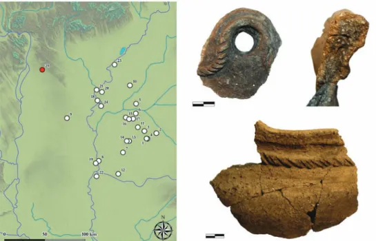
Fig. 1. The investigated territory in the Middle Tisza Region with the studied micro-regions (blue dots:
Sarmatian-period sites, green dots: Gepidic-period sites, red lines: Csörsz-dyke).
599 Settlement History of the Middle Tisza Region in the 4th–6th centuries AD
of sunken-floor features was prepared using multivariate statistics (Fig. 3).4 The relative chro- nology of the settlements gave a unique possibility in defining the chronological sequel of the settlement phases. The absolute chronology was based on the grave pottery from the late Sarmatian, Hunnic and Gepidic periods, supplemented with the analysis of the dating of small finds from the settlement features (antler combs and fibulae).
The analysis of the settlement was followed by the comparative evaluation of the ceramic material, focusing on the functional and stylistic aspects and their changes. This research was built on methods of symbolic functionalist analyses.5
Methodology and sources of the regional research
The investigated microregions of the Middle Tisza Region were created around archaeological sites of the Hunnic period (Fig. 1). Two of these microregions are located on the left bank of the Tisza River, in the vicinity of the sites of Rákóczifalva and Tiszabura evaluated in detail, where Hunnic-period graves were also found. Three other microregions are situated in the Danube–Tisza Interfluve with altogether three Hunnic period sites. The first one of them is a group of graves traditionally interpreted as of Alan character (Jászberény), another one is a grave find of Germanic character (Jánoshida) and the last one is a Hunnic metal cauldron (Törtel). The regional evaluation was prepared using different available tools and instruments
4 Masek 2015b.
5 Henrickson – Mcdonald 1983; Rice 1987, 249–252, 268–272; Hodder 1989.
Fig. 2. Rákóczifalva-Bagi-földek, Horizon 1, settlement unit 1, showing the results of the refitting of the ceramic material.
(archival sources, topographic surveys, field walks, aerial photography, and sedimentological data). Detailed conclusions of their usage can be drawn only by taking into consideration the settlement geography of the broader region. This part of the research was supplemented with an overview of the environmental-archaeological results of the Early Middle Ages in the Great Hungarian Plain.
Results of the settlement analysis
The largest part of the dissertation consists of the evaluation of the ceramic finds from the Rákóczifalva settlement. The amount of the analysed ceramic fragments reaches up to 18 819 sherds. Four ceramic horizons were separated, the second and the fourth of which were de- fined at first time on the settlements of the Great Hungarian Plain (Figs 4–5).
The relative chronological relation of the late Sarmatian–Hunnic- and the Gepidic-period pot- tery has been the subject of debate for quite a long time. At Rákóczifalva, as well as at other settlements, many mixed assemblages were excavated. Based on statistical analyses and the stratigraphy of the site, these ensembles did not present any signs of the continuous produc- tion or use of the Sarmatian pottery. What is more, the late Roman-time pottery from mixed contexts may be interpreted as residual ceramic material from later stratigraphic units (Fig. 6).
The first horizon includes the ceramic material of the local late Sarmatian–Hunnic period.
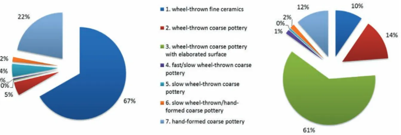
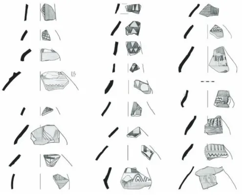
Comparing to the so far best published material from Békés and Csongrád counties, it shows distinctive regional differences. With a closer analysis, this can be confirmed also for the fine pottery. According to the general picture, the overwhelming majority of the material consists of untempered, wheel-thrown fine pottery of reduced as well as oxidised firing (Fig. 7). The fine pottery shows a great variety both of forms and rich smoothed-in ornamentation (Fig. 8), including also a significant quantity of Samian-ware imitations with stamped decoration (Fig. 9). The material presents similar proportions of the late Sarmatian fast and slow wheel- Fig. 3. Rákóczifalva-Bagi-földek, principal component analysis (PCA) of the sunken-floor features from Horizons 2–4, the main structure-types of the buildings are coloured.
601 Settlement History of the Middle Tisza Region in the 4th–6th centuries AD
thrown coarse pottery (5–5%). This balanced proportion is not characteristic for any of the published settlement material. The relatively large quantity of coarse pottery of Üllő type implies to trade contacts with the territory situated opposite Aquincum (Budapest).6 At the same time, the presence of the slow wheel-thrown, mica-tempered coarse wares refers to
6 This technological group is regarded as which could have been made with coiling technique and hand wheel (Istvánovits et al. 2011, 348–349; Kulcsár – Mérai 2011, 66–67), but the details of this research are yet un- published. This ware shows different technical characteristics as the so-called slow wheel-thrown material, therefore I kept the traditional expression as a technical term.
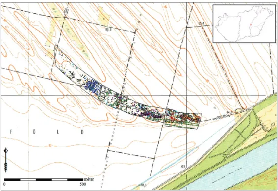
Fig. 4. Rákóczifalva-Bagi-földek 5–8–8A. Overview layout of the site and its geographical environment.
Fig. 5. Rákóczifalva-Bagi-földek 5–8–8A. Settlement horizons of the 4th–6th century AD (blue: Horizon 1, green: Horizons 2–4).
connections with the southern regions of the Great Hungarian Plain. The workshops of the latter wares produced also the so-called late Sarmatian cauldrons, which occur predominantly in the Trans-Tisza Region (Fig. 10). Besides these well identifiable groups, other types of both slow and fast wheel-thrown ceramic also appear in smaller amounts. These are most probably products of the local (regional), less known ceramic workshops.7 The quantity of the hand- formed pottery at the site is relatively high.
7 Recently, a similar tendency has been outlined in the southern parts of the Great Hungarian Plain too: Sós- kuti 2010, 176; Benedek et al. 2017, 155, 158–159.
Fig. 6. Rákóczifalva-Bagi-földek 5–8–8A. Ternary diagram of the stratigraphic units of mixed assem- blages and two examples for superposition between Sarmatian- (Horizon 1) and Gepidic-period (Horizon 3) features.
Fig. 7. Rákóczifalva-Bagi-földek 5–8–8A. Proportions of the main technological groups in Horizon 1 (left) and Horizons 2–4 (right).
603 Settlement History of the Middle Tisza Region in the 4th–6th centuries AD
Such a broad inner relation network of the ceramic can be most plausibly interpreted with the location of the site in the central region of the Barbaricum, on the Tisza bank, being thus over- lapped with the distribution zone of several more significant pottery workshops. The results of the evaluations also imply that the settlements in the northern part of the Great Hungarian Plain and Upper Tisza Region more-or-less contemporary with the Tiszaföldvár–Rákóczifal- va horizon8 possessed material culture similar to that of Tiszavasvári-Városföldje-Jegyző tag archaeological site.9
Horizon 1 can be observed at several settlement segments. The largest of them is an intensive- ly used, medium size settlement unit with dense, closed structure likely bearing above-surface constructions. The closure of the settlement can be interpreted – using refitting methods – as violent destruction (Figs 2, 6). The burnt debris of the settlement including human remains was levelled into the settlement features, most of all into the storage pits. The pottery from the debris thrown on one of these skeletal remains may be directly connected by refitting to the core of this activity area (Fig. 11). The sunken features existed at the same time cover the whole territory of the settlement unit. The closure of this unit can be dated to the D1/D2 rel- ative chronological phase (these two phases cannot be separated in the settlement materials of the Great Hungarian Plain).
8 Vaday 1994; Vaday 1997.
9 Istvánovits 1999.
Fig. 8. Rákóczifalva-Bagi-földek 5–8–8A, Horizon 1. Examples for jugs with smoothed-in decoration.
Fig. 9. Rákóczifalva-Bagi-földek 5–8–8A, Horizon 1. Stamped decorations of Samian-ware imitations.
The pottery of Horizon 2 at Rákóczifalva can be characterised by burnished jugs, a few large burnished vessels and by the so-called Leányfalu-type pot ware of late Roman nature (Fig. 12).
This production of the coarse ware shows much higher quality compared to the coarse pots of Horizon 1, and can be explained only by new technological transfer arrived from the Roman (Pannonian) territories. The variety of forms and the style of ornamentation of the fine jugs root in the late Sarmatian material but the technology of their production is lag behind it.
Fig. 10. Late Sarmatian–Hunnic-period cauldrons in the Hungarian Plain (white dots: cauldrons of slow wheel-thrown, mica-tempered coarse ware, red dot: cauldrons of Üllő-type gritty grey ware).
Fig. 11. Rákóczifalva-Bagi-földek, Horizon 1, core of settlement unit 1, examples for burnt debris and human remains levelled into storage pits.
605 Settlement History of the Middle Tisza Region in the 4th–6th centuries AD
Their style fits in the cultural complex of the Middle Danube Region of the Hunnic period.
Their analogies can be traced both in the late Sarmatian–Hunnic period and Hunnic-period grave pottery, as well as in the early Gepidic settlement at Battonya. This material can be dated to the D2/D3 phase of the Central European chronological system. This horizon cannot be undoubtedly identified as Gepidic because the grave pottery from the denser (“row”) cem- eteries of the Gepidic period does not contain any analogies for it. The closed assemblage of Horizon 2 can be traced at two segments of the settlement located eastward of the destroyed settlement unit of Horizon 1. Both segments consist of sunken-floor structures and pits, in- cluding bell-shaped storage pits. In this period we can assume arrival of new communities settled nearby an old habitation (Fig. 13).
Horizon 3 represents settlement material ‘classical’ for the Tisza Region in the Gepidic period.
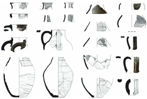
It consists of two, hardly separable phases. The development of the forms, some larger, more characteristic assemblages and the settlement structure altogether refer to that the decorative stamped pottery was not yet in use in the first phase of the horizon. Contrarily, in the second phase of the same horizon, the use of burnished pottery decreased while the presence of the stamped wares became common. Fragments of 65 stamped vessels were found at the site (this is the largest such, Gepidic-time assemblage). On the basis of the stamped motifs and the structure of ornamentation, most of the fine pottery can be connected to regional traditions characteristic of the vicinity of Szolnok and the lower part of the Körös River. Rarer stamped motifs and decoration arrangement refer to connections with the northern or southern parts of the Tisza riverside and even with Transdanubia. The wheel-thrown coarse pottery shows a great formal variety (Fig. 14). The appearance of large vessels, flaring in their upper part, a higher number of pots with articulated shoulders, and the general presence of strongly splayed Fig. 12. Rákóczifalva-Bagi-földek 5–8–8A, Horizon 2. Typology of fine pottery jugs.
channelled rims and combed decoration are not characteristic of any of the published materi- als. The technique and the assortment of the forms show that both the coarse pottery of Ho- rizon 1 and the Leányfalu-type wares of Horizon 2 influenced the development of this group.
Hand-formed pottery is represented in higher proportion among the material, including most of all so-called Suebian-type pots, the distribution of which is characteristic of Gepidic settle- ments of the northern part of the Great Hungarian Plain (Figs 7, 15). Their tempering, firing and forms differ from the Sarmatian-period hand-formed material. Changes observable in the traditions of hand-formed pottery unambiguously imply the arrival of new communities.
Fig. 13. Rákóczifalva-Bagi-földek 5–8–8A, Horizon 2.
Fig. 14. Rákóczifalva-Bagi-földek 5–8–8A, Horizon 3. Typology of fine and coarse pottery jugs.
607 Settlement History of the Middle Tisza Region in the 4th–6th centuries AD
The Gepidic-period settlement evolved from 5th-century settlement-cores. The appearance of the settlements of Horizons 2 and 3 is similar; no sharp rupture can be detected between them.
The sunken-floor dwellings of the settlement were dispersed composing rows or groups and divided by ditch-systems on a large territory. Changes in the economic background are also confirmed by the disappearance of bell-shaped storage pits by Horizon 3. Social isolation can be assumed in case of three huge, up to 30 m2 large, sunken-floor buildings, and at least one structure encircled by a ditch. Both mentioned cases can be dated to the 6th century by stamped pottery or a spouted jar. The Gepidic-time settlement is dating to the last third of the 5th and first half of the 6th century, while the stamped pottery might have appeared not earlier than the turn of the 6th century. According to the distribution of the stamped pottery, the ter- ritory of the 6th-century settlement might have reached at least 7 ha (Fig. 16).
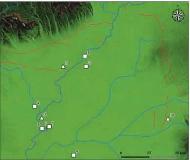
Fig. 15. Overview of sites with Gepidic-period Suebian-type hand-formed pots (square: settlements, triangle: cemeteries).
Fig. 16. Rákóczifalva-Bagi-földek 5–8–8A, Horizon 3. Scatter map of the Gepidic-period stamped pottery.
Fig. 17. Rákóczifalva-Bagi-földek 5–8–8A, Horizon 4. Typology of coarse pottery jugs.
Fig. 18. Rákóczifalva-Bagi-földek 5–8–8A. Typology of bowls in Horizon 2 (above), 3 (in the middle), and 4 (below).
609 Settlement History of the Middle Tisza Region in the 4th–6th centuries AD
The material of Horizon 4 can be hardly separated from that of Horizon 3 due to the continuous use of the settlement. It can be mentioned among its main characteristics that the untempered fine pottery almost completely disappears, and the use of Gepidic-period decorated ceramics is uncertain. The jugs are tempered, decorated with combed wavy lines (Fig. 17). The technology of the wheel-thrown tempered pottery declines. The tempering of the pots and their reductive firing also decay, the tempering is poorer, and the firing colour is lighter. Forms are larger with more elongated upper parts and wider bases. Shapes and decorations point to the Avar pottery (Fig. 18). The use of hand-formed ceramics continues. The material associated with Horizon 4 is significantly present in some particular structures of the building groups and in the eastern workshop segment all datable to the phase of Horizon 3. Several components of the ceramic material have no analogies, thus the dating is based predominantly on the relative chronology.
The use of the finds could have lasted until the Avar period, and according to some analogies from the Avar time, it can be dated up to the turn of the 7th century.
In the ceramic material of Horizon 3, several features can be observed that show direct con- nections with Horizon 1, missing at the same time from Horizon 2. The overarching connec- tions between Horizons 1 and 3 could have appeared even if the local population changed.
Local Roman-time traditions could have returned into the ceramic material indirectly. Differ- ent processes can be observed on the eastern part of the site where no fractures were docu- mented in the settlement structure but on the contrary, continuity of the habitation. Among different sunken-floor features, some workshop structures with cut-in hearths were concen- trated here (13 building, 14 hearths). Based on some traces of metalworking, these buildings may be interpreted as blacksmith or metal processing workshops. The pottery finds date them to Horizons 1, 3 and 4. This settlement unit seems to have been a long-live industrial location.
The features have only some sporadic late Sarmatian analogies. The construction of analogous buildings with cut-in hearths in the Gepidic period might have been possible only with direct transfer of the traditions that is with the continuity of the population.
Fig. 19. Tiszabura-Bónishát. Overview of the Gepidic-period settlement and its geographical environment.
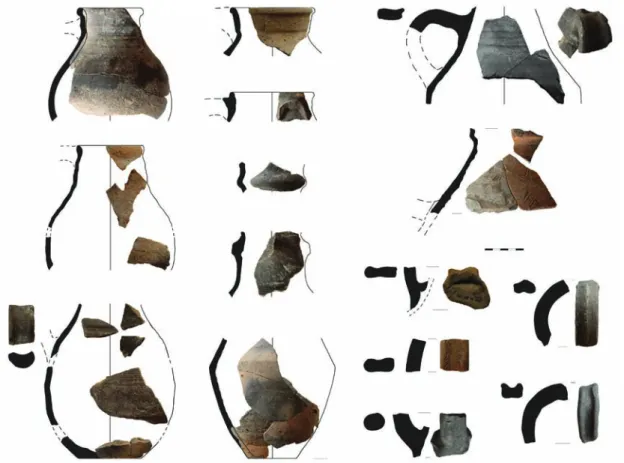
The evaluation of the smaller size Gepidic-period settlement at Tiszabura to a great extent helped and confirmed the conclusions drawn from the material of Rákóczifalva (Fig. 19). The homogeneous ceramic material implies to a relatively short lifespan of the site. The quantity of the fine pottery is relatively high, however, from the Gepidic-time fine wares, only the biconical vessels appear (Fig. 20). The shapes and the ornaments typical of the 6th century (pear-shaped vessels, stamped pottery) are absent from the site. The earlier date of the pottery production is supported by the articulated shoulders, the high number of strongly splayed channelled rims, and the grey firing colour with metallic gloss, the absence of the combed decoration and by the presence of relatively large pots. The shapes and the variety of tech- niques reflect a multi-rooted, undeveloped ceramic tradition. The material from Tiszabura is most probably contemporaneous with Horizon 3, phase 1 of Rákóczifalva. It can be dated to the second half of the 5th century, or as latest to the turn of the 6th century.
Changes of shapes and decorative style and in the ceramic material
There are significant differences between the variety of the shapes of the Sarmatian-period (Horizon 1) and Gepidic-period (Horizon 2–4) ceramic material. It can be assumed in the case of several Gepidic-period vessel-types that their origins root in the late Sarmatian pottery.
Despite this, changes of the pottery forms, simplification in the spectre of the formal types, and the decrease in the cubic capacity of the vessels can be clearly observed.
Apart from the pots, the Sarmatian material contains storage vessels and bowls in larger quan- tities. The Gepidic pottery material, however, was dominated by pots. The dominant functions in the Sarmatian material wares used for storage and dining but unusable for cooking became completely disremembered by the Gepidic time (Fig. 21). Some functions could have been replaced by pots to a smaller extent but due to specific shapes of the Sarmatian-time vessels, replacement can be rather excluded. The transformation of the shapes refers to changes in the dining culture, lifestyle and economic background. In the Sarmatian time, the decorated Fig. 20. Tiszabura-Bónishát. Typology of fine pottery and coarse-ware jugs.
611 Sett lement History of the Middle Tisza Region in the 4th–6th centuries AD
vessels could have been used for storing dry substances and liquids, for preparing food with- out fi re, for serving and dining, for preparing and stirring liquids and for their serving and consuming; and also for short-distance transportation.
In the Gepidic period, small or medium size vessels were decorated. As a result, specifi c fi ne pott ery was created, combining technology, shapes and ornamenting style. Th e function of this fi ne pott ery was predominantly consuming and serving drinks, and in case of small mugs presumably individual dining. Th e capacity and function together shift the accent from the community to an individual and could have served for strengthening personal identity and its communication (Fig. 22). Gepidic pott ery – in contrary to Sarmatian – does not refer to any signifi cance of communal traditions or rituals connected to meals or feasting, nor to any particular importance of the agriculture in the life of the sett lement.
A signifi cant disruption may be detected in the structure of the sett lement of Rákóczifalva as well as between the traditions of pott ery production of Horizons 1 and 2; however, stamped pott ery appeared only in the second phase of Horizon 3. Th e spread of stamped fi ne pott ery cannot be explained with a technical background because these techniques were well appli- cable also to burnished pott ery. Its appearance refl ects not a new population but rather a new decorative style and probable changes in the communication roles of the stylistic functions.
Fig. 21. Rákóczifalva-Bagi-földek. Changes in the main function types of the ceramic material.
Fig. 22. Rákóczifalva-Bagi-földek. Changes in capacity, shape and decorative style of the fi ne pott ery.
Results of the regional research
Although the environmental-archaeological analyses focus predominantly on other chrono- logical periods, still, some certain consequences can be drawn regarding the discussed top- ic. According to preliminary evaluations of rescue excavations and bore samples, the for- est-steppe character of the Great Hungarian Plain finally changed to anthropogenic grass steppe in the Roman time. The original forest zones were replaced by secondary, dispersed, sparse parklands. The size of the agricultural territory significantly increased compared to the prehistorical period. The human habitation, agricultural activity and deforestation altogether led to intensifying erosion and destruction of the soil. The dynamics of this process in the Roman time is yet unclear. The fact is that the sand lands of the Danube–Tisza Interfluve in the late Sarmatian period and later were subject to intensive sand movements. The reasons for this process are not known yet. The artificially opened vegetation remained on the Great Hungarian Plain after the Roman time, and the environment did not recover. However, the pollen samples unambiguously reflect a general decline of the human habitation and shrink- age of the agricultural activity.10
This environment corresponds to the climatic reconstructions. Based on the palaeoclimate graphs, valid for the Carpathian Basin, the average mean temperature and the levels of pre- cipitation changed excessively in different directions during the 4th–6th centuries. Between the warm and wet 4th, and the cold and wet 6th century we can observe a shorter drier period in the 5th century with gradually decreasing mean temperature. Contrary to the earlier scholarly views, the specifics of the 5th–6th-century habitation system cannot be explained by the dry climate. These climatic changes did influence the settlement, which can be supported by the settlement geography of the Middle Tisza Region.11
The small number of the Gepidic period settlements, in opposition to the vast quantity of the Sarmatian-period sites, is a commonplace in the Hungarian scholarly literature (Fig. 23). Sedi- mentological research and evaluation of the distance from the waters in case of the Sarmatian and Gepidic sites revealed that in both periods the inhabitants in general preferred similar reliefs. The main differences were observable in the flood areas. The Sarmatian sites emerged more often in the younger, lower situated floodplains of the late Holocene, and somewhat
10 Kustár – Sümegi 2012; Persaits et al. 2014.
11 Sümegi et al. 2009; Törőcsik et al. 2015, 218–237.
Fig. 23. Heat map of registered Sarmatian- (left) and Gepidic-period (right) settlements in the Tiszazug.
613 Settlement History of the Middle Tisza Region in the 4th–6th centuries AD
less frequently appeared on the higher flood areas of the early Holocene. Archaeological sites from the Gepidic period preferred higher situated floodplains of the early Holocene, on the silty soils. The Gepidic period reflects depletion in the landscape use. For some particular soil types, we have more chances to find a Gepidic archaeological site if there was also a Sarma- tian settlement. Gepidic-time settlements evolved with greater chances on Sarmatian sites that were situated closer to the water. The chances were even higher if the site was located on the riverside of the Tisza or Körös River. The lack of Gepidic-time archaeological sites on the right bank of the Tisza, as well as the significantly decreasing number of the sites toward the inner territory of the Trans-Tisza Region (Tiszántúl), cannot be satisfactorily explained by the geological or hydrological situation.
Results of the topographical research are as follows:
• The concentrations of the archaeological sites in the vicinity of Rákóczifalva and Szol- nok show a more-or-less similar situation. Gepidic sites regularly appear around the late Sarmatian–Hunnic ones, within a couple of hundred meters distance (Fig. 24).
Such settlement-clusters that were occupied in the 5th but abandoned in the 6th century turn up only on the right side of the Tisza. The archaeological sites of the 6th-century Gepidic settlement system emerged in the Roman cultural landscape, adapting to it but only on one side of the river.
• The continuity at the 4th
–
6th-century site complex excavated in the vicinity of Tisza- bura-Pusztataskony shows particular differences compared to Rákóczifalva. In case of the last one, the late Sarmatian–Hunnic layers are superimposed by Gepidic features.On the contrary, at Tiszabura the Gepidic-period habitation appeared beside a closed late Sarmatian-period settlement, encircled by a ditch. The Gepidic site is located on shifting sand, while the late Sarmatian settlement in an early Holocene floodplain (Fig. 25). The habitation continued on a relief more suitable for the general needs of the Gepidic time. In the neighbourhood, the Gepidic-period sites are concentrated mainly on the left side of the Tisza and are less common on the inner point bars. The settlement network is less studied but might have been organised similarly to that around Szolnok. There are two Germanic-like sites known from the right side of the Tisza but both of them are situated north of the southern line of the Csörsz-dyke (Kisköre-Pap-tanya, Kisköre-Gát).
• Although the exact location of a group of burials from the Hunnic period in the vi- cinity of Jászberény (Jászberény-Szőlő-dűlő) is unknown, it is assumable based on archive data that it might have been located beside a long-lived Sarmatian cemetery.
In any case, the Hunnic graves are situated within 2–3 km distance to the most im- portant Sarmatian archaeological sites of the region (Jászberény-Alsómuszáj, Jász- berény-Csege-lapos). These sites can be found on the southern side of the Zagyva River, on the edge of a loessial sandy plateau (Fig. 26). There are no known German- ic-period sites around Jászberény. It seems that the choice of the location for the 5th-century burials was in connection with the late Sarmatian settlement network and was embedded in that. The fairly emerging late Pleistocene relief situated close to the water was from all aspects suitable for the needs preferred by the population of the Gepidic period of the Tisza Region. The discontinuity of the settlement struc- ture cannot be explained by objective geographical circumstances.
• Th e precise coordinates of the female burial with a pair of eagle-headed footwear buckle (chronology: D2/D3) at Jánoshida-Káposztás-dűlő are also unknown but the approximate location of the site can be identifi ed. Th e fi eld walking carried out on the territory produced no evidence for Gepidic-time habitation. Th ere are two sig- nifi cant archaeological sites located within a 5 km distance from this one (Fig. 27):
Alatt yán-Tulát (male burial with a spear and a spatha, D1/D2) and Jászalsószent- györgy-Borsa-halom (a unique barrow-grave cemetery, C3–D1/D2). Th e relief is quite diff erent on the opposite sides of the Zagyva River. While the Sarmatian-time sites occur on both banks, the Hunnic-period site preferred an articulate location between meanders on loessial soils. Th e hydrological situation is fragmentarily reconstructa- ble. Even in this state of research, the position of the Hunnic-period burial can be interpreted taking the Sarmatian-time habitation into consideration, showing the importance of a small region located by a fordable section of the river. Th ere are no traces of habitation in this area in the 6th century, despite the seeming suitability of both sides of the Zagyva River.
• Th e site Czakó Mound near Törtel where a Hunnic cauldron was found in 1869 can be clearly identifi ed. Th e scarce information about the Sarmatian-time sites around the Czakó Mound is available almost exclusively from fi eld walking. Th ere are no fi nds refl ecting a possible Sarmatian-time elite. Based on negative fi eld walking results, no Sarmatian-period predecessors can be assumed on the site. Th e importance of the site itself as an ancient artifi cial mound seems to have been signifi cant, with a possible infrastructural meaning of the area. Th e appearance of the fi nds from the Hunnic period in the Danube-Tisza Interfl uve and in the Tisza Region might seem occasional, but their position can be easily explained in the context of the late Roman habitation.
Th e only contradictive example is the fi nd spot of the Törtel cauldron.
Fig. 24. Sarmatian- (blue) and Gepidic-period (green) sites in the vicinity of Rákóczifalva and Kengyel (square: sett lements, triangle: cemeteries).
615 Settlement History of the Middle Tisza Region in the 4th–6th centuries AD
Late antique continuity in the Tisza Region
Three 5th
–
6th-century continuity models can be outlined in the Middle Tisza Region.• On the left bank of the Tisza and in the Körös Region the settlement-clusters were partially continuous. The archaeological finds of the Hunnic period appear within such site (Rákóczifalva) or settlement-cluster (Tiszabura), which likewise present ma- terial of the Sarmatian and Gepidic periods. Despite the continuity of habitation, traces of sharp ruptures can be observed in the settlement network and the inner structure of the settlements. The transition from the Sarmatian to the Gepidic period seems to have been a gradual transformation. Its components, as well as the features of the continuity, could have differed from site to site.
• The Danube–Tisza Interfluve area is more characterised by scattered burial sites dating to the D2/D3 up to D3 Horizons. These sites generally reflect smaller social commu- nities. Their cultural texture is heterogeneous. Their common attribute is that none of them can be associated with the rich elite burials of the Hunnic period. In the Jászság the sites of the Hunnic period are located in vicinities of river crossings. The Jánoshida site is positioned beside an obvious late Sarmatian elite site (Jászalsószentgyörgy).
It seems that between the end of the 5th century and the Avar period these territories became depopulated. Most probably by this time, the late Roman settlement network that integrated the Hunnic-time sites ultimately collapsed.
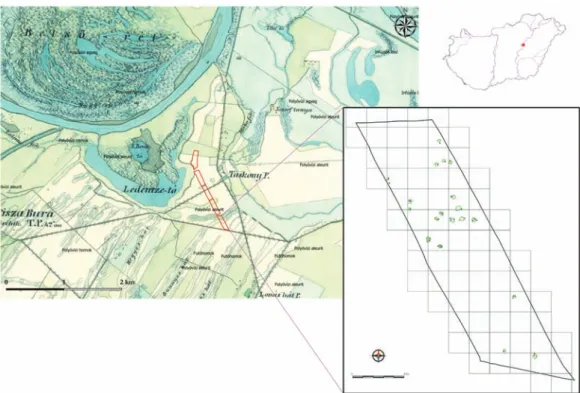
Fig. 25. Continuity in a settlement-cluster in the vicinity of Tiszabura-Pusztataskony. Sarmatian- (blue) and Gepidic-period (green) features and data from field survey; red dot: Hunnic-period single grave;
red lines: excavation borders.
• Th ere are no known Hunnic-period sites from the inner areas of the Trans-Tisza Region (Tiszántúl), however, Gepidic sites sporadically appear. Th e scientifi c evalua- tion of this region is hardly possible, we cannot even decide whether the small num- ber of Gepidic sites is just the result of the lack of research or not.
Th e absence of the archaeological sites in the Danube-Tisza Interfl uve and the inner areas of the Trans-Tisza Region cannot be fully explained by environmental changes. On the basis of current knowledge, the 5th-century habitation shows a fragmented, mosaic patt ern. Th e de- population of the landscape must have been a relatively long process ending in the last third or quarter of the 5th and the turn of the 6th century. Th e concentration of sett lement-clusters of the 6th century in the Tisza Region may have been interpreted as consequences of system- atic human decisions, being at the same time a result of the anthropogenic reactions to the environmental changes.
Based on results of the environmental archaeology and on the dense sett lement network, the great majority of the hinterland was partitioned in the Roman time. Th e Tisza Region most probably did not become completely desolated in the Hunnic period. Based on Anglo-Saxon models the explanation for the continuity of habitation between Sarmatian- and Gepidic-pe- riod sites on the territory of the fi rst model of continuity may be that the population of the Gepidic period sett led on the Roman time fi eld system. In cases of smaller hamlets evolved around earlier larger rural sett lements, we may deduce processes that are similar to what is reconstructed in the case of the West-European small communities sett led within the limits of large Roman latifundia.12
12 Unwin 1988; Oosthuizen 2010; Williamson 2010.
Fig. 26. Micro-regional survey in the vicinity of Jászberény. Red dot: the assumed location of the Hun- nic-period site Jászberény-Szőlő-dűlő, Varga-föld.
617 Sett lement History of the Middle Tisza Region in the 4th–6th centuries AD
Likewise based on Anglo-Saxon models, the system of sett lements in the Gepidic time can basically be interpreted as a colonisation model.13 Th is brings to the forefront the proximity of natural and human resources but does not necessarily require the quick emergence of larger central places. According to these models the new communities exploited not only the geographical peculiarities but also the assets of the Roman-time networks and cultural land- scape. For these prime-choice sett lement-territories, the continuity between the Roman peri- od and 5th
–
6th centuries seems to be more natural than for the areas of secondary habitation.Th e Gepidic-period sites that refl ect a higher number of inhabitants might have appeared in connection with the consolidation of the sett lement network. Th ere is no reason to directly interpret them as central places with strategic (military) signifi cance, and neither can we jus- tify existence of such features in the Middle Tisza Region. Th e distorted, uneven appearance of the Gepidic-period sett lement network may be the consequence of the very weak level of secondary colonisation on the Great Hungarian Plain, since the overall changes in the Avar period shift ed the process in a diff erent direction.
Th e archaeological sites of the Middle Tisza Region show that the scale of both depopulation and sett lement continuity is relative. In some areas, the Roman-time population might have survived and taken part in the transitional changes; while other places were occupied by a new elite or new farming population. Aside from assuming the destruction of parts of earlier sett lements, the transformation of their functions, the vanishing of archaeological sites and the appearance of new inhabitants in the Hunnic period, the impact of the Roman-time landscape and the partial continuity of the sett lement-network are still present. Some transfer of tech- nological know-how and the handicraft traditions can be traced. Th is, despite the high level of changes in the material culture and society also proves the partial continuity of the population.
13 Cowie – Blackmore 2008; Brookes 2010.
Fig. 27. Micro-regional survey in the vicinity of Jánoshida. Chronology of the highlighted sites: Jászalsó- szentgyörgy-Borsa-halom: C3–D1/D2, Alatt yán-Tulát: D1/D2, Jánoshida-Káposztás-dűlő: D2/D3.
References
Benedek, A. – Pópity, D. – Sóskuti, K. 2017: Késő szarmata teleprészlet a Makót elkerülő út területéről (M43, 29. lelőhely) (Late Sarmatian settlement part on the territoty of bypass at Makó). In:
T. Gábor, Sz. – Czukor, P. (Szerk.): Út(on) a kultúrák földjén. Az M43-as autópálya Szeged–
országhatár közötti szakasz régészeti feltárásai és hozzá kapcsolódó vizsgálatok. Szeged, 151–174.
Brookes, S. 2010: Population Ecology and Multiple Estate Formation: the Evidence of Eastern Kent. In:
Higham, N. J. – Ryan, M. J. (eds.): The Landscape Archaeology of Anglo-Saxon England. Pubica- tions of the Manchester Centre for Anglo-Saxon Studies 9. Woodbridge, 65–82.
Cowie, R. – Blackmore, L. 2008: Early and Middle Saxon rural settlement in the London region. MoLAS monograph 41. London.
Cseh, J. 1986: Adatok Kengyel környékének 5–6. századi települési viszonyaihoz (A gepida település- kutatás történetéhez). Beiträge zu den Siedlungsverhältnissen der Umgebung von Kengyel im 5.-6. Jh. (Zur Geschichte der gepidischen Siedlungsforschung). Archaeologiai Értesítő 111, 190–206.
Cseh, J. 1990: Gepida fazekaskemence Törökszentmiklóson (Gepidische Töpferofen in Törökszent- miklós). Archaeologiai Értesítő 117, 223–240.
Cseh, J. 1991: A kora népvándorlás kori (gepida) telep (The [Gepidic] settlement from the early Migra- tion period). In: Tálas L. – Madaras L. (szerk.): Régészeti ásatások Tiszafüred-Morotvaparton.
Szolnok Megyei Múzeumi Adattár 32. Szolnok, 157–225.
Cseh, J. 1993: Kengyel-Baghy-homok (Az 1990–1991. évi régészeti munkálatok naplója). (Függelék:
kora népvándorlás kori telepleletek Kengyel határából) (Kengyel-Baghy-homok[-sand]. Diary of the archeological works in the years 1990–1991. Appendix: Settlement-finds of the early migration period from the field of Kengyel). In: Szabó, L. (szerk.): Régészeti tanulmányok a Közép-Tisza vidékről. Tiszai Téka 4–5. Szolnok, 5–111.
Cseh. J. 2004: Szelevény-Schweiger-tanya. Egy VI. századi gepida település a Tiszazugban (Szele- veny-Sweiger-Homestead. A Gepid Settlement of the 6th century in the Tiszazug). Tisicum – A Jász-Nagykun-Szolnok megyei múzeumok évkönyve 14, 71–165.
Cseh, J. 2015: Hun kori és kora Meroving kori kiöntőcsöves kerámia kengyeli lelőhelyekről (az utób- bi kör edényeinek összelőfordulásával és szakirodalmával – 1898–2010). Tisicum – A Jász- Nagykun-Szolnok megyei múzeumok évkönyve 24, 57–70.
Henrickson, E. F. – McDonald, M. M. A. 1983: Ceramic Form and Function: An ethnographic search and an archaological application. American Anthropologist 85, 630–643.
Hodder, I. 1989: The Meanings of Things. Material Culture and Symbolic Expression. One World Archae- ology 6. London.
Istvánovits, E. 1999: Tiszavasvári-Városföldje, Jegyző-tag – A settlement of the 5th century. A Jósa András Múzeum Évkönyve 41, 173–254.
Istvánovits, E. – Kulcsár, V. – Mérai, D. 2011: Roman Age Barbarian Pottery Workshops in the Great Hungarian Plain. In: Bemmann, J. – Hegewisch, M. – Meyer, M. – Schmauder, M.
(Hrsg.): Drehscheibentöpferei im Barbaricum. Technologietransfer und Professionalisierung eines Handwerks am Rande des Römischen Imperiums. Akten der Internationalen Tagung in Bonn vom 11. bis 14. Juni 2009. Bonner Beiträge zur Vor- und Frühgeschichtlichen Archäologie 13. Bonn, 333–355.
Kustár, R. – Sümegi, P. 2012: Őskörnyezeti változások rekonstrukciója Harta környékén a 2002 – 2003. évi ásatások tükrében (Palaeoenvironmental changes inferred from results of excavations implemented in 2002 and 2003 near the settlement of Harta). In: Kreiter A. – Pető Á. – Tugya B. (eds): Környezet – Ember – Kultúra. A természettudományok és a régészet párbeszéde. Magyar Nemzeti Múzeum Nemzeti Örökségvédelmi Központ 2010. október 6–8-án megrendezett konfer- enciájának tanulmánykötete. Budapest, 107–114.
619 Settlement History of the Middle Tisza Region in the 4th–6th centuries AD
Kulcsár, V. – Mérai, D. 2011: Roman or Barbarian? Provincial Models in a Sarmatian Pottery Center on the Danube Frontier. In: De Sena, E. C. – Dobrzanska, H. (eds.): The Roman Empire and Beyond: Archaeological and Historical Research on the Romans and Native Cultures in Central Europe. British Archaeological Reports – International Series 2236. Oxford, 61–80.
Masek, Zs. 2015a: „Barbárok?” – A rákóczifalvi késő szarmata – hun kori pusztulási horizont értékelése (“Barbarians?” – Interpretation of the late Sarmatian-Hunnic period destruction horizon at Rákóczifalva). In: Balogh, Cs. – Major, B. (eds): Hadak útján XXIV. A népvándorláskor fiatal kutatóinak XXIV. konferenciája. Esztergom 2014. november 4–6. Studia ad Archaeologiam Paz- maniensiae – Magyar Őstörténeti Témacsoport Kiadványok 3.1. Budapest–Esztergom, 371–406.
Masek, Zs. 2015b: Száz gepida ház. A rákóczifalvi gepida település szerkezete (“Hundred Gepid Dwell- ings” – The Structure of the Gepid Settlement at Rákóczifalva). In: Balogh, Cs. – Major, B.
(eds): Hadak útján. A népvándorláskor fiatal kutatóinak XXIV. konferenciája. Studia ad Archae- ologiam Pazmaniensia 5 – Magyar Őstörténeti Témacsoport Kiadványok 3.1. Budapest–Eszter- gom, 407–445.
Oosthuizen, S. 2010: Medieval Field Systems and Settlement Nucleation: Common or Separate Ori- gins? In: Higham, N. J. – Ryan, M. J. (eds.): The Landscape Archaeology of Anglo-Saxon England. Pubications of the Manchester Centre for Anglo-Saxon Studies 9. Woodbridge, 107–131.
Persaits, G. – Sümegi, P. – Törőcsik, T. 2014: A solti Tételhegy környezettörténete pollen- és fitolitele- mzés alapján. The environmental history of Solt–Tételhegy based on pollen and phytolith analy- ses. In: Somogyvári, Á. – Szentpéteri, J. – V. Székely, Gy. (eds.): Településtörténeti kutatások.
Solt–Tételhegy, Kiskunfélegyháza–Amler-bánya. Archaeologia Cumanica 3. Kecskemét, 159–170.
Rice, P. M. 1987: Pottery Analysis: A Sourcebook. Chicago.
Sóskuti, K. 2010: Szarmata településleletek egy gázszállító vezeték Csongrád megyei szakaszáról Pusztaszertől Algyőig (Sarmatische Siedlungsfunde auf der Trasse einer Gasfernleitung durch das Komitat Csongrád von Pusztaszer bis Algyő). In: Lőrinczy, G. (ed.): Pusztaszertől Algyőig.
Régészeti lelőhelyek és leletek egy gázvezeték nyomvonalának Csongrád megyei szakaszán.
A Móra Ferenc Múzeum Évkönyve – Monumenta Archaeologica II. Szeged, 171–193.
Sümegi, P. – Jakab, G. – Majkut, P. – Törőcsik, T. – Zatykó, Cs. 2009: Middle Age paleoecological and paleoclimatological reconstruction in the Carpathian Basin. Időjárás 113, 265–298.
Törőcsik, T. – Náfrádi, K. – Sümegi, P. 2015 (eds.): Komplex archaeobotanika (Complex archaeobo- tanics). Szeged.
Unwin, T. 1988: Towards a model of Anglo-Scandinavian rural settlement in England. In: Hooke, D.
(ed.): Anglo-Saxon Settlements. Oxford, 75–98.
H. Vaday, A. 1989: Die sarmatischen Denkmäler des Komitats Szolnok. Ein Beitrag zur Archäologie und Geschichte des sarmatischen Barbaricums. Antaeus 17–18, Budapest.
Vaday, A. 1994: Late Sarmatian graves and their connections within the Great Hungarian Plain. Slov- enská Archeológia 42, 105–124.
Vaday, A. 1997: Atipikus szarmata telepjelenség a Kompolt- Kistéri tanya 15. lelőhelyén (Eine atypi- sche sarmatische Siedlungserscheinung auf dem Fundort Kompolt, Kistéri-Gehöft 15). Agria – Az Egri Múzeum Évkönyve 33, 77–107.
Vaday, A. – Horváth, F. 2005: Corpus der römischen Funde im europäischen Barbaricum. Ungarn, Band 1, Komitat Szolnok. Budapest.
Vaday, A – Jankovich, B. D. – Kovács, L. 2011: Archaeological Investigations in County Békés 1986–
1992. Varia Archaeologica Hungarica 25. Budapest.
Williamson, T. 2010: The Environmental Contexts of Anglo-Saxon Settlement. In: Higham, N. J. – Ryan, M. J. (eds.): The Landscape Archaeology of Anglo-Saxon England. Pubications of the Man- chester Centre for Anglo-Saxon Studies 9. Woodbridge, 133–155.