INTRODUCTION
Highlighted challenges of landscape management and urban policy are land use and urban sprawl manage- ment (EEA 2016, EEA 2007). Import- ant concerns occurred from the aspect of landscape architecture, like sustai- nability, disproportional land take, loss of natural habitats, as well as traditio- nal land use (Artmann et al. 2019; Ant- rop 2004). Nevertheless, the concept of urban sprawl is commonly used, seve- ral qualitative and quantitative definiti- ons exist (some examples: Steurer and Bayr 2020; Luc-Normand 2020; Szirmai 2011; Ewing 2008; Galster et al. 2001) it is hard to define precisely (Tsai 2005).
Egidi et al. (2020: 4) highlights “sprawl still remains a mixed morphological and
functional issue, e.g., in terms of hou- sing, land-use, fragmentation, and con- fusion of landscape characters” refer- ring to Colantoni et al. (2015) and Di Feliciantonio and Salvati (2014).
The analyses of different spatial patterns or morphological distribution of urban sprawl is a core topic of urban planning (Angel et al. 2010; Schneider and Woodcock 2008; Schwarz, 2010;
Galster et al. 2001). Compact city, as an objective for urban planning is on the political agenda, to foster organic growth of urban areas and fill the gaps within the urban tissue (CEC 1990, 1996;
Kasanko et al. 2005; Batty et al. 2003).
In the literature, the most influenced territories are in focus: the central city and its settlement network (Szirmai 2011) and also the periphery, edge, peri
urban territories (Lennert 2018; Csemez 2008; Antrop 2004). The definitions of functional urban area (FUA) (OECD 2013;
2012) or urban settlement groups (KSH 2014) are integrated into the interna- tional and national discussions and the statistical systems as well. FUA regions are determined on the basis of population density and conti- nuity of integration. The definition of urban settlement group, just like agglomeration and agglomerating area are used in Hungarian context, deter- mined by multiple indicators by KSH Inostroza et al. (2013) distinguish three main spatial pattern infill, axial and isolated development. By all new devel- opment, that is taking place in adja- cency with the pre-existing urban tissue, infilling increase compactness,
axial growth follows the main devel- opment axis, and is strongly deter- mined by infrastructure. No doubt, spatial analyses of urban sprawl needs to be the basis of urban planning an overall review from this respect has not appeared yet from Hungary.
The motivation for compact urban planning was missing from the regu- latory environment until 2019 (Act CXXXIX of on Land Use Framework Plan of Hungary and Priority Areas, OTrT).
The country-level studies focus on the Budapest agglomeration (for example Lennert et al. 2020; Kovács et al. 2019;
Cegielska et al. 2018; Egyedné Gergely 2014; Schuchmann 2013; Tosics 1998).
However, on the situation of smaller towns, only short term or case-focused studies were born (Hoyk et al. 2020).
TENDENCIES AND SPATIAL PATTERN
OF URBAN GROWTH IN THE CATCHMENT AREA OF HUNGARIAN MIDDLE CITIES
BETWEEN 1990-2018
A VÁROSI NÖVEKEDÉS TRENDJEI
ÉS MORFOLÓGIÁJA MAGYARORSZÁGI KÖZÉPVÁROSOK VONZÁSKÖRZETÉBEN 1990 ÉS 2018 KÖZÖTT
HTTPS://DOI.ORG/
10.36249/57.2 SZERZŐ / BY: IVÁNCSICS VERA,
FILEPNÉ KOVÁCS KRISZTINA
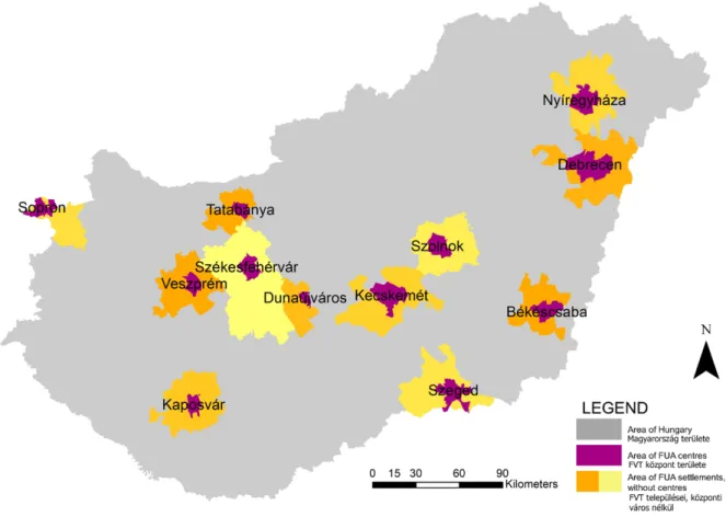
1. ábra/Fig. 1:
A vizsgált FVT-k területe / The area of the analysed FUAs
1
1 FUA regions are determined on the basis of population density and continu- ity of integration according to interna- tionally accepted methodology (OECD 2013). According to the Hungarian met- hodology, the agglomeration linkage is determined by 10 indicators by KSH (2014). Urban settlement group means a tighter connection between the cent- ral town and settlements around than a neighbourhood relation, but a weaker connection than agglomeration or agglo- meration area.
The present paper explores the trends of spatial growth of func- tional urban area (FUA) of 12 second- tier Hungarian towns since 1990.
METHODS
The Corine Land Use Change (CLC CHA) database – initiated by European Commission from 1990, 2000, 2006, 2012 and 2018 – serves as the basis of the research. The CLC CHA data was recalculated per analysed areas and visualized to 12 second-tier Hungarian towns and its functional urban areas (FUA): Békéscsaba, Debrecen, Dunaújváros, Kaposvár, Kecskemét, Nyíregyháza, Sopron, Szeged, Székesfe- hérvár, Szolnok, Tatabánya, Veszprém (Fig. 1,2). The area of selected regions falls between 37,320 ha (Tatabánya FUA) and 165,200 ha (Székesfehérvár FUA). The population ranges between 86,757 inhabitants (Dunaújváros FUA) and 331,648 inhabitants (Debrecen FUA) (Fig. 2), as comparison Buda- pest agglomeration covers 253,800 ha and has 2.5 million inhabitants (2014).
The selection on such areas, where the FUA category and urban settlement groups parallel exists according to
delineation of Urban Atlas (2012), OECD (2013) and KSH (2014).1 The analyses of spatial pattern of artificial areas were categorised according to the distri- bution of areas between central town and other FUA settlements. An overview was also made according to the cate- gories of Inostroza et al. (2013): infill, axial and isolated development.
The Geographical Information Systems (GIS) – ArcMap software 10.2.2. was used to delineate, visualise and calculate the different land use change categories.
Based on the Corine land use nomen- clature, several categories were aggre- gated and grouped in order to high- light the urban sprawl (Table 1).
The direction of the changes was also detected. If the given area stayed within the category of three main land use patterns (Artificial, Agricultural and Natural). In order to determine the characteristics of urban sprawl and find explanation for the trends, artificial surfaces were divided into 5 further cate- gories: (i) urban fabric, (ii) industrial and commercial units, (iii) transport units, (iv) mine sites, (v) urban green areas.
The spatial pattern of new artificial areas between 1990–2018 is compared to the existing urban fabric, visualised according to Urban Atlas 2012 Database
(Artificial surfaces). Unfortunately, the Urban Atlas 2018 Database was not available for all analysed settlements.
RESULTS Major changes
Firstly, changes were analysed to reveal the difference between the three main categories (Table 2, Fig. 2). However, the role of new agricultural areas are marginal, the ratio of new natural areas show territorial inequalities. It is also in accordance with the FUAs, where changes are significant: Kecskemét, Szeged, Nyíregyháza and Debrecen.
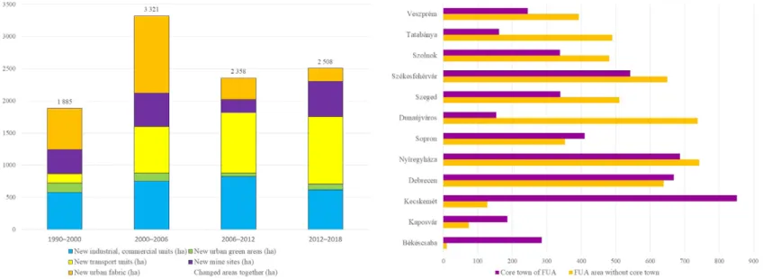
Appearance of new artificial surfaces (Fig. 3) is balanced in the examined regions, the values fall between 259 and 1458 hectares between 1990 and 2018.
Large areas turned into artificial surfaces in the following FUAs: Dunaújváros, Kecskemét, Székesfehérvár, Debrecen and Nyíregyháza; marginal growth is experienced in this respect in Kaposvár and Békéscsaba FUAs. In different time periods, the largest area of artificial surfaces appeared in Tatabánya FUA between 1990–2000, in Nyíregyháza FUA between 2000–2006 and 2006-2012 and in Debrecen FUA between 2012–2018.
Also, the lowest area of artificial surfaces appeared in Dunaújváros FUA between 1990–2000, in Kaposvár FUA between 2000–2006 and in Debrecen FUA between 2006–2012 and 2012–2018.
The intensity of new artificial surfaces is varying within the country.
In the period after the transition (1990–
2000), the newly appearing arti- ficial surfaces were dominant in the Western Region, while the Eastern part of Hungary joined after 2000 to this trend with Nyíregyháza, Szeged and Debrecen FUAs. However, some FUAs (Békéscsaba, Kaposvár) are lagging behind the dominant ones from both parts of the country.
Within the category of artificial surfaces (Fig. 3–5) between 1990 and 2018, i.e. in the whole examined period new industrial sites were considered remarkable in the Tata- bánya, the Nyíregyháza, the Székes- fehérvár and the Kecskemét FUAs with the change affected more than 300 hectares. Also, with less than 50 hectares change marked as marginal in the Békéscsaba and the Kaposvár FUAs. In the Kecskemét FUA, new industrial sites give 47% of all new artificial surfaces, while in the Tata- bánya FUA the same amounts to 49%.
Code
Corine nomenclature Simplification and terms in this study
Class 1 Class 2 Class 3 Main
categories Further categories 1.1.1
Artificial surfaces
Urban fabric
Continuous urban fabric
Artificial surfaces
Urban fabric
1.1.2 Discontinuous urban fabric
1.2.1
Industrial, commercial and Transport units
Industrial and commercial units
Industrial and commercial units (abbr.
industrial units)
1.2.2 Road and rail network and
associated lands
Transport units
1.2.3 Port areas
1.2.4 Airports
1.3.1
Mine, dump and construction sites
Mineral extraction sites
Mine, dump sites (abbr. mine sites)
1.3.2 Dump sites
1.3.3 Construction sites
Manually categorised according to the satellite photo from Google Earth 2020.
1.4.1 Artificial, non-agricultural
vegetated area
Green urban areas Artificial, non-agricultural vegetated area (abbr. urban green areas)
1.4.2 Sport and leisure facilities
2. Agricultural areas … …
Agricultural areas 3 Forest and semi
natural areas … … Natural, semi
natural areas (abbr. natural areas)
4 Wetlands … …
5 Water bodies … …
1. táblázat/
Table 1: Az elemzés során alkalmazott felszínborítási kategóriák a Corine kódok alapján nomenclature (Bossard et al. 2000;
Heymann et al. 1994) / The applied land use categories of the
analyses, based on Corine nomenclature (Bossard et al. 2000;
Heymann et al. 1994) 2. ábra/Fig. 2: FVT területe és népessége / The centre, the area and the population of analysed FUAs (forrás/source:
urban atlas 2012;
területi atlasz ksh, 2020 / urbanatlas 2012;
detailedgazetteerofhungary fromksh, 2020) 3. ábra/Fig. 3: Az új területek a teljes FVT terület százalékában 1990 és 2018 között / Newly appeared areas in ratio of whole FUA area between 1990 and 2018
1 2 3
New transportation units are dominant in the following FUAs:
Székesfehérvár, Szolnok, Debrecen, Dunaújváros, Nyíregyháza. In the Nyíregyháza FUA, 52% of new arti- ficial surfaces fall into this category with 742.5 hectares, while in the
Dunaújváros FUA the same value is 76%.
New mine sites appeared to a larger extent in the Szeged, Szolnok, Székes- fehérvár FUAs, with more than 200 hectares, and to a smaller extent in the Sopron, Kaposvár, Kecskemét FUAs. In the Békéscsaba FUA, the area of new mine sites did not grow after 2012, but still this category gives 48% all the new artificial surfaces in the whole period. In parallel, in the Dunaújváros FUA, no new mine sites were opened during the whole period.
New urban fabric is dominant in the following FUAs, with over 200 hectares: Nyíregyháza, Kecskemét, Szeged, Sopron (60% of all new arti- ficial surface), Debrecen (42% of all new artificial surface). In the Békéscsaba and Dunaújváros FUAs less than 50 hectares of new urban fabric appeared.
New urban green areas are not so dominant within artificial surfaces. A remarkable change was detected in Veszprém, with 111.6 hectares, but in
several FUAs no new urban green areas appeared: Békéscsaba, Dunaújváros, Szolnok, Nyíregyháza, Kecskemét.
Spatial pattern of new artificial surfaces
The visual analyses of spatial pattern of new artificial surfaces is made within the area of central towns, also within the area of the whole FUA. Among the analysed areas, different limitations can be detected that may influence the spatial distri- bution of new artificial areas.
• Country border that is a strong barrier of FUA delineation as well. It is very spectacular in the case of Sopron, but a section of the border of the FUA is the country border at the Szeged and Debrecen FUAs as well.
• Relief, like the neighbourhood of the River Danube (Tatabánya,
Dunaújváros) or the River Tisza (Szeged, Szolnok) or hills (Sopron, Kaposvár, Tatabánya, Veszprém) or plain (Szeged, Debrecen, Nyíregyháza, Szolnok, Békéscsaba) also influences development.
• Local characteristics, like settlement structure, traditional land use pat- terns, situation of transportation network (Cieslak et al. 2019) should
also be taken into consideration.
The distribution of new artificial surfaces between the core town and agglomer- ation area around it (FUA area without core town) gives an overview about the centralised or scattered nature of urban sprawl (Fig. 6, Table 2). According to the results three group is seen:
• New artificial surfaces are central- ised to the administrative area of core town: Békéscsaba, Kaposvár,
Kecskemét
• New artificial surfaces are scattered in the settlements of FUA area:
Dunaújváros, Szeged, Székesfehérvár, Szolnok, Tatabánya, Veszprém
• Balanced appearance between the areas: Debrecen, Nyíregyháza, Sopron
The spatial pattern of new artificial surfaces shows different distribution in the regions. To highlight further char- acteristics that are visible from the map analyses (Fig. 7,8; Table 2), the cate- gories of Inostroza et al. (2013) were applied: infill, axial and isolated.
The most important difference is in the concentration that can caused by geographical and morphological reasons. It is clear, for example, that the new urban fabric strongly linked to the existing urban fabric. Also, the
focus points of development are visible, the new automobile investment in the Kecskemét FUA. An axial development in the Dunaújváros, Nyíregyháza, Székes- fehérvár or Szeged FUAs are indicated, because of the existence of the motorway network or a geographical barrier, like Danube. Also, in the case of Székes- fehérvár and Veszprém, a horizontal (West–East) line (parallel to motorway 8) is dominant. In the case of Tatabánya, a vertical (North–South) line is charac- teristic thanks to the most important motorway (M1) line. The results are in accordance of former studies (Iváncsics and Filepné 2019a; 2019b).
CONCLUSION
Urban sprawl in Hungary shows strong regional differences, the nature of the process within FUA regions can be easily followed based on the results.
The most important findings empha- sise the temporal concentration of the new urban fabric to 1990 and 2006, that shows that suburbanisation process started explosively after 1990 – after the decades of socialism with controlled movement of people, and later slowed down (Enyedi, 2016) or was slightly
modified. The Sopron FUA at the western border is an exception, though, where the geographical location and exist- ence of iron curtain strongly modi- fies this trend. This trend is similar to Polish examples (Cieslak et al. 2019).
Important motivating forces for the emerging artificial surfaces are the growth of urban fabric (housing), industrial sites (economic devel- opment) and transportation units (motorway constructions).
Another regional characteristic is that the first wave of industrial renewal reached the western regions, and the eastern part of Hungary joined in only later. The results highlight the impor- tance of motorway constructions in urban sprawl, which is in accordance with Eastern European tendencies (Feranec et al. 2017). The spatial pattern of new arti- ficial areas also shows correlation with the motorway network, influences the axial development. However, in some cases the dominant role of the central town is visible, developments are scat- tered in most of the FUAs. The spatial pattern of urban sprawl is also influ- enced by settlement development char- acteristics and history. As we highlighted in the results, Kecskemét had a diffuse pattern of new artificial areas (except 4. ábra/Fig. 4:
Az FVT-k területén az új mesterséges felszín a vizsgált
peródusokban / The new artificial surfaces during the examined periods in FUA areas.
The size of the bubble indicates the share of the changed areas to the FUA area
5. ábra/Fig. 5:
Az új mesterséges felszín a 12 FVT területén a vizsgált peródusokban / New artificial surfaces in all 12 FUAs in the examined periods
6. ábra/Fig. 6:
Az új mesterszége felszín megoszlása (ha) a központi város
és az FVT területén 1990 és 2018 között / Distribution of new artificial surfaces (ha) between the core town and FUA area without core town between 1990 and 2018
4 5 6
new urban fabric). This is due to the tradi- tional urban pattern of specific regions of the Hungarian Great Plain, where some- times 40-70% of the population of the settlement live in the outskirts in home- steads (Sikos and Beluszky 2008).
It is important to consider the limi- tations of the Corine database, such as errors due to scale, size of the smallest mapping unit, generalization rules (Diaz-Pacheco and Gutiérrez 2014; Mari 2010). For further analyses of spatial pattern it is need to do apply further existing calculations and methodol- ogies. Also, overlapping areas are not detected within the category of arti- ficial surfaces; however, within the category of new agricultural and natural areas overlapping polygons may occur.
The strong differences of urban sprawl can be explained by the late integration of the idea of “compact city” (Artmann et al.
2019), as well as by a strong influence of municipal policy making. However, legis- lation has an important role to control and manage urban sprawl (Geneletti et
al. 2017; Ewing 2008; Antrop 2004; Allen 2003), but in Hungary national guidance for a compact city structure in the regu- latory framework was pronounced only after 2018 with the Act CXXXIX of 2018 on Land Use Framework Plan of Hungary and Priority Areas. Our work draws attention to the importance of legislation both at the national and the regional levels. At the regional level, there is a relative freedom of municipalities, and they are able to influence the nature of urban sprawl with several assets, like the identification and infrastructural development of areas for urban living or industry, or long term strategic planning through land use plans (Iváncsics and Filepné Kovács 2019a; Egyedné Gergely 2014; Ricz et al. 2009). In the majority of the analysed city’s strategies there is the objective of compact city development.
However, these assets are just for the administrative area of the core town, they are missing from the regional perspective, due to the relatively weak role of counties or other regional public bodies. ◉ 2. táblázat/
Table 2: Az új mesterséges felszín területi
elhelyezkedése 1990 és 2018 között / The different spatial distribution of new artificial surfaces between 1990 and 2018
7 ábra/Fig. 7:
A központi városok területén az új felszínek elhelyezkedése 1990–2018 / Spatial distribution of new artificial surfaces in central towns between 1990–2018
2
7
Centralised or scattered or balanced
Infill or axial or
isolated Remarks
Békéscsaba Centralised Infill, isolated Mining sites and transportation units are isolated Kaposvár Centralised Infill New developments are connected to existing ones Kecskemét Centralised Infill Except isolated investment at the South part of the town
Debrecen Balanced Infill and axial
Regarding new urban living areas infill, north-south axial development is seen by new industrial and transportation areas Nyíregyháza Balanced Infill, axial, isolated Infill by new urban fabric areas, axial by transportation area, isolated
by industrial and some new urban fabric areas
Sopron Balanced Infill, isolated
infill regarding new urban fabric areas, in other FUA settlements isolated
Dunaújváros Scattered Axial
the direction of axial development is influenced by the north-south direction thanks to River Danube. Some new urban fabric areas infill the existing artificial surfaces.
Szeged Scattered Axial, infill
Industry strongly linked to road network. Infill regarding new urban fabric.
Székesfehérvár Scattered Axial, isolated Industry strongly linked to road network. Isolated regarding new urban fabric.
Szolnok Scattered Axial, isolated
East-west axis is seen according to road network, in FUA around some isolated development.
Tatabánya Scattered Axial The most important motorway (M1) influences the spatial pattern of new artificial surfaces.
Veszprém Scattered Axial, infill
Developments follow the transportation lines, some of them strongly connect to existing urban fabric.
References
ACT CXXXIX OF 2018 ON LAND USE FRAMEWORK PLAN OF HUNGARY AND PRIORITY AREAS. OTrT.
ALLEN, A. 2003. Environmental planning and management of the peri-urban interface: perspectives on an emerging field.
Environ. Urban. 15(1), 135–148, doi:
10.1177/095624780301500103
ANGEL, S., PARENT, J., CIVCO, D. 2010. The Fragmentation of Urban Footprints: Global Evidence of Urban Sprawl 1990-20 0 0.
Lincoln Institute of Land Policy Working Paper. Cambridge, MA, p. 104
ANTROP, M. 2004. Landscape change and the urbanization process in Europe. Landscape and Urban Planning 67. 9–26. doi:
10.1016/S0169-2046(03)00026-4
ARTMANN, M., INOSTROZA, L., PEILEI, F. 2019. Urban sprawl, compact urban development and green cities. How much do we know, how much do we agree? Ecological Indicators 96(1). 3–9.
doi: 10.1016/j.ecolind.2018.10.059
BATTY, M., BESUSSI, E., CHIN, N. 2003. Traffic, Urban Growth and Suburban Sprawl. Working paper Nr.70, Centre for Advanced Spatial Analysis (UCL), London, UK.
BELUSZKY P., SIKOS T. T. 2008. Változó falvaink (Magyarország falutípusai az ezredfordulón), MTA Társadalomkutató Központ, Budapest.
BOSSARD, M., FERANEC, J., OTAHEL, J. 2000. CORINE land cover technical guide – Addendum 2000. Technical report. 40.
Copenhagen, European Environment Agency. http://www.eea.
europa.eu/publications/tech40add. Accessed 20.04.09 CEGIELSKA, K., NOSZCZYK, T., KUKULSKA-KOZIEŁ, A., SZYLAR, M., HERNIK, J., DIXON-GOUGH, R., JOMBACH, S., VALÁNSZKI, I., FILEPNÉ KOVÁCS, K. 2018. Land use and land cover changes in post-socialist countries: Some observations from Hungary and Poland. Land Use Policy. 78. 1–18. doi: 10.1016/j.
landusepol.2018.06.017
COLANTONI, A., MAVRAKIS, A., SORGI, T., SALVATI, L. 2015.
Towards a ‘polycentric’ landscape? Reconnecting fragments into an integrated network of coastal forests in Rome. Rend. Lincei 26. 615–624. doi: 10.1007/s12210-015-0394-5
COMMISSION OF THE EUROPEAN COMMUNITIES (CEC) 1990.
Green Paper on the Urban Environment. Communication from the Commission to the Council and Parliament. COM 1990/218 final COMMISSION OF THE EUROPEAN COMMUNITIES (CEC) 1996.
Expert Group on Urban Environment. European Sustainable Cities Report. Brussels
CORINE LAND COVER (CLC) INVENTORY 1990—2018. Accessed:
https://land.copernicus.eu/pan-european/corine-land-cover, CSEMEZ A. 2008. Változó városkörnyék. Falu Város Régió 1.
45–51. [In Hungarian]
DI FELICIANTONIO, C., SALVATI, L. 2014. ‘Southern’ Alternatives of Urban Diffusion: Investigating SettlementCharacteristics and Socio-Economic Patterns in Three Mediterranean Regions.
Tijdschr. Voor Econ. En Soc. Geogr. 106, 453–470. doi: 10.1111/
tesg.12102
DIAZ-PACHECO, J., GUTIÉRREZ, J. 2014. Exploring the limitations of CORINE Land Cover for monitoring urban land-use dynamics in metropolitan areas. Journal of Land Use Science 9(3).
243–259. doi: 10.1080/1747423X.2012.761736
EEA (European Environment Agency) 2007. The pan-European environment: glimpses into an uncertain future. EEA Report No.
4/2007. European Environment Agency, Copenhagen.
EEA (European Environment Agency) 2016. Urban Sprawl in Europe. Joint EEA-FOEN Report. Publication Office of the European Union, Luxembourg.
EGIDI, G., SIRIO, C., VINCI, S., SATERIANO, A., SALVIA, R.
2020. Towards Local Forms of Sprawl: A Brief Reflection on Mediterranean Urbanization. Sustainability 12(2). 582. doi: 12.
582. 10.3390/su12020582
Egyedné Gergely J. 2014. Az önkormányzatok lehetőségei a szuburbanizációs folyamatok alakításában. A szuburbanizációs hatások térbeli megjelenése és a különbségek mögötti lehetséges okok vizsgálata a Budapesti Agglomeráció példáján. PhD disszertáció. Budapesti Corvinus Egyetem, Budapest. [in Hungarian]
ENYEDI GY. 2011. The Stages of Urban Growth. In Szirmai, V.
(ed.): Urban Sprawl in Europe. Similarities or Differences?, Aula, Budapest.
ENYEDI GY. 2016. Városi világ. Akadémiai Kiadó, Budapest. [in Hungarian]
EWING, R. H. 2008. Characteristics, Causes, and Effects of Sprawl: A Literature Review. In: Marzluff, J. M., Shulenberger, E., Endlicher, W., Alberti, M., Bradley, G., Ryan, C., Simon, U., ZumBrunnen, C. (eds.): Urban Ecology: An International Perspective on the Interaction between Humans and Nature.
Springer, Boston, MA. 519–535.
FERANEC, J., SOUKUP, T., TAFF, G., STYCH, P., BIČÍK, I. 2017.
Overview of Changes in Land Use and Land Cover in Eastern Europe. In: Gutman, G., Radeloff, V. (eds.): Land-Cover and Land-Use Changes in Eastern Europe after the Collapse of the Soviet Union in 1991. Springer, Cam. 13–33. doi:
10.1007/978-3-319-42638-9_2
GALSTER, G., HANSON, R., RATCLIFFE, M. R., WOLMAN, H., COLEMAN, S., FREIHAGE, J. 2001. Wrestling Sprawl to the Ground: Defining and measuring an elusive concept. Housing Policy Debate 12(4). 681–717 doi:
10.1080/10511482.2001.9521426
GENELETTI, D., LA ROSA, D., SPYRA, M., CORTINOVIS, C. 2017.
A review of approaches and challenges for sustainable planning in urban peripheries. Landscape and Urban Planning 165. 231–243.
doi: 10.1016/j.landurbplan.2017.01.013
HEYMANN, Y., STEENMANS, CH., CROISSILLE, G., BOSSARD, M. 1994.CORINE land cover. Technical guide. Office for Official Publications European Communities, Luxembourg.
Hoyk, E., Hardi, T., Farkas, J. Zs. 2020. Environmental impacts of urbanization processes on the examples of Kecskemét and Győr functional urban areas. Journal of Central European Green Innovation 7(1). 13–33.
INOSTROZA, L., BAUR, R., CSAPLOVICS, E. 2012. Urban sprawl and fragmentation in Latin America: A dynamic quantification and characterization of spatial patterns. Journal of Environmental Management. 115C. 87—97. doi: 10.1016/j.
jenvman.2012.11.007.
IVÁNCSICS, V., FILEPNÉ KOVÁCS, K. 2019a. Characteristics of Post Socialist Spatial Development of the Functional Urban Area of Veszprém, Hungary. Journal of Environmental Geography 12(3-4). 33–43. doi: 10.2478/jengeo-2019-0010
IVÁNCSICS V., FILEPNÉ KOVÁCS K. 2019b. Napjaink tájváltozási folyamatai funkcionális városi térségeinkben. In: Fazekas I., Lázár I. (szerk.): VIII. Magyar Tájökológiai Konferencia: Összefoglalók.
MTA DTB Földtudományi Szakbizottság, Kisvárda. 185–189. [In Hungarian]
KASANKO, M., BARREDO, J., LAVALLE, C., SAGRIS, V., GENOVESE, E. 2005. Towards urban un-sustainability in Europe?
An indicator-based analysis. 45th Congress of the European Regional Science Association. Land Use and Water Management in a Sustainable Network Society, Amsterdam, 23—27 August 2005 KOVÁCS, Z., FARKAS, ZS. J., EGEDY, T., KONDOR, A. CS., SZABÓ, B., LENNERT, J., BAKA, D., KOHÁN, B. 2019. Urban sprawl and land conversion in post-socialist cities: The case of metropolitan Budapest. Cities: The International Journal of Urban Policy and Planning 92. 71–81. doi: 10.1016/j.cities.2019.03.018 KSH (Hungarian Central Statistical Office) 2014. Regional Atlas:
Settlement groups, agglomerations, agglomerating areas.
Accessed: https://www.ksh.hu/regional_atlas_agglomerations, 01/09/2020
KSH Gazetteer 2020. Accessed: http://www.ksh.hu/apps/hntr.
main?p_lang=EN, 08/10/2020, 01/09/2020
LENNERT J. 2018. Felszínborítás-változás a visegrádi országokban a rendszerváltás után. Magyar Tudomány 179(3). 319–330. [In Hungarian]
LENNERT, J., FARKAS, J. ZS., KOVÁCS, A. D., MOLNÁR, A., MÓDOS, R., BAKA, D., KOVÁCS, Z. 2020. Measuring and predicting long-term land cover changes in the functional urban area of Budapest. Sustainability 12(8). 3331. doi: 10.3390/
su12083331
LUC-NORMAND, T. 2020. Characterizing urban form by means of the Urban Metric System. Land Use Policy. doi: 104672.
10.1016/j.landusepol.2020.104672
MARI L. 2010. Tájváltozás elemzés a CORINE adatbázisok alapján.
In: Szilassi P., Henits L. (ed.): Tájváltozás értékelési módszerei a XXI. században. Földrajzi Tanulmányok V. Szeged. 226–234. [In Hungarian]
OECD 2012. Redefining “Urban”: A New Way to Measure Metropolitan Areas. OECD Publishing, Paris. doi:
10.1787/9789264174108-en
OECD 2013. Definition of Functional Urban Areas (FUA) for the OECD metropolitan database. Accessed: http://www.oecd.org/
cfe/regional-policy/functionalurbanareasbycountry.htm, 31/07/2018
RICZ, J., SALAMIN, G., SÜTŐ, A., HOFFMANN, CS., GERE, L.
2009. Koordinálatlan városnövekedés az együtt tervezhető térségekben: a települések lehetséges tervezési válaszai. Jelentés.
Váti Területi Tervezési és Értékelési Igazgatóság Nemzetközi Területpolitikai és Urbanisztikai Iroda, Budapest. [In Hungarian]
SCHNEIDER, A., WOODCOCK, C. 2008. Compact, dispersed, fragmented, extensive? A comparison of urban growth in twenty-five global cities using remotely sensed data, pattern metrics and census information. Urban Studies, 659—692. doi:
10.1177/0042098007087340
SCHUCHMANN J. 2013. Lakóhelyi szuburbanizációs folyamatok a Budapesti agglomerációban. PhD disszertáció., Széchenyi István Egyetem, Győr. [In Hungarian]
SCHWARZ, N. 2010. Urban form revisited e Selecting indicators for characterising European cities. Landscape and Urban Planning 96, 29—47. doi: 10.1016/j.landurbplan.2010.01.007
STEURER, M., BAYR, C. 2020. Measuring urban sprawl using land use data. Land Use Policy 97. doi: 104799. 10.1016/j.
landusepol.2020.104799
SZIRMAI V. (ed.) 2011. Urban Sprawl in Europe. Similarities or Differences? Aula Kiadó, Budapest.
TOSICS I. (szerk.) 1998. Szuburbanizációs tendenciák és településfejlesztési stratégiák Budapesten és agglomerációjában.
Kézirat. Városkutatás Kft., Budapest. [in Hungarian]
TSAI, Y. 2005. Quantifying Urban Form: Compactness versus 'Sprawl'. Urban Studies 42(1). 141–161 doi:
10.1080/0042098042000309748 8. ábra/Fig. 8:
Az FVT-k területén az új mesterséges felszínek elhelyez- kedése 1990-2018 /
Spatial distribution of new artificial surfaces in different FUAs between 1990–2018 8
ÖSSZEFOGLALÓ
A VÁROSI NÖVEKEDÉS TRENDJEI ÉS MORFOLÓGIÁJA MAGYAR ORSZÁGI KÖZÉP - VÁROSOK VONZÁS KÖRZETÉBEN 1990 ÉS 2018 KÖZÖTT
A magyar és közép európai régióban kiemelt kutatási terület a poszt-szocia- lista városfejlődés. Számos tanulmány látott már napvilágot, melyek külön- böző aspektusókból és időben vizsgál- ták a jelenséget, de az középvárosok vonzáskörzetében újonnan megje- lent mesterséges felületek térbeli min- tázatáról még nem jelent meg átfogó tanulmány. Az írás ezt a hiányt kívánja pótolni azzal, hogy 12 hazai középvá- ros funkcionális városi területét (FVT) elemzi a Corine Felszínborítás Adatbá- zis segítségével (CLC CHA, 1990-2018).
Az új mesterséges területek elhe- lyezkedését vizsgáltuk a köz- ponti város és a többi FVT telepü- lés vetületében, továbbá elemeztük Inostroza et al. (2013) által alkal- mazott kategóriákat: kitöltő, ten- gelymenti és izolált növekedés.
Fő célunk a változások irányának fel- tárása volt. Amennyiben az adott terü- let a három fő kategórián belül maradt
(Mesterséges, Mezőgazdasági és Ter- mészetes), a változást semlegesnek minősítettük. A városi szétterülés jel- legzetességeinek feltárása érdeké- ben a mesterséges felszínt 5 alkate- góriára bontottuk: (i) lakóterület, (ii) ipari és logisztikai terület, (iii) közleke- dés, (iv) bánya, (v) városi zöldterület.
Az új mesterséges felszín létre- jöttének aránya egyenlőtlenül osz- lik el az országban. A rendszerválto- zás utáni időszakban jellemzően (1990–
2000) a nyugati régiókban jött létre nagyobb arányban, majd a keleti tér- ségek 2000 után csatlakoztak ehhez a trendhez elsősorban Nyíregyháza, Sze- ged és Debrecen FVT térségeivel. Bár több FVT térség elmaradt a domináns változásoktól (Békéscsaba, Kapos- vár) az ország mindkét részéből.
Az új mesterséges felszín kategórián belül 1990 és 2018 között jelentős ipari területek jöttek létre Tatabánya, Nyír- egyháza, Székesfehérvár és Kecskemét FVT területén, több mint 300 hektár terület átalakulásával. Az új közlekedési területek létrejöttében legjelentősebb változások Székesfehérvár, Szolnok, Debrecen, Dunaújváros, Nyíregyháza térségében tapasztalhatók. Új bánya-
területek legnagyobb arányban Sze- ged, Szolnok, Székesfehérvár FVT tér- ségében jöttek létre, több mint 200 hek- tár területtel. Legnagyobb arányban új lakóterületek (200 hektár felett) Nyír- egyháza, Kecskemét, Szeged, Sopron (60%-a az új mesterséges felszínnek), Debrecen (42%) térségében jöttek létre.
Új városi zöldterületek létrejötte nem jellemző a mesterséges felszínen belül.
Kiemelkedő Veszprém FVT, ahol 111,6 hektár új zöldterület jött létre, de több FVT területén egyáltalán nem jött létre új zöldterület (Békéscsaba, Dunaújvá- ros, Szolnok, Nyíregyháza, Kecskemét).
A vizsgált térségekben külön- böző adottságok jelennek meg limi- táló tényezőként a városnövekedés területi dimenziójának formálására:
• Az országhatár az FVT kiterjedését is meghatározza. Ez kiemelten látványosan megjelenik Sopron esetében, de Szeged és Debrecen FVT is az országhatár mentén helyezkedik el.
• Domborzati, földrajzi adottságok mint például Duna (Tatabánya, Dunaújváros) vagy Tisza menti elhelyezkedés (Szeged, Szolnok) vagy hegy-, dombvidéki elhelyezkedés
(Sopron, Kaposvár, Tatabánya, Veszprém), síksági helyzet (Szeged, Debrecen, Nyíregyháza, Szolnok, Békéscsaba) egyaránt meghatároz- zák a fejlődés térbeli kereteit.
• A különböző helyi adottságokat, mint településszerkezet, hagyomá- nyos tájszerkezet, a közlekedési hálózat elhelyezkedése egyaránt fontos figyelembe venni (Cieslak et al. 2019).
Az új mesterséges felszín terüle- tek elhelyezkedése a központi város és vonzáskörzete között rávílá- gít a városnövekedés centralizált vagy szórt jellegére (FVT a központi város nélkül). A vizsgált területe- ket három csoportba tudjuk sorolni:
• Az új mesterséges felszín területek a központi város közigazgatási területéhez kapcsolódva jöttek létre:
Békéscsaba, Kaposvár, Kecskemét
• Az új mesterséges felszín területek az FVT településein szórtan jelentek meg: Dunaújváros, Szeged, Székesfe- hérvár, Szolnok, Tatabánya,
Veszprém
• Kiegyensúlyozott, mindkét jelenség erős: Debrecen, Nyíregy- háza, Sopron.
A földrajzi adottságok következté- ben láthatunk jelentősebb különbsé- geket a beépített területek növeke- désében. Általánosan jellemző, hogy az új lakóterületek jellemzően a meg- lévő lakóterületekhez kapcsolódóan épülnek ki. Továbbá jellegzetes fejlő- dési gócpontokat láthatunk például Kecskeméten az új autógyár. Az autó- pályák mint fejlődési tengely vagy a Duna vonala mint fejlődési gát Duna- újváros, Nyíregyháza, Székesfehér- vár vagy Szeged FVT térségében. Szé- kesfehérvár és Veszprém esetében, egy nyugat-keleti tengely meghatá- rozó (M8 autópálya), míg Tatabánya térségében egy észak-déli tengely jel- lemző az M1 autópálya hatására.
Összegezve láthattuk, hogy a városi szétterülés mértéke jelentős regio- nális különbségeket mutat hazánk- ban, különböző hullámokban érte el a vizsgált FVT-ket. A városi szétterü- lés formáját számtalan sajátos földrajzi tényező, hagyományos településszerke-
zet befolyásolhatja. ◉