Andrea MIKLÓSNÉ ZAKA R, To mori Pá l College
Kalocsa, HUNGA RY No. 12
CHANGES IN REGIONAL APPROACH IN ROMANIA – SOME RESULTS OF A MENTAL MAP RESEARCH
1. INTRODUCTION
In the last decade, Romania has been facing regional challenges owing to different factors. The accession to the European Union has been one of the relevant motives which influenced the country's regionalisation. The present regional division of the country has been criticised several times in different forums, and now the country faces an administrative and territorial reorganisa- tion process which would lead to the creation of a more decentralised model.
The authors of this paper wish to elaborate on this very important issue in the context of Romania.
The paper also aims to present the preliminary results of OTKA K 104801 study entitled: ‘The analysis of politico-geographic spatial structures in the Carpathian Basin – system changes, possible co-operations, incongruities at the turn of the 20th and 21st centuries’. This research aims to detect the transforma- tion of the geopolitical situation of the Carpathian Basin in the above-men- tioned period. This paper will present some preliminary results of this research connected to Romania.
2. REGIONALISATION PROCESS IN ROMANIA
During the process of accession to the European Union, Romania had to face the need to develop an effective regional policy. Therefore, this problem necessi- tated the reconsideration of the country's territorial and regional division. The act no. 151/1998 started the Romanian regional development and opened the way for decentralised development, since it established institutions and determined
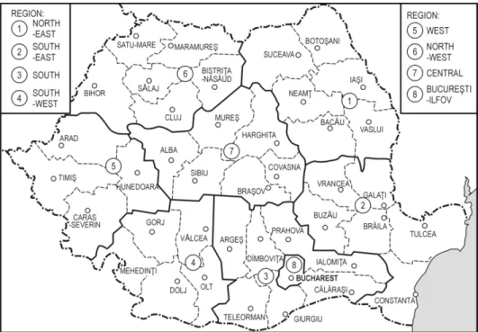
regions to be developed. Under such conditions, Romanian regionalisation process started and eight NUTS II regions were determined: seven of them con- taining more counties and one covering the capital Bucharest and its surrounding agglomeration, the so-called Ilfov County. These development regions were not administrative regions and did not acquire legal status. Figure 1 shows the bor- ders of regions and the numbers refer to the following region names:
1. North-East Region (Suceava, Botoşani, Iaşi, Neamţ, Bacãu, Vaslui coun- ties);
2. South-East Region (Vrancea, Galaţi, Buzãu, Brãila, Konstanca counties);
3. South Region (Ialomiţa, Cãlãraşi, Prahova, Dímboviţa, Giurgiu, Teleorman, Argeşi counties);
4. South-West Region (Gorj, Vãlcea, Olt, Mehedinţi, Dolj counties);
5. West Region, (Huniad, Arad, Timiş, Caran-Sebeş counties);
6. North-West Region (Bihor, Satu-Mare, Sãlaj, Cluj, Maramureş, Bistriţa- -Nãsãud counties);
7. Central Region (Alba, Mureş, Sibiu, Braşov, Harghita, Covasna counties);
8. Bucharest-Ilfov Region (the capital city and its agglomeration – Ilfov County).
Fig. 1. The NUTS II regions in Ro man ia since 1998 Source: B. Bodó (2003, p. 57)
This raises a question of whether these regions respect the peculiarities of Romania. Is this regionalisation process a real change in the regional approach and an authentic change of paradigm? Politicians, scientists, researchers and even citizens have focussed on this process since the NUTS II regions were formed in Romania. The present regional division of the country configured in 1998 has been criticised several times in different forums, and the topic of regionalisation frequently appears in various discourses, even in political ones.
Romania faces an administrative and territorial reorganisation process which would lead to the creation of a more decentralised model. The year 2013 was said to be the year of transformation: several debates and speeches dealt with the regionalisation issue, but only the very first steps were made until now.
The Governing Programme 2013–2016 devoted a chapter to this transforma- tion. This chapter, entitled ‘Development and administration’, presents important steps (Programul de guvernare 2013–2016, 2012). Another significant document is the so called ‘Memorandum – Adoption of the necessary steps to start the process of regionalisation-decentralisation in Romania’, which suggests the nec- essary organisational measures, such as the establishment of a body of strategic role in this issue. The Consultative Counsel of Regionalisation (CONREG) was established in 2013, with ten renowned academics selected as members. The main objectives of this body is to propose an optimal number of regions, to give suggestions regarding the system of the ‘local/regional autonomy, the regional competencies, the status of the local/regional elected officials, the electoral system of the local/regional elected officials, the regime of incompatibilities, prefects' role in the new architecture of public administration, mode of finan- cing, patrimony-related issues and proposals related to the establishment of the future regional seats’ (Memorandum 2012, p. 4). This academic working group holds its meetings in weekly working sessions. Several working papers have already been written by the members of this group, with experts setting up the Polish regionalisation process as a model for the new Romanian process.
Interestingly, the second report deals with the social development of existing regions, with cultural areas, and the role of historical regions of Romania in the regionalisation process (Disparităţi şi fluxuri… 2013).
The regionalisation process is also one of the main topics of disputes and discussions between the Romanians and Hungarians in Romania. Owing to the Hungarians' opinion, the existing regional division of the country has violated the European Union standards, the historical regions, the economic, cultural and environmental differences.
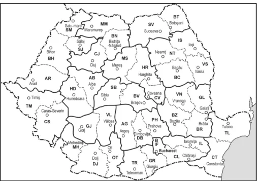
Fig. 2. The model by István Csutak for the Ro manian regional d ivision (2007) Source: I. Csutak (2007, p. 44)
For example the number of inhabitants of two Romanian regions exceeds 3 million people. The main political party of the Hungarians in Romania (RMDSZ) conceived a regionalisation model containing 16 regions in 2007. The author of this new model, István Csutak, declared that this proposed regional division would serve the regional development better than the existing one. In this new model, based on the development data of the counties and different calculations, the so-called Ţinutul Secuiesc (Székelyföld, Szeklerland) historical region would be a separate development region. For the Hungarians it is a very important issue, because this area is inhabited mainly by the Hungarian minority.
(Also see Csutak 2011 in this issue). Figure 2 shows this proposed regional division.
3. TRANSYLVANIA AND ŢINUTUL SECUIESC (SZÉKELYFÖLD, SZEKLER LAND)
AS HISTORICAL REGIONS
Why are Ţinutul Secuiesc (Székelyföld, Szeklerland) and Transylvania so important for the Hungarian minority in Romania? Historically, Transylvania used to have a separate character, but it could also be interpreted as an organic
part of Hungarian history. The quasi-independent Transylvanian Principality was born in 1541, when the Ottoman Empire occupied Buda. Its independence lasted up to 150 years, but this separation was in danger during this period: the world- -power countries wanted to limit (or abolish altogether) the independence of Transylvania.
The 1st and 2nd Diploma Leopoldium finally attached Transylvania to the Habsburg Empire, terminating the separation of the region. During the Rákóczi war of independence, Ferenc Rákóczi was elected suzerain by the Transylvanian Diet. With this act, the Diet wanted Transylvania to become independent again (before it, Rákóczi got the appointment as suzerain of Hungary from the Diet of Szécsény). Rákóczi needed this double appointment in order to enter into an alli- ance with Louis XIV. After the failure of the war for independence, Transylva- nia was returned to the Habsburg Empire, this time during the reign of Josef II.
The Kaiser received regency with the seat in Nagyszeben (Hermannstadt). With this, the Habsburg Empire wanted to break Transylvania away from Hungary.
The so called ‘Twelve Points’ formulated on 15 March 1848 declared the union with Transylvania, namely the fact that Transylvania was now a part of Hungary.
After 1919, based on these historical facts, the Transylvanian intellectuals emphasised the idea, that the so-called transylvanism should have been redefi- ned. As a consequence, the ideological stream of transylvanism was born, which determined the Transylvanian Hungarians' cultural-literary and ideological- -political movements for a long time. In Transylvania , the bottom-up regionalist processes are based on several pillars. They build upon the historic, ethnic and cultural uniqueness and the economic leader role of the region (see Miklósné Zakar 2007). The historical past of Transylvania has actually been supporting the argument according to which the region should be treated as a special entity.
The ethnic map of Transylvania is also a good basis for regionalism. However, this peculiarity has undergone important changes during and after the Second World War. The proportion of Romanian-Hungarian-German-Jewish ethnic groups varied because of the deportation of Jews during the war, then owing to the modifications made in the Ceauşescu era, which transformed the ethnic map of the country and, especially, the ethnic balance in Transylvania. The main part of the German group moved to West Germany with the ‘help’ of Romanian government, which sold them to West Germany. The relocation of Romanians en masse from other parts of the country to the industrial areas of Transylvania resulted in both the migration of labour and the destruction of ethnic proportions in the region.
Nowadays, there are no areas with high concentrations of ethnic groups in any part of Transylvania except for a special area called Székelyföld in
Hungarian, where Hungarians are still dominant. This fact shows the existence of an ethnic-cultural border between Transylvania and the rest of the country.
Anyway, the multicultural diversity of Transylvania is unique and specific in East-Central Europe. The Transylvanian regionalism can build both upon this peculiarity and upon the economic development of the region, because the GDP per capita is higher than in other areas of the country, except for the capital and its agglomeration.
4. THE PRELIMINARY R ESULTS OF OUR EMPIRICAL RESEARCH
This paper also aims to present the preliminary results of the research OTKA K 104801 entitled ‘The analysis of politico-geographic space structures in the Carpathian Basin – system changes, possible co-operations, incongruities at the turn of the 20th and 21st centuries’. The researchers want to map the possibilities of different co-operations between the countries situated in the analysed area, the transformation of both regional approaches and different notions of space. The research includes a mental map survey which has been conducted among students in several neighbour countries of Hungary, as following the role of education in the shaping of mental space may prove interesting. The researchers are also interested in the political space and structure of the countries, in the changes of these structures in the examined period (public administration, town networks, electoral districts, directions of connections, development peculia- rities).
This paper wishes to present some preliminary results of this research in the context of Romania. We have also conducted surveys in Romania: 198 university students were asked to fill in our questionnaires in Bucharest, Cluj- Napoca, Timişoara and Sibiu. The regional division of the country is an important debate topic between the organisations of the Hungarian ethnic group in Romania and the state institutions, and there is tension between these concepts. Therefore, we also asked students belonging of Hungarian ethnic group and studying in Hungarian to fill in separate questionnaires. 36 question- naires were filled in by the ‘Hungarian control group’ in Romania.
Naturally, our survey was not representative. The respondents (youth from universities) obviously belonged to a more qualified and open group in the society than the average. Even so, their opinion is an adequate mirror to demonstrate the spatial approach of the society. This is due to the fact that public education forms our spatial approach through the books, textbooks and maps
used during education. The socialisation within the family, in which the peculia- rities, ethnic features of our home place and the historic approach are taught are also very important. The state transmits its own spatial approach to its citizens through public education, insuring the unity of the state and the state nation conscience. Therefore, it is interesting to analyse and compare the geography textbooks of different countries with the textbooks and maps of different regimes in the same country.
The approach transmitted by the materials used in public education is usually modified or intensified by other common information and maps (even the maps seen in the weather reports on television, their division and peculiarities), the different state and non-state propaganda materials, conceptually coloured and ornamented maps depicting imaginary or concrete geographic-historic situations.
They can all be considered ‘top-down’ effects on our personal spatial approach.
The personal impacts are also significant. These are the social impacts from the family, the personal interests, the deeper knowledge of the home place and other areas (such as regularly used routes, the travelling destinations).
As we noted, uniform basis is given by education. However, other factors can differ depending on ethnicity. People belonging to a given ethnic group have other relationships. They use different geographical notions in the family and in the ethnic group (especially in the case of Hungarian ethnic group in Romania, who live and act mainly in a certain region of Transylvania).
Territorial identification and spatial approach are very important in the formation of regions. Therefore, our research can help explain the different regionalisation concepts of Romanian and Hungarian ethnic groups. There are obviously other factors which cause the differences.
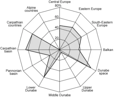
One of the first questions in the survey concerns the geographic space categories Romania belongs to? We enumerated politico-geographic categories such as Central Europe, South-Eastern Europe etc., including physical geo- graphic factors which also had some political symbolic value in some countries of the analysed area. The Romanian respondents described Romania as a ‘Carpathian’ and ‘Danube’ country; the politico-geographic categories Central, Eastern and South-Eastern Europe were less accentuated as the characteristic of the country. None of these categories stood out from the rest, so there was no explicit identification in this issue (see figure 3).
There are thus close ties to two physical geographic elements: Carpathian Mountains and the Danube River. This fact is important in the case of Romania, as the Carpathian Mountains form the main inner dividing line in the country, while the Danube constitutes a long segment of the state border and the Delta area with the coast is one of the important gateways into the country. In addition,
the longest section of the above mentioned mountains and river are situated in Romania. It was surprising for Hungarian researchers that the respondents chose the spatial notion of ‘Carpathian Basin’ in similarly high proportion, as the notion is used in Hungary and in Hungarian geography for the basin-like area surrounded by the Carpathian Mountains, the Alps and the Dinarides. At the same time, this notion carries political meaning, it coincides territorially to a considerable extent with the area of the so called ‘Great-Hungary’ before the First World War. Therefore, the name is not used and not known in the neighbour countries, and if it is used, it represents the spatial concept associated with historical revisionism. As we can observe from the other parts of our questionnaire, Romanian respondents used the notion of Carpathian Basin instead of ‘Transylvanian Basin’, which is surrounded by the Eastern and Southern Carpathians, and Munţii Apuseni. The Transylvanian Basin is an im- portant developing area of Romania.
Fig. 3. Distribution of answers to the question ‘Which geographic space categories does Romania belong to?’ (%)
Source: Questionnaires 2013
In order to gauge the respondents’ opinion about the inner territorial units of the country, we asked them to draw regions on the map of Romania which con- stitute the country (historic, ethnic, geographic regions, not the NUTS II ones).
This quality at which the task was completed differed, as the drawing ability and geographical knowledge among the respondents varied. The aggregation and
exact evaluation of answers have been a difficult task, but we can find some typical, standard answers.
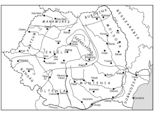
The first important statement is that almost every appraisable answer contains historical units or their disaggregation: Oltenia, Moldova, Transylvania and Dobrogea. Even the roughest and worst variants of the graphic answers contain these regions and their boundaries are quite correct. Figure 4 below shows this basic variant.
Fig. 4. Map with four h istorical regions Source: Questionnaires 2013
Differences can be observed within these units in the drawings. In the most common variant, students divided the country into 8–9 units, usually following the historical regions. This division seemed to be typical in the case of both Romanian and Hungarian respondents, differences could be observed only in the use of geographical names.
These units are: 1. Oltenia, 2. Muntenia (Greater Wallachia), 3. Dobrogea, 4. Transylvania or Ardeal in the Romanian answers, Erdély in the Hungarian an- swers (Transylvania), 5. Moldova, 6. Banat, 7. Crişana (in the Hungarian an- swers: Partium), 8. Maramureş, and in some answers 9. Bucovina (see figure 5).
Fig. 5. Map with nine reg ions Source: Questionnaires 2013
Fig. 6. Exa mple of a Ro manian answer using smaller regions Source: Questionnaires 2013
Fig. 7. Hungarian answer e mphasising Ţinutul Secuiesc (Széke lyföld, Sze kle rland) within Transylvania
Source: Questionnaires 2013
Fig. 8. Hungarian answer using ethnographic units Source: Questionnaires 2013
The Carpathians appeared as a separate region only in three answers when the respondents marked the borders of the area of the mountains. This shows that both the Romanian and the Hungarian respondents divide the country mainly into historical units.
The ethnical differences appeared in the further division of historical units.
Romanian answers only rarely contained smaller territorial units than the above mentioned ones. There were only five Romanian respondents who divided Transylvania into the northern and southern parts, and only three respondents who divided other regions such as Valea Siretului, Făgăraş into smaller units.
Half of the Hungarian control group divided Transylvania into several smaller units (see figure 7).
Ţinutul Secuiesc (Székelyföld, Szeklerland) appeared in almost all Hungarian answers, but several other ethnographic and ethnic areas or regions were mentioned. Transylvania did not appear as a unit in just six cases (see figure 8).
5. CONCLUSIONS
Our main conclusion could be that the spatial approach acquired in the course of public education is present uniformly in the minds of respondents belonging to both Romanian and Hungarian ethnic groups. The socialisation variations based on ethnic differences have added some diversity in the use of geographic names and have resulted in the fact that the Hungarian respondents used smaller territorial units in their answers. This tendency is observable in the context of Ţinutul Secuiesc (Székelyföld, Szeklerland) and other Transylvanian ethno- graphic and ethnic territorial units (inhabited not only by the Hungarian minority), which shows their close ties with these regions and strong identity.
This identity sometimes seems to be stronger than the Transylvanian regional identity. After learning these answers, it becomes obvious that the new regiona- lisation process should also take into account the importance of historical regions in Romania.
This paper was written with the help and support of the following project: OTKA K 104801 entit led: ‘The analysis of politico-geographic space structures in the Carpathian Basin – system changes, possible co-operations, incongruities at the turn of the 20th and 21st centuries’.
REFERENCES
BODÓ, B., 2003, De zvoltarea regională în Ro mânia, [in :] Politica regională şi dezvoltarea teritorială (Capitolu l III). Manual SEDAP, Te mesvár, pp. 52– 79.
CSUTAK, I., 2007, Új? Rég i? Jó? – Új régió kat Ro mániának (RMDSZ-kiadványok):
http://www.rmdsz.ro/ kiadvanyok/_fejlesztesi_regio k.pdf (03.07.2010).
CSUTAK, I., 2011, Szüntelenül erősíteni a látszatot. Ro mánia fejlesztéspolitikai kudarcának oka iró l, MTA, VKI Műhelytanulmányok, No. 90.
Disparităţi şi flu xuri în fundamentarea social-economică a regionalizării ad ministrative a Ro mânie i, 2013, CONREG, Bucureşti:
http://regionaliza re.mdrap.ro/wp-content/uploads/2013/04/Raport-de-progres- 2_CONREG.pdf (24.07.2014).
Memorandu m – Adoption of the necessary steps to start the process of regionalisation- decentralisation in Ro man ia, 2012: http://insideurope.eu/node/327 (15.07.2014).
MIKLÓSNÉ ZAKA R, A., 2007, A transzilvanizmus kultúrtörténeti jelentősége, Kultúra és Közösség, 2 (3), pp. 120–123.
Progra mul de Guvernare 2013–2016, 2012: http://gov.ro/fisiere/pagini_fisie re/13-08-02- 10-48-52progra m-de-guvernare-2013-20161.pdf (03.07.2014.)