ASYMMETRIES IN THE FORMATION OF THE TRANSNATIONAL BORDERLAND IN THE SLOVAK-HUNGARIAN BORDER REGION
HARDI, Tamás Introduction
A significant social experience of the present day is the increasing permeability of the internal borders of the European Union, a result of the elimination of the physical barriers to border crossing, allowing the freedom of travel. It is difficult to overstate this change for those who some years or decades ago were not permitted to cross the border, and also for those who had to wait for hours, often in almost intolerable conditions, in front of border crossing stations and were only able to continue their travels after humiliating bureaucratic procedures. In most cases, the partial and then the complete opening of the borders was welcomed with enthusiasm, and the ever greater permeability of the borders serves the integration of the economic and political macro-systems of nation states, leading to the emergence of an enlarging supranational economic and political space in which the free flow of persons, labour, goods and capital is secured. In this system border regions occupy a unique place and, it can be argued, play a unique role. Will this cross-border flow pass them by, will they remain struggling peripheries of the nation states, or can they use the opportunities offered by this new situation? Is space opening up for them too? And what role do they play role in the process of opening up?
Borders and border areas are all unique, individual phenomena. The birth, change and character of the spatial borders depend to a large extent on the spatial unit (in this case the state) that they surround, but this is a symbiotic relationship: states, border regions, and the characteristics of the state border all influence each other (Hardi, 2001). This complexity must be taken into account in our research on border regions. It is not enough to analyze the political, social, economic and cultural features of these regions by the comparison of case studies; we have to strive for a deeper understanding by combining historical contextualization with a general theoretical framework.
In the following we will try to illustrate such an approach by drawing on the study of the Slovak- Hungarian border. The concrete research question is in what circumstances and to what extent the population of the Slovak–Hungarian border regions can make use of the possibilities offered by the accessibility of the “other side” and if there is a chance for the birth of single cross-border regions and a transnational society.
The paper is built on the findings of three questionnaire surveys :
In 2008 a survey was conducted along the total length of the Slovak-Hungarian border region, with layered sampling, questioning 1,000 people on each side of the border. The research area was a border area defined by using a functional approach (Hardi and Tóth, 2008).1
In 2010 we examined the situation of those living in suburban Bratislava, comparing the situation of the population living on the Slovak side and the population that moved to the Hungarian side. Using the snowball method we examined the group of those moving out after 2004; 360 inhabitants were questioned on the Slovak side and 240 on the Hungarian side (Hardi, et al., 2010).2
1 Scient ific Basic Research for the Socio-economic Analysis of the Slovakian–Hungarian Border Region. (ID:
HUSKUA/05/02/117 ) The project was implemented in the Hungary–Slovakia–Ukraine Neighbourhood Programme.
2 AGGLONET Hungarian-Slovak suburbia surrounding Brat islava 2009–2010 supported by Hungary–Slovakia
Cross-border Co-operation Programme 2007-2013 HUSK/0801/1.5.1/0007
In 2014 we conducted a mental map survey among students; in Slovakia 194 students of Slovak nationality and 69 students of Hungarian nationality were interrogated in five cities distributed evenly across the country, while in Hungary, 244 students (all of Hungarian nationality) were asked in seven cities (Hardi, 2015).3
1. The Applicability of Martinez’s Borderland Theory to the Case of Hungary and Its Neighbours
A dynamic definition of borderlands was made by Martinez, who defines four types of border areas on the basis of the number and depth of cross-border interactions. In “alienated borderlands” tension prevails; the border is functionally closed, and cross-border interaction is totally or nearly totally absent while residents of each country act as strangers to each other. In “co-existent borderlands”
stability is an on and off proposition; the border remains slightly open, allowing for the development of limited binational interaction; residents of each country deal with each other as casual acquaintances, but borderlanders develop closer relationships. In “interdependent borderlands”
stability prevails most of the time; economic and social complementarity prompt increased cross- border interaction, leading to expansion of borderlands ; borderlanders carry on friendly and cooperative relationships. And in “integrated borderlands” stability is strong and permanent;
economies of both countries are functionally merged and there is unrestricted movement of people and goods across the boundary; borderlanders perceive themselves as members of one social system (Martinez, 1994, p.3). This typology implies the notion of change in the sense of a gradual increase of transborder interaction and transnationalism.
We believe that the borderland types defined by Martinez are perfectly applicable to the border regions of the former socialist countries and help us to understand the changes that they underwent over the last quarter of a century. In the period before the regime change, the modes of interaction that characterized the respective state borders were not the same as afterwards. Although totally closed borders (alienated border regions4) were not existent either, it is undeniable that daily or regular border crossing was only possible for a narrow layer of the population. It is important however to consider individual cases and particularities. While on the Soviet–Hungarian and the Austrian–Hungarian border permeability was severely restricted, the Slovak–Hungarian relationship was more liberal from the seventies. In fact, all borders of Hungary can be described as having been of the “co-existent” type in the seventies and eighties, but at certain sections the centralised state approved of specific alleviations, allowing regular border crossing of the population of the border region, including commutes to work in some cases. At the time of the regime change the border regions of Hungary gradually turned into interdependent borderlands, one of which is the border region treated in our paper. After the accession of Slovakia and Hungary to the European Union we can see some sections of the borders develop into integrated borderlands, but so far this has happened in just a few places and only to a limited extent.
Another important element in Martinez’s theory is the introduction of the notion of borderland society.
In this society we can distinguish so-called national borderlanders and transnational borderlanders, whose proportion correlates to the integration level of the border region. While in the case of alienated
3 The research was supported by the OTKA (Hungarian Scientific Research Fund) “Analysis of the political
geographical spatial structures in the Carpathian Basin (regime changes, cooperation possibilities and absurdities on the turn of the 20th and 21st centuries)”, Research leader: Hardi, Tamás. ID: K 104801.
4 We can use this category to describe the situation of the early fifties only. After this period the permeability of
the border became easier and easier.
borderlands there is practically no person who belongs to the latter group, in integrated borderlands their proportion is high.
But what defines these two types? In the words of Martinez:
National borderlanders are people who, while subject to foreign economic and cultural influences, have low-level or superficial contact with the opposite side of the border owing to their indifference to their next-door neighbours or their unwillingness or inability to function in any substantive way in another society. Transnational borderlanders, by contrast, are individuals who maintain significant ties with the neighbouring nation; they seek to overcome obstacles that impede such contact and they take advantage of every opportunity to visit, shop, work, study, or live intermittently on the “other side”. (1994, p.6)
Joining the Schengen Agreement and as a result opening its borders allowed the development of increasingly denser and more in-depth interactions in the border regions of Hungary. The (according to our survey) everyday experiences of the author show, however, that characteristic transnational borderlanders have appeared in very narrow places and in very limited numbers, and their distribution is asymmetric (this transformation is more typical of the inhabitants of the Slovak side than those of the Hungarian side of the common border). An important feature of the last 20 years in Eastern Europe is the fact that, parallel to the weakening of the separating role of borders , nationalism has become palpably stronger, and the opening borders also reinforced the sense of danger represented by the other side. This evidently slows down the integration process as it blocks, among other things, the development of cross-border infrastructure (construction of new border crossing stations, roads, bridges, etc.).
The Slovak–Hungarian border region is interesting for our topic because among all borders of Hungary this one contains areas that come closest to the borderland category named integrated by Martinez, meaning that they have the highest number of people who “use” the other side of the border on a daily basis, and that the proportion of transnational borderlanders is the largest here (according to our survey). We have to admit though, that the east–west differences are significant: advanced integration is true for the western section of the Slovak–Hungarian border, mainly, and even there it is restricted to the hinterlands of major cities; also, interactions in significant numbers and depth are primarily typical for the Slovak side.
We think it is important to remark that the theory of Martinez reflects a concept of nation, which builds on the category of political nation. In the region under study here, however, concepts of nation and nationalism are stronger, which integrate as parts of the nation the groups living outside the state territory, but belonging to the cultural/linguistic nation as well (e.g. the Hungarian ethnic minority that lives in Slovakia). These minorities see themselves as part of a culturally defined mother nation and typically identify less with their political nation. As the paper will reveal, the group of transnational borderlanders mainly emerges out of these minorities, so the attribute “transnational” has a special interpretation in this region. The members of this group are not made “transnational” by commuting to the other side of the border and adopting the language and culture of the other nation, but by the fact that they feel that they belong there (too), while the language and culture of the nation state they live in is something that they have adopted (whether at school, in families of mixed ethnicity or in the residential environment).
In addition, our research demonstrates a higher cross-border activity by the Slovak ethnic population of the Slovak side than by the Hungarians living in Hungary. We can thus distinguish a specific group of transnationals who – especially in the region of Bratislava – establish a cross-border living space based
on urban hinterland and economic rationality, and whose transborder way of life is not motivated by ethnic or language reasons but the practicality of everyday life.
To summarize, we can describe the Slovak-Hungarian border as giving rise to a multiplicity of borderlands. On the one hand there is a clear west–east difference in the degree of transborder contact that is linked above all to geographical and economic development reasons. On the other hand, we find asymmetry between the two sides of the border, namely a higher transborder activity on the Slovak side.
2. An Introduction to the Border and the Border Region
2.1. Historical and geographical features of the border
The Slovak–Hungarian border region is situated in an area that belonged to single-state formations until the end of World War I: the Kingdom of Hungary and the Austro–Hungarian Monarchy. After the foundation of the Hungarian state (in 1000) the territory of the present Slovakia was part of the Kingdom of Hungary, which lasted, with varying levels of sovereignty, until the end of World War I, in relatively constant geographical frameworks except for the time of the Ottoman occupation. The Slovak and the Hungarian ethnic group, despite the basically different languages, showed similar cultural features in many respects as a result of their long co-existence, and mutual assimilation was strong. The main grievance of the Slovak ethnic group is that their nineteenth-century nation building movements were confronted with strong language nationalism by the Hungarian state, and the language act passed at the end of the century tried to assimilate the Slovaks (and all other ethnicities).
Of the population of the Kingdom of Hungary at the end of the nineteenth century, approximately half were Hungarians and the other half belonged to different ethnic groups. The ethnic relations in the whole of the Austro-Hungarian monarchy were just as (or even more) complex. The centralizing language nationalism, the secession efforts of the strengthening ethnic minorities and the geopolitical efforts of the super powers together led to the disintegration of the Kingdom of Hungary and the monarchy. In the newly created Czechoslovakia language nationalism was just as prevalent as in the former state formations: after World War II masses of Hungarians were expatriated for the sake of ethnic homogenisation, and in independent Slovakia, formed after 1993, the ethnic and language intolerance against the Hungarians has often been visible as well.
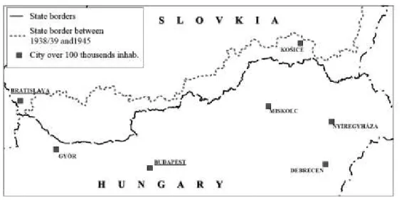
The state border between Czechoslovakia and Hungary was created by the peace treaty concluding World War I. This border did not follow the ethnic border, as significant areas inhabited by a Hungarian majority were annexed to Czechoslovakia. In the peace treaty of 1920 the border was designated mainly on the basis of economic, military-strategic and transport geographical considerations (Hevesi and Kocsis, 2003), and so personal relations, settlement networks and ethnic considerations, all important for the organisation of the everyday life, were not considered during the decision-making. The border was pushed northwards in connection with the Munich Agreement in 1938, then in 1939 Hungary occupied Zakarpatska region (Carpatho-Ukraine) that used to belong to Czechoslovakia/Slovakia5 at that time and belongs to the Ukraine now, which also modified the
5 The “First Vienna Award” (the Vienna Arbitration and Award was a consequence of the Munich Agreement in 1938) separated the ethnic Hungarian-populated territories in southern Slovakia and southern Carpatho-Ukraine from Czechoslovakia and awarded them to Hungary. Slovakia seceded from Czecho -Slovakia in March 1939, and in mid-March 1939, Hungary occupied the rest of Carpatho-Ukraine from the newly founded Slovakia.
contemporary Slovak–Hungarian state border (Figure 1) and resulted in the return to Hungary of south Slovak areas inhabited by Hungarian majorities. This situation existed until the end of World War II.
Figure 1. The Slovak–Hungarian borderland and the state border modification in 1938–1939
Source: the author
The ceasefire agreement (1945) restored the situation that existed before 1938, and the peace treaty annexed another small area (part of the Bratislava region) to Czechoslovakia. After the disintegration of Czechoslovakia, Slovakia inherited the state borders.
In the Slovak historical consciousness the interpretation of history tries to relativize the Hungarian supremacy, and uses the expression “Uhorsko” to denote the historical multi-ethnic Hungarian state, while the expression “Madarsko” is applied to specify the area inhabited by ethnic Hungarians and also the modern Hungary. According to this view, in the common historical state the ethnic Hungarians oppressed other nationalities, forcing these peoples to secede from the state and re- establish their sovereign national existence that had been interrupted in the ninth century. On the other hand, Hungarian interpretation links the historical Hungary to the existence of the Hungarian state, and considers the territory of Slovakia (together with the territories annexed from Hungary after World War I) as lost parts of the country.
The Slovak–Hungarian state border is 679 kilometres long, the longest border section in both Slovakia and Hungary. On the western part of the border, the border is made by the Danube River for approximately 143 kilometres. Crossing this section is assisted by three bridges and a tourism-oriented ferry. In this area we find significant cities and city pairs in the proximity of the border: Bratislava, Győr, Komárom–Komarno, Esztergom–Sturovo. The middle and eastern sections of the border are a mountainous area, partly with riparian border (the Ipoly/Ipel River comprises the border at a length of 143 kilometres) and partly with land border. This area has smaller, more peripheral towns. In the easternmost section we find large cities again, although not in the direct proximity of the border, and a landscape of gentle hills and plains. On the basis of geographical and urban network features, the border region can be divided into five sections.
1) The agglomeration of Bratislava. This involves the traditional suburban zone of the Slovakian side up to Somorja, the main commuting region of the capital city of Slovakia. The agglomeration of Bratislava has now reached across the state border and involves the area of Mosonmagyaróvár close to the border and also some Austrian territories. The agglomeration is contiguous to the agglomeration of Vienna, and the impact of the two capital cities is jointly shaping the area.
2) The zone of the Danube cities. This entails Győr and the so-called Danube city pairs, the most prominent of which are Komarno/Komárom and Sturovo/Esztergom. It is especially the geographical location of the two Komárom settlements and Győr that led to the birth of considerable cross-border catchment areas. The special importance of these city pairs is given by the fact that they can now be taken as single urban agglomerations. Together they have a population in excess of 50,000, so their common services and economic attraction are equal to that of a medium-sized Hungarian city, not to mention the high density of population in the economic agglomeration along the right bank of the Danube River (from Almásfüzitő to Dorog).
3) The zone of the mountainous towns. This zone reaches from the mouth of the Ipoly River to the edge of the hinterlands of Košice and Miskolc. Its western part is adjacent to the agglomeration of Budapest, including Vác. On the other hand, the low level of urbanisation along the Ipoly River is also due to the drainage effect of Budapest. The area between the Börzsöny Mountains and the Ipoly River gravitates to the city of Esztergom, which is made possible by the Schengen borders and the exiting bridges across the Ipoly and Danube. At the northern foot of the North Hungarian Mountain Range there are the aforementioned towns with 20,000–50,000 inhabitants (Salgótarján, Ózd, Kazincbarcika, Lučenec, Rimavská Sobota), but they are somewhat further from the border (10 to 20 kilometres).
Directly on the border we only find smaller centres (Šahy, Balassagyarmat).
4) The hinterlands of Košice and Miskolc. The border regions of the two cities are characterized by a deficient urban system, especially on the Hungarian side (being one of the least urbanized areas in Hungary). North of Edelény in the Zemplén Mountains we do not find any major central settlement.
The areas directly on the border may gravitate to Košice more than to Miskolc, even on the Hungarian side.
5) The area of the triple border in the east. This region has a weak urban network in both countries.
Smaller centres can only be found on the Hungarian side, such as Sátoraljaújhely and Sárospatak, and especially the latter has strong cross-border attraction. On the Slovakian side, Trebišov can be found a bit farther from the border, and its services are too weak to have attraction on the Hungarian side of the border as well.
2.2 The question of ethnicity and languages
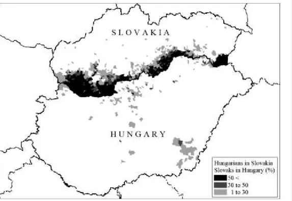
In cross-border interactions, an important role is played by the ethnic and language relations of the border regions. In Slovakia the largest ethnic minority is Hungarian. According to 2011 census data, from the total population of Slovakia (5.4 million people) 8.5% declared themselves as ethnic Hungarians, and 9.4% stated that their mother tongue was Hungarian. The approximately 450,000 ethnic Hungarian citizens are concentrated in the southern areas of Slovakia bordering Hungary. An important feature of the border region is the strong presence of Hungarian ethnic population in the immediate border districts of the Slovak side, reaching in some cases 80% of the local population. In contrast, on the Hungarian side the proportion of population with Slovak ethnicity and mother tongue is negligible. Hungary has a Slovak ethnic minority, but it made up approximately 0.3% of the total population of 9.9 million people in 2011, and Slovaks comprise the majority of just a few settlements.
What is more, those settlements that have a significant number and proportion of Slovak population
are found in the southeastern part of the country, in the vicinity of the Hungarian–Romanian border, and very few are located in the vicinity of the Slovak-Hungarian border (see Figure 2).
Figure 2: The share of ethnic Hungarians in Slovakia and ethnic Slovaks in Hungary by settlements, 2011
Source: the author; data from 2011 censuses
This disparity also impacts language skills. Slovak and Hungarian languages are fundamentally different. While Slovak language belongs to the family of Western Slavic languages, Hungarian is a Finno-Ugric language and its closest relatives are Estonian and Finnish. As we have shown in the demonstration of the ethnic relations, the majority of the inhabitants living on the Slovak side of the border region speak Hungarian; in fact, they consider Hungarian as their mother tongue, and even a large portion of the ethnic Slovak population speaks or understands Hungarian, due to the significant proportion of Hungarians living in their environment. On the other hand, on the Hungarian side only a very small proportion of the population speaks or understands Slovak.
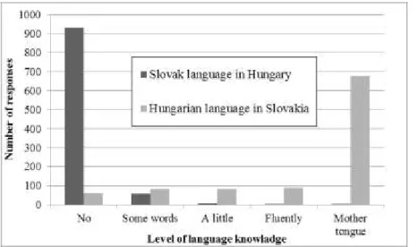
We conducted a survey among the inhabitants of the border region concerning language skills in 2008 with 1,000 inhabitants on the Slovak and another 1,000 on the Hungarian side (Figure 3). In Slovakia, 68% of the respondents declared Hungarian to be their mother tongue, and the majority of the other respondents mentioned language skill at some level, while the proportion of those who said they did not speak Hungarian was only 6%. On the other hand, only three people of those asked on the Hungarian side declared Slovak their mother tongue, and 93% indicated that they did not know the language of the northern neighbour country.
Figure 3: Language knowledge in the Slovak–Hungarian borderland
Source: the author; data source: 2008 questionnaires
Another important ethnic feature of the border region is the high proportion of inhabitants belonging to the Roma ethnicity. In the censuses of 2011, 2% of the population in Slovakia and 3% in Hungary declared that they were of Roma ethnicity. However, the real figures of the Roma population are much higher than registered in censuses, as many do not want to admit their Roma identity in the questioning session. In the eastern part of the border region, the share of Roma ethnic minority is particularly high (Figure 4), especially in the isolated, peripheral areas along the border where their high proportion is accompanied by extreme poverty and segregation. In this respect the state border is not a separating line, as both states struggle with similar problems. Parallel to the dynamic development of the western part of the border region there are considerable social problems and crisis situations along the east sections .
Figure 4. The share of Roma population in Slovakia and Hungary, by settlements, in 2011
Source: censuses, 2011
2.3 Economic development and disparities
The territorial disparities of regional gross domestic product (GDP) clearly indicate that the most developed areas of both states can be found along the common border (Figures 5 and 6). The strong concentration of the economy in the western border section is undeniable. The capital cities of both countries have a significant and still growing share of the total production in their countries. Bratislava in 2001 accounted for 24.6% of Slovakia’s total GDP, and this share grew to 27.6% in 2011. The economic weight of Budapest is even larger, as it represented 34.7% of GDP in 2001, increasing to 38.3% in 2011. Among the counties along the border, the growth of the western ones is dynamic. Both in Hungary and Slovakia an increase greater than the national average was typical in these areas from 2001 to 2011. In Slovakia it is Trnava that boasts of the highest production per capita after Bratislava, and during the whole of the decade these districts show the fastest growth in Slovakia. Their share from the production of Slovakia also increased over the course of the decade, while the proportion of middle and eastern Slovakia decreased. In the east it is only the Košice district that shows a considerable growth, approaching the national average. All this demonstrates that the economic power of Slovakia is concentrated in the western and northern areas of the country, and in the east Košice stands out as an island. On the Hungarian side of the border it is the western areas, too, that show the fastest growth, and the largest number of goods produced, only surpassed by the capital city. The weight of Budapest (and Pest county) within Hungary exceeds that of Bratislava and Trnava districts together in Slovakia, both in value produced and the number of population. Despite the basically high level of development of the western counties in Hungary, the regional disparities in the whole of Hungary and also across the border counties are bigger than in Slovakia. In Hungary the western
Megjegyzés [PP1]: Caption: final
“n” in population is cut off.
counties (Győr-Moson-Sopron and Komárom-Esztergom) grew far above the national average in the decade in question, and have become the most developed Hungarian counties after Budapest.
Symmetries and asymmetries are clearly visible: along the western section of the border the most advanced areas of the respective countries can be found on both sides. In Slovakia the three neighbouring western districts (Bratislava, Trnava and Nitra), and in Hungary, Budapest and three counties (Pest, Komárom-Esztergom and Győr-Moson-Sopron) produce half of the GDP of the respective countries. Especially in Slovakia this proportion seems to be growing. On the other hand, the development level of the eastern part is below average on both sides, and while Košice stands out as an island in Slovakia, Miskolc fails to have the same function in Hungary.
It is an interesting phenomenon, at the same time, that while in 2001 the Hungarian side had higher GDP values in the more advanced western areas, the districts of the Slovak side reached a higher level during the decade in question, due to their more intensive growth, and on the whole they are more developed now than the Hungarian side. This is especially visible in the changes of work-motivated migrations. In the middle of the 2000s, approximately 30,000 Slovak commuters travelled to work to the facilities along the border in Hungary (especially on the western, Danubian side). This figure has decreased to a fraction of that by now, and commuting only remains typical in those areas where it is difficult to find a job on the Slovak side due to the peripheral location (e.g. from Sturovo to Esztergom). In other towns and cities this phenomenon is less common now because wages today are lower in Hungary than in Slovakia, although the difference is very small. Furthermore, the introduction of the Euro in Slovakia and the weakening of the Hungarian forint made conversion less favourable for employees than it had been during the period of the existence of autonomous Slovak currency (Slovak crown). It is interesting to note that recently the Slovak automotive industry has recruited labour force from the Hungarian border region.
Figure 5: Regional GDP per capita in Slovakia and Hungary at current market prices by NUTS 3 regions, 2001
Source: the author; data source: EUROSTAT
Figure 6. Regional GDP per capita in Slovakia and Hungary at current market prices by NUTS 3 regions, 2011 and change 2011/2001 (%)
Source: the author; data source: EUROSTAT.
2.4. Mental borders among inhabitants of the borderland
From the perspective of cross-border interactions, the examination of mental borders existing in the minds of the population in the borderland is extremely important. In our paper at least three groups must be distinguished in this respect: Hungarians in Hungary, Slovaks, and Hungarians in Slovakia.
Mental borders are not only impacted by state borders, but are also influenced by historical, ethnic, language and national identity issues .
In the spring of 2014 we conducted a mental map survey in five cities of Slovakia, in which 194 Slovak and 69 Hungarian university students were asked to draw the regional breakdown of Slovakia, introduce the regions and specify where they would happily or less happily move. The mental maps differed significantly between ethnic groups. For the Slovak students, the northern and eastern parts of the country were more important, and they designated respective regions in geographically correct detail. Meanwhile, they often used the expression “Madarsko” for the southern areas of the country inhabited by Hungarians, and most respondents did not differentiate within this region and rejected this area as a potential destination for relocation. This southern strip of land is not a single area on either geographical or historical grounds, but it is separated from other parts of Slovakia on ethnic grounds. The Hungarian subsample, on the other hand, gave inverse answers. This difference can be traced back to the fact that the two ethnic groups have traditionally been segregated, with people of Slovak ethnicity inhabiting the regions of mountainous territories while Hungarians lived in the plain lands, and so the mental maps were formed and confirmed generation after generation.
Another ground for the separation of the southern land strip is the modification of the border in 1938.
This change was experienced by Hungary as a “regaining” of the territory, and as the “mutilation of the country” by Slovakia. As explained in the historical section, Hungary was given the southern land strip inhabited by a Hungarian majority, but after World War II the former borders were restored, returning the land inhabited by Hungarians to the newly formed Slovakia (Figure 1). This border that existed for a few years still has its mark on political and public attitudes. During the socialist regime it operated as an important “crypto-border” for development policy, in so far as several economic and infrastructure developments were located north of this borderline, and not south. It is also worth mentioning that during the designation of the administrative units in the 1990s, it was also an important aspect (and a topic of debate) that the districts (kraj, i.e. NUTS3) should preferably have a north to south extension, so these administrative units split the homogenous ethnic Hungarian zone. As a result of this, the ethnic characteristics and the gradual economic and infrastructure underdevelopment of the southern land strip are not visible in the territorial statistics, although the economic, modernizising and demographic centre of the country moved northwards in the last decades.
All in all, we can also say that the skills and experiences concerning the other side of the border are not the same among the groups in question. With a view to the fact that Slovakia is home to a large number of inhabitants of Hungarian ethnicity, the Slovaks, especially the ones living in the borderland, have daily contacts with the Hungarians living in Slovakia: they speak or understand Hungarian and may have family members of Hungarian ethnicity. Irrespective of how they judge the Hungarians, this leads to a higher level of information and relationships. Hungarians living in Hungary have relatively little direct experience with the Slovak population. They rarely visit Slovakia, and their direct contacts are usually limited to the Hungarians living there, and so the knowledge of the Slovak language is evidently less important. Similarly limited is the experience that Slovak citizens living farther from the Hungarian inhabited areas have, and their relationship networks are also narrower, while the Hungarians living in the border region in Slovakia have the largest relationhsip network.
3. Asymmetries in Cross-border Interactions 3.1 Asymmetries in travel habits
The travel habits of the inhabitants living in the border area shed light on the integration level of the border region. We looked at how often and with what purposes inhabitants visited the other side of the border, and our 2008 survey allows for a more detailed analysis of the travel habits of the borderland population. At that time, 97% of the interrogated ethnic Hungarians living Slovakia had been to the other side of the border, while the figure for the inhabitants of Slovak ethnicity was 94%. Only 79.9%
of Hungarian respondents living on the Hungarian side had been to Slovakia.
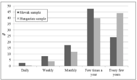
There are considerable differences in the frequency of travel as well. A significant proportion of the inhabitants on the Slovak side, approximately 28.3%, travel daily, weekly or monthly to Hungary, while only 16% of those living on the Hungarian side visit Slovakia regularly (Figure 7).
Figure 7: Frequency of visiting the other side
Source: the author; data source: 2008 questionnaires
Among the respondents coming from Slovakia, the frequency of daily visits to the other side was somewhat higher than the average in the western part of the area, amounting to almost 5%. Visits of daily and weekly frequency were usually linked to shopping and the use of services, while the main reason for irregular travels was tourism. It is clear that if more than a quarter of the population living in the borderland on the Slovak side visits Hungary daily or weekly, the number of interactions is high. The proportions have probably changed in the last years: while commuting with employment motivation is less typical now, using the other side of the border for business purposes has become more frequent, as has the moving of Slovak citizens to Hungary for residential purposes. In contrast, the number of border crossings from Slovakia to Hungary for shopping is now higher than in the opposite direction. Due to the introduction of the Euro in Slovakia and the worsening exchange rates of the Hungarian currency, it is economically beneficial only for the citizens on the Slovak side to use Hungarian shops and services, whereas crossing for shopping in the opposite direction has practically ceased. The asymmetry in this respect has presumably grown since 2008.
3.2 Asymmetries in personal relations
We also looked at the personal relations network of the respondents in 2008, which reflected visible differences between the two sides of the border as well. Under the category “personal relations” we included family and friends as well as workplace and business relationships. Among the respondents on the Slovak side, 53.1% had some personal contacts on the other side of the border, while the figure for those on the Hungarian side was only 25.7% (Figure 8). Ethnic differences could of course be seen on the Slovak side. While 62.3% of the respondents with Hungarian nationality maintained some personal relations on the other side, only 34.5% of the Slovaks did so.
Figure 8: Number and type of personal contacts on the other side of the border (Share of Yes answers,
%)
Source: questionnaire 2008; figure by the author, based on Csizmadia 2008.
If we look at the complexity of relations, i.e. the diversity of relations maintained by one respondent, we find again higher degrees on the Slovak side (Figure 9). A typical respondent on the Slovak side has significantly more types of relations on the Hungarian side than the other way round . Figure 9: Complexity of the relationship systems. The share of the answers to the question “How many types of relationships do you have in the neighbour country?” (1–5 = number of relationship- types)
Source: questionnaire 2008; figure by the author, based on Csizmadia 2008.
Summary: Shaping The Transnational Borderland in the Slovak–Hungarian Border Region As we can see, a significant proportion of the population living in the border region uses the other side with some frequency. Intensive zones of interactions have emerged around some big city junctions (Bratislava, Győr, Komárom/Komarno, Esztergom/Sturovo), where the borderland is now approaching the characteristics of Martinez’s category “integrated borderland”, with a relatively large number of inhabitants who have ties to both areas, feel at home in both cultures and languages and naturally use the other side of the border in their daily lives. We can also see that, on the other hand, this system of relationships is characterized by asymmetry: the group of transnational borderlanders is primarily comprised of Slovak citizens who cherish a larger number and more intensive relations with the Hungarian side than vice versa.
The development of this asymmetry is significantly influenced by ethnic relations, both directly and indirectly. The presence of a Hungarian ethnic group in considerable number and proportion on the Slovak side of the border made daily contacts possible and necessary even in the socialist regime when the separating role of the border was much stronger than nowadays. At that time, in addition to visiting relatives, there was a possibility for shopping and commuting to work, and so in the socialist system the Slovak–Hungarian border was permeable to an exceptionally high degree. Hungarians on the Slovak side are of course attached to Hungary for emotional, national identity and language reasons as well, and so their relations to Hungary are naturally strong.
If we look at the number and density of interactions, position two is occupied by Slovak ethnic citizens living on the Slovak side. This can be traced back to the indirect effect of the border-crossing ethnic relations. The Slovak population in the Hungarian ethnic environment has a substantial amount of information about the Hungarian people and their culture, including language skills, and so the mental threshold that they have to cross when travelling to the other side of the border is relatively low. This explains that it was members of the Slovak population who first used the opportunity to move from Bratislava to villages on the Hungarian side when it became possible by the real estate market processes and the permeability of the border. In the villages in the Hungarian border area close to Bratislava 20 to 50% of the inhabitants are now Slovak citizens, many of whom do not speak Hungarian (82% of the movers to Hungary, according to our survey of 2010).
So the group of transnational borderlanders has developed from two sources, as it were: on the one hand, continuing ethno-linguistic relations, that were, in part, a counter-effect of the restrictions on minority language use and lifestyle; and, on the other hand, the cross-border effects emerging in the region of Bratislava as a consequence of urban and economic development. In the second context, the main motivation for transborder activities is the practicability of everyday life and the opportunities of the suburban real estate market. Accordingly, the first variant of borderlander can be interpreted as a phenomenon that is, to a certain degree, specific for a Central European transnational society based on the cultural nationality, while the example of Bratislava couldn’t be characterized by ethnic relations.
References
Csizmadia, Z., 2008. Társadalmi kapcsolatok a szlovák-magyar határtérségben. (Social Contacts in the Slovak–Hungarian Borderland) In: Tér és Társadalom. 22(3), pp.27–51.
Hardi, T., Lados, M., and Tóth, K. eds. 2010. Magyar-szlovák agglomeráció Pozsony környékén = Slovensko-maďarská aglomerácia v okolí Bratislavy. Győr; Somorja: MTA RKK Nyugat- magyarországi Tudományos Intézet – Fórum Kisebbségkutató Intézet.
Hardi, T., and Tóth, K. eds. 2009. Határaink mentén: A szlovák -magyar határtérség társadalmi- gazdasági vizsgálata. Somorja: Fórum Kisebbségkutató Intézet.
Hardi, T. ed. 2015. Terek és tér-képzetek. Elképzelt és formalizált terek a Kárpát-medencében és Közép-Európában. (Spaces and Space-perceptions. Imaginary and Formalised Spaces in the Carpathian Basin and Central Europe). Somorja: Fórum Kisebbségkutató Intézet.
Hevesi, A., and Kocsis, K. 2003. A magyar-szlovák határvidék földrajza. Lilium Aurum, Dunaszerdahely.
Krejčí, O. 2005. Geopolitics of the Central European Region. The View from Prague and Bratislava.
VEDA Publishing House of the Slovak Academy of Sciences, Bratislava.
Magocsi, P. R 2002. Historical Atlas of Central Europe. Seattle: University of Washington Press.
Martinez, O. J. 1994. The dynamics of border interaction: New approaches to border analysis , in Schofield, C. H. ed. World Boundaries Vol. 1: Global Boundaries. London and New York:
Routledge. pp.1–15.