Ontology based Indoor Navigation Service for the ILONA System
Daniel Péter Kun, Erika Baksáné Varga and Zsolt Tóth are with the Institute of Information Science, University of Miskolc, Hungary
{kun3,vargae,tothzs}@iit.uni-miskolc.hu DOI: 10.36244/ICJ.2018.3.4
INFOCOMMUNICATIONS JOURNAL
Ontology based Indoor Navigation Service for the ILONA System
Dániel Péter Kun, Erika Baksáné Varga and Zsolt Tóth
1
Ontology based Indoor Navigation Service for the ILONA System
Daniel Kun, Erika Baksa-Varga, Zsolt Toth
Abstract—An ontology based way finding algorithm is presented in this paper that allows route generation between two separate parts of an indoor environment. The presented ontology provides a flexible way to describe and model the indoor environment, in addition it fits and extends the existing model of the ILONA System. Ontology reasoners provide an efficient way to perform complex queries over the knowledge base. The instances, that are queried by the reasoner, are used to initialize the graph which represents an indoor environment. Due to parameterization of the reasoner, different graphs can be generated from the ontology which makes the way finding algorithm flexible. Thus, the task of indoor way finding was converted into a well-known graph search problem.
Dijkstra’s shortest path algorithm is used for route generation in the graph yielded. The algorithm was implemented and tested in the ILONA System and its functioning is demonstrated by real-life scenarios.
I. INTRODUCTION
Indoor positioning systems aim to find people or objects inside a building. The interest in this topic grows with the widespread use of smartphones in modern society. Multiple solutions use the sensors commonly found in an average smartphone. The existing solutions differ in the technology and heuristics used and in the costs. Although the first indoor localization system was developed in the early 1990’s, there is no common solution for indoor positioning unlike the Global Navigation Satellite Systems for outdoor environment.
Availability, cost and accuracy are the key criteria during the devel- opment of an indoor positioning system. The most recent solutions consider smart phones as client device due to their low cost and wide range of sensors. Thus, Bluetooth, ultrasound and WiFi RSSI are all popular technologies for indoor positioning. Every technology differs in cost and precision. WiFi RSSI based solutions have very low installation cost because they use the communication network that is already established, but these systems usually achieve only about 3 meter accuracy. Apple’s iBeacon and Estimote beacons are based on Bluetooth technology and an accuracy of 1-4 meters could be achieved with this technology depending on the location’s size.
Finding a precise and cost-efficient, while widespread technology is a challenge for the developers even nowadays.
Indoor navigation systems are built upon indoor positioning sys- tems and extend their functionality in the same way as outdoor navi- gation systems make use of the service provided by global positioning systems. For example, Global Navigation Satellite Systems use the Global Positioning System to determine and track the users’ loca- tion and a navigation software such as iGo or Waze for way finding and navigation. Malls, airports, hospitals often place floor plans to facilitate the indoor way finding for their visitors. Despite the pop- ularity of this technique, it has numerous drawbacks. Firstly, it is an offline solution and it has to be replaced when the environment changes. Secondly, the poster size grows with the size of the building so its applicability is limited. Thirdly, finding of a specific location in a huge floor plan could be difficult and may take a long time.
On the other hand, online indoor navigation systems can deal with the above challenges. Although updating of the map would require some modifications on the server, the zooming in the floor plan is a Institute of Information Science, University of Miskolc, Hungary {kun3,vargae,tothzs}@iit.uni-miskolc.hu
TABLE I: Comparison of ontology-based semantic location models
Name Usage of Ontology Application
Rules LOC8
space model ontology, context model ontology, sensing model ontology
spatial relationship rules OntoNav user navigation
ontology, indoor navigation ontology
path selection rules Onalin user navigation
ontology, indoor navigation ontology
path selection rules, user preferences Smart Hospital
Project
entities ontology, semantic locations ontology, physical locations ontology
sensing areas rules
ILONA indoor navigation ontology
path selection rules, restrictions
simple task because there are software libraries to solve this problem.
Finally, searching with an online application is quite simple and it would increase the availability of the indoor navigation system.
The ILONA (Indoor Localization and Navigation) System [16] is a web-based indoor navigation system developed at the Institute of Information Science, University of Miskolc, Hungary. The aim of the system is to provide a common research environment for evaluation and testing of positioning and way-finding methods. ILONA System can be used to provide way-finding services for students, employees and visitors between and inside the buildings located in the univer- sity campus which occupies a continuous territory of approximately 350.000m2(85 acres) including 25 buildings.
The paper presents a case study that demonstrates the applicability of the ontology created for storing semantic information for indoor navigation.
A. Related Works
Indoor navigation has shown numerous applications. One of the best examples is robotics, where the system relies on the sensors found in the machine. Other well-known applications are smart hos- pitals, exhibitions and e-commerce. All of these systems perform functions specific to their own field. Since navigation information in indoor environments is more than geo-information, researchers have been proposing the addition of semantic models to offer suitable rep- resentations and applications. Map-based indoor navigation systems are straightforward implementations of global navigation applications in indoor environment. Map–based systems can use their own in- door representation of the building [13] or standard modeling tools.
IndoorGML provides a standard format for modeling indoor envi- ronments, for example it was used to model educational buildings in [7]. One group of semantic models is based on ontology. This section introduces the existing systems [1], [2], [14], [18] using on- tologies. Table I summarizes the ontology-based semantic location models based on [17] extended with the ILONA ontology.
1
Ontology based Indoor Navigation Service for the ILONA System
Daniel Kun, Erika Baksa-Varga, Zsolt Toth
Abstract—An ontology based way finding algorithm is presented in this paper that allows route generation between two separate parts of an indoor environment. The presented ontology provides a flexible way to describe and model the indoor environment, in addition it fits and extends the existing model of the ILONA System. Ontology reasoners provide an efficient way to perform complex queries over the knowledge base. The instances, that are queried by the reasoner, are used to initialize the graph which represents an indoor environment. Due to parameterization of the reasoner, different graphs can be generated from the ontology which makes the way finding algorithm flexible. Thus, the task of indoor way finding was converted into a well-known graph search problem.
Dijkstra’s shortest path algorithm is used for route generation in the graph yielded. The algorithm was implemented and tested in the ILONA System and its functioning is demonstrated by real-life scenarios.
I. INTRODUCTION
Indoor positioning systems aim to find people or objects inside a building. The interest in this topic grows with the widespread use of smartphones in modern society. Multiple solutions use the sensors commonly found in an average smartphone. The existing solutions differ in the technology and heuristics used and in the costs. Although the first indoor localization system was developed in the early 1990’s, there is no common solution for indoor positioning unlike the Global Navigation Satellite Systems for outdoor environment.
Availability, cost and accuracy are the key criteria during the devel- opment of an indoor positioning system. The most recent solutions consider smart phones as client device due to their low cost and wide range of sensors. Thus, Bluetooth, ultrasound and WiFi RSSI are all popular technologies for indoor positioning. Every technology differs in cost and precision. WiFi RSSI based solutions have very low installation cost because they use the communication network that is already established, but these systems usually achieve only about 3 meter accuracy. Apple’s iBeacon and Estimote beacons are based on Bluetooth technology and an accuracy of 1-4 meters could be achieved with this technology depending on the location’s size.
Finding a precise and cost-efficient, while widespread technology is a challenge for the developers even nowadays.
Indoor navigation systems are built upon indoor positioning sys- tems and extend their functionality in the same way as outdoor navi- gation systems make use of the service provided by global positioning systems. For example, Global Navigation Satellite Systems use the Global Positioning System to determine and track the users’ loca- tion and a navigation software such as iGo or Waze for way finding and navigation. Malls, airports, hospitals often place floor plans to facilitate the indoor way finding for their visitors. Despite the pop- ularity of this technique, it has numerous drawbacks. Firstly, it is an offline solution and it has to be replaced when the environment changes. Secondly, the poster size grows with the size of the building so its applicability is limited. Thirdly, finding of a specific location in a huge floor plan could be difficult and may take a long time.
On the other hand, online indoor navigation systems can deal with the above challenges. Although updating of the map would require some modifications on the server, the zooming in the floor plan is a Institute of Information Science, University of Miskolc, Hungary {kun3,vargae,tothzs}@iit.uni-miskolc.hu
TABLE I: Comparison of ontology-based semantic location models
Name Usage of Ontology Application
Rules LOC8
space model ontology, context model ontology, sensing model ontology
spatial relationship rules OntoNav user navigation
ontology, indoor navigation ontology
path selection rules Onalin user navigation
ontology, indoor navigation ontology
path selection rules, user preferences Smart Hospital
Project
entities ontology, semantic locations ontology, physical locations ontology
sensing areas rules ILONA indoor navigation
ontology
path selection rules, restrictions
simple task because there are software libraries to solve this problem.
Finally, searching with an online application is quite simple and it would increase the availability of the indoor navigation system.
The ILONA (Indoor Localization and Navigation) System [16] is a web-based indoor navigation system developed at the Institute of Information Science, University of Miskolc, Hungary. The aim of the system is to provide a common research environment for evaluation and testing of positioning and way-finding methods. ILONA System can be used to provide way-finding services for students, employees and visitors between and inside the buildings located in the univer- sity campus which occupies a continuous territory of approximately 350.000m2(85 acres) including 25 buildings.
The paper presents a case study that demonstrates the applicability of the ontology created for storing semantic information for indoor navigation.
A. Related Works
Indoor navigation has shown numerous applications. One of the best examples is robotics, where the system relies on the sensors found in the machine. Other well-known applications are smart hos- pitals, exhibitions and e-commerce. All of these systems perform functions specific to their own field. Since navigation information in indoor environments is more than geo-information, researchers have been proposing the addition of semantic models to offer suitable rep- resentations and applications. Map-based indoor navigation systems are straightforward implementations of global navigation applications in indoor environment. Map–based systems can use their own in- door representation of the building [13] or standard modeling tools.
IndoorGML provides a standard format for modeling indoor envi- ronments, for example it was used to model educational buildings in [7]. One group of semantic models is based on ontology. This section introduces the existing systems [1], [2], [14], [18] using on- tologies. Table I summarizes the ontology-based semantic location models based on [17] extended with the ILONA ontology.
1
Ontology based Indoor Navigation Service for the ILONA System
Daniel Kun, Erika Baksa-Varga, Zsolt Toth
Abstract—An ontology based way finding algorithm is presented in this paper that allows route generation between two separate parts of an indoor environment. The presented ontology provides a flexible way to describe and model the indoor environment, in addition it fits and extends the existing model of the ILONA System. Ontology reasoners provide an efficient way to perform complex queries over the knowledge base. The instances, that are queried by the reasoner, are used to initialize the graph which represents an indoor environment. Due to parameterization of the reasoner, different graphs can be generated from the ontology which makes the way finding algorithm flexible. Thus, the task of indoor way finding was converted into a well-known graph search problem.
Dijkstra’s shortest path algorithm is used for route generation in the graph yielded. The algorithm was implemented and tested in the ILONA System and its functioning is demonstrated by real-life scenarios.
I. INTRODUCTION
Indoor positioning systems aim to find people or objects inside a building. The interest in this topic grows with the widespread use of smartphones in modern society. Multiple solutions use the sensors commonly found in an average smartphone. The existing solutions differ in the technology and heuristics used and in the costs. Although the first indoor localization system was developed in the early 1990’s, there is no common solution for indoor positioning unlike the Global Navigation Satellite Systems for outdoor environment.
Availability, cost and accuracy are the key criteria during the devel- opment of an indoor positioning system. The most recent solutions consider smart phones as client device due to their low cost and wide range of sensors. Thus, Bluetooth, ultrasound and WiFi RSSI are all popular technologies for indoor positioning. Every technology differs in cost and precision. WiFi RSSI based solutions have very low installation cost because they use the communication network that is already established, but these systems usually achieve only about 3 meter accuracy. Apple’s iBeacon and Estimote beacons are based on Bluetooth technology and an accuracy of 1-4 meters could be achieved with this technology depending on the location’s size.
Finding a precise and cost-efficient, while widespread technology is a challenge for the developers even nowadays.
Indoor navigation systems are built upon indoor positioning sys- tems and extend their functionality in the same way as outdoor navi- gation systems make use of the service provided by global positioning systems. For example, Global Navigation Satellite Systems use the Global Positioning System to determine and track the users’ loca- tion and a navigation software such as iGo or Waze for way finding and navigation. Malls, airports, hospitals often place floor plans to facilitate the indoor way finding for their visitors. Despite the pop- ularity of this technique, it has numerous drawbacks. Firstly, it is an offline solution and it has to be replaced when the environment changes. Secondly, the poster size grows with the size of the building so its applicability is limited. Thirdly, finding of a specific location in a huge floor plan could be difficult and may take a long time.
On the other hand, online indoor navigation systems can deal with the above challenges. Although updating of the map would require some modifications on the server, the zooming in the floor plan is a Institute of Information Science, University of Miskolc, Hungary {kun3,vargae,tothzs}@iit.uni-miskolc.hu
TABLE I: Comparison of ontology-based semantic location models
Name Usage of Ontology Application
Rules LOC8
space model ontology, context model ontology, sensing model ontology
spatial relationship rules OntoNav user navigation
ontology, indoor navigation ontology
path selection rules Onalin user navigation
ontology, indoor navigation ontology
path selection rules, user preferences Smart Hospital
Project
entities ontology, semantic locations ontology, physical locations ontology
sensing areas rules
ILONA indoor navigation ontology
path selection rules, restrictions
simple task because there are software libraries to solve this problem.
Finally, searching with an online application is quite simple and it would increase the availability of the indoor navigation system.
The ILONA (Indoor Localization and Navigation) System [16] is a web-based indoor navigation system developed at the Institute of Information Science, University of Miskolc, Hungary. The aim of the system is to provide a common research environment for evaluation and testing of positioning and way-finding methods. ILONA System can be used to provide way-finding services for students, employees and visitors between and inside the buildings located in the univer- sity campus which occupies a continuous territory of approximately 350.000m2(85 acres) including 25 buildings.
The paper presents a case study that demonstrates the applicability of the ontology created for storing semantic information for indoor navigation.
A. Related Works
Indoor navigation has shown numerous applications. One of the best examples is robotics, where the system relies on the sensors found in the machine. Other well-known applications are smart hos- pitals, exhibitions and e-commerce. All of these systems perform functions specific to their own field. Since navigation information in indoor environments is more than geo-information, researchers have been proposing the addition of semantic models to offer suitable rep- resentations and applications. Map-based indoor navigation systems are straightforward implementations of global navigation applications in indoor environment. Map–based systems can use their own in- door representation of the building [13] or standard modeling tools.
IndoorGML provides a standard format for modeling indoor envi- ronments, for example it was used to model educational buildings in [7]. One group of semantic models is based on ontology. This section introduces the existing systems [1], [2], [14], [18] using on- tologies. Table I summarizes the ontology-based semantic location models based on [17] extended with the ILONA ontology.
System
Daniel Kun, Erika Baksa-Varga, Zsolt Toth
Abstract—An ontology based way finding algorithm is presented in this paper that allows route generation between two separate parts of an indoor environment. The presented ontology provides a flexible way to describe and model the indoor environment, in addition it fits and extends the existing model of the ILONA System. Ontology reasoners provide an efficient way to perform complex queries over the knowledge base. The instances, that are queried by the reasoner, are used to initialize the graph which represents an indoor environment. Due to parameterization of the reasoner, different graphs can be generated from the ontology which makes the way finding algorithm flexible. Thus, the task of indoor way finding was converted into a well-known graph search problem.
Dijkstra’s shortest path algorithm is used for route generation in the graph yielded. The algorithm was implemented and tested in the ILONA System and its functioning is demonstrated by real-life scenarios.
I. INTRODUCTION
Indoor positioning systems aim to find people or objects inside a building. The interest in this topic grows with the widespread use of smartphones in modern society. Multiple solutions use the sensors commonly found in an average smartphone. The existing solutions differ in the technology and heuristics used and in the costs. Although the first indoor localization system was developed in the early 1990’s, there is no common solution for indoor positioning unlike the Global Navigation Satellite Systems for outdoor environment.
Availability, cost and accuracy are the key criteria during the devel- opment of an indoor positioning system. The most recent solutions consider smart phones as client device due to their low cost and wide range of sensors. Thus, Bluetooth, ultrasound and WiFi RSSI are all popular technologies for indoor positioning. Every technology differs in cost and precision. WiFi RSSI based solutions have very low installation cost because they use the communication network that is already established, but these systems usually achieve only about 3 meter accuracy. Apple’s iBeacon and Estimote beacons are based on Bluetooth technology and an accuracy of 1-4 meters could be achieved with this technology depending on the location’s size.
Finding a precise and cost-efficient, while widespread technology is a challenge for the developers even nowadays.
Indoor navigation systems are built upon indoor positioning sys- tems and extend their functionality in the same way as outdoor navi- gation systems make use of the service provided by global positioning systems. For example, Global Navigation Satellite Systems use the Global Positioning System to determine and track the users’ loca- tion and a navigation software such as iGo or Waze for way finding and navigation. Malls, airports, hospitals often place floor plans to facilitate the indoor way finding for their visitors. Despite the pop- ularity of this technique, it has numerous drawbacks. Firstly, it is an offline solution and it has to be replaced when the environment changes. Secondly, the poster size grows with the size of the building so its applicability is limited. Thirdly, finding of a specific location in a huge floor plan could be difficult and may take a long time.
On the other hand, online indoor navigation systems can deal with the above challenges. Although updating of the map would require some modifications on the server, the zooming in the floor plan is a Institute of Information Science, University of Miskolc, Hungary {kun3,vargae,tothzs}@iit.uni-miskolc.hu
TABLE I: Comparison of ontology-based semantic location models
Name Usage of Ontology Application
Rules LOC8
space model ontology, context model ontology, sensing model ontology
spatial relationship rules OntoNav user navigation
ontology, indoor navigation ontology
path selection rules Onalin user navigation
ontology, indoor navigation ontology
path selection rules, user preferences Smart Hospital
Project
entities ontology, semantic locations ontology, physical locations ontology
sensing areas rules ILONA indoor navigation
ontology
path selection rules, restrictions
simple task because there are software libraries to solve this problem.
Finally, searching with an online application is quite simple and it would increase the availability of the indoor navigation system.
The ILONA (Indoor Localization and Navigation) System [16] is a web-based indoor navigation system developed at the Institute of Information Science, University of Miskolc, Hungary. The aim of the system is to provide a common research environment for evaluation and testing of positioning and way-finding methods. ILONA System can be used to provide way-finding services for students, employees and visitors between and inside the buildings located in the univer- sity campus which occupies a continuous territory of approximately 350.000m2 (85 acres) including 25 buildings.
The paper presents a case study that demonstrates the applicability of the ontology created for storing semantic information for indoor navigation.
A. Related Works
Indoor navigation has shown numerous applications. One of the best examples is robotics, where the system relies on the sensors found in the machine. Other well-known applications are smart hos- pitals, exhibitions and e-commerce. All of these systems perform functions specific to their own field. Since navigation information in indoor environments is more than geo-information, researchers have been proposing the addition of semantic models to offer suitable rep- resentations and applications. Map-based indoor navigation systems are straightforward implementations of global navigation applications in indoor environment. Map–based systems can use their own in- door representation of the building [13] or standard modeling tools.
IndoorGML provides a standard format for modeling indoor envi- ronments, for example it was used to model educational buildings in [7]. One group of semantic models is based on ontology. This section introduces the existing systems [1], [2], [14], [18] using on- tologies. Table I summarizes the ontology-based semantic location models based on [17] extended with the ILONA ontology.
1
Ontology based Indoor Navigation Service for the ILONA System
Daniel Kun, Erika Baksa-Varga, Zsolt Toth
Abstract—An ontology based way finding algorithm is presented in this paper that allows route generation between two separate parts of an indoor environment. The presented ontology provides a flexible way to describe and model the indoor environment, in addition it fits and extends the existing model of the ILONA System. Ontology reasoners provide an efficient way to perform complex queries over the knowledge base. The instances, that are queried by the reasoner, are used to initialize the graph which represents an indoor environment. Due to parameterization of the reasoner, different graphs can be generated from the ontology which makes the way finding algorithm flexible. Thus, the task of indoor way finding was converted into a well-known graph search problem.
Dijkstra’s shortest path algorithm is used for route generation in the graph yielded. The algorithm was implemented and tested in the ILONA System and its functioning is demonstrated by real-life scenarios.
I. INTRODUCTION
Indoor positioning systems aim to find people or objects inside a building. The interest in this topic grows with the widespread use of smartphones in modern society. Multiple solutions use the sensors commonly found in an average smartphone. The existing solutions differ in the technology and heuristics used and in the costs. Although the first indoor localization system was developed in the early 1990’s, there is no common solution for indoor positioning unlike the Global Navigation Satellite Systems for outdoor environment.
Availability, cost and accuracy are the key criteria during the devel- opment of an indoor positioning system. The most recent solutions consider smart phones as client device due to their low cost and wide range of sensors. Thus, Bluetooth, ultrasound and WiFi RSSI are all popular technologies for indoor positioning. Every technology differs in cost and precision. WiFi RSSI based solutions have very low installation cost because they use the communication network that is already established, but these systems usually achieve only about 3 meter accuracy. Apple’s iBeacon and Estimote beacons are based on Bluetooth technology and an accuracy of 1-4 meters could be achieved with this technology depending on the location’s size.
Finding a precise and cost-efficient, while widespread technology is a challenge for the developers even nowadays.
Indoor navigation systems are built upon indoor positioning sys- tems and extend their functionality in the same way as outdoor navi- gation systems make use of the service provided by global positioning systems. For example, Global Navigation Satellite Systems use the Global Positioning System to determine and track the users’ loca- tion and a navigation software such as iGo or Waze for way finding and navigation. Malls, airports, hospitals often place floor plans to facilitate the indoor way finding for their visitors. Despite the pop- ularity of this technique, it has numerous drawbacks. Firstly, it is an offline solution and it has to be replaced when the environment changes. Secondly, the poster size grows with the size of the building so its applicability is limited. Thirdly, finding of a specific location in a huge floor plan could be difficult and may take a long time.
On the other hand, online indoor navigation systems can deal with the above challenges. Although updating of the map would require some modifications on the server, the zooming in the floor plan is a Institute of Information Science, University of Miskolc, Hungary {kun3,vargae,tothzs}@iit.uni-miskolc.hu
TABLE I: Comparison of ontology-based semantic location models
Name Usage of Ontology Application
Rules LOC8
space model ontology, context model ontology, sensing model ontology
spatial relationship rules OntoNav user navigation
ontology, indoor navigation ontology
path selection rules Onalin user navigation
ontology, indoor navigation ontology
path selection rules, user preferences Smart Hospital
Project
entities ontology, semantic locations ontology, physical locations ontology
sensing areas rules ILONA indoor navigation
ontology
path selection rules, restrictions
simple task because there are software libraries to solve this problem.
Finally, searching with an online application is quite simple and it would increase the availability of the indoor navigation system.
The ILONA (Indoor Localization and Navigation) System [16] is a web-based indoor navigation system developed at the Institute of Information Science, University of Miskolc, Hungary. The aim of the system is to provide a common research environment for evaluation and testing of positioning and way-finding methods. ILONA System can be used to provide way-finding services for students, employees and visitors between and inside the buildings located in the univer- sity campus which occupies a continuous territory of approximately 350.000m2(85 acres) including 25 buildings.
The paper presents a case study that demonstrates the applicability of the ontology created for storing semantic information for indoor navigation.
A. Related Works
Indoor navigation has shown numerous applications. One of the best examples is robotics, where the system relies on the sensors found in the machine. Other well-known applications are smart hos- pitals, exhibitions and e-commerce. All of these systems perform functions specific to their own field. Since navigation information in indoor environments is more than geo-information, researchers have been proposing the addition of semantic models to offer suitable rep- resentations and applications. Map-based indoor navigation systems are straightforward implementations of global navigation applications in indoor environment. Map–based systems can use their own in- door representation of the building [13] or standard modeling tools.
IndoorGML provides a standard format for modeling indoor envi- ronments, for example it was used to model educational buildings in [7]. One group of semantic models is based on ontology. This section introduces the existing systems [1], [2], [14], [18] using on- tologies. Table I summarizes the ontology-based semantic location models based on [17] extended with the ILONA ontology.
1) LOC8: LOC8 [14] is a location model and extensible frame- work for programming with location. The whole framework contains three models that are called context model, sensing model and space model. These models are expressed by ontologies, which provide API to describe and apply context information into the location-based services. The space model represents the locations with a relative location, a symbolic representation and a geometric region. The con- text model represents the additional layers of information that belong to the locations that can be used for further reasoning. The sensing model maps information about the traversing entities of the model (e.g. people). LOC8 is based on the OWL API and the Protege on- tology editor.
2) OntoNav and ONALIN: OntoNav [1] is a semantic indoor nav- igation system and an ontology framework for handling routing re- quests. User Navigation Ontology (UNO) and Indoor Navigation On- tology (INO) are Knowledge Models in the OntoNav System. UNO reuses and extends some concepts of existing ontologies, like GUMO [5]. INO serves as the model for both the path searching and the pre- sentation tasks of the system. Based on UNO and INO, path selection rules described by SWRL (Semantic Web Rule Language) could dis- card some paths which are physically not accessible for users, and identify paths which match users’ preferences.
The system consists of a navigation service, a geometric path com- putation service and a semantic path selection service. The navigation service serves as the main connection between the user and the sys- tem, receiving the requests of the user and returning the optimal path for him. The geometric path computation service is responsible for the calculation of the physical paths for the user. This is handled with classic graph theory. The semantic path selection service handles the decision about the best available path. This module compares the available path with the profile and the requests of the user then the module returns the optimal solution.
ONALIN [2] is the extension of the OntoNav system with the American Disability Act. Good examples for this extension includes height of stair and handrail availability.
3) Smart Hospital Project: The smart hospital project [18] was created to represent mobile entities in a navigational model within medical facilities. Its model consists of atomic location, semantic location and physical location. Physical locations detail the current whereabouts of the mobile entity, while semantic locations describe the environment through identifiers like door, room, floor, building, etc. The atomic location connects the two previous models through detailed information gathered by positioning techniques.
B. ILONA System
Our global motivation is to launch a Smart University Project (sim- ilar to the Smart Hospital Project) that takes into consideration the preferences of university employees, students and visitors. The test site of the initial project is the University of Miskolc (Hungary) with 1000 employees, 15 thousand students (approximately 1% disabled, 1% foreign language speaker) and thousands of visitors.
This project needs a system that integrates location and naviga- tion services. Map-based systems use only geo-information, while ontology-based systems can also make use of semantic informa- tion related to indoor spaces. The design and implementation of the ILONA System [16] was performed in view of these requirements. As a consequence, the navigation component can use an ontology-based model, similar to ONALIN.
The main difference between this model and the one that we pro- pose in the present paper is the approach to user preferences in path selection. ONALIN lets users add their preferences concerning the route (e.g. I want to use the elevator). Our inverse approach does
not presume apriori knowledge about the indoor facilities. Users can declare their restrictions by specifying what they do not want to or cannot use (e.g. I cannot use the stairs) and the system provides all alternative ways to reach the destination. In this way, for example, the hanging wheelchair lift instead of the handrail stairs will not be dis- regarded. In other words, the semantic model of the ILONA system applies restrictions, rather than preferences, when making decisions.
Consequently, we do not need to have any apriori knowledge about the building’s facilities, therefore the ontology does not include spe- cial annotations. Users can give their “negative” preferences and the system will automatically exclude these gateways from the route. Any other alternatives will be displayed. If an invalid restriction is given, for example the user states that he does not want to use elevator and there is no elevator in the building, this request is ignored.
The ILONA System [16] was designed and developed to provide a flexible framework to test and compare various indoor positioning and navigation methods. The component based architecture and the loose coupling of services allows the extension of the system with various algorithms. The main subsystems are the measurement, positioning, navigation and trackingmodules that are shown in Figure 1. These components are developed individually.
Themeasurementsubsystem defines the data model [15] of the fingerprinting database and provides web services for the managing of measurements. Thepositioningsubsystem is a collection of various indoor positioning methods and it is continuously expanding with novel implementations. Thetrackingsubsystem provides a service for observation of the users’ movements. This paper focuses on thenavigationsubsystem of the ILONA System.
While the ILONA System defines the component structure and the web interfaces that invoke services whose expected behavior is also defined, the concrete implementation of these services is delegated.
In this way the system can be extended with a novel way finding algorithm in three steps. Firstly, the novel algorithm has to be defined in a class that implements the corresponding interface. Secondly, the library that contains the novel method has to be added to the web component. Finally, the web component has to be configured to use the new method. Because of its flexibility and the services already provided, the ILONA System is chosen to implement and test the way finding method presented here.
The extension of the ILONA System with an ontology based nav- igation service allows the comparison and analysis of indoor nav- igation and way finding algorithms. Due to the component based architecture of the ILONA System, the navigation and positioning algorithms can be analyzed, tested and evaluated independently. In addition, the design of the ILONA System facilitates its extension and reconfiguration. Thus, ILONA System provides a common environ- ment for the development and comparison of indoor positioning and navigation methods. Consequently, we can consider the way finding algorithm presented in this paper as a reference for other way finding methods.
C. Goals
The goal of the present research was the extension of the ILONA System with an ontology-based way finding method. Three major challenges occurred during the design of the module. Firstly, the on- tology should fit to the existing data model of the ILONA System that is used and defined by its other components. Secondly, the way find- ing algorithm had to be designed. Finally, the implementation of the navigation module should not affect the other existing components. In addition, the suggested way finding algorithm and its implementation demonstrates the flexibility and extendability of the ILONA System.
The way finding algorithm is the major contribution of the paper.
The applied ontology model allows the adaptation of the navigation
Ontology based Indoor Navigation Service for the ILONA System
Daniel Kun, Erika Baksa-Varga, Zsolt Toth
Abstract—An ontology based way finding algorithm is presented in this paper that allows route generation between two separate parts of an indoor environment. The presented ontology provides a flexible way to describe and model the indoor environment, in addition it fits and extends the existing model of the ILONA System. Ontology reasoners provide an efficient way to perform complex queries over the knowledge base. The instances, that are queried by the reasoner, are used to initialize the graph which represents an indoor environment. Due to parameterization of the reasoner, different graphs can be generated from the ontology which makes the way finding algorithm flexible. Thus, the task of indoor way finding was converted into a well-known graph search problem.
Dijkstra’s shortest path algorithm is used for route generation in the graph yielded. The algorithm was implemented and tested in the ILONA System and its functioning is demonstrated by real-life scenarios.
I. INTRODUCTION
Indoor positioning systems aim to find people or objects inside a building. The interest in this topic grows with the widespread use of smartphones in modern society. Multiple solutions use the sensors commonly found in an average smartphone. The existing solutions differ in the technology and heuristics used and in the costs. Although the first indoor localization system was developed in the early 1990’s, there is no common solution for indoor positioning unlike the Global Navigation Satellite Systems for outdoor environment.
Availability, cost and accuracy are the key criteria during the devel- opment of an indoor positioning system. The most recent solutions consider smart phones as client device due to their low cost and wide range of sensors. Thus, Bluetooth, ultrasound and WiFi RSSI are all popular technologies for indoor positioning. Every technology differs in cost and precision. WiFi RSSI based solutions have very low installation cost because they use the communication network that is already established, but these systems usually achieve only about 3 meter accuracy. Apple’s iBeacon and Estimote beacons are based on Bluetooth technology and an accuracy of 1-4 meters could be achieved with this technology depending on the location’s size.
Finding a precise and cost-efficient, while widespread technology is a challenge for the developers even nowadays.
Indoor navigation systems are built upon indoor positioning sys- tems and extend their functionality in the same way as outdoor navi- gation systems make use of the service provided by global positioning systems. For example, Global Navigation Satellite Systems use the Global Positioning System to determine and track the users’ loca- tion and a navigation software such as iGo or Waze for way finding and navigation. Malls, airports, hospitals often place floor plans to facilitate the indoor way finding for their visitors. Despite the pop- ularity of this technique, it has numerous drawbacks. Firstly, it is an offline solution and it has to be replaced when the environment changes. Secondly, the poster size grows with the size of the building so its applicability is limited. Thirdly, finding of a specific location in a huge floor plan could be difficult and may take a long time.
On the other hand, online indoor navigation systems can deal with the above challenges. Although updating of the map would require some modifications on the server, the zooming in the floor plan is a Institute of Information Science, University of Miskolc, Hungary
TABLE I: Comparison of ontology-based semantic location models
Name Usage of Ontology Application
Rules LOC8
space model ontology, context model ontology, sensing model ontology
spatial relationship rules OntoNav user navigation
ontology, indoor navigation ontology
path selection rules Onalin user navigation
ontology, indoor navigation ontology
path selection rules, user preferences Smart Hospital
Project
entities ontology, semantic locations ontology, physical locations ontology
sensing areas rules ILONA indoor navigation
ontology
path selection rules, restrictions
simple task because there are software libraries to solve this problem.
Finally, searching with an online application is quite simple and it would increase the availability of the indoor navigation system.
The ILONA (Indoor Localization and Navigation) System [16] is a web-based indoor navigation system developed at the Institute of Information Science, University of Miskolc, Hungary. The aim of the system is to provide a common research environment for evaluation and testing of positioning and way-finding methods. ILONA System can be used to provide way-finding services for students, employees and visitors between and inside the buildings located in the univer- sity campus which occupies a continuous territory of approximately 350.000m2 (85 acres) including 25 buildings.
The paper presents a case study that demonstrates the applicability of the ontology created for storing semantic information for indoor navigation.
A. Related Works
Indoor navigation has shown numerous applications. One of the best examples is robotics, where the system relies on the sensors found in the machine. Other well-known applications are smart hos- pitals, exhibitions and e-commerce. All of these systems perform functions specific to their own field. Since navigation information in indoor environments is more than geo-information, researchers have been proposing the addition of semantic models to offer suitable rep- resentations and applications. Map-based indoor navigation systems are straightforward implementations of global navigation applications in indoor environment. Map–based systems can use their own in- door representation of the building [13] or standard modeling tools.
IndoorGML provides a standard format for modeling indoor envi- ronments, for example it was used to model educational buildings in [7]. One group of semantic models is based on ontology. This section introduces the existing systems [1], [2], [14], [18] using on- tologies. Table I summarizes the ontology-based semantic location
Fig. 1: Subsystems of the ILONA System [16]
system to arbitrary indoor spaces such as transport stations, shopping malls, educational buildings and offices. In addition, this algorithm can be used as a reference during the development of other indoor navigation algorithms. Because simplicity was kept in mind during the design, the way finding method can be improved with the appli- cation of different graph search algorithms.
II. METHODS
The hiding of technical details, the extension of the existing model, parameterizability and support of the administrator were set as the main criteria about the ontology-based navigation service. The ILONA System was designed to be as general as possible so it pro- vides only an abstract navigation service to the end users. Hence the system can work with both ontology- and map-based way finding al- gorithms. Due to this abstraction, hiding the ontology and other tech- nical details is necessary. The ILONA System provides data types for modeling measurements and position information. The data model of the navigation module and its ontology [8] should fit to the existing model [15]. In addition, the navigation module requires additional information to model the indoor environment properly. As a conse- quence, the data model of thenavigationsubsystem should be extended. The presented ontology introduces the concept of gateways that represent the connection between two zones. The ontology-based way finding algorithm should be configurable and able to generate different routes based on various restrictions. The navigation mod- ule defines a general set of restrictions that can be chosen by the users in order to omit certain types of gateways. For example, a disabled person could generate a route that avoids stairs. Although the ontology-based navigation service should be transparent for end users, administrators should be able to manage the ontology and other parameters of the way finding algorithm. In order to facilitate the ad- ministrator’s work the ontology-based navigation component should provide some services intended to be used by administrators only.
Design and development of the navigation module of the ILONA System has three major challenges. Firstly, the navigation module has to extend the existing data model of the ILONA System without its modification. Since a well-defined function set is assigned to each module, this can only be modified via extension based on the Open- Closed Principle. This requirement makes the design of the navigation component challenging. Secondly, the navigation subsystem should use the positioning service of the ILONA System which is assumed to be provided. Although the behavior of the positioning service is defined by its interface, neither the performance nor the accuracy of the positioning service is given. Because the navigation service relies on the positioning service, its performance and accuracy may depend on the actual positioning algorithm. This dependency could make the testing and evaluation of the navigation service difficult. Finally, the
design of the navigation module has to fit well to the existing mod- ules. The designed ontology-based way finding method deals with the above challenges and can be integrated to the ILONA System. In ad- dition, the ILONA System can provide services for route generation in arbitrary indoor areas such as shopping centers, transport stations or office buildings. The next sections provide detailed information about the design and development of the navigation service in the course of which all three challenges were taken into consideration.
A. Ontology Model
Navigation models in ubiquitous computing should involve context information reflecting the semantics of the actual application. Naviga- tion context expresses the state transitions of entities in the navigation route. The ontology-based modeling approach is a semantic way of organizing and sharing context knowledge augmented with advanced reasoning capabilities for processing context information [17].
The ontology model of the Navigation component of the ILONA System is based on the concept of Zone which is a closed, dis- junct section of the indoor space. Each zone is named and uniquely identified, and denotes an arbitrary area with no specific dimensional restrictions. The exact spatial and dimensional definition of each zone comes from the measurement component of the ILONA System. Zone entities are connected byGateways– like elevators or stairs – which are also modeled as entities. By definition, gateways are named and uniquely identified, closed and disjunct indoor areas having the role of connecting zones. In this way the graph representing a navigation route consists of nodes denoting Zones and Gateways. This simple representation allows for flexible modeling of indoor environments.
The routing algorithm should find a way between two Zones by de- termining the sequence of Zone and Gateway nodes to go through.
Gateways are modeled as entities because in this way attributes can be assigned to them (e.g. permission of use). Consequently, they are represented as nodes in the navigation graph where residence can be registered (e.g. getting stuck in an elevator). A gateway may connect more than two zones. This many-to-many relationship between the zones through the gateways is modeled by two has_a relations: a zone may have multiple exit gateways (from) and it may also have multiple entrance gateways (to). Either of these relationships can be omitted to represent a one-way gateway (e.g. chashier’s desk as exit from supermarket). Following the VOWL notation [9], Figure 2 il- lustrates the possible navigation routes between two zones (Ground floor lobby and Room 109) in the building of the Information Tech- nology Institute at the University of Miskolc, Hungary. The figure shows gateways as hatched nodes and extends the navigation path with the one-way emergency exit.
There are five gateway types defined in our model at present: doors, elevators, escalators, stairs and virtual gateways. This list can be ex- tended with other facilities on demand. Doors are separators between
Fig. 2: Navigation route model between zones
zones with small physical extension, i.e. their dimensions are not considered in the computations. Elevators, escalators and stairs have considerable dimensions and they are differentiated according to their attributes (e.g. accessibility). In the case of virtual gateways, the con- nection between the zones is established through non-physical objects (e.g. joint corridors not separated by doors).
For modeling complex indoor spaces the possibility of grouping zones is necessary. The greatest zone group defined in our model is
"building”. This is comprised of several other zone groups which can be established on the basis of various criteria, e.g. location, function- ality or ownership. For example, the floors of the building are zone groups according to location containing neighboring zones. The labo- ratories of the Automation Department reside in the western corridors of the ground and 2nd floors. Although these are not neighboring zones, they belong to the same zone group when dividing the zones according to ownership. Generally speaking, the grouping of zones must comply with the following rules:
1) Each zone is a member of one or more zone groups.
2) A zone group may have any number of other zone group mem- bers.
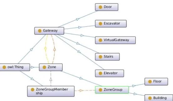
This model was inspired by the Composite design pattern [3], where zone groups are composites of zones representing recursive part-whole hierarchies (see Figure 3).
B. Ontology Definition
In computer science, the term "ontology" was introduced by Gru- ber [4] to mean "the specification of a conceptualization". This is a formal description of the concepts (entities with their attributes) and the relationships that exist in a given domain. The ILONA nav- igation domain ontology can be accessed via Protege [12], the web- based ontology editor that assists the creation and manipulation of ontologies. The knowledge representation language used for ontology
Fig. 3: The modeling of zone groups
construction is the Web Ontology Language (OWL 2) [10]. It pro- vides classes, properties, individuals, and data values on the syntax level. OWL ontologies are mapped to RDF graphs and stored as RDF documents.
The first task in ontology creation is to define the taxonomy of classes described by various attributes. In the ILONA ontology the top-most classes are Gateway and Zone with two attributes: name and id, where id refers to a value coming from the measurement component of the ILONA system. The five gateway types are imple- mented as subclasses of the Gateway class. The ZoneGroup class is derived from the Zone class and in order to represent zone groups as composites of zones an auxiliary class should be introduced to denote their relationship. This ZoneGroupMembership class connects each zone to a zone group. Since ZoneGroup is the derived class of the Zone class, this implies that zone groups can be members of other zone groups. Our model specifically defines two subclasses of the ZoneGroup class: Building and Floor to demonstrate the recursive part-whole hierarchy of floors in buildings. The proposed ontology model has not been fully implemented yet. As mentioned above, the grouping of Zones is possible according to several criteria apart from location (e.g. functionality: offices, laboratories, corridors, etc.; ownership: departments, faculties).
![Fig. 1: Subsystems of the ILONA System [16]](https://thumb-eu.123doks.com/thumbv2/9dokorg/1406189.118288/3.871.163.730.163.306/fig-subsystems-of-the-ilona-system.webp)
![Fig. 1: Subsystems of the ILONA System [16]](https://thumb-eu.123doks.com/thumbv2/9dokorg/1406189.118288/4.871.177.680.150.532/fig-subsystems-of-the-ilona-system.webp)