About performance requirements set against consumer-grade geolocation technologies
Ferenc Brachmann
University of Pécs Faculty of Sciences, Pécs, Hungary brachmann.ferenc@ttk.pte.hu
Abstract—With ever-newer forms of indoor geolocation coupled with the widely increasing number of location- based services, the requirements set towards consumer- grade geolocation technologies shows an ever broadening range. Typical consumer geolocation technologies are analyzed based on performance aspect for use with location- based services. The handling of challenges in RSSI-based technological solutions is elaborated. Based on findings of the analysis a comprehensive model for performance requirements of geolocation services is presented.
I. INTRODUCTION
The massive growth of consumer location-based services can be attributed to advances in manufacturing technologies enabling the availability of inexpensive hardware components providing the function of geolocation. Both specialized devices – like in-car navigation systems – and mobile handsets offering a wide range of functionality have been adapted by consumers in large numbers globally.
The heterogeneous nature of the technologies providing location information for smartphones presents challenges for software developers as well as handset manufacturers.
Providing the right type of location-information for location-based services can be a challenging with several key parameters needed to be taken into consideration. The most important parameters are:
• Power-consumption
A typical drawback of geolocation technologies is the power consumption of their use. Prolonged measurement activities will drain battery life and will not enable long- term use of these services rendering them useless. This high energy consumption is due to Time To First Fix (Dhondge et al. 2013).
• Time-To-First-Fix (TTFF)
The typical performance requirement towards geolocation services is it’s set-up time. This challenge is typical in satellite-based geolocation services and is a severe performance drawback of some of these technologies.
• Geographical accuracy
Precision of the geolocation process is essential for modern location-based services. With the need for ever increasing precision concerning this parameter, an ever increasing level of accuracy is required.
• Indoor coverage
With the widespread use of smartphones the requirement of indoor coverage and need for ever-increasing precision inside these closed, building environments is a hot topic for technology vendors and handset manufacturers alike.
With the ever-increasing use of these geolocation services, their quality parameters get more and more in focus of research and technological developments alike.
A. The process and actors of geolocation
The function of geolocation is an essential one for Location-Based Services since it provides the positioning data that these services rely on. We can define main roles (Küpper, 2005) of this process as follows:
(1) Target - An individual or a device whose position has to be located. This may be a device or a simple software service.
(2) Source: Equipment, network infrastructure or software service which provides the position information for the location-based service.
(3) Positioning System: Systems utilized to locate the position of the above Source; base stations for triangulation, position of satellites for GPS and other complementary services, such as systems designed to measure time delay, to ensure accuracy.
(4) Location-Based Service: An application, which utilizes the position information.
(5) Content Provider: It provides content for the above four actors, such as position of ATMs.
(6) User: An individual or another service, which utilizes Location Based Services. It may differ from the Target, e.g. tracking, controlling or fleet management services.
Regarding the method, the device is not important (or relevant) – it may be either GPS receiver or mobile phone, which can be positioned by triangulation – the above system is the same in each case.
In this model, the User receives only two- dimensional position information (disregarding the altitude data and other complementary information), the software of the Location Based Service needs to address the challenges and variance rising from the uncertainties of position information and as well as problems rising from the timing of the position information. Therefore, Location Based Services are fully dependent on the geolocation techniques and technologies used for the gathering of position information.
II. TYPICAL GEOLOCATION TECHNOLOGIES
In this model, the User receives only two-dimensional position information (disregarding the altitude data and other complementary information), the software of the Location Based Service needs to address the challenges and variance rising from the uncertainties of position information and as well as problems rising from the
– 309 –
ICSSE 2013 • IEEE International Conference on System Science and Engineering • July 4-6, 2013 • Budapest, Hungary
978-1-4799-0009-1/13/$31.00 ©2013 IEEE
timing of the position information. Therefore, Location Based Services are fully dependent on the geolocation techniques and technologies used for the gathering of position information.
This issue have been recognized by mobile platform vendors: both Google and Apple have been striving to provide a closed geolocation service for Location Based Service developers which enables position data transfer regardless of available technologies – concealing the deeper layers of their respective technologies. This approach is still only a halfway measure: Location-Based Services are not able to transfer their information requirements in a one-way question-answer format to the geolocation service. Position data – retrieved by this method – has no descriptive data content which would support application developers to enhance effectiveness and performance. In todays environment, the following types of geolocation services can be recognized:
A. Manual position entry
Location Based Services had existed before automated geolocation services appeared: the first Location Based Services – which utilized mobile phone position data – required manual data input (e.g. sending zip code via SMS) by the User. However, this simple technique had been quickly wiped out by mobile phones with GPS support by the beginning of the 2000's, but, unfortunately – as discussed below – manual data input is still included in today's Location Based Services.
It is a forgotten – but worth to mention – geolocation technique which is still utilized by almost every LBS application. Relevant POIs, object lists are displayed on the basis of position data and allows Users to choose the relevant object. This manual data input can be perceived as a comfort feature – actually it would be necessary in rare cases – but, as a matter of fact, this is developers' solution to conceal the defective-ness of technologies.
B. IP-based closed, automated systems
For the sake of completeness, it is essential to mention those closed and separate technologies, which locate a handset device's position from fix databases based on descriptive or authentic data. Among these, IP geolocation is the most popular solution. A huge challenge of this technique is that, although being fast, it is not supported by 3G/LTE network infrastructure since mobile network providers' IP address allocation is not based on the position of mobile devices. We have to emphasize the in- accuracies – rising from data quality – of this technique;
the extent of the deviation may be up to hundreds of kilometers. Another challenge worth mentioning is the varying nature of the handset’s IP address. With Wi-Fi networks being used by consumers and operators alike in an ever-increasing fashion, the IP address of a particular device can change in an ad-hoc fashion that effects the IP- based geolocation as well, making this form of geolocation a challenging and inaccurate technology.
C. Satellite-based geolocation technologies
There are several satellite networks in the world providing geolocation services, like the European Union’s Galileo positioning system, The Russian Global Navigation Satellite System (GLONASS), Chinese BeiDou Navigation Satellite System and India’s Regional Navigational Satellite System but the pioneer of these
technologies is the U.S.’s Global Positioning System (GPS). The introduction of satellite-based technologies into the consumer Location-Based Services space was a breakthrough in the field since it offered a quality data source with relatively low costs, that enabled significant functional and performance increases – compared to the previous geolocation technologies – and as well as a significant improvement of accuracy has been performed in the field of ad-hoc positioning of mobile devices.
This improvement in geolocation allowed for the significant functional and performance improvement of location-based services, like the introduction and wide global spread of automotive navigation systems. This technology has several challenges and burdens, which result in serious difficulties both in accuracy (up to a few meters) and both in the speed of receiving satellite signals (especially in difficult natural terrains and densely populated urban environments). The European Union's Galileo Program will probably bring a breakthrough in this field: although this technology will be significantly better in its functionality and performance compared to the GPS, however, its worldwide adaptation is still an issue since its challenging business model and the delayed satellite launches due to financial difficulties.
D. Technologies relying on land-based radio networks GPS technology – which is considered to be energy- consuming, slow, and inoperative in indoor environments and sensitive to weather conditions – made positioning more and more difficult to keep up with the improvement of other fundamental technologies that Location-Based Services rely on: it was necessary to develop new, alternative solutions. Improvements in handset performance required positioning technologies that have much faster reaction times and operation inside closed environments that is not possible with consumer-grade GPS components.
The first technology in this area is assisted GPS or A- GPS. The major improvement addressed with this technology is in the TTFF (Time-To-First-Fix) using location information of the cellular network. This technology was enabled by the requirement first formed by the Federal Communication Commission of the U.S.
for the location-information of cellular devices.
The most noteworthy technology among radio network- based geolocation technologies is Wi-Fi fingerprinting.
Several technology providers (SkyHook, probably the most important, with its database which consists of 250 million points and covers 70% of residential areas worldwide) try to address this issue by building massive, global Wi-Fi network databases on position data of mobile devices with active IEEE 802.11 device. Its speed to TTFF and low energy consumption is considered as the most important advantage of this technology. Both enhanced the wide expansion of hybrid geolocation technologies in urban areas.
There is also an important security issue regarding this technology: it may be easily mislead as the user may relocate its position – as positioning is based on the MAC addresses included in the databases – by means of an active IEEE 802.11 network device which is able to replicate MAC addresses.
F. Brachmann • About Performance Requirements Set against Consumer-Grade Geolocation Technologies
– 310 –
E. Other sensor-based systems
One exciting area of research is the utilization of some of the extra sensors (like accelerometers, cameras or even microphones) incorporated into handsets. The most vocal research covers magnetic anomaly-based indoor positioning. See Afzal et al. or Kim et al. for a detailed analysis. This approach uses the digital compass (or magnetometer) inside most consumer handsets to measure changes in the Earth’s magnetic field to provide the functionality of indoor positioning.
Although the technology – in theory – does not require any stationary hardware infrastructure present, it has to be noted that there is a high degree of variance in measurement results, see Brachmann (2012).
F. Hybrid positioning systems
The most exciting area of geolocation technologies are hybrid positioning systems. These approaches incorporate readings from several of the above-mentioned geolocation technologies to increase one or several performance aspects at once.
It is a forgotten – but worth to mention – geolocation technique which is still utilized by almost every LBS application. Relevant POIs, object lists are displayed on the basis of position data and allows Users to choose the relevant object. This manual data input can be perceived as a comfort feature – actually it would be necessary in rare cases – but, as a matter of fact, this is developers' solution to conceal the defective-ness of technologies.
III. TACKLING CHALLENGES IN RSSI-BASED APPROACHES
The above mentioned radio-, sensor- and hybrid positioning technologies all rely on some sort of signal measurement activities. These approaches named Received Signal Strength Indicator after the measured signal strength have significant technological disadvantages. These approaches also called wireless fingerprinting methods require some sort of training or calibration to build massive datasets to be used for comparison during the geolocation process. Several challenges need to be tackled during the process. These are:
• Reduction in calibration time
A typical technological drawback of RSSI-based approaches is a significant time to train or calibrate de measurement systems. Reducing calibration time is an essential challenge for geolocation technologies. Some interesting results have been published by Narzullaev et al. (2009) but calibration remains an integral component of these technologies.
• Increase in location accuracy
The performance gains in smartphone technologies are creating a demand for ever-increasing positional accuracy in geolocation technologies. To meet this demand, mathematical and statistical methods are called into action. Several approaches from normalization (see Marbán et al.) to proximity graphs (see Swangmuang- Krishnamurthy, 2008), to the complex approaches, like kth order location averaging (see Cha et al.) are present.
The analysis in Dawes- Chin (2011) analyses comparing probabilistic and deterministic models for RSSI-based indoor location fingerprinting shows that in environments
with high variability in signal strength it is challenging to provide the accuracy necessary for indoor location and removing transient APs from the fingerprint data is essential (using standard deviation cut-off) for providing accuracy.
IV. ANALISYS
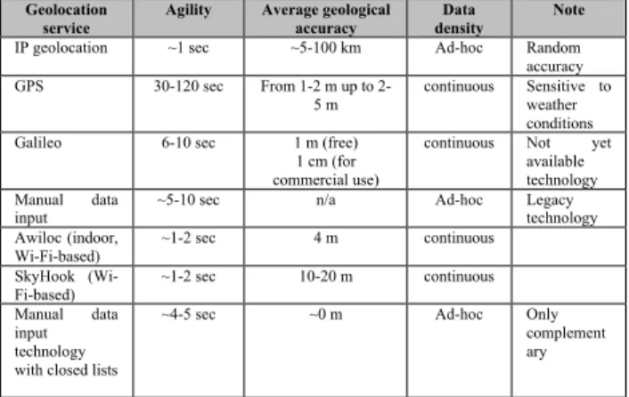
The table below summarizes the performance and accuracy parameters of the main geolocation technologies and techniques for analysis purposes.
Table 1: Main features of geolocation techniques and technologies Source: Brachmann (2012-2)
Geolocation
service Agility Average geological
accuracy Data
density Note
IP geolocation ~1 sec ~5-100 km Ad-hoc Random
accuracy
GPS 30-120 sec From 1-2 m up to 2-
5 m continuous Sensitive to weather conditions
Galileo 6-10 sec 1 m (free)
1 cm (for commercial use)
continuous Not yet available technology Manual data
input ~5-10 sec n/a Ad-hoc Legacy
technology Awiloc (indoor,
Wi-Fi-based) ~1-2 sec 4 m continuous
SkyHook (Wi- Fi-based)
~1-2 sec 10-20 m continuous
Manual data input technology with closed lists
~4-5 sec ~0 m Ad-hoc Only
complement ary
Based on the data figures, it is concluded that – compared to the data requirements of Location-Based Services, geolocation services currently available on the market are crude, have low efficiency and performance parameters, therefore, it is necessary to develop and introduce such geolocation technologies which are able to fill the gaps of hybrid technologies and communicate the quality information necessary for high-quality location- based services.
V. ABOUT GEOLOCATION INFORMATION REQUIREMENTS OF LOCATION BASED SERVICES
Each Location Based Service has different geolocation information requirement – depending on its different functionality and provided data content. This fact is not considered – or only partly considered – by these technologies therefore there is a need to develop a model which is able to address quantity and quality issues of position data transfer.
Table 2: Geolocation requirements of Location Based Services Source: Brachmann (2012-2)
Type TTFF
requirement
Geographical accuracy requirement
Data density
Other features
Example
Tier-1 1 sec (quasi
real time) ‹ 1 m Real
time - Military systems, industrial/logistica l systems with high availability requirements
Tier-2 5-10 sec 2-5 m 5 sec - Location based
games, augmented reality, navigation
Tier-3 10-20 sec 5-10 m 20 sec It
requires mainly manual data input
LBSs for
entertainment purposes
Tier-4 30-60 sec 10-20 m 60 sec - Fleet management,
tracker applications
Tier-5 Ad-hoc 10-20 m Ad-hoc - LBS applications
with simple 'check in' feature
Tier-6 Ad-hoc 1 km Ad-hoc - Geolocation of
social media contents
– 311 –
ICSSE 2013 • IEEE International Conference on System Science and Engineering • July 4-6, 2013 • Budapest, Hungary
Table 2 presents a model – developed on the basis of our own studies – to summarize geolocation information requirements of Location Based Services. It clearly shows that both in agility and both in geographical accuracy there is a significant variance regarding almost all the applicable services. Based on this fact, we can conclude that a significant improvement will probably be available to enhance the quality of Location Based Services from both aspects.
VI. CONCLUSIONS, FUTURE WORK
Based on the findings, the following conclusions should be noted:
1. Based on fresh research results, hybrid positioning systems present a significant measure of improvement over stand-alone technologies both in indoor and outdoor environments alike.
2. There is still no definite consumer-grade geolocation technology applicable in indoor environments.
3. The mathematical and statistical methods to tackle RSSI-variance problem needs further research.
The following future avenues of future research are planned:
1. A hybrid geolocation technology using several techniques to tackle the RSSI variance problem could yield
2. Furthermore a geolocation technology that varies geolocation information quality based on the requirements of the location-based service is proposed. Besides TTFF improvements, decrease in power consumption is also a likely implication without a decrease in quality-of-servie.
3.
ACKNOWLEDGMENT
This research was enabled by the financial support from the SROP-4.2.2.C-11/1/KONV-2012-0005, project named: “Well-being in the Information Society”
supported by the European Social Fund.
REFERENCES
[1] Kaustubh Dhondge, Hyungbae Park, Baek-Young Choi, Sejun Song, “ECOPS: Energy-Efficient Collaborative Opportunistic Positioning for Heterogeneous Mobile Devices”, Journal of Computer Networks and Communications Volume 2013, Article ID 136213, 13 pages
[2] Afzal, M.H., Renaudin, V., Lachapelle, G., “Assessment of indoor magnetic field anomalies using multiple magnetometers”, 23rd International Technical Meeting of the Satellite Division of the Institute of Navigation 2010, ION GNSS 2010 1 , pp. 525-533, 2010
[3] Kim, S.-E., Kim, Y., Yoon, J., Kim, E.S., “Indoor positioning system using geomagnetic anomalies for smartphones”, 2012 International Conference on Indoor Positioning and Indoor Navigation, IPIN 2012 - Conference Proceedings , art. no.
6418947, 2012
[4] Brachmann, F., “A comparative analysis of standardized technologies for providing indoor geolocation functionality”, 13th IEEE International Symposium on Computational Intelligence and Informatics CINTI(2012), 2012
[5] Brachmann, F., “Helyzetalapú szolgáltatások geolokalizációs információ- igényének klasszifikációja”, AZ ELMÉLET ÉS A GYAKORLAT TALÁLKOZÁSA A TÉRINFORMATIKÁBAN, Debrecen, Hungary, 2012.05.24-2012.05.25., Debrecen University Press, ISBN:978-963-318-218-5, 2012., pp. 81-88
[6] Hamdy, Y.R., Mawjoud, S.A., “Performance assessment of U- TDOA and A-GPS positioning methods”, 2012 International Conference on Future Communication Networks, ICFCN 2012, art. no. 6206882 , pp. 99-104 , 2012
[7] López, J.M.L., Aguilar, F.L., Abascal, J.J.C. “A-GPS performance in urban areas”, Lecture Notes of the Institute for Computer Sciences, Social-Informatics and Telecommunications Engineering 77 LNICST, pp. 413-422, 2012
[8] Anvar Narzullaev, Yongwan Park, Kookyeol Yoo, Jaehwang Yu,
“A fast and accurate calibration algorithm for real-time locating systems based on the received signal strength indication”, International Journal of Electronics and Communications (AEÜ), vol. 65 (2011) pp. 305–311
[9] Luis Mengual, Oscar Marbán *, Santiago Eibe, “Clustering-based location in wireless networks”, Expert Systems with Applications, vol. 37 (2010), pp. 6165–6175
[10] Nattapong Swangmuang, Prashant Krishnamurthy, “An effective location fingerprint model for wireless indoor localization”, Pervasive and Mobile Computing vol. 4 (2008), pp. 836–850 [11] Yungeun Kim, Hyojeong Shin, Yohan Chon, Hojung Cha,
“Smartphone-based Wi-Fi tracking system exploiting the RSS peak to overcome the RSS variance problem”, Pervasive and Mobile Computing, article in press
[12] Brett Dawes, Kwan-Wu Chin, “A comparison of deterministic and probabilistic methods for indoor localization”, The Journal of Systems and Software vol. 84 (2011) pp. 442–451
F. Brachmann • About Performance Requirements Set against Consumer-Grade Geolocation Technologies
– 312 –