1. Introduction
The stratigraphy and sedimentary environments of impact crater interior sedimentary fill form valuable cli- mate archives on Earth, in particular those in young impact structures such as Bosumtwi and El’gygytgyn.
Only a few terrestrial impact structures with preserved sedimentary fill are known. These are primari- ly present-day crater lakes such as Pingualuit, Bosumtwi, El’gygytgyn, and Tswaing (Guyard et al., 2011;
Melles et al., 2012; Partridge et al., 1993; Shanahan et al., 2009; Talbot & Johannessen, 1992). These crater fill deposits precisely record Quaternary climate changes, such as aridification or glacial cycles, as revealed by geochemistry, stable isotopes, and palynomorphs (Melles et al., 2012; Shanahan et al., 2009; Talbot & Jo- hannessen, 1992). Fossil examples, however, are commonly buried (Boltysh: Gurov et al., 2006; Chesapeake
Abstract
Since its recognition as an impact structure 60 years ago, no volcanics were anticipated in the circular depression of the 14.8 Ma old Nördlinger Ries. Here, we describe for the first time a volcanic ash-derived clinoptilolite-heulandite-buddingtonite bed within the 330 m thick Miocene lacustrine crater fill. Zircon U-Pb ages of 14.20 ± 0.08 Ma point to the source of the volcanic ash in the Pannonian Basin, 760 km east of the Ries. The diagenetically derived zeolite-feldspar bed occurs in laminated claystones of the Ries soda-lake stage and represents the first unequivocal stratigraphic marker bed in this basin, traceable from marginal surface outcrops to 218 m below surface in the crater center. These relationships demonstrate a deeply bowl-shaped geometry of crater fill sediments, not explainable by sediment compaction and corresponding stratigraphic backstripping alone. Since most of the claystones formed at shallow water depths, the bowl-shaped geometry must reflect 134 +23/−49 m of sagging of the crater floor. We attribute the sagging to compaction and closure of the dilatant macro-porosity of the deeply fractured and brecciated crater floor during basin sedimentation and loading, a process that lasted for more than 0.6 Myr. As a result, the outcrop pattern of the lithostratigraphic crater-fill units in its present erosional plane forms a concentric pattern. Recognition of this volcanic ash stratigraphic marker in the Ries crater provides insights into the temporal and stratigraphic relationships of crater formation and subsidence that have implications for impact-hosted lakes on Earth and Mars.Plain Language Summary
We describe for the first time a volcanic ash layer from the lake sediment fill of the 14.8 million years old asteroid impact crater Nördlinger Ries. Radiometric age and trace element characteristics of this ash layer are identical to that of a volcanic field in Hungary, so that the ash reflects a volcanic eruption 760 km east of the Ries basin. Recognition of this ash layer enables its use as a marker bed. The ash layer can be traced from surface outcrops to 218 m depth in drillings.This indicates that the strata are significantly inclined toward the crater center. Calculations of sediment compaction by further sediment load and burial only partially explain the observed deeply bowl-shaped geometry. We attribute the additional sagging to the subsidence of the crater floor substrate, formed of rocks highly shattered by the impact event. Both effects cause a concentric pattern of outcropping strata in the partially eroded crater fill. The presence of the ash layer and its use to help disentangle the source and timing of subsidence (due to compaction of lake sediments, and closure of deeper, impact-induced fractures), has important implications for lakes formed in impact craters on Earth and Mars.
© 2021. The Authors.
This is an open access article under the terms of the Creative Commons Attribution License, which permits use, distribution and reproduction in any medium, provided the original work is properly cited.
Geometry and Origins of Long-Term Crater Floor Sagging
Gernot Arp1 , István Dunkl1 , Dietmar Jung2, Volker Karius1 , Réka Lukács3 , Lingqi Zeng1 , Andreas Reimer1, and James W. Head III4
1Geoscience Center, Georg-August-University, Göttingen, Germany, 2Geological Survey, Bavarian Environment Agency, Hof/Saale, Germany, 3MTA-ELTE Volcanology Research Group, Budapest, Hungary, 4Department of Earth, Environmental and Planetary Sciences, Brown University, Providence, RI, USA
Key Points:
• A critical question in the evolution of impact-crater-hosted lakes is the origin and timing of post-impact floor subsidence
• We describe a volcanic ash layer from the Ries impact crater that demonstrates a deeply bowl-shaped geometry of its lacustrine crater fill
• This geometry, leading to a concentric outcrop pattern, requires significant crater floor sagging, in addition to sediment compaction
Supporting Information:
Supporting Information may be found in the online version of this article.
Correspondence to:
G. Arp, garp@gwdg.de
Citation:
Arp, G., Dunkl, I., Jung, D., Karius, V., Lukács, R., Zeng, L., et al. (2021).
A volcanic ash layer in the Nördlinger Ries impact structure (Miocene, Germany): Indication of crater fill geometry and origins of long- term crater floor sagging. Journal of Geophysical Research: Planets, 126, e2020JE006764. https://doi.
org/10.1029/2020JE006764 Received 6 NOV 2020 Accepted 5 MAR 2021
Bay: Gohn et al., 2008) or significantly eroded (Steinheim: Reiff, 1977; Haughton: Osinski et al., 2005). In a similar manner, lacustrine crater fill deposits on Mars potentially form archives of the climatic develop- ment throughout Mars history, and particularly during the Noachian-Hesperian climate transition, when Mars changed from at least episodically warm to the current extremely cold and arid conditions (for review see e.g. Carr & Head, 2010a, 2010b; Craddock & Howard, 2002; Fassett & Head, 2008a, 2008b; Grotzinger
& Milliken, 2012; Goudge et al., 2015, 2016; Irwin et al., 2005; Milliken et al., 2010). We report here on the discovery and documentation of a volcanic-ash derived marker bed in the Nördlinger Ries impact structure that we use to outline the nature of the subsidence history of the crater lake floor, and the origin and timing of the observed bowl-shaped crater fill geometry with significantly inclined strata. We explore some impli- cations for the history of other crater lakes on Earth and Mars.
2. The Nördlinger Ries Structure and Stratigraphy
The Nördlinger Ries is a 14.808 ± 0.038 Ma old (Middle Miocene) (Schmieder et al., 2018a; for discussion see Rocholl, Böhme, et al., 2018; Rocholl, Schaltegger, et al., 2018 and Schmieder et al., 2018b), partially ex- humed impact crater, structurally subdivided into a central crater, an inner ring, and a marginal block zone delineated by the tectonic crater rim (Figure 1; Pohl et al., 1977). The impact occurred in volatile-rich target rocks (Artemieva et al., 2013; Osinski, 2004, 2006). Two ejecta blankets are distinguished: 1) the Bunte Brec- cia (showing a rampart structure; Sturm et al., 2013) and 2) the overlying impact-melt bearing suevite (Hüt- tner, 1969; Stöffler et al., 2013; Siegert & Hecht, 2019; Siegert et al., 2017; von Engelhardt, 1997). By the end of the Miocene (∼5.33 Ma), the Ries crater was completely covered by sediments (Schröder & Dehm, 1950), and subsequently, Plio- to Pleistocene erosion removed about 100 m of sediment within the crater as well as parts of the ejecta blankets (Hüttner, 1969; Wolf, 1977). The sedimentary fill preserved today consists of four lithostratigraphic units (Jankowski, 1977a, 1981):
(i) The basal member: Consists of conglomerates and sandstones derived from suevite and crystalline basement rocks, with intercalated playa deposits
(ii) The laminite member: Comprised of laminated marls and bituminous shales, with authigenic silicates (analcime, clinoptilolite) and abundant slumping structures
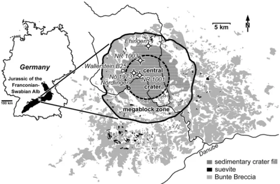
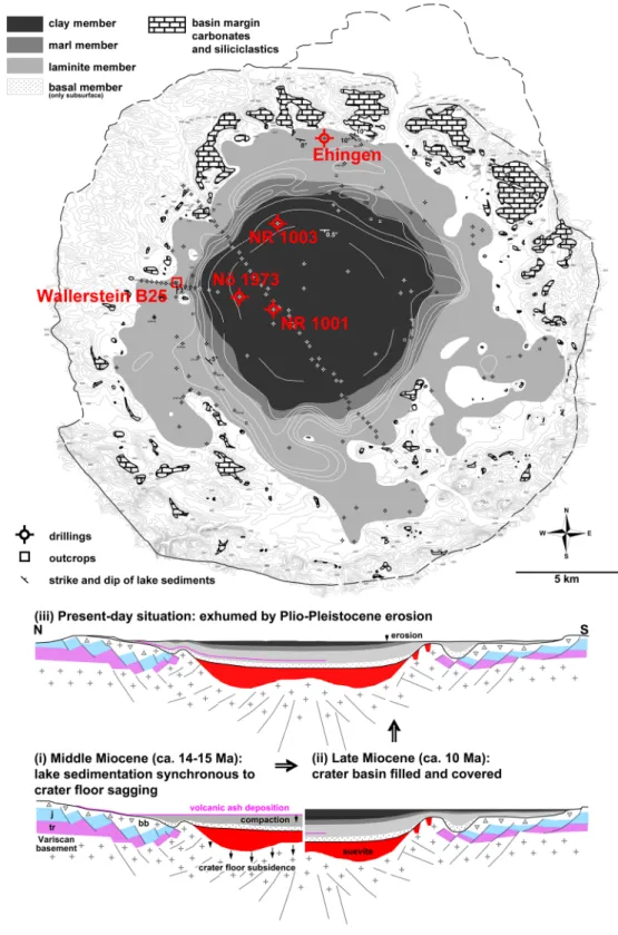
Figure 1. Location of the outcrop Wallerstein B25, the investigated drillings NR 1001, NR 1003, Nö 1973, Ehingen, and major structural elements of the Ries impact structure (based on Ernstson, 1974; Hüttner & Schmidt-Kaler, 1999; Pohl et al., 1977).
(iii) The marl member: Characterized by stratified calcareous claystones and poorly bedded dolomitic marls. These are partially bioturbated and contain analcime only sporadically
(iv) The clay member: The youngest preserved unit consists of an alternation of clays, marls and lime- stones, with intercalated carbonaceous clays, lignites, and gypsum-pseudomorph-bearing limestones While these units can be recognized in drill cores of the central crater basin, sections in marginal positions (short drill cores, rotary drillings, and temporary exposures) are more difficult to assign to specific units.
Therefore, the surface outcrop pattern of these units, the basin-center to basin-margin correlations, and consequently, the crater fill geometry, has remained poorly constrained and a matter of controversy in the literature (Arp et al., 2013; Jankowski, 1981; Schauderna, 1983; Wolff & Füchtbauer, 1976). The volcanic-ash derived marker bed that we describe here was discovered in a temporary exposure during the construction of a state road B 25 underpass in the western Ries basin near Wallerstein (Figure 1; Text S1). Subsequently, the same bed was found in a percussion drill core at northern Ries basin margin (Ehingen-SE), and in three drill cores from the basin center (Figure 1; Text S1). We outline the characteristics and distribution of this volcanic-ash-deposited marker bed and use these data to help constrain the filling and subsidence history of the Nördlinger Ries crater lake.
3. Materials and Methods
Five samples of the outcrop Wallerstein B25, three samples of the drill cores Nördlinger Ries 1001, 1003 and Nördlingen 1973, 22 samples of percussion drill core Ehingen-SE, one sample from Ehinger Bach (Fig- ure 1), and five reference samples from the Northern Alpine Foreland Basin and the Leinetal Graben have been investigated (Text S2 and Data Set S1).
The mineralogical composition (Text S2) was analyzed by powder X-ray diffraction using a Philips PW 1800 diffractometer operating at 45 kV and 40 mA with monochromated Cu Kα radiation. The range 4°2θ–70°2θ was scanned with a step width of 0.02°2θ. The counting time was 3 s per step. Mineral identification was carried out using the X’Pert High-Score Plus software (PANalytical). Quantification of mineral phases was performed by Rietveld calculations using the program AutoQuant.
The elemental composition of the samples (Data Set S1) was determined by X-ray fluorescence analysis (PANalytical Axios Advanced XRF spectrometer fitted with a 4 kW Rh anode SSTmAx X-ray tube) on glass fusion disks. Samples with high S and Corg contents were previously heated at 650°C for 3 h in a furnace.
Total carbon, nitrogen, and sulfur were analyzed with a Euro EA 3000 Elemental Analyzer (Hekatech, Wegberg, and Germany) applying BBOT (2.5-Bis [5-tert-benzoxazol-2-yl] thiophene) and atropine sulfate monohydrate (IVA Analysetechnik, Meerbusch, Germany) as reference materials. Organic and inorganic carbon content was separated using a gradual heating method on a LECO RC612 multi-phase carbon ana- lyzer (Leco, St Joseph, MI, USA), calibrated against LECO carbon standards (1.00%C, 4.98%C, and 12.00%C).
Laser ablation ICP-MS U-Pb dating of the volcanogenic zircon crystals was performed in the GÖochron Laboratories of University of Göttingen. The details of the laboratory procedure is in the Text S3 and Data Set S2.
Modeling of compaction and stratigraphic backstripping (Data Set S3 and S4) was calculated on basis of the Athy equation (Athy, 1930; Sclater & Christie, 1980), modified by Maillart (1991):
Z res 0res e z ,
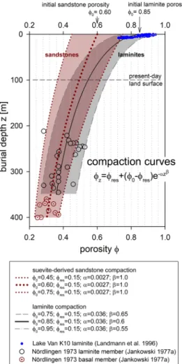
with ϕ0 = porosity at time of deposition, ϕz = porosity at burial depth z (m), ϕres = residual porosity, and α and β empirical compaction coefficients. The reason for using the modified equation is that the Maillart equation introduces a “residual porosity” ϕres to account for remaining porosities at greater depths (see e.g., Einsele, 2000; Revil et al., 2002), and an additional coefficient β, which is required for a fitting to measured porosities at near surface depth (specifically during early dewatering of laminites). The curve for pelitic sediments (Figure 2) was aligned to measured porosities in laminites of the drill core Nördlingen 1973 (Jankowski, 1977a) and porosities in surface sediments of Lake Van (Data Set S3; Landmann et al., 1996 and Reimer et al., 2009) by modifying the empirical compaction coefficients α and β. The varved Lake Van
sediments (Landmann et al., 1996; Stockhecke et al., 2014) are similar to the laminites of the Ries (Bolten et al., 1976; Jankowski, 1981; We- ber, 1941) with respect to carbonate contents and lamination (alternation of light carbonate-rich, and dark Corg− and clay-rich laminae; similar laminae thickness). As a measure for uncertainty, the compaction was also calculated for ±10% initial porosity (at z = 0). The compaction curve for sandstones (Figure 2) was calculated in the same way, with an initial porosity of 0.60, that is, intermediate between 0.45 for pure sand (Beard
& Weyl, 1973) and the very high value of 0.75 as used e.g. in Kominz and Pekar (2001). The ratio of present-day ϕz and ϕz at the time of zeolite bed deposition was used for stratigraphic backstripping of the sediment col- umn below the zeolite bed, subdivided in 1 m thick intervals. The surface distribution pattern of lithofacies units was compiled from percussion corings, diploma thesis mapping, unpublished and published drilling re- ports, and data from the drill database BIS Bayern (Data Set S5).
4. Results
4.1. Composition, Age and Source of the Volcanic Ash
Construction of the Wallerstein B25 state road underpass in the western Ries basin (Figure 1) exposed, at 440 m a.s.l., a 14 cm thick white porous and light zeolite bed intercalated between aragonite-bearing laminites.
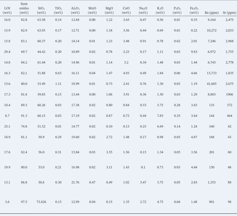
Quantitative XRD analyses demonstrate that the zeolite bed largely con- sists of clinoptilolite (63 wt%) and heulandite (34 wt%), with only traces of other minerals (quartz). The zeolite bed shows a 2 cm thick graded basal layer, with clinoptilolite (45 wt%), heulandite (29 wt%), smectite (8 wt%), plagioclase, quartz, muscovite and biotite. Allanite and zircon were found in the heavy mineral fraction. The black, idiomorphic biotite crys- tals display a grain-size gradation within the basal layer (Figure 3): The majority of the bed is massive with only a faint stratification at its top.
Geochemically, the zeolite bed is very rich in SiO2 and shows high Ba contents (Table 1).
The same zeolite bed has been detected by percussion coring at the north- ern margin of the central basin, SE of Ehingen (Figure 1). A clinoptilo- lite-heulandite bed was previously mentioned at this locality from ma- terial excavated in a construction pit (Wolff, 1974). Our re-investigation at this locality revealed the presence of a 15 cm thick clinoptilolite-heu- landite bed at 4 m depth, that is at 424 m a.s.l., intercalated between aragonite-bearing laminites. Here, the aragonitic component could be identified as being formed by elongated fecal pellets (80–90 µm diame- ter; 400–650 µm length), probably produced by the brine shrimp Artemia (Jankowski, 1981). The mineralogical and geochemical composition of the bed, including a graded base with biotite crystals, is identical to the clinoptilolite-heulandite bed at the Wallerstein B25 underpass (Table 1).
Pink, euhedral, intact zircon crystals of 125–275 µm in size, extracted from the zeolite bed at Wallerstein B 25, revealed a 14.20 ± 0.08 Ma con- cordant U-Pb age (Table 2). This age is undistinguishable from that of the Harsány ignimbrite, a rhyolithic tuff of the Bükkalja Volcanic Field in Hungary (Lukács et al., 2015, 2018) and a bentonite bed located 53 km southeast of the Ries crater in the North Alpine Foreland Basin (Table 2;
Text S3 and Data Set S2). In contrast, all other Cenozoic volcanic fields in Europe (Hegau and Urach, Kaiserstuhl, Eifel, Eger Rift, Vogelsberg and Hessian Depression, Massif Central) differ in chemistry and age (e.g., Figure 2. Compaction curves used in this study for back-stripping the
position of the volcanic-ash-derived zeolite-feldspar bed in the Ries Crater Lake. For calibration, porosity data of Jankowski (1977a) and Landmann et al., (1996) were used. For details of calculations see Data Set S3.
Figure 3. (a) Basal part of the volcanic-ash derived zeolite bed at Wallerstein B 25, showing black biotite crystals within a zeolite matrix.
(b) Scanning electron micrograph of the same sample showing monoclinic clinoptilolite-heulandite crystals.
Wörner et al., 1986; Wedepohl, 2000; for review see; Lustrino & Wilson, 2007) from the investigated samples.
Therefore, the Ries zeolite bed is interpreted to be a distal volcanic ash from the Bükkalja Volcanic Field in the Pannonian Basin, 760 km east of the Nördlinger Ries crater, and equivalent to one of the bentonite horizons in the Northern Alpine Foreland Basin (NAFB), specifically that of Unterzell (Table 1).
Previous geochemical analysis by Unger et al. (1990) suggested that volcanism in the Pannonian Basin was the source of the NAFB bentonites, and also recently Lukács et al. (2018) suggested a correlation with the Bükkalja Volcanic Field pyroclastics based on U-Pb zircon data. However, none of the recently dated NAFB bentonites (U- Pb dating by CA-ID-TIMS; Rocholl, Schaltegger, et al., 2018) revealed an identical age to the Unterzell bentonite investigated in this paper (U-Pb dating by LA-ICP-MS; Table 2), certainly reflecting the higher accuracy of the chemical abrasion (CA-ID-TIMS) method.
4.2. Stratigraphic Correlation From Surface to Depth
A re-inspection of drill cores NR 1001, NR 1003 and Nördlingen 1973 revealed a volcanic ash-derived bed at 192–218 m core depth, within the deeper part of the laminite member (Figure 4). Similar to its equivalents in the surface outcrops, the bed is intercalated within laminated organic-rich calcareous mudstones character- ized by abundant aragonitic brine shrimp fecal pellets, typical of the analcime submember (Jankowski, 1981).
However, in the drill samples the bed consists of K-NH4-feldspar (buddingtonite; Table 1), a diagenetic succes- sor derived from zeolites during burial and microbial ammonification in organic-rich sediments (Ramseyer et al., 1993). Geochemically, the bed is SiO2-rich, as is the zeolite precursor, but contains K+ and NH4+ instead of Ba2+ (Table 1). Based on the correlation of this volcanic-ash-derived silicate bed from marginal surface outcrops at 440–424 m a.s.l. to basin center drillings at 236-206 m a.s.l., a bowl-shaped crater fill geometry becomes evident (Figure 5), with the laminite member cropping out at the central basin margin, and younger crater fill units confined to drilling samples from the middle of the central basin.
4.3. Concentric Outcrop Pattern
The compilation and interpretation of drill data and exposures demonstrate that the surface outcrop of sedimentary crater fill members can be traced in a concentric pattern (Figure 6, Data Set S5):
(i) The basal member is readily identifiable in drilling samples, although the temporal relation to basin margin conglomerates and sandstones remains unclear. However, the latter commonly predate bio- herms and travertines of later lake stages, and are slightly inclined toward the basin center. Therefore, they largely correspond to an early phase of basin development
(ii) The laminite member crops out in a broad fringe at the periphery of the central basin and in sub- basins of the megablock zone. Temporary surface exposures show a 3°–10° inclination toward the basin center, with only one slump-related exception (Figure 6, Data Set S5). Bituminous shales in- tercalated in the basal parts of this member (i.e., at more than 245 m core depth in the basin center), crop out at the outermost margin of the central Ries plain (localities Wengenhausen, Nördlin- gen-Freibad, Goldberg, Ehingen). Basin-margin equivalents of the laminite member consist of early algal bioherms, and tufa mounds (“travertines”), which formed predominantly subaqueously in a soda lake environment, as determined from the characteristic sickle-cell-like shrinkage void fabric (Arp et al., 1998, 2010). Similarly, specific biogenic components in the tufa mounds, such as brine shrimp fecal pellets and dragon fly larvae, are known only from intervals of the laminite member (Dehm et al., 1977).
(iii) The marl member shows only a limited number of unequivocal surface outcrops (Hollaus, 1969) locat- ed at northern-central Ries. However, drillings demonstrate that this member can be traced as an ∼500 m-wide circular strip in the central basin. Some of the basin-margin algal bioherms (e.g., at Adlersberg; Arp et al., 2013) may be equivalent to this unit.
(iv) Drilling samples and temporary exposures demonstrate that the clay member is restricted to the inner part of central Ries plain (Deffner & Fraas, 1877; Kranz, 1952). Basin margin equivalents are probably late algal bioherms (e.g., at Hainsfarth; Arp et al., 2013) and relict occurrences of oolites and freshwater limestones at hills near the crater rim.
Table 1
Mineralogical and Geochemical Composition of the Volcanic-Ash-Derived Zeolite-Feldspar Bed in the Miocene Ries Crater Lake Sediments and Reference Samples
Location Sample number Depth
(m bs) Altitude (m
asl) Mineral phases a XRD
(semiquant. wt%) Corg (wt%) Ccarb (wt%) Ntot (wt%) Stot (wt%) LOI (wt%)
oxides Sum (wt%) SiO2
(wt%) TiO2
(wt%) Al2O3
(wt%) MnO
(wt%) MgO
(wt%) CaO
(wt%) Na2O
(wt%) K2O
(wt%) P2O5
(wt%) Fe2O3
(wt%) Ba (ppm) Sr (ppm) Wallerstein B25
underpass 2015 Wal-B25 C 0.83 439.2 Cpt (52), Hul (43), Mag
(3), Qz (2) 0.02 <0.003 0.011 0.002 16.0 82.8 63.58 0.14 12.84 0.00 1.22 3.65 0.47 0.56 0.01 0.35 9,164 2,475
Wallerstein B25
underpass 2015 Wal-B25 B 0.84 439.2 Cpt (57), Hul (38), Mag
(3), Qz (1) 0.02 <0.003 0.010 0.002 15.9 82.9 63.93 0.17 12.71 0.00 1.18 3.56 0.44 0.69 0.01 0.22 10,272 2,033
Wallerstein B25
underpass 2015 Wal-B25 A 0.94 439.1 Cpt (45), Hul (29), Pl
(9), Sme (8), Bt (2) 0.03 <0.003 0.009 0.256 15.8 83.1 60.37 0.20 14.14 0.01 1.23 3.48 0.91 0.78 0.02 2.01 7,246 2,968
Ehingen-SE percussion
drill core 2015 Eh 11 4.01 424.0 Cpt (54), Hul (20), Gth
(16), Ilt (6) 0.09 0.007 0.010 0.028 29.4 69.7 44.42 0.20 10.89 0.02 0.78 2.23 0.17 1.11 0.03 9.83 6,972 1,755
Ehingen-SE percussion
drill core 2015 Eh 12 4.08 423.9 Cpt (57), Hul (30), Gth
(4), Ilt (4) 0.03 0.007 0.009 0.008 14.8 84.2 61.44 0.20 14.96 0.01 1.14 3.2 0.34 1.48 0.03 1.44 6,743 2,778
Ehingen-SE percussion
drill core 2015 Eh 13 4.14 423.9 Cpt (31), Hul (17), Ilt
(16), Sme (14) 0.32 0.65 0.034 0.260 16.3 82.1 51.88 0.63 16.11 0.04 1.47 4.93 0.49 1.84 0.06 4.66 13,733 1,835
Ehingen-SE percussion
drill core 2015 Eh 14 4.15 423.9 n.a. 0.03 0.01 0.008 0.463 15.6 80.0 53.49 1.11 18.99 0.01 0.73 2.41 0.76 1.30 0.03 1.19 41,605 2,675
Ehinger Bach 1969
(sample Wolff) EhB 0.0 424.0 Cpt (60), Hul (35), Mag
(3), Qz (2) 0.10 0.16 0.024 0.005 17.3 81.6 59.85 0.15 13.44 0.00 1.06 3.91 0.36 1.50 0.03 1.29 8,803 1906
drill core Nördlingen
1973 Noe1973-71 218.5 208.6 Bud, Kfs, Ab, Qz 1.57 0.06 2.642 0.040 10.4 89.5 60.26 0.03 17.38 0.02 0.80 0.84 0.53 5.75 0.28 3.65 135 372
drill core Nördlinger
Ries 1001 Noe1001-1 206.7 213.4 Bud, Kfs, Ab, Qz 1.57 <0.003 1.970 0.139 8.7 91.3 60.15 0.03 17.19 0.02 0.87 0.73 0.44 7.85 0.35 3.64 144 464
drill core Nördlinger
Ries 1003 Noe1003-82 192.7 236.4 Bud, Kfs, Ab 0.37 <0.003 2.460 0.211 25.1 74.8 51.52 0.01 14.77 0.02 0.10 0.13 0.23 6.69 0.14 1.24 160 42
bentonite Ammersberg, Northern Alpine Foreland Basin
AM2 8.0 485 n.a. 0.01 0.01 0.008 <0.002 18.9 81.1 50.9 0.29 19.60 0.02 2.72 1.48 0.17 0.98 0.05 4.87 168 43
bentonite Unterzell, Northern Alpine Foreland Basin
UZ1 7.0 499 n.a. 0.01 0.01 0.011 <0.002 17.6 82.4 56.0 0.31 15.84 0.03 3.55 1.56 0.15 1.34 0.05 3.56 201 60
bentonite Unterzell, Northern Alpine Foreland Basin
UZ2 7.0 499 n.a. 0.01 0.02 0.007 <0.002 19.9 80.0 53.0 0.21 16.98 0.02 3.11 1.43 0.1 0.73 0.03 4.44 150 48
Laacher See Tuff, Bringberg, 14 km S of Göttingen
LST 0.0 193 Qz (47), Clc (27), Bt
(19), Mag (6) 0.27 <0.003 0.027 0.008 13.1 86.8 50.6 0.30 21.76 0.47 0.49 1.02 5.47 3.75 0.05 2.85 1,353 88
Tibolddaróc, Harsány Ignimbrit Unit, layer A b
Td-A = DX 46 n.a. n.a. n.a. n.a. n.a. 3.6 97.5 73.826 0.15 12.99 0.04 0.15 1.35 2.72 4.75 0.04 1.48 901 98
n.a., not analyzed; b.d.l., below detection limit.
aMineral name abbreviations according to Whitney and Evans (2010), except for Buddingtonite (Bud). bAverage bulk composition of pumice clasts, data published in Lukács et al. (2007, 2015).
Table 1 Continued
Location Sample number Depth
(m bs) Altitude (m
asl) Mineral phases a XRD
(semiquant. wt%) Corg (wt%) Ccarb (wt%) Ntot (wt%) Stot (wt%) LOI (wt%)
oxides Sum (wt%) SiO2
(wt%) TiO2
(wt%) Al2O3
(wt%) MnO
(wt%) MgO
(wt%) CaO
(wt%) Na2O
(wt%) K2O
(wt%) P2O5
(wt%) Fe2O3
(wt%) Ba (ppm) Sr (ppm) Wallerstein B25
underpass 2015 Wal-B25 C 0.83 439.2 Cpt (52), Hul (43), Mag
(3), Qz (2) 0.02 <0.003 0.011 0.002 16.0 82.8 63.58 0.14 12.84 0.00 1.22 3.65 0.47 0.56 0.01 0.35 9,164 2,475
Wallerstein B25
underpass 2015 Wal-B25 B 0.84 439.2 Cpt (57), Hul (38), Mag
(3), Qz (1) 0.02 <0.003 0.010 0.002 15.9 82.9 63.93 0.17 12.71 0.00 1.18 3.56 0.44 0.69 0.01 0.22 10,272 2,033
Wallerstein B25
underpass 2015 Wal-B25 A 0.94 439.1 Cpt (45), Hul (29), Pl
(9), Sme (8), Bt (2) 0.03 <0.003 0.009 0.256 15.8 83.1 60.37 0.20 14.14 0.01 1.23 3.48 0.91 0.78 0.02 2.01 7,246 2,968
Ehingen-SE percussion
drill core 2015 Eh 11 4.01 424.0 Cpt (54), Hul (20), Gth
(16), Ilt (6) 0.09 0.007 0.010 0.028 29.4 69.7 44.42 0.20 10.89 0.02 0.78 2.23 0.17 1.11 0.03 9.83 6,972 1,755
Ehingen-SE percussion
drill core 2015 Eh 12 4.08 423.9 Cpt (57), Hul (30), Gth
(4), Ilt (4) 0.03 0.007 0.009 0.008 14.8 84.2 61.44 0.20 14.96 0.01 1.14 3.2 0.34 1.48 0.03 1.44 6,743 2,778
Ehingen-SE percussion
drill core 2015 Eh 13 4.14 423.9 Cpt (31), Hul (17), Ilt
(16), Sme (14) 0.32 0.65 0.034 0.260 16.3 82.1 51.88 0.63 16.11 0.04 1.47 4.93 0.49 1.84 0.06 4.66 13,733 1,835
Ehingen-SE percussion
drill core 2015 Eh 14 4.15 423.9 n.a. 0.03 0.01 0.008 0.463 15.6 80.0 53.49 1.11 18.99 0.01 0.73 2.41 0.76 1.30 0.03 1.19 41,605 2,675
Ehinger Bach 1969
(sample Wolff) EhB 0.0 424.0 Cpt (60), Hul (35), Mag
(3), Qz (2) 0.10 0.16 0.024 0.005 17.3 81.6 59.85 0.15 13.44 0.00 1.06 3.91 0.36 1.50 0.03 1.29 8,803 1906
drill core Nördlingen
1973 Noe1973-71 218.5 208.6 Bud, Kfs, Ab, Qz 1.57 0.06 2.642 0.040 10.4 89.5 60.26 0.03 17.38 0.02 0.80 0.84 0.53 5.75 0.28 3.65 135 372
drill core Nördlinger
Ries 1001 Noe1001-1 206.7 213.4 Bud, Kfs, Ab, Qz 1.57 <0.003 1.970 0.139 8.7 91.3 60.15 0.03 17.19 0.02 0.87 0.73 0.44 7.85 0.35 3.64 144 464
drill core Nördlinger
Ries 1003 Noe1003-82 192.7 236.4 Bud, Kfs, Ab 0.37 <0.003 2.460 0.211 25.1 74.8 51.52 0.01 14.77 0.02 0.10 0.13 0.23 6.69 0.14 1.24 160 42
bentonite Ammersberg, Northern Alpine Foreland Basin
AM2 8.0 485 n.a. 0.01 0.01 0.008 <0.002 18.9 81.1 50.9 0.29 19.60 0.02 2.72 1.48 0.17 0.98 0.05 4.87 168 43
bentonite Unterzell, Northern Alpine Foreland Basin
UZ1 7.0 499 n.a. 0.01 0.01 0.011 <0.002 17.6 82.4 56.0 0.31 15.84 0.03 3.55 1.56 0.15 1.34 0.05 3.56 201 60
bentonite Unterzell, Northern Alpine Foreland Basin
UZ2 7.0 499 n.a. 0.01 0.02 0.007 <0.002 19.9 80.0 53.0 0.21 16.98 0.02 3.11 1.43 0.1 0.73 0.03 4.44 150 48
Laacher See Tuff, Bringberg, 14 km S of Göttingen
LST 0.0 193 Qz (47), Clc (27), Bt
(19), Mag (6) 0.27 <0.003 0.027 0.008 13.1 86.8 50.6 0.30 21.76 0.47 0.49 1.02 5.47 3.75 0.05 2.85 1,353 88
Tibolddaróc, Harsány Ignimbrit Unit, layer A b
Td-A = DX 46 n.a. n.a. n.a. n.a. n.a. 3.6 97.5 73.826 0.15 12.99 0.04 0.15 1.35 2.72 4.75 0.04 1.48 901 98
n.a., not analyzed; b.d.l., below detection limit.
aMineral name abbreviations according to Whitney and Evans (2010), except for Buddingtonite (Bud). bAverage bulk composition of pumice clasts, data published in Lukács et al. (2007, 2015).
5. Discussion
5.1. Water Depth, Compaction and Crater Floor Sagging
Using the volcanic ash layer as an unequivocal temporal marker bed, the brine-shrimp-pellet-rich lower parts of the laminite member can be traced from 177 to 227 m a.s.l. (i.e., 200–250 m core depth) to the sur- face outcrop Wallerstein B 25 at 440 m a.s.l. without any lateral change in facies. A further correlation with the soda lake stage tufa mounds at the crystalline ring (Wallerstein mound with Artemia-pellet-rich interval at 465–470 m a.s.l.) results in a present-day height difference of 248–293 m.
However, the calculated compaction of coarse-grained siliciclastics (suevite-derived sandstones) and lami- nites below the ash layer can only account for 73 +49/-23 m subsidence. Corresponding stratigraphic back- stripping of the ash layer (from today 209 m a.s.l. to initially 282 +49/-23 m a.s.l.) would result in a water depth of 184 +23/−49 m, i.e. the difference between the littoral equivalents (here: Wallerstein mound ba- sal beds at 465 m a.s.l.) and the decompacted position of the buddingtonite bed (281 +49/−23 m a.s.l.) (Figure 5; Data Set S3). This high water depth, however, is inconsistent with previous sedimentological and paleontological interpretations suggesting a continuously shallow Ries lake of less than 10 m (Gall &
Jung, 1979; von der Brelie, 1977; Weber, 1941). Only for the uppermost laminite/lowermost marl member Schauderna (1983) inferred intermittent maximum depths greater than 50 m. A re-evaluation of arguments indeed points to water depths generally shallower than 50 m for the volcanic-ash-containing laminate unit, as follows:
(i) Mud cracks were observed at the top of the basal member (272.55 m core depth: Jankowski, 1981) and within the laminite member (233.1 and 136.8 m core depth: Gall et al., 1974). These observations were interpreted as evidence for temporary subaerial exposure, and therefore shallow water depths. Our own observations in the NR 1003 core, however, revealed mud cracks only within the basal member (at 243.15, 242.95 and 242.7 m depth), and subaerial exposure with associated brecciation not until deposition of the marl member (less than 87 m core depth), suggesting a permanent water body at the time of the volcanic ash deposition.
(ii) Based on diatom associations, Schauderna (1983) suggested shallow water depths for most parts of the Nördlingen 1973 drill core. A closer look at the data of the volcanic-ash-containing analcime sub- member, however, shows that only few diatom assemblages are present, and all of them are domi- nated by planktonic species (samples at 205.4 and 218.4 m core depth with 95%–97% Stephanodiscus binderanus). While Schauderna (1983) considers the diatom-poor laminites as shallow water deposits emplaced during periods of increased salinity, the intercalated planktonic assemblages are interpreted to represent temporary highstands, with low-salinity waters of possibly 50 m depths.
(iii) Stable isotope analysis point to successive evaporation of the initial freshwater lake to a salt lake, with a salinity maximum during the laminite member (Füchtbauer et al., 1977; Jankowski, 1981; Rothe
& Hoefs, 1977).
(iv) Likewise, the biomarker paleosalinity proxies methylated 2-me- thyl-2-[4',8',12'-trimethyltridecyl] chromans and isoprenoid thio- phene ratio suggest that the volcanic ash bearing laminite sequence was deposited under mesohaline to hypersaline conditions (Barakat
& Rullkötter, 1997).
While the data from points (i) and (ii) indicate a permanent water body with maximum depths of about 50 m, the high salinities inferred from points (iii) isotopes, and (iv) biomarkers, exclude higher water depths (of 180–190 m). Hence, we conclude that the observed bowl-shaped ge- ometry of the sedimentary deposit fill can only be explained by an ad- ditional, significant subsidence of the crater floor, that is, a longer-term crater-floor sagging and subsidence.
Notably, prior to the identification of the Nördlinger Ries as an impact structure by Shoemaker and Chao (1961), several authors speculated on the possibility of syn- to post-sedimentary crater floor subsidence Locality
Ries crater Northern alpine
foreland basin Pannonian basin Wallerstein
B25 Unterzell Harsány
ignimbrite
Sample ID DX-73 DX-74 DX-46
ntotal 65 36 120
nOLT* 62 27 115
nconc95−105** 45 13 39
Concordance age (Ma) 14.20 14.16 14.27
±2s 0.08 0.13 0.09
MSWD 1.3 1.4 1.2
* Passing outlier Tests; without pre-miocene xenocrystals.
** Data with Less than 5% Discordance.
Table 2
Single Zircon U-Pb Ages of Ries Crater Volcanic-Ash-Derived Zeolite Bed, Its Equivalent in the Northern Alpine Foreland Basin, and Its Source Area in the Pannonian Basin
(Dorn, 1940, 1942a, 1942b, 1942c, 1943; Koken, 1902; Weber, 1941; and finally, including, Walter Kranz (Kranz, 1952: “settling of blasting debris”), who was the advocate of the phreatomagmatic “blast theory”
for the Ries formation; Kranz, 1911, 1912). In a similar manner, significant crater floor subsidence has been suggested for the 22 Ma Haughton impact structure, based on a 3°–3.5° inward dip of post-impact lacustrine strata (Hickey et al., 1988).
With respect to the duration of the crater floor sagging, an estimate can be made on the basis of the alternation of normal and reverse polarity sediment intervals measured at the Nördlingen 1973 drill core (Pohl, 1977): The volcanic ash layer (14.20 ± 0.08 Ma), embedded in sediment of normal polarity, corresponds to magnetochron C5ADn (14.609–14.163 Ma; ATNTS 2012: Gradstein et al., 2012). Given that, the following laminated sedi- ments between 180 and 130 m core depth, with reverse polarity, correspond to C5ACr (14.163–14.070 Ma), while top parts of laminite member (between 130 and 111 m), the marl (111-52 m) and the clay member (52-0 m) correspond to C5ACn (14.070-13.739 Ma) and possibly even younger magnetochrons. Geologic evi-
dence indicates that the clay member (i.e., the most recent lake sediments) accumulated on an almost stabilized crater floor, with its position and ge- ometry explainable solely by conventional sediment compaction alone (ex- emplified for the Cypridopsis bed of the clay member: see Data Set S3). This implies that that the crater floor sagging did not stop until several 100 ka after the volcanic ash deposition.
5.2. Synthesis of Evidence for Timing and Magnitude of Nördlinger Ries Crater Sedimentary Floor Filling, Sagging and Subsidence
In the case of the Ries crater, the impact occurred ∼14.8 Ma ago, in the Middle Miocene, in a water-saturated landscape with water-containing target rocks and moist ambient atmospheric conditions. Interior crater sedimentation began with the immediate collapse of the impact vapor cloud, inducing catastrophic sedimentation in the crater interior and formation of the graded unit (Füchtbauer et al., 1977; Jankowski, 1977b;
Stöffler et al., 2013). This was followed by a longer-term stepwise flood- ing due to 1) groundwater seepage (travertines and tufa mounds), and 2) fluvial tributaries from the rim and walls of the crater, together leading to a period of sedimentation lasting 1–2 Ma. At ∼14.2 Ma, during the period of laminite unit deposition, the 14 cm thick volcanic ash layer was em- placed when the crater lake water depth was less than ∼50 m (Figure 5).
Taken together, the comparison of 1) the water depth at the time of ash emplacement, 2) the thickness of sub-ash lake sediments, 3) the estimat- ed amount of lake sediment compaction, and 4) post-ash emplacement subsidence, show that a significant amount of non-sediment-compac- tion-related basin subsidence occurred during an approximately 0.6 Myr- long period following crater formation and continued for several 100 kyr after the ash emplacement (Figures 5 and 6). We now turn to an examina- tion of the causative factors that might be responsible for the document- ed 134 +23/−49 m crater floor subsidence unaccounted for by sediment compaction.
5.3. Causes of Impact Crater Post-Formation Floor Subsidence and Implications for Ries Crater
Detailed analysis of Earth and planetary impact craters and modeling of crater formation and evolution (Gault & Heitowitz, 1963; Gault et al., 1968; Melosh, 1989; Stöffler et al., 2006) have shown that there are several sources of positive and negative volume changes in the cra- Figure 4. Volcanic-ash derived buddingtonite bed (arrow) in the laminite
member at 192.61–192.66 m core depth, drilling NR 1003.
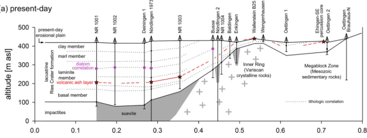
Figure 5. Schematic section through the Ries impact basin, with drilling locations arranged according to distance from crater center. (a) Present-day situation.
(b) Numerical sediment decompaction. (c) Initial situation at the time of the volcanic ash deposition.
Figure 6. Geological map of the Ries impact crater fill showing the concentric outcrop of major lithofacies units and reconstruction of the evolution of the crater fill geometry. Miocene sediment thickness contour lines according to Ernstson (1974), with modifications according to drill data. tr, Triassic; j, Jurassic; bb, Bunte Breccia. (i) Initial situation at the time of the volcanic ash deposition. (ii) Situation at the end of the Miocene when the crater basin was completely filled. (iii) Present-day situation after Plio- to Pleistocene erosion of about 100 m sediment. General structure of the Ries basin modified from Pohl et al. (1977).
ter interior that can lead to vertical modification of the crater floor elevation (e.g., sagging, subsidence, and uplift). In the very short-term modification-stage of the cratering event, the transient crater cavity undergoes collapse; in smaller craters, rim crest/crater wall landsliding and floor uplift occur, and in larger craters, listric faulting, wall terracing, central peak formation, and general crater floor uplift and flattening are seen (see, e.g., Kenkmann et al., 2013). Additional contributions to crater floor shallowing include impact ejecta fallback and flow of impact melt down the crater wall and terraces, ponding on the crater floor (Hawke & Head, 1977; Melosh, 1989). Following this initial rapid modification stage of the cratering event itself, there are five types of processes that can cause additional changes in crater floor elevation.
1) Thermal contraction processes: Heat is imparted to the crater interior through the transfer of the ki- netic energy of the impactor to the materials of the substrate, causing an array of effects ranging from mineral deformation to bulk impact melting. The magnitude of these processes scale with the velocity and mass of the projectile. Basin-scale impacts on the Moon such as ∼930-km-diameter Orientale basin are characterized by huge, kilometers-deep impact melt seas in basin interiors. There the cool- ing and solidification can involve ∼10% contraction, and extend for many hundreds of thousands of years, and cause many hundreds of meters of floor subsidence (e.g., Vaughan & Head, 2014; Vaughan et al., 2013).
The relatively small size of the Ries crater and the dispersal of impact melted material in the suevite deposit, suggest that subsidence due to thermal contraction of impact melt is negligible. A second source of thermal contraction is the conductive and radiative cooling of heat a) broadly distributed in the shocked and ejected material, and b) brought to the near-surface environment by the uplifting of deeper geotherms by the re- moval of cooler, near-surface material from the cavity and collapse of the transient cavity during the rapid modification stage. The magnitudes of these processes are scale- and substrate-dependent. For basin-scale events such as the Orientale Basin, these effects can contribute to thermal contraction and minor changes in basin topography lasting several tens of millions of years (e.g., Bratt, Solomon, & Head, 1985; Bratt, Solo- mon, Head, & Thurber 1985). The relatively small size of the Ries crater and the shallower geothermal gra- dient of the cooler continental lithosphere target substrate indicate that these processes produced negligible changes in floor topography.
2) Viscous relaxation processes: Lateral variations in geothermal gradient and lithospheric thickness, and temporal variations related to planetary thermal evolution, have been shown to be important in the evolution of impact basin topography on the Moon due to viscous relaxation processes over millions of years (e.g., Solomon et al., 1982). The small size of the Ries and the continental thermal structure of its substrate indicate that viscous relaxation processes were negligible.
3) Closure of impact-induced fractures, faults, and mega-porosity induced by dilatancy: During an impact event, the radial shock and attendant rarefaction waves cause significant downward and outward movement and displacement of the substrate, major shear deformation, and injection of impact melt and breccia dikes into the basement rock. Broadly referred to as dilatancy (inelastic volume increase due to intense deformation), such processes result in the near-instantaneous increase of the porosity of the autochthonous mega-breccias in the substrate below the crater interior and in the allochtho- nous breccia lenses deposited on the crater floor. Numerical simulations of impact-induced dilatan- cy point to significant subcrater porosities, decreasing with depth from more than 16% to less than 0.1% depending on crater size, structure, and hard rock quality (Collins, 2014). For example, Gohn et al. (2008) noted changes in post-impact marine sediment accommodation due to differential com- paction of impact-generated materials in Chesapeake impact structure. Recent high-resolution lunar gravity data have further demonstrated its importance for the Moon (e.g., Soderblom et al., 2015).
Although also scale-dependent, production of substrate porosity by impact-induced dilatancy, and its subsequent loss, is likely to be an important part of the topographic evolution of all crater interiors, including the Ries.
4) Longer-term geologic modification processes: Impact crater landforms are produced instantaneously in geologic time, are out-of-equilibrium with the ambient environment, and undergo modification by a range of geologic processes that influence the topography of the basin interior. On the Moon, magmatic processes involve volcanic flooding of crater interiors, (e.g., Whitten & Head, 2013) and intrusion of sills in the breccia lens below the crater floor causing uplift (e.g. Jozwiak, et al., 2015; Wilson & Head, 2018),
both processes resulting in crater floor shallowing. Explosive volcanic eruptions on Mars are known to produce widely dispersed tephra (e.g., Kerber et al., 2012) and potentially significant deposits on crater floors (e.g., Le Deit et al., 2013). With the exception of the deposition of the dis- tal ash layer, magmatic processes are not known to have influenced the evolution of the Ries crater.
Sedimentary infilling processes, however, have been significant in shal- lowing of the Ries crater floor. Numerous studies have demonstrated the role of fluvial, lacustrine and biological processes in the production, transport and deposition of sediment onto the crater floor. Conglomer- ates and stream deposits at the basin margins testify to the role of fluvial processes operating to modify the crater rim and walls, and to trans- port suspended sediment to the basin interior. Lacustrine deposits and sedimentary facies in the crater interior demonstrate that shallowing took place by infilling with lake sediments, aided by groundwater-re- lated tufa deposition and local algal bioherm growth. No evidence for extensive eolian deposition (e.g., subaerial cross-bedding, etc.) has been documented. Thus, fluvial and lacustrine sedimentary infilling appear to be the dominant processes in crater floor shallowing of the Ries.
5) Loading, flexure, compaction, and floor subsidence: A potentially im- portant factor in crater floor subsidence is the loading of the crater interior and the changes in topography induced by these loads and their effects. At very large impact basin scales, loading of the basin interior by dense volcanic lavas has been shown to induce flexure and significant subsidence in lunar basins (e.g., Solomon & Head, 1980), a factor that appears negligible at smaller crater scales.
In the case of the Ries crater, sediments deposited in the lacustrine en- vironment will undergo internal volume changes related to compaction, dewatering and diagenesis, factors discussed in Section 5.1 (Data Set S3).
Indeed, sediment load causing compaction is known to modify impact craters (Gohn et al., 2008; Tsikalas & Faleide, 2007; Tsikalas et al., 1998).
In addition, the combination of the increasing sediment load and the oscillating water load (changes in depth with time) can exert pressure on the deeper substrate below the crater floor, and contribute to the closing of the dilatancy-induced mega-porosity in the underlying brecciated substrate.
In summary, of the range of processes operating to alter the interior topography of impact craters, the three most likely to be operating in the Ries crater are: 1) crater lake sedimentary infilling to reduce the depth of the floor, 2) dewatering and diagenesis of these lake sediments to increase the depth of the floor and 3) compaction of the dilatancy-induced mega-porosity in the breccia lens below the crater floor, to increase the depth of the floor. The deposition of the volcanic ash layer provides the opportunity to assess the magnitude and temporal relationships of these processes.
While a major part of the sagging in the Ries structure is to be assumed for the more than 4 km deep im- pact brecciated crystalline basement, crater floor sagging should also be evident by a convex surface of the 300 m thick suevite, which itself largely retained its high initial porosity (Förstner et al., 1967: 28%; Stöffler et al., 2013: 25%–30%; Popov et al., 2014: high-temperature suevite 27.9 ± 3.7%, and low-temperature suevite 21.4 ± 4.2%) due to its early lithification. Indeed, the few drillings available at the central crater inner slope are consistent with a convex shape of the suvite layer, although more drill cores are required for a final proof. As a consequence of the bowl-shaped crater fill geometry, Plio-Pleistocene exhumation and erosion lead to a circular outcrop pattern of the subsided lithostratigraphic units of the Ries impact crater fill, with bituminous shales and laminites at the margin, massive marlstones following farther inside, and a central area with lignite-bearing clays (Figure 6).
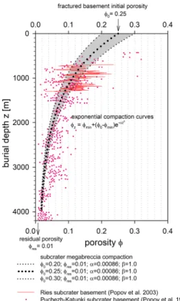
Figure 7. Model compaction curves of the subcrater crystalline rock breccias to demonstrate the plausibility of 134 +23/−49 m crater floor subsidence in the Ries impact structure.
5.4. Estimation of Ries Subcrater Compaction
On the basis of the available data described here, our reconstruction indicates that the 134 +23/−49 m floor subsidence unaccounted for by lake sediment compaction is most plausibly attributable to early sed- iment-water loading and closure of sub-crater floor macro-porosity initially induced by impact-generated dilatancy. The exact initial geometry of the subcrater dilatant zone is unknown, but on the basis of the inferred geometry of the transient cavity, Stöffler et al. (2013) estimated a depth of ∼4 km for impact-in- duced fractures.
Unlike on the Moon, impact structures on Earth generally show a negative Bouguer gravity anomaly and reduced seismic velocities of the target basement, indicating an increased porosity relative to the unaf- fected surroundings (Milbury et al., 2015; Pilkington & Grieve, 1992). This also applies to the Ries impact structure, with a present negative Bouguer gravity anomaly (0–18 mgal in the crater interior: Kahle, 1969;
Pohl et al., 1977) reflecting both the lower density sedimentary fill and residual porosity in the sub-crater brecciated rocks.
Initial porosities of subcrater megabreccias (i.e., porosities shortly after an impact event) are, to our knowledge, unknown. Polymict crystalline rock breccias of the inner ring of the Ries, which underwent lateral transport and retained their initial porosities due to early carbonate cementation, show macropo- rosities of up to 30% (Data Set S4). While this value is probably higher than for monomictic breccias and fractured blocks of the subcrater, it may represent an upper limit for initial porosity estimates ϕ0. Direct measurements of present-day subcrater porosities, in turn, are known from few deep drilling sites, specif- ically at the Puchezh-Katunki, the Chesapeake, and the Ries (Popov et al., 1998, 2003, 2014). Further data are available for example, from the peak ring of the Chicxulub crater, whose fractured granitoids, how- ever, were subject to lateral transport (Christeson et al., 2018; Elbra & Pesonen, 2011; Rae et al., 2019).
For the Ries impact structure, the 600 m cored subcrater lithologies consist of crystalline rocks (gneiss and granites, with additional amphibolites in upper part) with intercalated breccia dikes show highly variable porosities (0.0%–37.9%; Popov et al., 2003: their Table 3), even within the same target lithology. However, most core intervals show porosities ranging between ca. 5% and 18% (Popov et al., 2003: their Figure 11), providing a rough calibration for the 700–1300 m depth interval (i.e. 100 m eroded sediment added) of a subcrater compaction curve (Figure 7). For greater depth, porosity information of impact affected crystal- line basement rocks is available from the 5,374 m deep borehole Vorotilovo of the Puchezh-Katunki impact structure: Porosities decrease from about 10%–20% at 600 m depth, to 5%–10% at 2,000 m depth, and finally about 2%–4% at 5,000 m depth (Popov et al., 1998, 2014). This 80-km-sized impact structure, however, is larger than the Ries, with brecciation and fracturing ranging deeper into the target basement rocks. We therefore assume low porosities of 2%–4% already at 2.5–3.5 km depth for the Ries subcrater rocks.
Based on these assumptions, a decompaction with an initial porosity ϕ0 of 25% at z = 0 m, ϕz = 11% for z = 1,000 m, and ϕz = 3% for z = 3,000 m, would be consistent with 153 m long-term crater floor sagging (+37/−34 m for ϕ0 = 20%–30%) (Figure 7; Data Set S4). While these calculations are preliminary and vary dependent on the assumptions made, they demonstrate that a mechanical compaction of brecciated sub- crater crystalline rocks is in the range of the inferred 134 +23/−59 m crater floor subsidence. In any case, a further investigation of subcrater porosity evolution and potential other mechanisms of crater floor subsid- ence is required. Likewise, the microporosity of impact-affected rocks (e.g., Huber et al., 2021) is not taken into account in the present considerations.
5.5. Implications for Craters on Earth and Other Planetary Bodies
Clearly, initial dilatancy-related sub-crater porosity will vary as a function of a wide range of factors: impact event scale, substrate composition and structure, angle of impact, planetary gravity, presence nature and ambient state of an atmosphere and hydrosphere (e.g., Collins, 2014). Detailed documentation of the timing and likely origins of crater subsidence in the Ries crater provide a baseline for comparison to other craters on Earth and other planetary bodies.
For other craters on Earth, the relationship between crater interior subsidence and the application of loads from lake water and sediments should be assessed in detail. Does subsidence require the application of
these loads, or are there examples of significant subsidence occurring prior to lake formation and sedi- mentary infilling? On the Earth's Moon, low gravity and overburden pressure favor development of more significant dilatancy-related porosity and the lack of an atmosphere and hydrosphere precludes loading by lake water and lacustrine sediments; thus, the Moon is an excellent laboratory for the exploration of the variable parameter space in dilatancy-related porosity formation (e.g., Soderblom et al., 2015) and its long- term behavior. On Venus, crater floor subsidence has only been described for bright-floored (volcanism-free, lacking sedimentary infill) large impact craters, where a subsidence of 100–300 m is interpreted to reflect thermal subsidence of an insufficiently rigid, thin lithosphere (Brown & Grimm, 1996).
Mars, on the other hand, retains abundant impact craters, and was characterized early in its history by a thicker atmosphere and evidence for pluvial, fluvial and lacustrine activity and environments. An increas- ing number of Martian craters are known to contain sedimentary deposits (e.g., Eberswalde, Gale, Holden, Jezero: Ehlmann et al., 2008; Malin & Edgett, 2000; Schon et al., 2012; Tikhonravov, Antoniadi, Cassini:
Fassett & Head, 2008a). Specifically, more than 400 open and closed crater lake basins of the Noachian and Hesperian era contain post-impact sediments of deltaic or lacustrine origin (Goudge et al., 2016), when Mars was at least intermittently warm and wet (Carr & Head, 2010a, 2010b). In addition, a number of ar- eas in the northern lowlands (e.g., Utopia Planitia) show evidence of circular deformation and subsidence features that have been interpreted to represent impact craters that have been filled with sediment that underwent compaction and caused some related faulting (e.g., Buczkowski & Cooke, 2004; Buczkowski &
McGill, 2002; Buczkowski et al., 2005; McGill & Hills, 1992).
There are currently no examples known of Martian craters that unequivocally show lacustrine strata in- clined to the crater center. Rather, the evident and likely sedimentary crater fills are flat lying or inclined in various directions reflecting foreset beds (e.g., Terby: Ansan et al., 2011; Wilson et al., 2007) or possibly eolian, anticompensational deposition (Kite et al., 2016). At central mound in Gale Crater, strata dip gently (1.7°–4.5°) away from the central peak (Kite et al., 2013, 2016) toward a ring moat, explained by compaction due to later sediment load (Grotzinger et al., 2015). However, the low density of the sediments exposed at the current erosional crater bottom suggest that the 5 km deep crater was never filled completely with sediments, with a maximum sediment overburden of less than 1800 m (+600/−500 m) (Lewis et al., 2019).
Likewise, modeling demonstrates that the observed sediment layer orientations in Gale could only be ex- plained by a > 3 km thick donut-shaped past overburden, whose formation appears difficult to explain by known sedimentary processes (Gabasova & Kite, 2018). In any case, wherever clear concentric outcrop pattern of layered deposits in Martian craters were observed (e.g. unnamed crater within Schiaparelli ba- sin: PSP_005897_1790; Beyer et al., 2012; unnamed crater in West Arabia Terra: MOC M14-01647; Malin
& Edgett, 2000; Crommelin Crater: Lewis et al., 2008), these layered deposits are rather regional deposits (possibly duststones) draping over various, partially eroded craters (Grotzinger & Milliken, 2012; Lewis et al., 2008). On the other hand, Buczkowski and Cooke (2004) and Buczkowski et al. (2005) mapped circu- lar graben in Utopia Planitia, and concluded that graben spacing supported the fill and compaction of wet sediment of up to 1–2 km thickness (assuming that the underlying basement was rigid and that all the com- paction was in the sediment infill). In a more recent analysis, Gabasova and Kite (2018) updated approaches to the analyses of sediment compaction, but also assumed that the basement underwent no compaction.
Unfortunately, details of the subsurface sediment bed orientation, the presence of any temporal marker beds, and the duration of the modification process are unknown for most of these studies.
The apparent absence of crater floor sagging of exposed beds on Mars may reflect either a lack of obser- vations, or the possibility that many Martian impacts might have occurred during cold and dry phases (no rainfall, fluvial erosion or lacustrine environments), no significant groundwater influx, and volatile-rich but frozen icy regolith). In this case, flooding and sedimentation occur a significant time after crater forma- tion, perhaps during intermittent wet phases. Such a scenario might be consistent with the proposed short intermittent formation time of deltaic systems in Martian crater basins (de Villiers et al., 2013). For Gale crater, the inclination of present-day surface beds may not necessarily reflect compaction of hidden strata beneath (with an estimated thickness of 1–2 km; Grotzinger et al., 2015), but may partially result from sagging in the impact-fractured subsurface. On the other hand, Buczkowski et al. (2005) and Gabasova and Kite (2018) have shown evidence for sediment filled craters that have undergone differential compaction, under the assumption that the sub-sediment basement was rigid and non-porous. On the basis of the Ries
crater example documented here, future analysis and exploration should investigate the temporal relation- ships between initial crater formation and the role of subsequent flooding and water-sediment flooding on crater floor subsidence.
6. Conclusions
(i) The clinoptilolite-heulandite-buddingtonite bed in the lacustrine succession of Ries impact crater is a distal volcanic ash of the contemporaneous, intensive volcanism in the Pannonian Basin, 760 km east of the Ries
(ii) This volcanic ash bed can be traced from surface outcrops at the basin margin to 220 m depth within the basin center, thereby demonstrating a deeply bowl-shaped geometry and concentric outcrop pat- tern of the sedimentary crater fill
(iii) The compaction of sedimentary units alone is insufficient to explain this geometry which we thus attribute to water-sediment loading and closure of dilatancy-induced mega-porosity in the underlying breccia lens
(iv) These results have important implications for understanding the nature and history of impact craters on the Earth and other planetary bodies, particularly Mars
Data Availability Statement
All data used in this publication are available in Arp et al. (2021) on the Göttingen Research Online Data repository.
References
Ansan, V., Loizeau, D., Mangold, N., Le Mouélic, S., Carter, J., Poulet, F., et al. (2011). Stratigraphy, mineralogy, and origin of layered de- posits inside Terby crater, Mars. Icarus, 211(1), 273–304. https://doi.org/10.1016/j.icarus.2010.09.011
Arp, G., Bissett, A., Brinkmann, N., Cousin, S., de Beer, D., Friedl, T., et al. (2010). Tufa-forming biofilms of German karstwater streams:
Microorganisms, exopolymers, hydrochemistry, and calcification. Geological Society, London, Special Publications. 336, 83–118. https://
doi.org/10.1144/SP336.6
Arp, G., Blumenberg, M., Hansen, B. T., Jung, D., Kolepka, C., Lenz, O., et al. (2013). Chemical and ecological evolution of the Miocene Ries impact crater lake, Germany: A reinterpretation based on the Enkingen (SUBO 18) drill core. The Geological Society of America Bulletin, 125(7–8), 1125–1145. https://doi.org/10.1130/B30731.1
Arp, G., Dunkl, I., Jung, D., Karius, V., Lukács, R., Zeng, L. et al (2021). Data and Supporting Information for publication 'A volcanic ash layer in the Nördlinger Ries impact structure (Miocene, Germany): Indication of crater fill geometry and origins of long-term crater floor sagging'. Göttingen Research Online Data. https://doi.org/10.25625/DRPFR9
Arp, G., Hofmann, J., & Reitner, J. (1998). Microbial fabric formation in spring mounds ("microbialites") of alkaline salt lakes in the Badain Jaran sand sea, PR China. Palaios, 13(6), 581–592. https://doi.org/10.2307/3515349
Artemieva, N. A., Wünnemann, K., Krien, F., Reimold, W. U., & Stöffler, D. (2013). Ries crater and suevite revisited—Observations and modeling Part II: Modeling. Meteorit Planetary Science, 48(4), 590–627. https://doi.org/10.1111/maps.12085
Athy, L. F. (1930). Density, porosity, and compaction of sedimentary rocks. American Association of Petroleum Geologists Bulletin, 14(1), 1–24.
Barakat, A. O., & Rullkötter, J. (1997). A comparative study of molecular paleosalinity indicators: Chromans, tocopherols and C20 isopre- noid thiophenes in Miocene lake sediments (Nördlinger Ries, Southern Germany). Aquatic Geochemistry, 3(2), 169–190. https://doi.
org/10.1023/A:1009645510876
Beard, D. C., & Weyl, P. K. (1973). Influence of texture on porosity and permeability of unconsolidated sand. American Association of Petroleum Geologists Bulletin, 57, 349–369. https://doi.org/10.1306/819A4272-16C5-11D7-8645000102C1865D
Beyer, R. R., Stack, K. M., Griffes, J. L., Milliken, R. E., Herkenhoff, K. E., Byrne, S., et al. (2012). An atlas of mars sedimentary rocks as seen by HIRISE. In J. P. Grotzinger, & R. E. Milliken (Eds.), Sedimentary geology of Mars. SEPM special publication (Vol. 102, pp. 49–95).
Tulsa, OK: SEPM.
Bolten, R., Gall, H., & Jung, W. (1976). Die obermiozäne (sarmatische) Fossil-Lagerstätte Wemding im Nördlinger Ries (Bayern). Ein Be- itrag zur Charakterisierung des Riessee-Biotops. Geologische Blätter für Nordost-Bayern, 26, 75–94.
Bratt, S. R., Solomon, S. C., & Head, J. W. (1985). The evolution of impact basins: Cooling, subsidence, and thermal stress. Journal of Geo- physical Research, 90, 12415–12433. https://doi.org/10.1029/jb090ib14p12415
Bratt, S. R., Solomon, S. C., Head, J. W., & Thurber, C. H. (1985). The deep structure of lunar basins: Implications for basin formation and modification. Journal of Geophysical Research, 90, 3049–3064. https://doi.org/10.1029/jb090ib04p03049
Brown, C. D., & Grimm, R. E. (1996). Floor subsidence and rebound of large Venus craters. Journal of Geophysical Research, 101(E11), 26057–26067. https://doi.org/10.1029/96JE02706
Buczkowski, D. L., & Cooke, M. L. (2004). Formation of double-ring circular grabens due to volumetric compaction over buried impact craters: Implications for thickness and nature of cover material in Utopia Planitia, Mars. Journal of Geophysical Research, 109(E2), E02006. https://doi.org/10.1029/2003JE002144
Acknowledgments
The authors acknowledge †Michael Wolff who first mentioned the clinop- tilolite bed in the Ries impact structure and provided a corresponding sample (Ehingen locality) for the present study.
The authors are indebted to Exxon Mobil Production Deutschland GmbH for access to drillings NR 1001–1004, sampling permit, and permission for publication of data. Karin Heck, Ries Crater Museum, supported sampling and documentation in the drill core facilities. The study benefited from a number of drill core and outcrop samples provided by Terrasond GmbH Günzburg, Geotechnik Augsburg Ingenieurgesellschaft mbH, Oliver Sachs, Kurt Kroepelin, Ralf Barfeld and Gisela Pösges. Percussion drill coring was carried out by Steffen Stark, LfU Hof. XRF analyses were performed by Gerald Hartmann. The authors thank Andreas Murr and Gerhard Doppler for NAFB bentonite reference samples. The authors are grateful to Joanna Morgan, Richard Grieve, and Fred Horz for in- formation on impactite porosities. This work was funded by German Research Foundation, grant DFG AR335/9-1.
L. Zeng thanks the China Scholarship Council (CSC) for his financial support.
R. Lukács is funded by the Bolyai J. Re- search Fellowship. The authors thank M. H. Poelchau and an anonymous reviewer for their detailed, constructive, and very helpful comments and sug- gestions that significantly improved the manuscript. Finally, we acknowledge support by the Open Access Publication Funds of the Georg-August-University Göttingen. Open access funding ena- bled and organized by Projekt DEAL.