UNIVERSITY OF SZEGED PHD SCHOOL OF EARTH SCIENCE
Theses of Ph.D Dissertation
Evaluation of anthropogenic effects impacting river systems through environmental investigation of oxbow lakes near
Lower-Tisza and Hármas-Körös
MARGIT TAMÁS
Supervisor:
Dr. Andrea Farsang, DSc Associate professor
Department of Physical Geography and Geoinformatics Szeged
2018.
2
3
1. Antecedent and aims
As a consequence of the water regulation activities of Tisza and its side rivers in the second half of 19th century, floodplains have been formed, that are being used for arable farming, forestry and grassland. Significant amount of our nature reserves are located at the floodplain of our rivers (Dobrosi et al., 1993). In the floodplain as well as outside the dyke there are several smaller – bigger size oxbow lakes. Next to Lower-Tisza there are 11 oxbow lakes with an area of more than 560 hectares. Next to Hármas-Körös there are 19 oxbow lakes with an area of around 730 hectares.
Primary aim of my research is to classify the status of the floodplains through the examination of the water quality, contamination of the soil of floodplain, the sludge of oxbow lakes in Lower-Tisza and Hármas-Körös. Beside of this my aim is – after identifying the accumulating contaminants in the sediment of the oxbow lakes – to examine the source of the contaminants in the sludge, and then according to an international method to evaluate the ecological risk of oxbow lakes based on the quality of their sediment.
In my doctoral research I’ve defined the below aims in regards of the water-soil-sludge system of the floodplain:
evaluation of oxbow lakes in Lower-Tisza through water quality indicators (ammonium, nitrate, nitrite, chemical oxygen demand and toxic micro polluters) between 1988 and 2005;
exploration of the differences of land use in Lower-Tisza and Hármas-Körös based on the contamination-content (Cu, Ni, Co, Cr, Pb, Zn, Cd, As) of the soils in the different land of usage of the floodplain;
definition of the accumulating contaminant-content in the riverbed of the floodplain with contamination index calculation (Pb, Cd, Zn, Cu, Ni) in favor of the contamination level of the oxbows could be compared;
definition of the differences of floodplain and out of dyke oxbows as well as oxbows near Tisza and Körös, in order to let different actions to be defined for recreation;
comparison of the quality of water and sediment at Upper- and Lower-Tisza considering if the location is floodplain or outside the dyke;
definition of the accumulation of the contaminating material settled out in floodplain, especially concentrating on the separation of natural and anthropogenic polluters;
marking those polluters, heavy metals, that’s mobility is high or extremely high, though they need intensified attention;
4
selecting the method that can be used for the ecological risk assessment of oxbow lakes, application of the selected Hakanson ecological risk model;
definition of sequence of the oxbow lakes from highest ecological risk to the lowest in favor of identifying the oxbow lakes that need urgent action;
definition of the most critical polluters in order to facilitate the rehabilitation of the oxbow lakes.
I’ve evaluated the available water, soil and sludge data based on the limit value defined in the applicable laws.
5
2. Materials and methods
The sample areas in Lower-Tisza and Hármas-Körös were ideal for my research because of several reasons. At first it was expedient as the sample areas are sufficiently diverse, considering its degree of protection, utilization, usage of area and location of the oxbows.
Secondly as there was / is similar research in Upper-Tisza the results of the two researched can be compared.
For the evaluation of oxbow lakes in Lower-Tisza I’ve used the water quality data (ammonium, nitrate, nitrite, chemical oxygen demand and toxic micro polluters) that was provided by the laboratory of Inspectorate of Environment and Environmental Protection Agency of Lower-Tisza, in regards of Serházzugi, Nagyfai, Mártélyi and Körtvélyesi oxbows.
The data was collected between 1988 and 2005.
I made the soil sample collections near two oxbow lakes in 2010. One was the Osztorai Holt-Tisza, where I’ve collected soil samples from 3 different land use (meadow, forest, plow).
While in the other case I’ve made the inspection of pasture and forest soil at Brenazugi Holt- Körös.
Considering sludge quality I’ve analyzed 15 oxbow lakes (near Hármas-Körös the Brenazugi, Malomzugi, Iriszlói, Csengedi-outside the dyke, Csengedi-floodplain,, Fűzfászugi, Endrőd-Középső, Hantoskerti, near Lower-Tisza the Csongrádi, Osztorai, Mártélyi, Körtvélyesi, Nagyfai, Atkai and Sasér). Some part of the analyses came from previous condition surveys (Farsang A., 2003a, 2003b, 2004, 2006), while other parts came from own sample collection and laboratory examination (2006, 2007, 2011).
On my soil and sludge samples – after drying and pulverizing – I’ve performed the below analyses:
pH (H2O, KCl) – Radelkis-type pH measure, based on MSZ-08-0206/2:1978 standard;
lime content inspection – with Scheibler calcimeter based on MSZ-08-0206/2:1978 standard;
organic material inspection – after the destruction with potassium dichromate and sulfuric acid I’ve inspected the opacity with UNICAM Helios Gamma UV-VIS (Thermo Scientific) spectrophotometer;
humus quality inspection – definition with NaF and NaOH solution based on MSZ 21470/52:1983 standard;
total nitrogen-content measure with Gerhardt Vapodest 20 nitrogen distiller based on MSZ- 080458-80 standard;
definition of heavy metal concentration after aqua regia exploration with Perkin Elmer 3110 type equipment based on MSZ-21470/50:2006 standard;
6
sequential extraction with BCR technology (acid soluble phase, namely fraction of replaceable metals and fractions bound to carbonates; reducible phase, namely the fraction bound to iron- and magnesium oxides; oxidable phase, namely the fraction bound to organic materials and to sulphides, as well as residual phase, namely fraction bound to minerals).
During the classification of the water quality of the oxbows I’ve evaluated based on the limit values defined in MSZ 12749:1993 standard, guidelines of decree 31/2004. (XII.30.) and the decree 10/2010. (VIII.18.) that was released by the Ministry of Water Resources and defines the rules of usage and pollution limit values of top water.
I’ve graded the concentration of contaminating material during the soil- and sediment investigation based on the “B” limit value of pollution defined in the decree 6/2009. (IV. 14.) KvVM-EüM-FVM, that defines the limit values and the measure of pollutions for the protection of geological medium and underground water pollution. I’ve also used the (non-applicable) decree 10/2000. (VI.2.) KöM-EüM-KHVM limit values of quality protection of underground water and geological medium, that’s “A” background concentration values define the natural or nature concentration of material in the soil.
The 40/2008. (II.26.) government regulation contains the permissible concentration of poisonous and harmful materials in soils. Using the limit values defined in the above regulation let us measure the possibilities of placing the rummaged-out sludge during the recultivation of oxbows to agricultural locations.
For the summarization and evaluation of the measured values I used Microsoft Excel 2010 and PAST 3.1 application.
7
3. Summary of results, theses
3.1 I’ve evinced that except nitrate the waters of outside the dyke oxbows at Lower- Tisza have higher nutrition content (ammonium, nitrite, chemical oxygen demand) than water of floodplain oxbows.
My above statement is based on the procession of water quality data (ammonium, nitrate, nitrite, chemical oxygen demand) of oxbow lakes at Lower-Tisza between years 1988 and 2005. My result concurs with the result of researches at Upper-Tisza (Szabó-Babka, 2007).
1. chart. Average and dispersion values of nutrition-content in the water of oxbow lakes Examined
element
Outside the dyke oxbow lakes Floodplain oxbow lakes 10/2010. VM regulation limit value
Serházzug Nagyfa Mártély Körtvélyes
NH4+
(mg/l)
0,30 ± 0,35 (n=109)
0,85 ± 1,58 (n= 102)
0,16 ± 0,16 (n=111)
0,20 ± 0,31
(n=106) < 0,3 NO2-
(mg/l)
0,08 ± 0,11 (n=102)
0,09 ± 0,17 (n=97)
0,03 ± 0,04 (n=105)
0,04 ± 0,07
(n=96) No data
NO3-
(mg/l)
0,87 ± 1,29 (n=105)
0,92 ± 1,07 (n=99)
1,00 ± 1,45 (n=109)
1,41 ± 2,33
(n=98) < 0,4 CODp
(mg/l)
13,11 ± 2,63 (n=102)
38,27 ± 24,35 (n=97)
7,65 ± 2,82 (n=105)
10,67 ± 3,85
(n=96) < 40
Based on the limit values defined in 10/2010. Government regulation I’ve evaluated the average ammonium, nitrate, nitrite and chemical oxygen demand values of two floodplain (Mártély and Körtvélyes) and two outside the dyke (Serházzug and Atka) oxbow lakes between 1988 and 2005. Considering the 17 years period’s average both nitrate and nitrite content of Nagyfai oxbow exceeded the limit value, and the nitrate- content of all four oxbows was above limit value.
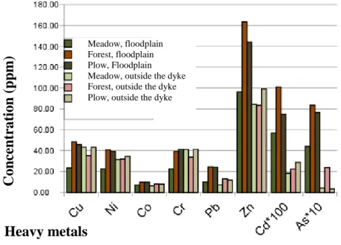
3.2 Both in the soil of Tisza and Körös Pb, Zn, Cd and As elements – independently to the type of area-usage – are present in higher concentration in the floodplain than in the soil of outside the dyke.
At my sample areas I’ve explored contamination-content of the floodplain soils of the different use of area, as well as the differences based on the use of area:
▪ Soils in floodplain of Körös don’t show pH, lime content, quantity and quality of hummus neither metal concentration differences in regards of usage of area (meadow and forest).
▪ No laws can be concluded based on the investigation of pH, lime content, quantity and quality of hummus regarding the usage of are in the floodplain at
8 Lower-Tisza. It can be concluded that in regards the average contamination- content, all investigated element shows lower values at meadow parcels than forest or plow.
▪ For the investigated soil parameters there’s no laws of difference or similarity nor in regards of usage of area at Tisza or Körös, neither in relation to areas in floodplain or outside the dyke (1. figure). Concentration of Pb, Zn, Cd and As elements are higher in the floodplain than outside the dyke in soils of both Tisza and Körös.
1. figure. Results of the metal investigation of soils of Tisza
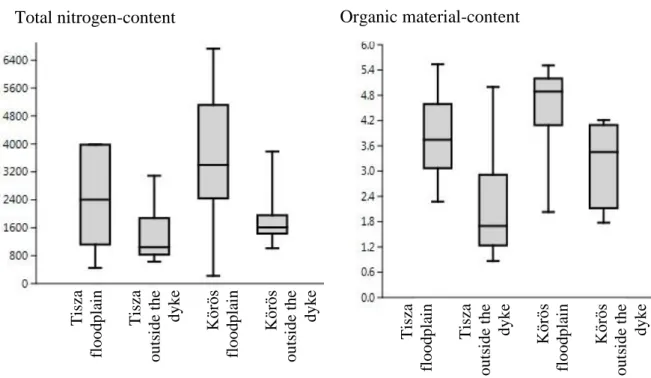
3.3 I’ve concluded that regarding the total nitrogen-content and the organic material-content, sediment of oxbows at Körös have higher nitrogen- and organic material-content than the ones at Tisza. This applies in regards of floodplain and outside the dyke too.
I’ve investigated the total nitrogen-content and organic material-content of sludge from six oxbows at Lower-Tisza and eight oxbows at Körös. I’ve concluded that the total nitrogen-content and organic material-content of floodplain oxbows are higher than outside the dyke oxbows. Floodplain of oxbows at Körös have higher total nitrogen-content than the ones at Tisza, over and above the outside the dyke oxbows at Körös have higher organic material-content percentile than outside the dyke oxbows at Tisza (2. figure). In total it can be concluded that based on total nitrogen- and organic material-content the oxbows can be sorted in the following decreasing
Meadow, floodplain Forest, floodplain Plow, Floodplain Meadow, outside the dyke Forest, outside the dyke Plow, outside the dyke
Heavy metals
C o ncentr a ti o n (pp m )
9 sequence: Körös (floodplain) > Tisza (floodplain) > Körös (outside the dyke) > Tisza (outside the dyke).
.
2. figure. Comparison of total nitrogen-content and organic material-content of floodplain and outside the dyke oxbows at Tisza and Körös
3.4 I’ve concluded that regarding all contaminants the sediment of oxbows at Tisza have higher element-content than the ones at Körös. This is true in regards of floodplain and outside the dyke as well.
After the evaluation of surface water and soil results, the analytical inspection followed, then this was evaluated from several aspects (evaluation in regards limit value, contamination index, comparison of floodplain and outside the dyke, marking the mobile contaminant materials).
While comparing the average element content of the oxbows at Körös to the “B” limit value defined in 6/2009. (IV.14.) regulation, I’ve concluded that except one oxbow (Csengedi, outside the dyke) the nickel-content of the sediment exceeds the limit value. The average nickel and chromium content of all floodplain at Körös exceeds the limit value define in the regulation. At floodplains if Lower-Tisza I’ve experienced that several metal-content (Cd, Cu, Ni, Zn and Cr) exceeds the “B”
contamination limit value. While investigating the outside the dyke oxbows at Tisza the limit values also exceeded in regards Cd, Ni and Zn elements.
The sediment-inspection of the oxbows both at Tisza and Körös confirmed that outside the dyke oxbow lakes are less contaminated than floodplains in regards of
Organic material-content Total nitrogen-content
Tisza- hullámtér Tisza- mentett o. Körös- hullámtér Körös- mentett o. Tisza- hullámtér Tisza- mentett o. Körös- hullámtér Körös- mentett o.
Tisza floodplain Tisza outside the dyke Körös floodplain Körös outside the dyke Tisza floodplain Tisza outside the dyke Körös floodplain Körös outside the dyke
10 contaminant metals. Beside of this it can be shown that in total the oxbow lakes at Körös are less contaminated than the ones at Tisza.
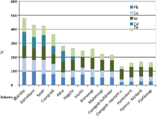
3.5 I’ve concluded that the contamination index can be used to define those elements that are the most dangerous from environmental perspective during re- cultivation of an oxbow lake, in the other hand it is also usable to define the relative contamination sequence of oxbow lakes.
The comparison of the 14 oxbows was based on the contamination index, that is the quotient of the maximum element concentration of the inspected oxbow and the maximum concentration of all oxbows (this is handled as 100%) (3. figure)
3. figure Contamination index of the sludge of outside the dyke at Lower-Tisza and Hármas-Körös
According to the calculations of the contamination index, the amount of cadmium in the sludge significantly impacts the contamination sequence, while zinc, copper and lead has lower impact.
The contamination index is applicable to define the relative contamination relation of the investigated oxbows. I’ve concluded that the most contaminated oxbows are floodplains at Tisza (these are Mártélyi-, Körtvélyesi-, Saséri-oxbows), than high contamination at outside the dyke at Tisza (Csongrád, Atkai, Nagyfa). That is followed by the floodplain oxbows at Körös (Brenazug, Iriszló, Malomzug, and
Oxbows
11 Csengedi-oxbow floodplain), then the lowest heavy metal contamination can be seen outside the dyke at Körös (Csengedi-oxbow outside the dyke, Hantoskerti, Gyoma- Középső and Fűzfászugi). Based on the contamination index the following contamination sequence can be defined: Körös (floodplain) > Körös (outside the dyke) > Tisza (floodplain) > Tisza (outside the dyke).
3.6 I’ve concluded that – based on total element content and the proportion of mobile fraction – in regards the oxbows at Lower-Tisza, considering both oxbow types the least mobile elements are Pb and Cr, while the most dangerous from environment perspective is Cd.
After identifying the most critical, most contaminated oxbows, I’ve performed the sequential extraction of those elements (As, Zn, Cd, Pb, Ni, Co, Mn, Cr, Cu) that needs intensified attention, due to their extremely high mobility. Namely I’ve inspected the fractional dispersion of the elements in seven oxbows at Tisza (Csongrádi-, Osztorai-, Mártélyi-, Körtvélyesi-, Nagyfai-, Atkai-, Saséri). Separating the elements measure in the sludge of the floodplain and outside the dyke oxbow lakes we defined a mobility order based on the proportion of total metal-content and mobilizable fraction. The mobility order of the sludge of floodplain oxbow lakes is the following: Pb<Cr<Ni<Co<As<Cu<Zn<Mn<Cd, while outside the dyke it is:
Pb<Cr<Cu<Co<Ni<Zn<As<Cd<Mn. Therefore, it can be concluded in both examined areas that the least mobilizable elements are Pb and Cr, while the “most critical” are Cd and Mn. While so regarding the total element content we should focus on Ni, Cr, Zn and Cd for the qualification of sludge of the oxbows, or while investigating the potential ecological impact, it can be seen that – present in firmly bound form – the critical elements are Ni and Cr.
So we have to consider the zinc and cadmium content of the sludge – as well as Mn and As, which is presented in firmly bound status under 30% in the sludge – when placing the sludge on agricultural field or the question is to define the ecological status of the oxbow.
3.7 I’ve adapted the Hackanson risk assessment procedure to local circumstances and I’ve concluded that all oxbows at Körös can be classified as moderate contaminated and low ecological risk classification. Outside the dyke oxbows at Tisza can be classified as moderate, while floodplain oxbows are classified as high. All oxbows at Tisza is classified as moderate ecological risk classification.
Based on this it can be concluded that the rehabilitation of floodplain oxbows should be preferred against outside the dyke water habitats.
12 The Hakanson risk assessment is a simple procedure that is applicable to qualify the metal concentration of the sludges only. This procedure let the contamination of the oxbows to be quantified and typified. The Hakasnon method evaluates the investigated area based on contamination degree and risk index. I made the calculations of five elements (Cd, Cu, Pb, Cr és Zn). Because there’s no defined average background-concentration value for the sediment I used the related “A”
background-concentration value defined in decree 10/2000. (VI.2.) KöM-EüM- FVM-KHVM. The floodplain and outside the dyke oxbows at Körös are classified as moderate contaminated and low ecological risk. Outside the dyke oxbows at Tisza are classified as moderate contaminated, while floodplains are highly contaminated.
All investigated oxbows at Tisza classified as moderate ecological risk. Considering the potential ecological risk index, it can be concluded that the primary focus should be on Mártélyi and Saséri oxbows then Körtvélyesi, afterwards Atkai oxbows should be considered. Only after this the rest of oxbows at Tisza and Körös should be rehabilitated. Because the potential ecological risk of floodplain oxbows is higher, than outside the dyke – also in case there are no further data available – the floodplain oxbow rehabilitation should be in favor of outside the dyke.
3.8 I’ve composed a suggestion and underpinned with calculations, that adjacent to the landfill of dredging sludge generated during the re-cultivation of oxbows, it is expedient to do the inspection and calculation of heavy metal mobile proportion – corrected with total nitrogen-content – when defining the size of the agricultural area.
Adjacent to the oxbow rehabilitation, the most important action is the removal of the accumulated sludge. It can be an obvious solution to landfill the excavated sludge onto agricultural areas. For this process I took into consideration the requirements defined in government decree 40/2008. (II.26.), decree 49/2001. (IV.3.) and decree 27/2006. (II.7.). Above laws define the maximum amount of elements can be landfilled on a hectare of agricultural area per annum. Considering the above I’ve investigated – regarding total nitrogen-content and contamination quantity of the sludge – that how many m3 of sludge can be landfilled onto 1 hectare of agricultural area depending on the limitation factors. If we investigate the total element content and total nitrogen-content, then it is the concentration of Co and Ni that defines the volume of landfillable sludge. For the cobalt-content of the sludge namely maximum
~100-160 m3 sludge can be landfilled onto agricultural area. In such case the full rehabilitation of Mártélyi oxbow would need more than 900 hectares for the sediment-landfill. Nevertheless, if the basis of the calculation is not the total element content, but the element proportion that can be accessed by the vegetation then the amount of sludge landfillable onto a hectare significantly increases. In this case the
13 total nitrogen-content becomes as the bottle neck. If the aim is to landfill the 95.000 m3 sludge of Mártély oxbow – while ~220 m3 can be landfilled onto a hectare – there’s a need for and are of around 420 hectares. If we would consider the mobile element proportion only, then the bottle neck would be the Co element in case of the investigated oxbows at Lower-Tisza. The only exception is the Atkai oxbow, where Cd is the element with highest mobility proportion, so being the limiting factor during landfill of sludge onto agricultural area.
While according to the total element-content investigation in the case of oxbows at Körös the most contaminated and critical elements are Ni and Cr, than at oxbows at Tisza these elements are Cd, Ni, Zn and Cr. However – according to the modelling calculations – because of the accessible element proportion of Co and Cr, the effect of placing these onto agricultural area is much more significant. The above statements confirm that – as in most cases the only option to keep the status of the water habitat is exaction of the sediment of the riverbed – to be able to do a cost-effective landfill of the excavated sludge, the complex ecological evaluation (namely the definition of oxbows with high ecological risk and the definition of contaminants) of the area to- be-rehabilitated is indispensable.
14
Publications:
1. Tamás, M. – Farsang, A. (2011a): Evaluation of environmental condition: water and sediment examination of oxbow lakes. ADG Landscape and Environment, 5, 2, 84-92.
2. Tamás, M. – Farsang, A. (2011): Nehézfém-szennyezettség vizsgálat Alsó-Tisza-vidéki hullámterületeken. In: Mócsy I., Szacsvai K., Urák I., Zsigmond A. R., Szikszai A. (szerk), VII. Kárpát-medencei Környezettudományi Konferencia, II. kötet. Sapientia Erdélyi Magyar Tudományegyetem, Kolozsvár, 634-642.
3. Tamás, M. – Farsang, A. – Vavra, Á. (2011): Az Alsó-Tisza vidéki és a Hármas-Körös völgyi holtágak környezeti állapot vizsgálata iszapminőségi mutatók alapján, Hidrológiai Közlöny, 91, 27-34.
4. Tamás, M. – Farsang, A. (2012): Alsó-Tisza-vidéki és Hármas-Körös menti holtágak környezeti szempontú értékelése iszapvizsgálatok eredményei alapján, Tájökológiai Lapok 10 (2) 231-245.
5. Tamás, M. – Farsang, A. (2012): Folyóvízi rendszerekre gyakorolt antropogén hatások feltárása holtágak üledékvizsgálatán keresztül. Lóczy D. (szerk), Geográfia a Kultúra Fővárosában I.: az V. magyar Földrajzi Konferencia természetföldrajzi közleményei. Pécsi Tudományegyetem, Pécs, Publikon Kiadó, 283-295.
6. Tamás, M. – Farsang, A. (2016): Determination of heavy metal fractions in the sediments of oxbow lakes to detect the human impact on the fluvial system (Tisza River, SE Hungary).
Hydrology and Earth System Sciences Discussions 10.5194/hess-2016-207.