Dissertationes Archaeologicae
ex Instituto Archaeologico
Universitatis de Rolando Eötvös nominatae Ser. 3. No. 8.
Budapest 2020
Universitatis de Rolando Eötvös nominatae Ser. 3. No. 8.
Editor-in-chief:
Dávid Bartus Editorial board:
László Bartosiewicz László Borhy Zoltán Czajlik
István Feld Gábor Kalla
Pál Raczky Miklós Szabó Tivadar Vida
Technical editor:
Gábor Váczi Proofreading:
Szilvia Bartus-Szöllősi Zsófia Kondé Márton Szilágyi
Aviable online at http://ojs.elte.hu/dissarch Contact: dissarch@btk.elte.hu
ISSN 2064-4574
© ELTE Eötvös Loránd University, Institute of Archaeological Sciences Layout and cover design: Gábor Váczi
Budapest 2020
Contents
Articles
Maciej Wawrzczak – Zuzana Kasenčáková 5
Stará Ľubovňa – Lesopark. Late Palaeolithic site and the problems associated with raw material mining
Attila Péntek – Norbert Faragó 21
Chipped stone assemblages from Schleswig-Holstein (North Germany) in the collection of the Institute of Archaeological Sciences – ELTE Eötvös Loránd University
Bence Soós 49
Middle Iron Age Cemetery from Alsónyék, Hungary
Tamás Szeniczey – Tamás Hajdu 107
Appendix – Results of the analysis of the Early Iron Age human remains unearthed at Alsónyék, Hungary
Lajos Juhász – József Géza Kiss 111
Bound in bronze – a Roman bronze statuette of a barbarian prisoner
Csilla Sáró 117
The fibula production of Brigetio: clay moulds
Field Reports
András Füzesi – Knut Rassmann – Eszter Bánffy – Hajo Hoehler-Brockmann – Gábor Kalla – Nóra Szabó – Márton Szilágyi – Pál Raczky 141 Test excavation of the “pseudo-ditch” system of the Late Neolithic settlement complex
at Öcsöd-Kováshalom on the Great Hungarian Plain
Gábor Váczi – László Rupnik – Zoltán Czajlik – Gábor Mesterházy –
Bettina Bittner – Kristóf Fülöp – Denisa M. Lönhardt – Nóra Szabó 165 The results of a non-destructive site exploration and a rescue excavation at the site
of Pusztaszabolcs-Dohányos völgy északi part
Dávid Bartus – László Borhy – Szilvia Joháczi – Emese Számadó 181 Excavations in the legionary fortress of Brigetio in 2019
Ferenc Barna – Anita Benes – Szilvia Joháczi – Rita Olasz – Melinda Szabó 189 Excavations in Brigetio in 2020
Thesis Abstracts
Anett Osztás 205
The settlement history of Alsónyék–Bátaszék.
Complex analysis of its buildings in the context of the Lengyel culture
Csilla Száraz 229
The region of the Zala and Mura Rivers (Zala County) in the Late Bronze Age.
Late Tumulus and Urnfield period
Ágnes Király 239
Human remains unearthed in settlement context from the Late Bronze Age – Early Iron Age (Reinecke BD–HaB3) Northeastern Hungary
Gergely Bóka 243
Transformation of settlement history in the Körös Region in the period between the Late Bronze Age and the end of Iron Age
Gabriella G. Delbó 263
Pottery production of the settlement complex of Brigetio
Adrienn Katalin Blay 281
Die Beziehungen zwischen dem Karpatenbecken und dem Mediterraneum von der II. Hälfte des 6. bis zum 8. Jahrhundert n. Chr. anhand Schmuckstücken und Kleidungszubehör
Levente Samu 293
Die mediterranen Kontakte des Karpatenbeckens in der Früh- und Mittel- awarenzeit im Licht der Männerkleidung. Gürtelschnallen und Gürtelgarnituren
Reviews
Gábor Mesterházy 299
Czajlik, Z. – Črešnar, M. – Doneus, M. – Fera, M. – Hellmith Kramberger, A. – Mele, M. (eds): Researching Archaelogical Landscapes Across Borders – Strategies, Methods and Decisions for the 21th Century. Graz–Budapest, 2019.
DissArch Ser. 3. No. 8. (2020) 243–262. 10.17204/dissarch.2020.243
Transformation of settlement history in the Körös Region in the period between the Late Bronze Age
and the end of Iron Age
Gergely Bóka
Castle Headquaters Integrated Developement Centre Boka.Gergely@varkapitanysag.hu
Abstract
Abstract of PhD thesis submitted in 2020 to the Archaeology Doctoral Programme, Doctoral School of History, Eötvös Loránd University, Budapest under the supervision of Gábor V. Szabó.
Aims of dissertation
Studies and academic projects focusing on the changes of settlement history within the framework of Late Bronze Age and Iron Age investigations in the southeastern Great Hun- garian Plain are fairly few in number. Apart from some recently exposed Late Bronze Age hillforts and fortified settlements, rarely were the spatial system of the so-called flat set- tlements of the Gáva culture, the Scythian Age Vekerzug culture and the Late Iron Age La Tène culture surveyed at regional and subregional-level in the past years. The research area comprises two larger geographical areas, the Hungarian Körös Region and the eastern por- tion of the Békés–Csanád Alluvial Fan (also known as the Maros Fan) (Fig. 1). These ones are characterised by such advantages from a research aspect that enable further archaeological investigations:
• The research area covers the entire area (4000 km²) of the former Hungarian Archae- ological Topographical survey section of Békés county (1968–2000). Besides the dis- tricts of Szeghalom, Szarvas, Békéscsaba and Békés,1 I had the opportunity to consult the already unpublished results obtained in Sarkad and Gyula districts.
• Numerous international archaeological projects investigated prehistoric settlements in the Körös Region applying modern and complex field methods (e.g., Körös Regional Archaeological Project – KRAP,2 Bronze Age Körös Off-Tell Archaeology Project – BAKOTA3).
• Relevant microregional researches in the Gyomaendrőd district conducted by the Archaeological Institute of the Hungarian Academy of Sciences concerned settle- ments having belonged to the Gáva and Vekerzug cultures on more occasions, whose partial results were already published.4
1 Ecsedy et al. 1982; Jankovich et al. 1989; Jankovich et al. 1998.
2 Gyucha 2009; Gyucha 2015.
3 Duffy 2010; Duffy 2014.
4 Bökönyi 1992; Jerem 1996.
• We had the opportunity to scrutinize settlement historical changes in two regions (Körös Region, Maros Fan) characterised by different geomorphological endowments.
• The aim of the Late Bronze Age and Iron Age Körös Region Archaeology (BIKA) project embracing the period between 2006 and 2020 was to reconstruct settlement archaeological transformations and environmental conditions by means of interdisci- plinary researches.5
5 Bóka 2008a; Bóka 2008b; Bóka 2012; Bóka 2013; Bóka et al. 2017.
Fig. 1. The study area.
245 Transformation of settlement history in the Körös Region…
Changes of settlement history traced back from the second half of the Late Bronze Age until the end of the Iron Age bear witness to a particular economic, environmental and socio-his- toric development of the region.
The aim of this present dissertation is to provide explanation for the abovementioned changes to the greatest possible degree. It attempts to identify settling customs of the Gáva, Vekerzug and La Tène cultures by complementing the spatial informatic database launched upon the re- searches of the Archaeological Topography of Hungary (MRT) with complex field researches (systematic field surveys, geophysical surveys, aerial photograph analyses, searches by metal detector and test excavations) involving interdisciplinary investigations (archaeobotanical re- searches, radiocarbon dating) and applying paleoecological analyses.
Results
Settlement systems
Gáva culture’s settlement structure can be identified with irregular linear shape, that of Veker- zug culture with irregular cluster shape and La Tѐne culture with the linear cluster shape.
Gáva culture’s main habitation area of Gáva culture was the Körös Region, similarly to the preceding eras. The Maros Fan can be considered a secondary habitation zone in this sense.
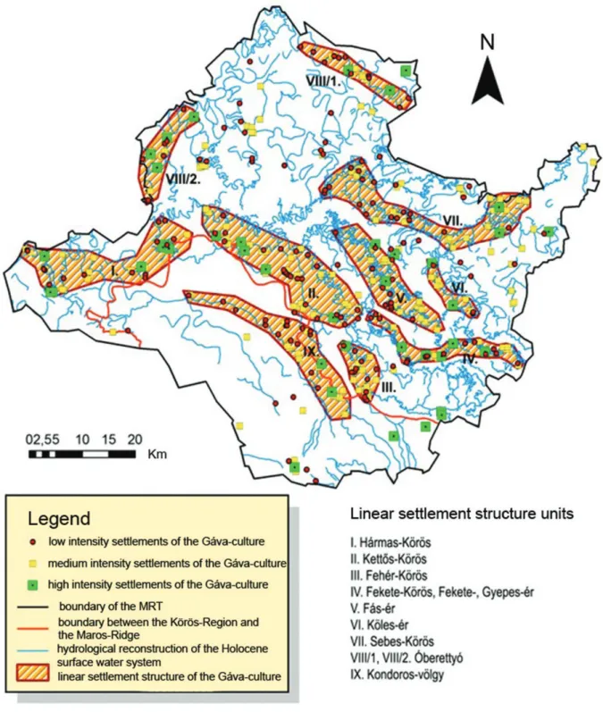
Data on settlement density mark smaller clusters of local settlements, however the typical settlement system of the entire region is dominantly characterized by the fact that human habitats are located in a linear pattern and along greater watercourses (rivers, streams) active in the Holocene (Fig. 2). Sites marking settlements of significant intensity could have fulfilled leading and organising role within the framework of the linear structural units of settlement system. These core settlements (43 altogether) seem to have been established on the basis of a well-structured and planned settling strategy. The centres were situated along a regular linear pattern ca. 3600 metres from one another, and could have possessed circular areas of a diam- eter of 2–3 kms. Large, intensive flat sites typical of riparian areas (e.g., at Baks and Poroszló) are unknown from our research area. This central and leading position could probably have been held by the fortification identified at Sarkad-Vár-tábla site at the onetime Fekete Körös riverbank and by its outskirt, Doboz-Kékfű site having been dated to HA2–HB2/HB3 periods.
Late Bronze Age linear-shaped settlement system identified in the Körös Region and the Kon- doros Valley had not developed in the territory of the fortified earthwork at Újkígyós, but instead a central, clustered structure, whose core gave place to a large hillfort and a fortified settlement, with smaller villages and lodges clustered around them, and other settlements spread sporadically in the outskirts of the zone and a smaller (20 ha) earthwork (Medgyesegy- háza-Lagzi-dűlő)6 having dated to the Late Bronze Age. Differences in the complexity and size between fortifications, as well as smaller village-like settlements within its territory indicate a multi-level settlement hierarchy and a progress in settlement concentration.
As opposed to the settlement system composed of irregular linear-shaped riparian settle- ment structural units of Gáva culture settlements, the Middle Iron Age was characterised by a settlement structure of an intrinsically different basis in terms of environment, economy and society. This era is represented by large, riparian village-like (significantly intense) core
6 Szeverényi et al. 2017.
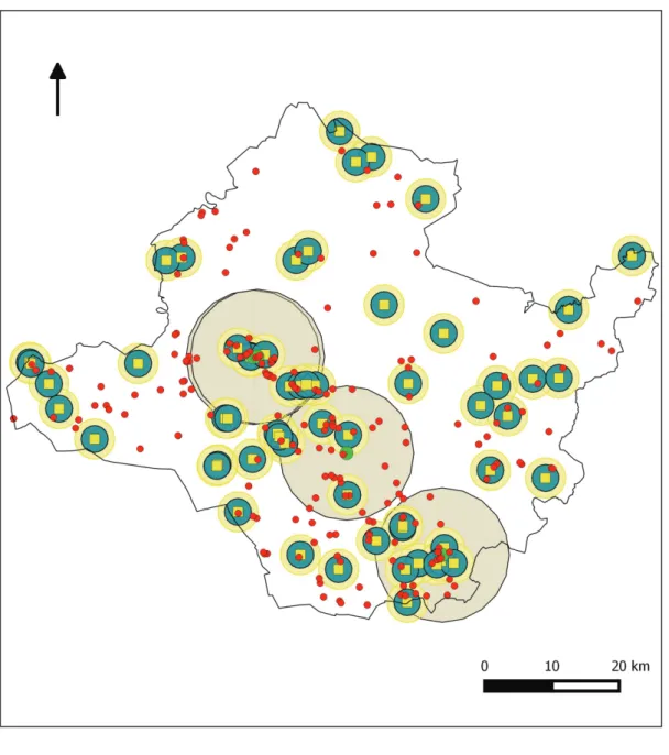
settlements consisting of more settlements and smaller clusters of (moderately intense) peren- nial settlements in their surroundings, as well as small camp-like sites (of low intensity) near the clusters.7 I managed to identify 28 settlement clusters on the basis of analysing settlement intensity indices projected on the research area (Fig. 3). Sites outside clusters were sporadic farm-like habitations (61.5%) and moderately intense perennial settlements (58.9%), both ex- isting in about the same ratio. Settlements of significant intensity outside of the settlement structural unit were found in three cases altogether.
7 Gyucha 2001.
Fig. 2. The settlement system of the Gáva culture in the study area.
247 Transformation of settlement history in the Körös Region…
In the Late Iron Age, the third period under investigation, another structure being different from the settlement system of the preceding two eras can be delineated. The basis of the so- called linear cluster shape settlement network in our case is represented by the border area among the Fehér, the Kettős and the Hármas Körös Rivers and the Maros Fan, which was intensively occupied by Celtics (Fig. 4). Beside the lengthy and wide linear clusters, one can also detect linear settlement structural units along smaller watercourses, like the Kondoros Valley, the Gyepes and Fekete Streams and the Óberettyó River, as well as irregularly and sporadically spread (moderately and slightly intensive) settlements in both the Körös Region and the Maros Fan. Two frequented clusters can be traced in the core habitation area – 40 kms Fig. 3. The settlement system of the Vekerzug culture in the study area.
from each other – that consisted of one or two significantly intensive settlements and several moderately or slightly intensive settlements, similarly to what is experienced in case of the Scythian Age.
Beginning from the second half of the Late Bronze Age settlements’ intensity had remarkably changed by the end of the Iron Age. The number of high-density settlements had gradually decreased (Gáva culture: 10.9%, Vekerzug culture 4.9%, La Tѐne culture 1,5% in relation to the total amount of settlements of the given period) similarly to medium-density sites (Gáva culture: 46.2%, Vekerzug culture: 29.3%, La Tѐne culture: 22%) (Fig. 1). Whereas the number of low-density settlements had significantly grown (Gáva culture: 42.8%, Vekerzug culture 65.7%, Fig. 4. The settlement system of the La Tène culture in the study area.
249 Transformation of settlement history in the Körös Region…
La Tѐne culture: 76.4%) (Fig. 1). It appears that gradually fewer settlements tended to play a central, leading role within the settlement system. Certain kind of centralization processes be- gan in the Middle Iron Age (settlement clusters, 28 pcs.), which intensified and culminated in the formation of two settlement clusters of central character in the Late Iron Age. It seems that besides a decreasing number of larger villages (clusters) taking central positions, remarkably smaller farmsteads and dwellings had become the bases of the settlement system. This process assumes social differentiation, a shift from the heterarchical model of settlement structure toward a hierarchical one, and the spread of a new economic model. That is based upon the population of the marginal zones (loess ridges), and the economic and social utilization of the fertile lands covering the latter, which were excellent for arable farming and grazing. The possession, accessibility and maintenance of larger grazing and arable lands were easier by means of developing more mobile hamlets.
Paleoecological analysis of the settlements
Environmental endowments were determinant of the habitation customs of each culture. We assume that the population of those cultures adapted themselves to the contemporary weath- er, hydrological and topographical conditions, which played decisive roles in choosing loca- tions of their habitats.
Gáva culture’s population did not prefer any of the three reliefs (low ploodplain, high flood- plain, terraces). They inhabited all three in about the same proportion. This fact marks the predictability and stability of the contemporary environment. “Humidity indicating” reliefs and sediments – e.g., low floodlains, lake sediments, peat bogs and saline soils – let us assume an unequivocally drier and warmer climatic phase in the Gáva culture’s period (humidity in- dicator number: 37.1). Location of the settlements of the Scythian Age Vekerzug culture does, however, shed light on an entirely different aspect. They pulled up from lower floodplains to high floodplains that were less exposed to flood risk. Terraces were inhabited in a somewhat same ratio as in the Gáva culture, although the drastic decrease of humidity indicator number (to less than its half) and a sharp decline in the number of sites on saline soils refers to a settle- ment structure that was located on secure reliefs more protected from floods and surface wa- ters (loess ridges, high floodplains, sandy surfaces) than those in preceding centuries, which can be explained by cooler climate with more precipitation and an increase in the intensity of floods. La Tène culture inhabited a variety of reliefs in a similar ratio to the Vekerzug culture.
Nonetheless, meagre changes of the ratios, the increase in humidity indicator values (21.7), as well as the repeated growth of settlings on saline soils mark a moderate and well predictable riparian activity and the improvement of climate.
Distinctions/variations of the relationship between soil endowments of the research area and the location of its settlements are the most significantly transparent in the cases of Gáva and the Vekerzug cultures. On the contrary, indices of soil use are very similar in both the Middle and the Late Iron Ages. According to statistical analyses carried out on various soil types and settlements, soil endowments influenced settling circumstances in a different way in all three investigated periods. The fertile chernozem soils, which were the most suitable for agriculture, were equally preferred to meadow soils by settlers of both the Middle and the Late Iron Ages.
We see right the opposite proportion in the Late Bronze Age. More than half of the Gáva cul- ture settlements were located on meadow soils. One finds remarkably less sites on the weakly
fertile solonetzic and marshy meadow soils characterising lower and wet areas in the Iron Age than in the Late Bronze Age. Sharp shifts in the tendencies of soil use can refer to a change in the lifestyle and alterations in cultivation methods, as well as resulted from a different utilisa- tion of natural resources necessitated by subsistence.
We conducted an analysis on the proximity to watercourses of the settlements in the research area that were associated with the Gáva culture, the Scythian Age Vekerzug culture and the La Tène culture by comparing our settlement database and the earlier introduced paleohy- drological reconstruction.8 Consequently, it seems to be general that a vast majority of the settlements of the three concerned cultures are located in a zone ranging between 50 and 500 meters from the prehistoric watercourses. We can also assert on the basis of the abovemen- tioned data that Late Bronze Age Gáva culture’s population established their sites in the main habitation zones close to watercourses, while they would use outer zones rarely. This propor- tion apparently modified at the end of the Early Iron Age and in the Middle Iron Age, as the Scythian Age Vekerzug culture began to utilise the outskirts to settle down to a greater extent beside the major habitation zones. The Late Iron Age brought a transition again in this respect.
La Tène culture pulls closer to watercourses and rarely uses the peripheric zones for habita- tion. According to the change in the distance of settlements from watercourses, we can detect habitation in proximity to watercourses (low flood levels) in the Late Bronze Age, then a de- parture from water bodies (higher flood levels) at the end of the Early and in the Middle Iron Ages, whereas settlement structure located closer to watercourses again later on in the Late Iron Age. We can associate all the aforesaid processes most probably with the climatic and paleohydrological transitions, water level and the flood intensity fluctuations of the region.
Possible reasons of settlement historical changes
building the trench system of hillforts involved the use of a massive amount of timber, which implied deforestation. Its degree depended on the structural design of defensive lines. Based on conservative estimate, at least 22 but not more than 150–200 hectares of wood had to be clear-cut for the construction of the hillfort at Újkígyós. Such an immense amount of wood was unavailable in the proximity of fortified earthworks, therefore alluvial hardwood forests in the nearby flood basin were harvested for logs. Raw materials necessitated by the construc- tions of the hillforts at Újkígyós and others in the surrounding could have been obtained from forests of the Körös Region. One of the conclusions of the Late Bronze Age and Early Iron Age deforestation processes having proved likewise in the Great Hungarian Plain and of an in- crease in the amount of precipitation was a significant growth of surface water accumulation (inundation, flood). Although inhabitants of the Gáva culture in the Körös Region were not impelled so much by the increasing flood risk that would have led to their giving up advantag- es and yields of the flood basins. This strategy is clearly discernible by the hillfort at Sarkad, which could have fulfilled a least regional defensive role within the linear settlement struc- tural unit. A great degree of the settlements is located in the low floodplains, in the riparian zones. Consequently, it was not the increasing precipitation nor the narrowing habitat caused by the floods that could primarily have incited the population of loess ridges, but rather the agricultural development detected in the Late Bronze Age and those environmental endow- ments that provided much better circumstances for animal husbandry and cereal growing.
8 Gyucha − Duffy 2008.
251 Transformation of settlement history in the Körös Region…
Soil erosion generated by deforestation in the mountainous regions9 and the Great Hungarian Plain,10 decreasing evaporation surface, increasing flow rates of rivers and the climatic period (“Little Ice Age”)11 characterised by a temperature drop culminating – all over Europe – in the transition period dated between the Late Bronze Age and the Iron Age (HB2–HC1, 900–700 B.C.) and by precipitation growth concluded significant amounts of excessive surface and ground- waters in lower areas of the Great Hungarian Plain, furthermore, the onetime flood-free high- er areas were inundated or limited by floods12 in the Early Iron Age. That process lasted until the end of the Middle Iron Age due to humid climate. Vekerzug culture inhabited higher reliefs (loess ridges) of the Körös Region and mainly the Békés–Csanád Alluvial Fan intensively as a consequence of decreasing habitats and agricultural lands in floodplains. Scythian settlements organised into clustered settlement structural units dominantly on the chernozem soils of loess ridges, high reliefs and zones being distant from watercourses adapted to the contem- porary environmental circumstances, and made efforts to utilise the opportunities provided by loessic steppes the most optimal way possible. Although the Scythian had not abandoned higher floodplain areas of the Körös Region, but they relocated the centre of gravity of their habitation area to the Békés–Csanád Alluvial Fan, where on one hand, they could cultivate arable land and horticulture at high technological level and on high-quality soil, and could, on the other hand, keep animal stock on grazing lands (of circular shape with a 3–4 km radius) belonging to the settlement clusters.
Agriculture on loess ridges having developed in the Middle Iron Age was transformed in the Late Iron Age. In addition to the clustered linear settlement structure developed in the border- land between the riparian area and loess ridge, other areas of the Körös Region and the Békés–
Csanád Alluvial Fan were sporadically populated by hamlets of the La Tène culture. Celtic settlements – similarly to those of the Scythian – are dominantly present on higher reliefs, but their number grew in lower-level riparian zones. This fact complies well with the decreasing precipitation distribution, warming and the moderation of flood intensity characterising the period. They could dominantly have kept cattle and swine on floodplain grazing lands. Hunt- ing tendency is characterised by the ratio of Late Bronze Age again, even exceeds it slightly.
Cultivation and maintenance of the high-quality (chernozem) arable and grazing lands of the loess ridge could not have been an issue due to the agricultural development experienced in the Late Iron Age (iron tools). We can assume the practice of dual economy based on the set- tlements’ location, which tried to take advantage of the endowments of both landscapes.
Conclusions
The spatial distribution of settlements on a macro- and microregional level and their dif- ferentiation and classification within this system on the basis of various attributes (size, in- tensity, structure) can contribute to a better understanding of certain changes in society. In the case of Gáva culture and its wider environment (Kyjatice culture, Gáva–Holihrady cul-
9 Willis et al. 1998; Sümegi 2003; Feurdean − Astaloş 2005; Feurdean 2005.
10 Willis et al. 1995; Sümegi 1998; Sümegi 1999; Magyari 2002; Sümegi 2004.
11 Barber et al. 2004; Bouzek 1999; Dirksen et al. 2005; Geel et al. 1999, 335-336; Kilian et al. 1995; Holzhauser et al. 2005; Kiss − Kulcsár 2007, 115–116; Mauquoy et al. 2004; Sümegi 2004, 327; Sümegi et al. 2004; Sümegi et al. 2007, 250–251; Sümegi − Jakab 2007, 77; Zolitschka et al. 2003, 90–92.
12 Metzner-Nebelsick 2000; Bóka 2008b, 159–160.
ture, Urnfield complex) we can delineate a significant settlement historical process that culminated in an expansion to areas having rarely inhabited earlier (e.g., loess ridges, mountainous areas, caves)13 and the appearance of large fortified settlements, as well as hillfort systems.14
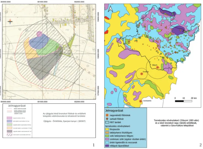
Hillforts of different extension, which could have been core locations of the con- temporary settlement structure, were em- blematic settlement forms of the pre-Gáva period. Relying on ceramic sherds and ra- diocarbon dates obtained during excava- tions, they were established on loess fans (e.g., Békés–Csanád Alluvial Fan) elevating among landscapes of greater rivers (Tisza, Maros, Köröses) in the BD–HA1 periods:
Csanádpalota-Földvár (1380–1120 cal. BC),15 Sântana-Cetatea Veche (1400–1300 cal. BC),16 Cornesti-Iarcuri (1450–1200 cal. BC)17 and Újkígyós-Örökföldek (1420–1136 cal. BC).
The involvement of high-quality cherno- zem soils and extensive pastures on high reliefs could have represented the open- ing session of the hillforts’ establishment.
All these were enabled by an “agricultural revolution” detected in several regions of Europe, too, which began to use stable and open habitats18 due to deforestation and apply new technologies (heavier plough, manuring, crop rotation) for the sake of a sustainable agricultural system.19 Water supply of the onetime Maros tributaries (Száraz Creek, Kamut Creek, Kondoros Valley) could have been of key importance in the prehistoric population of the loess ridges. Increasing precipitation rates and higher water levels (e.g., Lake Balaton)20
13 V. Szabó 2004, 149.
14 Bóka 2008b;Bóka 2017; Lichtenstein − Rózsa 2007; Szeverényi et al. 2014; Szeverényi et al. 2015; Czukor et al. 2017; V. Szabó 2017.
15 Szeverényi et al. 2015 16 Sava et al. 2019, Fig. 10.
17 Szentmiklósi et al. 2011, 828.
18 Chapman et al. 2009.
19 Kneisel 2015.
20 Sümegi et al. 2015, 249–256.
Fig. 5. Storage vessel depot from Újkígyós-Örökföldek 1
2
3
253 Transformation of settlement history in the Körös Region…
could have permanently connected the waterbeds of these tributaries to larger catchment areas by means of reaching far into the loessic steppe from the second half of the Late Bronze Age. Through these “freshwater channels” Late Bronze Age settlers could have intruded to the core areas of loess ridges, where they could construct their linear settlement structural units well known21 from the floodplains. By breaking ground of high-quality soils and involv- ing extensive pastures in practically intact, large flood-free areas of the prehistory, the Late Bronze Age community could have faced such a great economic impulse that it had to defend its accumulated products (grain and animal stocks) on one hand, and connect them to the contemporary commercial system on the other hand (Fig. 5).
The controlling and organising centres of this process could have been hillforts of various size, which supervised different size of areas (e.g., Újkígyós-Örökföldek, Csanádpalota-Föld- vár, Orosháza-Nagytatársánc) (Fig. 6.1,2). Distinctions between the complexity and exten- sion of the fortified earthworks, and smaller village-like sites within their territory indicate a multi-level settlement hierarchy and a certain process of settlement concentration. Extensive fortified settlements could possibly represent the habitations of the contemporary elite, as well as their military, political and economic centre.22
21 V. Szabó, 2004, 150; Priskin et al. 2013, Fig. 10.
22 Czukor et al. 2017, 214; V. Szabó 2017, 249.
Fig. 6. 1 – The lines of defense of the Late Bronze Age fortified earthwork at Újkígyós, 2 – Late Bronze Age large fortifications and their territory in the Southeast Great Hungarian Plain.
1 2
The irregular linear settlement structure of the Körös Region could be classified into three categories. We can associate poorly intensive sites with farmsteads or hamlets, moderately intensive ones with small villages, whereas those of significant intensity with larger villag- es and central sites.23 The village-like riparian settlements characterised by more intensive artefact assemblage within the individual linear settlement structural unit and their leading stratum could have shared the political power. The centres were situated along a regular linear pattern ca. 3600 metres from one another and could have possessed circular areas of a diam- eter of 2–3 kms. Large, intensive flat sites typical of riparian areas (e.g., at Baks and Poroszló) are unknown from our research area.24 This central and leading position could have probably been held by the fortification identified at Sarkad-Vár-tábla site at the onetime Fekete Körös riverbank and by its outskirt, Doboz-Kékfű site having been dated to HA2–HB2/HB3 periods.
Settlement system of the BD and HaB1 periods in the Great Hungarian Plain presents a strongly mosaic-like pattern. Settlement networks repre- sent different structures organically corresponding to the ecological re- lations, the economic features of cul- ture and the optimum of livelihood along greater rivers from lower, in- undated areas characterised by dense river and stream network and from loess ridges on higher reliefs. As op- posed to the hillfort system on loess ridges, which is characterised by a hi- erarchic settlement structure, one can identify a multi-centred settlement structure in areas along greater riv- ers and their floodplains, whose core could have been extensive, intensive flat settlements (Baks, Poroszló) or fortifications and their surrounding settlements (Sarkad-Doboz).
Clustered settlement structural units of the Vekerzug culture established on high reliefs of the Körös Region and loess ridges can be identified with larger individual settlement
groups, whose core is represented by settlements of significant intensity. Hungarian urban geography assigns the name “szer” (row of houses) to the settlement type represented by small groups of houses independent from each other but belonging to the same administra-
23 Bóka 2013; Bóka et al. 2017.
24 Bóka 2013; Bóka et al. 2017.
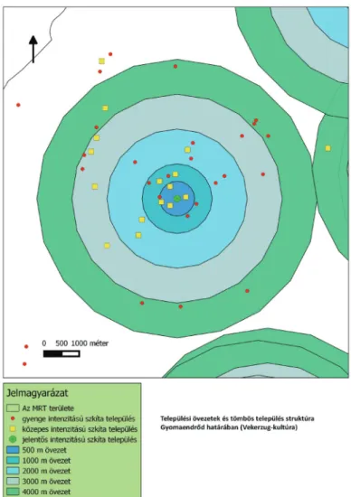
Fig. 7. Settlement clusters and their structure (Gyomaend- rőd, Vekerzug culture).
255 Transformation of settlement history in the Körös Region…
tive framework.25 Scythian Age settlement clusters very similar to the “szer”-like settlement system consisted of a varying number of settlements. Their extensions range between smaller ones of 5–6 sites and giant settlement clusters embracing 35–40 settlements (e.g., Gyula clus- ter, Gyomaendrőd cluster). These clusters are mostly located near a temporary or permanent watercourse. Their central settlements of significant intensity – sometimes more, even 2 or 3 settlements – could have covered a round area with a diameter of 3–4 kms, in which different size settlements were located sporadically, in a couple of hundred meters distance from one another. We can still consider the concentric settlement pattern and multi-centered structure in the Early Iron Age Körös Region.
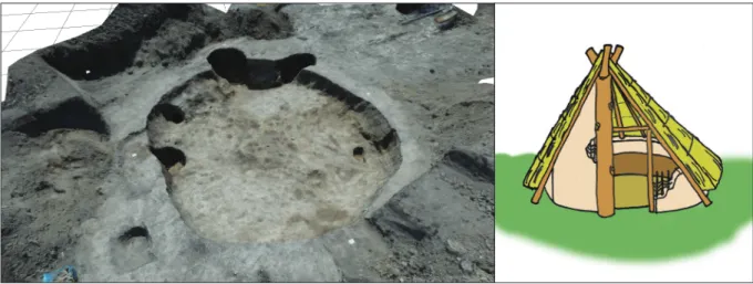
Settlement clusters identified in the Körös Region could have been under the control of in- dividual clans or minor chiefdoms. Smaller clusters and the adjacent areas could have been inhabited by a larger family, whereas giant clusters consisting of many settlements could have controlled by clans or chiefdoms (e.g., Gyomandrőd cluster) (Fig. 7). Scythian settlements in the Early and Middle Iron Ages could primarily have located on loess ridges because of cold and rainy weather, the permanent flood risk, and their economic structure. They divided flat and open areas and developed settlement structural units similar to the “szer”-like settlement groups along the onetime Maros tributaries (Kamut Creek, Hajdú Stream, Kondoros Valley), which split loess ridges, and in the border zone between the Maros Fan and the Körös Region in the HD–LT A periods. They lived settled lifestyle in their dwellings (Fig. 8), grew a multitude of cereals (mainly millet and barley), garden legumes and hemp (Gyomanedrőd-Pavlik-tanya).
Their animal stock were kept on dry grasslands within their territory, or they could have put their animals to graze inside the loess steppe by means and help of a growing number of seasonal sites, wandering from one pasture to another in certain cases. Domestic animal husbandry characterising the Vekerzug culture could have adapted to that kind of movement, therefore preferred more mobilisable breeds (cattle, sheep/goat, horse). Horse-breeding among these must be outlined as important, which is also supported by the growing practice of oat (Gyomaendrőd-Pavlik-tanya, Ebes-Zsong Valley).
25 Füzes – Kisbán 1997, 74.
Fig. 8. 3D photogrammetry and reconstruction drawing of the Scythian building in Gyomaendrőd (photo and graphic: G. Bóka).
Oppida have not been identified so far in the Körös Region, although results of the Late Iron Age settlement system indicate certain degree of centralisation processes. Accomplishment of the “Iron Age farmstead-forming process” detected in the Körös Region can be traced in other Hungarian regions, as well as in other Central and Western European areas in the Iron Age.
It is generally argued that Hungarian open settlements dated to the LT B1–C1/C2 period are small, characterised by village-like character (farmsteads, smaller villages), their site structure is built up by a few number of houses in sporadic pattern, and had been established near fresh- waters, and thread linearly along rivers, on low hilltops and terraces.
One can detect two central settlement clusters (those of Gyoma and Gyula) in the main hab- itation territory of the clustered linear settlement system in the border zone between the Maros Fan and the Körös Region, whose locations are of strategic importance (Fig. 10). The cluster at Gyula is located at the confluence of the Sebes Körös and the Kettős Körös Rivers, as well as in the intersection of the loess ridge and the riparian area. Its central role is proved by the presence of Celtic cemeteries discovered26 in its neighbourhood and the significantly intensive settlements (Gyomandrőd-Tari-tanya) characterised by an internal settlement struc- ture typical of the LTB2–C1 period. Beside the diminishing number of (2 pcs) settlement clus- ters holding central and leading role, habitations of far less extensive farmsteads or hamlets
26 Maráz 1977; Maráz 1981.
Fig. 9. 3D photogrammetry and reconstruction drawing of the La Tène building in Békésszentandrás (photo and graphic: G. Bóka).
257 Transformation of settlement history in the Körös Region…
(Békésszentandrás-Homok-hát-dűlő) became representative of the settlement system in the Körös Region (Fig. 9). This process assumes social differentiation, a shift from the heterarchical model of settlement structure toward a hierarchical one, and the spread of a dual economic model, whose fundamentals are as much the loess ridge, as the population of the Körös Re- gion, as well as the exploitation of the available natural resources, and their economic and social utilisability.
Fig. 10. Settlement clusters around medium-intensity settlements (La Tène culture).
The publications released in the topic of the dissertation
Bóka, G. 2007: Addig jár a korsó a kútra… Vaskori kutak Békéscsaba határából (The Pitcher Goes So Long to the Well… Iron Age Wells from the Boundaries of Békéscsaba). A Békés megyei múze- umok közleményei 30, 111–151.
Bóka, G. − Tugya, B. 2007: Egy békéscsabai szkíta kút állatcsontleletei (Animal Bone Assemblage of a Scythian Well at Békéscsaba). A Békés megyei múzeumok közleményei 30, 151−164.
Bóka, G. 2008a: A Körös vidék Vaskori Településeinek Régészeti Kutatása (KVR) projekt 2006. évi ered- ményei (Archaeological Research of Iron Age Settlements in the Körös Region (KVR) project outcomes of 2006). A Békés megyei múzeumok közleményei 32, 57−93.
Bóka, G. 2008b A Körös-vidéken zajló településtörténeti változások paleoökológiai háttere a késő bronzkor végén és a kora vaskorban. Egy hipotézis (Paleoecological Background of Settlement Historical Changes in the Körös Region in the Late Bronze and Early Iron Ages. A Hypthesis).
In: Bóka, G.–Martyin, E. (szerk.): Körös-menti évezredek. Régészeti ökológiai és településtörté- neti kutatások a Körös-vidéken (Millennia along the Körös. Archaeological and Settlement His- torical Researches in the Körös Region). Gyulai Katalógusok 13, Gyula, 149–171.
Bóka, G. 2012a: Településtörténeti változások a Körösvidéken a késő bronzkorban és a vaskorban. Víz- rajz, térszínek és települések (Changes in settlement patterns in the Late Bronze and Iron Ages in the Körös Region Hydrogeology, reliefs and settlements). In: Kreiter, A.–Pető, Á.–Tugya, B.
(eds): Környezet–Ember–Kultúra. A természettudományok és a régészet párbeszéde. Magyar Nemzeti Múzeum Nemzeti Örökségvédelmi Központ 2010. október 6–8-án megrendezett konferen- ciájának tanulmánykötete (Environment–Human–Culture. Dialogue between applied sciences and archaeology. Proceedings of the conference held between 6th and 8th of October 2010 by the National Heritage Protection Centre of the Hungarian National Museum). Budapest, 57−66.
Bóka, G. 2012b: Changes in the Settlement History of the Late Bronze and Iron Age Körös Region.
Hydrology, Reliefs and Settlements. Marta, L. (ed.): The Gáva culture in the Tisa Plain and Tran- sylvania – Die Gáva-Kultur in der Theißebene und Siebenbürgen. Symposium Satu Mare, 17-18 June/Juni 2011. Satu Mare – Studii sį Comunicări – Archeologie 28. Satu Mare, 23−34.
Bóka, G. 2013: Településtörténeti változások a Körös-vidéken a késő bronzkorban és a vaskorban II.
Paleoökológiai elemzés. Talajtípusok és településrendszer (Settlement Historical Changes in the Körös Region in the Late Bronze and the Iron Ages II. Paleoecological Analysis). Satu Mare – Studii şi Comunicări 29, 269−312.
Bóka, G. − Molnár, M. − Pető, Á. − Stibrányi, M. 2017: New results in the Study of Late Bronze Age and Iron Age Körös Region (Southeastern Hungary). In: Kulcsár, G.−V. Szabó G.−Kiss, V.−
Váczi, G. (eds): State of the Hungarian Bronze Age Research. Proceedings of the conference held between 17th and 18th of December 2014. Ősrégészeti Tanulmányok/Prehistoric Studies 2. Buda- pest, 161−178.
Kiss, Á. – Bóka, G. – Saláta, D. – Pető, Á. 2017: Sarkad település és környezetének földhasználat-tör- téneti vizsgálata (Land-use history of Sarkad and its surroundings). Tájökológiai Lapok 15, 9–19.
References
Barber, K. − Zolitschka, B. − Tarasov, B. − Lotter, A. F. 2004: Atlantic to Urals. The Holocene climatic record of Mid-Latitude Europe. In: Batterbee, R. W.–Gasse, F.–Stickley, C. E. (eds):
Past climate variability through Europe and Africa 6. Dordrecht, 417−442. doi: 10.1007/978-1- 4020-2121-3_20
Bouzek, J. 1999: Climatic changes and southern relations: two aspects of the East Hallstatt cultures. In:
Jerem, E.–Poroszlai, I. (eds): Archaeology of the Bronze and Iron Age. Proceedings of the Interna- tional Archaeological Conference Százhalombatta, 3–7 October 1996. Budapest, 13–25.
259 Transformation of settlement history in the Körös Region…
Bóka, G. 2008a: A Körös vidék Vaskori Településeinek Régészeti Kutatása (KVR) projekt 2006. évi ered- ményei (Archaeological Research of Iron Age Settlements in the Körös Region (KVR) project outcomes of 2006). A Békés megyei múzeumok közleményei 32, 57−93.
Bóka, G. 2008b: A Körös-vidéken zajló településtörténeti változások paleoökológiai háttere a késő bronzkor végén és a kora vaskorban. Egy hipotézis (Paleoecological Background of Settlement Historical Changes in the Körös Region in the Late Bronze and Early Iron Ages. A Hypthesis).
In: Bóka, G.–Martyin, E. (szerk.): Körös-menti évezredek. Régészeti ökológiai és településtörté- neti kutatások a Körös-vidéken (Millennia along the Körös. Archaeological and Settlement His- torical Researches in the Körös Region). Gyulai Katalógusok 13, Gyula, 149–171.
Bóka, G. 2012: Településtörténeti változások a Körösvidéken a késő bronzkorban és a vaskorban. Vízra- jz, térszínek és települések (Changes in settlement patterns in the Late Bronze and Iron Ages in the Körös Region Hydrogeology, reliefs and settlements). In: Kreiter, A.–Pető, Á.–Tugya, B.
(eds): Környezet–Ember–Kultúra. A természettudományok és a régészet párbeszéde. Magyar Nemzeti Múzeum Nemzeti Örökségvédelmi Központ 2010. október 6–8-án megrendezett konferen- ciájának tanulmánykötete (Environment–Human–Culture. Dialogue between applied sciences and archaeology. Proceedings of the conference held between 6th and 8th of October 2010 by the National Heritage Protection Centre of the Hungarian National Museum). Budapest, 57−66.
Bóka, G. 2013: Településtörténeti változások a Körös-vidéken a késő bronzkorban és a vaskorban II.
Paleoökológiai elemzés. Talajtípusok és településrendszer (Settlement Historical Changes in the Körös Region in the Late Bronze and the Iron Ages II. Paleoecological Analysis). Satu Mare – Studii şi Comunicări 29, 269−312.
Bóka, G. − Molnár, M. − Pető, Á. − Stibrányi, M. 2017: New results in the Study of Late Bronze Age and Iron Age Körös Region (Southeastern Hungary). In: Kulcsár, G.−V. Szabó G.−Kiss, V.−
Váczi, G. (eds): State of the Hungarian Bronze Age Research. Proceedings of the conference held between 17th and 18th of December 2014. Ősrégészeti Tanulmányok/Prehistoric Studies 2. Buda- pest, 161−178.
Bökönyi, S (ed.) 1992: Cultural and landscape changes in South-East Hungary I. Reports on the Gyoma- endrőd project. Budapest.
Chapman, J. − Magyari, E. − Gaydarska, B. 2009: Contrasting subsistence strategies in the Early Iron Age? New results from the Alföld Plain, Hungary, and the Thracian Plain, Bulgaria. Oxford Journal of Archaeology 28, 155−187. doi: 10.1111/j.1468-0092.2009.00323.x
Czukor, P. – Priskin, A. – Szalontai, Cs. – Szeverényi, V. 2017: Késő bronzkori földvárak a Dél- Alföldön (Late Bronze Age fortified settlements in the southern Great Pannonian Plain). In:
V. Szabó, G.–Bálint, M.–Váczi, G. (eds): A második hajdúböszörményi szitula és kapcsolatrend- szere (The second situla of Hajdúböszörmény and its relations). Studia Oppidorum Haidonicali- um 13. Budapest–Hajdúböszörmény, 211‒230.
Dirksen, V. G. − van Geel, B. − Zaitseva, G. I. 2005: Holocene climate changes and their influence on cultural development in southern Siberia and Central Asia. Geophysical Research Abstracts SRef-ID: 1607-7962/gra/EGU05-A-01436
Duffy, P. R. 2010: Complexity and autonomy in Bronze Age Europe: assessing cultural developments in Eastern Hungary. PhD Thesis. University of Michigan.
Duffy, P. R. 2014: Complexity and Autonomy in Bronze Age Europe. Assessing Cultural Developments in Eastern Hungary. Prehistoric Research in the Körös Region 1 – Archaeolingua Main Series 31, Budapest.
Ecsedy, I. – Kovács, L. – Maráz, B. – Torma, I. (szerk.) 1982: Békés megye régészeti topográfiája IV/1.
A szeghalmi járás. Magyarország Régészeti Topográfiája 6, Budapest.
Feurdean, A. 2005: Holocene forest dynamics in Northwestern Romania. The Holocene, 15, 435–446.
doi: 10.1191/0959683605hl803rp
Feurdean, A. − Astaloş, C. 2005: The impact of the human activities in the Gutăiului Mountains, Romania. Studia Universitatis Babeş-Bolyai – Geologia, 50, 63–72. doi: 10.5038/1937-8602.50.1.7
Geel, B. − Raspopov, O. M. − Renssen, H. − van der Plicht, J. − Dergachev, V. A. − Meijer, H. A. J.
1999: The role of solar forcing upon climate change. Quaternary Science Reviews 18, 331–338. doi:
10.1016/S0277-3791(98)00088-2
Gyucha, A. 2001: A szkíta kor emlékei Békés megyében. In: Havassy, P. (ed.): Hatalmasok viadalokban.
Az Alföld szkíta kora (Sie sind in Kämpfen siegreich. Das Zeitalter der Skythen in der Tiefebe- ne). Gyulai Katalógusok 10. Gyula, 117–127.
Gyucha, A. 2009: A Körösvidék kora rézkora (The Early Copper Age in the Körös Region). PhD Thesis.
Eötvös Loránd University, Budapest.
Gyucha, A. 2015: Prehistoric Village Social Dynamics. The Early Copper Age in the Körös Region. Prehis- toric Research in the Körös Region 2 – Archaeolingua Main Series 34, Budapest.
Gyucha, A. – Duffy, P. R. 2008: A Körös-vidék holocén kori vízrajza. In: Bóka, G.–Martyin, E. (eds):
Körös-menti évezredek. Régészeti ökológiai és településtörténeti kutatások a Körös-vidéken. Gyulai Katalógusok 13. Gyula, 11–41.
Holzhauser, H. − Magny, M. − Zumbühl, H. J. 2005. Glacier and lake-level variations in west-central Europe over the last 3500 years. The Holocene 15, 789–801. doi: 10.1191/0959683605hl853ra Jankovich B. D. – Makkay, J. – Szőke, B. M. (szerk.) 1989: Békés megye régészeti topográfiája IV/2. A
szarvasi járás. Magyarország Régészeti Topográfiája 8, Budapest.
Jankovich, B. D. – Medgyesi, P. – Nikolin, E. – Szatmári, I. – Torma, I. (szerk.) 1998: Békés megye régészeti topográfiája IV/3. Békés és Békéscsaba környéke. Magyarország Régészeti Topográfiája 10, Budapest.
Jerem, E. (ed.) 1996: Cultural and landscape changes in South-East Hungary II. Prehistoric, roman barbari- an and late avar settlement at Gyoma 133 (Békés County Microregion). Budapest.
Kilian, M.R. − van der Plicht, J. − van Geel, B. 1995: Dating raisedbogs: new aspects of AMS 14C wiggle matching, a reservoir effect and climatic change. Quaternary Science Reviews 14, 959–966.
doi: 10.1016/0277-3791(95)00081-X
Kiss, V. − Kulcsár, G. 2007: Bronze Age settlement patterns in the Little Balaton region and the Bala- ton Uplands. In: Zatykó, Cs.–Juhász, I.–Sümegi, P. (eds): Environmental Archaeology in Trans- danubia. Budapest, 105−116.
Kneisel, J. − Dal Corso, M. − Kirleis, W. − Taylor, N. − Tiedtke, V. 2015: The Third food Revolution?
Common Trends in Economic and Subsistence Strategies in Bronze Age Europe. In: Kneisel, J.−Dal Corso, M.−Kirleis, W.−Scholz, H.−Taylor, N.− Tiedtke, V. (eds): The Third food Rev- olution? Setting the Bronze Age table: common trends in economic and subsitstence strategies in Bronze Age Europe. Proceedings of the International Workshop „Socio-Environmental Dynamics over the Last 12,000 Years: The Creation of Landscapes III (15th – 18th April 2013)” in Kiel. Univer- sitätsforschungen zur prähistorischen Archäologie 283. Bonn, 275−287.
Lichtenstein, L. – Rózsa, Z. 2007: Bronzkori csalafintaságok a középkori Kaszaper területén. Múzeumi kutatások Csongrád megyében, 43−65.
Füzes, E.−Kisbán, E. (szerk.) 1997: A magyar nyelvterület településformái. In: Magyar Néprajz IV.
kötet (Életmód). Budapest, 11−89.
Magyari, E. 2002: Climatic versus human modification of the Late Quaternary vegetation in Eastern Hungary. PhD Thesis. University of Debrecen. Debrecen.
Maráz, B. 1977: Délkelet Magyarország La Tène kori leletanyagának kronológiai kérdései. Archaeolo- giai Értesítő 104, 47−64.
Maráz, B. 1981: A szkítakori őslakosság La Tène-kori továbbélése Kelet-Magyarországon. Régészeti adatok a Kárpát-medencei kelta-szkíta kapcsolatok kérdéséhez (On the survival of the autoch- tonous population of the Schythian Age in Eastern Hungary). A Janus Pannonius Múzeum Év- könyve 26, 97–119.
261 Transformation of settlement history in the Körös Region…
Mauquoy, D. − van Geel, B. − Blaauw, M. − Speranza, A. − van der Plicht, J. 2004: Changes in solar activity and Holocene climatic shifts derived from C14 wiggle-match dated peat deposits. The Holocene, 14, 45–52. doi: 10.1191/0959683604hl688rp
Metzner-Nebelsick, C. 2000: Early Iron Age Pastoral Nomadism in the Great Hungarian Plain – Migra- tion or Assimilation? The Thraco-Cimmerian Problem Revisited. In: Davis-Kimball, J.−Mur- phy, E.−Koryakova, L.−Yablonsky, L. (eds): Kurgans, Ritual Sites, and Settlements. Eurasian Bronze and Iron Age. British Archaeological Reports – International Series 890. Oxford, 160–185.
Priskin, A. – Czukor, P. – Szalontai, Cs. – Szeverényi, V. 2013: Research into the Structure of Late Bronze Age Settlements in the Southern Great Hungarian Plain: “Enclosed Space–Open Bor- ders” Project). Hungarian Archaeology E-journal 2013 autumn, 1−6. (http://files.archaeolingua.
hu/2013O/Upload/cikk_Priskin_EN.pdf) (last access: 12.02.2021)
Sava, V. − Gogâltan, F. − Krause, R. 2019: First Steps in the Dating of the Bronze Age Mega-Fort in Sântana-Cetatea Veche (Southwestern Romania). In: Hansen, S.−Krause, R. (eds): Bronze Age Fortresses in Europe. Universitätsforschungen zur prähistorischen Archäologie 335. Bonn, 161−176.
Sümegi, P. 1998. Az utolsó 15000 év környezeti változásai és hatásuk az emberi kultúrákra Magyaror- szágon. In: Ilon, G. (szerk.): A régésztechnikusok kézikönyve. Szombathely, 367–397.
Sümegi, P. 1999: Reconstruction of flora, soil and landscape evolution, and human impact on the Bereg Plain from late-galcial up to the present, based on palaeoecological analysis. In: Hamar, J.−
Sárkány-Kiss, A. (eds): The Upper Tisa valley. Tiscia Monograph Series 4. Szeged, 173–204.
Sümegi, P. 2003: A régészeti geológia és a történeti ökológia alapjai. Szeged.
Sümegi, P. 2004: The results of paleoenvironmental reconstruction and comparative geoarchaeological analysis for the examined area. In: Sümegi, P.–Gulyás, S. (eds): The geohistory of Bátorliget marshland. Archaeolingua Series Maior 16. Budapest, 301–335.
Sümegi, P. − Bodor, E. − Juhász, I. − Hunyadfalvi, Z. − Molnár, S. − Herbich, K. − Szegvári, G. − Imre, M. − Timár, G. 2004: A balatoni déli autópálya régészeti lelőhelyeinek környezettörténeti feldolgozása. In: Ilon, G. (szerk.): MΩMOΣ 3. Őskoros Kutatók 3. Összejövetelének konferencia- kötete. Szombathely, 399–420.
Sümegi, P. − Bodor, E. − Juhász, I. − Hunyadfalvi, Z. − Herbich, K. − Molnár, S. − Timár, G. 2007: A Ba- laton déli partján feltárt régészeti lelőhelyek környezettörténeti feldolgozása. In: Belényesy, K.–
Honti, Sz.–Kiss, V. (szerk.): Gördülő idő. Régészeti feltárások az M7-es autópálya Somogy megyei szakaszán Zamárdi és Ordacsehi között. Budapest, 241–255.
Sümegi, P. − Jakab, P. 2007: The vegetation history of Szigliget Bay. In: Zatykó, Cs.–Juhász, I.–Süme- gi, P. (eds): Environmental Archaeology in Transdanubia. Varia archaeologica Hungarica 20. Bu- dapest, 76–78.
Sümegi, P.−Náfrádi, K.−Törőcsik, T. 2015. Komplex archaeobotanikai modellek régészeti felhasz- nálása. In: Törőcsik, T.−Náfrádi, K.−Sümegi, P. (szerk.): Komplex archaeobotanika. Szeged, 249−274.
V. Szabó, G. 2004: Ház, település és településszerkezet a késő bronzkori (BD, HA, HB periódus) Tisza vidéken (Houses, settlements, and settlement structures in the Tisza region of the Late Bronze Age [periods BD, HA, HB]). In: Nagy, E. Gy.–Dani, J.–Hajdú, Zs. (szerk.): MOMOΣ 2. Őskoros Kutatók II. Összejövetele. Debrecen, 2000. november 6–8. Debrecen, 137–168.
V. Szabó, G. 2017: A Gáva-kerámiastílus kora. Az Alföld a hajdúböszörményi szitulák földbekerü- lésének időszakában (The age of the Gáva pottery style. The Great Hungarian Plain in the time of the burying of the Hajdúböszörmény situlae). In: V. Szabó, G.–Bálint, M.–Váczi, G.
(szerk.): A második hajdúböszörményi szitula és kapcsolatrendszere (The second situla of Hajdú- böszörmény and its relations). Studia Oppidorum Haidonicalium 13. Budapest–Hajdúböször- mény, 231‒278.
Szentmiklósi, A. – Heeb, B. S. – Heeb, J. – Harding, A. – Krause, R. – Becker, H. 2011: Corneş- ti-Iarcuri – a Bronze Age town in the Romanian Banat? Antiquity 85, 819−838. doi: 10.1017/
S0003598X00068332
Szeverényi, V. – Priskin, A. – Czukor, P. 2014: Csanádpalota-Juhász T. tanya (M43 55. lh.) késő bronz- kori erődített település feltárása: előzetes jelentés a 2011–2013. évi ásatások eredményeiről (Excavations at the Late Bronze Age Fortified Settlement of Csanádpalota-Juhász T. tanya (M43 Site Nr. 55): the Results of the 2011–2013 Campaigns). Móra Ferenc Múzeum Évkönyve – Új folyam 1, 29–54.
Szeverényi, V. – Priskin, A. – Czukor, P. – Torma, A. – Tóth, A. 2015: Élelmiszertermelés, telepü- lés és társadalom a késő bronzkorban Délkelet-Magyarországon: esettanulmány Csanádpalota- Földvár erődített település alapján (Subsistence, settlement and society in the Late Bronze Age of southeast Hungary: a case study from the fortified settlement of Csanádpalota-Földvár).
Móra Ferenc Múzeum Évkönyve – Új folyam 2, 41‒66.
Szeverényi, V. – Czukor, P. − Priskin, A. − Szalontai, Cs. 2017: Recent work on Late Bronze Age fortified settlements in South-east Hungary. In: Heeb, B.−Szentmiklosi, A.−Krause, R.−Wem- hoff, M. (eds): Fortifications: The Rise and Fall of Defended Sites in Late Bronze and Early Iron Age of South-East Europe. Berliner Beiträge zur Vor- und Frühgeschichte 21. Berlin, 135−148.
Willis, K. J. − Sümegi, P. − Braun, M. − Tóth, A. 1995: The Late Quaternary environmental history of Bátorliget, N. E. Hungary. Palaeogeography, Palaeoclimatology, Palaeoecology 118, 25–47. doi:
10.1016/0031-0182(95)00004-6
Willis, K. J. − Sümegi, P. − Braun, M. − Bennett, K. D. − Tóth, A. 1998. Prehistoric land degradation in Hungary: who, how and why? Antiquity 72, 101–113. doi: 10.1017/S0003598X00086312
Zolitschka, B. − Behre, K. − Schneider, J. 2003: Human and climatic impact ont he environment as dervied from colluvial, fluvial and lacustrine archives–examples from the Bronze Age to the Migration period, Germany. Quaternary Science Reviews 22, 81–100. doi: 10.1016/S0277- 3791(02)00182-8