Image based multi-level environment analysis (Képi alapú többszint ˝u környezetelemzés)
A thesis submitted for the
Doctoral Degree of the Hungarian Academy of Sciences (D.Sc.)
Csaba Benedek, Ph.D.
Institute for Computer Science and Control Hungarian Academy of Sciences
Budapest, 2019
Acknowledgements
I gratefully acknowledge the help of my closest colleagues at the Machine Perception Research Laboratory (MPLab) of the Institute for Computer Science and Control of Hungarian Academy of Sciences (MTA SZTAKI), giving always very significant im- pacts on my ongoing works. I pay special thanks to Professor Tamás Szirányi, the head of the laboratory, my former supervisor and mentor for more than 15 years.
Several B.Sc., M.Sc. and Ph.D. students working with my supervision from the Pázmány Péter Catholic University (PPCU) and the Budapest University of Tech- nology and Economics (BME) have greatly contributed to the conducted research.
I thank all of them, especially my Ph.D. students Attila Börcs, Balázs Nagy and Yahya Ibrahim, and among my many talented M.Sc. students Bence Gálai and Oszkár Józsa who contributed as co-authors to several joint publications.
I also thank on both professional and personal levels to my senior and doctoral student colleagues in MPLab: Dániel Baráth, Iván Eichhardt, Levente Hajder, László Havasi, Zsolt Jankó, Anita Keszler, Ákos Kiss, Attila Kiss, Levente Kovács, András Kriston, András Majdik, Andrea Manno-Kovács, Zoltán Pusztai, Zoltán Rózsa, Maha Shaday- deh, László Spórás, Zoltán Szlávik, László Tizedes, Domonkos Varga, Ákos Utasi.
Thanks to Mónika Barti and Anikó Vágvölgyi from the administration staff, and to all undergraduates and software developers of the laboratory. I would like to thank Eszter Nagy from the SZTAKI Library for help in organizing my conference trips and for managing our publication records for several years.
My colleagues from various collaborating institutes also provided valuable contribu- tions: Josiane Zerubia and Xavier Descombes from INRIA Sophia Antipolis France, Marco Martorella and Fabrizio Berizzi from the University of Pisa, Zoltán Kató from the University of Szeged, László Jakab and Olivér Krammer from the Department of Electronic Technology of BME, and Dmitry Chetverikov from MTA SZTAKI. I thank Anuj Srivastava for hosting me at the Florida State University as a postdoc visitor.
I also thank the deans of the PPCU Faculty of Information Technology and Bionics, Judit Nyékyné Gaizler, Péter Szolgay and Kristóf Iván, and department heads at BME,
Gábor Harsányi, László Szirmay-Kalos and Bálint Kiss for giving me the opportunities to lecture and supervise students in the universities.
During my research, I had the opportunity to work with a large variety of particular test data. The remotely sensed satellite images and Lidar point clouds were provided by the Airbus Defence and Space Hungary Ltd, the French Defense Ministry and the Liama Sino-French Laboratory. I received radar images from the university of Pisa, Italy. Obtaining our own mobile and terrestrial Lidar laser scanners in the MPLab was possible through the internal R&D grant of MTA SZTAKI, and the Infrastructure Grant of the Hungarian Academy of Sciences, respectively. We received further laser scanning data from Budapest Közút Zrt.
The work introduced in this thesis was partially supported by various projects and grants: Janos Bolyai Research Fellowship of the Hungarian Academy of Sciences, researcher initiated projects of the National Research, Development and Innovation Fund (grants NKFIA K-120233 and KH-125681), the Széchenyi 2020 Program at PPCU (grant EFOP-3.6.2-16-2017-00013), the DUSIREF project of the European Space Agency under the PECS-HU framework, the PROACTIVE EU FP7-SECURITY Project, the i4D (intergated4D) project of MTA SZTAKI, the Comprehensive Re- mote Sensing Data Analysispostdoctoral project of the Hungarian Scientific Research Fund (grant OTKA-101598), APIS and MEDUSA European Defence Agency (EDA) projects, and the New Hungary Development Plan (TÁMOP) project at BME.
I am very grateful to my lovely Lívi and Lóci, to my whole family and to all of my friends who always believed in me and supported me in all possible ways.
Abstract
In this thesis novel approaches are proposed for multi-level scene interpretation based on various 2D and 3D imaging sources. We focus on measurements of up-top-date optical cameras, radars and laser scanners both in terrestrial and airborne configu- rations. Our central aim is to explore common problems appearing in different ap- plication domains, and address them by joint methodological approaches. To ensure the theoretical basis of the new models, the surveys and algorithmic developments are performed in well established Bayesian frameworks, or use recent results of ma- chine learning research. Low level scene understanding functions are formulated as various image segmentation problems, where we take the advantages of the Markov Random Field (MRF) probabilistic framework, which admits us to consider in parallel data-dependent and prior constraints, to get smooth, noiseless, and observation consis- tent classification outputs. At object level scene analysis, we rely on the literature of Marked Point Process (MPP) approaches, which consider strong geometric and prior interaction constraints in object population modeling. Particularly, we introduce key developments in spatial hierarchical decomposition of the observed scenarios, and in temporal extension of complex MRF and MPP models. Additional contributions are also presented in efficient feature extraction, probabilistic modeling of natural pro- cesses and feature integration via local innovations in the model structures. In the last part, we propose new models and algorithms suited to processing the measurements of novel Lidar laser scanners. The research work in this direction enables us to target new application areas, but also implies various new challenges due to the particular mea- surement characteristics of the sensors. Besides Bayesian techniques, we utilize here the latest deep neural network solutions, fitted to various problems of environment per- ception. We show by several experiments that the proposed contributions embedded into a strict mathematical toolkit can significantly improve the results in real world 2D/3D test images and videos, for applications on video surveillance, environment monitoring, autonomous driving, remote sensing and optical industrial inspection.
Contents
1 Introduction 1
2 Fundamentals 7
2.1 Markovian classification models . . . 9
2.1.1 Markov Random Fields, Gibbs Potentials and Observation Processes . . . 9
2.1.2 Bayesian labeling approach and the Potts model . . . 10
2.1.3 MRF based image segmentation . . . 11
2.1.4 MRF Optimization . . . 12
2.1.5 Mixed Markov Models . . . 13
2.2 Object population extraction with Marked Point Processes . . . 14
2.2.1 Definition of Marked Point Processes . . . 14
2.2.2 MPP energy functions . . . 15
2.2.3 MPP optimization . . . 17
2.3 Advanced machine learning techniques . . . 19
2.4 Methodological contributions of the thesis . . . 19
3 Multi-layer label fusion models 21 3.1 Label fusion models in computer vision . . . 22
3.2 A label fusion model for object motion detection . . . 23
3.2.1 Feature selection . . . 24
3.2.2 Multi-layer segmentation model . . . 25
3.2.3 L3MRF Optimization . . . 27
3.2.4 Experiments on object motion detection . . . 27
3.3 Long term change detection in aerial photos . . . 29
3.3.1 Image model and feature extraction . . . 30
3.3.2 A Conditional Mixed Markov image segmentation model . . . 33
3.3.3 Experiments on long term change detection . . . 36
3.4 Parameter settings in multi-layer segmentation models . . . 39
3.5 Conclusions of the chapter . . . 40
4 Multitemporal data analysis with Marked Point Processes 41 4.1 Introducing the time dimension in MPP models . . . 42
4.2 Object level change detection . . . 42
4.2.1 Building development monitoring - problem definition . . . 42
4.2.2 Feature selection . . . 43
4.2.3 Multitemporal MPP configuration model and optimization . . . 48
4.2.4 Experimental study of the mMPP model . . . 49
4.3 A point process model for target sequence analysis . . . 52
4.3.1 Application on moving target analysis in ISAR image sequences . . . 52
4.3.2 Problem definition and notations . . . 53
4.3.3 Data preprocessing in a bottom-up approach . . . 54
4.3.4 Multiframe Marked Point Process Model . . . 55
4.3.5 Multiframe MPP optimization . . . 56
4.3.6 Experimental results on target sequence analysis . . . 57
4.4 Parameter settings in dynamic MPP models . . . 59
4.5 Conclusions of the chapter . . . 60
5 Multi-level object population analysis with an EMPP model 61 5.1 A hierarchical MPP approach . . . 62
5.2 Problem formulation and notations . . . 64
5.3 EMPP energy model . . . 65
5.4 Multi-level MPP optimization . . . 66
5.5 Applications of the EMPP model . . . 67
5.5.1 Built-in area analysis in aerial and satellite images . . . 68
5.5.2 Traffic monitoring based on Lidar data . . . 71
5.5.3 Automatic optical inspection of printed circuit boards . . . 73
5.6 Benchmark database and evaluation methodology . . . 75
5.7 Experimental results . . . 76
5.8 Conclusion of the chapter . . . 80
6 4D environment perception 81 6.1 Introduction to 4D environment perception . . . 82
6.2 People localization in multi-camera systems . . . 84
6.2.1 A new approach on multi-view people localization . . . 85
6.2.2 Silhouette based feature extraction . . . 87
6.2.3 3D Marked Point Process model . . . 88
6.2.4 Evaluation of multi-camera people localization . . . 89
6.3 A Lidar based 4D people surveillance approach . . . 91
6.3.1 Foreground extraction in Lidar point cloud sequences . . . 92
6.3.2 Pedestrian detection and tracking . . . 96
6.3.3 Lidar based gait analysis . . . 97
6.3.4 Action recognition . . . 100
6.3.5 Dataset for evaluation . . . 102
6.3.6 Experiments and discussion . . . 103
6.4 Urban scene analysis with real time Lidar sensors and dense MLS data background 109 6.4.1 Ground-obstacle classification . . . 110
6.4.2 Fast object separation and bounding box estimation . . . 111
6.4.3 Deep learning based object recognition in the RMB Lidar data . . . 112
6.4.4 Semantic MLS point cloud classification with a 3D CNN model . . . 113
6.4.5 Multimodal point cloud registration . . . 114
6.4.6 Frame level cross-modal change detection . . . 116
6.4.7 Evaluation . . . 118
6.5 Conclusions of the chapter . . . 120
7 Conclusions of the thesis 121 7.1 Methods used in the research work . . . 122
7.2 New scientific results . . . 123
7.3 Examples for application . . . 133
7.4 Lecturing and domestic publications . . . 136
A Summary of abbreviations and notations 137 B Supplement regarding multi-layer label fusion models 141 C Supplement regarding Multitemporal Marked Point Processes 145 C.1 Object level change detection . . . 145
C.2 A point process model for target sequence analysis . . . 148
C.2.1 Foreground-background separation of ISAR frames . . . 148
C.2.2 FmMPP energy optimization . . . 149
C.2.3 Quantitative evaluation of the FmMPP method . . . 149 D Supplement regarding Embedded Marked Point Processes 153
E Supplement regarding 4D environment perception 159
References 182
List of Figures
1.1 Examples for different data modalities used in the thesis . . . 2
2.1 Demonstration of asegmentationand anobject population extractiontask. . . 8
2.2 Illustration of simple connections in MRFs . . . 12
2.3 Demonstration of MRF based supervised image segmentation with three classes . . 12
2.4 Possible interactions in mixed Markov models . . . 13
2.5 Marked Point Process example . . . 14
2.6 Calculation of theI(u, v)interaction potentials . . . 16
2.7 Selected examples of population extraction with MPP models . . . 18
3.1 Demonstration of object motion detection and long term change detection . . . 23
3.2 Feature selection in the multi-layer MRF model . . . 24
3.3 Structure of the proposed three-layer MRF (L3MRF) model . . . 26
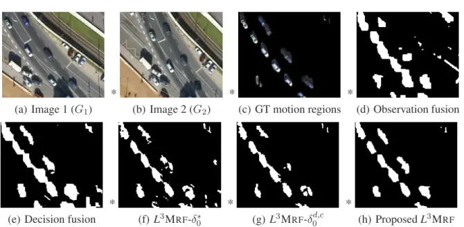
3.4 Four selected test image pairs for qualitative comparison . . . 28
3.5 Numerical comparison of the proposed model (L3MRF) to five reference methods . 28 3.6 Evaluation of the proposedL3MRFmodel versus different fusion approaches . . . 29
3.7 Feature selection for long term change detection . . . 30
3.8 Feature histograms with statistical approximations . . . 31
3.9 Illustration of the 2 dimensionalhg andhc histograms . . . 32
3.10 Structure of the proposed model and overview of the segmentation process. . . 33
3.11 Demonstration of intra- and inter-layer connections . . . 34
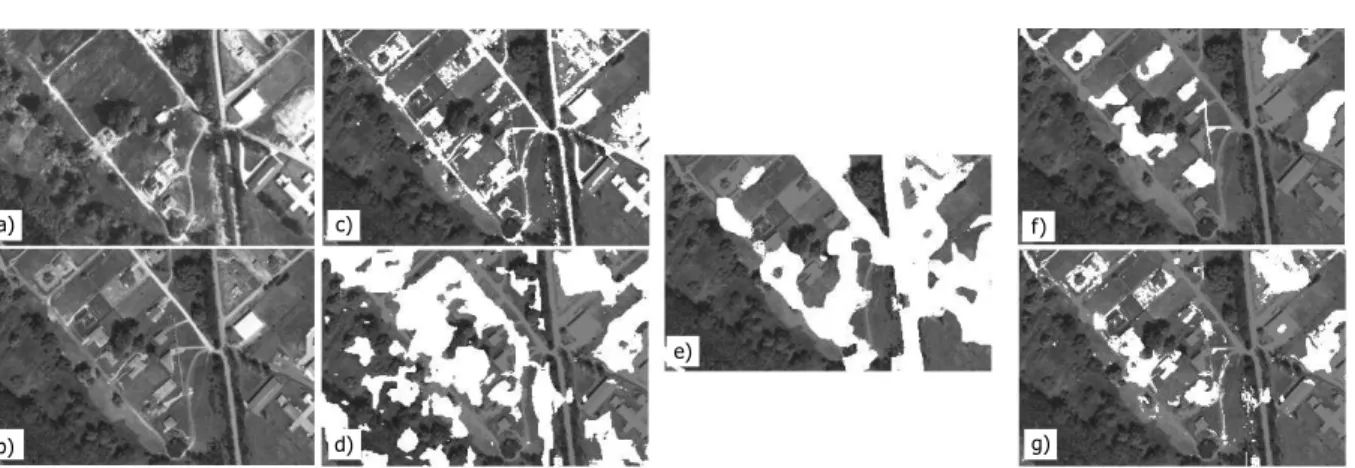
3.12 Qualitative comparison of the change detection results with different methods . . . 36
3.13 Quantitative comparison of the proposed CXM technique to four previous methods 37 3.14 Impacts of the multi-layer CXM structure for the quality of the change mask. . . . 39
4.1 Low level change detection . . . 43
4.2 Building candidate regions . . . 44
4.3 Plot of the nonlinear feature domain mapping function . . . 46
4.4 Utility of the color roof and shadow features . . . 46
4.5 Illustration of the feature maps in the BUDAPEST2008 image . . . 47
4.6 Results on BUDAPESTand BEIJINGimage pairs . . . 51
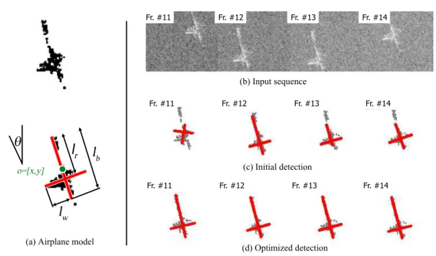
4.7 Target representation in an ISAR image . . . 53
4.8 Dominant scatterer detection problem . . . 54
4.9 Center alignment and target line extraction results . . . 57
4.10 Sample frames from theSHIP2-SHIP7data sets . . . 58
4.11 Airplane detection example . . . 59
5.1 Structure elements of the EMPP model. . . 64
5.2 Results of built-in area analysis, displayed at three different scales . . . 68
5.3 Built-in area analysis - model components . . . 69
5.4 Vehicle detection from airborne Lidar data . . . 70
5.5 Sample results on traffic analysis . . . 71
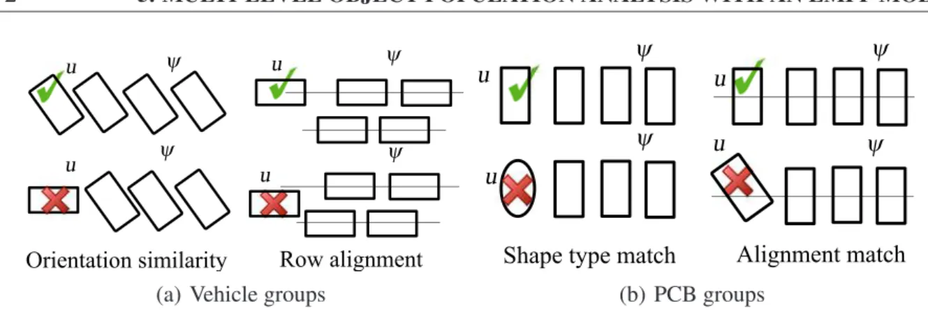
5.6 Grouping energies for traffic monitoring and PCB analysis applications . . . 72
5.7 Processing workflow for Mobile Laser Scanning (MLS) data . . . 73
5.8 PCB inspection: Feature demonstration for unary term calculation . . . 74
5.9 Results of PCB analysis . . . 75
6.1 Data comparison of two different Lidar sensors . . . 83
6.2 Multiview people detection and height estimation . . . 84
6.3 Foreground model and texture feature validation . . . 85
6.4 Side view sketch of silhouette projection . . . 86
6.5 Feature definition . . . 87
6.6 Cylinder objects modeling people in the 3D scene, and the intersection feature . . . 89
6.7 Detection examples by the proposed 3DMPP model in theCity Centersequence . . 90
6.8 Lidar based surveillance . . . 91
6.9 Point cloud recording and range image formation with a RMB Lidar sensor . . . . 92
6.10 Foreground segmentation in a range image part with three different methods . . . . 94
6.11 Components of the dynamic MRF model . . . 95
6.12 Backprojection of the range image labels to the point cloud. . . 96
6.13 Silhouette projection demonstration . . . 98
6.14 Lidar based GEI generation . . . 99
6.15 Activity recognition . . . 100
6.16 ADM (left) and AXOR (right) maps for the different actions. . . 101
6.17 Structure of the used convolutional neural networks . . . 102
6.18 Foreground detection withBasic MoG,uniMRFandDMRFmodels . . . 103
6.19 Quantitative evaluation of LGEI based matching . . . 106
6.20 Performance figures based on various factors . . . 106
6.21 Result ofactivity recognitionin an outdoor test sequence . . . 108
6.22 Workflow of instant environment perception . . . 109
6.23 RMB Lidar data segmentation and object detection . . . 110
6.24 The step by step demonstration of the object detection algorithm . . . 111
6.25 Object classification workflow for RMB Lidar frames . . . 113
6.26 Point cloud segmentation result with a 3D CNN . . . 114
6.27 Velodyne HDL-64E to Riegl VMX-450 point cloud registration results . . . 115
6.28 Change detection between reference MLS data and instant RMB Lidar frames . . . 117
6.29 Demonstration of the proposed MRF based change detection process . . . 118
7.1 Flowchart of the i4D system . . . 134
7.2 Live demonstration of our Lidar-based person tracker . . . 136
B.1 Comparative segmentations with different test methods and Ground Truth . . . 143
C.1 Evaluation of the single view building model. . . 147
C.2 Demonstration of the foreground-background segmentation . . . 149
D.1 Steps of the bottom-up entity proposal process . . . 154
D.2 Building analysis - sample results for chimney detection . . . 157
D.3 Qualitative comparison of the sMPP and EMPP configurations . . . 157
E.1 Multimodal Velodyne HDL-64E to Riegl VMX-450 registration results . . . 161
List of Tables
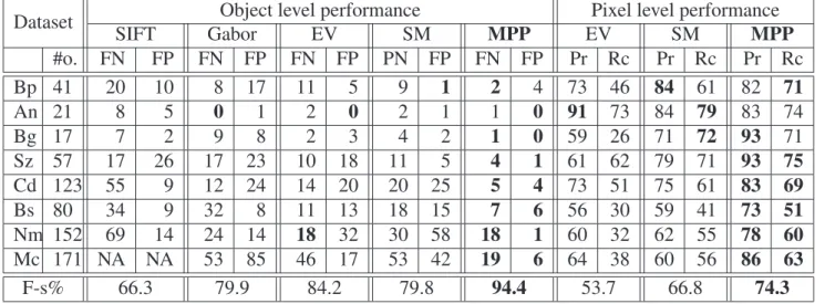
4.1 Numerical comparison of the SIFT, Gabor, EV, SM and the proposed methods . . . 50
5.1 Object and group level evaluation of the the proposed EMPP model . . . 76
5.2 Child level evaluation of the the proposed EMPP model . . . 77
5.3 Object level and pixel level F-scores in traffic analysis . . . 78
5.4 PCB inspection task: Comparison of the child level performance . . . 79
5.5 Average computational time and parent object number . . . 79
5.6 Experiment repeatability for the vehicle detection task . . . 80
5.7 Distribution of the number of falsely grouped objects . . . 80
6.1 Comparison of the POM and the proposed 3DMPP models . . . 91
6.2 Point level evaluation of foreground detection . . . 104
6.3 Evaluation results of the compared methods . . . 106
6.4 The confusion matrix of action recognition . . . 107
6.5 Evaluation of the object classification and change detection . . . 119
C.1 Quantitative evaluation results. . . 145
C.2 Evaluation of the different steps in the FmMPP model . . . 152
E.1 Comparison of Connected Component Analysis and theHierarchal Grid Model . . 162
E.2 Results of multimodal RMB Lidar and MLS point cloud registration . . . 162
Chapter 1 Introduction
This thesis deals with selected problems of machine perception, targeting the automated interpre- tation of the observed static or dynamic environment based on various image-like measurements.
Scene understanding is based nowadays far beyond on conventional image processing approaches dealing with standard grayscale or RGB photos. Multi-camera systems, high-speed cameras, radar systems, depth and thermal sensors or laser scanners may be used concurrently to support a given application, therefore proposing a competitive solution for a problem should not only mean to construct the best pattern recognition algorithm but also to chose the best a hardware-software configuration. Some data modalities used in the thesis are demonstrated in Fig. 1.1.
Besides the wide choice of the technologies, we can witness today a quick development of the available sensors in terms of spatial and temporal resolution, number of information channels, level of noise etc. For this reason, by implementing efficient environment perception systems we should answer various challenges of automatic feature extraction, object and event recognition, machine learning, indexing and content-based retrieval. First, the developed methodologies should be able to deal with various data sources and they should by highly scalable. This property enables flexible sensor fusion and the replacement of outdated sensors with novel ones providing improved data quality, without complete re-structuring of existing software systems. Second, the increased spatial resolution and dimension of the observed data implies that in a single measurement segment one may detect multiple effects on different scales, demanding recognizer algorithms which perform hierarchical interpretation of the content. As an example, in a very high resolution aerial photo, we can jointly analyze macro-level urban or forest regions, separate different districts and roads of the cities, extract and cluster buildings, or focus on smaller objects such as vehicles or street furniture [71, 72]. Third, we should also efficiently utilize the multiple available scales of the time dimen- sion. While object motion information can be directly extracted through pixel-by-pixel comparison of the consecutive frames in an image sequence withvideo frame rate; comparing measurements with several months or years time differences captured from the same area needs a high level
(a) Aerial image (b) Radar (ISAR) image (c) Aerial Lidar scan
(d) Printed circuit image (e) Security camera image (f) Terrestrial Lidar scan Figure 1.1: Examples for different data modalities used in the thesis
modeling approach. The accomplished research work should point therefore towards obtaining a complex system, where the provided information of various data sources is organized into a uni- fied hierarchical scene model, enabling multi-modal representation, recognition and comparison of entities, through combining object level analysis with low level feature extraction.
From a functional point of view, the methods proposed in the thesis present either general pre- processing steps of different early vision applications, or contribute to higher level object based scene analysis modules. In the first case, the introduced models rely on low level local features ex- tracted from the sensor measurements, such as the pixel color values in images, or texture descrip- tors calculated over small rectangular image parts. The output is a classification (or segmentation) of the observation, which can be interpreted as a semantic labeling of the raw data. For example, in a video frame we can separate the foreground and background pixels, or in an aerial Lidar point cloud roof and terrain regions can be distinguished. Although the classification is primarily based on the extracted local features, which provide posterior (observation dependent) information for the process, additional prior constraints are also exploited to decrease the artifacts due to noise and ambiguities of the input data. One of the simplest, but often used prior condition is the con- nectivity: we can assume in several problems that the classification should result in homogeneous regions, e.g. in images neighboring pixels correspond usually to the same semantic class.
Markov Random Fields (MRFs) [73] are widely used classification tools since the early eight- ies, since they are able to simultaneously embed a data model, reflecting the knowledge on the
measurements; and prior constraints, such as spatial smoothness of the solution through a graph based image representation. Since conventional MRFs show some limitations regarding context dependent class modeling, different modified schemes have been recently proposed to increase their flexibility. Triplet Markov fields [74] contain an auxiliary latent process which can be used to describe various subclasses of each class in different manners. Mixed Markov models [75] extend MRFs by admitting data-dependent links between the processing nodes, which fact enables intro- ducing configurable structures in feature integration. Conditional Random Fields (CRFs) directly model the data-driven posterior distributions of the segmentation classes [76]. On their positive points, the above Markovian segmentation approaches are robust and well established for many problems [77]. However, as it will be explained in Chapter 2in details, the MRF concept offers only a general framework, which has a high degree of freedom. In particularly, a couple of key issues should be efficiently addressed for a given real-world problem. The first one is extracting appropriate features and building a proper probabilistic model of each semantic class. The second key point is developing an appropriate model structure, which consists of simple interactive ele- ments. The arrangement and dialogue of these units is responsible for smoothing the segmentation map or integrating the effects of different features. Choosing the right dimension of the field is also a critical step. MRFs can be either defined on 2D lattices, or on 3D voxel models, but projecting a high dimensional problem to a lower dimensional domain is also a frequently used option. For example, for segmenting a point cloud, a straightforward approach is to construct the MRF in the 3D Euclidean space of the measurements. However, if the point cloud data was recorded by a 2.5D sensor moving on a fixed trajectory, range image representation may provide more efficient results, which is less affected by artifacts of sensor noise and occlusion.
We propose in this thesis novel solutions regarding many of the above mentioned aspects fol- lowing demands of real applications. On one hand we combine various statistical features to solve different change detection problems, and explore the connections between different 2D image and 3D point cloud based descriptors. On the other hand, we investigate the efficiency of various possi- ble model structures both in terms of scalability and in practical problem solving performance. We will propose new complex and flexible low level inference algorithms between various measured features and prior knowledge. Dealing with higher dimensional data we pay particular attention to reduce the complexity of the model structures, to save computational time and keep the modeling process tractable.
A higher level of visual data interpretation can be based on object level analysis of the scene.
Object extraction is a crucial step in several perception applications, starting from remotely sensed data analysis, through optical fabric inspection systems, until video surveillance.
Object detection techniques in the literature follow either a bottom-up, or an inverse (top-down) approach. The straightforward bottom-up techniques [78] construct the objects from primitives,
like blobs, edge parts or corners in images. Although these methods can be fast, they may fail if the primitives cannot be reliably detected. We can mention here Hough transform or mathematical morphology based methods [79] as examples, however these approaches show limitations in cases of dense populations with several adjacent objects. To increase robustness, it is common to fol- low the Hypothesis Generation-Acceptance (HGA) scheme [80, 81]. Here the accuracy of object proposition is not crucial, as false candidates can be eliminated in the verification step. However, objects missed by the generation process cannot be recovered later, which may result in several false negatives. On the other hand, generating too many object hypotheses (e.g. applying exhaus- tive search) slows down the detection process significantly. Finally, conventional HGA techniques search for separate objects instead of global object configurations, disregarding population-level features such as overlapping, relative alignment, color similarity or spatial distance of the neigh- boring objects [82].
To overcome the above drawbacks, recentinverse methods [83] assign a fitness value to each possible object configuration, and an optimization process attempts to find the configuration with the highest confidence. This way, flexible object appearance models can be adopted, and it is also straightforward to incorporate prior shape information and object interactions. However, this inverse approach needs to perform a computationally expensive search in a high dimensional pop- ulation space, where local maxima of the fitness function can mislead the optimization.
Using the above terminology, MRFs can also be considered as inverse techniques. However staying at pixel level in the graph nodes, we find only very limited options to consider geometri- cal information [84, 85]. Marked Point Processes (MPP) [83, 86] offer an efficient extension of MRFs, as they work with objects as variables instead of with pixels, considering that the number of variables (i.e. number of objects) is also unknown. MPPs embed prior constraints and data models within the same density, therefore similarly to MRFs, efficient algorithms for model optimization [87, 88, 89] and parameter estimation [90, 91] are available. Recent MPP applications range from 2D [92, 93] and 3D object extraction [9, 94] in various environments, to 1D signal modeling [95]
or target tracking [96].
Marked Point Processes have previously been used for various population counting problems, dealing with a large number of objects which have low varieties in shape. MPP models can effi- ciently handle these situations, through jointly describing individual objects by various data terms, and using information from entity interactions by prescribing the (soft) fulfillment of prior geo- metric constraints [86]. In this way, one can extract configurations which are composed of sim- ilarly shaped and sized entities such as buildings [97], trees [98, 99], birds [87, 88, 94], or boats [90] from remotely sensed data, cell nuclei from medical images [100], galaxies in space applica- tions [93] or people in video surveillance scenarios [101]. While the computational complexity of MPP optimization may mean bottleneck for some applications, various efficient techniques have
been proposed to speed up the energy minimization process, such as the Multiple Birth and Death (MBD) [87] algorithm or the parallel Reversible-Jump Markov Chain Monte Carlo (RJMCMC) sampling process [89].
Although the above applications show clear practical advantages of conventional MPP based solutions, neither the time dimension of the measurements nor the spatial hierarchical decomposi- tion of the scene are addressed in the referred previous works of the literature. Therefore, this thesis presents contributions focusing on temporal and spatial extensions of the original MPP framework, by expansively analyzing the needs and alternative directions for the solutions, and demonstrating the advantages of the improvements in real problem environments.
The temporal dimension appears in two different aspects. The first problem is object-level change detection in image pairs, where low level approaches are combined with geometric object extraction by a multi temporal MPP (mMPP) model. The result is an object population, where each object is marked as unchanged, changed, new, or disappeared between the selected two time instances, typically based on measurements with several months or years time differences.
A second task is tracking a moving target across several frames in time sequences of very low quality measurements, such as radar images. For this purpose, a novel Multiframe MPP (FmMPP) framework is proposed, which simultaneously considers the consistency of the observed data and the fitted objects in the individual images, and also exploits interaction constraints between the object parameters in the consecutive frames of the sequence. Following the Markovian approach, here each target sample may only affect objects in its neighboring frames directly, limiting the number of interactions for efficient sequence analysis.
Another major targeted issue is spatial hierarchical content modeling. Classical MPP-based image analysis models [83, 87] focus purely on the object level of the scene. Simple prior in- teraction constraints such as non-overlapping or parallel alignment are often utilized to refine the accuracy of detection, but in this way only very limited amount of high level structural information can be exploited from the global scenario. In various applications however, investigation of object grouping patterns and the decomposition of objects to smaller parts (i.e. sub-objects) are relevant issues. We propose therefore a hierarchical MPP extension, called the Embedded Marked Point Process (EMPP) model, which encapsulates on one hand a hierarchical description between ob- jects and object parts as a parent-child relationship, and on the other hand it allows corresponding objects to form coherent object groups, by a Bayesian segmentation of the population.
Machine based perception and analysis of the dynamic 3D (i.e. 4D, where the 4th dimension is time) environment is nowadays a hot topic in research and engineering, following the quick progress of autonomous driving, security and smart city related applications. Whileconventional electro-optical cameras are still important visual information sources, recently released Lidar range
sensors offer alternative approaches for scene analysis, by directly measuring 3D geometric infor- mation from the environment. Using the Lidar technology, the most important limitation is cur- rently a necessary trade-off between the spatial and the temporal resolution of the available sensors, which makes difficult to observe and analyze small details of the scenes in real time. Important re- search issues are therefore the exploration of new tasks which can be handled by these new sorts of 4D measurements, the adaption of conventional image processing algorithms, structures for voxel- based scene representation and vision related machine learning methodologies to Lidar data, and the fusion of measurements of various Lidar and optical sensors to obtain a more complete scene model. We deal in this thesis with three selected problem families of 4D environment percep- tion. First, we propose a new Bayesian approach for person localization and height estimation in a multi-camera system. Second, we construct a novel people surveillance framework based on the measurements of a single Rotating Multi-beam (RMB) Lidar sensor, implementing motion detec- tion, moving object separation, tracking, and biometric person identification via Lidar-based gait descriptors. Third, we introduce a new workflow with various novel algorithms, for large-scale urban environment analysis based on a car-mounted RMB Lidar, also using a very detailed 3D reference map obtained via laser scanning.
This thesis uses the basic concepts and results of probability theory (e.g. random variables, probability density functions, Bayes rule etc.), and machine learning (neural networks, supervised training strategies) which are supposed to be familiar for the Readers.
The outline of the dissertation is as follows. Chapter2presents a short introduction to stochas- tic image segmentation, object population extraction and machine learning approaches, by intro- ducing the data types, general notations and basic mathematical tools used in the following parts of the thesis. The scientific contributions of the Author are presented in Chapters3-6. Each of these chapters corresponds to a Thesis Group listed in the Conclusion part in Section 7.2, by giving the background of the selected problems and the main steps of the solution, particularly focusing on the validation of the new scientific results which is performed in experimental ways in most cases. In Chapter3novel multi-layer Markovian label fusion models are proposed for two differ- ent change detection applications. Chapter4deals with multitemporal object level scene analysis for tasks of building change detection in remotely sensed optical image pairs, and moving target tracking in radar image sequences. In Chapter 5we give a complex multi-level stochastic model for spatial scene decomposition, and demonstrate its usability in three very different application fields. Finally, in Chapter 6 we introduce our above detailed contributions connected to the 4D environment perception topic. A short conclusion and a summary of the new scientific results is given in Chapter7. For helping the Reader, AppendixAprovides a detailed overview on the used abbreviations and notations, while Appendices B-E include some additional figures, tables and pseudo codes connected to the main contributions of the thesis.
Chapter 2
Fundamentals
In this thesis, the various sensor measurements at given time instances are represented either as 2D digital images or as 3D point clouds. Both cases can be completed with a temporal dimension obtaining image or point cloud sequences.
A digital image is defined over a two dimensional pixel latticeShaving a finite sizeSW×SH, where s ∈ S denotes a single pixel. The pixels’ observation values represent grayscale or RGB color information, depth values etc. or any descriptors calculated from the raw sensor measure- ments by spatio-temporal filtering or feature fusion.
A point cloudL is by definition an unordered set ofl points: L = {p1, . . . , pl}, where each point,p∈ L, is described by its(x, y, z)position coordinates in a 3D Euclidean world coordinate system. Additional parameters, such as intensity, color values or further sensor-specific parameters may also be associated with the points.
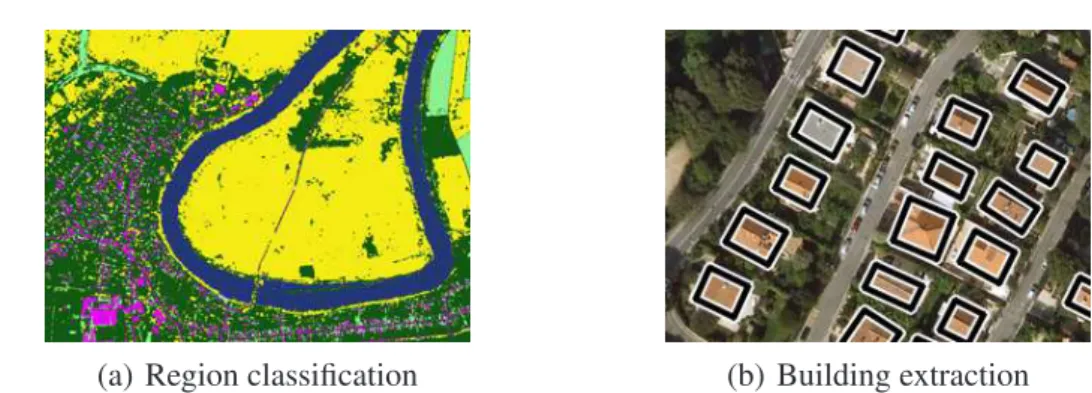
Although several different techniques are discussed in the thesis with various goals and model structures, they are strongly connected from the point of view theoretical foundations and method- ologies: many of them can be formulated either aslow level segmentation(or classification) prob- lems or asobject population extractiontasks (see examples in Fig. 2.1).
Segmentation(or classification) can be formally considered as a labeling task where each local element (pixel of the image or point of the point cloud) gets a label from a J-element label set corresponding to J different segmentation classes. In other words, a J-colored image or point cloud is generated for a given input. Following statisticalinverseapproaches, we should be able to assign a fitness (or probability) value to all the J#el possible segmentations1, based on the current measurements (calledobservation), domain specific knowledge about the classes, and prior constraints, in a way that higher fitness values correspond to semantically better solutions.
By object population extraction, we mean the detection of an unknown number of entities from a preliminary defined object library. Here the fitness function needs to characterize any of
1#elmarks here the number of pixels, or points
(a) Region classification (b) Building extraction
Figure 2.1: Demonstration of asegmentationand anobject population extractiontask for aerial images.
the possible entity configurations. The objects are described by geometric shapes such as ellipses or rectangles, while the fitness function evaluates how the independent objects fit the image data and it may also consider pre-defined interaction constraints.
To overcome the course of dimensionality, the fitness functions are usually modularly defined:
they can be decomposed into individual subterms, and the domain of each subterm consists only of a few nearby pixels or objects. In this way, if we change locally the segmentation map or the population, we should not re-calculate the whole fitness function, only those subterms, which are affected by the selected entities. This property significantly decreases the computational complex- ity of iterative optimization techniques [102, 103].
An efficient Bayesian approach can be based on a graph representation, where each node of the graph corresponds to a structural model element, such as a pixel of the image, or an object of the population. We define edges between two nodes, if the corresponding entities influence each other directly, i.e. there is a subterm of the fitness function which depends on both elements. For example, to ensure the spatial smoothness of the segmented images, one can prescribe that the neighboring pixels should have the same labels in the vast majority of cases [104].
Since the seminal work of Geman and Geman [102], Markov Random Fields (MRFs) and their variants such as Mixed Markov models offer powerful tools to ensure contextual classification in image or point set segmentation tasks. Marked Point Process (MPP) models have been introduced in computer vision more recently, as a natural object-level extension of MRFs. In the following part of the chapter we give the formal definitions and algorithmic steps regarding MRF based data segmentation and MPP based object population extraction. The concepts and notations introduced here will be used in the following parts of the thesis.
2.1 Markovian classification models
2.1.1 Markov Random Fields, Gibbs Potentials and Observation Processes
A Markov Random Field (MRF) can be defined over an undirected graph G = (V, ε), where V = {υi|i = 1, . . . N}marks the set of nodes, andε is the set of edges. Two nodesυi andυk are neighbors, if there is an edgeeik ∈εconnecting them. The set of points which are neighbors of a nodeυ (i.e. the neighborhood ofυ) is denoted byNυ, while we mark withN ={Nυ|υ ∈ V}the neighborhood system of the graph.
A classification problem can be interpreted as a labeling task over the nodes. Using a finite label setΛ ={l1, l2, . . . , lJ}, we assign a unique labelς(υ)∈Λto each nodeυ ∈V. We mean by aglobal labeling̟ the enumeration of the nodes with their corresponding labels:
̟ ={[υ, ς(υ)]| ∀υ ∈V}. (2.1) Let us denote byΥthe (finite) set of all the possible global labellings (̟ ∈Υ).
In some cases, instead of a global labeling, we need to deal with the labeling of a given sub- graph. The subconfiguration of̟with respect a subsetX ⊆Vis denoted by̟X ={[υ, ς(υ)]| ∀υ ∈ X }.
In the next step, we define Markov Random Fields. As usual, Markov property means here that the label of a given node depends only on its neighbors directly.
Definition 1 (Markov Random Field) X is a Markov Random Field (MRF), with respect to a graphG, if the following two conditions hold:
• for all̟ ∈Υ;P(X=̟)>0
• for everyυ ∈Vand̟ ∈Υ: P(ς(υ)|̟V\{υ}) = P(ς(υ)|̟Nυ).
Discussion about MRFs is most convenient by defining the neighborhood system via thecliquesof the graph. A subsetC ⊆Vis a clique if every pair of distinct nodes inCare neighbors. Cdenotes a set of cliques.
To characterize thefitnessof the different global labellings, a Gibbs measure is defined on Υ.
LetV be a potential function which assigns a real numberVX(̟)to the subconfiguration̟X. V defines an energyU(̟)onΥby
U(̟) = X
X∈2V
VX(̟). (2.2)
where2V denotes the set of the subsets ofV.
Definition 2 (Gibbs distribution) A Gibbs distribution is a probability measure π onΥwith the following representation:
π(̟) = 1 Z exp
−U(̟)
(2.3) whereZis a normalizing constant or partition function:
Z = X
̟∈Υ
exp −U(̟)
. (2.4)
IfVX(̟) = 0wheneverX /∈C, thenV is called a nearest neighbor potential.
The following theorem is the principle of most MRF applications in computer vision [102]:
Theorem 1 (Hammersley-Clifford)X is an MRF with respect to the neighborhood system N if and only ifπ(̟) = P(X = ̟)is a Gibbs distribution with nearest neighbor Gibbs potentialV, that is
π(̟) = 1
Z exp −X
C∈C
VC(̟)
!
(2.5)
We mean by observation arbitrary measurements from real world processes (such as image sources) assigned to the nodes of the graph. In image processing, usually the pixels’ color values or simple textural responses are used, but any other local features can also be calculated. In general, we only prescribe that the observation process assigns aDdimensional real vector,f(υ)∈RD, to selected graph nodes. The global observation over the graph is marked by
F={[υ, f(υ)]| ∀υ ∈O}whereO ⊆V. (2.6) MRF based classification models use two assumptions. First, each class label li ∈ Λ cor- responds to a random process, which generates the observation value f(υ) at υ according to a locally specified probability density function(pdf), pυ,i(λ) = P(f(υ) = λ|ς(υ) = li). Second, local observations are conditionally independent, given the global labeling:
P(F|̟) = Y
υ∈O
P(f(υ)|ς(υ)). (2.7)
2.1.2 Bayesian labeling approach and the Potts model
Let X be an MRF on graph G = (V, ε), with (a priori) clique potentials {VC(̟) | C ∈ C}. Consider an observation processFonG. The goal is to find the labeling̟, which is the maximumb a posteriori (MAP) estimate, i.e. the labeling with the highest probability givenF:
̟b = argmax
̟∈Υ
P(̟|F). (2.8)
Following Bayes’ rule and eq. (2.7),
P(̟|F) = P(F|̟)P(̟)
P(F) = 1 P(F)
"
Y
υ∈O
P (f(υ)|ς(υ))
#
P(̟) (2.9)
Based on the Hammersley-Clifford theorem,P(̟)follows a Gibbs distribution:
P(̟) = π(̟) = 1
Z exp −X
C∈C
VC(̟)
!
(2.10) whileP(F)andZ (in the Gibbs distribution) are independent of the current value of̟. Using also the monotonicity of the logarithm function and equations (2.8), (2.9), (2.10), the optimal global labeling can be written into the following form:
b
̟ = argmin
̟∈Υ
(X
υ∈O
−logP (f(υ)|ς(υ)) +X
C∈C
VC(̟) )
. (2.11)
Note that due to the conditional independence of the observations at the different nodes, the fact that the prior fieldπ(̟)is an MRF implies that theπ(̟|F)posterior field is also an MRF. In this case the−logP(f(υ)|ς(υ))quantity can be considered as the potential of asingleton clique{υ}.
2.1.3 MRF based image segmentation
A widely used implementation of the above Bayesian labeling framework for image segmentation is based on the Potts model [104]. Assume that the problem is defined over the 2D latticeSand we have a measurement vectorf(s)∈RDat each pixels. The goal is to segment the input lattice with J pixel clusters corresponding toJ random processes (l1, . . . , lJ), where the clusters of the pixels are consistent with the local measurements, and the segmentation issmooth, i.e. pixels having the same cluster form connected regions. Here by the definition of G, we assign to each pixel of the input lattice a unique node of the graph. One can simply use a first orderedneighborhood, were each pixel has four neighbors. In this case, the cliques of the graph are singletons or doubletons as shown in Fig. 2.2. As a consequence, the prior term π(̟) = P(̟)of the MRF energy function is defined by the doubleton clique potentials. According to the Potts model, the prior probability term is responsible for getting smooth connected components in the segmented image, so that we give penalty terms to each neighboring pair of nodes whose labels are different. For anyr, υ ∈ V node pairs, which fulfillυ ∈Nr,{r, υ} ∈Cis a clique of the graph, with the potential:
V{r,υ}(̟) =
−δ if ς(r) = ς(υ)
+δ if ς(r)6=ς(υ) (2.12)
whereδ≥0is a constant.
A sample MRF based segmentation result, with the demonstration of the role of the Potts smoothing term, is shown in Fig. 2.3.
Figure 2.2: Illustration of simple connections in MRFs: (a) first ordered neighborhood of a selected node on the lattice, (b) ‘singleton’ clique, (c) doubleton clique
(a) (b) (c)
Figure 2.3: Demonstration of MRF based supervised image segmentation with three classes: (a) input image with the training regions, (b) pixel-by-pixel segmentation without using node interactions, (c) result of the Potts model with MMD optimization [53]
2.1.4 MRF Optimization
In applications using the MRF models, the quality of the classification depends both on the ap- propriate probabilistic model of the classes, and on the optimization technique which finds a good global labeling with respect to eq. (2.11). The latter factor is a key issue, since finding the global optimum is NP hard [105]. On the other hand, stochastic optimizers using simulated annealing (SA) [102, 103] and graph cut techniques [105] have proved to be practically efficient offering a ground to validate different energy models.
The results shown in the following chapters have been generated by either the determinis- tic Modified Metropolis (MMD) [106, 107] relaxation algorithm or by the fast graph-cut based optimization technique [105]. Detailed overviews on the various optimization approaches, and tutorials on MRF based image segmentation can be found in thePh.D. dissertationof the Author [53], and in several books and monographs dealing with the topic [73, 77].
Figure 2.4: Possible interactions in mixed Markov models. Four different configurations, where A and B regular nodes may directly interact. Empty circles mark address nodes, continuous lines are edges, dotted arrows denote address pointers.
2.1.5 Mixed Markov Models
Mixed Markov models have been originally proposed for gene regulatory network analysis [75], and extend the modeling capabilities of Markov random fields: besides prior static connections, they enable using observation-dependentdynamiclinks between the processing nodes. This prop- erty allows encoding interactions that occur only in a certain context and are absent in all others.
A mixed Markov model – similarly to a conventional MRF – is defined over a graph G = (V, ε), whereVandεdenote again the sets of nodes and edges, respectively. A label, i.e. a random vari- ableς(υ), is assigned to each nodeυ ∈Vas well, and the node labels over the graph determine a global labeling̟as defined by Formula (2.1).
However in mixed Markov models two types of nodes are discriminated: VRcontainsregular nodesandVAis the set ofaddress nodes(V =VR∪VA, VR∩VA = ∅). Regular nodesr ∈ VR have the same roles as nodes in MRFs: the corresponding variableς(r)will encode a segmentation label getting values from a finite, application dependent label set. On the other hand address nodes provide configurable links in the graph by creating pointers to other (regular) nodes. Thus for a given address node a ∈ VA, the domain of its ‘label’ ς(a) is the set VR∪ {nil}. In the case of ς(a)6= nil, let us denote byς⋆(a)the label of the regular node addressed bya:
ς⋆(a) := ς(ς(a)). (2.13)
There is no restriction on the graph topology: edges can link any two nodes. The edges define the set of cliques ofG, which is denoted again byC.
In a given configuration, two regular nodes may interact directly if they are connected by a static edge or by a chain of a static edge and dynamic address pointers: four typical configurations of connection are demonstrated in Fig.2.4. More specifically, with notation for each cliqueC ∈C: ςC = {ς(υ)|υ ∈ C} andςCA = {ς⋆(a)a ∈ VA∩C, ς(a) 6= nil} the prior probability of a given global labeling̟is given by:
P(̟) = 1 Z
Y
C∈C
exp
−VC ςC, ςCA (2.14)
(a) (b) (c)
Figure 2.5: Marked Point Process example: (a) building population as a realization of a point process (b) rectangle model of a selected building, (c) parameters of the marked object [10]
whereVC is aC→Rclique potential function, which has a ‘low’ value if the labels within the set ςC∪ςCAare semantically consistent, whileVC is ‘high’ otherwise. ScalarZ =P
̟P(̟)is again a normalizing constant, which could be calculated over all the possible global labelings. Note that a detailed analysis of analytical and computational properties of mixed Markov models can be found in [75], which confirms the efficiency of the approach in probabilistic inference.
2.2 Object population extraction with Marked Point Processes
Similarly to Markov Random Fields, the Marked Point Process (MPP) methods use a graph-based representation for semantic content modeling. However, in MPPs the graph nodes are associated with geometric objects instead of low level pixels or point cloud elements. In this way an MPP model enables to characterize whole populations instead of individual objects, through exploiting information from entity interactions. Following the classical Markovian approach, each object may only affect itsneighborsdirectly. This property limits the number of interactions in the population and results in a compact description of the global scene, which can be analyzed efficiently.
For easier discussion, in this chapter we introduce MPP models purely over 2D pixel lattices, dealing with 2D objects. While most of the object detection tasks discussed in this thesis are handled indeed as 2D pattern recognition problems, we will show in later chapters, that the model extension to 2.5D or 3D (spatial) scenes is quite straightforward.
2.2.1 Definition of Marked Point Processes
In statistics, a random process is called point process, if it can generate a set of isolated points either in space or time, or in even more general spaces. In this thesis we will mainly use a discrete 2D point process, whose realization is a set of an arbitrary number of points over a pixel latticeS:
o={o1, o2, . . . , on}, n∈ {0,1,2, . . .}, ∀i: oi ∈S. (2.15)
A sample task for using point processes in image processing is detecting buildings in aerial images, as shown in Fig.2.5(a), where each point corresponds to a building center. However, modeling our objects with point-wise entities is often an insufficient abstraction. For example, in high resolution aerial photos building shapes can often be efficiently approximated by rectangles (Fig. 2.5(b)). To include object geometry in the model, we assign markers to the points. As shown in Fig. 2.5(c), a rectangle can be defined by the center point o ∈ S, the orientation θ ∈ [−90◦,+90◦] and the perpendicular side lengthseLandel. In this case the marker is a 3D parameter vector(θ, eL, el).
Taking a general case, let us denote byuan object candidate of the scene whose imaged shape over lattice S is represented by a plane figure from a preliminary fixed shape library. In this thesis, ellipses, rectangles and isosceles triangles are used. We will model each marked object by its reference pointo, the global orientation θ and further shape dependent parameters such as major and minor axes for ellipses, the perpendicular side lengths for rectangles, and a side-altitude pair for triangles. With denoting by Pthe domain of the markers, theH parameter space of the individual objects (i.e. u∈H) is obtained asH=S×P.
A configuration of an MPP model, denoted byω, is a population of marked objects:
ω ={u1, . . . , un}, ∀i:ui ∈H, (2.16) where the number of objects, n, is an arbitrary integer, which is initially unknown in population extraction tasks. Consequently, the object configuration space,Ω, has the following form:
Ω = [∞
n=0
Ωn, Ωn=
{u1, . . . , un} ⊂Hn . (2.17) Next, we define a ∼neighborhood relation between the objects of a given ω configuration. For example, we can prescribe for objects u, v ∈ ω, that u ∼ v iff the distance between the object centers is lower than a predefined threshold. The neighborhood of objectuinωis:
Nu(ω) = {v ∈ω|u∼v}. (2.18)
2.2.2 MPP energy functions
Object populations in MPP models are evaluated by simultaneously considering the input measure- ments (e.g. images), and prior application specific constraints about object geometry and interac- tions. Let us denote by F the union of all image features derived from the input data. For char- acterizing a given ω configuration based on F, we introduce a non-homogenous data-dependent Gibbs distribution (see eq.(2.3)) on the population space:
PF(ω) = P(ω|F) = 1
Z ·exp
−ΦF(ω)
(2.19)
Figure 2.6: Calculation of the I(u, v) interaction potentials: intersections of rectangles are denoted by striped areas
with aZ normalizing constant:
Z =X
ω∈Ω
exp −ΦF(ω)
, (2.20)
ΦF(ω)is called the configuration energy. Following the energy decomposition approach discussed earlier by MRFs (eq. (2.5)), we obtain ΦF(ω)as the sum of simple components, which can be calculated by considering small subconfigurations only. More specifically, we distinguish unary (or singleton) terms (A) defined on individual objects, andInteraction terms (I(u, v)), concerning neighboring objects:
ΦF(ω) =X
u∈ω
A(u) +γ· X
u,v∈ω u∼v
I(u, v) (2.21)
γ >0is a weighting factor between the unary and interaction terms, and it should be calibrated in each application in a case-by-case basis. In general, both theA(u)andI(u, v)terms may depend on theFobservation. However, it is a frequent strategy that only the unary terms depend onF, so that they evaluate the object candidates as a function of the local image data. On the other hand, the I(u, v) components may implement prior geometric constraints, such as neighboring objects should not overlap, or they should have similar orientation. Denoting byRu ⊂ Sthe set of image pixels covered by the geometric figure of object u, a simple interaction term penalizing object intersection can be calculated as:
I(u, v) = #(Ru∩Rv)
#(Ru∪Rv) (2.22)
where#denotes the set cardinality. (See also Fig. 2.6.)
In the following, we will only use the subscriptF, when we want to particularly emphasize that a given MPP energy term depends on the measurement data (eg. AF(u), ΦF(ω)). In several clear situations the subscript notation will be omitted to preserve the simplicity of formalism.
2.2.3 MPP optimization
The optimal object populationωbin an MPP model can be taken as the MAP configuration estimate:
b
ω= argmax
ω∈Ω
PF(ω) = argmin
ω∈Ω
ΦF(ω). (2.23)
However, finding ωb needs to perform an efficient search in the high dimension population space with a non-convex energy function. Ensuring high quality object configurations by algorithms with feasible computation complexity is crucial in several applications, therefore we can find an extensive bibliography of MPP energy minimization techniques. Most previous approaches use the iterative Reversible Jump Markov Chain Monte Carlo (RJMCMC) scheme [108, 109], where each iteration consists in perturbing one or a couple of objects using various kernels such as birth, death, translation, rotation or dilation. Here experiments show that the rejection rate, especially for the birth move, may induce a heavy computation time. Besides, one should be very careful when decreasing the temperature, because at low temperature, it is difficult to add objects to the population.
A recent alternative approach, called the Multiple Birth and Death Dynamics technique (MBD) [87] attempts to overcome several ones from the above mentioned limitations. Unlike following a discrete jump-diffusion scheme like in RJMCMC, the MBD optimization method defines a con- tinuous time stochastic evolution of the object population, which aims to converge to the optimal configuration. The evolution under consideration is a birth-and-death equilibrium dynamics on the configuration space, embedded into a Simulated Annealing (SA) process, where the temperature of the system tends to zero in time. The final step is the discretization of this non-stationary dynam- ics: the resulting discrete process is a non-homogeneous Markov chain with transition probabilities depending on the temperature, energy function and discretization step. In practice, the MBD algo- rithm evolves the population of objects by alternating purely stochastic object generation (birth) and removal (death) steps in a SA framework. In contrast to the above RJMCMC implementations, each birth step of MBD consists of adding several random objects to the current configuration, which is allowed due to the discretization trick. Using MBD, there is no rejection during the birth step, therefore high energetic objects can still be added independently of the temperature param- eter. Thus the final result is much less sensitive to the tuning of the SA temperature decreasing process, which can be achieved faster. Due to these properties, in selected remote sensing tasks (bird and tree detection) [87] the optimization with MBD proved to be around ten times faster than RJMCMC with similar quality results. On the other hand, we note that parallel sampling in MBD implementations is less straightforward than regarding the RJMCMC relaxation [89].
In the thesis, we will propose different structural modifications of the Multiple Birth and Death Dynamic (MBD) adopted to our addressed problems. For a deeper understanding of this approach, we introduce here the steps of the basic MBD algorithm [87]:
(a) Flamingos cINRIA (b) Building detection (c) Vehicle detection Figure 2.7: Selected examples of population extraction with MPP models: (a) flamingo detection in aerial images [87], (b) building extraction in satellite photos [10], (c) vehicle detection from Lidar data [34]
1. Initialization: calculate aPb() : S → Rbirth map using the Finput data, which assigns to each pixelsa pseudo probability valuePb(s)estimating how likelysis an object center.
2. Main program: initialize the inverse temperature parameterβ = β0 and the discretization stepδ =δ0 and alternate birth and death steps.
(a) Birth step: for each pixel s ∈ S, if there is no object with center s in the current configurationω, choose birth with probabilityδPb(s).
If birth is chosen ins:
• generate a new objectuwith centers
• set the object parameters (marks ofu) randomly based on prior knowledge
• adduto the current configurationω.
(b) Death step: Consider the configuration of objects ω = {u1, . . . , un}and sort it from the highest to the lowes value of the unary (data) termϕY(u). For each objectutaken in this order compute the death rate as follows:
dω(u) = δaω(u)
1 +δaω(u), whereaω(u) = exph
−β
ΦF(ω/{u})−ΦF(ω)i and killuwith probabilitydω(u)
3. Convergence test: if the process has not converged, increase the inverse temperature β and decrease the discretization stepδby a geometric scheme and go back to the birth step. The convergence is obtained when all the objects added during the birth step, and only these ones, have been killed during the death step.
Selected state-of-the-art results for MPP based object population extraction in different appli- cations using different input sources are shown in Fig. 2.7. Examples (b) and (c) are directly related to the thesis.
2.3 Advanced machine learning techniques
The previously discussed Bayesian image classification techniques can be efficiently applied, if either a color/texture based statistical description can specify the semantically corresponding re- gions (see MRFs), or strong geometric constraints can be adapted for object shape description and object population modeling (MPPs).
In various situations, for example in semantic urban scene segmentation, detection of objects with diverse elastic shapes (e.g. pedestrians, various types of vehicles), or biometric identifica- tion based on visual features, such assumptions cannot be set, and neural network (NN) based solutions are often taken as first options. While in MRF/MPP models we directly involve our prior knowledge (such as geometric features) in the modeling process, in NN based methods, the information used for classification should be entirely extracted from the training data, thus the qualitative and quantitative parameters of the training dataset are critical factors. Another crucial issue of NN recognizers is the efficient feature selection. Conventional NNs used handcrafted fea- tures specified for each problem separately, thus the feature engineering step was a significant part of algorithm development. This tendency changed by introducing the feature learning strategies of deep neural networks (DNNs), which has grabbed a very intensive focus of computer vision research on machine learning approaches in the recent years [111]. Apart from feature learning, the main contribution of DNNs is that they can also learn strong contextual dependencies from training samples, leading us close to a human-like holistic scene interpretation. On the other hand, while some DNN-based attempts on population counting [112] or object tracking [113] have al- ready been proposed, their superiority versus probabilistic or geometric approaches have not yet been thoroughly demonstrated in these domains.
This thesis does not provide research results on generally improving deep learning methodolo- gies, but as we detail in Chapter6, we utilize the combination of existing DNN architectures and learning strategies in multiple occasions for solving novel environment perception tasks, including Lidar-based person identification, 3D object recognition and 3D point cloud scene segmentation.
2.4 Methodological contributions of the thesis
Although Markov Random Field (MRF) and Marked Point Process (MPP) models provide estab- lished tools for classification and population modeling tasks, they face a couple of limitations, which are disadvantageous in various real work tasks.
In MRF based segmentation models, the integration of multiple information sources is a key issue. Earlier proposed feature fusion approaches, such as observation modeling by multinomial feature distributions, or using simple pixel-by-pixel operations on various label maps, often yield
insufficient performance. In Chapter 3, we propose novel Markovian label fusion models, which enable flexible integration of various observation based and prior knowledge based descriptors in a modular framework. We also introduce a multi-layer Mixed Markov model, which exploits the probabilistic connection modeling capabilities of Mixed Markov models in the multi-layer segmentation process.
The conventional MPP models are extended in this thesis both regarding the temporal and the spatial dimensions. In Chapter 4we introduce multitemporal MPP frameworks dealing with object level change detection and moving target tracking tasks. From a technical point of view, this extension needs the definition of various data-based or prior interaction terms between object examples from different time layers, apart from the usual intra-layer constraints of eq. (2.22).
Regarding spatial scene content decomposition, in Chapter5we propose an Embedded MPP model consisting of three hierarchical levels, namely object groups, super objects and object parts. The super (orparent) objects play a similar role as regular objects in MPP models, while the object parts (or child objects) are also marked objects with a predefined set of possible geometric attributes, and they are connected to the parents through additional markers. On the other hand, the object groups are interpreted as sub-populations, which may contain any number of (parent) objects, and various local geometric constraints can be prescribed for the included members.
Another key point in MPP models is the probabilistic approach for object proposal. In several previous MPP applications [108], the generation of object candidates followed prior (e.g. Poisson) distributions. On the contrary, we apply a data driven birth process to accelerate the convergence of MBD, proposing relevant objects with higher probability based on various image features. In addition, we calculate not only a probability map for the object centers, but also estimate the expected object appearances through low-level descriptors. This approach uses a similar idea to the Data Driven MCMC scheme of image segmentation [110]. However, while in [110] the importance proposal probabilitiesof the moves are used by a jump-diffusion process, we should embed the data driven exploration steps into the MBD framework.
Chapter6presents various results from the field of 4D environment perception. For new imag- ing sensors or sensor configurations, such as the rotating multi-beam Lidar, or the up-to-date high resolution multi-camera systems, even the possible application areas are not completely explored yet. Therefore, several recently published techniques rely on ad-hoc and heuristic methodological approaches. In this thesis, we take the advantage of the established MRF, MPP model concepts fused with various up-to-date machine learning techniques to improve the automatic detection per- formance under realistic outdoor circumstances.
![Figure 2.3: Demonstration of MRF based supervised image segmentation with three classes: (a) input image with the training regions, (b) pixel-by-pixel segmentation without using node interactions, (c) result of the Potts model with MMD optimization [53]](https://thumb-eu.123doks.com/thumbv2/9dokorg/1244150.96503/28.892.101.783.441.640/figure-demonstration-supervised-segmentation-training-segmentation-interactions-optimization.webp)