Kakucs-Turján
a Middle Bronze Age multi-layered
fortified settlement in Central Hungary
Studien zur Archäologie in Ostmitteleuropa
Studia nad Pradziejami Europy Środkowej 18
The Kakucs-Turján archaeological site was investigated by a Polish-Hungarian-German research team of archaeologists and various specialists. This volume contains the first, preliminary results of their work, giving the reader an insight into the complex history of the Bronze Age settlement and its economic activities as reflected in the multi-layered stratigraphy of the site.
The currently analysed materials from Kakucs-Turján may help to indicate the basic parameters of the development and functioning of the Middle Bronze Age Vatya culture; on the one hand strongly based on local tradition, on the other contextualized within a wider network covering the Carpathian Basin.
Mateusz Jaeger, Gabriella Kulcsár, Nicole Taylor, Robert Staniuk (eds.)
In Kommission bei Dr. Rudolf Habelt GmbH
Mat eusz Jaeger , G abriella K ulc sár , Nic ole T aylor , Rob er t Staniuk ( eds .) Kakucs- Turján
SAO SPEŚ 18
fortified settlement in Central Hungary
Mateusz Jaeger, Gabriella Kulcsár, Nicole Taylor,
Studien zur Archäologie in Ostmitteleuropa
·
Studia nad Pradziejami Europy Środkowej Band / Tom 18Kakucs-Turján
a Middle Bronze Age multi-layered fortified settlement in Central Hungary
Mateusz Jaeger, Gabriella Kulcsár, Nicole Taylor, Robert Staniuk (eds.)
In Kommission bei Dr. Rudolf Habelt GmbH, Bonn 2018
Herausgegeben von / Redaktorzy
The publication was fi nanced by
Studien zur Archäologie in Ostmitteleuropa Studia nad Pradziejami Europy Środkowej Band / Tom 18
Johannes Müller, Kiel
Janusz Czebreszuk, Poznań
Sławomir Kadrow, Kraków
National Science Center of Poland – project no. 2012/05/B/HS3/03714
Distribution Translation Editor DTP & technical editor Cover design ISBN Printed by
Dr Rudolf Habelt GmbH, Bonn Szymon Nowak and Authors Mateusz Jaeger
Justyna Nowaczyk Ralf Opitz
978-3-7749-4149-6 (Verlag Dr. Rudolf Habelt GmbH, Bonn) Totem.com.pl
© Authors 2018
No part of the book may be, without the written permission of the authors: reproduced in any form (print, copy, CD, DVD, the Internet or other means) as well as working through, repro- duced or distributed
CONTENTS
Janusz Czebreszuk, Johannes Müller, Sławomir Kadrow
Mateusz Jaeger, Gabriella Kulcsár, Nicole Taylor, Robert Staniuk
Preface from series’ editors ... 7
Preface ... 9
Mateusz Jaeger, Wiebke Kirleis, Viktória Kiss, Gabriella Kulcsár, Johannes Müller, Robert Staniuk, Nicole Taylor,
KAKUCS ARCHAEOLOGICAL EXPEDITION – THE PROJECT AND SCIENTIFIC AIMS
Chapter 1. Kakucs Archaeological Expedition ... 13
Ákos Pető, Gábor Serlegi, Jakub Niebieszczański, Marianna Molnár, Mateusz Jaeger, Gabriella Kulcsár, Nicole Taylor
SITE TOPOGRAPHY AND STRATIGRAPHY Chapter 2. Report on the geoarchaeological survey
of Kakucs-Turján site ... 25
Jakub Niebieszczański, Ákos Pető, Gábor Serlegi, Iwona Hildebrandt- Radke, Joanna Galas, György Sipos, Dávid Gergely Páll, Alexandru Onaca, Waldemar Spychalski, Mateusz Jaeger, Gabriella Kulcsár, Nicole Taylor, Gábor Márkus
ARCHAEOLOGICAL RESEARCH-PRELIMINARY RESULTS Chapter 3. Geoarchaeological and non-invasive investigations of the site and its surroundings ... 43
Gabriella Kovács Chapter 4. Thin section soil micromorphological results ... 73 Mateusz Jaeger Chapter 5. Excavations in Kakucs-Turján 2013-2016. Methodology,
documentation and excavation techniques ... 93 Mateusz Jaeger, Robert Staniuk,
Johannes Müller, Gabriella Kulcsár, Nicole Taylor
Chapter 6. History of Bronze Age Habitation ... 97
Erika Gál
Robert Staniuk
Anna Zsófia Biller
Chapter 7. Finds ...119 7.1. Preliminary results concerning the Middle Bronze Age (Vatya culture) bone tools from Kakucs-Turján, Central Hungary ...119 7.2 Preliminary results of pottery analysis from Kakucs-Turján ...137
SPECIAL ANALYSIS
Chapter 8. Archaeozoological results of the pits from Kakucs-Turján ....159
Sofia Filatova, Chris Gissel, Dragana Filipović, Wiebke Kirleis
Chapter 9. The plant economy at the Bronze Age site
of Kakucs-Turján: first archaeobotanical results ...175
Mateusz Jaeger
Mateusz Jaeger, Robert Staniuk, Gabriella Kulcsár, Nicole Taylor
KAKUCS-TURJÁN – BETWEEN LOCAL TRADITION AND INTERREGIONAL CONTACTS
Chapter 10. Open communities – enclosed spaces. Kakucs-Turján settlement in the context of local tradition and interregional relations ...191 The catalogue of archaeological features ...213
Appendix 1 ...CD Appendix 2 ...241
Preface from series’ editors
The following volume addresses the topic which is intensively covered in the ‘Studien zur Archäologie in Ostmitteleuropa/Studia nad Pradziejami Europy Środkowej’ se- ries – Bronze Age settlement archaeology, especially the subject of fortified settle- ments.
The subject of fortified settlements and the various aspects related to their forma- tion and functioning during European Bronze Age was covered in conference pro- ceedings (volumes 5 and 9), a monograph (volume 17), as well as extensive reports on specific sites (the Únětice settlement in Bruszczewo; volumes 2, 6 (1 and 2), 13 and 14).
The following volume summarizes the first stage of Polish-Hungarian-German interdisciplinary research of the Kakucs- Turján settlement located in Central Hun-
gary. Although the settlement was mostly related to Middle Bronze Age Vatya cul- ture, it provided evidence of older, i.e.
Early Bronze Age habitation. Excavations provided evidence of a complex stratig- raphy related to centuries of habitation.
Apart from stratigraphic information the site provided rich amount of archaeologi- cal material representing different types of material culture.
The presented volume summarizes the preliminary results of the archaeological and specialist analyses of the excavated ar- chaeological material. It is the opinion of series’ editors that it provides valuable in- put in studies of the dynamics of the com- munities inhabiting one of the key regions of the European Bronze Age – the middle Danube basin.
Janusz Czebreszuk • Johannes Müller • Sławomir Kadrow
Preface
Multi-layered and fortified settlements are one of the most characteristic features of the Middle Bronze Age in the Carpathian Basin, especially the area of present-day Hungary. The extensive size of such settle- ments is often a logistical and financial challenges for modern archaeology. De- spite the organizational challenges, study- ing such settlements provides invaluable information regarding the development of local Bronze Age communities.
One way of overcoming challenges re- lated to studying multi-layered fortified settlements is by forming extensive scien- tific co-operations. The presented volume results from the collaboration of many people. The Polish-Hungarian-Germany scientific project aiming at studying the settlement in Kakucs-Turján was a col- laboration of researchers from the Adam Mickiewicz University in Poznań, the Hungarian Academy of Sciences in Bu- dapest and the University of Kiel. The re- search undertaken between 2013 and 2017 involved both field work and data-pro- cessing, which extended beyond the work of archaeologists and included specialists from other fields, students, sometimes simply friends from various institutions in Poland, Hungary and Germany.
Participation of such a large group of people coming from different personal backgrounds and representing different scientific practices and the exchange of experiences and knowledge is one of the main successes of the project. We would like to express our gratitude for all the work and help we received from everyone involved personally or simply support- ing us throughout this journey. Special thanks go to the official representatives of the region – István Szalay – the mayor of Kakucs between 2013 and 2014; and Mária Toma Kendéné – the mayor of Kakucs since 2014. It is impossible not to mention the relentless organizational and tech- nical support from István Greman and Pál Kulcsár, whom we would like to say thank you.
The scientific potential of the Kakucs- Turján settlement exceeds our current state of knowledge. We hope to continue our scientific project and work on other documented finds. The results of such works will be published in the upcoming volumes of Studien zur Archäologie in Ostmitteleuropa/Studia nad Pradziejami Europy Środkowej series.
Mateusz Jaeger • Gabriella Kulcsár • Nicole Taylor • Robert Staniuk
ARCHAEOLOGICAL
RESEARCH-PRELIMINARY
RESULTS
43
Geoarchaeological and non-invasive investigations of the site and its surroundings
ChAptEr 3
Geoarchaeological and non-invasive
investigations of the site and its surroundings
Jakub Niebieszczański (Poznań), Ákos Pető (Gödöllő), Gábor Serlegi (Budapest) Iwona Hildebrandt-Radke (Poznań), Joanna Galas (Poznań), György Sipos (Sze- ged), Dávid Gergely Páll (Szeged), Alexandru Onaca (Szeged), Waldemar Spychal- ski (Poznań), Mateusz Jaeger (Poznań), Gabriella Kulcsár (Budapest), Nicole Taylor (Kiel), Gábor Márkus (Polgár-Kiskunlacháza)
1. Geoarchaeological investigations in Kakucs-Turján
Both prior to excavations, during those as well as following their completions, surveys were conducted in order to explore the site in terms of geoarchaeological features, tar- geting the fortified settlement and its sur- roundings alike. These procedures relied on a range of methods developed in various scientific fields, including conventional soil and shallow geological drillings and corings, non-invasive prospection methods such as magnetometry, electrical resistivity tomog- raphy and ground-penetrating radar survey, sedimentological studies, geochemical anal- yses, and interpretation of satellite imagery.
The main aim of the geoarchaeological research was to examine spatial distribu-
tion of different anthropogenic activities performed at the settlement during its habitation, to assess the degree of anthro- pogenization and explore its stratigraphy using non-invasive or minimally invasive methods. Also, natural aspects related to the immediate context of the settlement were taken into consideration, as they may have had an impact or might have condi- tioned its functioning.
Desk work and laboratory procedures were conducted at research institutions in Hungary and Poland, involving experts from numerous fields, to whom we would like to express our immense gratitude.
1.2. Satellite imagery
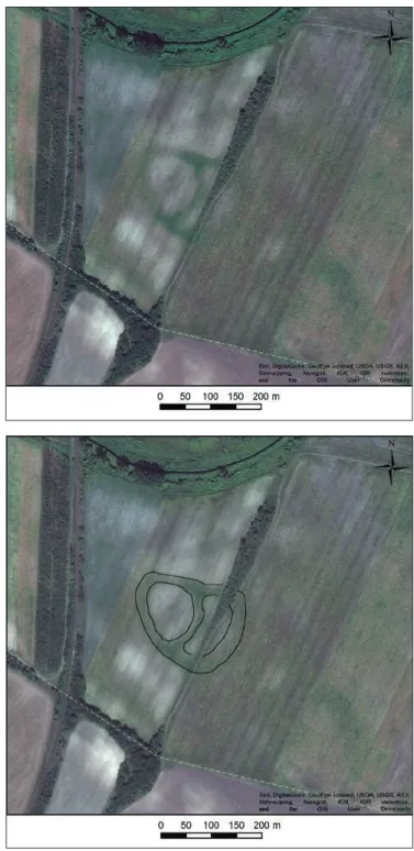
The first step in non-invasive and geoar- chaeological research consisted in a review of satellite imagery, in order to estimate the size of the site through reference to observ- able vegetation landmarks. Based on multi- ple-source satellite images, the dimensions of the fortified settlement were preliminar- ily determined, and the first observations on the site’s internal structure were made.
Among the many sources of satellite im-
agery, data obtained via the ESRI ArcGIS – World Imagery proved the most reliable and offered the highest resolution for that particular area.
The defensive settlement of Kakucs-Tur- ján was relatively easily discernible in said images thanks to the aforementioned veg- etation indicators. The oval, belt-like struc- tures show up as dark-green areas suggest- ing different soil substrate, which is reflected
44 Jakub Niebieszczański, Ákos pető, Gábor Serlegi...
in the quality of agricultural plant species (Fig. 1). The belt-like shape and the more viv- id colour of vegetation captured in the images indicates a more fertile substrate underneath, which may be interpreted as secondary infill, rich in organic compounds. Hence, tentative interpretations already indicated the presence of ditches surrounding the settlement and di- viding it internally (Fig. 2).
It followed from satellite imagery that the settlement was divided into the west- ern and the eastern part, which together formed an enclosed structure with a dis- tinctly elongated westward section. Ac- cording to imagery-based size estimations, the settlement measured 230 m along the
E-W axis and between 170 to 185 m along the N-S axis, with an overall surface of ca 3.2 ha. The circular western part is slightly larger than the eastern section. The sur- face, measured along the inner circum- ference of the ditches does not exceed 0.8 ha for the western part. The eastern part is oval in shape, elongated along the N-S axis, with a surface of 0.6 ha.
As can be seen, interpretation of sat- ellite imagery yielded a provisional as- sessment of the site’s potential structure, which in its turn served as basis for de- tailed geoarchaeological and non-invasive surveys by means of which a more precise picture would be obtained.
Fig. 1. Satellite imagery of the Kakucs-turján archaeological site.
Fig. 2. Satellite imagery of Kakucs-turján archaeological site with outlined vegetation indicators.
45
Geoarchaeological and non-invasive investigations of the site and its surroundings
1.3. Magnetometric prospection
The aim of the survey was to examine pre- viously identified site on the basis of aerial and satellite imagery. First of all, a detailed picture of the site’s inner structure had to be obtained. Considering the objective, a geo- physical survey appeared to be the most ap- propriate method. The Magneto MX® system developed by SENSYS GmbH (Berlin, Ger- many) was employed for that purpose; this is a complex multi-sensor magnetometer sys- tem consisting of several components, the chief of which are as follows:
– Vehicle-towed carrier system made by GRP and other non-magnetized mate- rials. The traction in the field was per- formed by a measurement optimized four-wheel drive Mitsubishi L200 type vehicle;
– Eight vertical fluxgate gradiometer sen- sors (type FGM650B). Each sensor con- tains two probes. The vertical base dis- tance between probes is 650 mm. The measurement range ± 10.000 nT and sensitivity 0.1 nT. The spacing of the sensors was 250 mm. Consequently, the interpolated point distance is 125 mm;
– RTK-capable GPS receiver pairs. The exact coordinates of the base station are very important for an accurate sur- vey. The latter were defined using offi- cial real-time network RTK correction services supplied by KGO FÖMI GNSS Service Centre (Hungary, Penc). The rover unit was equipped with Trimble R5 GPS and Trimble Sephyr antenna.
The base station correction signal was recorded at 1 pps, while using local co-
ordinate system HDS 1972 (Egységes Országos Vetületi Rendszer – EOV);
– Magneto MX® data acquisition unit.
The recording occurred with 20 Hz frequency, meaning that the spacing of the measurement points – as a function of the traction axial velocity – occurred between 80 to 100 mm. The navigation and sensor data capture control was performed through MonMx software on an Xplore iX104C5 tablet.
The sensor and GPS data combination as well as primary track-compensation was carried out with DLMGPS software. The generated 3-dimensional array of data was then subjected to further processing.
Magneto® ARCH 1.00-03, TerraSurvey- or 3.0.22.1, Golden Surfer 11.6.1159 and EHT2 software for data cleaning and fil- tering procedure.
Subsequently, GIS analysis of the out- put picture was conducted in ESRI ArcGIS 10.1. Magnetometric view was also con- verted to a pyramid-based raster in order to perform different representation proce- dures. Various ranges of color representa- tion made it possible to digitize magnetic anomalies into the shapefiles, facilitating spatial analyzes and better understanding of the distribution of anthropogenic ob- jects and structures in the magnetometric view.
The total area investigated was ca 11 ha, divided into the western and eastern part separated by a dirt road. The western part of the area comprised ca 5 ha, while the eastern one embraced a total surface of 6 ha.
1.4. Magnetometric view of the site
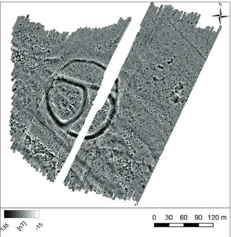
The results of magnetometric survey show the defensive settlement of Kakucs-Turján to be composed of three parts, divided by strips of land where higher magnetic susceptibility is observed (Fig. 3). Just as in satellite imagery (see section 1.2) the western and the eastern zones could be discerned. However, use of geophysical methods made it possible to distinguish yet another, northern part.
The overall output image demonstrates a distribution of magnetic anomalies ranging from -15 nT to 136 nT, excluding extreme values corresponding to contem- porary metal waste. Mean value of the magnetization gradient for the studied area was 0.08 nT, with standard deviation at 1.31. Consequently, value distribution in this case approached normal.
46 Jakub Niebieszczański, Ákos pető, Gábor Serlegi...
Fig. 3. Magnetometric view of the Kakucs- turján archaeological site. Initial maximum- minimum value representation.
Fig. 4. Density of anomalies with gradient intensity of 2 nt and surface exceeding 0.4 m2 at the Kakucs-turján site. Analysis based on kernel density estimation.
47
Geoarchaeological and non-invasive investigations of the site and its surroundings Considering spatial distribution of anom-
alies whose magnetization values set them apart from the background (ca 0 nT), it may be concluded that they were evidently concentrated where the settlement was ex- pected to be found. Kernel density analy- sis of the raster image, with 0.1 m cell size and 20 m sampling radius as input param- eters and results expressed in square me- ters indicated locations where the concen- tration of magnetic anomalies was highest (Fig. 4). Analysis of the spatial density of anomalies focused on those whose mag- netization gradient reached ca 2 nT and whose surface exceeded 0.4 m2. The largest cluster was detected in the western part, whereas the fewest number of anomalies was observed in the northern section. In the light of the analysis, the eastern part constituted an intermediate area, with a moderate density of anomalies. In addi- tion, a range of such anomalies and their clusters were found beyond the perimeter of the settlement. Given the current state of research, it remains unclear whether the structures represent traces of human activity or resulted from natural process- es, e.g. drainless hollows being filled with biogenic material.
The analysis of the magnetometric im- age focused primarily on the interpreta- tion and spatial examination of single-pole anomalies, while all dipole complexes were dismissed as they were presumed to indi- cate modern metal waste. The majority of anomalies which are interpreted as anthro- pogenic are characterized by an elevated magnetization gradient, ranging from 1 to 10 nT. Not infrequently, they are accom- panied by heterogeneous negative clusters, which nevertheless do not exceed -2 nT.
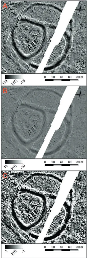
It should be noted that the spatial ele- ments were distinguished in the course of interpretation of the magnetomet- ric image based on three levels of raster representation (Fig. 5). The first showed the general range with minimum and maximum values of the magnetic gradi- ent (-15 nT to 136 nT). At that stage, all types of anomalies with extreme mag- netization values were identified, and locations of larger clusters of less promi- nent features were established (Fig. 5:a).
In the second level the value bracket was
narrowed down to -10 nT – 10 nT (Fig.
5:b). Within this range, it was possible to distinguish all anomalies which may have corresponded to anthropogenic infills, sec- ondarily burnt clay or wooden artefacts, as well as concentrations of ceramic items.
The last value range to be examined was
Fig. 5. three levels of resulting raster representation.
48 Jakub Niebieszczański, Ákos pető, Gábor Serlegi...
-1 nT – 1 nT, enabling detection of subtle differences in the magnetic field gradient in the area (Fig. 5:c). At this stage, attempts were made to identify the remnants of ear- lier elements of the natural environment, such as palaeohydrographic features.
The analysis of output rasters showing distinct representations revealed varied magnetic anomalies with respect to which anthropogenic origin was conjectured.
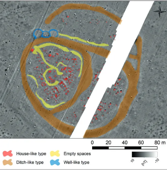
These anomalies were then divided into the following types (Fig. 6):
Fig. 6. Interpretation of magnetic anomalies at the Kakucs-turján archaeological site.
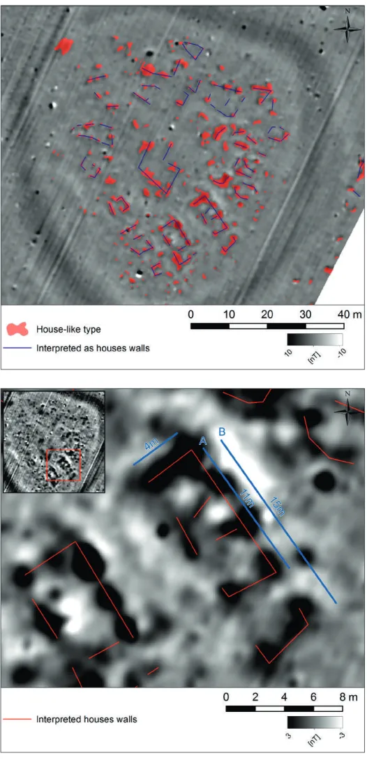
– house-like type of anomalies – groups of objects with increased magnetism whose layout suggested remnants of rectangular dwellings. In total, 370 such features were identified, with magneti- zation values ranging from 1 to 4 nT.
They were characterized by irregular outlines and highly variable dimen- sions, from several centimetres to over 3 metres. Their main concentration is found in the western part of the site, containing 251 structures of that type.
In the eastern section, as established in kernel density analysis, their number
is smaller (104 features), though it has to be noted that some of them may lie under the present-day embankment of a dirt road, where survey was not per- formed. Only 18 such features, the low- est quantity of all, were detected in the northern part;
The anomalies encountered in the western part proved to be the most in- teresting due to their arrangement, in most cases demonstrating rectangular outlines of housing structures. Sym- metrical lines traced along those fea- tures suggested that at least 9 variedly
49
Geoarchaeological and non-invasive investigations of the site and its surroundings sized huts could have existed in that part
of the site, constructed largely on a rect- angular plan. Apart from that a number (10) of other groups of anomalies were detected, but their arrangement does not resemble the shape of dwellings, or follows a house-like outline only to a minor extent. Features located in the southern section of the westward part of the settlement are the most representa- tive and bear the highest resemblance to building-type structures:
– ditch-like structures – as already ob- served in the beginning of this sec- tion and in section 1.2, the settlement is both surrounded and internally divided by a system of belt-like struc- tures whose conjectured provenance is that of an infill. Following interpreta- tion of the geophysical image, it turned out that magnetic properties of these
“belts” were higher compared with the geological background. This suggested the presence of an infill which differed considerably from the remaining sedi- ments of which the research area was composed. It was therefore presumed that a system of trenches or a ditch had existed there – the traces of which were being investigated at that point – en- closing the entire settlement and sepa- rating its individual sections. The width of these higher magnetization belts is not consistent, ranging from 5 up to 13 m. Nor is it clear whether they rep- resent a chronologically homogenous anomaly, since in certain locations, e.g.
in the central part which divides the northern section and the other two, the ditch network is interrupted, at least on the horizontal plane. Magnetization values fluctuate across the network, from 1 to 3nT, which may be indicative of the presence of organic matter.
– well-like structures – investigations in the north-western part of the site re- vealed three minor anomalies whose arrangement suggested circular struc- tures. In their case, the value of the magnetization gradient did not exceed 1.5 nT. Tangent to one another, they are situated within the ditch system, indi- cating potential cavities in the ground
and sedimentary fills which may be interpreted as wells or unidentified hy- drotechnical arrangement devised to collect underground and surface waters from the surrounding area (hydrogeo- logical depression?).
– open spaces – although a definite ma- jority of anomalies in the settlement display higher levels of magnetism, a negative gradient was encountered as well (from -0.01 to -15 nT). The main concentrations of such structures, which may attest to human activity, are located in the western and northern part. They are found along the inner edge of the ditches, adjoining the lat- ter and, in a sense dividing the elevated magnetization belts from house-like features. Furthermore, a number of those were detected in the central sec- tion of the western part, where they are likewise situated strip-like between clusters of dwellings. It should be ob- served that the structure of those strips is relatively homogenous and no other anomalies could be detected in the space that they cover (with the excep- tion of dipole ones, most likely cor- responding to contemporary waste).
Consequently, it was concluded that the structure in question may be associated with places whose utilization in the past had a distinct nature, i.e. was not related to construction activities. The decreased value of the magnetic gradi- ent may also be indicative of lithologi- cal differences, while homogeneity and clear-cut boundaries would suggest an- thropogenic provenance. This led to the assumption that these particular strips may represent erstwhile infrastructur- al component, such as paths, or areas outside economic use (a buffer zone in front of a line of fortifications in the form of ditches?). Taking into account the lay of those structures on the inner side of the ditches, it may equally well be supposed that they are remnants of embankments which, due to pressure, changed the structure and texture of the soil, but the absence of any mor- phological landmarks, i.e. a rise of the terrain, speaks against it.
50 Jakub Niebieszczański, Ákos pető, Gábor Serlegi...
1.5. Verification of magnetic features
Based on the output images from magne- tometric surveys, a selection of anoma- lies were chosen to undergo verification procedures. The composite methodology which was used for that purpose may be generally defined as geoarchaeological.
Field investigations and laboratory analy- ses encompassed excavation and probing, coring and conventional drillings, non-in- vasive prospection using GPR and electri- cal resistivity tomography, sedimentologi- cal analyses of samples from drillings and probings, including analyses of grain size distribution parameters, tests for organic matter, calcium carbonate, heavy metals or ancient phosphorus.
The first to be chosen for verification was an anomalous structure interpreted as remnants of a hut in the western part of the site (see section 1.5.1). The verifica- tion procedure consisted of conventional excavation and a range of laboratory anal- yses of sedimentological samples obtained during earthwork.
The belt-like structures interpreted as a system of trenches or ditches (see section 1.5.2) were the next type of features to un- dergo verification. In this case, assessments were made based on corings and lithologi- cal analysis of infill sediments (see Pető et al. Report on the geoarchaeological survey of Kakucs-Turján site, in this volume).
Drillings and laboratory analyses were also employed to verify the features inter- preted as wells or hydrogeological systems in the north-western part of the site (see section 1.5.3).
The structures interpreted as empty spaces or communication facilities were verified by means of drillings in the west- ern part of the settlement and partially in the archaeological trench excavated to ex- plore a structure conjectured to have been a hut (see section 1.5.4). Naturally, samples from drillings were then subjected to de- tailed laboratory analyses (see Pető et al.
Report on the geoarchaeological survey of Kakucs-Turján site, in this volume).
1.5.1. House-like type of anomalies The highest quantity of features interpreted as remnants of buildings was determined in the western part of the site. It was in that area that the course of the walls or outlines of huts could be reconstructed based on the arrangement of anomalies or groups of anomalies (Fig. 7). For that purpose, lines were traced symmetrically to anoma- lies with elevated magnetization gradient.
Consequently, potential number of build- ings could be assessed as well. It should be noted that the resulting picture does not have to reflect one time point of settlement but rather a cumulative outcome of numer- ous settlement phases. However, assuming that the magnetometric image can, to an extent, delineate the organization of the inhabited space, spatial reconstruction was performed, thanks to which the most rep- resentative and the best rendered feature could be chosen for verification procedures.
The pattern of anomalies suggests a con- centric arrangement of dwellings in the
eastward section of the settlement’s west- ern part. The longer axes of the features are oriented towards the central part, where an outline of a larger building was identified; significantly enough, the latter appears to have a square outline unlike the remaining, rectangular structures.
In most cases, the anomalies displayed higher magnetization gradient than their surroundings, which would indicate pres- ence of walls made of daub which was secondarily exposed to fire (or underwent primary firing at the moment of construc- tion).
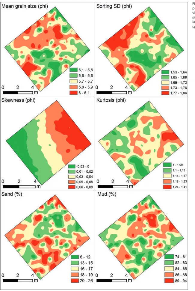
The feature which was most distinctly manifested in the magnetometric image was the conjectured remnant of a dwell- ing structure in the south-eastern section of the western part. (Fig. 8). The recorded layout of anomalies denoted the presence of remains of a hut, built on a rectangular plan and aligned with its longer side to the NW-SE axis. Based on the distribution of
51
Geoarchaeological and non-invasive investigations of the site and its surroundings
Fig. 8. Location of the house-like type of anomaly selected for verification.
Fig. 7. Distribution of the house-like type of anomalies and the inferred course of the walls.
52 Jakub Niebieszczański, Ákos pető, Gábor Serlegi...
anomalies interpreted as walls, the width of the hut was assessed at ca 4.5 m, where- as the lengthwise dimension could not be definitely determined. For the core pattern of anomalies (Fig. 8: line A) the length was 11.5 m, but if the two anomalies to the south-east were adopted as continuation of the hut, the length would reach almost 15 m (Fig. 8: line B).
The image of distribution of magnetic anomalies showed that the best preserved element was the north-eastern wall, as the structures with heigher magnetization were relatively uninterrupted there. The highest values of the gradient were record- ed in the conjectured north-eastern wall, reaching approximately +10 nT.
The hypothesis that the remnants served a domestic function was verified in the course of excavations. In the two trenches executed for that purpose, re- searchers found numerous remains of wall and floor covering which had been made of clay, i.e. daub, which was then second- arily burned. Still, it has to be considered that the analysed image may be a result of accumulation of structures from differ- ent periods and does not necessarily cor- respond to a specific settlement phase (see Jaeger et al. History of Bronze Age Habita- tion, in this volume).
The north-eastern wall was one of the elements where the geophysical im- age and the actual archaeological feature overlapped. The results of non-invasive prospection suggested that the structure is continuous, unlike the parallel south- western wall, which proved less discern- ible in the course of excavations. A pottery kiln was explored during these investiga- tions as well; it was located in the north- ward part of the hut and most likely con- stituted the source of the aforesaid high magnetic signal.
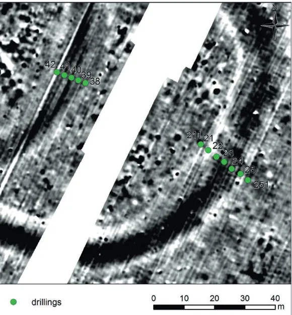
Planigraphy of excavations confirmed the hypothesis that the structure rendered in magnetometric image was a residen- tial one. In the course of the work, 248 samples were taken from trench 1, which subsequently underwent sedimentologi- cal (Folk, Ward 1957) and geochemical analyses. All samples (ca 0.5 l each) were obtained at a depth of around 50 cm be- low ground level, from locations marked
by a regular grid plotting (Fig. 9 and 10).
This layer falls within the K1 cultural layer identified during the pre-excavation geo- archaeological mapping of the site (see Pető et al. Report on the geoarchaeological survey of Kakucs-Turján site: Fig. 5; in this volume).
As regards representativeness of the level from which material was sampled for sediment studies, one has to bear in mind that two zones were being investigated.
The first of those, i.e. the western section of trench 1, contained negligible amounts of archaeological relics or traces of archi- tecture, whereas the second, encompass- ing the remaining area, yielded traces of several huts (see Harris Matrix; Jaeger et al. History of Bronze Age Habitation, in this volume). Therefore, when examining grain size of the sampled soil (anthropo- genic sediment), it was assumed that they represent two zones of settlement intensi- ty – an open part with a minor number of archaeological remains and a residential part, where settlement processes – in this case habitation – were significantly more intense. It should therefore be remem- bered that the results for the residential part given below illustrate the cumula- tive effect of sedentary processes rather than depict a selected stratigraphic level, which in this case would mean one build- ing stage of the hut.
Mean grain size (Fig. 9) in the trench ranges from 5.15 to 6.16 on the phi scale (0.031 to 0.016 mm), which corresponds to fine silts (Racinowski et al. 2001: 54). Spa- tial distribution of that parameter shows three main areas where particular mean grain sizes occur. The smallest diameters were observed in the central-northern and the south-western sections of the trench.
Between them, one sees evident concen- tration of lower grain size parameters, suggesting higher mean diameter (Fig. 9).
Presence of the finer fractions in the northern-central section is most likely due to considerable accumulation of ele- ments of residential architecture, such as the walls and the kiln which, having been made of fired clay, may have affected the results of the analysis.
The sorting of sediments in trench 1 may be defined as poor, as evidenced by
53
Geoarchaeological and non-invasive investigations of the site and its surroundings
Fig. 9. Basic parameters of grain size curve following sieve analysis and laser diffraction spectrometry.
54 Jakub Niebieszczański, Ákos pető, Gábor Serlegi...
the standard deviation (Fig. 9) of grain size distribution (with SD range of 1.48 – 1.92). It is within this range that one ob- serves spatial differentiation across the area. Also, it may readily be noticed that to a degree, it duplicates the horizontal dis- tribution of values in excavation planig- raphy. Poorer sorting is seen in the zone beyond the residential one, while better sorted sediments are found within the area of the huts. It needs to be noted that given the lithology of sediments (silt frac- tion) which are naturally deposited owing to aeolian processes, the extra-residential zone is characterized by poor sorting, which may attest to anthropogenic nature of deposition.
Skewness of grain size distribution ap- pears to reflect the differences between zones most lucidly (Fig. 9). The curve for the area associated with the hut layers is symmetrical or positively skewed, which indicates that sediments are rich in minor fractions or that they are stable. This may be correlated with the presence of weathered pieces of daub or other fragments of clay-based structural components. In the western and northern segments Sk drops to slightly negative (0 to -0.2) which suggests minor addition of phys- ically larger fractions.
Kurtosis for the entire trench 1 is within the range of 0.9 to 2 (Fig. 9), in other words it its lepto- or very leptokurtic. Parameters in such value range denote highly pulsed sedimentation environment. Considering the kurtosis for the aforesaid silty sedi- ments, one should presume anthropogenic deposition in unstable conditions (discrete deposition). Just as with skewness, the dis- tribution of values for that parameter is reflected in the planigraphy of the trench.
The north-western and the south-western parts are characterized by a less pulsative sedimentation environment compared with the area where numerous remains of buildings are found.
Another lithological parameter taken into consideration is mean grain size of sediments in the stratum from which samples were taken in trench 1. The re- sults demonstrate presence of the two main fractions observed, i.e. silt and sand fractions. Gravels and clays were found in marginal amounts (Fig. 9).
The percentage share of the sand frac- tion in trench 1 ranges from 5 to 27 %.
Spatial differentiation for that component shows disparities between the northern- central section and the remaining area un- der investigation (Fig. 9). There, the share of sand is the lowest, which is probably due to the largest concentration of daub elements, with finer fractions predominating. In the remainder of the trench, the percentage of sands is relatively even, from 18 to 27 %.
The silt fraction was dominant in all samples (from 75 to 98 %). Spatial distri- bution of the fraction is almost inversely proportional to sands. In the northern- central section, where remains of daub were identified, silt prevails content-wise in the entire sediment sample (Fig. 9).
Sediment samples were also tested for basic soil components, such as calcium carbonate (CaCO3; Dean 1974; Heiri et al.
2001) and organic matter (OM). The or- ganic matter share was calculated basing on the difference in weight between the dried sample and after the calcination for 6 hours in 550 ° C. The same method con- cerns the carbonates except the tempera- ture and time, which in this example was respectively 950 °C and 2 hours (Heiri et al. 2001).
Here, differences in spatial distribution are most easily perceptible with respect to CaCO3 content (Galas, Jaeger 2016: 67, Fig.
10). Its presence is negligible in samples from outside the residential part (1 – 2 %), but in the area where remnants of build- ings were inferred, the share of the com- pound increased several-fold, up to 12 %.
Organic matter content in the samples ranged from 5 to 13 %, with no palpable horizontal variability. This might be due to the shallow sampling and the impact of current soil-forming processes, or due to situation which developed in the course of prehistoric settlement processes.
Determination of ancient phosphorus content is an important element in the assessment of sediment anthropogeniza- tion. The samples from the archaeological trench were analysed in this matter us- ing the colometric method with the am- monium molybdate (Murphy, Riley 1962;
Spychalski et al. 2016). The amounts of the element fluctuated in the analysed samples
55
Geoarchaeological and non-invasive investigations of the site and its surroundings from 1,200 to over 4,400 ppm (Fig. 10),
but the spatial layout of its concentrations may be deemed surprising. In the section interpreted as non-inhabited, phosphorus values soar to 4,400 mg/kg, whereas in the dwelling zone it displays lower values in comparison. It may be noted that content exceeding 1,200 ppm already qualifies as high and suggests substantial degree of anthropogenization of the area.
Apart from phosphorus, sediments were evaluated for contamination with zinc, copper, iron, and manganese (Fig.
10). In most cases, the varied distribution of particular elements in the trench ap- pears to coincide with grain size analysis which demonstrated distinct lithological profiles of sediments in the residential sec- tion and the remaining area.
Zinc content was estimated between 31 and 48 ppm, with higher values being observed in the south-western section, be- yond the buildings (Fig. 10). Also, higher copper concentrations were detected in that location as well; the overall range for the latter element was 11 – 24 ppm.
Among the dwellings, the values for both copper and zinc dropped to the lowest re- corded limit. Such differences may be due to more intensive occupational/economic processes, such as use of bronze tools or casting of those outside one’s household or in its immediate vicinity.
The distribution of manganese in the trench resembles the dispersion pattern observed in the case zinc and copper (Fig.
10). The lowest detected values reached 219 ppm, being concentrated mostly in the residential section, whereas extreme- ly high content (419 ppm) was again ob- served in the south-eastern section. The accumulation of the element outside dwellings could be attributed to more ex- tensive effect of erosion processes than it was in the case of inside the dwellings.
In contrast, spatial distribution of iron proved to be altogether different. Its con- tent within the trench ranged from 11,000 to 16,500 ppm (Fig. 10). The highest con- centrations were detected where remnants interpreted as erstwhile daub walls were to be found. It should therefore be expected that the high iron levels in those locations reflect its original high content in the clay
deposits from which material for the walls was extracted.
To sum up the above sedimentologi- cal analyses, it has to be observed that all parameters of grain size distribution of- fer evidence of anthropogenic sedimenta- tion environment. In this respect, kurtosis and sorting are perhaps the most evident, Given that the dominant fraction in the entire studied section of the settlement is silt, grain size parameters speak against its deposition via aeolian processes. Poor sorting of sediments and leptokurtic dis- tribution of grain sizes must therefore be accounted for by human intervention.
High content of compounds and elements such as calcium carbonate, phosphorus, copper and zinc are additional markers of anthropogenic nature of deposition. In particular, ancient phosphorus in quanti- ties exceeding 1,200 ppm (up to as much as 4,400 ppm) suggests the existence set- tlement processes in the past.
Sedimentological analysis also made it possible to verify the spatial limits of a feature which was interpreted as a house based on the magnetometric image. The disparity in grain size parameters and geochemical composition of sediments between the anomaly in its contexts to the south west and north-west confirms litho- logical difference. The area of the anomaly is characterized by similarly anthropo- genic markers, whose values differ from what is observed outside the residential zone. It seems that a proportion of those indicators, such as the share of particular fractions or mean grain diameter might be due to the presence of numerous remains of residential architecture (daub, eroded vessel sherds or clay kiln and floors). In the area beyond the conjectured hut, the circumstances of sediment deposition appear to have been dissimilar, although they occurred as part of settlement pro- cesses. Lack of distinctive archaeological remains in the south-western and north- western section, low magnetization gradi- ent detected during geophysical prospec- tion, and simultaneously evident presence of markers of anthropogenic deposition, warrant the interpretation that it had been a path or area surrounding and belonging to a household. This concept will be eluci-
56 Jakub Niebieszczański, Ákos pető, Gábor Serlegi...
Fig. 10. Spatial variation in distribution of chemical elements in sediment samples.
57
Geoarchaeological and non-invasive investigations of the site and its surroundings dated in detail in the following sections of
the chapter (see section 1.5.4).
One should also draw attention to the varying spatial distribution of ancient phos- phorus. Its low content in the inhabited zone and high concentration beyond it are noth- ing short of striking. Perhaps this is a result of disposal of household waste outside its bounds or economic activity having taken place there? This is a likely alternative in view of higher values for zinc and copper in that very spot. However, the interpretation requires further studies into the functional aspects of the Kakucs-Turján settlement.
Summing up, both archaeological in- vestigations in the two trenches as well
sedimentological and geochemical analy- ses of obtained samples bear out the in- terpretations based on the magnetometric images as far as occurrence of dwelling remnants is concerned. By analogy, simi- lar findings should be expected when veri- fying other anomalies in that part of the settlement which display clearly rectan- gular outlines. Nevertheless caution is ad- vised if these particular findings were to be extrapolated to other sites surveyed us- ing the magnetometric method, as in each case verification methodology should be adjusted for existing geological, geomor- phological and archaeological conditions.
1.5.2. Ditch-like type of anomalies Magnetometric prospection demonstrat- ed the presence of elongated, oval struc- tures which surrounded the settlement and divided it into three main parts: the northern, the western and the eastern (Fig. 5, Fig. 6). The structures in question were preliminarily interpreted as a sys- tem of ditches. The total length of those belts, which can be distinguished thanks to higher magnetization gradient, is 750 m. The structures were divided in view of their possible function. Thus, the line of anomalies encircling the settlement would be referred to as the outer ditch system, while the inner system would consist of those stretches which separated individu- al parts of the settlement.
Average magnetization value for the anomalies was 2.5 nT, ranging from 1 nT and 3.5 nT. The width of the anomaly belt was between 6 and 15 m, with an average breadth of ca 10 m. The outer ditch sys- tem varied considerably in terms of width:
the anomalies to the north were much less broader than those to the south, west and east. In contrast, the inner ditches main- tained a fairly consistent width which did not exceed 11 m.
It should be noted that not all structures are connected in an uninterrupted fashion.
For instance, the anomalies are discontin- ued in the north-western part, where there is a gap between the northward belt and
the outermost belt to the west. A likewise situation is observed in the eastern part of the site where on the outer belt to the east the structures combine into a more com- plex arrangement in which chronological and stratigraphic variation and overlap may be expected. The issue of co-occur- rence of all elevated magnetization belts calls for further studies, in order to disen- tangle the mutual stratigraphic relations.
At this point however, the specific stages in which those structures developed can- not be reconstructed.
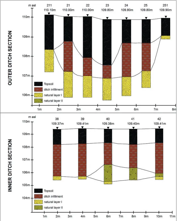
The interpretation according to which the anomalies in question were infills in the form of elongated ditches was verified through geoarchaeological corings per- formed in two test areas (Fig. 11) (Pető et al. 2016; see also Pető et al. Report on the geoarchaeological survey of Kakucs-Turján site, in this volume). The first, located in the eastern part, was intended as a means of lithological and stratigraphic explora- tion of the outer ring surrounding the settlement. The second targeted the in- ner system of ditches in the central part of the settlement. In both cases, a U-shaped form of the infill was determined, whose bottom reached the maximum depth of over 3 m below ground level, though not exceeding 3.5 m. (Fig. 12; for detailed stra- tigraphy see also Pető et al. Report on the geoarchaeological survey of Kakucs-Turján
58 Jakub Niebieszczański, Ákos pető, Gábor Serlegi...
site: Fig. 6 – 9; in this volume). Here, pre- dominant types of sedimentation were associated with aquatic (lacustrine) envi- ronment and biogenic accumulation. Pot- tery and other artefacts were detected as well. Taking into account the stable sedi- mentation environment in the ditch area, it should be expected that the relics origi- nated from the phase where the ditches were being used, as opposed to finding their way there post-depositionally in the course of backfilling episodes (Pető et al.
2015: 8; Pető et al. 2016: 234-235; for de- tailed description of the geoarchaeological observations see also Pető et al. Report on the geoarchaeological survey of Kakucs- Turján site, in this volume).
Stratigraphic data indicates that at least in a proportion of sediments, their lithol- ogy, structure and texture attests to stable sedimentation in stagnating water (Pető et
al. 2015: 8; Pető et al. 2016: 234-235). More- over, the corings acquired in the inner ditch system managed to capture a backfilling incident over which another cultural layer was found, which may signify that the con- jectured ditch ceased to be used (Pető et al.
2015: 8-9). As for the synthetic profile of the inner ditch, the incline of that concave form could not be determined. This may be due to the fact that it may have been con- structed with angular edges, which would be revealed if drilling resolution were high- er or if a probe trench were executed.
Thus, thanks to methods of field geology used for verification, it was possible to con- firm the predictions regarding the belt-like anomalies, which turned out to be concave structures filled with biogenic material that contributed to elevated magnetic signal.
Also, the stratigraphy in the profiles also showed that the ditch became fairly stably
Fig. 11. Location of profile drillings in the outer and inner ditch systems.
59
Geoarchaeological and non-invasive investigations of the site and its surroundings filled up in the environment of stagnant
water. Meanwhile, presence of artefacts in the obtained material was an indication that the structures were contemporary to habitation in the settlement. Nonetheless, it needs to be noted that the probings re- flect only topical stratigraphy and may not actually offer a reliable overall picture of sediment configuration. However, similar parameters of the magnetization gradient and the relatively well-outlined structures
in the horizontal renderings from non-in- vasive surveys suggest that other sections of the ditches would yield like results.
However, chrono-stratigraphic continuity in particular ditches remains an open is- sue. As observed at the outset, horizontal view of the anomalies shows gaps, there- fore at this stage of research it cannot be stated whether all structures seen in the magnetometric image were utilized in the same time periods.
Fig. 12. Simplified cross-sections of the outer and inner ditch structure.
Drilling numbers refer to Fig. 11 (after pető et al. 2015: Fig 7 and pető et al.
2016; see also pető et al. Report on the geoarchaeological survey of Kakucs- Turján site, in this volume).
60 Jakub Niebieszczański, Ákos pető, Gábor Serlegi...
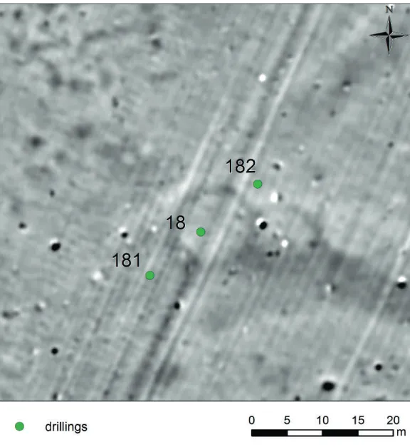
1.5.3. Well-like type of anomalies In the western part of the site where the ditch structures skirting the northern and the western zone connect, magnetomet- ric survey demonstrated 3 oval anomalies which displayed increased magnetization gradient (Fig. 5, Fig. 6). The perimeter of these features partially lies within the ditch system, while the features them- selves are latitudinally adjacent. All have a similar radius from 4.5 to 5.5 m. The structures were preliminarily interpreted as hollows filled with biogenic content which may have been remnants of wells or cistern-like features.
Again, shallow geoarchaeological cor- ings were performed as a verification measure (Pető et al. 2016; see also Pető et al. Report on the geoarchaeological sur- vey of Kakucs-Turján site, in this volume), whereby the procedures were planned in
such a way as to obtain a synthetic pro- file of the westernmost structures, as the latter was the most distinctly outlined of all three in the magnetometric image (Fig. 13). Three drillings were executed in total; the central one (Fig. 13: drilling 18) was situated within the structure, and the subsequent was made at a spot located to the east, where low anthropogenization of sediments was expected (Fig. 13: drilling 182). The final drilling (Fig. 13: drilling 181) was within the zone of the westward ditch; its aim was to document the rela- tionship of the conjectured well structure with the system of the extended depres- sions encircling the settlement (for de- tailed description of the geoarchaeological observations see Pető et al. Report on the geoarchaeological survey of Kakucs-Turján site, in this volume).
Fig. 13. Locations of profile drillings in the area of features interpreted as wells.
61
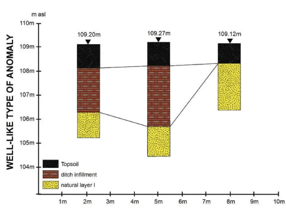
Geoarchaeological and non-invasive investigations of the site and its surroundings The corings provided an insight into
the subsurface structure in the central part of the anomaly (Fig. 13; see also Pető et al. Report on the geoarchaeological sur- vey of Kakucs-Turján site: Fig. 7; in this volume), which consisted of biogenic sediments with a substantial content of archaeological relics. Sedimentation in that cavity reached over 300 cm, while the stratigraphic texture assumed the form of microlamination at places (see Pető et al. Report on the geoarchaeological survey of Kakucs-Turján site: Fig. 8; in this vol- ume), which is indicative of aquatic de- position environment. The coring to the east showed a natural record of the site’s stratigraphy, with the natural background immediately underneath the ploughed soil horizon. As for the last coring, the se- quence of successive layers was similar as in the well, though the biogenic infill stra- tum was thicker (Fig. 14). This could be attributed to direct connection between the presumed well in drilling 18 with the ditch infill in drilling 181 (Fig. 13: 18 and 181). Given that chrono-stratigraphic data is lacking, the incline of the cavity’s slope and mutual relations of sediments in the
well and the ditch have not been captured in sufficiently high resolution, no conclu- sions can be made regarding potential concurrent functioning of both forms.
Questions concerning the function of that hollow within the ditch system or their general use in the settlement of Kakucs-Turján remain unresolved for the present. Considering the fact that sedi- ments filling that cavity are likely to have been deposited in the environment of – at least periodically - stagnant water, the pre- liminary interpretation which assumed it to have been a well is borne out to a de- gree. In the case of that particular anom- aly, it cannot be ruled out that it actually served as an artificial reservoir which col- lected ground- or underground water as a hydrogeological depression. However, one should consider the role of the two remain- ing features which display similar spatial parameters in the magnetometric image.
Perhaps the fact that there are as many as three may be accounted for by their var- ied chronological provenance and/or use, but this requires detailed stratigraphic or chrono-stratigraphic data to be obtained by means of coring and further sampling.
Fig. 14. Simplified cross-section of the well-like type of anomaly (after pető et al. 2015: Fig. 6 and pető et al. 2016; see also pető et al. Report on the geoarchaeological survey of Kakucs-Turján site, in this volume).
Drilling numbers refer to Fig. 13.
62 Jakub Niebieszczański, Ákos pető, Gábor Serlegi...
1.5.4. Open spaces
Apart from anomalies which undoubtedly owed to past human activity, the magne- tometric picture of the Kakucs-Turján site also demonstrates areas where no deviations from the neutral magnetic gradient were detected or minor negative response was ob- served (0 – -0.5 nT). Specifically, such areas were encountered at the inner boundary of the ditch system (Fig. 5, Fig. 6). Further such surfaces were identified in the centre of the western part of the settlement, where they surrounded an anomaly indicating remnants of walls (a central building?). Furthermore, elongated, strip-like structures characterized by neutral magnetic gradients extended from that location in various directions. While ab- sence of distinct anomalies beyond the set- tlement would have been taken as a matter of course, the structures in question were found between areas where the intensity of anoma- lies was quite considerable.
At the current stage of investigations it cannot be conclusively stated whether those elements are remnants of roads, paths, homestead premises, or other form of communication arrangements in the set- tlement. Still, since none were determined in the northern part (interpreted as an area dedicated to economic activity, specifically animal husbandry) and the eastern part where hut-like anomalies are very few or occur in much smaller quantities, such an interpretation is by all means viable.
The only means of verification one could employ at this point are the findings from archaeological and sedimentological investigations in trench 1, in the western part of the settlement. As discussed in section 1.5.1., no distinct archaeological features were established in the northern and western section of the trench, with
most residential structures found in the remaining sections. Nevertheless, sedi- mentological indicators for the apparently empty space showed poor grain sorting, pulsative sedimentation environment and presence of metals, phosphorus and other compounds (e.g. CaCO3), which attested to past human activity. Lack of more dis- cernible archaeological features, such as cuts, in that part of the trench may there- fore be indicative of another form of ex- ploitation of the area, especially in the light of grain size analysis and geochemi- cal characteristics of the soil. One of the possible explanations for these discrep- ancies in data is that the area, devoid of structures and immediately adjacent to a house, served as path for instance. Hav- ing adopted that explanation of the “emp- ty space” next to the preserved remnants of a dwelling, and extrapolating it to the entirety of the western part of the site, a map of a potential communication net- work was obtained, covering the residen- tial zone of the Kakucs-Turján settlement.
Obviously, these are tentative interpreta- tions which necessitate further studies.
Current work spans geological drill- ings and analyses of samples thus obtained so as to confront the above conception with the state of affairs in other sections of the western part of the settlement. The inves- tigations consist in analyzing 3 x 1 m plots, with evaluation of samples from locations which in the magnetometric image corre- spond to empty spaces, hut remnants and ditches. It is expected that the procedures will yield a comprehensive overview of sed- iment variation across those specific loca- tions and demonstrate their anthropogenic provenance, as in the case of trench 1.
63
Geoarchaeological and non-invasive investigations of the site and its surroundings
1.6. Environmental characteristics of Kakucs-Turján in the light of the magnetometric view, ERT and GPR prospection.
1.6.1. General outline of anomalies outside the settlement Thus far, the results of magnetometric
prospection were discussed only with re- gard to the interior of the Bronze Age for- tified settlement. As it follows from the analysis of density of occurrence of fea- tures with suspected anthropogenic ori- gin for the entire survey (Fig. 4), concen- trations of anomalies are also to be found outside the boundaries of the settlement, demarcated by the outer ring of ditches.
Archaeological excavations confirmed that they date back to prehistoric periods.
In many cases, those were cuts or aggre- gations of clay, which may be interpreted as floors, hearths or structures associated with oven remnants. It may thus be con- cluded that economic activity, even habi-
tation, were indeed practiced beyond the fortified settlement as well, though it was inside it that the largest concentration of such remains was expected to be found.
One of such locations is visible in the output magnetometric image to the west, as the survey encompassed the base of a minor incline, along which there was an accumula- tion of chemical compounds and minerals from higher (westward) terrain, producing an extended, linear anomaly with increased magnetization gradient (Fig. 15).
Apart from isolated anomalies, concen- trations of those or linear arrangements at the foot of sloping ground, prospection detected elongated strips aligned SE-NW where magnetization gradient was slightly
Fig. 15. Interpretation of the magnetometric image outside the fortified settlement.
64 Jakub Niebieszczański, Ákos pető, Gábor Serlegi...
increased (~ 1 nT) and which varied in width: from 1 m up to 10 m. In the middle of their course, they adjoin the settlement on the west, south and south-east (Fig. 15), occasionally connecting in horizontal view with the outer ditch system. The arrange- ment of those strips and their spatial interre- lationship resemble anastomosing pattern of palaeochannels which may have functioned in the past and supplied water to the ditch system. This might be inferred from the di- rect horizontal contiguity with the ditch in the south-eastern part of the settlement.
In this context, one cannot fail to draw at- tention yet again to the three features inter- preted as wells (see section 1.5.3), which in this case might have served as hydrogeologi- cal depression, forming a declivity of terrain that gathered water from a river or a stream.
However a different possible interpre- tation of those strips should be taken into
account; namely, they might constitute features of anthropogenic nature which, admittedly, are less apparent or only par- tially rendered in the magnetometric plan.
These may have been further systems of ditches linked to the settlement in one way or another, or may have functioned as such in a different cultural and chronological context. Particularly in the western and north-western parts of this area, the lines are parallel and reach substantial widths (ca 10 m), which could suggest remnants of deliberate human activity in the past.
The anomalies in question, owing to their complexity and the research pros- pects occasioned by their interpretation as a river system, prompted further verifi- cation work using non-invasive methods, i.e. electrical resistivity tomography and ground-penetrating radar survey.
1.6.2. Verification of magnetometric view by other non-invasive prospections
In order to verify the occurrence of sub-surface archaeological or natural fea- tures on the magnetometric plan, two lon- gitudinal resistivity profiles were obtained and a GPR scan was carried out (Fig. 16).
The first (section A-B on Fig. 16) was locat- ed in the SSW context of the site, partially crossing the ditch section in the north and reaching the colluvial border (Fig. 15 and Fig. 16) to the south (Fig. 17). In the centre,
Fig. 16. two sections (A-B and C-D) over the passes of higher susceptibility outside the settlement.
65
Geoarchaeological and non-invasive investigations of the site and its surroundings
Fig. 17. Ert of section A-B as marked in Fig. 16.
Fig. 18. Ert of section C-D as marked in Fig. 16.
the profile embraced the area of two linear structures interpreted as river channels or additional ditches. The second transect was performed parallel to the former (sec- tion C-D on Fig. 17), spanning the ditch in
the north, down to the colluvial border on the south. This section covered the minor ditch- or channel-like passes as well as one larger structure of the kind located fur- ther southwards.
1.6.3. Electrical resistivity tomography Electrical resistivity measurements were conducted by applying a direct electrical current into the ground using two current electrodes and measuring the voltage dif- ference at two potential electrodes. Given the voltage difference, the intensity of the direct current and the geometry of the four electrodes, the apparent resultant resistiv- ity can be determined. Having applied a
nonlinear, smoothness-constrained least- squares inversion technique in Res2DINV software, true resistivity could be calcu- lated.
The measurements were carried out us- ing a Geotom MK8E1000 high-resolution multi-electrode resistivity, consisting of a data acquisition unit, a computer and two single-shielded 25 cable-trees with