O R I G I N A L S T U D Y
AlpArray in Hungary: temporary and permanent seismological networks in the transition zone
between the Eastern Alps and the Pannonian basin
Zolta´n Gra´czer1 •Gyo¨ngyve´r Szanyi1•Istva´n Bonda´r1•
Csenge Czanik1•Tibor Czifra1•Erzse´bet Gy}ori1•Gyo¨rgy Hete´nyi1,2• Istva´n Kova´cs1•Irene Molinari3•Ba´lint Su¨le1•Eszter Sz}ucs1• Viktor Wesztergom1•Zolta´n We´ber1•AlpArray Working Group
Received: 29 September 2017 / Accepted: 14 February 2018 ÓThe Author(s) 2018
Abstract In the last few decades dense large-scale seismic networks showed their importance in studying the structure of the lithosphere and the upper mantle. The better understanding of the Apennines–Alps–Carpathian–Dinarides system is the main target of the AlpArray European international initiative in which more than 50 institutes are involved. The core of AlpArray is the AlpArray Seismic Network (AASN). With its 600 broadband seismic stations (280 of which are temporary) the AASN is, so far, the largest passive seismic experiment in Europe. The MTA CSFK Geodetic and Geophysical Insti- tute, as a Core Member of the AlpArray project, contributes to the AlpArray Seismic Network with its entire permanent network as well as with 11 temporary broadband seismic stations deployed in Western Hungary. Three additional station equipment were provided by the Swiss-AlpArray SINERGIA program. The average station distance together with the permanent stations is around 40 km in the area of interest. The temporary network has been installed between December 2015 and July 2016 and the planned operation period is 3 years. In this paper we describe the characteristics of the 29 per- manent and temporary stations, introducing not only the equipment, but the location, housing and geological setting, as well. We present median power spectral density curves in order to characterise the noise conditions at each station.
Keywords AlpArrayTemporary seismic networkHungarian National Seismological NetworkPannonian basinSeismic noise
& Zolta´n Gra´czer
graczer.zoltan@csfk.mta.hu
1 Geodetic and Geophysical Institute, Research Centre for Astronomy and Earth Sciences, Hungarian Academy of Sciences, Csatkai E. u. 6-8., Sopron 9400, Hungary
2 Institute of Earth Sciences, University of Lausanne, UNIL-Mouline Ge´opolis, 1015 Lausanne, Switzerland
3 Institute of Geophysics, Department of Earth Sciences, ETH Zu¨rich, 8092 Zurich, Switzerland https://doi.org/10.1007/s40328-018-0213-4
1 Introduction
AlpArray (http://www.alparray.ethz.ch) is a European collaborative project with the involvement of more than 50 institutes (universities, observatories, research institutes etc.) from 18 countries. It aims at studying the orogenic process and the structure of the crust and upper mantle in the greater Alpine region by using seismological and other geo- physical methods. Within AlpArray, the AlpArray Seismic Network (AlpArray Seismic Network2015) is collecting high quality seismic data which are the fundamental prereq- uisite to address the open questions on the Alpine orogeny (for details see Hete´nyi et al.
2018, submitted). The AlpArray Seismic Network (AASN) is, at present day, the largest large-scale passive seismic experiment in Europe. It officially began its operation on 1st of January 2016 and will run for at least 3 years. AlpArray in Hungary aims for a deeper understanding of the tectonics and geodynamics in the transition zone between the Eastern Alps and the Pannonian basin.
The Hungarian Academy of Sciences, Research Centre for Astronomy and Earth Sci- ences, Geodetic and Geophysical Institute (MTA CSFK GGI) contributes to the AlpArray Seismic Network with its entire permanent network as well as with 11 temporary broad- band seismic stations deployed in Western Hungary (Fig.1). Three additional station equipment were provided by the Swiss-AlpArray SINERGIA program for the stations A271A, A272A and A273A, which are co-managed with ETH Zurich. The average inter- station distance together with the permanent stations is around 40 km in the area of interest.
The temporary network has been installed between December 2015 and July 2016. The planned operation period is 3 years.
Fig. 1 Seismological stations in Hungary operated by the MTA CSFK GGI Ko¨vesligethy Rado´
Seismological Observatory. Red symbols: permanent, yellow symbols: temporary (AlpArray) stations of the Hungarian National Seismological Network. Triangle: Guralp CMG-3T 120 s seismometers, square:
Streckeisen STS-2 or STS-2.5 seismometers, diamond: Nanometrics Trillium Compact 120 s sensors.
Dashed line: 250 km distance contour around the Alps. (Color figure online)
In this paper we describe the research goals and objectives of the Hungarian partici- pation in the AlpArray project. We present the characteristics of the Hungarian National Seismological Network (which currently consists of the permanent stations and the AlpArray temporary stations), describe the seismic network requirements for the AASN and show the site selection criteria and process. In addition, we give a detailed description of the permanent and temporary stations introducing their equipment, locations, housings and geological settings. Finally, we describe the performance of the broadband stations, summarising the most important noise characteristics.
2 Research aims and objectives of the Hungarian AlpArray project
The Carpathian–Pannonian region (CPR) is an exceptional natural laboratory to understand the architecture and dynamics of the lithosphere. The reasons are mainly found in the complex geological processes which lead, in the last 30 Ma, to the formation of the Pannonian basin and surrounding mountain belts (i.e. Alps, Dinarides and Carpathians).
The main tectonic units are the Alcapa and Tisza-Dacia micro terranes which compose the basement of the region. The oceanic realms separating the main tectonic units (i.e. Pen- ninic, Magura, Vardar) were all closed by the convergence between Adria and the stable European Platform mainly before the Paleogene (Csontos and Vo¨ro¨s2004; Schmid et al.2008). Following the closure of these oceanic domains the Alcapa and Tisza-Dacia units gradually occupied the Carpathian Embayment from the late Oligocene until the late Miocene (11 Ma; Ka´zme´r and Kova´cs1985; Fodor et al.1999). The extrusion of these blocks overlapped with the intensive extension of the lithosphere in the central part of the CPR of which exact driving mechanism is still disputed (Huismans et al.2001; Horva´th et al.2006; Kova´cs et al.2012; Harangi et al.2015; Bala´zs et al.2016). Alcapa and Tisza- Dacia eventually collided with the stable European platform in the late Miocene. This resulted in the disappearance of the Carpathian Embayment marking the onset of transition into the inversional stage of the CPR which started 5 Ma ago and still shapes the area.
The main phase of the extension in the Miocene was accompanied by large scale calc- alkaline volcanism in the vicinity of major tectonic zones (e.g. Mid-Hungarian Zone;
Eastern Carpathian; Szabo´ et al.1992; Harangi et al.2007; Kova´cs and Szabo´2008); while alkaline basaltic volcanism occurred in the Plio-Pleistocene during the tectonic inversion stage (Embey-Isztin et al.1993; Harangi et al.2015) and produced sporadic volcanic fields in the CPR.
The AlpArray network in Hungary covers the transition from the Eastern Alps to the Pannonian Basin: a geologically particularly interesting area to understand more accurately the extrusion, extension of the main tectonic units and the effects of the subsequent tectonic inversion. With the new AASN data we will be able to outline with more detail the structure of the lithospheric units exploiting the horizontal and vertical variations in the velocity of seismic waves, anisotropy of seismic wave propagation and focal mechanism of earthquakes occurring in the area (e.g. body and surface wave tomography, receiver functions, SKS splitting etc.). The major open or disputed scientific questions which are planned to be addressed by the project are:
1. Tracing and identifying more accurately the remnants of subducted slabs beneath the CPR. Previous studies depicted a negative velocity anomaly extending towards the Alcapa unit from below the Eastern Alps at a depth of 300 km (Ren et al. 2012;
Qorbani et al. 2015). The subduction ‘graveyard’ beneath the basin could also be imaged more accurately (Hete´nyi et al.2009).
2. Understanding whether the extrusion of the major tectonic units happened at the scale of the upper crust or in the entire lithosphere (e.g. Qorbani et al.2016). Focusing on the distribution of major vertical seismic impedance contrasts in the lithosphere could facilitate answering this question and extends earlier studies with limited coverage (e.g. Hete´nyi and Bus2007; Hete´nyi et al.2015).
3. It is also debated whether the major tectonic boundaries (e.g. Mid-Hungarian Zone, Ra´ba line etc.) are only present in the crust or could be traced down all the way to the asthenosphere, cross-cutting the entire continental lithospheric mantle (c.f. Tari et al.
1999; Horva´th et al.2015; Kova´cs et al.2007,2012). This challenging topic could be resolved if horizontal heterogeneities are mapped in the lithosphere as tectonic units are likely expected to show coherent images if separated by deep fault zones (i.e. the tectonic lines on the surface are only the surface manifestation of deep faults separating entire lithospheric blocks with more or less homogeneous seismic properties). If the pattern of horizontal heterogeneities is independent of the major tectonic faults, this may imply that the crust and the lithospheric mantle are decoupled or highly heterogeneous.
4. Foliation and lineation developed in upper mantle rocks (produced by olivine the most voluminous constituent of the upper mantle) could indicate the direction of minimum stress (extensional half space). Seismic anisotropy (SKS splitting, and those obtained from ambient noise tomography at long periods) originating mainly from the lithospheric mantle and the asthenosphere can be used as a proxy for outlining the prevailing stress field under the area (Silver1996; Vauchez et al.2012). The direction of seismic anisotropy could be confused by frozen-in, inherited anisotropies from previous tectonic episodes. Namely, present seismic anisotropies could reflect mainly the present stress field (tectonic inversion), but directions could also bear some imprints of the prior extensional episode or local effects.
5. Studying the focal mechanisms of earthquakes can contribute to reveal whether the crust, lithospheric mantle and asthenosphere deform uniformly or heterogeneously both in horizontal and vertical sense? The focal mechanism of earthquakes occurring in Hungary could outline the present day stress field in the upper and middle crust where hypocenters are usually located (We´ber and Su¨le2014; We´ber2016a,b). These directions can be compared to those of seismic anisotropy from the crust or the underlying upper mantle. By assessing the style and rate of crustal deformation using GPS and earthquake data (e.g. Bus et al.2009) and computing the seismic/geodetic strain rate ratio the deformation mechanism, rheology and tectonic style of the CPR can be studied. Consequently the kinematics of lithosphere deformation at the transition between the Eastern Alps and the Pannonian basin could be constrained more accurately.
3 The Hungarian National Seismological Network
The history of the Hungarian National Seismological Network (HNSN) dates back to 1902, when the first Omori-Bosch seismographs were installed in Budapest and O´ gyalla (now Hurbanovo, Slovakia) (Varga2016). The network was gradually extended up to 10 stations until 1914, however it could not avoid the devastating effect of both World Wars. Later the
predecessors of the MTA CSFK GGI Ko¨vesligethy Rado´ Seismological Observatory (KRSZO) installed and dismantled several stations during the twentieth century, but only a few stations were operating simultaneously. The number of the HNSN stations exceeded ten for the first time only in 2013. The digital registration started in 1992 in Hungary using a STS-2 seismometer at Piszke´stet}o in cooperation with the German GeoForschungsZentrum. The first digital permanent station operated exclusively by the KRSZO (at that time known as MTA GGKI Seismological Observatory) was installed in Sopron in 2004.
In September 2017, the HNSN (doi:10.14470/UH028726) consists of 29 online broadband stations, 15 of them are permanent stations supplemented by 14 temporary stations deployed in the framework of the AlpArray project (Fig.1). All the stations are operated by the KRSZO. Three stations from the 14 temporary stations are co-operated with ETH Zurich as their equipment were funded by the Swiss-AlpArray SINERGIA program.
Although the permanent part of the network spans the entire territory of Hungary, the geometry is driven by the topography. As a significant part of the country is covered by sediments and the basin depth exceeds even 7 km in some places, most of the stations are concentrated in hilly/mountain regions to avoid high noise levels that usually characterise sedimentary basins.
The main purpose of the network is the continuous monitoring of the seismicity of Hungary and to provide high quality data for the seismological and geodynamic scientific research. However, in order to meet social demands, in case of a felt earthquake the protocol followed by the KRSZO include the notification to official bodies, such as the National Directorate General for Disaster Management and the official Hungarian news agency (MTI). Information about the latest events are posted on the homepage of the Observatory (http://www.seismology.hu), Facebook page (http://www.facebook.com/
krszo) and Twitter account (http://www.twitter.com/szeizmologia). In addition, focal parameters and phase readings of the detected local events and macroseismic data of the felt Hungarian earthquakes are published yearly in the Hungarian National Seismological Bulletin.
All data are acquired in real-time by the HNSN data centre located in the building of the KRSZO in Budapest. The permanent part of the HNSN follows an open data policy:
seismic waveform data are available in real time without any restrictions from the Euro- pean Integrated Data Archive (EIDA).
4 The AlpArray network in Hungary
The scientific objectives set by the AlpArray project can only be achieved if the temporary and permanent stations conform to the quality requirements described in the AlpArray Technical Strategy document (Brisbourne et al. 2013). These standards include the site selection process; station equipment and settings; deployment procedure, data communi- cation, formats and access; and the noise characteristics.
The naming of the temporary stations was strictly regulated. All the AASN temporary stations have the FDSN network code Z3. The station codes have five characters. The first one is a compulsory A. The middle characters form a three digit number (the range between 260 and 279 has been assigned to Hungary). The last character initially is an A,
but it must be replaced by B, C, ... if the station location is changed by a distance more than 20 m.
The scouting work for the Hungarian AASN temporary stations began in June 2015.
There were 14 temporary station locations planned for the western part of Hungary by the AlpArray project. To form a uniformly distributed network, stations had to be deployed at a site with less than 6 km distance from the preliminary location points, preferably within 3 km distance.
All the Hungarian station equipment and settings comply to the technical regulations.
Three component broadband sensors with flat velocity-response in the frequency domain from 20 Hz to at least 0.03 Hz (30 s), preferably down to 0.008 Hz (120 s) and digitisers with[130 dB dynamic range between 0.1 Hz and 10 Hz are required, together with continuous GPS timing and 100 sps or higher sampling rate. Data have to be provided in miniSEED format to EIDA and the state of health of the network should be continuously monitored in order to provide reliable data availability and quality for the AlpArray project.
According to the AASN requirements the mean or median PSD noise levels for rock or competent soil sites must be 20 dB lower than the New High Noise Model (NHNM, Peterson1993) on all the three components for the 1–10 Hz frequency range. For periods between 20 and 100 s the horizontal and vertical noise must be lower than the NHNM level by 10 and 20 dB, respectively. In the case of soft soil or basin sites the noise levels must be below the NHNM for all components for the above frequency ranges.
When selecting new station locations several conflicting aspects have to be considered.
We searched for locations characterized by low amplitude cultural noise with main power grid and continuous internet connection (wired or mobile). In addition, our optimal site had to have high level of security to reduce the risk of damages and accessibility in all seasons.
Based on these criteria we preferred unused cellars, independent vaults, rarely used cot- tages and funeral homes or chapels at cemeteries. Before each station installation we performed several noise level measurements in the target area in order to find the best possible site. Selection of the final location was always based on the comparison of the power spectral density plots computed at each candidate site by the method of McNamara and Buland (2004). Although it was only recommended but not prescribed, we have realized real-time data transmission at all stations.
By the beginning of March 2016 all stations but A270A were deployed. This last station was installed in July 2016. Considering the final location of the 14 stations (Fig.1), eight stations have a distance less than 3 km from the preliminary location, while the other stations’ distance is between 3 and 5.8 km. The average inter-station distance for the Hungarian part of the AASN area is around 38 km.
5 Equipment and station design
The HNSN consists of broadband online stations (for locations of the stations see Fig.1).
Two types of equipment are used: (1) Guralp CMG-3T 120 s seismometers with Guralp DM24S3EAM (or CMG-DAS) data acquisition units and (2) Streckeisen STS-2 or STS-2.5 seismometers with EarthData PS6 24-bit digitisers or Guralp DM24S3EAM data acqui- sition units. The temporary AlpArray stations are exclusively equipped with Guralp CMG- 3T 120 s sensors and Guralp DM24S3EAM digitisers. The three station equipment
provided by ETH Zurich use Nanometrics Trillium Compact 120 s sensors and Nano- metrics Taurus 3-channel 24-bit digitisers.
Stations are usually placed in stand-alone cellars, in rarely used buildings or inside vaults. Several forms of ground–sensor coupling are used. In case of the permanent stations more than half of them are installed on a concrete plinth. This is usually a concrete cube with a side length varying between 0.5 m and 1 m. Deploying the sensor on concrete or tiled floor is also common. Occasionally the equipment is placed on a granite slab or directly on rock. The granite slab is usually 3333 cm wide and 2 cm thick. As the AlpArray stations are temporary, a concrete plinth was made only at two of them. In most cases the sensors are installed on the concrete or tiled floor and some are placed on granite slabs. A typical station configuration can be seen in Fig.2.
For sensor orientation magnetic north was measured with a compass without correction for magnetic declination. In every HNSN station thermal insulation of the sensor is ensured
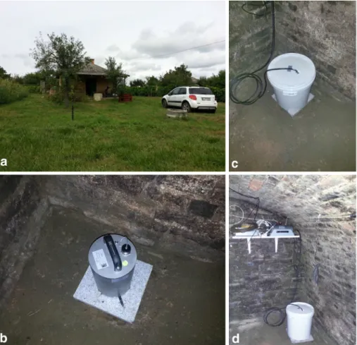
Fig. 2 A typical station configuration for the AlpArray project. aThe selected one-storey building for station A267A.bSensor after levelling and orientation with magnetic compass. North direction is marked on the granite slab.cFor thermal insulation the sensor is covered with a pail filled with polystyrene packing foam peanuts. d The installed station. GPS antenna is mounted through the vent chimney. (Color figure online)
by a pail filled with polystyrene packing foam peanuts. Each station is connected to the power grid system. Batteries provide 12 V DC required for the operation of the instru- ments, and at the same time they ensure continuous data recording in case of power outages. Real-time data access is realized through wired or 3G mobile network connection.
All the stations use GPS timing.
Between 20th March and 20th April 2017 we measured the orientation of the sensors of permanent and temporary stations using an iXblue Quadrans fiber-optic gyrocompass (kindly provided by the Institute of Geophysics, Czech Academy of Sciences). The ori- entation values can be seen in Tables1and2. The seismometers of the stations LTVH and PSZ were not on their plinth during the measurement period, so in these cases only the north line was drawn and during their relocations the sensors were oriented according to these lines. Therefore the 0.0°values for these stations in Table1are valid only for the post-measurement period. In the case of A265A the owner of the station’s building was not available, thus we could not perform the measurement. This lack of data is indicated byNA in Table2. The measured orientations range between-14.6°and 18.9°, the deviation from the north was smaller than 6°for 14 stations from the measured 26. It is important to note that the sensors were not reoriented after the gyrocompass measurements, but the orien- tation information has been added to the stations’ metadata.
6 Data acquisition
The real-time data are acquired in miniSEED format by the KRSZO using the SeisComp3 software package (http://www.seiscomp3.org). The sampling frequency is set to 100 Hz.
The collected data of the HNSN permanent stations are archived at the GEOFON EIDA node, while the ORFEUS EIDA node stores the data of the Hungarian AlpArray temporary stations. The waveform data from the permanent stations are openly available through EIDA, however at the present time the data from the AlpArray temporary stations are restricted to the Core Group members of the AlpArray project. The details of the data access policy can be found at the AlpArray website (http://www.alparray.ethz.ch/seismic_
network/backbone/data-access/).
7 Site characteristics
In this section we introduce each station, describing the location, housing type, site geology and seismic noise characteristics. Station names, locations, coordinates, equipment, beginning of operation, orientation of sensors and the type of geological environment are summarised in Tables1and2.
Geological descriptions are based on the Pre-Cenozoic geological map of Hungary by Haas et al. (2010) and the Geological map of Hungary by Gyalog (2013) available at the http://map.mbfsz.gov.huwebsite.
The noise characteristics of the stations are discussed based on the results of power spectral density (PSD) computations whose details are presented in Sect.8.
Table1MainparametersofthepermanentstationsoftheHungarianNationalSeismologicalNetwork StationcodeLocationLat.(°N)Lon.(°E)Elev.(m)StartofoperationSensoraAcquisitionb/(°)Geol. ABAHAbau´jke
´r
48.296121.23971952016.10.12.STS-2.5CMG-DM24S3358.5hr AMBHAmbro´zfalva46.350120.7258912013.02.12.CMG-3TCMG-DAS10.9us BEHEBecsehely46.470316.77553032005.07.03.STS-2PS6-2410.9us BSZHBesenyszo¨g47.299620.2670822013.09.11.CMG-3TCMG-DM24S313.9us BUDBudapest47.483119.02011962004.11.07.STS-2PS6-244.7hr CSKKCso
´kak }o47.363118.26063202016.01.29.CMG-3TCMG-DM24S311.2hr EGYHEgyha
´zas kesz}o47.416217.33171262015.07.24.CMG-3TCMG-DM24S318.9us KOVHK}ova´go´to¨tto¨s46.088318.09992702015.02.24.STS-2.5PS6-247.5hr LTVHLe´tave
´rtes 47.384921.90071122012.05.30.CMG-3TCMG-DM24S30.0us MORHMo´ra´gy46.215018.64361322012.03.02.STS-2CMG-DM24S34.3hr MPLHMagyarpola
´ny
47.171217.53483372013.10.08.STS-2.5PS6-24345.4hr PSZPiszke´stet}o47.918219.89349371995.01.01.*STS-2PS6-240.0hr SOPSopron47.680716.55672602004.04.14.STS-2PS6-24357.1hr TIHTihany46.900117.88771842012.11.09.CMG-3TCMG-DM24S3357.2hr TRPATarpa48.130422.53911132006.11.01.STS-2CMG-DM24S34.2hr TheStartofoperationcolumnshowsthedatewhenthestationstartedtoworkasadigitalbroadbandstation./isthemeasuredazimuthofthesensororientationrelativeto North.Geol.isthetypeofthesite’sgeologicalenvironment.hrhardrock,usunconsolidatedsediment/sedimentarybasin *AlthoughthedigitalrecordingatPSZstationstartedin1992,thefirstavailabledataarefrom1995.01.01 aSensors:CMG-3T–GuralpCMG-3T120sbroadbandseismometer,STS-2andSTS-2.5–Streckeisenbroadbandseismometers bDataacquisitionunits:CMG-DM24S3–GuralpCMG-DM24S3EAMdataacquisitionsystem,CMG-DAS–GuralpCMG-DASdataacquisitionsystem,PS6-24–EarthData24 bitdigitiser
Table2MainparametersofthetemporarystationsoftheHungarianAlpArrayNetwork StationcodeLocationLat.(°N)Lon.(°E)Elev.(m)StartofoperationSensoraAcquisitionb/(°)Geol. A260AVassura´ny47.283416.70562432016.01.26.CMG-3TCMG-DM24S318.1us A261AO´hı´d 46.952017.14861712016.01.26.CMG-3TCMG-DM24S35.4us A262ASzaknye´r
46.864216.52762402016.01.27.CMG-3TCMG-DM24S3354.0us A263AHolla´d46.640817.31491652015.12.15.CMG-3TCMG-DM24S33.2us A264ATarany46.159717.28971432016.01.27.CMG-3TCMG-DM24S310.5us A265AKaposfu¨red46.424517.79541512015.12.15.CMG-3TCMG-DM24S3NAus A266AGyulaj46.525618.26472192015.12.03.CMG-3TCMG-DM24S34.5us A267AKa´loz46.946318.48201162015.12.03.CMG-3TCMG-DM24S35.9us A268ARe´de
47.431317.92382012016.02.02.CMG-3TCMG-DM24S3359.5hr A269ABaj47.638618.38241952015.12.09.CMG-3TCMG-DM24S38.8hr A270ASzokolya47.845219.01861522016.07.06.CMG-3TCMG-DM24S3356.7hr A271AIva´ncsa47.154718.83411652016.01.13.TrilliumTaurus16.4us A272ABo¨lcske46.744418.96541702016.01.13.TrilliumTaurus4.4us A273AMaro
´csa
45.916317.81611002016.03.02.TrilliumTaurus358.5us TheStartofoperationcolumnshowsthedatewhenthestationstartedtoworkasadigitalbroadbandstation./isthemeasuredazimuthofthesensororientationrelativeto North.Geol.isthetypeofthesite’sgeologicalenvironment.hrhardrock,usunconsolidatedsediment/sedimentarybasin aSensors:CMG-3T–GuralpCMG-3T120sbroadbandseismometer,Trillium–NanometricsTrilliumCompact120ssensor bDataacquisitionunits:CMG-DM24S3–GuralpCMG-DM24S3EAMdataacquisitionsystem,Taurus–NanometricsTaurus3-channel24-bitdigitiser
7.1 Site characteristics of the permanent stations 7.1.1 ABAH–Abau´jke´r
Station ABAH is located in the administrative area of the village Abau´jke´r, at the eastern part of the North Hungarian Range (Zemple´n Mountains). The pre-Cenozoic basement is at 2 km depth, on the surface Middle Miocene pyroxene andesite and its pyroclastics can be found. The station has been deployed in a cellar which belongs to a hotel in the middle of a forest, approximately 1 km from the nearest settlement. The cellar is carved into a cliff, where the sensor was installed directly on rock. There is a low traffic local road 40 m from the station and the distance to the hotel’s main building is 30 m. The median power spectral density curves in the short and long period ranges are well below the-20 dB noise level for both the vertical and horizontal components, except for the horizontal components at long periods where they run above the-10 dB curve.
7.1.2 AMBH–Ambro´zfalva
Ambro´zfalva is a village in the Great Hungarian Plain, close to the Hungarian–Romanian border in south Hungary, where more than 2 km thick sediments cover the basement and Upper-Pleistocene loess is on the surface. The station was deployed at the funeral home in the cemetery located at the edge of the village. The sensor is placed on the concrete floor.
There is a low traffic local road around 40 m from the station and the distance to the nearest buildings is larger than 100 m. At short periods the vertical and horizontal noise is high due to the sedimentary environment, but the PSD curves stay below the NHNM. In the long period range the median PSD curves for the horizontal components run along the NHNM, the vertical noise curve lies in the middle of the NLNM–NHNM range, below the-20 dB level.
7.1.3 BEHE–Becsehely
Station BEHE is located at a hilltop 2 km from the residential area of Becsehely. The basement is approximately at 4.5 km depth and the surface is covered by Upper Pleistocene eolian brown loess. The equipment is placed in a one-storey adobe building in a sparsely built area with fruit gardens and vineyards. The floor is made of concrete, the sensor was installed directly on it. The possible noise sources are a 20 m high antenna and a very low traffic local road, both roughly in 20 m radius of the sensor. The short period vertical and horizontal noise is high, the median PSD curves run-10 dB below the NHNM level. In the long period range the vertical noise is satisfactory, while the horizontal median PSD curve is well above the NHNM. This extreme horizontal noise can be probably explained by the presence of the antenna.
7.1.4 BSZH–Besenyszo¨g
Besenyszo¨g lies on a 4 km thick sedimentary cover sequence in the northern central part of the Great Hungarian Plain, where Holocene fluvial silt and clay are observed on the surface. Station BSZH has been deployed in the basement of a chapel at the village cemetery inside the residential area. The equipment was placed on a concrete plinth. The distance of the nearby dwelling houses is larger than 50 m. The short period vertical and
horizontal noise is very high due to the young, unconsolidated sediments and the sur- rounding residential area, the median PSD curves run along the NHNM. In the long period range the median PSD curves for the horizontal components are above the NHNM by around 10 dB. This high noise level is possibly due to the ground tilt caused by the tower of the chapel. The vertical noise curve runs much lower, it is close to the-20 dB level.
7.1.5 BUD–Budapest
Station BUD is located in the city of Budapest, near the building of the KRSZO. The sensor is placed on a concrete plinth in an underground tunnel carved into Upper Triassic dolomite. The room hosting the seismometer is approximately 20 m beneath the surface.
The territory belongs to a nature reserve, the nearest residential buildings are more than 60 m away from the station. The distance of the closest street is around 70 m and there is a very high traffic road at 400 m and a busy railway line at 600 m from the station. For the short periods the vertical and horizontal PSD curves are below the-10 dB level. At the long period range, the vertical median PSD curve is between the-20 and-10 dB levels, while the curves belonging to the horizontal components are below the-20 dB level.
7.1.6 CSKK–Cso´kak}o
Station CSKK is located in the Ve´rtes Mountains. The sensor is deployed in the basement of a two-storey cottage which is built upon Upper Triassic limestone. The building can be found at the remote peripheral part of the village of Cso´kak}o. Potential noise sources are a nearby low traffic road, a heavy traffic secondary road 2.8 km far away and a large forested area towards NE of the station. Until January 2016 CSKK had been working as a short period station, since then a broadband sensor has been operating which is placed on a granite slab. The noise level is satisfactory both on the vertical and horizontal components regarding the short period range, and on the vertical component in the case of long periods.
Above 20 s, the horizontal median PSD curves approach from below the NHNM.
7.1.7 EGYH–Egyha´zaskesz}o
Egyha´zaskesz}o is a village at the southern part of the Little Hungarian Plain. It is situated approximately 2.2 km from the Ra´ba River, the thickness of the sedimentary cover exceeds 2 km. The area is flat and Upper Pleistocene gravel is on the surface. The station is installed at the eastern edge of the village, in the basement of a nursery school. The sensor is placed on a concrete floor. The short period vertical and horizontal noise is relatively high, but the median PSD curves lie below the-10 dB level. In the long period range the horizontal noise median PSD curves run close, but below the NHNM, the vertical noise curve is well below the-20 dB level.
7.1.8 KOVH–K}ova´go´to¨tto¨s
K}ova´go´to¨tto¨s is a small village in the southern part of the Mecsek Mountains. Station KOVH is located in the centre of the residential area beneath the local council building in a cellar which is carved into Upper Permian–Lower Triassic sandstone. The sensor is placed on a concrete plinth. Despite being in the centre of the village, the nearby traffic is light, however there is a very high traffic primary road in 3.3 km distance that might influence
the noise level. The median PSD level is rather close to the low noise model both on the vertical and horizontal components regarding the short period range, and on the vertical component for long periods. Above 20 s, the horizontal median PSD curves approach from below the-10 dB level.
7.1.9 LTVH–Le´tave´rtes
Station LTVH is installed in the cemetery of Le´tave´rtes, a village in eastern Hungary, close to the Hungarian-Romanian border. The settlement lies on 3.5 km thick sediments with Upper Pleistocene loess on the surface. The cemetery is located at the edge of the village, the distance to the nearby residential houses is larger than 200 m. The station has been deployed in a vault, the sensor was placed on a concrete plinth. LTVH can be described by high noise levels (the maximum is somewhat below the NHNM curve) both on the vertical and horizontal components, the only exception is the long period range on the vertical component where the median PSD curve is below the-20 dB level. The short period noise characteristics at LTVH are very similar to that of the other two stations (AMBH, BSZH) deployed on soft sediments in the territory of the Great Hungarian Plain.
7.1.10 MORH–Mo´ra´gy
Mo´ra´gy is a village in the Mecsek Mountains. The MORH station is deployed in its residential area in a cellar which is carved into a cliff consisting of Paleozoic granite. The sensor is placed on a concrete plinth. The site is surrounded by only a few houses (their distance is larger than 70 m) and the local area is characterized by little traffic, however there is a highway at 4.4 km distance. To the east of the station a forest can be found.
MORH can be considered as the best seismic station in Hungary, the noise level is sat- isfactory at all periods. In the long period range the vertical component noise is very low, its median PSD curve runs along the NLNM exceeding it by only around 5 dB.
7.1.11 MPLH–Magyarpola´ny
The village of Magyarpola´ny is located at the northern margin of the Transdanubian Central Range, where Middle Eocene limestones outcrop. The MPLH station is situated outside the residential area (its distance[400 m), on a hillside where traffic is negligible.
The closest primary road lies at a distance of 3.6 km. A two-storey building hosts the equipment, where the sensor is placed on the concrete floor of the ground level. The noise level is satisfactory on the vertical and horizontal components in the short period range. At long periods the vertical noise is of low level, the horizontal component curves run below the NHNM level by 5–10 dB.
7.1.12 PSZ–Piszke´stet}o
PSZ was the first digital seismological station in Hungary. It is located in the Ma´tra Mountains (North Hungarian Range) at 940 m altitude where Middle Miocene pyroxene andesite is on the surface. The equipment is placed in the middle of a forest in the basement of a stand-alone one-storey building belonging to the Piszke´stet}o Mountain Station of the MTA CSFK CSI Konkoly Observatory. The sensor was installed on a concrete plinth. The area is closed to the public, so the traffic is insignificant, the nearest
low traffic road is at 500 m distance. PSZ is one of the best stations in Hungary, the noise level is satisfactory at all periods. In the long period range the vertical component noise is very low, its median PSD curve runs above the NLNM at a distance around 5–10 dB. On the horizontal components at long periods the PSD curves are below the NHNM level by 20–25 dB.
7.1.13 SOP–Sopron
The sensor of station SOP has been deployed on a concrete plinth in the basement of the MTA CSFK GGI Geodynamic Observatory in Sopronba´nfalva located in the Sopron Hills.
The Observatory lies at the foot of a cliff, where Paleozoic gneiss outcrops. The area is inside the city of Sopron, however the nearest houses are 70 m to the west and much further in every other directions. A railway line runs approximately 900 m away from the station. Although the noise characteristics of SOP can be generally considered satisfactory except a narrow period range at around 0.7 s on the horizontal components, the short period noise levels are not particularly low because of the surrounding city. At long periods the horizontal PSD curves lie more than 20 dB below the NHNM level and the vertical noise is one of the lowest among the Hungarian stations.
7.1.14 TIH–Tihany
Tihany peninsula is situated at the northern shore of Lake Balaton. The TIH station was deployed in a one-storey building belonging to the research area of the Tihany Geophysical Observatory located at a hillside at the south-eastern part of the peninsula, where basaltic pyroclasts and geyserite are on the surface. This station is operated in cooperation with the Mining and Geological Survey of Hungary. The building itself serves only for geophysical measurements, the equipment is placed on the concrete floor. The area is sparsely built without a main road in the vicinity (the distance of a low traffic local road is 250 m), the nearest houses are at least 100 m away. The site is 750 m from the shore and is bordered by a forest from the north. The short period vertical and horizontal noise is high, in the 0.3–0.8 s period range the median PSD curves run just below the NHNM. In the long period range the horizontal noise median PSD curves are below the NHNM level by around 10 dB, the vertical noise curve lies somewhat below the -20 dB curve. The unsatisfactory noise characteristics of the station can probably be attributed to the prox- imity of Lake Balaton.
7.1.15 TRPA–Tarpa
Station TRPA is the easternmost station in Hungary, it is located close to the Hungarian–
Ukrainian border. The equipment is placed in the basement of a rarely used one-storey building outside the village of Tarpa, in an area of vineyards and fruit gardens. There is a low traffic road at 150 m, the Tisza river flows 4.5 km from the station. The sensor was installed on a concrete plinth. Although the pre-Cenozoic basement is generally at 3 km depth in the area, beneath the station’s surroundings a volcanic body is buried under the younger sediments with sporadic dacite outcrops. The station itself is located approxi- mately 600 m from these outcrops. Right at the station, however, the surface is covered by Upper Pleistocene loess and Holocene fluvial clay. The noise level is satisfactory on the vertical and horizontal components in the short period range, the median PSD curves run
more than 20 dB below the high noise model. At long periods the vertical noise is of rather low level, the horizontal component curves lie along, but below the NHNM curve.
7.2 Site characteristics of the temporary stations 7.2.1 A260A–Vassura´ny
Vassura´ny is a village at the south-western edge of the Little Hungarian Plain where the pre-Cenozoic basement is at 2 km depth. The surface is covered by upper Pleistocene brown loess. Station A260A is located inside the residential area of Vassura´ny. It was deployed on the ground level in a two-storey building which is part of a larger complex for agricultural usage. The sensor was put on the concrete floor. Large machinery movements are frequent in the vicinity of the station. The short period vertical and horizontal noise is high, the median PSD curves approach the NHNM level to around 5 dB. In the long period range the horizontal noise median PSD curves exceed the high noise model by more than 10 dB, the vertical noise curve is satisfactory, it is above the low noise model by around 20 dB. The strong long period horizontal noise is probably caused by ground tilt of unknown origin.
7.2.2 A261A–O´ hı´d
Station A261A is deployed outside the residential area of O´ hı´d, a village located north to the Keszthely Mountains, at the north-western end of the Transdanubian Central Range.
The pre-Cenozoic basement is at 1 km depth, the surface is covered by upper Pleistocene loess. The equipment is placed on a granite slab in a concrete vault close to a rarely used one-storey building. The site is situated on an agricultural land relatively far from the residential area (distance[1 km). The nearest, low traffic road is at a distance of 1 km.
Although the short period vertical and horizontal noise is high, the median PSD curves are below the-10 dB zone. In the long period range the horizontal noise median PSD curves run below the high noise model, but its distance is less than 10 dB; the vertical noise curve is one of the best among the Hungarian temporary AlpArray stations.
7.2.3 A262A–Szaknye´r
Szaknye´r is a small village close to the Hungarian–Austrian–Slovenian border. The pre- Cenozoic basement is at 3 km depth and the surface is covered by upper Pleistocene deluvial sediments. Station A262A was deployed in a two-storey belfry. The sensor has been installed on the concrete floor of the ground level. The short period vertical and horizontal noise median PSD curves are below the-10 dB level. In the long period range the horizontal noise median PSD curves run 10 dB above the high noise model (which is probably due to the belfry tower–wind interaction); the vertical noise curve is satisfactory.
7.2.4 A263A–Holla´d
Station A263A is located in a relatively shallow, 1 km deep sedimentary basin filled with Cenozoic sediments, 8 km distance from Lake Balaton. The surface is covered by Pleis- tocene brown loess. The station has been deployed outside the residential area of Holla´d (distance[300 m), in the funeral home of the cemetery where the sensor is placed on a
tiled floor. There is a primary road at 850 m and a highway at 1.5 km distance. The vertical and horizontal PSD curves both at short and long periods are below the NHNM.
7.2.5 A264A–Tarany
Station A264A is located outside the residential area of Tarany in the middle of an agricultural land. The pre-Cenozoic basement is at 3.5 km depth and upper Pleistocene sand can be found on the surface. The equipment is placed in a concrete vault, next to a one-storey building which is used for distillery. The sensor was installed on a concrete plinth. The station is surrounded by trees and at a distance of 1.1 km a chain of fishponds is situated. Both the vertical and horizontal median PSD curves are below the NHNM, except the horizontal components at long periods where the PSD curves run along the high noise level.
7.2.6 A265A–Kaposfu¨red
Kaposfu¨red is a village lying 5 km north from the city of Kaposva´r. The basement depth exceeds 2 km and the area is covered by Upper Pleistocene loess. Station A265A is located in a sparsely built area within a distance of 350 m from a relatively large water reservoir.
The equipment is placed in the basement of a one-storey building, where the sensor was put on a granite slab. The nearest, secondary road is at 1.2 km. The vertical and horizontal PSD curves both at short and long periods are below the NHNM.
7.2.7 A266A–Gyulaj
Station A266A is located at a region where the pre-Cenozoic basement is approximately at 1 km depth and the surface is covered by Upper Pleistocene loess. It was deployed in a wild animal processing facility associated with hunting. The building complex is sur- rounded by a forest and it is primarily used in hunting season. The equipment was placed in an unused cellar. The sensor was installed on a concrete plinth. At short periods for all components the PSD curves are below the -10 dB level, at long periods the vertical component runs 20 dB above the NLNM, while the horizontal components exceed the NHNM.
7.2.8 A267A–Ka´loz
Station A267A is located outside the residential area of the village of Ka´loz (distance[ 350 m), where fruit gardens and vineyards can be found. The pre-Cenozoic basement is at 1.5 km depth and the surface is covered by Upper Pleistocene sand. The equipment is installed in the basement of a rarely used wine press house (Fig.2). The sensor was put on a granite slab which is placed on the sandy floor. There is a low traffic local road at 500 m and a secondary road at 1 km distance. The vertical and horizontal PSD curves both at short and long periods are below the NHNM.
7.2.9 A268A–Re´de
Re´de is a village at the northern margin of the Transdanubian Central Range. Station A268A is located in a cemetery at the north-western edge of the settlement. The equipment
is placed in a rarely used room of the one-storey funeral home where the sensor was installed on the tiled floor. The pre-Cenozoic basement is at approximately 100 m depth, the wider area is covered by various sediments: Holocene alluvium, upper Pleistocene sand and Oligocene clay. Due to the relatively thin sedimentary cover the noise levels are lower than for the typical AASN stations installed in basin areas, the short period vertical and horizontal noise curves run along the -20 dB level. The long period characteristics however do not differ significantly from stations installed in deeper basins.
7.2.10 A269A–Baj
Station A269A is deployed at the western foot of the Gerecse Hills (part of the Trans- danubian Central Range). The station is located at a sparsely built vineyard outside the residential area of Baj, but it is only approximately 1.8 km away from one of the busiest main railway lines in Hungary, including passenger and cargo transport. Additionally, there is a primary road at 1 km and a highway in 3.5 km distance. The equipment was deployed in a rarely used one-storey cottage built on top of a thin cover of Upper Pleis- tocene loess overlying Upper Triassic limestone. The sensor was put on a granite slab placed on the sandy floor in the basement of the building. At short periods the vertical and horizontal PSD curves lie below the-10 dB level. The vertical, long period noise is one of the best between the Hungarian AlpArray stations, the horizontal curves approach from below the NHNM.
7.2.11 A270A–Szokolya
The village of Szokolya is located near the Danube Bend in a wooded area where Miocene dacite is on the surface. Station A270A has been deployed in the basement of a one-storey house. The sensor was placed on a granite slab. A low traffic road and a small train railway line is within 100 m distance, a secondary road and a main railway line lies at 2 km, while the Danube flows approximately 2.6 km from the station. A270A is the best temporary AlpArray station. The short period vertical and horizontal noise levels are below the -20 dB level, and the long period vertical noise is the lowest among the temporary stations. The long period horizontal PSD curves run between the NHNM and the-10 dB level.
7.2.12 A271A–Iva´ncsa
Station A271A was deployed outside the residential area of Iva´ncsa, a village at the right side of the Danube south to Budapest. The equipment is in a funeral home, where the sensor was installed on tiles. The station is located approximately 2.7 km west of the Danube. At 2.2 km west of the village a highway, toward east a high traffic primary road at 2 km and a busy railway line at 2.8 km can be found. The pre-Cenozoic basement is at 3.5 km depth and the surface is covered by upper Pleistocene sandy loess. The vertical and horizontal PSD curves both at short and long periods are below the NHNM.
7.2.13 A272A–Bo¨lcske
Bo¨lcske is a village 1.3 km west of the Danube, where the pre-Cenozoic basement is at less than 500 m depth and Middle to Upper Pleistocene loess covers the surface. Station A272A
has been deployed in a cellar at the edge of the village. The sensor is placed on the concrete floor. A primary road is within 6 km distance to the station and a highway runs 7 km east of it. The vertical and horizontal PSD curves both at short and long periods are below the NHNM.
7.2.14 A273A–Maro´csa
Maro´csa is a village near the southern border of Hungary. The pre-Cenozoic basement is at 1.5 km depth, the surface is covered by upper Pleistocene and Holocene fluvial sediments.
Station A273A has been deployed outside the residential area of Maro´csa, in the funeral home of the cemetery. The nearest houses are in 100 m distance. A railway line runs 2.8 km west of the station. The sensor was placed on the tiled floor. Station A273A has practically the worst noise levels in the short period range both on the vertical and hori- zontal components, but the curves still are below the NHNM level. It has one of the highest long period vertical component noise together with stations A271A and A272A among the temporary stations (however the curves are still under the-20 dB level). The long period horizontal noise PSD curves are slightly below the NHNM level.
8 Noise characteristics of the Hungarian National Seismological Network
Power spectral density plots (McNamara and Buland2004) were computed for all stations of the HNSN using 1 year long data (collected between 2016.08.01 and 2017.07.31). The computations were performed using the Obspy library (Beyreuther et al.2010; Krischer et al.2015).
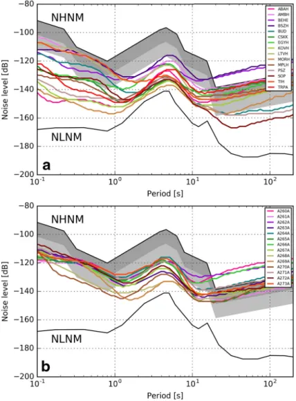
From the PSD data we computed median noise curves. The results for the vertical and horizontal (N) components are shown in Figs.3 and4. The NHNM and NLNM curves correspond to the New High and New Low Noise Models of Peterson (1993). The dark and light gray zones show the noise levels which lie between the NHNM and NHNM-10 dB, and between the NHNM-10 dB and NHNM-20 dB curves, respectively.
8.1 Vertical component noise
The vertical component median PSD curves for the HNSN permanent and temporary AlpArray stations are shown in Fig.3a and b. It must be noted that for every station the curves are below the NHNM level.
Based on the AlpArray Seismic Network quality requirements (see in Sect.4) and the observed noise characteristics, it is worth dividing the period range into three parts. For periods less than 1–2 s, the majority of the PSD curves belonging to the permanent stations are below the-10 dB level (Fig.3a), they exceed it only at four stations (AMBH, BSZH, LTVH, TIH—which are deployed in deep sedimentary basins with the exception of TIH lying next to Lake Balaton). Further four stations (BEHE, BUD, EGYH, SOP) are in the zone between the-10 and-20 dB levels. The remaining stations have favourable short period noise characteristics, they median PSD curves run under the-20 dB level. For the period range between 2 and 20 s, all the PSD curves lie below the-20 dB level, and they run together in a band narrower than 20 dB. For periods longer than 20 s, only two PSD curves (BUD, BSZH) run above the-20 dB level.
In the case of the temporary AlpArray stations (Fig.3b), in the short period range (under 1–2 s) the noise characteristics are considerably worse than for most permanent stations.
This is due to the fact that most of the temporary stations are deployed in sedimentary basins. All stations but two (A268A, A270A—which are installed on rock outcrops, therefore have better noise characteristics) are in the zone between the-20 dB and NHNM levels. Between 2 and 20 s periods, as for the permanent stations, all PSD curves are below the-20 dB level. For the range above 20 s, only an insignificant portion of 2–3 curves are above the-20 dB level.
Fig. 3 Vertical component median power spectral density (PSD) curvesafor the permanent stations of the Hungarian National Seismological Network andbfor the temporary AlpArray stations. The vertical axis shows the noise level in dB relative to 1 (m/s2Þ2/Hz. NHNM: New High Noise Model, NLNM: New Low Noise Model (Peterson1993); dark gray zone: noise levels between NHNM and NHNM-10 dB; light gray zone: noise levels between NHNM-10 dB and NHNM-20 dB. (Color figure online)
As a summary, it can be concluded that the stations of the Hungarian National Seis- mological Network have satisfactory vertical noise levels with only two exceptions; every temporary AlpArray station and 13 out of 15 permanent stations meet the AASN noise requirements.
8.2 Horizontal component noise
For the description of the horizontal noise characteristics the north-south component has been chosen. The corresponding PSD curves for the HNSN permanent and temporary AlpArray stations are shown in Fig.4a and b, respectively.
Fig. 4 Horizontal (N) component median power spectral density (PSD) curvesafor the permanent stations of the Hungarian National Seismological Network and b for the temporary AlpArray stations. For explanations of the abbreviations and markings, see Fig.3. (Color figure online)
In the case of the permanent stations at short periods only six PSD curves (belonging to stations deployed on rock: ABAH, KOVH, MORH, MPLH, TRPA, PSZ) run below the -20 dB level and there are four stations (AMBH, BSZH, LTVH, TIH) where the curves are above the -10 dB line. In this period range there is no station whose PSD curve is above the high noise level. For periods between 2 and 10 s, all but three PSD curves (AMBH, BEHE, BSZH) are below the-20 dB level. In the long period range there are only three stations (BUD, PSZ, SOP) whose noise is lower than the-20 dB level (these stations are deployed in cellars carved in rocks). The majority of the PSD curves are located between the NHNM and-10 dB levels. There are two stations (BEHE, BSZH) whose horizontal noise levels are significantly worse than the high noise model.
For the AlpArray stations in the sort period range there is only one station (A270A) whose PSD curve is clearly below the-20 dB level. It must be noted that in this period range the most PSD curves run rather close to each other. They approach most closely the high noise model at periods 0.2–1 s. Between 2 and 10 s, all the curves are below the -10 dB level and most of them are even below the-20 dB level.
In the long period range (above 20 s) there are three PSD curves (A260A, A262A, A266A) significantly above the high noise model, the remaining eleven are practically located between the NHNM and-10 dB levels.
In order to be able to evaluate the horizontal noise levels in the light of the require- ments, we have to treat the noise levels for short and long periods separately. The noise levels in the short period range comply with the requirements for all stations of the temporary and permanent networks. However, the situation is completely different for the horizontal long period noise. The criteria are met only for 8 stations out of 15 in the case of the permanent stations, and for another 8 cases among 14 temporary stations.
Fig. 5 Average of the vertical and horizontal component median power spectral density curves for the Hungarian stations deployed on rocks (violet) and in sedimentary basins (green). For explanations of the abbreviations and markings, see Fig.3. (Color figure online)
8.3 Average noise in different geological environments
It is worth comparing the average noise characteristics of the stations deployed on hard rock and in sedimentary basins with usually thick Cenozoic unconsolidated sediments. In Fig.5we present the averaged median PSD curves for these two types of station locations.
It can be seen that the vertical PSD curve for the stations installed on hard rock is below the -20 dB level for every period. The averaged vertical noise curve for the sedimentary basin sites, however, runs higher in the whole period range, the largest separation can be observed at short and long periods where the difference can reach values of around 20 dB.
Considering the horizontal components, we find that at periods less than 10 s the rock site average PSD curve runs below the-20 dB level and almost in the whole period range the basin sites can be characterised by higher noise. The maximum separation of basin and rock horizontal PSD curves is around 20 dB and this value is characteristic for shorter periods. In the case of longer periods the difference is considerably smaller and both curves approach the NHNM from below.
It is worth comparing the average vertical and horizontal PSD curves for the different site types. For periods shorter than 10 s the difference between the vertical and horizontal curves is not significant for both types of sites, however for the longer periods it grows excessively, in the case of the rock sites it even reaches a value of around 40 dB.
9 Conclusions
We have installed 14 new temporary online broadband stations in the territory of Western- Hungary. Eleven stations were financially supported by the Hungarian Academy of Sci- ences, three station equipment were provided by the Swiss-AlpArray SINERGIA program.
The AlpArray project officially started on 1 January 2016, the planned operating period of the stations is 3 years. By the beginning of March 2016 thirteen temporary stations had been already deployed, while the last station was installed in July 2016.
During the deployments of the temporary stations we closely followed the guidelines of the AlpArray Technical Strategy. The final sites are within the 6 km radius of the planned station locations. Every station is equipped with online broadband sensors, the sampling rate is 100 sps and for the timing we use GPS receivers. The data of both the permanent and temporary stations are collected by the EIDA.
Using the data of 1 year operation we examined the noise performance both of the permanent and temporary stations. According to the power spectral density computations the noise on the vertical and the short period horizontal components typically meet the requirements, but this is not the case regarding the long period horizontal noise. These experiences are mostly consistent with the observations made during the AlpArray station deployments in Austria (Fuchs et al. 2015), Italy (Govoni et al. 2017), Switzerland (Molinari et al.2016) and the Czech Republic (Vecsey et al.2017).
Despite the fact that most of the Hungarian stations are located in sedimentary basins, the measured noise levels meet the criteria reasonably well. Therefore the network as a whole will certainly provide the necessary information to address each of the scientific objectives outlined in Sect.2and the research activities related to the AlpArray project can significantly improve our knowledge on the structure and geodynamics of the transition zone between the Eastern Alps and the Pannonian basin.