DOI: 10.1556/606.2018.13.1.12 Vol. 13, No. 1, pp. 137–144 (2018) www.akademiai.com
INFILTRATION EXPERIMENTS: REALIZATION AND EVALUATION
1 Michaela ýERVEĕANSKÁ, 2 Adam JANÍK, 3 Dana BAROKOVÁ
Department of Hydraulic Engineering, Faculty of Civil Engineering
Slovak University of Technology in Bratislava, Radlinského 11, 810 05 Bratislava, Slovakia e-mail: 1michaela.cervenanska@stuba.sk,2adam.janik@stuba.sk, 3dana.barokova@stuba.sk
Received 30 December 2016; accepted 18 September 2017
Abstract: Drainage channels are artificial multi-functional elements in a landscape, which have their own specific functions. Although they are primarily used for the drainage of water, they can also even be used for an opposite function, i.e. the artificial water supply of specific regions. This article presents an evaluation of infiltration experiments in drainage channels in the southeastern part of Slovakia. These experiments served for the collection of input data for numerical modeling, especially the determination of the soil type and hydraulic conductivity. The methodology of experimental works in the field as well as some basic information about their evaluation is included.
Keywords: Drainage channel system, Infiltration experiment, Kostiakov model, Medzibodrožie region
1. Introduction
Drainage channels have been constructed because of the intensification of agricultural production and the drainage of internal waters. Due to changes in the agricultural policies of Slovakia, no attention to channels (both irrigation and drainage) is foreseen. In the past, the issue of using channels for an opposite function, i.e. an artificial water supply, was solved in cooperation with colleagues from Hungary within the INTERREG IIIA project [1]. However, the implementation of the project fell below expectations; it was therefore necessary to look for other options for the flooding of these regions. One of them is an ongoing project funded by the Slovak Research and Development Agency (an APVV project).
This article presents an evaluation of infiltration experiments in the region of Medzibodrožie that have been realized within the APVV project. The project deals with an assessment of the current state of the drainage channels in Slovakia as well as with intended measures to improve their functions in the future. The project is taking place in several regions of the Slovak Republic at the same time. One of these localities is the above-mentioned Medzibodrožie region, an area between the Tisa, Latorica and Bodrog rivers. The area of interest is located in the southeastern part of Slovakia, near its borders with Ukraine and Hungary.
The aim of the project in this region is the utilization of the water level and discharge regime of the existing drainage channel system by improving the water regime of the Tice River by artificial flooding. The Tice, an old river branch of the Tisa River, represents a significant wetland system, which is part of the NATURA 2000 nature protection areas. The proposed contribution deals with a determination of the input parameters for the definition of the infiltration properties of soils [2] located directly in the riverbeds of the drainage channels in the area of interest (Fig. 1). These parameters are necessary for estimating the water losses (infiltration into the subsoil) in a hydraulic assessment of the possible waterlogging of the wetlands system of the 44 km-long Tice River through the existing drainage channel system. The required water level and flow rate regime will be created by an artificial water supply from the Latorica and Bodrog rivers using the BoĐ and Pavlovo Pumping Stations (PS), which are located in the final profiles of the corresponding channels (the Leles and Pavlovo channels) [3]. The calibration and verification of the proposed solution is the topic of a large field experiment, which will be realized in the summer and autumn of 2017.
Fig. 1. The area of interest for the possible flooding of the Tice
The first phase of the project, which was realized in October and November 2015, was the reconnaissance of the field and selection of specific sites for the project’s
solution. The second phase, undertaken in July 2016, mainly consisted of fieldwork, i.e.
the measurement of the infiltration capacity of the soils located in the area.
2. Materials and methods
Infiltration is the process of the penetration of water into the soil from the ground surface; the intensity of this process is known as the infiltration rate. The infiltration rate is simply how fast water enters soil. There are many factors influencing this rate, including the soil’s texture and structure; its properties, including its porosity and hydraulic conductivity; its current moisture content, its surface conditions; and its vegetative cover [4]. This rate becomes constant when the saturated infiltration rate for the particular soil has been reached [5]. Devices known as infiltrometers are used to measure the infiltration rate.
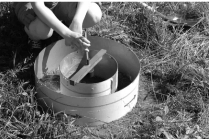
One of the most common infiltrometer designs for measuring a one-dimensional flow is a Double-Ring Infiltrometer (DRI) (Fig. 2), which consists of two open, thin- walled metal inner and outer cylinders, which are concentrically driven into the soil to a depth of 5 to 10 cm. The water is ponded to the same depth in both rings [6]. The purpose of the outer ring is to establish 1-D flow conditions (with vertical streamlines) for the inner ring (therefore, the water level in the outer ring is maintained at a constant level), while the flow from the outer ring may diverge laterally due to ‘edge effects’ [7].
Fig. 2. Placing a double-ring infiltrometer in the bottom of a drainage channel
Two techniques are used with the DRI for measuring the flow of water into the ground , i.e. the constant head test and the falling head test. In the constant head test, the water level in the inner ring is maintained at a fixed level and the volume of water used to maintain this level is measured. In the falling head test, the time that the water level takes to decrease in the inner ring is measured [5], [8].
To determine the infiltration rate for three different localities, i.e. the BoĐ, Hrušov, and Pavlovo pumping stations, four constant head tests using the DRI were realized (Table I).
Table I
Information about each infiltration experiment realized
Locality Datum Weather Duration of the test [min]
BoĐ(channel bottom) 12.7.2016
Sunny, 30°C (last rainy day:
9.7.2017)
64.9
Hrušov 12.7.2016 64.0
PS Pavlovo I 13.7.2016 121
PS Pavlovo II 13.7.2016 130
2.1. Theory of infiltration and the Kostiakov equation
The theory of infiltration is primarily based on two fundamental laws, i.e. the continuity equation (1) and Darcy’s law (2) [9]:
=0
∂ +∂
∂
∂ z q t
θ , (1)
( )
z k hq ∂
− ∂
= θ , (2)
where ș is the soil water content; q is Darcy’s moisture flux; t is the time; z is the vertical or elevation head; k is the hydraulic conductivity (a function of the soil water content); and h is the hydraulic head, which is expressed as:
z
h=ψ+ , (3)
where ȥis the capillary head. From the above equation, it is clear that the capillary head at any time depends on the soil moisture at that time. This implies that hydraulic conductivity is a function of the soil moisture content.
For evaluating the observed field data, the Kostiakov empirical infiltration model was used:
• for the cumulative infiltration
β α
αt it
i v1 1 1
1 =
= − − , (4)
• for the infiltration rate α
=vt−
v 1 , (5)
where v1 is the infiltration rate at the end of the first time unit; i1 is the cumulative depth of infiltration at the end of the first time unit; t is the elapsed time; and Į, ȕ are the empirical parameters.
3. Results and discussion
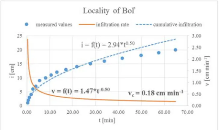
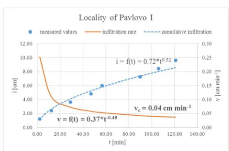
Using (4) and (5), the observed data was evaluated, i.e. the cumulative infiltration equation i = f(t) and the infiltration rate equation v = f(t) for all four experiments were determined (Fig. 3 - Fig. 6).
In most situations the infiltration rate is generally highest when the soil is dry. As the soil becomes wet, the infiltration rate gradually decreases over time until a constant final rate is attained.
Despite the similarity in the units of the infiltration rate and saturated hydraulic conductivity, there is a difference between these two parameters. The infiltration rate is defined as the rate at which soil is able to absorb rainfall or irrigation water and is governed by gravity and capillary action [10]. When all the pores are filled with water, the soil is saturated and is at its maximum retentive capacity. The maximum rate of infiltration is at the initial time (t = 0); it decreases as more water infiltrates into the soil as the time increases and achieves an almost constant rate, i.e. the ultimate infiltration capacity vc[11].
Fig. 3. The course of the cumulative infiltration and infiltration rate, the locality of BoĐ
Fig. 4. The course of the cumulative infiltration and infiltration rate, the locality of Hrušov
Fig. 5. The course of the cumulative infiltration and infiltration rate, the locality of Pavlovo I
Fig. 6. The course of the cumulative infiltration and infiltration rate, the locality of Pavlovo II The infiltration rate and hydraulic conductivity can only be directly related when the hydraulic boundary conditions (the hydraulic gradient and the extent of the lateral flow of the water) are known. The assumption behind using the DRI is that the soil layer immediately below the ponded area is fully saturated; the water is supplied at the soil surface under zero ponded conditions; and the hydraulic gradient is equal to one [10].
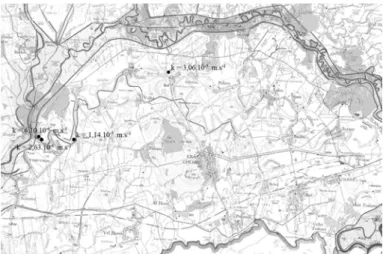
Under these conditions (using Darcy’s law (2)), the ultimate infiltration capacity equals the saturated soil’s hydraulic conductivity [12]. The values of the hydraulic conductivity for all the locations can be seen in Fig. 7.
The evaluation of the infiltration experiments (determination of the hydraulic conductivity) shows that the soil in these locations can be categorized as clay-loam with a relatively small hydraulic conductivity, as was also mentioned in [13]. The information about the soil type and also about its infiltration properties will be used as input data for a mathematical model that will represent the interaction of the surface water and groundwater in the soil conditions of the East Slovak Lowlands.
Note: The size of the cylinder is one potential source of error. The dependence of the hydraulic conductivity on the diameter of the cylinders used has been studied by several researchers, for example [5], [7] and [14]. Other researchers have studied the effect of the initial soil properties and setting-up conditions on the measured infiltration rate [15] and [16].
Fig. 7. Final values of the hydraulic conductivity in the particular locations
4. Conclusion
The present paper deals with a determination of the input data for a definition of the infiltration properties of soils located directly in the riverbeds of drainage channels in the East Slovak Lowlands. These parameters are necessary for estimating the water losses (infiltration into the subsoil) during a hydraulic assessment of the possible waterlogging of the wetlands system of the Tice River through the existing drainage channel system. The required water level and flow rate regime will be created by an artificial water supply from the Latorica and Bodrog rivers using pumping stations.
The infiltration capacity was measured using a double-ring infiltrometer. The data observed were evaluated using Kostiakov equations.
The evaluation of the infiltration experiments shows that the soil in these locations can be categorized as clay-loam with a relatively small hydraulic conductivity. These values will be used as input data for a mathematical model representing the interaction of the surface water and groundwater in the soil conditions in the mentioned areas.
Acknowledgements
The contribution was developed within the frame and based on the financial support of the APVV-14-0735 project ‘New possibilities of use of drainage channels taking the biodiversity in a landscape into account’.
The contribution was also developed within the frame and based on the financial support of the APVV-15-0489 project ‘Analysis of droughts by multi-criterial statistical methods and data mining from the viewpoint of prevention structures in a landscape’.
References
[1] Šoltész A. Hydraulic aspects of cross-border cooperation in River Restoration Project, Annual 2008 of the Croatian Academy of Engineering, Zagreb, Croatia, Croatian Academy of Engineering, 2008, pp. 31–47.
[2] Kozma Z., Ács T., Koncsos L. Hydrological modeling of the unsaturated zone - Evaluation of uncertainties related to the FAO soil classification system, Pollack Periodica, Vol. 2, No.
3, 2007, pp. 163–174.
[3] Pálinkášová Z., Šoltész A. Hydrologic and hydraulic evaluation of drainage system in eastern Slovak Lowland, Pollack Periodica, Vol. 8, No. 3, 2013, pp. 91–98.
[4] Yuan L. H., Fan G. S. The experiment study on the soil infiltration characteristics of Yumenkou water pumping station irrigation district of regional scale, Applied Mechanics and Materials, Vol. 316-317, 2013, pp. 661–664.
[5] Gregory J. H., Dukes M. D., Miller G. L., Jones P. H. Analysis of double-ring infiltration techniques and development of a simple automatic water delivery system, Applied Turfgrass Science, Vol. 2, 2005, pp. 1–7.
[6] Swartzendruber D., Olson T. C. Sand-model study of buffer effects in the double-ring infiltrometer, Soil Science Society of America Journal, Vol. 25, No. 1, 1960, pp. 5–8.
[7] Bouwer H. Intake rate: Cylinder infiltrometer, In: Methods of soil Analysis, Part I, Physical and mineralogical methods (Ed. A. Klute), American Society of Agronomy and Soil Science Society of America, Madison, 1986, pp. 825–844.
[8] Rocheta V. L. S., Isidoro J. M. G. P., de Lima J. L. M. P. Infiltration of Portuguese cobblestone pavements - An exploratory assessment using a double-ring infiltrometer, Urban Water Journal, Vo. 14, No. 3, 2017, pp. 291297.
[9] Kutílek M. Water-management pedology, (in Czech) Státní nakladatelství technické literatúry, Prague, 1978.
[10] Fatehnia M., Tawfiq K, Abichou T. Comparison of the methods of hydraulic conductivity estimation from mini disk infiltrometer, Electronic Journal of Geotechnical Engineering, Vol. 19, 2014, pp. 1047–1063.
[11] Parbi P. K., Mishra S. K., Singh R. A Modification to Kostiakov and modified Kostiakov infiltration models, Water Resources Management, Vol. 21, No. 11, 2007, pp. 1973–1989.
[12] Benetin J. Water movements in soil (in Slovak), VydavateĐstvo Slovenskej akadámie vied, Bratislava, 1958.
[13] Mati R., Kotorová D., Gomboš M., Kandra B. Development of evapotranspiration of water supply of clay-loamy soil on the East Slovak Lowland, Agricultural Water Management, Vol. 98, No. 7, 2011, pp. 1133–1140.
[14] Swartzendruber D., Olsen T. C. Model study of the double ring infiltrometers as affected by depth of wetting and particle size, Soil Science, Vol. 92, 1961, pp. 219–255.
[15] Fatehnia M., Tawfiq K, Ye M. Estimation of saturated hydraulic conductivity from double- ring infiltrometer measurements, European Journal of Soil Science, Vol. 67, 2016, pp. 135–147.
[16] Ruggenthaler R, Meißl G., Geitner C., Leitinger G., Endstrasser N., Schöberl F.
Investigating the impact of initial soil moisture conditions on total infiltration by using an adapted double-ring infiltrometer, Hydrological Science Journal, Vol. 61, No. 7, 2016, pp. 1263–1279.