1
Published as:
2
3 Kázmér, M., Al-Tawalbeh, M., Győri, E., Laszlovszky, J., Gaidzik, K. (2021): Destruction of the 4 royal town in Visegrád, Hungary – historical evidence and archeoseismology of the 1541 5 AD earthquake at the proposed Danube dam site. – Seismological Research Letters 92(5), 6 3202-3214. Featured in Nature
7 8 https://doi.org/10.1785/0220210058 9
10
Destruction of the royal town at Visegrád, Hungary – historical evidence and
11
archeoseismology of the 1541 AD earthquake at the proposed Danube dam site
12 13
Miklós Kázmér1,2, Mohammad Al-Tawalbeh1, Erzsébet Győri3, József Laszlovszky4, Krzysztof 14
Gaidzik5 15
16 1Department of Palaeontology, Eötvös University, Budapest, Hungary. mkazmer@gmail.com 17 2MTA-ELTE Geological, Geophysical and Space Science Research Group, Budapest, Hungary.
18
moh_tawalbeh89@yahoo.com
19 3ELKH FI Kövesligethy Radó Seismological Observatory, Budapest, Hungary 20
gyori@seismology.hu
21 4Department of Medieval Studies, Central European University, Budapest, Hungary –Vienna, 22
Austria.
23
Laszlovj@ceu.edu
24 5Institute of Earth Sciences, University of Silesia, Sosnowiec, Poland.
25
krzysztof.gaidzik@us.edu.pl 26
27
Declaration of Competing Interests: The authors acknowledge there are no conflicts of interest 28
recorded.
29
30 Abstract 31
32
The Danube Bend is the site of the proposed Nagymaros dam, part of the Gabčikovo-Nagymaros 33
hydropower complex in Slovakia and Hungary. The dam was designed in the 1970s to resist 34
intensity VI seismic events. We present historical and archaeological evidence for an intensity 35
IX earthquake on 21 August 1541, which destroyed buildings of the royal town of Visegrád.
36
Evidence includes vertical fissures cutting through the 30 m high, 13th century donjon Salamon 37
Tower, built on hard rock. Some parts of the adjacent 15th century Franciscan friary, built on the 38
alluvial plain, collapsed due to liquefaction of the subsoil. The date of a potentially responsible 39
earthquake on 21 August 1541 was recorded in a sermon of the eyewitness Lutheran minister 40
Péter Bornemisza, living at Pest-Buda, 35 km away. Taken by the Ottoman army in 1544, the 41
royal town and the fortress lost strategic importance, never to be rebuilt. Photographs and 42
drawings of the donjon made three centuries later faithfully reflect the status of 16th century 43
seismic damage, corroborated by modern archaeological excavations in the ecclesiastic complex.
44 45
Introduction 46
47
The Danube Bend in Hungary is the site where the second largest river in Europe crosses the 48
Transdaubian Midmountains, actively carving a 200 m deep gorge in bedrock (Ruszkiczay- 49
Rüdiger et al., 2005, Karátson et al., 2006). The U-shaped turn of the river might reflect as yet 50
unknown tectonic processes (Fig. 1). The site has been favoured for damming the river for 51
almost a century. This came close to true when Czechoslovakia and Hungary joined forces to 52
build the Gabčikovo-Nagymaros hydropower complex in the 1970s (Salewicz, 1991; Fürst, 53
2006). Seismicity of the region was considered minimal; there were neither recent nor historical 54
earthquakes known nearby the planned installations (Réthly, 1952; Zsíros et al., 1988). The 55
proposed dam at Nagymaros within the Bend was designed to resist earthquake shaking of 56
intensity VI on the MSK-64 scale (Mistéth, 1987). Engineering geological studies in the 57
foundation trenches did not find any seismic indicator (Gálos et al., 1988). Later, however, 58
doubts were raised about seismic safety (Cserepes et al., 1989). A suggestion that design 59
intensity should be IX was rejected by structural engineers based on apparent millennial integrity 60
of medieval fortifications nearby (Mistéth,1994). Ultimately, as a result of the political changes 61
in 1989, the Hungarian government withdrew from the project, inviting international arbitration 62
to ease tensions between the two states. The issue of whether Hungary should or should not build 63
the Nagymaros dam is still unsettled today (Fuyane and Madai, 2001). In this paper we present 64
historical, archaeological data, and archaeoseismological evidence indicating severe destruction 65
of medieval buildings by an earthquake near the proposed dam.
66 67
Methods 68
69
Two buildings were studied in detail: Salamon Tower and the Franciscan friary next to the royal 70
palace. Historical note on other monasteries and palaces within town were also taken into 71
account. Stratigraphic analyis of excavated soil layers and their relationship to foundations of 72
medieval buildings were used to interpret different architectural elements of various building 73
complexes. Surviving wall structures of medieval buildings were interpreted with building 74
archeological techniques and the results were incorporated into architectural-historical 75
conclusions. Various damage features within the buildings were identified, measured and 76
described, based on careful field work. Observed features were documented by drawings and 77
photographs, both by single shots and structure-from-motion technique (Forlin et al., 2017).
78
Dimensions, orientation and tilt angles were measured using laser range finder, measuring tape, 79
and a clinometer. A novel method was used to characterize featureless deformed floors (Kázmér 80
and Al-Tawalbeh, 2021). The subsided surface was divided by grid points in a 10 cm by 10 cm 81
network. A laser device (Bosch Universal Level 2) and a measuring pole with cm subdivision 82
was used to measure elevation differences. TIN interpolation by ArcGis 10.4 yielded a 3D model, 83
labelled by the Corel X5 graphic software. The ESI-2007 Environmental Seismicity Intensity 84
scale (Michetti et al., 2007) was used to determine the intensity of the seismic event.
85 86
Visegrád in the Danube Bend 87
88
The twin settlements of Visegrád and Nagymaros are facing each other about 600 m apart on the 89
right and left bank of the Danube river, respectively (Fig. 1). Visegrád had been one of the royal 90
residences of the Kingdom of Hungary between the 13th and the 16th centuries, and the capital 91
of the country in the 14th century, while Nagymaros was a prosperous trading settlement in the 92
Middle Ages. From the middle of the 16th century, upon occupation of much of Hungary by the 93
Ottoman empire, the town declined, never regaining its previous importance. Construction 94
ceased, buildings were abandoned, robbed for stone, and finally covered by landslides (Iván, 95
2004).
96 97
Both Visegrád and Nagymaros were built on the lowest, Pleistocene terrace of the Danube, 98
extending onto the adjacent mountain apron (Pécsi, 1959). We studied the very few surviving 99
medieval buildings in Visegrád, namely Salamon Tower, a 13th century donjon, the royal palace 100
complex and the adjacent Franciscan friary (Kázmér et al., 2019) to find evidence for any past 101
seismic events.
102 103
Salamon Tower 104
105
Salamon Tower, built on and made of Miocene andesite pyroclastics (Török, 2008) stands about 106
35 m above the river on a steep hillside in the northern outskirts of Visegrád town. Its plan forms 107
an elongated hexagon, 30 m long in north-south direction and 17 m wide. Elevation is preserved 108
up to 30 m height (Fig. 2). The tower was the centre of the lower castle of the Visegrád 109
fortification system, controlling river and road traffic of the Danube Bend in tandem with the 110
upper fortress on the hilltop 200 m above. Salamon Tower was built by King Béla IV in the late 111
13th century for a royal residence. It underwent architectural changes in its internal structures in 112
the 14th century. Later it was converted for purely military purposes.
113 114
The tower had five floors. The walls are uniformly 3.5 m thick, except in the southern and 115
northern corners, where they are 8 m thick. There are windows surrounded by carved frames 116
both on the eastern and western sides at each level. A staircase, embedded within the 8 m thick 117
wall of the southern corner, provided access to the floors.There is a huge collapse scar where the 118
southern corner had been, revealing five floors of open space within the building. Vertical 119
fractures transect each standing wall. The destruction and the damage of this corner of the tower 120
are connected to a military siege of the lower castle complex.
121 122
The siege in 1540 made the southern corner collapse due to four days of cannonfire (left side in 123
Fig. 2). The lower castle complex and the tower, occupied by the Ottoman army four years later, 124
lost its strategic importance, never to be rebuilt to its original purpose. Still remembered as a 125
royal residence in the 19th century, it has been subject to various restoration attempts, some of 126
them applying stone materials in the 19th century, as well as concrete on the damaged and 127
destroyed facade parts, a widespread restoration method in the 1970s. Plastering and inserting 128
new stones in the facade effectively covered all damage features (Bozóki, 2005, 2014), but they 129
can be studied on the architectural surveys and documentation of this historical monument 130
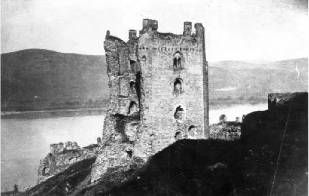
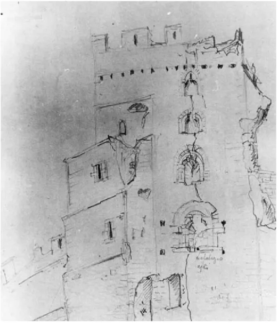
created before the restoration projects. Nineteenth-century images (drawings and photograps) 131
reveal the condition of the buildings right before 1544, the year of Ottoman conquest (Figs 2-3).
132
These allow archaeoseismological study to recognize damage features and assess them by 133
comparison to published images and to own photographs in the Archaeoseismological Database 134
(Kázmér and Moro, 2021).
135 136
Besides the obvious collapsed southern corner, victim to the 1540 siege (Iván, 2004), there are 137
further features of destruction, which cannot be related to cannonfire. The western facade bears a 138
conspicuous vertical fracture, connecting the weak zone of windows, across all five floors (Fig.
139
3). Earthquake-hit towers, like donjons or church towers, often bear similar fractures, located 140
halfway between opposing walls. The fractured towers of the kasbah of Sousse, Tunisia 141
(Bahrouni et al., 2020, their fig 4.2), of St. Peter’s church, Broadstairs, England (Musson, 2007, 142
his fig. 10), and of San Agustín church, Manila, Philippines (Saita et al. 2004, their fig. 5) are 143
good examples. Often one half of the tower collapsed, while the other half remained standing 144
(e.g. the clock tower in Finale Emilia in Italy; Acito et al., 2014). While the collapsed southern 145
corner is historically proven to be victim of cannonfire on 12 October 1540, all other fractures 146
developed in places protected from artillery. We suggest that these were formed by seismic 147
shaking.
148 149
Franciscan friary 150
151
There are extensive excavated ruins of a Franciscan friary adjacent to the royal palace in 152
Visegrád (Buzás et al., 1995). It was founded by King Sigismund in 1424-1425, expressing both 153
financial and spiritual closeness between the crown and the ’gown’ (the religous order), as 154
Laszlovszky (2009) put it. An east-west-oriented Gothic church, dedicated to Virgin Mary and 155
the attached, rectangular cloister building for the observant Franciscan order were built on the 156
lowest terrace of the river Danube. King Mathias provided funds for renovation and enlargement 157
in 1470-1480. The northern wing (cloister walk) of the rectangular cloister, being wider than the 158
rest, was constructed with a row of red marble columns to support the double row of vaults 159
erected during the time of King Vladislav II Jagello (ruled 1490-1516). There were friars’ rooms 160
above the vaulted corridors. There are no upright walls higher than 1.5 m preserved in the 161
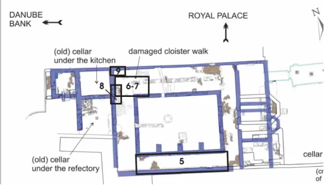
cloister, and therefore we studied the floor for deformation (Fig. 4).
162 163
Subsoil 164
165
The cloister was built right next to the hillslope in the east. Neither sand nor gravel of the former 166
riverbed was found during excavations (Fig. 5, Table 1). The 5 m deep well in the courtyard 167
(cloister garth) yielded ample amount of water, which had to be pumped throughout the 168
excavations. Clearly, the soil layers close to the surface in the cloister garth are landfill down to 169
1.8 m depth, as has been documented in various cross sections of archaeological sondages 170
excavated in this part of the building complex. The main walls of the cloister stand on 171
autochthonous clay, providing a solid foundation to the building.
172 173
Damage in the cloister part of the Franciscan friary 174
175
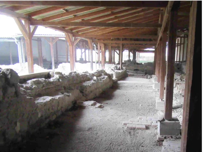
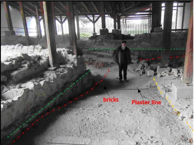
The cloister walk (a covered corridor with four wings sorrounding the rectangular cloister garth) 176
was floored with bricks embedded in mortar. The floor, originally horizontal and flat, displays an 177
undulating surface today (Fig. 6). Various parts of the floor are 10 to 80 cm below the original 178
level, marked by the top of the foundation walls (Fig. 4, Site 5). There is a distinct depression in 179
the northwestern corner, ~40 m2 in area, up to 80 cm deep (Fig. 4, Site 6-7, and Fig. 7). A 3D 180
model was created to show the shape of the otherwise featureless floor. The calculated volume of 181
the depression is 14 m3 (Fig. 8).
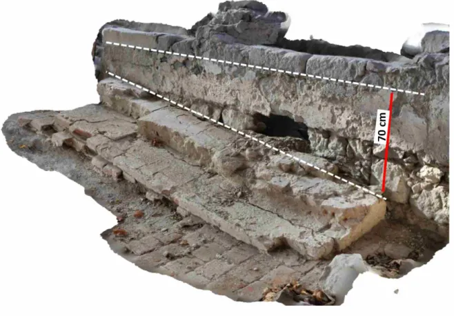
182 183
There is a stair of two steps on the western side of the depression (Fig. 4, Site 8 and Fig 9). Both 184
floor and stairs are tilted to the north. Original level is marked on Fig. 9. The northern 185
termination of the stairs is 70 cm deeper than the original location. The northern wall of the 186
cloister contains several holes(Fig 3, Site 9, and Fig. 10); these probably held beams of a 187
temporary wooden floor above the depression.
188 189
The foundation wall along the centre of the northern sector of the cloister – which supported the 190
red marble colonnade – displays uneven settlement of about 50 cm (Fig. 7).
191 192
Discussion 193
194
Flood versus earthquake – mechanism of damage 195
196
Archaeologists faithfully recorded destruction features (Buzás et al., 1995; Halász and Mordovin, 197
2002; Laszlovszky és Romhányi, 2003) during excavations in the late 1990s, attributing those to 198
warfare, abandonment, and stone robbing. Later Kiss and Laszlovszky (2013) suggested that 199
increased level of Danube floods in the early 16th century caused structural damage to the 200
cloister. These floods are well documented in historical records, and also at some archaeological 201
sites. However, Danube floods, usually lasting from a few days to a few weeks only, occur in 202
modern times, too. These damage furniture in flooded houses, may damage plaster on walls, but 203
do not cause damage to stone or brick masonry. Adobe buildings, however, collapse instantly 204
upon inundation. The Franciscan friary was a well-constructed stone masonry building; it 205
certainly did not collapse from flood. Frequent floods inundated the Dominican nunnery on 206
Margaret Island near Buda, about 35 km downriver. Narrative sources from the 13th century 207
onwards report floods influencing the daily life of the inhabitants there, never mentioning any 208
major structural damage to the buildings (Vadas, 2013). However, floor levels were often raised 209
to minimize the disturbing effects of frequent floods, as documented in various building on 210
Margaret Island.
211 212
Liquefaction 213
214
We suggest that the collapse of the northern cloister walk of the Franciscan friary was due to 215
significant deformation caused by liquefaction of the subsoil. The resulting uneven settlement 216
produced subsidence of buildings or their parts. Short-lived fountains and sand volcanoes could 217
develop on the surface, removing 14 m3 of sediment from below the floor (Fig. 7) (Bray and 218
Dashti, 2014; Győri, 2005).
219 220
The major walls of the cloister are standing on solid, grey clay. The soil below the brick 221
pavement of the cloister is loose landfill, partly excavated from foundation trenches. It contains 222
construction debris and archaeological objects (Fig 5, Table 1). The foundation wall under the 223
colonnade in the middle of the northern cloister walk was also laid down on this landfill. The 224
brick pavement all over the cloister walk is underlain by landfill, too. This is why both the 225
foundation of the columns subsided severely and the pavement subsided in all wings of the 226
cloister walk. Even in modern times the subsoil is saturated by water; inflowing water was 227
pumped from the well during excavation.
228 229
A spectacular depression was formed in the northwestern corner of the cloister: 0.8 m subsidence 230
of the floor was caused by escape of 14 m3 subsoil from below the floor. Only liquefaction- 231
induced escape of sediment-laden, overpressured water can remove such large amount of 232
material. The escape could have been laterally directed into the adjacent cellar to the west;
233
alternatively, it could have been filtered through tiny fissures in the brick floor, and subsequently 234
removed during cleanup after the catastrophe.
235 236
Another possibility to explain the reported damage to the friary cloister, also related to the 237
liquefaction event, is land slumping or lateral spreading induced by the earthquake shaking. A 238
significant part of the described damage took place in the part of the cloister closest to the river, 239
i.e. on the downhill side of the bank upon which the cloister was built (Fig. 4). Strong earthquake 240
shaking could have caused some minor slumping towards the river of the loose sediments at the 241
site, moving some earth material away from beneath the cloister. Perhaps some of that material 242
might have moved into the cellars, but it is also possible that a part of the hillside that included 243
the cloister simply moved downhill toward the river. An objection can be raised against this idea:
244
the friary is 180 m away from the riverbank. The remaining foundation walls are intact, did not 245
suffer any lateral deformation. Further planned excavations might clarify this issue.
246 247
Floor depressions in the cloister of the friary are not unique to Visegrád. Worlwide examples of 248
uneven settlement with depressions of similar dimensions (diameter and depth) associated with 249
strong earthquake shaking and liquefaction were described, among others, for Roman mosaics of 250
Monastir, Tunisia (Bahrouni et al. 2014), the Byzantine cathedral in Corinth, Greece 251
(Apostolopoulos et al., 2015; Minos-Minopoulos et al., 2015), in the city of Ferrara, Italy 252
(Caputo et al., 2016), and in Byzantine Gadara in Umm-Qais, Jordan (Fandi, 2018).
253 254 255
Which earthquake?
256 257
We are looking for an earthquake which might be responsible for the damage observed both on 258
the Franciscan friary and on the Salamon Tower. One must be aware that 90% of earthquakes 259
during the last millennium in the Carpathian-Pannonian region went unrecorded; therefore there 260
is not much chance to find the culprit (Kázmér and Győri, 2020).
261 262
When did the earthquake happen? There is no historical record preserved about the destruction at 263
Visegrád. We set up a detailed construction and restoration history of the Franciscan friary and 264
correlated it with the very few historical documents to bracket an interval in which the 265
catastrophic earthquake occurred (Table 2).
266 267
When did this thorough destruction happen? Destruction certainly happened after the Franciscan 268
convent met in 1513, probably after 1535, when still eight brethren inhabited the rooms above 269
the northern cloister walk, and possibly after 1539, when the monastery still had a full hierarchy 270
of inhabitants (name of the guardian is known), and when King John Zápolya had the royal 271
palace next door repaired in 1539. The terminus ante quem is the Turkish occupation of nearby 272
Esztergom in 1543 and of Visegrád proper in 1544.
273 274
Record of an earthquake on 21 August 1541 275
276
Historical earthquake records are mostly missing from 16th century Hungary (Kázmér and Győri, 277
2020). However, there is an interesting historical record available for the period between the 278
Austrian siege of 12 October 1540 and the Ottoman occupation of Visegrád in 1544 (Varga, 279
2017).
280 281
Péter Bornemisza (1536-1584), an important Lutheran minister and writer, wrote in one of his 282
sermons in Hungarian:
283 284
Hatod Ielről monda: Es leßnec Főld indulasoc bizonyos helyeken. Ez ackoris meg lett 285
midőn Chri-/stus wrunc Lelket ki boczatta, es halottaibol fel tamadot, Es az vtannis. Mi 286
időnkbennis Buda veßedel-/me előtt az Nap annira el veztette fenyet, hogy deelbe az 287
Czillagokat latnac, es olly föld indulas lett, hogy az polczrol az fazokac le hulnanac, es az 288
tornyokis romlanac, ottis Budan és Pesten az en házamba. (Bornemisza, 1584, p.
289
DCCVI).
290 291
In English:
292 293
On the sixth sign he said: there will be earthquakes at certain places. This happened 294
when our Lord Christ died and resurrected. Then, in our times, before the peril of Buda 295
the sun lost its light so much that at noon one saw the stars, and an earthquake happened, 296
pots fell from shelves, and towers damaged, in Buda and in Pest in my house.
297 298
This paragraph refers to the Book of Revelations in the Bible, verse 11,13: „And that same hour 299
there was a great earthquake, and a tenth part of the city fell”. The peril of Buda means the 300
arrival of the Ottoman army to occupy the castle on 29 August 1541. The loss of sunlight was 301
due to a partial solar eclipse (Kaposvári, 2006) on 21 August 1541. Bornemisza is considered a 302
reliable source, even though his sermon was put on paper decades after the event (Péter, 1996).
303
The child Bornemisza, living in Pest (now part of Budapest) at the age of six, could have 304
remembered these two frightening events, and family stories certainly made him remember that 305
there was an earthquake and an eclipse on the very same day. A record, when a historical date is 306
confirmed by an astronomical date, can be considered reliable (Guidoboni and Ebel, 2009).
307
Environmental historians dealing with historical records on catastrophic natural events 308
(earthquakes, floods, invasion of locusts) have recognized characteristic features of such texts 309
and the historical value of such reports have also been discussed. While catastrophic events 310
mentioned in the context of divine interventions or as signs for the activity of supernatural 311
powers are treated as less reliable or problematic, reports depicting actual events with minor 312
interesting details are often seen as confirming evidence for the historical value of the given text.
313
Furthermore, catastrophes recorded soon after the actual event or under special circumstances are 314
usually treated as important evidence, while stories described decades later are often less useful.
315
In an interesting and complex way, the above quoted paragraph written by Bornemisza shows 316
various characteristic features of such texts. Although the earthquake and solar eclipse are 317
discussed in a religious context, with the reference to Jesus Christ, the actual event with its 318
chronology is placed in the context of a well known historical fact. The conquest and occupation 319
of Buda and Pest by the Ottoman army was not only an important turning point in the history of 320
Hungary, but also a dramatic event in the personal life of Bornemisza. He grew up in Pest, and at 321
the age of six he has lost his parents during the events connected to the occupation of these 322
towns. He had to leave the place and the rest of his childhood was connected to other families in 323
other parts of the country.Therefore, we can speculate that events occuring right before this 324
dramatic change of his personal life survived as vivid memories for him decades later. This is 325
also corroborated by the fact that the date of the solar eclipse can be confirmed by astronomical 326
calculations, and it was definitely before the Ottoman occupation. Furthermore, the minor details 327
recorded in the context of the earthquake (falling pots, damaged towers) are typical features of 328
reliable historical sources on catastrophic events. These details are also coherent with the 329
memory of a six year old child, and they are based on eyewitness observations. Thus, we can 330
firmly conclude that Bornemisza’s report is a good and relevant source for a strong earthquake 331
for a period not much before the Ottoman occupation of Buda.
332 333
The Hungarian Earthquake Catalogue lists this event with an intensity of VI and magnitude 4.1 334
(Varga, 2017). This earthquake, as felt in Pest, might have had its epicentre elsewhere, closer to 335
Visegrád than to Pest.
336 337
Total destruction?
338 339
How much destruction was inflicted by the earthquake on the royal town of Visegrád? The most 340
solid building, Salamon Tower, boasting 3.5 to 8 m thick walls – already partially damaged by 341
cannonfire – had fractures in protected walls from top to bottom. Some vaults of the Franciscan 342
friary collapsed, and the cloister walkway floor suffered severe differential settlement due to 343
liquefaction of the subsoil. This collapse and liquefaction have occurred in those parts of the 344
building complex where vaults and floors were constructed on mixed infills. However, it is not 345
only architectural observation and archaeological evidence which indicate significant damage, as 346
visitors some time later described their experience about Visegrád.
347 348
David Ungnad was envoy of the Austrian emperor. On an official trip from Vienna in 1572, he 349
stopped at Visegrád en route to the Sublime Porte in Constantinople. The chronicler in his 350
entourage took notes of the decrepit condition of the royal castle and the friary (Ferus, 2007:99).
351
Another chronicler a few years later described the town of Visegrád as ruined (Gerlach, 1674:9).
352
Reinhard Lubenau, a German traveller from Königsberg, accompanied the Austrian ambassador 353
travelling from Vienna via the Danube to Constantinople. The team visited Visegrád in 1587 and 354
described the sad condition of the buildings there:
355 356
„...uber der Thona zur rechten Handt leidt eine gahr schone Festung aus einem hohen 357
Berge, zu welcher wir hinuber gefahren, dselbe zu besichtigen; unter dem Berge wahren 358
ein Hauffen // zerstöreter palatia, groser Herren Hauser, Kirchen und Klöster, auch ein 359
koniglich palatium, Lusthaus und Gartten auch grose Mauren und allerlei Gebeude, 360
elche alle zerstöret un sol Keiser Sigismundus dies palatium haben angefangen zu bauen, 361
und von Matha Corvino volendet worden, aber von den Turcken zerstöret..” (Sahm, 362
1912:76).
363 364
In English:
365 366
„...over the Danube on the right hand there is a nice fortress on a high mountain, where 367
we went to visit; under the hill there are houses, broken palaces, large noble houses, 368
churches and monasteries, also a royal palace, an event house, and garden and large 369
walls and other buildings, all of them destroyed. Emperor Sigismund started to build this 370
palace, Mathias Corvinus finished, but the Turks destroyed...”
371 372
Lubenau attributed all damage to the Turkish army, as heard from his guides. However, neither 373
the Austrian army in 1540 nor the Ottoman army in 1543-44 had any reason to attack 374
monasteries and other houses in town. Their aim was to occupy military installations; the lower 375
castle, including Salamon Tower near the river, and the upper castle on the hilltop. We suggest 376
that the severe damage to the town buildings was caused by the same earthquake which fractured 377
Salamon Tower and destroyed much of the Franciscan monastery.
378 379
Intensity 380
381
There are only low upright walls preserved in the Franciscan friary. Therefore, the Earthquake 382
Archaeology Effects scale (Rodriguez-Pascua et al., 2013) cannot be applied here. The 383
Environmental Intensity Scale (ESI07) lists: „liquefaction frequent, sand boils up to 3 m 384
diameter, settlement/subsidence of more than 30 cm but less than 1 m”. The 6 m diameter 385
depression in the cloister, 0.8 m deep, fits in this category, indicating intensity IX or higher 386
(Michetti et al., 2007). This high intensity earthquake in Visegrád could have been felt in Pest by 387
Bornemisza as intensity VI event (Varga, 2017) (Fig. 11).
388 389
These values are correlated with the previously used MSK-64 scale (Musson et al., 2010), used 390
in designing the Nagymaros dam (Mistéth 1987, 1994). One can see that design itensity VI, 391
applied for the dam in the 1970s, has been underestimated. Intensity IX – as suggested in the 392
1980s by experts of the Geophysical Institute but rejected by Mistéth (1994) – is a more realistic 393
value. Any further seismic design for critical facilities in the region of Visegrád need to consider 394
this event.
395 396
Causative fault 397
398
Extensive shallow seismic profiling along the Danube between Esztergom and Budapest 399
revealed large number of potentially active, mostly strike-slip faults across the riverbed. Their 400
number is several times higher than those known from outcrops on land (Oláh et al., 2014). We 401
can neither corroborate nor exclude that any of these were active in historical times. There was 402
no systematic survey for surface ruptures. Historical map studies on the changing Danube 403
riverbed (migrating sand banks, see e.g. Székely et al., 2009) offer new perspectives for future 404
landscape change studies in the region, keeping in mind the potential role of active tectonics.
405 406
Seismic hazard 407
408
The role of active tectonic processes regarding critical facilities was underestimated at the time 409
of the design of the Gabčikovo-Nagymaros hydropower complex in the 1970s. A similar 410
situation occurred during the re-assessment of seismic hazard for the Paks nuclear power plant, 411
200 km downriver, culminating in a spectacular, public professional debate (see Balla, 1999;
412
Tóth and Horváth, 1999). Potentially important, major landscape changes of tectonic origin in 413
the Danube Bend were pointed out – although not yet fully discussed – in the 2000s. (1) Rapid 414
late Quaternary uplift of surrounding hills simultaneous with downcutting of the Danube 415
riverbed (Ruszkiczay-Rüdiger et al., 2005, Karátson et al., 2006). (2) Large-scale changes in 416
river bed morphology documented on maps from the 16th century onwards, suggesting either 417
intense river dynamics or tectonic origin (Székely et al., 2009). (3) Rising flood level at the end 418
of the Middle Ages (Mészáros and Serlegi, 2011; Kiss and Laszlovszky, 2013; Kiss, 2019). (4) 419
Recognition of a dense, potentially active fault system in the riverbed (Oláh et al., 2014).
420 421
While seismicity based on historical and instrumental data are considered pretty well known in 422
the Carpathian-Pannonian region (Tóth et al., 2002), new historical data can be found any time.
423
Archaeoseismology – a new method for Hungary – provides further important information on 424
past damaging earthquakes. We suggest that historical seismology and archaeoseismology 425
should be integral part of environmental assessment for critical infrastructure facilities.
426 427
Conclusions 428
429
An archaeoseimological study was carried out on the damaged medieval Salamon Tower and 430
Franciscan friary at Visegrád in the Danube Bend, Hungary. The site is adjacent to a proposed 431
hydropower station, designed for seismic intensity VI. Features of earthquake-induced fracturing, 432
collapse, and liquefaction indicate that an earthquake of intensity IX destroyed buildings in the 433
town. The event is tied to a properly dated seismic event on 21 August 1541, in Pest, 35 km to 434
the south. Travelogues record that Visegrád was an abandoned ghost town in the decades 435
following this event. Seismic design of any critical facility should include studies on historical 436
seismology and archaeoseismology.
437 438
Data and Resources 439
440
The Earthquake Catalogue, version 2019 is maintained by the Geodetic and Geophysical 441
Institute, Research Centre for Astronomy and Earth Sciences, Hungarian Academy of Sciences, 442
Sopron, Hungary.
443 444
Declaration of Competing Interests 445
446
The authors acknowledge there are no conflicts of interest recorded.
447 448
Acknowledgements 449
450
Mohammad Al-Tawalbeh enjoyed a Stipendium Hungaricum PhD scholarship while preparing 451
this study. András Pálóczi-Horváth and Orsolya Dzsida assisted with Latin texts. Research by 452
Krzysztof Gaidzik is co-financed by funds granted under the Research Excellence Initiative of 453
the University of Silesia in Katowice. We are grateful for the thorough, helpful work of the 454
editor and of an anonymous reviewer, which greatly improved the manuscript. Their help is 455
sincerely acknowledged here.
456 457
References 458
459
Acito, M., M. Bocciarrelli, C. Chesi, and G. Milani (2014). ollapse of the clock tower in Finale 460
Emilia after the May 2012 Emilia Romagna earthquake sequence: Numerical insight, Eng.
461
Struct. 72 70-91.
462
Apostolopoulos, G, D. Minos-Minopoulos, and K. Pavlopoulos (2015). Geophysical 463
investigation for the detection of liquefaction phenomena in an archaeological site, 464
Lechaion, Greece, Geophysics 80 EN105–EN117.
465
Bahrouni, N, S. Bouaziz, A. Soumaya, N. Ben Ayef, K. Attafi, Y. Houla, A. El Ghali, and N.
466
Rebai (2014). Neotectonic and seismotectonic investigation of seismically active regions 467
in Tunisia: a multidisciplinary approach, J. Seismol. 18 235–256.
468
Bahrouni, N., M. Meghroui, K. Hinzen, M. Arfaoui, and F. Mahfoud (2020). The damaging 469
earthquake of 9 October 859 in Kairouan (Tunisia): Evidence from historical and 470
archeoseismological investigations, Seismol. Res. Lett. 98 1890-1900.
471
Balla, Z. (1999). Van-e bizonyíték negyedidőszaki tektonizmusra Paks környékén? („A paksi 472
atomerőmű földrengésbiztonsága” kötet megjelenése kapcsán), Földt. Közl. 129 97–107.
473
Balogh, J. (1966). A művészet Mátyás király udvarában. I-II. Akadémiai, Budapest, 799 + 509 p.
474
Bornemisza, P. (1584). Prédikatioc, egesz esztendő altal minden vasárnapra rendeltetett 475
Evangeliomból. Detrekoe.
476
Bozóki, L. (2005). Le tour dite „Salamon” comme residence royale en 14e siècle. Donjon, tours 477
maîitresses, tours fonction et représentation. In: Ribera, F. (ed.) Loci tra le rocce. Alinea 478
Editrice, Salerno, 401-406..
479
Bozóki, L. (2014). A visegrádi Salamon-torony építés és helyreállítás története, Archaeologia - 480
Altum Castrum Online, 1–40.
481
Bray, J. D., and S. Dashti (2014). Liquefaction-induced buildings movements, Bull. Earthq. Eng.
482
12 119–1156.
483
Buzás, G, J. Laszlovszky, Sz. Papp, Gy. Szekér, and M. Szőke (1995). The Franciscan friary of 484
Visegrád. (History, archaeological remains, the results of the 1990–1993 campaign). In 485
Laszlovszky, J. (ed.) Medieval Visegrád, Royal Castle, Palace, Town. and Franciscan 486
Friary. Dissertationes Pannonicae, series III, vol. 4, 26–33, Figs: 170–207 on pp. 144–
487
162 488
Caputo, R, M. E. Poli, L. Minarelli, D. Rapti, S. Sboras, M. Stefani, and A. Zanferrari (2016).
489
Palaeoseismological evidence for the 1570 Ferrara earthquake, Italy, Tectonics 35 423–
490
1445.
491
Cserepes, L., Gy. Bartha, and Hajósy A (1989). A nagymarosi vízlépcső-építkezés területének 492
tektonikai problémái, Hitel 1989 4, 51 493
Fandi, M. (2018). Effects of large historical earthquakes on archeological structures in Jordan, 494
Arabian J. Geosci. 11 9.
495
Ferus, A. (2007). Die Reise des kaiserlichen Gesandten David Ungnad nach Konstantinopel im 496
Jahre 1572. MA thesis, University of Vienna, 175 p.
497
Forlin, P., R. Valente, and M. Kázmér (2017). Assessing earthquake effects on archaeological 498
sites using photogrammetry and 3D model analysis, Digital Methods. Archaeol. Cultural 499
Heritage 9, e00073s.
500
Fuyane, B., and F. Madai (2001). The Hungary-Slovakia Danibe River dispute: implications for 501
sustainable development and equable utilization of natural resources in international law, 502
Int. J. of Global Env. Issues 1 329-344.
503
Fürst, H. (2006). The Hungarian-Slovakian Conflict over the Gabcíkovo-Nagymaros Dams: An 504
Analysis, Intermarium 6 2, 15 p.
505
http://www.columbia.edu/cu/ece/research/intermarium/vol6no2/furst.pdf Accessed 29 506
May 2020.
507
Gálos, M, P. Kertész, and I. Marek (1988). The general spatial system of rocky environment for 508
building purposes, Periodica Polytechnica, Civil Eng. 32 151–168.
509
Gerlach, S. (1674). Tagebuch…. David Ungnad… Gesandschafft. Frankfurt am Mayn.
510
Guidoboni, E., and J. E. Ebel (2009). Earthquakes and Tsunamis in the Past. A Guide to 511
Techniques in Historical Seismology. Cambridge University Press, Cambridge.
512
Győri, E. (2005). Site effect determination at liquefiable sites, Acta Geod. Geophys. Hung. 41 513
117–132.
514
Halász, Á, and M. Mordovin (2002). Adatok a visegrádi ferences kolostor építéstörténetéhez.
515
Aufgaben zur Baugeschichte der Franziskaner-Klosters von Visegrád, Comm. Archaeol.
516
Hung. 2002 231–250.
517
Iván, L. (2004). A visegrádi vár története a kezdetektől 1685-ig. Magyar Nemzeti Múzeum 518
Mátyás Király Múzeuma, Visegrád, 259 p.
519
Jovius, P. (1552). Pauli Jovii Novocomensis Episcopi Nucerini Historiarum Sui Temporis.
520
Tomus Secundus. Florentiae, 1227 p.
521
Kaposvári, Z. (2006). Magyarországról látható napfogyatkozások 1500-1599 között.
522
http://saros139.hu/eclipse/HE15.htm. (Accessed 2 January 2021) 523
Karátson, D., K. Németh, B. Székely, Zs. Ruszkiczay-Rüdiger, and Z. Pécskay (2006). Incision 524
of a river curvature due to exhumed Miocene volcanic landforms: Danube Bend, 525
Hungary, Int. J. Earth Sci. 95 929-944.
526
Kázmér, M., and M. Al-Tawalbeh (2021). 3D survey of featureless floors - an inexpensive 527
method using laser level and folding rule, Digital Methods Applic Archaeol. (in 528
preparation) 529
Kázmér, M., and E. Győri (2020). Millennial record of earthquakes in the Carpathian-Pannonian 530
region – historical and archeoseismology, Hung. Hist. Rev. 9 284-301.
531
Kázmér, M., and E. Moro (2021). The Archaeoseismological Database, Ann. Geophys. (in 532
preparation) 533
Kázmér, M.., M. Tawalbeh, G. Buzás, G, and J. Laszlovszky (2019). Tizenhatodik századi 534
földrengéskárok Visegrádon és Budán – történeti és archeoszeizmológia. Magyarhoni 535
Földtani Társulat, Földtani és Geofizikai Vándorgyűlés, Balatonfüred, 2019. október 3–5.
536
50–53 537
Kiss, A. (2019). Floods and Long-Term Water Level Changes in Medieval Hungary. Springer 538
Nature, Cham, xix + 896 p.
539
Kiss, A., and J. Laszlovszky (2013). 14th-16th century Danube floods and long-term water-level 540
changes in archaeological and sedimentarí evidence in the western and central Carpathian 541
Basin: an overview with documentary comparison, J. Env. Geogr. 6 1–11.
542
Laszlovszky, J. (2009). Crown, Gown and Town: Zones of Royal, Ecclesiastical and Civic 543
Interaction in Medieval Buda and Visegrád. In: Keene, D., B. Nagy, and K. Szende, (eds):
544
Segregation – Integration – Assimilation. Religious and Ethnic Groups in the Medieval 545
Towns of Central and Eastern Europe. Farnham, pp. 179–203.
546
Laszlovszky, J., and B. Romhányi (2003). Cathedrals, monasteries and churches: the 547
archaeology of ecclesiastic monuments. In Visy, Zs. (ed) Hungarian Archaeology at the 548
Turn of the Millennium. Teleki László Foundation, Budapest, 372-377.
549
Mészáros, O., and G. Serlegi (2011). The impact of environmental change on medieval 550
settlement structure in Transdanubia. Acta Archaeol. 62 199–219.
551
Michetti, A.M., E. Esposito, L. Guerrieri, S. Porfido, L. Serva, R. Tatevossian, E. Vittori, F.
552
Audemard, T. Azuma, J. Clague, V. Comeci, A. Gürpinar, J. McCalpin, B.
553
Mohammadioun, N. A. Mörner, Y. Ota, and A. Rogozhin (2007). Environmental Seismic 554
Intensity Scale 2007 – ESI 2007, Mem. Descr. Carta Geol. d’Italia. LXXIV. Servizio 555
Geologico d’Italia, Roma, 7–54.
556
Minos-Minopoulos D., K. Pavlopoulos, G. Apostolopoulos, E. Lekkas, and E. Dominey-Howes 557
(2015). Liquefaction features at an archaeological site: Investigations of past earthquake 558
events at the Early Christian Basilica, ancient Lechaion harbour, Corinth, Greece 559
Tectonophysics 658:74–90.
560
Mistéth, E. (1987). Stability of the Danube barrage system against earthquakes, Vízügyi Közlem.
561
69 184–205.
562
Mistéth, E. (1994). Sesimic stability of hydraulic structures. Hidrol. Közl. 74 9-14.
563
Musson, R. G. W. (2007). British earthquakes, Proc. Geol. Assoc. 118 305-337.
564
Musson, R M W, G. Grünthal, and M. Stucchi M (2010). The comparison of macroseismic 565
intensity scales, J. Seismol. 14 413–428.
566
Oláh, P., L. Fodor, T., Tóth, A. Deák, G., Drijkoningen, and F. Horváth (2014) .Geological 567
results of the seismic surveys around Szentendre Island, Danube river, North Hungary, 568
Földt. Közl. 144:351-380.
569
Pálóczi-Horváth, A. (2014). The early renaissance garden of the Royal Palace at Visegrád. The 570
results of environmental archaeological research. In Medieval Europe in Motion. In 571
honour of Jan Klápště. Archeologický ústav AV ČR, Praha, 291-314.
572
Pécsi, M. (1959). A magyarországi Duna-völgy kialakulása és felszínalaktana. Akadémiai Kiadó, 573
Budapest, pp 346.
574
Péter, K. (1996). Bornemisza, Péter. In: The Oxford Encyclopedia of the Reformation, 4 vols.
575
New York and Oxford, Oxford University Press, 1 201-202.
576
Réthly, A (1952). A Kárpátmedencék földrengései: 455-1918. Akadémiai Kiadó, Budapest.
577
Rodríguez-Pascua, M., P. G. Silva, R. Pérez-López, J.-L. Giner-Robles, F. Martín-González, and 578
M. A. Perucha. (2013). Preliminary intensity correlation between macroseismic scales 579
(ESI07 and EMS98) and Earthquake Archaeological Effects (EAEs). In: Grützner, C, A.
580
Rudersdorf, R. Pérez-López, and K. Reicherter (eds.), Seismic Hazard, Critical facilities 581
and Slow Active Faults. PATA Days. Proceedings of the 4th International INQUA 582
Meeting on Paleoseismology, Active Tectonics and Archaeoseismology (PATA), 9–14 583
October 2013, Aachen, Germany, pp. 221–224.
584
Ruszkiczay-Rüdiger, Zs., L. Fodor, G. Bada, Sz. Leél-Őssy, E. Horváth, and T. J. Dunai (2005).
585
Quantification of Quaternary vertical movements in the central Pannonian Basin: A 586
review of chronologic data along the Danube River, Hungary, Tectonophysics 410 157- 587
172.
588
Sahm, W. (1912). Beschreibung der Reisen der Reinhold Lubenau. 1. Teil. Mitteilungen aus der 589
Stadtbibliothek zu Königsberg i. Pr. IV. Beyers, Königsberg i. Pr.
590
Saita, J., M. L. P. Bautista, and Y. Nakamura, Y: (2004). On relationship between the estimates 591
strong motion characteristics of surface layer and the earthquake damage – case study at 592
Intramuros, Metro Manila. 13th World Conference on Earthquake Engineering 593
Vancouver, B.C., Canada, August 1-6, 2004, Paper No. 905, 7 p.
594
Salewicz, K.A. (1991). Management of large international rivers – practical experience from a 595
research perspective. In: Hydrology for the Water Management of Large River Basins 596
(Proceedings of the Vienna Symposium, August 1991). Int. Assoc. Hydrol. Sci. (IAHS) 597
Publ. 201 57-69.
598
Székely, B., G. Molnár, and G. Timár (2009). Lazarus secretarius and river dynamics – 599
cartographic errors or avulsion of the Danube? In Kázmér, M. (ed.) Környezettörténet. Az 600
elmúlt 500 év környezeti eseményei történeti és természettudományi források tükrében.
601
Hantken Kiadó, Budapest, 71–94.
602
Tóth, L., P. Mónus, T. Zsíros, and M. Kiszely (2002). Seismicity in the Pannonian Region – 603
earthquake data, Stephan Mueller Spec. Publ. Series 3 9–28.
604
Tóth, T., F. Horváth (1999). Van bizonyíték a negyedidőszaki tektonizmusra Paks környékén!, 605
Földt. Közl. 129 109–124.
606
Török, Á. (2008). Építészeti kőanyagok előfordulása és felhasználása a mai Magyarország 607
területén a XVIII. Századig, Miskolci Egyetem Közl. A., Bány., 74 137-155.
608
Vadas, A. (2013). Long-term perspectives on Danube floods. The Dominican nunnery on 609
Margaret Island (Budapest) and the Danube river, Interdisciplinaria Archaeologica. Nat.
610
Sci. Archaeol. 4 3–22.
611
Varga, P. (2017). Old Hungarian earthquakes, with particular regard to Budapest, M. Geofiz. 58 612
76-87.
613
Zsíros, T., P. Mónus, L. Tóth (1988). Hungarian earthquake catalog (456–1986). Seismological 614
Observatory, Geodetic and Geophysical Research Institute, Hungarian Academy of 615
Sciences.
616
Authors’ addresses 617
618
Miklós Kázmér 619
Department of Palaeontology, Eötvös University & MTA-ELTE Geological, Geophysical and 620
Space Science Research Group, Budapest, Hungary.
621
E-mail: mkazmer@gmail.com 622
623 624
Mohammad Al-Tawalbeh 625
Department of Palaeontology, Eötvös University, Budapest, Hungary 626
E-mail: moh_tawalbeh89@yahoo.com 627
628
Erzsébet Győri 629
Kövesligethy Radó Seismological Observatory, Budapest, Hungary 630
E-mail: gyori@seismology.hu 631
632
József Laszlovszky 633
Department of Medieval Studies, Central European University, Budapest, Hungary –Vienna, 634
Austria.
635
E-mail: Laszlovj@ceu.edu 636
637 638
Figure captions
639 640
Figure 1. Site of the proposed Nagymaros dam and medieval archaeological sites at Visegrád. Vintage
641
Google Earth image, dated 31 December 1994. The dam construction site is still visible, removed later.
642 643
Figure 2. V-shaped collapse damaged all six floors of Salamon Tower as seen in 1870. View from east.
644
The collapse scar on the left was caused by cannonfire on 12 October 1540. Note the vertical fracture
645
along the vertical row of windows – this is an indication of severe seismic shaking. Photograph by Sándor
646
Beszédes (FKF 52495N) (Bozóki 2014, fig. 2).
647 648
Figure 3. Vertical fissure across all six floors on the western facade of Salamon tower, a clear signal of
649
severe seismic shaking. Pencil drawing by Antal Gregus in 1872 (FKF 55908N) (Bozóki 2014, fig. 4).
650 651
Figure 4. Franciscan friary at Visegrád. Ground-floor plan of the cloister (after Kiss and Laszlovszky,
652
2013, modified). The southern wall is 3 m high, other walls are less than 1-1.5 m high. Numbers refer to
653
figures. 5 – floor of the rectangular, covered cloister walk has subsided by about 10-20 cm in average. 6-7
654
– site of 80 cm subsidence in the NW corner of the cloister walk. 8 – subsided stairs. 9 – beam holes to
655
support a wooden floor.
656 657
Figure 5. Excavated profile of subsoil at probe in the cloister garth.
658 659
Figure 6. Undulating floor in the southern sector of the cloister walk. Originally covered by bricks, now the
660
underlying plastered surface is visible. View to east. Site 5 on Fig. 4. Archaeological Database (ADB)
661
photo #6699.
662 663
Figure 7. Subsided floor of the cloister walk in the northwestern corner. Original floor level marked on left
664
with a green, horizontal, dashed line. Subsided floor marked with inclined, red dashed line. Maximum
665
subsidence is 80 cm, where person stands. A few floor bricks, embedded in mortar, are still in place.
666
Wooden columns, supporting protective roof of the excavated area, replace stone columns, which
667
supported a double vault. The latter collapsed during shaking, due to subsidence of its foundation (raised,
668
between aisles). Subsided, tilted stairs visible behind person (see Fig. 9). View to west. Sites 6-7 on Fig.
669
4. ADB photo #6705.
670 671
Figure 8. 3D model of 0.8 m deep depression in NW corner of cloister. View to east. Grid shows the
672
shape, grey tint marks depth. Pink: preserved bricks. Orange: plaster.Total calculated volume of ejected
673
material is ca 14 m³ in this part of the cloister.
674 675
Figure 9. Tilted and subsided stairs 70 cm below thresholds of the doors in the western wall of cloister
676
walk. Top of the stairs was at the upper dashed line before subsidence. 3D model by structure-from-
677
motion photography. View to SW. Site 8 on Fig.4. ADB photo #6724.
678 679
Figure 10. Holes for beams: one above the subsided stairs(!), indicating it was carved after subsidence.
680
There is another in the wall in the back. Beams supported a wooden floor, put above the useless stairs.
681
Fig. 6. Site 9 on Fig. 4. ADB photo #6707.
682 683
Figure 11. Instrumental and historical seismicity within 100 km radius around Visegrád. No major
684
earthquake was recorded in the vicinity of Visegrád before our study. Attenuation field for M > 5 EQ down
685
to intensity VII (EMS98). For data see Data and Resources section (Earthquake Catalogue 2019).
686
687
688 689
Figure 1. Site of the proposed Nagymaros dam and medieval archaeological sites at Visegrád. Vintage
690
Google Earth image, dated 31 December 1994. The dam construction site is still visible, removed later.
691 692
693
694 695
Figure 2. V-shaped collapse damaged all six floors of Salamon Tower as seen in 1870. View from east.
696
The collapse scar on the left was caused by cannonfire on 12 October 1540. Note the vertical fracture
697
along the vertical row of windows – this is an indication of severe seismic shaking. Photograph by Sándor
698
Beszédes (FKF 52495N) (Bozóki 2014, fig. 2).
699 700
701
702 703
Figure 3. Vertical fissure across all six floors on the western facade of Salamon tower, a clear signal of
704
severe seismic shaking. Pencil drawing by Antal Gregus in 1872 (FKF 55908N) (Bozóki 2014, fig. 4).
705
706 707
708 709
Figure 4. Franciscan friary at Visegrád. Ground-floor plan of the cloister (after Kiss and Laszlovszky,
710
2013, modified). The southern wall is 3 m high, other walls are less than 1-1.5 m high. Numbers refer to
711 figures. 5 – floor of the rectangular, covered cloister walk has subsided by about 10-20 cm in average. 6-7
712
– site of 80 cm subsidence in the NW corner of the cloister walk. 8 – subsided stairs. 9 – beam holes to
713
support a wooden floor.
714 715 716
717 718
Figure 5. Excavated profile of subsoil at probe in the cloister garth.
719
720
721 722
Figure 6. Undulating floor in the southern sector of the cloister walk. Originally covered by bricks, now the
723
underlying plastered surface is visible. View to east. Site 5 on Fig. 4. Archaeological Database (ADB)
724
photo #6699.
725
726 727
728 729
Figure 7. Subsided floor of the cloister walk in the northwestern corner. Original floor level marked on left
730
with a green, horizontal, dashed line. Subsided floor marked with inclined, red dashed line. Maximum
731
subsidence is 80 cm, where person stands. A few floor bricks, embedded in mortar, are still in place.
732
Wooden columns, supporting protective roof of the excavated area, replace stone columns, which
733
supported a double vault. The latter collapsed during shaking, due to subsidence of its foundation (raised,
734
between aisles). Subsided, tilted stairs visible behind person (see Fig. 8). View to west. Sites 6-7 on Fig.
735
4. ADB photo #6705.
736 737
738
739 740
Figure 8. 3D model of 0.8 m deep depression in NW corner of cloister. View to east. Grid shows the
741
shape, grey tint marks depth. Pink: preserved bricks. Orange: plaster.Total calculated volume of ejected
742
material is ca 14 m³ in this part of the cloister.
743 744
745
746 747
Figure 9. Tilted and subsided stairs 70 cm below thresholds of the doors in the western wall of cloister
748
walk. Top of the stairs was at the upper dashed line before subsidence. 3D model by structure-from-
749
motion photography. View to SW. Site 8 on Fig.4. ADB photo #6724.
750 751
752
753 754
Figure 10. Holes for beams: one above the subsided stairs(!), indicating it was carved after subsidence.
755
There is another in the wall in the back. Beams supported a wooden floor, put above the useless stairs.
756
Site 9 on Fig. 4. ADB photo #6707.
757
758
759 760
Figure 11. Instrumental and historical seismicity within 100 km radius around Visegrád. No major
761
earthquake was recorded in the vicinity of Visegrád before our study. Attenuation field for M > 5 EQ down
762
to intensity VII (EMS98). For data see Data and Resources section (Earthquake Catalogue 2019).
763 764 765 766
Table 1. Stratigraphy of subsoil in a probe located in the courtyard of the Franciscan friary in Visegrád (1998).
767
Depth Observation Interpretation
0.0-1.0 m Brown landfill, with fragmented objects.
Moderately clayey.
Filled the site with soil for cultivation in the garden (cloister garth).
1.0-1.7 m Grey clay, few fragments. Identical with lowermost clay.
Soil dug up from foundation trenches of the walls, spread over the coutyard, raising the original surface.
1.7-1.8 m Burnt layer with adobe and charcoal fragments, one or two black layers
13-14th century settlement, burnt remnants.
1.8-2.0 m Grey, fat clay, no finds. Autochtohonous: probably Oligocene clay. Formed surface for 13-14th century settlement
768
769 770
Table 2. Succession of events in the life of the Franciscan friary to bracket the date of the seismic destruction.
771
Date Event Reference Implication
15 March 1513 Convent of the province of observant
Franciscans in Hungary. Buzás et al. 1995
Previous construction and reconstruction completed. The whole
friary and the cloister part in good shape.
1535 Eight brethren lived in the friary, four of them
were priests. Buzás et al. 1995 Cloister in working order 1539 Names of friary priors are known until this year. Buzás et al. 1995 Cloister in working
order.
1539 summer
King John de Zapolya had the adjacent royal palace repaired, spending the summer there accompanied by his wife Isabel in 1539.
In good order
12 October 1540
Siege of Salamon Tower by Austrian general Velsius. South corner collapses due to intense cannonfire. Troops drink wine of the monastery
friary.
Iván 2004:68 No structural harms to friary during military
operations
21 October 1540 Velsius gives order to pay the loss of wine to the friary
Iván 2004:69, note
#75
Probably in good order, if lost wine was
a major concern of the brethren.
21 August 1541 Earthquake and partial solar eclipse recorded in Pest, 35 km away.
Bornemisza (1584) Solar eclipse confirmed by calculations of Kaposvári (2006)
This might be the earthquake which destroyed Visegrád.
Same day
Subsidence of brick floor of the cloister walk, stairs to refectory, and colonnade foundations.
Collapse of vault in the northern wing.
Kiss and Laszlovszky (2013)
Cloister part of the friary severely
damaged.
Remains of the columns and collapsed vault
are cleared from the northern corridor. Buzás et al. (1995) Intent of restoration.
Repair of sunken floor by erecting a wooden platform above, held by thick beams fitted in
nests in the walls. Own observation.
Cloister still inhabited:
access from nothern corridor to refectory is
possible again.
(Cheap, temporary ways to restore and ensure usability.)
1543
Ottoman warfare against adjacent towns, occupation of Esztergom. Unsuccessful siege
of Visegrád.
Iván 2004:70
Brethren certainly fled before war started.
Friary suspended/ceased
operations.
1544 Ottoman occupation of Visegrád. Iván 2004:70 Friary went out of use permanently.
1552 Royal palace in ruins
Jovius 1552 fide Balogh 1966:226-227;
fide Pálóczi-Horváth 2014:292 1587 Town of Visegrád, royal palace, Salamon
Tower, all churches and town houses are in ruins.
Leonhard Lubenau (Sahm, 2012)
Brick cover of the floor in the cloister walk is robbed. Remaining local population and/or the
new settlers of the Ottoman Empire use the remains of the friary (usage of the well in the
cloister garth, extraction of brick and stone building material).
Recycling of construction material
started. The original function of the church
part of the building complex cannot be
preserved.
Graves dug in the corridors. Slow decay of the ruined monastery. Random burials among the sacred walls: graves dug into brickless corridor
floors.
Buzás et al. (1995)
The original ecclesiastical character of the whole
building complex is not maintained, but some parts of it are still recognized as
sacred space by some members of the
probably Christian local community.
Vault of chapter room collapsed, ribs scattered on floor, which already lost the brick cover.
Fragments left in place.
Buzás et al. (1995) Neglect and abandonment.
18th century
Continued robbing of construction material, both stone and brick masonry extensively removed to build the houses of Visegrád. The new German inhabitatnts of the re-settled town
did not recognize the original structure and function of the building, they extract material for
their village houses.
Laszlovszky (2003).
There were still high walls of the palace surviving until the middle of the 18th century, when count Starhemberg, the then owner, had them removed for the construction of the newly
inhabited village of Visegrád.
No upright walls of the cloister anymore.Some parts
of the wall between the church and the cloister survives as a
fence wall between the newly arranged
plots.
772 773 774 775 776 777 778