MILLENNIA BELOW OUR FEET
Excavation in the Courtyard of the Buda Hospital of the Hospitaller Order of Saint John of God
Zoltán BencZe – GaBriella Fényes – Mónika kuruncZi
Hungarian Archaeology Vol. 9 (2020), Issue 1, pp. 21–29, https://doi.org/10.36338/ha.2020.1.4
This excavation site lies at the foot of the Buda hills on the bank of the Danube. It is also near thermal springs in an area that could serve as a harbour, an important fac- tor for settlers in the Roman period and the Middle Ages. The excavation in the heart of the Hungarian capital offered a look into some two thousand years of Budapest’s his- tory, as we found the remains from many centuries lying one below the other (Fig. 1).
In the Middle Ages, this area was called Budafelhévíz, but no archaeological remains had been known from the area until now, with the exception of the Church of the Holy Trin- ity discovered in 1906. Although there was indirect evidence suggesting that the area had been inhabited in the Roman period,
there was hardly any archaeological data on settlement density. The present research has brought new and significant results in terms of both the medieval and the Roman-period topography.
Prior to construction work connected with the infilling of the existing hospital courtyard at 17–19 Frankel Leó Road in District 2 of Budapest, we – Budapest History Museum archaeologists Zoltán Bencze, Gabri- ella Fényes, and Mónika Kurunczi – conducted a large-scale excavation between May and October 2019.
Early 20th-century construction debris of 2.5 metres had to be removed from the courtyard of the pres- ent-day hospital building. Fortunately, the modern-period public utility infrastructure had been laid in this fill and did not damage the archaeological layers. Baroque sculptural fragments and the turban of an Otto- man headstone also came to light in the debris. Below the fill, we found the remains of the earlier hospital, built between 1806 and 1815. This building used to stand to the south of the present-day structure. Its main and basement walls had been demolished in 1899, and were found in the southern third of the courtyard during the excavation. North of the building was an L-shaped, paved area, which can also be clearly iden- tified on 19th-century maps. According to the 1873 cadastral map of Budapest, there were gardens north of this area. Due to the absence of buildings from the modern period, the archaeological remains were able to survive in good condition throughout most of the excavation site. There was yellow fill with a high clay content below the modern-period construction, followed by grey muddy layers of silt from Danube floods.
In the upper layers there were modern-period pits, while in the lower layers just above the medieval layers there were traces of ovens of various sizes, both soundly built and completely haphazard.
THE REMAINS OF MEDIEVAL BUDAFELHÉVÍZ
The excavation site once lay directly on the bank of the Danube. The eastern half of the present-day court- yard was also a part of river’s floodplain. In the courtyard’s western strip, we found an over 50 m long
Fig. 1. Bird’s-eye view of the excavation: two thousand years of built heritage in the courtyard of the Buda Hospital of the Hospitaller
Order of Saint John of God (photograph by Péter Komjáthy)
stretch of a 5–7 m wide paved road running north- south and turning west at its southern end (Fig. 2).
We discovered several medieval finds on its surface and between its paving stones, including coins, horseshoes, a bronze candleholder fragment and a sword pommel. The road was paved using roundish stones of various sizes or rubble stone, and the gaps were filled with gravel. The road had been repaired in several places (Fig. 3).
We unearthed two buildings on the eastern side of the road. Most of the area on its western side is located underneath the present-day hospital build- ing. There, in the north-eastern section, we were only able to find a 4.50 m long basement wall with- out binder built into the yellow subsoil with a high clay content.
A two-storey building stood on the eastern, Danube side of the road, in the middle of the pres- ent-day courtyard. The stone walls of the lower, semi-basement-like section survived to a height of 180 cm (Fig. 4). Its area measured 9.80 m × 6 m.
Its walls were shoddy and were built partially on already existing walls. Their thicknesses also dif- fered, although they mostly varied between 60 and 70 cm, and had traces of shuttering in several places on the outside. The stone material was mixed and a millstone fragment was even incorporated. A window that had later been walled up was found on its north-eastern side. A passage leading down from the street level opened on the western side. The house’s other entrance, on the northern side, led to the upper storey.
A 1 m thick red, burnt, destruction layer that included daub was found between the walls. This was formed from the remains of the collapsed upper storey, and included objects of everyday life. There, we found fragments of the house’s tile stove, the iron grating from a window, pieces of glass windowpanes, iron- work from a door and two keys, as well as many bricks, which were likely part of the basement’s vaulting before the destruction of the house. The grey layer of clay with charcoal found below the red debris layer
Fig. 2. Archaeological features (with dating) uncovered during the excavation (drawing by Zsolt Viemann)
Fig. 3. Detail of the medieval road (photograph by Gabriella Fényes)
Fig. 4. Remains of the late medieval house unearthed in the middle of the hospital courtyard
(photograph by Péter Komjáthy)
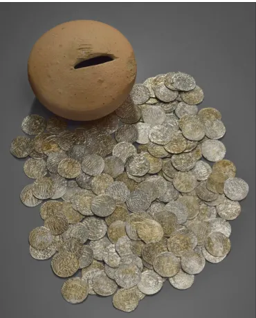
was likely the floor level of the house. There, we found a ceramic moneybox filled with coins (Fig.
5). Thanks to the highly skilled conservators, it was possible to remove the coins without damaging the container. This find, containing 318 coins, begins with 14 denarii from the early 15th century struck in Aquileia and ends with coins of Vladislaus II from the early 16th century. Most of the coins were minted during the reign of Matthias Corvinus. Fol- lowing its destruction in the early 16th century, the building was rebuilt and continued to be used. The oven by the western entrance was presumably only built at this point.
South of this building stood another late medieval house (Fig. 2). However, the basement walls of the modern-period hospital building were constructed on top of the walls of this house, thus we have less information about it. The house was built parallel to the street, so its orientation does not match that of the other medieval house, but rather of the Roman stone walls. Its north-south length is at least 15 m and its east-west width is 6.5 m. The northern part of the house had a cellar, which contained a thick red destruction layer.
The houses on the eastern side of the street had wells. We unearthed two wells on the bank of the
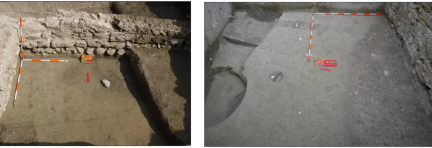
Danube, which were built using flat, chopped stones surrounded by a filtration layer with pebbles. The inner diameter of the southern well varies between 110 and 150 cm, and the bottom of the well – 4.5 m deep – had gravelling (Fig. 6). The northern well is slightly oval, and its greatest inner diameter is 170 cm. The bottom of this 3 m deep well was covered with flagstones (Fig. 7). The fill of both wells con- tained rich late medieval finds. Surprisingly, we also found the complete skeleton of a horse at the bottom of the narrower well. There was a thick medieval refuse layer that filled two large pits on the bank of the Danube.
The 15th–16th-century house, which survived in good condition, was built on top of the demolished
Fig. 5. Pottery moneybox from the floor of the late medieval house’s basement with coins from the reign of Matthias
Corvinus (photograph by Bence Tihanyi)
Fig. 6. Medieval well during excavation
(photograph by Péter Komjáthy) Fig. 7. Medieval well
(photograph by Péter Komjáthy)
and levelled remains of an earlier, late medieval building, with the walls of the new building erected partly on top of and partly next to the older struc- ture (Fig. 8). Although according to medieval doc- uments the area saw intensive use as early as the Árpád period, we only know of one feature from this era. However, we do have significant finds from the layer of that same period. We found a ditch run- ning east-west between the two-storey late medie- val house and its well, where we discovered a light green glazed aquamanile fragment, among other household pottery.
ROMAN-PERIOD SETTLEMENT TRACES
The medieval building in the middle of the present-day hospital courtyard was built inside a Roman stone building of 15 m × 15 m, with the parts that lay on the site of the house having been completely demolished (Figs 1–2). There is no doubt that its stones reused for the construction of the new building. In the other parts, the ancient walls were retained, but passages were cut through them. Based on the finds, the Roman building was used during the 2nd–3rd century. However, due to the later use of the area we have no data regarding the building’s function or interior divisions. The Roman wall is 60 cm wide, and built partially in opus spicatum (Fig. 9). There may have also been buildings with stone foundations standing next to this Roman building, but the only remnants of these are the bottom courses of stone or the debris from these courses left when they were carried away by floods.
In the western and south-western part of the present-day hospital courtyard we found earlier features dug into the ground, such as ditches, pits and postholes (Fig. 2). Below the medieval road and the traces of Roman stone construction, a 4.70 m long, 3.50 m wide pit house (?) came to light, in which we uncov- ered parts of a horse (?) skeleton, an early jug with red slip and a 1st-century fibula. In the southern part of the present-day courtyard, which was a slightly elevated part of the original terrain, we found a 34 m long stretch of a 2 m wide ditch, or more precisely, its trough-shaped, flat bottom, below the medieval and modern-period structures (Fig. 10). North of this, we uncovered a part of large pit. The pit’s function is unknown, as most of it was destroyed by the construction of the modern-period hospital wall. Finds from these features are few but highly characteristic, including the latest vessels of the native local Celtic popula- tion and the very high quality – in all likelihood imported – items of the Roman conquerors (a Loeschke I/B lamp depicting a pair of gladiators, an early cicada fibula, terra sigillata from southern Gaul and a Dressel 2–4 wine amphora). The features are also dated by an early coin (of Tiberius or Claudius?).
Fig. 8. Earlier medieval wall remains below the house from the Late Middle Ages (photograph by Gabriella Fényes)
Fig. 10. 1st-century features during excavation (photograph by Gabriella Fényes) Fig. 9. Roman walls around the medieval building
(photograph by Gabriella Fényes)
THE SITE WITHIN THE MEDIEVAL TOPOGRAPHY
Based on previous research, Gézavására was likely located around what is now the Buda end of the Marga- ret Bridge. King Géza II, in a document issued in 1148 that only survives in a 1253 transcription (MDCBP I. 3. 1., MNL DL 105992), granted the town toll of Gézavására to the provostrys of Buda, along with the customs of the ports of Pest and Kerepes as well as dock fees, and confirmed the fishing rights on the Dan- ube between the Megyer and Nagy (Csepel) Islands, which had been granted by King Ladislaus the Saint (Kubinyi 1964, 87–89, Magyar 1991, 156, for the problems of identification: Végh 2006, 23–24).
The area called Hévíz (‘Thermal waters’), named after the thermal springs around the present-day Lukács and Császár baths, was originally home to people in the service of the royal court of Buda. Change came during the late 12th century, when, in 1187, Pope Urban III approved the Hospitaller order of the Stephanites established by King Géza II in Jerusalem and confirmed their privileges, including the Church of the Holy Trinity in Hévíz donated by King Béla III to the crusaders. By 1211, Hévíz was independent from Buda. Its territory to the north reached the first milestone south of the Aquincum legionary fortress.
To the south, the northern two-thirds of the Castle Hill was also under the authority of the Felhévíz church prior to the Mongol invasion (Végh 2006, 22–24). These borders changed later on, with its northern border then extending to the mills operating alongside the thermal springs, including the mills and baths there in its territory, and its southern border reached the line of present-day Bem József Street (Kubinyi 1964, 142–148). There were baths and mills to the north, in the immediate vicinity of Malom-tó (‘Mill Lake’) and the present-day Lukács and Császár baths. The king, the Buda Chapter and the Óbuda and island nuns also owned mills there (Kubinyi 1964, 129–137). These mills were especially important sources of revenue for
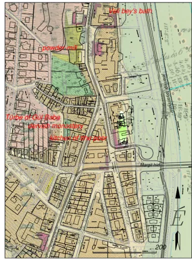
Fig. 12. The excavation site and its surroundings with the Ottoman-period topography superimposed on László Vörös’s
Topographical and Hydrographical Map of Buda and Pest (drawing by Zsolt Viemann)
Fig. 11. The excavation site and its surroundings with the medieval topography superimposed on László Vörös’s Topographical and Hydrographical Map of Buda and Pest
(drawing by Zsolt Viemann)
their proprietors, since they could also be used during the winter due to the thermal springs. The mills were likely located in the area of the later powder-mill (PaPP 2015, 108). We must also mention the Holy Spirit hospital, which was also founded here because of the thermal baths. Based on the cemetery found during the 2008 excavation to the east of the Ottoman-period Veli bey baths (PaPP 2008, 158, 48), the hospital likely stood south of the Császár baths, stretching towards the Danube (PaPP 2015, 106).
During the construction work by the Hospitaller Order of Saint John of God in 1906, the walls of the Church of the Holy Trinity were discovered 2 m below the contemporary surface. Construction was already underway at 5 Margit Boulevard, so there was no possibility for an excavation and it was only possible to document the remains (éber 1906, SuPKa 1907). The church had already existed before the Stephanites, who can be traced here until 1439. In 1445, it became a collegiate church (Kubinyi 1964, 115–121, bor-
oViczény 1991–1992, roMhányi 2000, 31). The connected chapter row was likely on present-day Török Street (Kubinyi 1964, 148). North of the church lay a walled cemetery, and to the north-northwest of this, there were butchers. An important Danube crossing, the Jenő ferry, was located between Üstökös and Vidra Streets. The port was likely further north, as its archaeological traces did not come to light during our excavation. The sources further mention a dunghill along which Pest boatmen could dock. This was likely south of the Margaret Bridge, around present-day Bodrog Street (Kubinyi 1964, 109–110, 148). In order to understand the medieval topography of the area, one must bear in mind that the course of the Danube in this period also included what is now approximately the line of the Árpád Fejedelem Road (Fig. 11).
During Ottoman occupation, a quarter similar to the Tabán settlement also developed around the upper thermal springs (FeKete 1944, 95–97). The most important building there was the powder-mill built by either Arslan pasha or Sokullu Mustafa pasha not long after the mid-16th century (PaPP 2015). This building was called Baruthane in Turkish, and the name was applied to the quarter as well. Next to the powder-mill stood the mosque of Sokullu Mustafa (Sudár 2014, 225–226). In 1578, Sokullu Mustafa pasha built baths north of the powder-mill, which were surprisingly named not after the builder, but instead called Veli bey’s baths (PaPP 2008, 85). The Türbe of Gül Baba built nearby in the 16th century still stands today. It is one
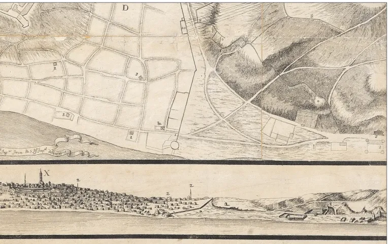
Fig. 13. Detail of Nikolas Marcel de La Vigne’s 1686 map of Buda and Pest
of the most important Ottoman sites in Budapest (ágoSton & Sudár 2002, 71–74). At the corner of Török Street and Gül Baba Street stood the Gül Baba dervish monastery, which had a kitchen for the poor in a sep- arate building, likely on a small square at the intersection of Török Street and Frankel Leó Street (identified by Balázs Sudár, Fig. 12). We do not know how far south the Ottoman-period settlement extended along the Danube, as its traces were likely destroyed by the sieges of 1598 and 1602–1603 (FeKete 1944, 33–40).
The 1684 Hallart-Wening engraving (rózSa 1963, Cat. 78, buda 2015, map C.6.3) shows a cemetery in the area around our excavation site, and buildings are not seen on engravings from 1686 either (see e.g. 1686 panorama by De la Vigne, Fig 13: rózSa 1963, Cat. 21,88,98, buda 2015, map C.5.1).
THE SITE IN THE ROMAN-PERIOD TOPOGRAPHY
The courtyard of the Buda Hospital of the Hospitaller Order of Saint John of God lies around 2.8 km south of the Aquincum legionary fortress and approximately 650 m north of the supposed site of the early ala base (Kérdő 2003, 81–82) (Fig. 14). Nearby, at the Frankel
Leó Street end of Török Street, a sarcophagus with rich grave goods was found during sewer construction in 1880. A Roman road was also reportedly observed next to the coffin, below the horse tramway rails (haM-
Pel 1881, 136–142). Roman settlement features, a section of a stone building and a well, were unearthed at 30–34 Frankel Leó Street (FacSády 1994a, 34. No 50/1).1 Several Roman graves and tombstones are known from both sides of the present-day street.
We have no direct evidence concerning the use of the springs of the nearby Lukács and Császár baths in antiquity, but it may be suspected based on altars.
In 1479, an Italian humanist made a drawing in front of the Church of the Holy Trinity to the south- west of the excavation site, described above, of an altar dedicated to the nymphs by Marcus Foviacius Verus (CIL III 3488, TitAq 291). Felice Feliciano also recorded that King Matthias had stones of the same kind with a similar inscriptions taken from here to the Buda castle (ritoóKné Szalay 1983, 72–73; ritoóKné Szalay 1994, 319, Fig 1, 321).
Altars dedicated to Jupiter Optimus Maximus and Silvanus were found on the grounds of and around the Lukács and Császár baths (CIL III 10419, TitAq 117; CIL III 3461, TitAq 162; TitAq 298). It was common custom in the Roman Empire to dedicate altars to gods and nymphs near medicinal waters to express one’s gratitude. Therefore, the springs were presumably already being used in the Roman period.
This is also suggested by the fact that during the lat- est excavation at the Császár baths, two walls from prior to the Middle Ages were also uncovered,2 and a layer containing Roman finds was also observed in
1 1992 excavation by Annamária R. Facsády (BHM Archaeological Archives cat. no. 1708-93).
2 Adrienn Papp, personal communication, 10 December 2019.
Fig. 14. The excavation site in the courtyard of the Buda Hospital of the Hospitaller Order of Saint John of God
with the Roman-period topography (drawing by Krisztián Kolozsvári)
1992 below the demolished large pool of the Császár baths (FacSády 1994b, 84, Nr. 121/6).3 Previously, a late Roman watchtower had been suspected to have been on the grounds of the Lukács baths (néMeth 2002, 97), but the remains proved to be from an Ottoman-period powder tower (Varga 2011, 119).
It can be seen from the present archaeological data that this area near thermal springs on the bank of the Danube, and which in all likelihood was suitable for use as a harbour and for ferries even in the Roman period, was already inhabited by the middle of the 1st century CE. The area also saw significant construc- tion work during the 2nd and 3rd centuries, the remains of which have been brought to light by our excava- tion in the courtyard of the Hospital of the Hospitaller Order of Saint John of God.
abbreViationS
CIL: Corpus Inscriptionum Latinarum.
MDCBP I: Gyánky, D. & Gárdonyi, A. (eds.) (1936). Monumenta Diplomatica Civitatis Budapestinensis.
Tomus I. (1148‒1301). Budapest.
MNL DL: Photo Collection of Medieval Charters of the Hungarian National Archives.
TitAq: Kovács, P. & Szabó, Á. (eds.) (2009). Tituli Aquincenses. Vol. I. Budapest: Pytheas.
reFerenceS
Ágoston, G. & Sudár, B. (2002). Gül Baba és a magyarországi bektasi dervisek. Budapest: Terebess Kiadó.
Boroviczény, K. Gy. (1991‒1992). Cruciferi Sancti Regis Stefani. Tanulmányok a stefaniták, egy középkori magyar ispotályos rend történetéről. Orvostörténeti Közlemények 133‒140, 7‒48.
Éber, L. (1906). A budafelhévízi Szentháromság templom maradványai. Budapest Régiségei 9, 209–211.
Facsády, A. (1994a). Nr. 50/1, Frankel Leó u. 30‒34. Régészeti Füzetek 1 (46), 34.
Facsády, A. (1994b). Nr. 121/6, Frankel Leó u. 35. (Császárfürdő). Régészeti Füzetek 1 (46), 84.
Gyánky, D. & Gárdonyi, A. (eds.) (1936). Monumenta Diplomatica Civitatis Budapestinensis. Tomus I.
(1148‒1301). Budapest.
Hampel, J. (1881). Római sírok Pannoniában. Archaeologiai Értesítő Új évfolyam 1, 136‒146.
Kérdő, K. (2003). Das Alenlager und Vicus der Víziváros. In P. Zsidi (ed.), Forschungen in Aquincum 1969‒2002 (pp. 112‒119). Aquincum Nostrum II. 2. Budapest: Budapesti Történeti Múzeum.
Kovács, P. & Szabó, Á. (eds.) (2009). Tituli Aquincenses. Vol. I. Budapest: Pytheas.
Kubinyi, A. (1964). Budafelhévíz topográfiája. Tanulmányok Budapest Múltjából 16, 85‒170.
Magyar, K. (1991). Gründung Budas. In G. Biegel (ed.), Budapest im Mittelalter (pp. 153‒184).
Braunschweig: Braunschweigisches Landesmuseum.
3 1992 excavation by Annamária R. Facsády (BHM Archaeological Archives cat. no. 1723-93).
Németh, M. (2003). Wachtürme und Festungen am linken Donauufer. In P. Zsidi (ed.), Forschungen in Aquincum 1969‒2002 (pp. 96‒99). Aquincum Nostrum II. 2. Budapest: Budapesti Történeti Múzeum.
Papp, A. (2008). Budapest, II. Árpád fejedelem útja, Császár fürdő. In Kisfaludi, J. (ed.), Régészeti Kutatások Magyarországon 2008 (p. 158, 48. kat.). Budapest: Kulturális Örökségvédelmi Hivatal – Magyar Nemzeti Múzeum.
Papp, A. (2015). Török kori lőpormalom Budán. Keletkutatás 1, 105‒113.
Ritoókné Szalay, Á. (1983). Nympha super ripam Danubii. Irodalomtörténeti Közlemények 87, 67‒74.
Ritoókné Szalay, Á. (1994). A római föliratok gyűjtői Pannoniában. In Mikó Á. & Takács I. (ed.), Pannonia Regia. Művészet a Dunántúlon 1000‒1541 (pp. 318‒329). Budapest: Magyar Nemzeti Galéria.
Romhányi, B. (2000). Kolostorok és társaskáptalanok a középkori Magyarországon. Budapest: Pytheas.
Rózsa, Gy. (1963). Budapest régi látképei. Monumenta Historia Budapestinensia 2. Budapest: Akadémiai Kiadó.
Sudár, B. (2014). Dzsámik és mecsetek a hódolt Magyarországon. Budapest: MTA Bölcsészettudományi Kutatóközpont Történettudományi Intézet.
Supka, G. (1907). A budafelhévízi Szentháromság templom. Archaeologiai Értesítő 27, 97–119.
Varga, G. (2011). Római kori őrtornyok Budapesten. Archaeologiai Értesítő 136, 115‒134. http://dx.doi.
org/10.1556/ArchErt.136.2011.5
Végh, A. (2006). Buda város helyrajza 1. Monumenta Historia Budapestinensia 15. Budapest: Budapesti Történeti Múzeum – Archaeolingua.
Végh, A. (2015). Buda. I. kötet, 1686-ig. Magyar Várostörténeti Atlasz 4. Budapest: Budapesti Történeti Múzeum ‒ Pázmány Péter Katolikus Egyetem.