PIONEER LICHEN COMMUNITIES OF THE TETERIV RIVER BASIN (UKRAINE)
N. V. Kapets1, O. O. Barsukov1, D. S. Vynokurov1 and I. V. Khomyak2
1M. H. Kholodny Institute of Botany, 2 Tereshchenkivska Str., Kyiv, 01004 Ukraine E-mails: kapets_n@ukr.net, narak-zempo@yandex.ru
2Ivan Franko Zhytomyr State University, 40 Velyka Berdychivska Str., Zhytomyr 10008, Ukraine; E-mail: ecosystem_lab@ukr.net
(Received 23 March, 2018; Accepted 10 August, 2018)
The results of phytosociological studies of pioneer lichen communities of siliceous out- crops carried out in 2014–2016 in Teteriv River basin (Ukraine) are provided. The dataset of 302 relevés was analysed, 6 associations and 1 subassociation from 3 classes were dis- tinguished as a result of the phytosociological survey in the Teteriv River basin. Four asso- ciations, i.e.: Aspicilietum contortae Kaiser ex Klement 1955, Cladonietum mitis Krieger 1937, Parmelietum conspersae Hilitzer 1925, Parmelietum somloensis Wirth 1995 and the alliance Aspicilion calcareae Albertson ex Roux 1978 are new for Ukraine, and one new association Aspicilio cinerei-Ramalinetum pollinariae Kapets et Khomyak, ass. nova is described here.
Key words: Aspicilietum cinereae, Aspicilio cinerei-Ramalinetum pollinariae, Aspicilietum con- tortae, Cladonietum mitis, cryptogam communities, siliceous outcrops, syntaxonomy, Par- melietum conspersae, Parmelietum somloensis
INTRODUCTION
Lichens like the other cryptogams differ from vascular plants in many characteristics (poikilohydry, intensity of biochemical processes, rootless structure, etc.). Due to specific biological processes lichens can colonise ex- treme habitats that would be unsuitable for most vascular plants, thus form- ing a special type of vegetation. Cryptogamic communities can form special vegetation types and these can be classified as separate syntaxa. The study of lichen communities is one of the sources of additional information on habitats and monitoring changes therein (Bültman and Daniëls 2009, Paus 1997). It is extremely important to study habitats and biotopes with poor vascular plant vegetation (siliceous screes and rocky slopes, 8150 (Medio-European upland siliceous screes), 8220 (siliceous rocky slopes with chasmophytic vegetation), 8230 (siliceous rock with pioneer vegetation of the Sedo-Scleranthion Br.-Bl.
et Richard 1950 or of the Sedo albi-Veronicion dilleni Korneck 1974) according to the Directive 1992/43/EEC, etc.). Some types of these habitats are located in the Teteriv River basin. It should be noted that lichen communities of these habitats, unlike vascular plant vegetation, has never been studied in Ukraine.
The low degree of recovery is one of the features inherent to extreme rock habitats, which increases importance of studying changes therein. Some more detailed study covering all components of these habitats can help improving protection at the study area.
Lichen communities of Ukraine have hitherto been researched poorly.
Some information to this end was published first in the early 20th century.
The data on three epilithic lichen communities from central and northern Ukraine was published in 1927 by Oxner (1927). The author used an origi- nal method to find out the percentage cover of each species. The studies of epilithic, epiphytic and epigeic lichen communities of central Ukraine us- ing Braun-Blanquet method were carried out in the first half of the 20th cen- tury. These data are also included in ‘Prodromus der mitteleuropäischen Flechtengesellschaften’ (Klement 1955). Some peculiar vegetation studies on cryptogamic communities have been carried out in various parts of Ukraine (Crimea Peninsula, steppe zone and forest-steppe zone) at the beginning of the 21st century (Gapon 2013, Khodosovtsev 2015, Khodosovtsev et al. 2011, 2014, Redchenko 2004).
The objective of this research was to investigate the syntaxonomic struc- ture of the pioneer lichen communities of siliceous outcrops in the Teteriv Riv- er basin (Ukraine). This information will not merely provide intimate knowl- edge covering syntaxonomy of the pioneer vegetation on the siliceous screes and rocky slopes, but it will also be interesting for further syntaxonomic re- search of the lichen communities of Ukraine. More detailed study covering this type of habitats will facilitate development of an efficient conservation system to be applied at this territory.
MATERIAL AND METHODS Study area
Geographic position. The Teteriv River flows in the north of Ukraine and flows into the Dnieper River. The total length of the river is 365 km, the aver- age velocity ranging from 0.3–0.5 m/s to 1.0–2.5 m/s at rock ledges. The Teteriv River basin is located in the northwestern part of the Ukrainian Crystal Shield, covering the area of 15,100 km2. The Hnylopiat, Huyva, Irsha and Zdvyzh Rivers are the major tributaries of the Teteriv River. The rivers’ banks in the basin are normally steep, 1–2 m high, often with outcrops forming riverside rocks. The major type of the area landscape is outwash plains resting on crys- talline basement. The major types of soils are turf-podzolic, turf-podzol, black and forest soils. The outcrops form rock ledges, riverside rocks, and some- times even canyons of 25 to 30 m wide (Fig. 1). The crystalline rocks are rep- resented by granitoids of the Kirovohrad-Zhytomyr and the Korosten intru-
sive sheets. Most of the exposures are located at the upper and middle course of the Teteriv River basin. Therefore, these sections are the most suitable for studying epilithic lichen communities (Marinich 1963, Marinich et al. 1985).
Vegetation and climate. Some portions of the Teteriv River basin’s upper course are located at the forest-steppe zone of Ukraine. The middle and lower course of the basin are located at the forest zone. More than half of the area is covered with forest vegetation, as represented by three major types: acido- philous beech and mixed fir-beech forests (ass. Ficario vernae-Ulmetum cam- pestris Knapp ex Medwecka-Kornaś, Tilio cordatae-Carpinetum betuli Traczyk 1962, Poo nemoralis-Tilietum cordatae Firbas et Sigmond 1928, Potentillo albae- Quercetum Libb. 1933); acidophilous oak and oak-birch forests on nutrient- poor soils (ass. Trientalo europaeae-Quercetum roboris Vorobyov 2014) and pine forests on nutrient-poor and hydromorphic soils (ass. Dicrano-Pinetum Prei sing et Knapp ex Oberd. 1957, Molinio-Pinetum Matuszkiewicz (1973) 1981, Peucedano-Pinetum Mat. (1962) 1973, Vaccinio uliginosi-Pinetum de Kleist 1929). Mesotrophic regularly flooded alder (ass. Ribo nigri-Alnetum Solińska- Górnicka 1975, Sphagno squarrosi-Alnetum Sol.-Gorn. (1975) 1987) and willow carrs (ass. Salicetum pentandro-cinereae Pass. 1961) are frequent in floodplains (Didukh et al. 2011, Orlov and Yakushenko 2005).
The geomorphological features of this area facilitated forming special types of vegetation. The chasmophytic vegetation of crevices, rocky ledges and faces of rocky cliffs (ass. Hypno-Polypodietum Jurko et Peciar 1963, Asple- nio-Cystopteridetum fragilis Oberd. (1936) 1949, etc.) and pioneer vegetation on shallow soils on rocky siliceous rocks (ass. Melico transsylvanicae-Sedetum ru- prechtii Kontar 1998, Thymo pulegioidis-Sedetum sexangularis Didukh et Kontar 1998 (Didukh et al. 2011) are some of them.
The climate of the Teteriv River basin is temperate continental, with increasing continentality from the northwest to the southeast. The average annual temperature is +6 °С to +7 °С. The average temperature is +19.4 °С in July, and –5.7 °С in January. The average annual amount of precipitation reaches about 562 mm.
Research methods
A total of 302 phytosociological relevés had been collected in 2014–2016.
The vast majority of relevés were done on lichen-rich outcrops, and a few rel- evés on sandy areas near the outcrops. The phytosociological relevé sampling procedure followed the Braun-Blanquet approach (Braun-Blanquet 1964, Mir- kin and Rozenberg 1983). Some guidelines on selecting relevés plots of epilith- ic lichen communities, as proposed by Klement (1955), were also considered.
The relevés include lichens, bryophytes and some epilithic fungi of the genus
Lichenothelia D. Hawksw. The lichens and bryophytes were identified accord- ing to the standard techniques and using light microscopy (Kondratyuk and Martynenko 2006). The analysis of some ecological characteristics (pH of the substratum, light, xerophytism) was completed relying on scales proposed by Nimis and Martellos (2008), and by Wirth (2010).
The relevés were stored in the Turboveg 2.0 database (Hennekens 2009).
The analysis of lichen communities was completed with the Juice 7.0 software package (Tichý 2002) using Two-way indicator species analysis (Twinspan) (Hill 1979) with the following default parameters: 3 pseudospecies cut levels:
0%, 5%, 25%; minimum group size – 5; maximum level of division – 6. The phi fidelity index was used to identify diagnostic species (Chytrý et al. 2002).
We considered diagnostic species with phi > 25%, constant species with fre- quencies > 25%, dominant species with a mean cover of more than 10% and minimum frequency 10%. The names of syntaxa were specified according to the third edition of the International Code of Phytosociological Nomenclature (Weber et al. 2000). The names of the high level syntaxa were disclosed accord- ing to the modern European hierarchical system of classification of vascular plants, bryophytes, lichens and algae (Mucina et al. 2016). Species names are given according to the ‘Index Fungorum’ for lichens (CABI 2018), and accord- ing to Boiko (2008, 2014) for bryophytes.
RESULTS
The pioneer communities of the study area are represented by six as- sociations, one subassociation of three alliances and three classes. As a result of the syntaxonomic interpretation of phytosociological data, the following chart of the pioneer lichen communities of the Teteriv River basin was created.
Cl. Rhizocarpetea geographici Wirth 1972 Ord. Rhizocarpetalia Klement 1949
All. Parmelion conspersae Hadaс in Klika et Hadaс 1944 Aspicilietum cinereae Frey 1922
Parmelietum conspersae Hilitzer 1925 Parmelietum somloensis Wirth 1995
Aspicilio cinerei-Ramalinetum pollinariae Kapets et Khomyak in Kapets et al.
2018 (this paper) Cl. Verrucarietea nigrescentis Wirth 1980
Ord. Verrucarietalia nigrescentis Klement 1950 All. Aspicilion calcareae Albertson ex Roux 1978 Aspicilietum contortae Kaiser ex Klement 1955 Cl. Ceratodonto purpurei-Polytrichetea piliferi Mohan 1978
Ord. Peltigeretalia Klement 1949
All. Cladonion arbusculae Klement 1949 Cladonietum mitis Krieger 1937
Characteristics of the associations
Ass. Aspicilio cinerei-Ramalinetum pollinariae Kapets et Khomyak, ass. nova, hoc loco
Holotypus hoc loco: Table 1, relevé № 6 (Zhytomyr Oblast, Korostyshiv Rayon, the north- east outskirts of Horodske village, the right bank of the Teteriv River, outcrops, 50° 22’
26.5” N, 29° 10’ 53.3” E, alt. 175 m a.s.l.; Sampled by N. Kapets on 8 August 2016).
Diagnostic species: Aspicilia cinerea, Ramalina pollinaria.
Constant species: Ramalina pollinaria, Candelariella vitellina.
Dominant species: Ramalina pollinaria, Aspicilia cinerea, Protoparmeliopsis muralis, Physcia dubia, Rhizocarpon eupetraeum.
The association of epilithic lichens is found in the Ukrainian Crystal Shield’s outcrops (Fig. 2). This community occurs on inclined, almost vertical and perched surfaces mainly of the northern and northwest exposures. The average number of species per relevé is 7.7. The community characterised by a high total cryptogam layer cover consisted of 40–60%, with a significant pro- portion of the substrate surface remaining bare. The cover of lichens ranged from 40 to 90%. The bryophytes are not always present and their cover usually does not exceed 20%. The minimum range of the association is 30 cm2. Rather acidophytic, mesophytic moderately photophytic, usually occurred in sun-ex- posed sites without extreme solar irradiation. The characteristic feature of com- munities of this association is presence of fruticose lichen Ramalina pollinaria in the species composition (cover up to 20–75%). This association was described on mesophilous damp and shaded vertical or perched surfaces of outcrops.
Ass. Aspicilietum cinereae Frey 1922
Syn.: Aspicilia gibbosa-Ges. Mattick 1937, Lecanoretum sordidae Hilitzer 1936, Candelarilletum vitellinae Motyka 1925, Lecanora polytropa-Ges. Mattick 1937, Aspicilia cinerea-Ass.
Hilitzer 1927.
Diagnostic species: Aspicilia cinerea, Circinaria caesiocinerea, Circinaria gib- bosa, Lecanora rupicola.
Constant species: Acarospora fuscata, Aspicilia cinerea, Candelariella vitel- lina, Lecidea fuscoatra, Polysporina simplex, Protoparmeliopsis muralis.
Dominant species: Acarospora fuscata, Aspicilia cinerea, Candelariella vitel- lina, Lecidea fuscoatra, Polysporina simplex, Protoparmeliopsis muralis.
The boreal-Mediterranean, high-altitude association of epilithic lichens on well-illuminated, nutrient-rich, igneous rocks (Fig. 3). The average number of species per relevé is 9.3. The community characterised by a high total cryp- togam layer cover consisted of 80–98% (Table 2). The cover of lichens ranged from 70 to 99%. The bryophytes occurred rarely and had an insignificant cov-
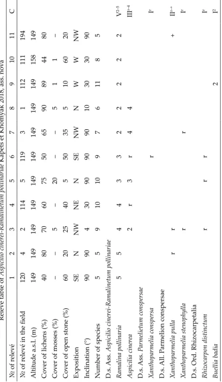
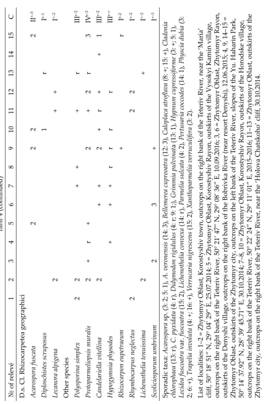
Table 1 Relevé table of Aspicilio cinerei-Ramalinetum pollinariae Kapets et Khomyak 2018, ass. nova № of relevé1234567891011C № of relevé in the field12042114511931112111194 Altitude a.s.l. (m)149149149149149149149149149158149 Cover of lichens (%)4080706075506590894480 Cover of mosses (%)––5–20––511– Cover of open stone (%)60202540550355106020 ExpositionSENNWNENSENWNWWNW Inclination (°)909043090909010303090 Number of species55910109761185 D.s. Ass. Aspicilio cinerei-Ramalinetum pollinariae Ramalina pollinaria55443322222V2–5 Aspicilia cinerea2r3r44IIIr–4 D.s. Ass. Parmelietum conspersae Xanthoparmelia conspersarIr D.s. All. Parmelion conspersae Xanthoparmelia pullarr+IIr–+ Xanthoparmelia stenophyllarrIr D.s. Ord. Rhizocarpetalia Rhizocarpon distinctumrrrIr Buellia badia2I2
Table 1 (continued) № of relevé1234567891011C D.s. Cl. Rhizocarpetea geographici Acarospora fuscatarr+IIr–+ Diploschistes scruposus3I3 Lecanora alpigena rIr Other species Candelariella vitellinarrr2rrrIVr–2 Polysporina simplex222+2III+–2 Protoparmeliopsis muralisr2232IIIr–3 Lichenothelia tenuissima21I1–2 Pertusaria coccodes2I2 Acarospora veronensis+2+++III+–2 Physcia dubia233III2–3 Rhizocarpon eupetraeum22I2 Hypocenomyce scalaris2I2 Grimmia pulvinata2rIr–2 Pertusaria sp.rr+IIr–+ Grimmia muehlenbeckiirrrIIr Hypnum cupressiformerrrrIIr Scoliciosporum umbrinum2+I+–2 Sporadic taxa: Cladonia sp. (6: r; 9–10: +), Lichenothelia convexa (6: +), Lepraria incana (11: +), Lepraria membranacea (5: r), Rhymbocar- pus neglectus (5: +), Xanthoparmelia sp. (4: +; 9: +).
List of localities: 1–10 = Zhytomyr Oblast, Korostyshiv Rayon, outskirts of the Horodske village, outcrops on the right bank of the T
eteriv River; 11 = Zhytomyr Oblast, Zhytomyr Rayon, outskirts of the Denyshi village, outcrops on the right bank of the Bobrivka River (near resort Denyshi), 12.06.2015.
er. Rather subneutrophytic to subacidic, mesophytic, moderately photophyt- ic, usually occurred in sun-exposed sites without extreme solar irradiation.
The characteristic feature of communities of this association is predominance of crustose lichens, such as Acarospora fuscata, Aspicilia cinerea, Candelariella vitellina and Lecidea fuscoatra. The cover of foliose lichens on most of studied sites was very low, under 30%. It is distributed on surfaces of different steep- ness and exposition. The association is fairly homogeneous, subassociations are not known.
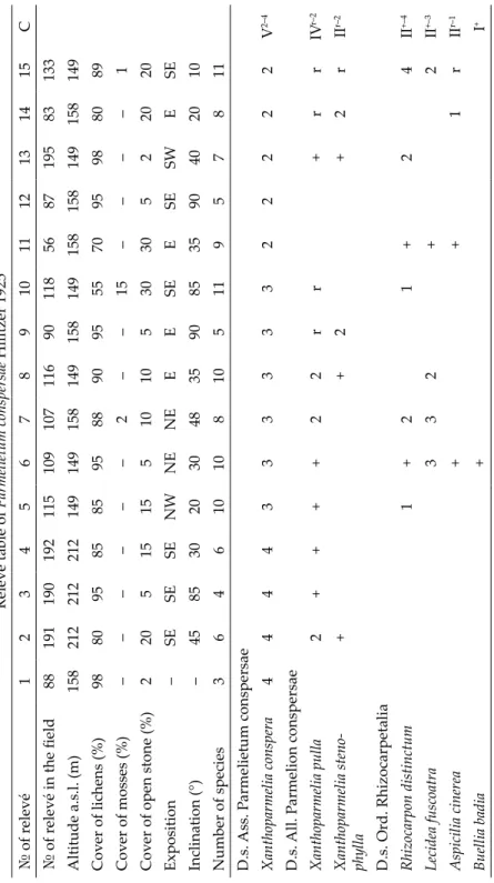
Ass. Parmelietum conspersae Hilitzer 1925
Diagnostic species: Xanthoparmelia conspersa.Constant species: Xanthoparmelia conspera, Xanthoparmelia pulla.
Dominant species: Xanthoparmelia conspera, Lecidea fuscoatra, Protoparme- liopsis muralis, Rhizocarpon distinctum.
Fig. 2. The association Aspicilio cinerei-Rama- linetum pollinariae Kapets et Khomyak 2018
Fig. 3. The association Aspicilietum cinereae Frey 1922
Fig. 1. Granite outcrops in the Teteriv River valley
Fig. 4. The association Parmelietum somloen- sis Wirth 1995
The boreal-Mediterranean, subcontinental association of epilithic lichens on well-illuminated, nutrient-rich, igneous rocks. The average number of spe- cies per relevé is 7.4. The association characterised by a high total cryptogam layer cover consisted of 70–98% (Table 3). The lichens cover ranged up 70 to 98%. The cover of bryophytes does not exceed 2–30%. The minimal area of the community is 30 cm2. Rather acidophytic, mesophytic, usually occurred in sun-exposed sites without extreme solar irradiation. It is distributed on surfaces of different steepness and exposition.
Ass. Parmelietum somloensis V. Wirth 1995
Syn.: Parmelietum molliusculae Gams 1927, Parmelietum stenophyllae Gams ex Klem. 1955, Parmelietum taracticae Klem. 1955.
Diagnostic species: Xanthoparmelia stenophylla.
Constant species: Xanthoparmelia stenophylla, Xanthoparmelia conspersa, Protoparmeliopsis muralis.
Dominant species: Sarcogyne simplex, Xanthoparmelia stenophylla.
The boreal-Mediterranean, subcontinental association of epilithic lichens on well-illuminated, nutrient-rich, igneous rocks (Fig. 4). The average number of species per relevé is 7.5. The total cryptogamic layer cover was high and consisted of 70–98% (Table 4). The lichen cover constituted 80–95%, the cover of bryophytes does not exceed 10%. Subacidophytic to subneutrophytic, mostly mesophytic, usually occurred in sun-exposed sites without extreme solar ir- radiation. The community was common on partially shaded outcrops. The as- sociation is quite variable. Our research resulted in identifying subassociation Parmelietum somloensis var. Xanthoparmelia pulla. The subassociation is different due to availability of the foliose lichen Xanthoparmelia pulla. Communities of the association are distributed on surfaces of different steepness and exposition.
Ass. Aspicilietum contortae Kaiser ex Klement 1955
Diagnostic species: Aspicilia contorta.Constant species: Aspicilia contorta, Candelariella vitellina, Protoparmeliop- sis muralis, Sarcogyne simplex.
Dominant species: Aspicilia contorta, Bellemerea cupreoatra, Caloplaca atro- flava, Candelariella vitellina, Endocarpon trachyticum, Protoparmeliopsis muralis, Sarcogyne simplex, Acarospora sp., Verrucaria nigrescens.
The subboreal, European-Mediterranean association of epilithic lichens on calcareous rocks. The average number of species per relevé is 8.2. The as- sociation characterised by a high total cryptogamic layer cover ranged from 65 to 90% (Table 5). Bryophytes are not always present, only three species hav-
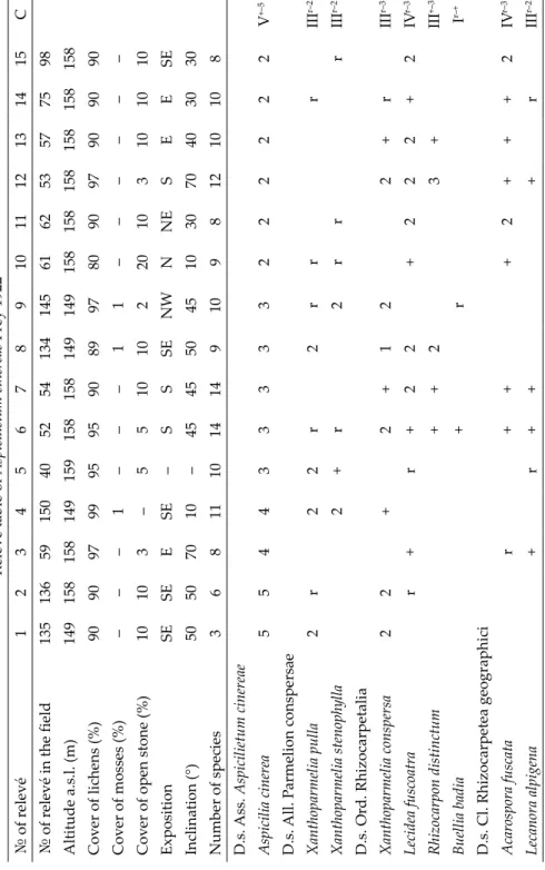
Table 2 Relevé table of Aspicilietum cinereae Frey 1922 № of relevé123456789101112131415C № of relevé in the field13513659150405254134145616253577598 Altitude a.s.l. (m)149158158149159158158149149158158158158158158 Cover of lichens (%)909097999595908997809097909090 Cover of mosses (%)–––1–––11–––––– Cover of open stone (%)10103–551010220103101010 ExpositionSESEESE–SSSENWNNESEESE Inclination (°)50507010–45455045103070403030 Number of species36811101414910981210108 D.s. Ass. Aspicilietum cinereae Aspicilia cinerea554433333222222V+–5 D.s. All. Parmelion conspersae Xanthoparmelia pulla2r22r2rrrIIIr–2 Xanthoparmelia stenophylla2+r2rrrIIIr–2 D.s. Ord. Rhizocarpetalia Xanthoparmelia conspersa22+2+122+rIIIr–3 Lecidea fuscoatrar+r+22+222+2IVr–3 Rhizocarpon distinctum++23+III+–3 Buellia badia+rIr–+ D.s. Cl. Rhizocarpetea geographici Acarospora fuscatar+++2+++2IVr–3 Lecanora alpigena+r+++rIIIr–2
Table 2 (continued) № of relevé123456789101112131415C Other species Candelariella vitellina+332rr222+22Vr–3 Polysporina simplex222++2+2r2+Vr–2 Protoparmeliopsis muralis+223123+323IV+–3 Lichenothelia tenuissima+r2+++rIIIr–2 Acarospora sp.++++r+2rIIIr–3 Fuscidea lygaea++r+IIr–+ Rhizocarpon eupetraeumrIr–3 Scoliciosporum umbrinum+I+–2 Parmelia sulcata2Ir–2 Hypogymnia physodesrIr Grimmia muehlenbeckii111I1 Lepraria incana2rIr–2 Sporadic taxa: Caloplaca atroflava (2: r), Lepraria membranacea (8: r), Myriolecis dispersa (2: r), Rhymbocarpus neglectus (8: r), Xan- thoparmelia sp. (4: +). List of localities: 3, 5–7, 10–13 = Zhytomyr Oblast, Korostyshiv town, outcrops on the right bank of the Teteriv River, near the
‘Maria’ cliff, 50° 08’ 51” N, 29° 04’ 29” E, 25.07.2014; 1–2, 4, 8–9 = Zhytomyr Oblast, Korostyshiv Rayon, outskirts of the Horodske village, outcrops on the right bank of the T
eteriv River, 50° 22’ 23” N, 29° 11’ 01” E, 5.06.2015; 14, 15 = Zhytomyr Oblast, outskirts of the Zhytomyr city, outcrops on the right bank of the Teteriv River, near the ‘Holova Chatskoho’ cliff, 30.10.2014.
Table 3 Relevé table of Parmelietum conspersae Hilitzer 1925 № of relevé123456789101112131415C № of relevé in the field8819119019211510910711690118568719583133 Altitude a.s.l. (m)158212212212149149158149158149158158149158149 Cover of lichens (%)988095858595889095557095988089 Cover of mosses (%)––––––2––15––––1 Cover of open stone (%)220515155101053030522020 Exposition–SESESENWNENEEESEESESWESE Inclination (°)–4585302030483590853590402010 Number of species36461010810511957811 D.s. Ass. Parmelietum conspersae Xanthoparmelia conspera444433333322222V2–4 D.s. All. Parmelion conspersae Xanthoparmelia pulla2++++22rr+rrIVr–2 Xanthoparmelia steno- phylla++2+2rIIr–2 D.s. Ord. Rhizocarpetalia Rhizocarpon distinctum1+21+24II+–4 Lecidea fuscoatra332+2II+–3 Aspicilia cinerea++1rIIr–1 Buellia badia+I+
Table 3 (continued) № of relevé123456789101112131415C D.s. Cl. Rhizocarpetea geographici Acarospora fuscata2+2I+–2 Diploschistes scruposus+2Ir–2 Other species Protoparmeliopsis muralis322323+++rIV+–3 Polysporina simplex232+++2+III+–3 Candelariella vitellinarrr+rIIr–+ Lichenothelia tenuissima+++++II+–2 Parmelia sulcata2++rII+–1 Lichenothelia convexa+++1I+ Acarospora veronensis++++II+–4 Rhymbocarpus neglectus+32Ir–3 Sporadic taxa: Cladonia chlorophaea (1: 2; 12: 2; 13: r), C. pyxidata (10: +), Didymodon rigidulus (7: +), Grimmia muehlenbeckii (15: r), Hypogymnia physodes (10: 2), Lepraria incana (2: +), Pertusaria coccodes (10: 1), Ramalina pollinaria (5: r; 10: r), Rinodina teichophila (15: r), Scoliciosporum umbrinum (3: 2; 4: 2). List of localities: 1, 12–14 = Zhytomyr Oblast, Korostyshiv town, outcrops on the right bank of the Teteriv River, near the ‘Ma-
ria’ cliff, 50° 18’ 51” N, 29° 04’ 29” E, 25.07.2014; 2–4, 15 = Zhytomyr Oblast, Zhytomyr Rayon, outskirts of the Denyshi village, outcrops on the right bank of the Bobrivka Riv
er (near resort Denyshi), 12.06.2015; 5–6, 8, 10–11 = Zhytomyr Oblast, Korostyshiv Rayon, outskirts of the Horodske village, outcrops on the right bank of the Teteriv River, 50° 22’ 23” N, 29° 11’ 01” E, 5.06.2015; 7, 9 = Zhytomyr Oblast, outskirts of the Korostyshiv town, outcrops on the right bank of the Teteriv River, 50° 20’ 16.82” N, 29° 04’ 29.49” E, 30.10.2015.
Table 4 Relevé table of Parmelietum somloensis V. Wirth 1995 № of relevé123456789101112131415C № of relevé in the field8938192204210193138137202140959613032205 Altitude a.s.l. (m)158159212159159212149149154149158158149181154 Cover of lichens (%)999585808580907080909535709880 Cover of mosses (%)––21055––5––15––10 Cover of open stone (%)15131010151030151055030210 ExpositionSE–SESSWSESWSWSESWSESWSSE Inclination (°)90–8790903530303545802030425 Number of species498977661297101179 D.s. Ass. Parmelietum somloensis Xanthoparmelia stenophylla443224433222221V1–4 D.s. X. s. var. Xanthoparmelia pulla Xanthoparmelia pulla22+r4221++IVr–4 D.s. Ass. Parmelietum conspersae Xanthoparmelia conspersa2+++II+–2 D.s. Ord. Rhizocarpetalia Aspicilia cinerear+2++rIIr–2 Lecidea fuscoatrar+2++1+IIr–2 Buellia badia++++II+ Rhizocarpon distinctum232I2–3
Table 4 (continued) № of relevé123456789101112131415C D.s. Cl. Rhizocarpetea geographici Acarospora fuscata2222II+–3 Diploschistes scruposus1rIr–1 Lecanora alpigena2++I+–2 Other species Polysporina simplex22+++rIIIr–2 Protoparmeliopsis muralis2+r+2+2r3IVr–3 Candelariella vitellina2++2+r++1IIIr–2 Hypogymnia physodes+++rrrrIIIr–+ Rhizocarpon eupetraeum+rIr–2 Rhymbocarpus neglectus222I+–2 Lichenothelia tenuissima2+I+–2 Scoliciosporum umbrinum23+I+–3 Sporadic taxa: Acarospora sp. (3: 2; 5: 1), A. veronensis (14: 3), Bellemerea cupreoatra (12: 3), Caloplaca atroflava (8: +; 15: +), Cladonia chlorophaea (13: r), C. pyxidata (4: r), Didymodon rigidulus (4: r; 9: 1;), Grimmia pulvinata (13: 1), Hypnum cupressiforme (3: +; 5: 1), Lecidea fuscoatra var. fuscoatra (15: 2), Lichenothelia convexa (14: r), Parmelia sulcata (4: 2), Pertusaria coccodes (14: 1), Physcia dubia (3: 2; 6: +), Trapelia involuta (4: +; 16: +), Verrucaria nigrescens (15: 2), Xanthoparmelia verruculifera (3: 2). List of localities: 1–2 = Zhytomyr Oblast, Korostyshiv town, outcrops on the right bank of the Teteriv River, near the ‘Maria’
cliff, 50° 18’ 51” N, 29° 04’ 29” E, 25.07.2014; 5 = Zhytomyr Oblast, Korostyshiv Rayon, outskirts of the Vysokyi Kamin village, outcrops on the right bank of the T
eteriv River, 50° 21’ 47” N, 29° 08’ 36” E, 10.09.2016; 3, 6 = Zhytomyr Oblast, Zhytomyr Rayon, outskirts of the Denyshi village, outcrops on the right bank of the Bobrivka River (near resort Denyshi), 12.06.2015; 4, 9, 14–15 = Zhytomyr Oblast, outskirts of the Zhytomyr city, outcrops on the left bank of the Teteriv River, slopes of the Yu. Haharin Park,
50° 14’ 37.92” N, 28° 39’ 45.71” E, 30.10.2014; 7–8, 10 = Zhytomyr Oblast, Korostyshiv Rayon, outskirts of the Horodske village, outcrops on the right bank of the T
eteriv River, 50° 22’ 24” N, 29° 11’ 01” E, 2015–2016; 11–13 = Zhytomyr Oblast, outskirts of the Zhytomyr city, outcrops on the right bank of the Teteriv River, near the ‘Holova Chatskoho’ cliff, 30.10.2014.
Table 5 Relevé table of Aspicilietum contortae Kaiser ex Klement 1955 № of relevé123456789C № of relevé in the field2412421312111415243244 Altitude a.s.l. (m)180180181181181181181181181 Cover of lichens (%)859075707070906585 Cover of mosses (%)52––––––– Cover of open stone (%)10525303030103515 ExpositionSESSSWSWSWSWSS Inclination (°)355203030404535 Number of species998111091063 D.s. Ass. Aspicilietum contortae Circinaria contorta333222222V3–2 D.s. All. Aspicilion calcareae Circinaria calcarea2+II+–2 D.s. Cl. Verrucarietea nigrescentis Verrucaria nigrescens32++III+–3 Myriolecis dispersa++++2III+–2 Other species Candelariella vitellinarr22222r3Vr–3 Protoparmeliopsis muralisr2233223IVr–3 Acarospora sp.2212III1–2 Physcia caesia22+22III+–2 Bellemerea cupreoatra122+2III+–2
ing low coverage (not exceeding 5%) were identified. The total cryptogamic cover constituted 65–90%. The asso- ciation includes mainly crustose li- chens with grey, grey-black, black and brown slate. Rather subacidophytic to subneutrophytic, mesophytic to xero- phytic avoiding extremely arid stands, occurred in sun-exposed sites without extreme solar radiation. Association was found on labradorite and granite outcrops and distributed on surfaces of different steepness and exposition.
Ass. Cladonietum mitis Krieger 1937
Diagnostic species: Cladonia mitis, C. portentosa.Constant species: Cladonia chloro- phaea, C. furcata, C. portentosa, Peltigera malacea, Polytrichum piliferum.
Dominant species: Cladonia por- tentosa, C. furcata, Peltigera malacea, Pol- ytrichum piliferum.
The boreal-Mediterranean, sub- continental, photophilous, acidophil- ous, mesophytic association of epigeic Table 5 (continued) № of relevé123456789C Other species Caloplaca atroflava+233III+–3 Lichenothelia convexa++r++III+–r Sarcogyne simplexrr++1+IV+–1 Endocarpon trachyticum32+3III+–3 Sporadic taxa: Ceratodon purpureus (1: 2), Cladonia sp. (1–2: r), Hypnum cupressiforme (1: r), Syntrichia ruralis (2: 1). List of localities: 1–2, 8–9 = Zhytomyr Oblast, Korostyshiv Rayon, Kam’ianyi Brid village, outcrops on the left bank of the Bystri- ivka River, 50° 28’ 40” N, 28° 57’ 01” E, 08.09.2016; 50° 28’ 44” N, 28° 57’ 20” E, 08.09.2016; 3–7 = Zhytomyr Oblast, outskirts of the Zhytomyr city, outcrops on the left bank of the Teteriv River, slopes of the Yu. Haharin Park, 50° 14’ 37.92” N, 28° 39’ 45.71” E, 29–30.10.2015. Fig. 5. The association Cladonietum mitis
Krie ger 1937
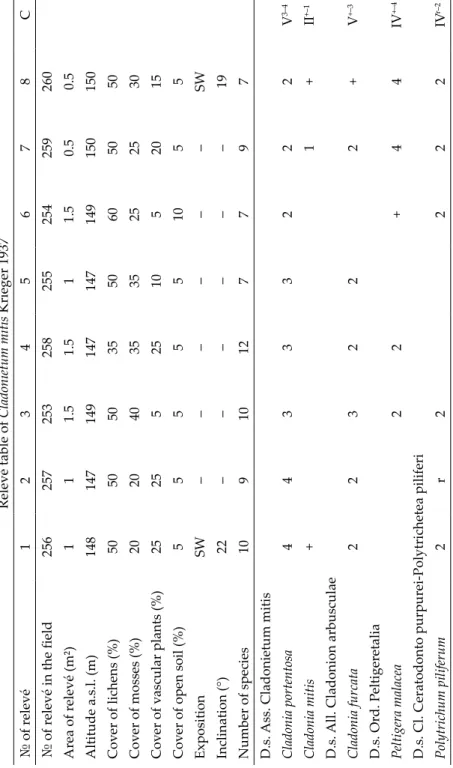
Table 6 Relevé table of Cladonietum mitis Krieger 1937 № of relevé12345678С № of relevé in the field256257253258255254259260 Area of relevé (m²)111.51.511.50.50.5 Altitude a.s.l. (m)148147149147147149150150 Cover of lichens (%)5050503550605050 Cover of mosses (%)2020403535252530 Cover of vascular plants (%)25255251052015 Cover of open soil (%)555551055 ExpositionSW––––––SW Inclination (°)22––––––19 Number of species10910127797 D.s. Ass. Cladonietum mitis Cladonia portentosa44333222V3–4 Cladonia mitis+1+II+–1 D.s. All. Cladonion arbusculae Cladonia furcata223222+V+–3 D.s. Ord. Peltigeretalia Peltigera malacea22+44IV+–4 D.s. Cl. Ceratodonto purpurei-Polytrichetea piliferi Polytrichum piliferum2r2222IVr–2
Table 6 (continued) № of relevé12345678С Other species Cladonia chlorophaea+++2+4rVr–4 Cladonia subulata+r++IIIr–+ Placynthiella dasaea++++III+ Abietinella abietina2++II+–2 Brachythecium albicans++II+ Brachythecium salebrosum2++II+–2 Ceratodon purpureus+2+II+–2 Hedwigia ciliata222II2 Grimmia reflexidens+++II+ Cladonia fimbriata++II+ Sporadic taxa: Bryum argenteum (3: +), Cladonia cornuta (1: +), Dicranum scoparium (4: 2), Hedwigia ciliata (4: 2), Hypnum cupressi- forme (4: 2), H. pallescens (4: +), Pleurozium schreberi (2: +); Syntrichia ruralis (3: +). List of localities: 1–8 = Zhytomyr Oblast, Korostyshiv Rayon, outskirts of the Horodske village, right bank of the Teteriv River, 50° 22’ 02” N, 29° 11’ 03” E, 10.09.2016.
Table 7 Shortened synoptic table with frequency (%) for the distinguished associations* Lichen community132456 Number of relevés2422211198 Mean % cover90.888.5867078.678 Mean number of species per relevés107.47.97.78.38.9 Total number of species323036301723 D.s. All. Parmelion conspersae Xanthoparmelia pulla63647627 Xanthoparmelia stenophylla423210018 D.s. Ord. Rhizocarpetalia Aspicilia cinerea100232955 Lecidea fuscoatra674543 Xanthoparmelia conspersa54100199 Rhizocarpon distinctum29362927 Buellia badia135299 D.s. Cl. Rhizocarpetea geographici Acarospora fuscata71323327 Lecanora alpigena46149 Diploschistes scruposus14199 D.s. All. Aspicilion calcareae Circinaria calcarea22 D.s. Ord. Verrucarietalia nigrescentis D.s. Cl. Verrucarietea nigrescentis Myriolecis dispersa456
Table 7 (continued) Lichen community132456 Verrucaria nigrescens4544 D.s. All. Cladonion arbusculae Cladonia furcata88 D.s. Ord. Peltigeretalia Peltigera malacea63 D.s. Cl. Ceratodonto purpurei-Polytrichetea piliferi Polytrichum piliferum75 Other species Candelariella vitellina83415264100 Protoparmeliopsis muralis6755674589 Polysporina simplex8359484567 Acarospora sp.54104544 Lichenothelia tenuissima50321418 Circinaria contorta5100 Lichenothelia convexa23956 Bellemerea cupreoatra556 Physcia caesia56 Cladonia portentosa100 Cladonia chlorophaea1488 Cladonia subulata50 Placynthiella dasaea50 Lichen community: 1 = Aspicilietum cinereae (Table 2), 2 = Parmelietum conspersae (Table 3), 3 = Parmelietum somloensis (Table 4), 4 = Aspicilio cinerei-Ramalinetum pollinariae (Table 5), 5 = Aspicilietum contortae (Table 6), 6 = Cladonietum mitis (Table 7). * = only species with constancy 50% and more at least in one column, are shown
lichens on nutrient-poor soils (Fig. 5). The average number of species per rel- evé is 8.8. The association characterised by a high total cryptogamic layer cov- er consisted of 70–90% (Table 6). The lichen cover is up to 35–60%, the cover of bryophytes varied from 20 to 40%. The vascular plant layer was rare and sparse (up to 25%). The minimal area of its communities is 0.5 m2. The species composition of the association has a well-defined biological component. Rath- er subacidophytic to subneutrophytic, mesophytic, occurred in sun-exposed sites without extreme solar radiation. The association is quite variable, the cover of lichens and bryophytes varies depending on natural conditions. It is usually found on even or occasionally on slightly sloping surfaces of different exposures. In the study area, it is often found on almost horizontal sections of granite outflows underlying thin layer of accumulated soil.
DISCUSSION
The epilithic lichen communities of the Teteriv River basin are common on siliceous outcrops of the Ukrainian Crystalline Shield located in the for- est zone of Ukraine. Only one epigeic association Cladonietum mitis was de- scribed on siliceous screes near outcrops along the river bank. The distinctive features of all studied associations are poor species composition including 3–14 of lichen and moss species per relevés (the mean species per relevé is 8.4) and high total cryptogamic cover (up to 98%). We believe that it is mainly determined by the natural conditions of the territory, particularly, by humid- ity level and the chemical composition of substrate (in most cases, the species composition of lichens on siliceous substrate is poorer than on carbonates).
The mean environmental values of all associations are fairly homogeneous and indicate that the studied communities rather acidophytic to neutrophyt- ic, photophytic, mesophytic to slightly xerophytic. More detailed analysis of ecological characteristics of lichen communities requires the development of ecological indicator values adapted for Ukraine.
Crustose lichens prevail in floristical compositions of the epilithic lichen associations from the classes Rhizocarpetea geographici and Verrucarietea ni- grescentis, with higher coverage; where the foliose and fruticose species are much less distributed and their coverage is less, as well. Lichens with leprose crustose thallus are very rare and usually occur in some more shaded and wet sites. The fruticose lichen Ramalina pollinaria occurs sporadically in the epilith- ic communities from class Rhizocarpetea geographici and this species is diag- nostic to the new association Aspicilio cinerei–Ramalinetum pollinariae. Species with Cladonia-type thallus are rare in all epilithic associations and dominate in the epigeic association Cladonietum mitis.
Lichens, such as Acarospora fuscata, Candelariella vitellina, Lecidea fuscoatra, Polysporina simplex, Protoparmeliopsis muralis are the most frequent species for
all epilithic associations. Some of them are diagnostic to syntaxa of different rank (Table 7). Candelariella vitellina, Polysporina simplex and Protoparmeliopsis muralis occur in more than 60% of all relevés. According to our observations, the foliose and fruticose species are almost completely absent and some crus- tose species (Candelariella vitellina, Lecidea fuscoatra, Polysporina simplex, Pro- toparmeliopsis muralis) have very high coverage on the rock surfaces actively ex- posed to anthropogenic influences (trampling, breeding of honeycombs, etc.).
CONCLUSIONS
This study is the first attempt to explore the lichen communities of the Teteriv River basin. Five epilithic lichen associations, one subassociation of two alliances and two orders of the classes Rhizocarpetea geographici and Verrucarietea nigrescentis, and one epigeic lichen association, one alliance and one order of the class Ceratodonto purpurei-Polytrichetea piliferi have been described. The associations Aspicilietum contortae, Cladonietum mitis, Par- melietum conspersae, Parmelietum somloensis and the alliance Aspicilion calca- reae were found to be new for Ukraine, as well as the new association Aspicilio cinerei-Ramalinetum pollinariae is described in this paper.
The results of our study covering lichen communities of Teteriv River basin is merely a small contribution to developing syntaxonomy of Ukraine’s cryptogamic vegetation. We hope that this field will be developed rapidly in Ukraine, and much more information will appear soon covering this subject.
*
Acknowledgements – The authors are grateful to Prof. S. Y. Kondratyuk (Kiev, Ukraine) for his advice and support during this research and useful remarks to the manuscript; and Dr L. Lőkös (Budapest, Hungary) for his valuable and detailed comments, which allowed us to improve the manuscript.
REFERENCES
Boiko, M. F. (2008): A checklist of the bryobionta of Ukraine. – Aylant, Kherson, 264 pp. [in Ukrainian]
Boiko, M. F. (2014): The second checklist of bryobionta of Ukraine. – Chornomors’k. Bot. Z.
10(4): 426–487. https://doi.org/10.14255/2308-9628/14.104/2
Braun-Blanquet J. (1964): Pflanzensoziologie: Grundzuge der Vegetationskunde. 3 Aufl. – Springer Verlag, Wien, New York, 865 pp.
Bültman, H. and Daniëls, A. (2009): Lichens and vegetation – a case study of Thamnoli- etum vermicularis. – Bibl. Lichenol. 100: 31–47.
CABI (2016): The Index Fungorum. – http://www.indexfungorum.org. (accessed 5 January 2018)