Traces of prehistoric land use on the Süttő plateau
by Zoltán Czajlik, Eszter Fejér, Katalin Novinszki-Groma, András Jáky, László Rupnik, F. Zsófi a Sörös, András Bödőcs, Péter Csippán, Gabriella Darabos, Rebeka Gergácz,
Dorottya Györkös, Balázs Holl, Géza Király, Dóra Kürthy, Boglárka Maróti, Mónika Merczi, Máté Mervel, Balázs Nagy, Sándor Puszta,
Szilvia B. Szöllősi, Bíborka Vass and Szabolcs Czifra
Abstract
According to recent research, the Early Iron Age settlement and cemetery complex situated on a loess plateau above the Danube river in the western vicinity of Süttő, in northeastern Transdanubia, can be interpreted as a complex landscape used in various ways during several prehistoric eras. Excavations on the fi rst half of the 20th century concentrated more on the research of the tumulus fi eld. In the 1970s and 1980s, thanks to the efforts of Éva Vadász and Gábor Vékony a further tumulus, the fortifi ed settlement of the Nagysánctető as well as most part of the Early Iron Age fl at cemetery came to light. This study summarizes the results of the research conducted in the framework of the Iron-Age-Danube programme, which started in 2017. Beside aerial archeology, geophysical surveys, fi eld walkings and sediment drillings, trial excavation also added precious new data on the diverse uses of the landscape by the communities inhabiting different parts of the plateau in several prehistoric eras (Early, Middle and Late Bronze Age, Early and Late Iron Age). On-site procedures were complemented by laboratory research (examination of ceramics, metal objects, bone and stone material, botanical remains), which contributed to our knowledge on the prehistoric use of natural resources in the area.
1. Introduction
Our fi rst fi eld walkings took place on the Süttő plateau nearly 10 years ago. These activities – more like fi eld trips – served the purpose of familiarizing a new generation of students and researchers with this large-scale site complex, formerly explored by Éva Vadász and Gábor Vékony, who, unfortunately, can no longer be consulted on the matter.1 The archive photographic material, which can be considered as a forerunner of the regular archaeological aerial photography started in 2013, was only used in t he study of the Roman border and the limes road; the geophysical research that began in 2014 had no precedent. Thanks to this preliminary work and our joint fi eld training with researchers from the Institute of Archaeology at the Hungarian Academy of Sciences, Gábor Serlegi and Bence Vágvölgyi, we gained more and more complex information on the basis of which we proposed the area to the Iron- Age-Danube programme. Since 2015, our results are continuously presented at
1 One of these students was Katalin Novinszki-Groma, who currently processes the results of their excavations in the framework of her doctoral thesis.
conferences,2 published in preliminary reports,3 in thematic volumes,4 as well as in our methodological5 and promotional6 publications.
The aim of our study is to present the geographical background, the history of research, the applied methodology, the Early Iron Age landscape use and its antecedents and descendants, as well as the exploitation of landscape resources.
2. Geographical background (fi g. 1)
The Early Iron Age settlement complex (Süttő – Nagysánctető, Nagysánc), with associated cemeteries (Sánci-dűlő, Sáncföldek) were established on the top of the loess plateau next to the Danube. Discussed in detail in our previous publications, there were two settlements on the loess plateau cut up by gullies, sloping into the Danube (the fall is approximately 40 m), and the necropolises were further south.
2 Novinszki-Groma 2017a; Czajlik et al. 2019.
3 Czajlik et al. 2017; Czajlik et al. 2018.
4 Czajlik et al. 2015; Novinszki-Groma 2017b; Novinszki-Groma 2018.
5 Bödőcs/Rupnik 2019; Bödőcs et al. 2019; Czajlik/Doneus 2019.
6 Bödőcs/Rupnik 2018a; Bödőcs/Rupnik 2018b; Czajlik 2018; Czajlik/Puszta 2019; Czajlik/
Király 2019.
Fig. 1: Geographical location of the Süttő micro-region (László Rupnik)
187 Traces of prehistoric land use on the Süttő plateau
The part of the plateau near the Danube was split into blocks separated by deep gullies due to the suffosion of the loess, making them a naturally protected place for settlement. The series of loess plateaus, which can be followed from Dunaalmás to Tát, are bordered by hills from the south, and the Neszmély – Süttő section by the Gerecse mountain range, which reaches here 450 m high.7 While the right bank of the Danube is characterized by a bluff and hills, the left bank, belonging to Slovakia, is an almost fl at, alluvial plane with traces of former river beds in the section between Virt (Vért) and Kravany nad Dunajom (Karva). Several major islands (for example the Mocsi Island) are located in this part of the Danube. These topographical conditions made the formation of a unique micro-region possible.
The current vegetation cover of the cut-off part of the plateau next to the Danube is varied with deep gullies as well as the westernmost loess block covered with dense bushy forest. The sides of Nagysánctető and Nagysánc are also overgrown with vegetation, but their top is used as a meadow. In the southern part of the plateau, partially split by a prolonged gully (Sánci-dűlő, Sáncföldek), grain monoculture is cultivated, which is crucial for the organization of research.
3. Research history
While part of Transdanubia’s signifi cant Early Iron Age tumulus fi elds (such as Érd/
Százhalombatta and Nagyberki – Szalacska) became internationally known from the 19th century topographical summary of Flóris Rómer,8 the tumuli of Süttő were fi rst introduced to the European research only by the comprehensive paper of Ferenc Tompa9 in the mid-1930s. Although Süttő is often mentioned in international literature due to the burial mound excavated by Éva Vadász in 1978–1982,10 the research history and topographical conditions of the site complex are lesser-known to researchers.
The fi rst systematical topographical study of the Süttő site was carried out in 1968–
1971 by István Horváth and István Torma in the framework of the Archaeological Topography of Hungary. In addition to the identifi cation of some of the tumuli, on the basis of the two previously known hillforts, an Early Iron Age site complex similar to Százhalombatta was documented.11 The research programmes of Éva Vadász and Gábor Vékony between 1978 and 1990 included both the Nagysánctető settlement and the burial mounds, as well as the fl at cemetery found in the meantime,12 however, their results could not be processed and evaluated before their passing.
In addition to the Early Iron Age site complex, archaeological remains of several other periods are also known from the Süttő plateau and from the narrow Danube
7 Czajlik et al. 2015, 62–66, fi g. 4.
8 Rómer 1878, 127–128, 115–121.
9 Tompa 1934–35, 104; cf. also Mérey-Kádár 1958.
10 Teržan 1990, 166; Stegmann-Rajtár 1992, 103–104, fi g. 38; Egg 1996a, 7–8, fi g. 4; Egg 1996b, 65; Brosseder 2004, 126, fi g. 88; Golec 2004, 541–542; Hansen 2011, 304, fi g. 17; Kmeťová 2011, 264, fi g. 1.
11 Horváth et al. 1979, 311–313.
12 Vadász 1983; Vadász 1986.
bank below. Based on the aforementioned topographic work and excavations, we can count with the settlements of the Neolithic Age, Early Bronze Age(?), Middle Bronze Age and Late Bronze Age on Nagysánctető prior to the Early Iron Age fortifi ed settlement. Horváth and Torma observed the settlement remains of the Early Bronze Age Hatvan culture on a loess block called Kissánc, located east of the hilltop settlement; in the west, on the Nagysánc, traces of Late Bronze Age, Early Iron Age and Celtic settlements were identifi ed.
In the Hosszú-valley between Kissánc and Nagysánctető, on the bank of the Danube, Erzsébet Nebehay and Amália Mozsolics excavated a part of a Middle Bronze Age (Magyarád culture, Transdanubian Encrusted Pottery Culture) settlement. Roman ceramic fragments were also reported from the same place.13 Moreover, under the bridge of the highroad along the Danube, two Roman milestones were found in the section between Nagysánctető and Nagysánc,14 suggesting that the limes road could follow the same trail as the modern road today.
Unfortunately, during the archaeological topographical works of 1968–1971 – except for the cultivated tumulus groups and Nagysánctető – no detailed land-survey of the tumulus fi eld and the fortifi ed settlements was carried out. Partly this shortage was overcome by the preliminary announcement of Éva Vadász, who enlarged the map of the 1979 publication,15 and gave a detailed description of the tumulus groups.16 A total of 16 mounds were recorded in four groups, and according to her, the area of the entire tumulus fi eld was approximately 1 km2. In her opinion, the mounds were lined up in NW-SE direction within the tumulus groups and indicated the location of former roads leading to Nagysánctető. According to the author, besides the well-known tumuli, a number of additional mound traces were observed in the area marked by stony zones. The burial mound excavated by Éva Vadász from 1978 to 1982 was the easternmost tumulus of the southern tumulus group ‘F’, and at the same time, it was the fi rst modern excavation at the site. The most cited result was the discovery of the NW-SE-oriented dromos structure; but from a topographic point of view, it was at least as signifi cant that – unlike other tumulus excavations at that time – their excavation trench was extended to the edge of the tumulus base and thus the remains of the stone cover (or a stone circle?) were also documented.17 In addition to the preliminary reports, only the remaining parts of the excavation documentation can be used to fi nd out the topographic conditions of the fl at(?) cemetery with 82 graves revealed at Sáncföld in 1983–1990. The necropolis oriented roughly in N-S direction was in the southern approach zone of Nagysánctető, the closest graves were at a distance of maximum 50 m from the edge of the outer ditch and at least 200 m from the nearest standing burial mound. An interesting detail of the cemetery map is that it also captures a semi-circular feature, which – according to its size and shape – could have been a detail of a circular ditch around a tumulus.
Here we note that in her thesis, Anikó Horváth consistently cited the site as the ‘Kis
13 Horváth et al. 1979, site 20/15, 315–317.
14 Rómer 1866, 161, 182.
15 Horváth et al. 1979, 312.
16 Vadász 1983, 19–20.
17 Vadász 1983, 22.
189 Traces of prehistoric land use on the Süttő plateau
halmos’ (small tumuli) cemetery,18 referring to one of the excavation reports of Gábor Vékony, from which one can infer small heaps covering these tombs (or some of them). Another important feature of the site is that among the cremation burials, without a special order, inhumations were also discovered.
18 Horváth 2001, 30.
Fig. 2: The topographic view of the site complex based on previous research (see Czajlik et al. 2015, 66–70, fi g. 7, Balázs Holl/Zoltán Czajlik, 2015).
Source: unifi ed national cartography system of Hungary, M=1:10000
The topographic knowledge of the mid-1980s was recorded by Gyula Nováki on a map in 1985, on which the Sáncföldek excavation site can also be identifi ed, in addition to the survey of the tumulus fi eld and hilltop settlements.19
Parallel to the research of Éva Vadász, from 1979 Gábor Vékony conducted the excavations of the larger, fortifi ed settlement of Nagysánctető. The most important goal was to acquire information on the stone and clay rampart, reinforced by a wooden structure on the upper part,20 which was mainly built on the southwestern side of the settlement not protected by gullies, and reinforced by a double – perhaps partially natural – trench. Another result of the settlement excavations was the documentation of the long wall and semisubterranean buildings. In the latter, besides the ceramic sherds, there were objects related to craft activities (iron slag, clay blocks, spindle whorls, loom weights), which were processed by Móni Szincsák (fi g. 2).21
4. Methods used in landscape research
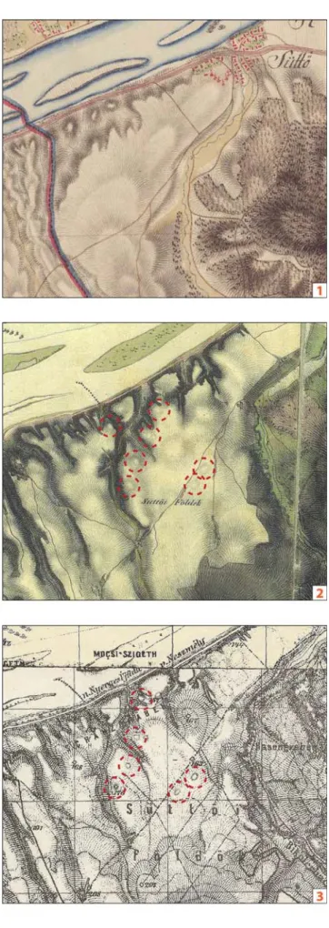
Traces of neither the hilltop settlements nor the tumuli (that must have been taller then) were depicted on the map of the First Military Survey or Josephinian Land Survey of the Habsburg Empire (1763–1787). This situation has changed in the case of the Second Military Survey or Franciscan Land Survey of the Habsburg Empire (1806–1869) and Third Military Survey of the Habsburg Empire (1869–1887). On these two map sources, essentially the same phenomena were delineated from Süttő (fi g. 3): those tumuli that can still be well identifi ed on the surface today, except for the tumulus group ‘C’,22 which is located in a bushy, wooded area and which is not included in any survey. On this basis, two conclusions can be drawn. On the one hand, in the area that is cultivated continuously, we probably cannot count on the destruction of many large mounds in the last 250 years. On the other hand, observations were not made during the mapping work for understandable reasons in forested areas.
As far as we know, the earliest archive aerial photographs are from 1940, when the entire course of the river Danube was recorded throughout the country. Due to the conditions of the vegetation during the photography, only traces of already known tumuli can be observed at Süttő.23 In connection with his research of the Ripa Pannonica, Zsolt Visy also examined the archive footage of this limes section.24 He identifi ed the double trenches of the Azaum/Odiavum 5 Roman Age watchtower and traces of Iron Age tumuli thanks to an aerial photograph from 1954.25 Recently, the number of available recordings has increased signifi cantly through the webpage fentrol.hu. These images can be used for archaeological research in many cases, also
19 Horváth 2001, Pl. VII.
20 Vékony/Vadász 1982.
21 Szincsák 1997.
22 Czajlik et al. 2015, fi g. 7.
23 The images can be found in the collection of the Military History Institute and Museum, Budapest (Inv. Nr: HI 69398-69399).
24 Visy 2003, 41–42, Fig. 62–64.
25 Visy 1990, 24; Visy 2003, 41, Fig. 62. (HI 23119). For the watchtower belonging to Neszmély by administration, see also: Visy 2011, 65, Fig. 51.
191 Traces of prehistoric land use on the Süttő plateau
Fig. 3: The Süttő site complex on the First, Second and Third Military Surveys
of the Habsburg Empire.
(Arcanum/László Rupnik)
Fig. 4: Excavations of Éva Vadász and Gábor Vékony in the 1987 archive aerial photograph. 1 (cf. Fig. 2, area ‘G’) fl at cemetery excavation;
2 (cf. Fig. 2, area ‘A’) rampart/gate(?) excavation (fentrol.hu/László Rupnik)
193 Traces of prehistoric land use on the Süttő plateau
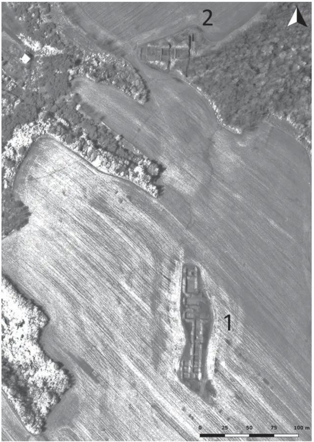
in the case of Süttő. Thanks to the fortunate timing, positive crop signs of the ditch of a previously unknown watchtower can be observed east of the Iron Age site on a photograph from 1975. Besides that, we could identify additional linear phenomena (ditches, former roads?) as well, however, their exact age is questionable. A series of images from 1987 shows the open excavation trenches of Gábor Vékony and Éva Vadász (fi g. 4). The importance of this information is enhanced by the fact that a complete map of that excavation has not been retained – now its location can be reconstructed based on the aerial photographs. Using a photogrammetric process, with a suffi cient number of photographs from these fl ights, a digital surface model (DSM) can also be made (fi g. 5).
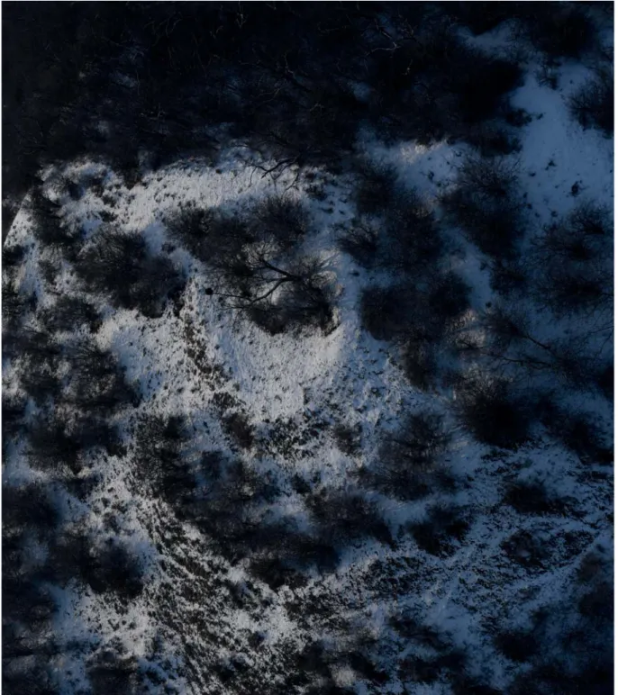
The regular aerial archaeological investigation of the Iron Age site complex began in 2008,26 and by the end of 2018 we carried out archaeological prospections on 12 occasions with Cessna aircrafts and Robinson helicopters.27 Of the winter aerial surveys, the one on February 28, 2018 is worth mentioning, when the tumulus group
‘C’, located in a separate loess block, was fi rst documented. At the edge of the plateau north of the tumuli, overlooking the Danube, the remains of the Azaum/Odiavum 5 Roman Age watchtower – in the bushes – were also photographed (fi g. 6). Thanks to
26 Czajlik et al. 2015, 64.
27 For a summary of the previous fl ights, see: Czajlik et al. 2018.
Fig. 5: The tumulus groups of the Süttő site complex on the DSM, generated on the basis of archive aerial photographs (László Rupnik)
helicopter fl ights, we were able to see the site complex from a low altitude (30–50 m), which is not possible with aerial photography at an altitude above 300 m. This helped to better understand the terrain conditions of the area.
The data from the ALS survey along the Danube in 2013 was processed by Géza Király. Since data was only collected from a narrow area next to the Danube during
Fig. 6: Azaum/Odiavum 5 Roman watchtower on an oblique aerial photograph (Zoltán Czajlik, February 28, 2018)
195 Traces of prehistoric land use on the Süttő plateau
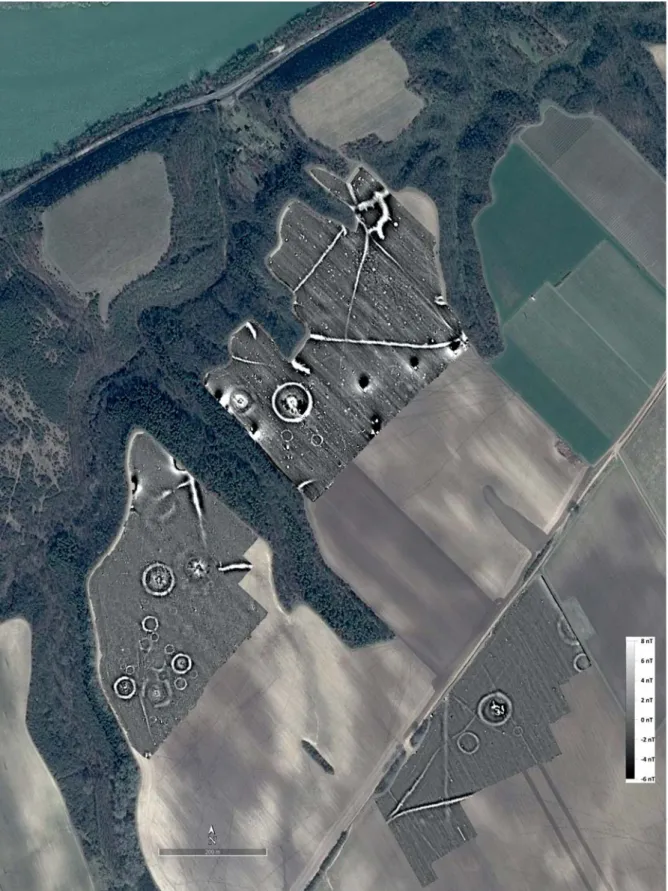
Fig. 7: Magnetometer survey of Süttő – Sáncföldek and Sánci-dűlő (autumn 2017 – winter 2019, processed by Sándor Puszta;
source of the background: GE-imagery, 29 March 2017)
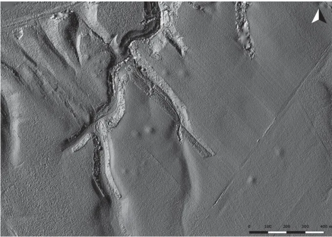
the fl ight in question, it was not possible to produce a model from the zone of the tumulus group ‘F’ in the south, or the southern part of the tumulus group ‘E’. The data covers a total of about 5.4 km2 with a dot density of ~7.8 points/m2, namely a total of about 41.9 million points. The most important result is that we got a clear picture of the split parts of the loess plateau, especially the gully system. The tumulus group of the northwest plateau block is also clearly visible on the model.
The fi rst magnetometer measurements at the Süttő plateau were conducted on October 28, 2014. The method we used was developed by Balázs Holl and Sándor Puszta in several steps from 2007 onwards, the most important devices used to date were two GSM19W Overhauser magnetometers and a Trimble Geo 7 GPS. They were arranged and used identically during all the surveys. The problem of the temporal change of the magnetic fi eld was solved by local base measurements, and the rover unit proceeded in variometer layout. The GPS data were corrected on the basis of base stations.28
In the framework of the Iron-Age-Danube project, the fi rst geophysical surveys were carried out in 2017 (two days both in the spring and the autumn) on the southernmost part of the site complex, south of the dirt road connecting Süttő and Dunaszentmiklós. The resulting magnetic anomaly map shows a remarkably clear geological background. The encircling ditches of the larger, well-known tumuli, as well as two additional, smaller (each one is approximately 20 m in diameter) circular ditches were observed, similarly to the situation of tumulus group ‘E’ in 2014 and tumulus group ‘D’ in 2016 (fi g. 2).29
Adapting to the monoculture cultivation, the next time window opened in late summer of 2018, when the area ‘G’ was surveyed, including the remeasurement of the zone ‘D’ (fi g. 2). In the case of the latter tumulus group, around one of the hypothetical stone burial chambers, a Mala GPR equipment was also used besides the magnetometer measurement, without any particular results. The geological background of the magnetometer measurements in this zone was also remarkably uniform and clear. We could only start the magnetic survey of the entire NW part (tumulus group ‘E’, omitting the parts already measured in 2014) at the end of 2018 (fi g. 2), after the corn harvest, which we could only fi nish in February 2019 due to the winter weather. As a result of the measurements, we were able to get to know the remnants of a very complex tumulus group with large mounds not necessarily encircled with a ditch, and several small (about 20 m in diameter) circular ditches (fi g. 7).
Since 2017, magnetometer geophysical measurements were accompanied by drone photography several times after the fi rst adaptation of this method during the 2016 joint survey with the Institute of Archaeology at the Hungarian Academy of Sciences.
The RPAS (Remotely Piloted Aircraft System) technology has helped our work in many ways. The simplest use was the documentation of fi eld work with photographs and video footages. In addition, we have regularly monitored the individual burial mounds
28 For a summary of the geophysical surveys at Süttő between 2014 and 2016, see: Czajlik et al. 2019.
29 For the results of the geophysical surveys in 2017, see: Czajlik et al. 2017.
197 Traces of prehistoric land use on the Süttő plateau
and their environment to supplement the data from conventional aerial photography.
The most signifi cant part was the 3D-modeling based on photogrammetry. For this, we took photographs of the area of the systematic fi eld walkings and archaeological excavation and the parts of the site-complex that were missing from the ALS-based digital terrain model. During these fl ights, we used DJI Phantom 4 and Phantom 4 Pro Plus platforms, which were carried out partly freely, partly automatically on the basis of previously programmed parameters. The programmed fl ights were designed with the DJI Ground Station Pro software, and we also installed ground control points (GCP) measured by GPS for later use in a GIS software. We used the Agisoft Metashape to process the photographs and create surface models (DSM) (fi g. 8).
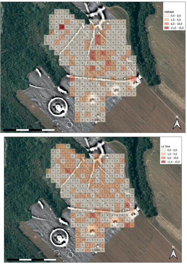
In 2016, during the simultaneously conducted large-scale fi eld surveys and drone aerial photography, traces of a previously unknown Early Iron Age settlement west of the southern tumulus group (‘F’) were observed (fi g. 2).30 Also in combination with the above-listed methods, intensive systematic fi eld walkings were conducted under the leadership of László Rupnik in 2018 at the area of Sáncföld, where 256 times 20x20 m squares were surveyed in a total of 10.24 hectares using a virtual grid. A square was
30 Czajlik et al. 2019.
Fig. 8: Tumulus group ‘F’ (cf. fi g. 2) on the DSM, generated on the basis of drone photographs (László Rupnik, March 2019; source of the background:
ortophoto, 2005 – Department of Geodesy, Remote Sensing and Land Offi ces, Government Offi ce of the Capital City Budapest)
Fig. 9: Systematic fi eld walking surveys in Süttő – Sáncföld (area ‘G’, cf. fi g. 2) August-September 2018 (above: Hallstatt, below: La Tène fi ndings with
geophysical survey; Rebeka Gergácz – Sándor Puszta – László Rupnik;
source of the background: GE-imagery, 29 March 2017)
199 Traces of prehistoric land use on the Süttő plateau
walked through by one person about 15 minutes in two orthogonal directions, the position of the fi nds was recorded with handheld GPS devices, and the fi nds were packed by squares.31 The survey was carried out by 4–6 people in total for 5 days, mostly in sunny, good weather. The surface was a scarifi ed wheat stubble, sometimes with growing weeds. Only 28 of the surveyed squares were found to be devoid of fi nds; in the others, Middle and Late Bronze Age, Early and Late Iron Age, Roman Age and modern sherds were collected. Late Bronze Age/Early Iron Age, defi nitely Early Iron Age and Late Iron Age material was represented in the highest proportion (fi g. 9). Modern sherds and other objects pointing to the disturbance of the site were scattered throughout the area, but their number rarely exceeded 3–4 pieces per square. In addition to the ceramic sherds, several metal objects and processed stones were also collected during the survey. In parallel with the geophysical measurements, systematic fi eld walkings were complemented with a metal detector survey by Lajos Sándor. Finds from metal detecting were cleaned and then sorted by age together with the fi nds from the surface collection. The location of the excavation Trench 1 was designated based on the geospatial processing of these results compared to the map of the geophysical measurements, northwest of the previous excavations at a distance of 100–120 m.
In the sub-chapter 2 presenting the geographical background of the area, we have already described in detail the parts and the surface cover of the suffosed loess plateau next to the Danube. In the previous topographical sub-chapters, we also presented the scenes of former human activity. All examinations were based on measurements and analyses related to the current surface; we could only gain information about the deeper layers indirectly (aerial photographs, magnetic mapping). Since detailed geomorphological mapping plays a major role in determining the current and present state of the natural landscape and in the exploration of human infl uences, we have tried to explore at least part of the area with sediment drilling.
Drillings were carried out by geographer students of the Eötvös Loránd University and András Bödőcs under the leadership of Balázs Nagy in September 2018 (50 drillings in 2 days), and by Balázs Nagy, András Jáky and László Rupnik (45 drillings in 1 day) during the next time window in March 2019 with Ejkelkamp sampling equipment.
In the course of the research, a preliminary study of Nagysánctető (Area ‘A’), the Early Iron Age fl at cemetery (Area ‘G’), the northeast tumulus group (‘D’) and the northwest tumulus group (‘E’) was conducted (fi g. 2).
We already had information about the layer sequence of Nagysánctető based on the excavations of Gábor Vékony32 as well as the work of Anikó Horváth.33 They reported on a signifi cant layer sequence going back to the Neolithic Age, reaching 2 m depth in the south-western part of the plateau. However, based on the 2018 research, it
31 The long-established method of grid walking was used in many of our previous researches (Czajlik et al. 2010; Czajlik et al. 2015). An improved version for a whole micro-region (100x100 m virtual grid, using manual GPS devices) was developed by Gábor Mesterházy and Máté Stibrányi (Mesterházy/Stibrányi 2012), which was adapted by László Rupnik for the IAD programme.
32 Vékony 1986.
33 Horváth 2001.
is clear that this thick culture layer cannot be characteristic for the whole area, as our drillings generally reached the non-humus loess zone in a 40–70 cm, less often 90–110 cm in depth. At the same time, the presence of more signifi cant culture layers in the zone some 80–190 cm deep from the surface can be reinforced in the western part near the former excavation.
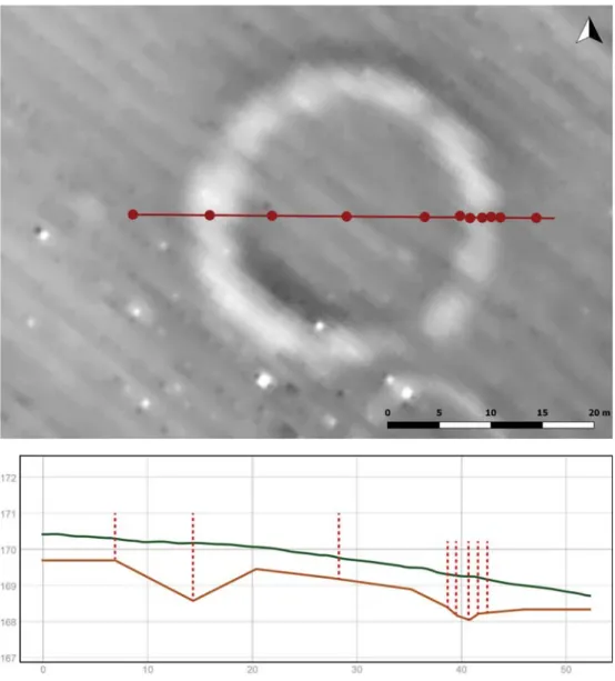
The overwhelming majority of the drilling series was carried out in the northern part of the tumulus fi eld. The main purpose was to determine the depth and shape of the circular ditches identifi ed by magnetometer geophysical survey, but we also tried to obtain information about other linear structures. The ditch depth of the western, smaller member of tumulus group ‘D’ is 340 cm. At the larger, eastern mound opposing sections of the circular ditch were also examined and differences in shape and depth were documented, the latter being between 110 and 230 cm. There was an even greater difference between the individual members of the tumulus group
Fig. 10: Archaeological geomorphological drilling results of tumulus 2
(in tumulus group ‘E’, cf. fi g. 2) (Balázs Nagy – Sándor Puszta – László Rupnik, 2018–2019)
201 Traces of prehistoric land use on the Süttő plateau
‘E’: the largest mound here – as it is also apparent on the geophysical anomaly map – does not have a circular ditch at all. As far as linear structures are concerned, it was possible to distinguish between the structures which can be considered as natural continuations of the gullies and the traces of former paths in both area ‘G’ and around tumulus group ‘E’ (fi gs 2, 10).
Prior to the excavations topographic information collected on the basis of previous excavations as well as all surface research (magnetometer, systematic fi eld walking, and metal detector surveys) were evaluated. Our goal in selecting the specifi c location was to better understand the topographical conditions of the Early Iron Age fl at cemetery and its surroundings.34
5. Landscape use in the Bronze Age
Previous topographic research (see above) proved that the Süttő plateau had been intensively used in the Bronze Age: several assemblages of various periods were revealed from Kissánc, Hosszú-valley, Nagysánctető, Sáncföldek and Nagysánc.35 Our recent fi eldwork could provide some further archaeological data on the Early and the Late Bronze Age landscape of the area.
In Trench 1 a heavily disturbed Early Bronze Age cremation grave was excavated (STR 5). This feature was selected for systematical archaeobotanical sampling, which was led methodologically by Mária Hajnalová, an expert of the Constantine the Philosopher University in Nitra (UKF). A 50x50 cm grid system was laid over the grave, but in case of ceramic concentrations or other interesting archaeological observations, these units were divided into separate sub-units. Soil samples were collected from every 5 cm of each unit. Because of the intensive modern agricultural use of the territory, the fi nds of the shallow grave had been scattered, thus neither the outlines of the burial pit nor the complete inventory and the original position of the grave goods could be identifi ed. Beside cremated human remains the grave contained a set of very fragmented vessels and animal bones. The inventory of the burial dates the feature to the Makó-Kosihy-Čaka period and the 14C dating correlates with this result (2620–2460 calBC). The presence of Early Bronze Age material on the Süttő plateau is not completely surprising, previous archaeological research (topographic surveys and an excavation) have already indicated its distribution in the area.36 In the
34 Czajlik et al. 2018.
35 Assemblages from Makó-Kosihy-Čaka, Hatvan, Transdanubian Encrusted, Magyarád/
Mad’arovce, Tumulus and Urnfi eld type archaeological material are known from these sites:
MRT 20/3, 20/4, 20/6, 20/15 (Horváth et al. 1979); Kovács 1988; Vékony/Vadász 1982).
36 Early Bronze Age material was reported from the excavation of Nagysánctető (Vékony/
Vadász 1982) and from the neighbouring sites of Horváth et al. 1979, 20/4 (Kissánc) and 20/13 (Tatai úti dűlő II). Furthermore, some stray fi nds are also known from Süttő (Horváth et al. 1979, 320.)
wider region of Süttő several excavated sites (settlements and graves) have yielded Makó-Kosihy-Čaka assemblages.37
In Trench 2 two Late Bronze Age features were documented (STR 18 and STR 16).
Both had an irregular shape and large dimensions (4x2,5–4 m, 0,5–1 m deep) – their function is unknown. The smaller feature (STR 16) contained a considerable amount of archaeological material: pottery, animal bones, stones, daub fragments, and a small bronze object. Although on the bottom of the feature a debris-layer of burnt daub was excavated, no postholes were detected which would indicate the existence of a permanent built structure. The other feature (STR 18), located 2–3 m to the north from feature STR 16, was larger, deeper and contained much more archaeological material: a huge amount of ceramic fragments, bones, stones, and a couple of bronze objects were unearthed. No layers could be distinguished in its fi lling and there was no sign of any built structure connected to it. The typological characteristics of the
37 A burial of the culture was discovered in Lábatlan ‒ Rózsa Ferenc street, settlements were detected in Lábatlan ‒ Hosszú földek (formerly Süttő ‒ Vasúti őrház), Nyergesújfalu
‒ Józsefpuszta, Mužla (Muzsla) ‒ Čenkov-Vilmakert and Orechovy sad, Mužla (Muzsla) ‒ Svätojurský vnútorny hon (Kulcsár 2009, Cat.Nr. 165, 166, 194, 230, 231, 346, 347).
Fig. 11. Late Bronze Age bronze dagger from Feature 18 (photo: József Bicskei) and the results of the prompt gamma activation analysis (PGAA)
(Boglárka Maróti, for the method see: Révay/Belgya 2004)
203 Traces of prehistoric land use on the Süttő plateau
pottery found in both pits, as far as its fragmented condition allows a reconstruction, are closely related to the ceramic tradition of the Late Tumulus and Early Urnfi eld periods. A completely preserved bronze dagger38 from the larger pit suggests a similar dating (RB D, fi g. 11). Based on these results, a Late Tumulus/Early Urnfi eld settlement can be assumed at Süttő – Sáncföldek, which was probably used contemporarily with the neighbouring settlement of Nagysánctető.39 The 14C data from these two features (1430–1220 calBC) correlate with the typological observations.
6. Data for reconstructing the Early Iron Age landscape (fi gs 2, 7, 14)
The discovery of the site in the 1930s is probably not due to the hilltop settlements on loess blocks near the Danube, but rather to the spectacular groups of tumuli.
Three of the four tumulus groups are relatively close to each other (200–300 m as the crow fl ies), but are located on different sections separated by steep gullies. The south- eastern tumulus group ‘F’ is located at least 600 m from all of these, and markedly far (at least 1 km) away from the hilltop settlements. Three of the four tumulus groups have been under intensive agricultural cultivation for decades, still they are well recognizable in the landscape. Two members of tumulus group ‘D’, four to fi ve members of tumulus group ‘E’ (fi g. 12), and also two members of tumulus group
‘F’ can still be identifi ed from the surface, on aerial photographs taken from low altitude partly from helicopter, partly by drone, and on photogrammetry and ALS- based terrain models. According to the geophysical mapping, the large mounds have impressive circular ditches both in the case of tumulus group ‘F’ and ‘D’. Interestingly, one of the most impressive mounds of the entire site complex, burial mound 4 in tumulus group ‘E’, does not possess an encircling ditch based on the geophysical survey, and no such construction can be inferred from the sediment drilling either (fi g. 13). Slightly south in the same zone, a large circle can also be observed on the magnetic anomaly map, which was perhaps only partially completed. Besides tumuli of exceptional size, wide and deep circular ditches of large diameter usually referring to such tumuli, as well as medium or even small-sized circular ditches can also be observed based on magnetometer surveys. The latter occur in all tumulus groups, (cf. fi g. 2). Tumulus group ‘C’, not affected by modern agricultural cultivation, could not be investigated by magnetometer due to the bushy vegetation cover, however, on the basis of the ALS terrain map, one larger and several small/medium- sized examples can also be detected among the tumuli. It should be noted that we
38 The characteristic dagger belongs to the type “Ringknaufdolch” and it has not been known before from closed archaeological context in the territory of Hungary. The type is dated to the Late Tumulus ‒ Early Urnfi eld Period (Kemenczei 1988, 23–27).
39 On the basis of the published report of the Nagysánctető excavation, we can assume a Tumulus and Urnfi eld period occupation on the fortifi ed settlement, although it is not clear in which phases the fortifi cation was used. (Vékony/Vadász 1982) During topographic research in the area Urnfi eld type ceramic fragments were observed on several sites close to the investigated territory (Horváth et al. 1979, 20/6 Fekete hídi árok mellett, 20/21 Süttő
‒ Rákóczi street, 20/25 Papi földek, see: Horváth et al. 1979), but their more accurate dating is rarely possible. For the distribution of the Urnfi eld Culture in NE Transdanubia see: Patek 1968 and Kőszegi 1988.
also know the remains of a circular ditch from area ‘G’ (the zone of the fl at cemetery), thanks to the excavations of Éva Vadász.40
The topographic analysis of the four tumulus groups that can still be identifi ed on the spot (fi gs 2, 14) seems to confi rm the concept of previous researchers in the case of several other sites, namely, that these separate tumulus groups of 1–2 larger and several smaller mounds represent different social units and/or period and a hierarchy within the groups by the size of the burial constructs. Insisting on topographical data, tumulus group ‘E’ stands at the top of the Süttő hierarchy with the highest number of tumuli and including Tumulus 4 without a circular ditch. It should be noted that this is not only the largest and the most numerous group, but also located in the highest position compared to other areas. It should be highlighted that all other tumulus groups and settlement units of the site complex were also visible from this area. The adoption of the above chain of reasoning would be particularly exciting in the case of Süttő, because according to the fi ndings, there were individuals of very different social status in the fl at cemetery.41 At the same time, it would not be surprising if fi ne chronology or its combination with the above-mentioned concept would settle this matter between the tumulus groups.
40 Czajlik et al. 2015, fi g. 3.
41 Novinszki-Groma 2018.
Fig. 12. Tumulus group ‘E’ (cf. fi g. 2) from the air (Zoltán Czajlik, February 28, 2018)
205 Traces of prehistoric land use on the Süttő plateau
We were unable to identify new graves of the fl at cemetery during modern research, but the large-scale metal detector survey in area ‘G’ resulted in a number of fi bulae in good condition, which could be linked to the previously discovered artefacts of the Early Iron Age fl at cemetery. Their dating and network of connections is similar to the previously known pieces and their presence confi rms the image of the prominent richness of some burials of the necropolis in question (fi g. 15).42
Thanks to archive and modern aerial photography, and especially the ALS relief model, we can now imagine the former appearance of Early Iron Age hilltop settlements better than before. Especially the ALS model, which is free of the vegetation cover, shows how distinct both hilltop settlements were from their surroundings. It is also clear on the basis of the model why it was not necessary to fortify area ‘B’ (Süttő – Nagysánc), and why and where it was justifi ed to artifi cially strengthen the protection of area
‘A’ (Süttő – Nagysánctető) (fi g. 14). In the latter case, the results of archaeological geomorphological drillings refi ne the image created by the excavations of Gábor
42 Novinszki-Groma 2017b.
Fig. 13: Archaeological geomorphological drilling results of tumulus 4
(in tumulus group ‘E’, cf. fi g. 2) (Balázs Nagy – Sándor Puszta – László Rupnik, 2018–2019)
Vékony and the research of Anikó Horváth. Comparing the data of the drillings and the microrelief of the plateau, the center of Neolithic, Early Bronze Age, Late Bronze Age and Early Iron Age settlements were clearly in the south of the Nagysánc-tető.
7. Survival of elements of Early Iron Age landscape in the Late Iron Age The intensive use of the landscape, largely and permanently transformed in the Early Iron Age has started again at the end of the Early Celtic period. Previous research already documented traces of Celtic settlements and cemeteries from certain parts of the plateau. The area called Nagysánc (Horváth et al. 1979, site 20/6), west of Nagysánctető, is also known as a Celtic settlement based on surface fi nds.43 This is confi rmed by the publication of Márta H. Kelemen, who dated a characteristic ceramic sherd found here to the LTB – C1 period.44 Additionally, she assumed a contemporaneous cemetery near the Nagysánc settlement on the basis of the typical
43 Horváth et al. 1979, 311–312.
44 Kelemen 1987, 193–194, Pl. XI. 6.
Fig. 14: The actual topographic map of the tumulus groups – analysis based on magnetometer, drone and ALS surveys (Géza Király – László Rupnik;
source of the background: ortophoto, 2005 – Department of Geodesy, Remote Sensing and Land Offi ces, Government Offi ce of the Capital City Budapest)
207 Traces of prehistoric land use on the Süttő plateau
fi nds in Ilona Hunyady’s monograph.45 At the site Süttő – Sáncföldek, during the excavation of the Early Iron Age cemetery, Celtic features (pits?) were also identifi ed by Éva Vadász and Gábor Vékony.
During the 2018 excavation we documented four Celtic features: building STR 24 as well as pits STR 11, 20, and ditch STR 33. The building belongs to the simplest type as it included no postholes.46From its southwest corner, from the demolition layer of the building (STR 41) remains of a child’s cranium (parietal area) came to light, the age of which is 400–210 calBC according to radiocarbon dating. At the bottom of the wide, fl at-bottomed pit STR 11 remains of charred wood were recovered, while on the top of the fi lling layer accumulated fragments of grinding stones, as well as pieces of deliberately (?) crushed ceramics, were found. Ditch (?) STR 8 also yielded Celtic archaeological material.
The fi nd material of the above-mentioned archaeological features consist of a low number of ceramics and signifi cant amount of grinding stones, both heavily fragmented. Based on these, only an approximate dating within the Celtic period is possible. In general, the absolute lack of LT C1 (2nd half of the 3rd century BC – beginning of the 2nd century BC) ceramic forms (for example ring-rimmed bowls, elongated biconical forms, an upward shift in the placement of the shoulder) can
45 Kelemen 1987, 193, Pl. XI. 3.
46 Horváth 1987, 65, fi g. 5.p/1.
Fig. 15: Variations of Early Iron Age bronze Navicella (1–3) and Bow (4) fi bulae from the metal detector survey of the Süttő plateau (September, October, 2018)
(Katalin Novinszki-Groma – Eszter Fejér)
be documented.47 The only hint to this time period is a fragment of a glass bracelet, found on the surface during fi eld survey. Although the Dux type fi bula was also a stray fi nd, chronologically it corresponds to the dating of the ceramic material from the settlement.
The above-mentioned Dux type fi bula is not the only one of its kind known from Süttő:
I. Hunyady mentions another piece found in the area which is practically identical in form to the one found in 2018.48 The few fragments of graphite situlae, the lightly curved S-profi le bowl as well as the wheel-thrown small pot with low-lying shoulder all point to the LT B1–B2a period. A survival of local traditions can be observed in the form of the pot decorated with an incised rib as well as a sherd with graphite slip. Perhaps the horizontally fl atted knob, known from subsequent periods, is also a manifestation of these traditions.
The archaeological material of the neighbouring territories along the rivers Nitra and Žitava inhabited during the LT B period (Veľka Maňa, Kamenín, Hurbanovo-Bacherov majer) yield several parallels to the Süttő material.49 For example, the form of the Dux type fi bula found on the surface is identical to that of a fi bula found in the inhumation Grave 13 of Maňa,50 and another piece recovered in Grave 21 of the Dubník cemetery.51 Beside the Slovakian sites, the fi bula found in Süttő is also related to the fi bulae excavated at the LT period settlement52 and related cemetery53 of Győr-Ménfőcsanak. This site complex, located at the confl uence of the rivers Danube and Rába, came to being at the beginning of the 4th century BC.
In summary, based on the ceramic material, the life of the settlement can be roughly dated to sometime between the 2nd half of the 4th century BC and the 3rd century BC.
Thus the presently available data suggests that the researched part of the settlement was established at the end of the LT B1 period (2nd half of the 4th century BC) and was still in use during the LT B2a period. From the perspective of its wider surroundings, the Late Iron Age settlement of Süttő fi ts well with the Transdanubian settlements established at the end of the 4th century BC. 54
8. Transformation of land use in Roman times:
watchtowers at the edge of the plateau
The remains of a Roman watchtower are located on a peaky height with a steeper side west of the Sánci-dűlő, including the tumuli and the settlement.55 The oval building bordered by a double trench can be observed on many archive aerial photographs and also on the spot. Its northern part has been partially washed away
47 Almássy 2014, 178.
48 Hunyady 1942–1944, XIX. t. 6.
49 Benadík 1963.
50 Benadík 1983, 17. Taf. VI/7.
51 Bujna 1989, Taf. XXIV/2.
52 Tankó/Egry 2009, 404. Fig. 2/1; Tankó 2004, 109. Fig. 4.
53 Uzsoki 1987, 36. Pl. V/2–4, X/1.
54 Bujna 2003, 96. Obr. 64.
55 Azaum 5 or Odiavum 5 burgus: Visy 2000, 39–40, Figs 62 –64.
209 Traces of prehistoric land use on the Süttő plateau
by the Danube. In the early 1930s Albin Balogh found some Roman ceramic sherds here on the surface, but neither was our nor Zsolt Visy’s fi eld walking survey at the same location successful in this regard.56 Both the modern aerial photography carried out in connection with the nomination of the Ripa Pannonica to the UNESCO list of World Heritage Sites,57 and the photographs taken by Zoltán Czajlik – especially the ones shot during snow cover – show the current state of the burgus (fi g. 6).
The next watchtower to the east, known from the literature, is located further away in the area of Lábatlan.58 There must have been more watch-posts between these two, however locating these will be a task for future research. In any case, an archive aerial photograph made in 1975 shows a trace of a feature with rounded corners and a double trench at Süttő – Kissánc (fi g. 16).59 The area confi ned by the internal trench is approximately 15x15 m, the trench is 21x21 m, but the northern part was destroyed by erosion. It has an external dimension of 36x36 m.
56 Balogh 1934, 44.
57 Photo of Máté Szabó (PTL 38677): Visy 2011, 65, Fig. 51.
58 Horváth et al. 1979, 245, 10/7; Visy 2000, 40.
59 fentrol.hu
Fig. 16: Ditch of a Roman watchtower(?) from Süttő – Kissánc on an archive aerial photograph (fentrol.hu/László Rupnik)
This hilltop has been surveyed several times and is known as a Bronze Age fortifi ed settlement.60 At the same time, we do not know any Roman fi nds from this location, only a few solitary stray fi nds from the valley west of it,61 which is probably due to erosion. Additional geophysical or fi eld research is required to identify the phenomenon.
9. Resource exploitation of the Süttő plateau
As described above, the Süttő site complex is located in a special geographical position. In that, the approximately 40 m high loess plateau above the Danube is such a dominant element as the micro-region closed by the Gerecse’s northern stretches in the south, which had a huge buffer zone north of the Danube. Only Anikó Horváth was concerned with this question previously. On the one hand, she suggested that besides the Danube, smaller sources – assumed on the basis of travertine patches – could also play a role in the water supply, while on the other hand she considered the southern part of the plateau (Sáncföldek, Sánci-dűlő) to be the agricultural hinterland of the Early Iron Age settlement.62
Based on our intensive fi eld research, this model of landscape use cannot be maintained. As far as the predecessors are concerned, there are serious Late Bronze Age settlement traces on the northern edge of Sáncföldek, where a signifi cant amount of animal bones have been revealed. With regards to meat-eating, the main domestic species – mainly cattle and caprine – are dominant in the assemblage, but a few bones belonging to wild animals also came to light. It is still a question whether the inhabitants used the Danube as a source of water through the steep gullies or they utilized possible other, more distant sources. Water for people and their animals living on Nagysánc and Nagysánc-tető could also be provided by the Danube in the Early Iron Age. Land use has limited the resources, as a signifi cant part of the well-cultivable, easily accessible lands from the hilltop settlements were covered by burials.
An interesting addition to the Early Iron Age use of vegetal raw materials is the reedmace from earlier excavations (defi nition of Mária Hajnalová). The reedmace did not grow on the Süttő plateau, its closest habitat can only be suspected north of the Danube, in its extensive anabranch system. It is obvious that Early Iron Age monumental land use has limited the size of areas suitable for cultivation in the Late Iron Age as well. Identifying of millet, also observed elsewhere in the Celtic era, among plant debris obtained from the ditch at the edge of the plateau could be a good answer to the problem (fi g. 17).
To identify the connection between the used raw materials and the geology of the region, characteristic stones and ceramics were examinde from the site. The supposed provenances most of the types of limestones from the 2018 excavation occur within a 10 km range of Süttő: Mesozoic (Triassic) micritic limestone; porous Pleistocene
60 Horváth et al. 1979, 311, 20/4; Hungarian National Museum Archaeology Database, https://
archeodatabase.hnm.hu/en/node/27294, December 19, 2019.
61 Site Süttő – Hosszúvölgy: Horváth et al. 1979, 315–316, 20/14.
62 Horváth 2001.
211 Traces of prehistoric land use on the Süttő plateau
travertine and Eocene bioclastic limestone. Among them, the Triassic limestone has to be highlighted, since this type has also been identifi ed from the burial chamber remains of the tumuli coming to light due to agricultural cultivation. This building material was easily accessible in the Gerecse Mountains to the south. From those listed above, two types of carbonatic rock fragments can be distinguished in ceramics as well: mainly micritic limestone (that is, the same raw material from which the burial chambers were built), and sparsely Eocene bioclastic limestone. Based on the petrographic characteristics, ceramics dated between the Early Bronze Age and the end of the Early Iron Age were produced by using the same tradition. They used the technology of (local) clay mixing (fat and silty clays in different proportion) and (local) fi ne to coarse sand-sized grains as temper (fi g. 18). The temper mostly changed with the Celtic period, and the thin section examination even raise the question whether the Late Iron Age ceramics were partly imported products, due to the fact that the graphite and marble fragments used for tempering are not of a local origin.
In this era, the inhabitants of the site were able to obtain further rocks along the Danube. The probable provenance of all types of volcanic rocks (grinding stones) might be suspected in the area of the Börzsöny – Visegrád Mountains (50 km downstream!). It is interesting to note that green coloured pebbles were collected since the Late Bronze Age which are in fact retrograde eclogites (main components:
garnet, tremolite, actinolite). The closest occurrence of this rock type is known to be from the area of the Bohemian Massif; these rocks could also be transported here by the Danube river.
Fig. 17: Possible Celtic landscape of the Süttő plateau with millet (Frigyes Kőnig, 2019)
The good condition of the bronze objects which came to light from the agricultural zone, mostly from metal detector surveys, has been affi rmed by the analyses. Their composition shows signifi cant differences from age to age. Late Bronze Age pieces, in addition to the signifi cant trace element content, also contain side elements; the Early Iron Age fi bulae are tin bronze with minimal trace elements (possibly containing 2% lead), and one Roman Age fi bula is defi nitely a copper-tin-lead ternary alloy.
Fig. 18: Süttő – Sáncföldek. Petrographic characteristics of ceramics dated between the Early Bronze Age and the end of the Early Iron Age. The typical non-plastic inclusions;
mono- and polycrystalline quartz, K-feldspar (microcline as well), plagioclase, micas (muscovite and biotite), opaque minerals, sparsely clinopyroxene, hornblende (a–b) and tourmaline (c–d), granitoid, quartzite, chert (e–h) and two types of carbonatic rock
fragments: mainly micritic limestone (c–d), sparsely Eocene bioclastic limestone (Dorottya Györkös – István Simon)
213 Traces of prehistoric land use on the Süttő plateau
Fig. 19: The chronological table of the use of the Süttő plateau for settlement and/or funeral purposes (József Bicskei – Eszter Fejér – Mónika Merczi – Katalin Novinszki-Groma)
Although it is more diffi cult to infer the origin of the artefacts on the basis of non- serial analysis, it can be stated that the raw material base of the Late Bronze Age and Early Iron Age bronze objects is not the same, the latter being made of much cleaner material.
10. Results (fi gs 2, 7, 14 and 19)
The fi rst section of the series of loess plateaus which characterize most of the Hungarian section of the Danube river is situated in the area of Dunaalmás, Neszmély and Süttő. The Gerecse Mountains comprise a fi rm border to this micro-region from the south, while to the north, on the southern bank of the Danube alluvial plains open towards north-northeast are to be found. The enclosed character of the Süttő plateau has already been mentioned before, Anikó Horváth discussed the question of arable land in the vicinity of Early Iron Age settlements as well as the problematics of water supply.63
The oldest settlement remains are known from the southern zone of the Nagysánctető, where Gábor Vékony excavated fi nds of the Middle Neolithic Zseliz(?) culture. This excavation brought to light the traces of an Early Bronze Age settlement, in relation to which stray fi nds collected in Süttő – Hosszú-völgy (that is the area between the Kissánc and the Nagysánctető) can also be mentioned. A Late Bronze Age settlement also existed on the Nagysánctető, in the immediate vicinity of the Early Bronze Age grave. The Early Iron Age hilltop settlements were located on the Nagysánctető and, according to previous research, on the Nagysánc.
In area ‘G‘, used as a burial ground in the Early Bronze Age and later for settlement in the Late Bronze Age, a fl at cemetery was established in the Early Iron Age. It is possible that smaller tumuli were also built above the graves, or at least some of them. Traces of a circular ditch were also documented in the area. Without doubt, the most imposing proof of Early Iron Age landscape use was the establishment of tumuli groups expanding over an area of some 80 ha. With the help of magnetometer mapping the number of still identifi able burials in tumuli groups ‘D‘, ‘E‘ and ‘F‘ can be determined, as well as the fact that there were no similar monumental constructions in the area between the groups.
The excavation of 2018 has verifi ed as well as refi ned the results of earlier topographic surveys and also the data gained through the excavation of the Celtic remains which came to light together with the Early Iron Age fl at cemetery. Based on the 2018 campaign, there have been signifi cant Late Iron Age archaeological features, respectively in area ‘G‘. It is important to note that the Celtic occupation of the area, not older than the end of the 4th century BC, has been established some 200–
300 metres from the tumulus group ‘D‘ and the building and pits were located quite close (about 20–30 m) to the Early Iron Age fl at cemetery, which may have been still marked by smaller mounds at the time.
A surprising result of the metal detector surveys has been the identifi cation of Roman Age fi bulae. This suggests that even in the 2nd century AD area ‘G‘ has been visited
63 Horváth 2001.
215 Traces of prehistoric land use on the Süttő plateau
from time to time. Perhaps the reason for this was that the edge of the loess plateau became part of the Roman border defenses to which the access had to be sustained.
One of the identifi ed Roman watchtowers was located in the northern part of the loess plateau section including the Early Iron Age grave group ‘C‘, while another tower could have stood on the relatively small loess outcrop known as Kissánc.
In summary, Early Iron Age has been the most enduring period in the millennial human use of the Süttő loess plateau. Perhaps there was a prelude as well as a reason for tumuli being built at particular plateau-sections, and these mounds have perceptibly infl uenced landscape use in later periods as well. There are no signs of human land use from the Late Roman Age onwards, which of course does not mean that the area was not used as a pasture/hayfi eld the way it is used today (see for example military surveys) or either as an orchard (fi g. 20).
Acknowledgements
The research was supported by the USZT KMOP programme (project no.4.2.1/B-10-2011-0002) and the National Excellence Program of the Eötvös Loránd University, Faculty of Philosophy. The manuscript was peer-rewied by Károly Tankó.
Fig. 20: The actual land use of the Süttő-plateau; pasture, plough-land (corn/wheat), orchards and vineyards (Zoltán Czajlik, June 25, 2019)
Bibliography
Almássy, K 2014 A Felső-Tisza-vidék (a piskolti temető) LT C1 horizontja [The LT C1 horizon of the Upper Tisza region (cemetery at Piskolt)]. in Gindele, R (ed.) Arheologie în context regional şi European – Régészet regionális és európai kontextusban. Studii în onoarea lui Németi János aniversarea a 75 de ani – Tanulmányok a 75 éves Németi János tiszteletére. Satu Mare Studii şi comunicări XXX/I, 165–180
Balogh, A 1934 Néhány adat Esztergom városának és vármegyének római koráról [Some data on the Roman Period of Esztergom city and county]. Esztergom Évlapjai, 41–52
Benadík, B 1963 Zur Frage von chronologischen Beziehungen der keltischen Gräberfelder in der Slowakei. Slovenská Archeológia 11/2, 339–390
Benadík, B 1983 Maňa. Keltisches Gräberfeld. Fundkatalog. Materialia Archeologica Slovaca V. Nitra
Bödőcs, A and Rupnik, L 2018a Kincsestérképek, térképek kincsei [Threasure maps, threasures of maps]. A Földgömb 36/9, 66–73
Bödőcs, A and Rupnik, L 2018b Régészet fekete-fehérben [Archaeology in black and white]. A Földgömb 36/10, 42–47
Bödőcs, A and Rupnik, L 2019 Investigation of archaeological sites using old maps in Czajlik, Z, Črešnar, M, Doneus, M, Fera, M, Hellmuth Kramberger, A and Mele, M (eds) Researching Archaeological Landscapes Across Borders. Strategies, Methods and Decisions for the 21th Century. Graz – Budapest, 79–85
Bödőcs, A, Rupnik L and Doneus, M 2019 Archival and cartographic aerial photographs, satellite images. in Czajlik, Z, Črešnar, M, Doneus, M, Fera, M, Hellmuth Kramberger, A and Mele, M (eds) Researching Archaeological Landscapes Across Borders.
Strategies, Methods and Decisions for the 21th Century. Graz – Budapest, 85–90 Brosseder, U 2004 Studien zur Ornamentik hallstattzeitlicher Keramik zwischen
Rhonetal und Karpatenbecken. Universitätsforschungen zur Prähistorischen Archäologie, UPA 106. Bonn
Bujna, J 1989 Das laténezeitliche Graberfeld bei Dubník I. Slovenská Archeológia 37/2, 245–354
Bujna, J 2003 Spony z keltských hrobov bez výzbroje z ùzemia slovenska. (Fibeln aus keltischen waffenlosen Gräbern der Slowakei.) Slovenská Archeológia 51, 39–108 Czajlik, Z, Czövek, A, Csippán, P, Holl, B, Magyari, E, Szöllősi, Sz, Rupnik, L and
Timár, L 2010 Archaeological and palaeoenvironmental data on Late Iron Age settlements in Southeastern Transdanubia (Tolna County). in Berecki, S (ed.) Iron Age communities in the Carpathian Basin. Proceedings of the International Colloquium from Târgu Mureş, 9–11 October 2009, Cluj, 149–170
Czajlik, Z, Novinszki-Groma, K and Horváth, A 2015 Données relatives à la topographie de la microrégion de Süttő au Premier âge du Fer. in Borhy, L, Dévai, K and Tankó, K (eds) Studia archaeologica Nicolae Szabó LXXV annos nato dedicata.
Budapest, 59–74
217 Traces of prehistoric land use on the Süttő plateau
Czajlik, Z, Puszta, S, Kovačević, S, Tiefengraber, G, Tiefengraber, S, Bödőcs, A, Rupnik, L, Novinszki-Groma, K, Jáky, A and Holl, B 2017 Report on magneto meter geophysical surveys conducted in Hungary, Austria and Croatia in the framework of the Interreg Iron Age Danube project. Dissertationes Archaeologicae Ser. 3.
No. 5, 343–360
Czajlik, Z, Novinszki-Groma, K, Rupnik, L, Bödőcs, A, Fejér, E, Jáky, A, Puszta, S, Sörös, Zs, Vass, B and Czifra, Sz 2018 Archaeological investigations on the Süttő plateau in 2018. Dissertationes Archeologicae Ser. 3. No. 6, 527–539
Czajlik, Z 2018 Égi megfi gyelés alatt – jókor, jó helyen, a levegőben [Prospection from the air – in the right time, right place, up in the sky]. A Földgömb 36/12, 70–75 Czajlik, Z and Doneus, M 2019 Aerial archaeological photography. in Czajlik, Z,
Črešnar, M, Doneus, M, Fera, M, Hellmuth Kramberger, A and Mele, M (eds) Researching Archaeological Landscapes Across Borders. Strategies, Methods and Decisions for the 21th Century. Graz – Budapest, 135–141
Czajlik, Z and Király, G 2019 Légi lézeres szkenneléssel a vaskori táj nyomában [Uncovering Iron Age landscape with airborn laser scanning]. A Földgömb 37/3–4, 19–21
Czajlik, Z and Puszta, S 2019 A földbe látás fi zikája – a mágneses régészeti térképezés [The physics of the seeing into the ground – magnetic archaeological mapping].
A Földgömb 37/1–2, 19–21
Czajlik, Z, Serlegi, G, Jáky, A, Novinszki-Groma, K, Puszta, S, Vágvölgyi, B, Bödőcs, A and Rupnik, L 2019 Early Iron Age landscapes – Toward a new Topographical mapping at Süttő (Kom. Komárom-Esztergom/H). in Bockisch-Bräuer, C, Mühldorfer, B and Schönfelder, M (eds) Die frühe Eisenzeit in Mitteleuropa. Early Iron Age in Central Europe. Internationale Tagung vom 20.–22. Juli 2017 in Nürnberg.
Beiträge zur Vorgeschichte Nordostbayerns Band 9. Nürnberg, 345–355
Egg, M 1996a Das hallstattzeitliche Fürstengrab von Strettweg bei Judenburg in der Obersteiermark. Monographien des Römisch-Germanischen Zentralmuseums Band 37, Mainz
Egg, M. 1996b Zu den Fürstengräber im Osthallstattkreis. in Jerem, E and Lippert, A (eds) Die Osthallstattkultur. Akten des Internationalen Symposiums, Sopron, 10.–14. Mai 1994. Budapest, 53–87
Golec, M 2004 Ein Dromos in Mähren. Archeologické Rozhledy 56, 532–560
Hansen, S 2011 Grossgrabhügel der älteren Eisenzeit zwischen West und Ost. Eine Annäherung. in Molodin, V I and Hansen, S (eds) « Terra Scythica » Materialen des internationalen Symposiums « Terra Scythica » (17.–23. August 2011, Denisov- Höhle, Altai). Novosibirsk, 291–318
Horváth, A 2001 Süttő – Nagysánctető koravaskori erődített település környezet- rekonstrukciós vizsgálata. Szakdolgozat [Environmental reconstruction study of the Early Iron Age fortifi ed hilltop settlement Süttő – Nagysánctető]. MA Thesis. ELTE BTK Régészettudományi Intézet, Budapest
Horváth, I, H. Kelemen, M and Torma, I 1979 Magyarország Régészeti Topográfi ája 5. Komárom megye régészeti topográfi ája. Esztergom és a dorogi járás
[Archäologische Topographie Ungarns. Archäologischen Topographie des Komitat Komárom. Esztergom und die Kreis Dorog]. Budapest.
Horváth, L 1987 Késővaskori ház- és települések Dél-Zalában (Späteisenzeitliche Haus- und Siedlungstypen auf dem südlichen Teil des Komitates Zala). Zalai Múzeum 1, 59–80
Hunyady, I 1942–1944 Kelták a Kárpátmedencében – Die Kelten im Karpatenbecken.
Dissertationes Pannonicae Ser. II. No. 18.
H. Kelemen, M 1987 Komárom County I. in Kovács, T, F. Petres, É and Szabó, M (eds) Corpus of Celtic Finds in Hungary Vol. 1. Transdanubia I. Budapest, 179–230 Kmeťová, P 2011 Pohreb diet’at’a z Halštatskej mohyly v Süttő (súvislosti a
interpretácie) – Burial of a child from Early Iron Age barrow in Süttő – context and interpretations. Musaica. Zbornik Filozofi ckej Fakulty Univerzity Komenského 27, 261–276
Kovács T 1988 Die bronzezeitliche Siedlung von Süttő – Eine kurze Übersicht.
Slovenská Archeológia 36, 119–132
Kemenczei T. 1988 Die Schwerter in Ungarn I. Griffplatten- Griffangel- und Griffzungenschwerter. Prähistorische Bronzefunde, IV/6. München 1988
Kőszegi, F 1988 A Dunántúl története a későbronzkorban [The history of Transdanubia during the Late Bronze Age]. BTM Műhely 1, Budapest
Kulcsár, G 2009 The beginnings of the Bronze Age in the Carpathian Basin. The Makó–Kosihy–Čaka and the Somogyvár–Vinkovci cultures in Hungary. Varia archaeologica Hungarica 23. Budapest
Mesterházy, G and Stibrányi, M 2012 Non-Destructive Archaeological Investigations in the Sárvíz valley. Hungarian Archaeology E-Journal 2012 winter
Mérey-Kádár, E 1958 Die früheisenzeitlichen Hügelgräber von Süttő (1948).
Dissertationes Archaeologicae 1, 86–88
Novinszki-Groma, K 2017a New data on the Burial Customs in the Early Iron Age on the basis of Examples from Northeast-Transdanubia. in Beljak Pažinová, N and Borzová, Z (eds) Sedemdecénií Petra Romsauera. Studia Historica Nitriensia 2017 / Supplementum. Nitra, 155–171
Novinszki-Groma, K 2017b Inhumation graves at the Early Iron Age cemetery of Süttő. in Myroššajová, E, Pare, C and Stegmann-Rajtár, S (eds) Das nördliche Karpathenbecken in der Hallstattzeit. Wirtschaft, Handel und Kommunikation in früheisenzeitlichen Gesellschaften zwischen Ostalpen und Westpannonien.
Budapest, 471–495
Novinszki-Groma, K 2018 New data on harp-shaped fi bulae from Transdanubia. in Benediková, L and Horňak, M (eds) SÍDLA, ARTEFEKTY A ČAS... Zborník štúdií o dobe halštatskej k 75. narodeninám Ladislava Veliačika. Nitra – Vrútky, 113–131 Patek, E 1968 Die Urnenfelderkultur in Transdanubien. Budapest
Révay, Zs and Belgya T 2004 Principles of PGAA method. in Molnár, G L (ed.) Handbook of Prompt Gamma Activation Analysis with Neutron Beams. Dordrecht – Boston – New York, 1–30
Rómer, F 1866 Műrégészeti kalauz [Archaeological guide]. Budapest