THE ANCIENT HYDRAULIC INFRASTRUCTURE OF WĀDĪ EṢ-ṢADER NEAR PETRA, SOUTHERN JORDAN
1ADEEB AL-SALAMEEN*,ZEYAD AL-SALAMEEN** AND HANI FALAHAT***2
*Department of Archaeology, Petra College for Tourism and Archaeology, Al-Hussein Bin Talal University
Maan, PO Box 701111, Jordan e-mail: asalamin@hotmail.com
**Department of Archaeology, Petra College for Tourism and Archaeology, Al-Hussein Bin Talal University
Maan, PO Box 701111, Jordan e-mail: zeyad.mahdi@gmail.com
***Petra-Wādī Moūsā, PO Box 210, Jordan e-mail: hani_petra@yahoo.com
Intensive investigations of the archaeological remains at agricultural sites and water springs may provide a wealth of information. The remains, recently revealed in the vicinity of eṣ-Ṣader spring3, inspired the authors to investigate the area in and around Wādī eṣ-Ṣader. These explorations have enhanced our knowledge about the importance of this spring in the lives of the inhabitants of Wādī Moūsā as early as the Nabataean period. The existing archaeological evidence in this region, which will be discussed in this paper, includes remains of Nabataean terracotta water pipelines as well as Islamic water mills. In addition, the paper includes a discussion on some of the ancient toponyms either mentioned in the Petra archive and other place names which are of Aramaic origin. The latter indicates that these were used when Aramaic was the lingua franca in the region during the Na- bataean period. Additionally, the inherited water traditions in the study area are presented in an attempt to trace their historical origin. Finally, the importance of terrace cultivation in this region through ages is also highlighted.
Key words: Nabataean hydrology, Islamic water mills, agricultural terraces, water traditions, oral history, Petra church archive.
Introduction
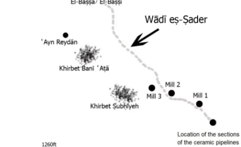
This paper studies and documents a series of rapidly disappearing water installations located within the Wādī eṣ-Ṣader region, which is located to the southeast of Wādī Moūsā and forms the main entrance to the world heritage site of Petra (Figures 1 and 2).
1 We wish to express our gratitude to John Bernard Winterburn for helping in proofreading this paper.
2 Independent scholar.
3 This work was conducted in December 2017 by the Cooperative Society of ʿAyn eṣ-Ṣader.
The rapid urban expansion and population growth are principal threats to the archaeological resources of Wādī Moūsā. Because those resources are located within privately owned lands, they are heavily disturbed by the land use and the un-moni- tored construction and development activities. Some of them will be threatened with potential future urban expansion. Sadly, such sites are destroyed without being inves- tigated and documented.
Despite the huge efforts made to reveal the mysteries of the heritage site of Petra, limited efforts were made to study the archaeology of Wādī Moūsā, which represents one of its vital and important suburbs. The lack of our understanding of the archaeology and ancient history of Wādī Moūsā may be attributed to many fac- tors such as the rapid rural expansion of this town which was built over an older vil- lage whose exact date of construction and use is only vaguely known.
Wādī Moūsā prospered during the Nabataean period in particular. Significant traces of extensive occupation dated to different periods have also been uncovered and these include architectural remains, various types of archaeological artefacts and installations as well as inscriptions (‘Amr et al. 2000: 247–249; ‘Amr and Al-Momani 2001: 268; Al-Salameen and Falahat 2012).
The availability of water sources as well as the suitability of the soil for culti- vation made the economic activity traditionally based on agriculture and livestock.
The area today has many springs which are used to irrigate the fields scattered through- out the wādī, cultivated with olive, vines, pomegranate, apricot and other trees. One of the main springs in the town is the one at the entrance of Wādī Moūsā which was the major source that provided the town and Petra with some of their water require- ments between the Nabataean and the Islamic periods.
Literature Review
Although considerable research has been devoted to investigating the history and ar- chaeology of Petra, less attention has been paid to Wādī Moūsā. Some limited infor- mation about the ʿAyn eṣ-Ṣader region is found in the narratives of the visitors to Wādī Moūsā during the recent two centuries. The Czech explorer Alois Musil (1907:
42) mentioned this area when he visited Wādī Moūsā in 1896, but did not provide any information about it. The Palestinian explorer and writer Taufik Canaan, who visited Wādī Moūsā in 1929, did not mention ʿAyn eṣ-Ṣader. He mentioned that Banī ʿAṭā, who dwelt and are still dwelling near ʿAyn eṣ-Ṣader, pitched tents ‘on the moun- tain Redan [Reydān] and use the water of the spring bearing the same name’ (Canaan 1929: 161).
In the 1920s Sheikh Ḥamzah al-ʿArabī, a judge from Maʿān, visited Wādī Moūsā and Petra. His descriptions and documentary narratives are preserved in an unpublished manuscript entitled Waqfah bayn al-athāar (‘Tour among the ruins’). He listed ʿAyn eṣ-Ṣader among the major springs in the region and said that the spring is located on al-Ḥattah road, in an area called al-Farʿ and continued ‘that its waters are abundant, but with quantities less than those of ʿAyn Moūsā’ (al-ʿArabī n.d.: 81–82).
Figure 1. Map showing the distribution of sites located along Wādī eṣ-Ṣader
Figure 2. Map showing the study area
Another visitor to Wādī Moūsā was Nelson Glueck, in May 1934, when he was conducting comprehensive surface explorations in the southern Levant. He visited eṣ-Ṣader region and identified some sites and these included the ‘the large, feature- less ruined site of Khirbet el-Mehalleh [Banī ʿAṭā]’ where he noted a number of Nabataean and a small quantity of medieval pottery sherds. He visited ‘Ain Gheidan’
(sic) (ʿAyn Reydān) as well as Khirbet Sabhiyeh ‘Ṣubḥīyeh’ overlooking Wādī eṣ- Ṣadr from the south. This site was, according to him, ‘a small ruined site, being little more than a large heap of stones, with nothing about it to help establish its identity’.
In addition, Glueck explored several sites distributed to the south and southeastern regions of eṣ-Ṣader, such as Khirbet Sarah [Bīr Sāra], Wādī Suwakh [Eṣ-Ṣewāḫah], ʿAyn Hejim, Khirbet Dahahah [Dḥaḥah], Khirbet el-Minyeh and ʿAyn el-Far’ah [al- Farʿ] (Glueck 1935: 77–87).
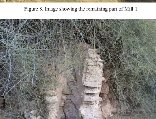
The archaeological salvage survey and excavations of the Wādī Moūsā Water Supply and Wastewater Project conducted in the 1990s revealed the following re- mains within the vicinities of ʿAyn eṣ-Ṣader: Khirbet Banī ʿAṭā with evidence of occupation during the Byzantine and Islamic periods, Khirbet Ṣubḥīyeh which pro- vided another evidence of Nabataean and Islamic occupation, ʿAyn Reydān where a Nabataean reservoir was constructed and restored in later periods in addition to a water mill located close to the spring (see Mill 1 in Figure 8) (‘Amr and Al-Momani, Unpublished Report; ‘Amr and Al-Momani 2001: 268).
Like other local traditional villages in Wādī Moūsā, the Banī ʿAṭā village, which was named by Glueck Khirbet Mehallah [El-Maḥallah] (1935: 108), was built over an earlier village whose exact date of construction is not entirely clear, and was rebuilt again during the Late Ottoman period. Although the village is partially de- stroyed, the remains of Nabataean dressed stones, pottery fragments dated to differ- ent periods, and olive-oil press crushing stones are still visible. Additionally, a Na- bataean inscription referring to the presence of a rb mrzḥʾ ‘Head of Symposium’ in Wādī Moūsā was also found in this Khirbet (Al-Salameen and Falahat 2012).
Below, we are discussing in detail the hydrological and agricultural installa- tions and remains that are visible in the study region and which are rapidly threatened by human activities and urban expansion. These include the sections of the terracotta pipeline that have been recently uncovered close to the spring and the Islamic period water mills.
In addition, the ancient names of sites located within this valley will be identi- fied and analysed, including those that originated from Aramaic and those that are at- tested in the Petra archive. Finally, terraces built on both banks of Wādī eṣ-Ṣader will be explored and the oral narratives pertaining to water traditions in the region will be presented.
Nabataean Hydrological Remains
Archaeological studies have concentrated on the hydrological systems invented and adopted by the Nabataeans to manage water sources in Petra. Attention was focussed on the canalisation system that provided Petra with its needs of water and the channel
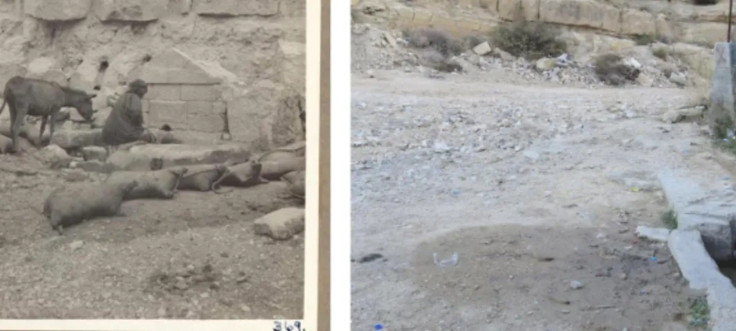
Figure 3. ʿAyn eṣ-Ṣader in 1930 (left)4 and in 2018 (right)
that brought water from ʿAyn Moūsā to Petra through the Sīq aqueduct (Bellwald 2007: 317). The Greek archive found in Petra mentions other springs in Wādī Moūsā and these include: αλ-Βασσα = El-Baṣṣa/ El-Baṣṣī, Αιν αλ-Εις = ʿAyn al-ʿEis and Αιν Βορακον = ʿAyn Brāq (Papyri numbers 36: 121, 140; 17: 162). ʿAyn eṣ-Ṣader is not mentioned in the archive or any other historical document. In addition, no Nabataean hydrological remains have been previously recorded from the spring region.
The quantities of water coming from the spring have been rapidly decreasing during recent decades. This spring, which is located at the height of 1191 m above sea level, today provides an average of 6.75 cubic metres per hour. The spring’s water table fell below ground level and the Springs’ Cooperative Society decided to dig in particular areas within the vicinity of the spring to access groundwater in underground aquifers. As a result, remains of smashed Nabataean water terracotta pipeline were uncovered in the southeastern bank of the wādī, west of the current running spring.
No remains of this pipeline have been traced in other parts of the wādī.
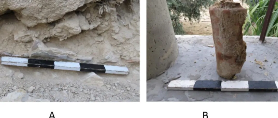
Two parts of Nabataean terracotta pipeline were found as a result of this uncon- trolled and unmonitored work: the first one represents a small fragment that was re- moved by the bulldozer (Figure 4 B). The fragment, which has lime encrustation on the interior, is 30 cm long and its diameter is about 15 cm. The second part of the channel is still in situ (N 30.31054°, E035.48633°, elevation 1191 m above sea level).
It is running northeast, south-west, and the remaining length of the channel is 70 cm (Figure 4 A). Its diameter could not be measured, since more than half of the pipe is still hidden under a collapsed rock. These are typically similar to the Nabataean pipes that were uncovered while conducting the Wādī Moūsā Water Supply and Wastewater Project (for comparisons, see ‘Amr and Al-Momani, Unpublished Report; Ruben 2003: 56–58).
4 https://www.facebook.com/234290910054178/photos/a.234297203386882.1073741828.
234290910054178/238494292967173/?type=3&theater (last access: 22 April 2019).
Figure 4. Remains of water channel (pottery pipe) that is still in situ (left), and fragment of a pottery pipe (right)
On the opposite side of the Wādī where these pipes were found, there is an- other modern channel that runs in the same direction and was erected over another earlier channel that was used to feed a water mill during the Mamluk-Ottoman period.
This provides strong evidence that there were two water channels emerging from eṣ- Ṣader spring. This tradition was common during the Nabataean period when double aqueducts were used to control the waters of the springs, and these consist of a terra- cotta pipeline and a gravity flow channel (Bellwald 2007: 317).
It seems that this terracotta pipeline was constructed to provide water for do- mestic and drinking uses. Villagers mentioned that the waters of this spring were pro- viding the whole Wādī eṣ-Ṣader region with its needs of water and its supply reached the region northwest of El-Baṣṣa/El-Baṣṣī spring, more than 1 km long. Villages were seemingly constructed mostly overlooking the wadi from its southern side. It appears that the remains of the traditional villages, constructed during the late Ottoman period, were built over earlier structures. It was in Banī ʿAṭā village, which was named by Glueck as Khirbet Mehallah, that ‘Nabataean and medieval Arabic sherds has been noted’ (Glueck 1935: 100). A considerable number of Nabataean dressed stones were used in the construction of the village where a Nabataean inscription was found as we stated earlier. In addition, informants mentioned that while reconstructing the village in the early 19th century, a mosque miḥrāb was found,5 which indicates that the current mosque was evidently built over an older one whose exact date of construction in unknown.
The original site’s disturbance, from the construction of new buildings one and a half centuries ago, makes it difficult to assess the association of some scattered arti- facts with specific buildings, such as the olive oil presses’ fragments that were used in the construction of some of the village walls.
5 Personal information from Abū Ghāzī (2008).
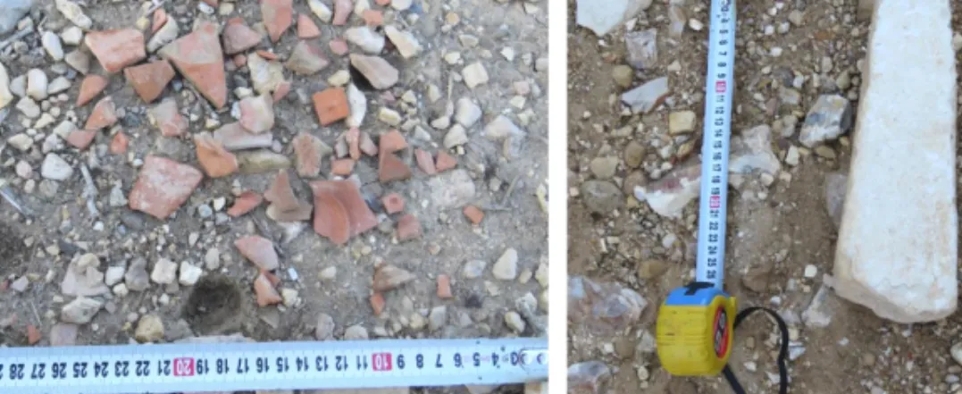
Figure 5. Nabataean pottery fragments found in one spot (left) and photo of the nefesh (right) About 1 km east of this village is Khirbet Ṣubḥīyeh which partly survived and is surrounded by modern buildings. Glueck visited the village area and said: ‘it is a small ruined site, being little more than a large heap of stones, with nothing about to help establish its identity’ (Glueck 1935: 77). The current traditional village was built in the mid-1950s and is the most modern traditional village in Wādī Moūsā.
This is the last Khirbeh in the study region to have been built and abandoned. The sur- viving buildings were constructed of dressed stones, some of which reflect Nabataean chiselling techniques.
The agricultural terraces constructed on both sides of Wādī eṣ-Ṣader are either ancient or recently modified and constructed. Quantities of Nabataean pottery frag- ments have been noted within the orchards (Figure 5), which indicate that these areas witnessed a kind of residential activity, beside practicing agriculture. No other Na- bataean remains were found there because of the continuous use of these terraces.
One exception is a fragment of a Nabataean uninscribed tombstone nefesh within the wādī, which was carried down to this area by flood waters running in the valley during the rainy seasons (Figure 5).
Toponyms
The archaeological remains indicate that the whole region overlooking Wādī eṣ-Ṣader from the south was inhabited during the Nabataean to the late Islamic periods. Since the houses of the village are privately owned, it is difficult to conduct any intensive archaeological explorations there, but the scattered pottery fragments within the vicin- ity of the village are dated to those periods.
The archive contains several toponyms and oikonyms located in Wādī Moūsā, Petra, Augustopolis (Udhruḥ?) and Ṣadaqah, and most of them are yet to be identified.
These include names of springs never referred to before. It is worth recording that several sites mentioned in the papyri are still used by the local inhabitants. Some of
the springs mentioned in the archive provided the city of Wādī Moūsā with water during the Byzantine and probably the Nabataean periods.
The naming of places is a deeply rooted tradition that may be traced back to the earliest times of human existence on earth. It is, in fact, a powerful vehicle for promoting identification with the past and locating oneself within wider networks of memory (Alderman 2008: 195), as toponyms provide us with valuable linguistic, social and urban facts as well as historical information. The naming of places is linked mostly with natural and cultural factors. Toponyms are generally assigned to describe topog- raphy, flora and fauna, natural resources, social and cultural events, folkloric and local cultural traditions and practices.
A recently published study which recorded 140 place names in Wādī Moūsā has revealed that about 25% of those names reflect Aramaic influence and origin (Al- Salameen 2016). The Aramaic features that appear in the place names are not re- stricted to this region, but are common throughout the Levant.
It is evident that some Aramaic place names were transformed from their original shape under the influence of Arabic, but some of them still sound like words of Aramaic roots and pronunciation.
In addition, a Greek archive was discovered in the Petra church in 1993. It forms a corpus of papyrus documents written in Greek and dating to the 6th century AD, dealing with agriculture and land ownerships in Petra and the surrounding areas during the Byzantine period. The Byzantine scrolls uncovered inside the Petra church indi- cate that ‘the Nabataean tradition was at least still alive in Petra during the sixth century (…) it seems that the Nabataeans did not disappear from Petra by the fourth century. Probably they adjusted to the subjection to Roman rule, adopted Greek as the official language, and converted to Christianity, but maintained enduring elements of Nabataean identity, culture and language-names, at least’ (Frösén 2004: 143).
The Semitic materials studied in the Petra papyri have revealed a significant number of certain or possible borrowings from Aramaic, and these include place names that are still in use today, such as al-Baṣṣā, Kappā and Marbaṣ (Al-Jallad et al.
2013: 23).
The study of the recorded toponyms has shown that several place names in Wādī Moūsā have Aramaic and Canaanite roots, and many of these names continued to be used by the local inhabitants. It is evident also that some of them underwent slight modifications. These names were probably being used during the Nabataean period and continued to be used during the Byzantine and Islamic periods and are still used by the inhabitants of this region.
Below is a discussion of ancient toponyms that are mentioned in the Petra ar- chive and those which are of Aramaic origin. These were seemingly known and used during the Nabataean to the Byzantine periods and still have the same names today.
1. El-Wisīyeh (N 30.31911°, E035.47684°). This name was given to the area where a water channel coming from Wādī eṣ-Ṣader is running. This toponym may be typically compared with the Aramaic word
הייסוא
that means ‘landed property, estate’ (Sokoloff 1992: 40). The word occurs in the Jewish Palestinian Aramaic of the Byzantine Period and is attested also asאיסוא
in TalmudicAramaic (Jastrow 1903: 30) and as
ܐ ܘܐ
in Syriac indicating the same meaning (Payne-Smith 1990: 7).2. ʿAyn Amm Eʿlays: in papyrus number 36 in the Petra archive, which is a draft of a division of property written in Petra, the toponym Αιν Μοελοις is attested.
The name is associated with another water spring Αιν Βορακων (Arjava et al.
2007: 36, line 121). Αιν Μοελοις is to be compared with ʿAyn Amm Eʿlays, a shallow spring that is still running on the southern side of Wādī eṣ-Ṣader (N 30.31190°, E035.48229°), approximately 100 m to the north of Khirbet Ṣu- bḥīyeh. Its name is seemingly derived from the Arabic root ʿalas, meaning
‘drink’ (Ibn Manzour, ʿalas).
Αιν Βορακων may be linked with ʿAyn Brāq, which is located below the street leading from the village of Wādī Moūsā to Ṭaybeh. The aqueduct of ʿAyn Brāq provided the southwestern quarter of Petra with drinking water (Bellwald 2007:
319). Within the vicinity of the spring there are architectural remains that indi- cate the presence of a huge Nabataean religious building.
3. El-Baṣṣa/El-Baṣṣī (N 30.31678°, E035.47927°). It is located at the eastern bottom of Wādī eṣ-Ṣader, about 1 km to the east of the spring. Its name is also mentioned in the Petra Greek papyri in the form of βαϲϲα = baṣṣah. The word should probably be connected with Aramaic biṣṣā which means ‘waterlogged ground’ (Al-Jallad et al. 2013: 33). In this site, which lies not far away from the modern downtown of Wādī Mūsā, there is an ancient water spring which is still running. A section of water pottery pipe running to the west was noticed during the construction of a modern house about 100 m from the spring.
4. Eṣ-Ṣrārah (N 30.31411°, E035.48143°). This site, which is located in the western part of Wādī eṣ-Ṣader, is characterised by scattered pebbles and stones on the surface, which indicates that this word is of Aramaic origin. The word may be compared with the Jewish and Talmudic Aramaic word
רורצ
whichmeans ‘pebble’ (Sokoloff 1992: 469; Jastrow 1903: 1300). The word رارص is also used by the local inhabitants to give the same meaning.
5. Eg-Gelgleh (N 30.31713°, E035.48074°). This site is located on the western side of Wādī eṣ-Ṣader. It is derived from the Canaanite and Aramaic word
ללג
meaning ‘to roll’. The word glgl is attested in Palestinian Aramaic to mean ‘to roll around’ (Sokoloff 1992: 129). Glgl is attested also in Canaanite with the meaning of ‘wheel’ (Hoftijzer and Jongeling 1995: 222). A similar name Galgala is attested frequently in the Nabataean papyri referring to a site near the Dead Sea (see for exampleYadin et al. 2002: P. Yadin 2, P. Yadin 3 and P. Yadin 6).
6. Sarg (N 30.31591°, E035.48069°). The site is located near Eg-Gelgleh, over- looking Wādī eṣ-Ṣader from its northwestern side. The name seemingly derived from either the Arabic word (sarg = saddle) or (šarg = watering hole) (Al- Jallad et al. 2013: 47). Double named sites consisting of the word Sarg are attested in the Petra archive such as Ϲ̣αργ Βενι [and Ϲεργ Νοφφ(α) which may be spelled also as Ϲεργ Λαφφα or Ϲοργ Λοφφα (Al-Jallad et al. 2013: 47).
7. Finally, in papyrus number 30, which talks about the division of an estate in Petra and dated between September–October AD 579–581, the toponym
ελ Δαργαθ = el-Dargath is mentioned twice (Arjava et al. 2007: 30, lines 48, 81). The state of preservation of the papyri is poor and it is not clear whether this site is located in Petra or Augustopolis [Udhruḥ?]. If this divided property mentioned in the document was in Wādī Moūsā, it might have been used to refer to ed-Draigah that is located approximately 300 m west of ʿAyn eṣ-Ṣader.
The Greek word derived from the Arabic root darag, ‘step, stair’, and the site was given this name because of its stepped terraces.
It is worth mentioning that there is another site in Wādī Moūsā called ed- Daragah, located north of the downtown. Salvage archaeological works in this site have yielded pottery objects and fragments of ceramic pipes from the Na- bataean period. We are not able to confirm which one of these is referred to in the Petra archive (‘Amr and Al-Momani, Unpublished Report).
It is apparent that these names were known and used over a long period of time, and all of them are currently parts of agricultural fields and orchards. It is evident clearly that Wādī Mūsā was an important agricultural area within the suburbs of Petra during the Nabataean and Byzantine periods as indicated by the Petra church archive and the use of some Aramaic names. Wādī eṣ-Ṣader, which is considered an important source of water as early as the Nabataean period, seemingly contributed to the agricultural economy of Wādī Mūsā through ages.
Islamic Water Mills
Water mills were common throughout the inhabited part of Transjordan during the medieval and late Islamic periods (Al-Malkawi 1994). These installations, which were used for grinding grain, were built in a huge number of sites in the Levant during the Islamic periods.
In his study of the public utilities in Transjordan during the Ayyubid, Mamluk and Ottoman periods, which was based primarily on the Ottoman archives, law court registers and the Jordanian cadastral documents, al-Bakhit listed two water mills in Wādī Moūsā: al-ʿAlāyā which was operated by ʿAyn Moūsā and Banī ʿAṭā and Esh- Shroūr Mill which is located near eṣ-Ṣader spring (Al-Bakhit 1993: 60) and operated by water pressure coming from this spring. Ottoman records mention that the government imposed between 30–60 Akche (akçe)6 per mill per annum (Al-Bakhit 1993: 56).
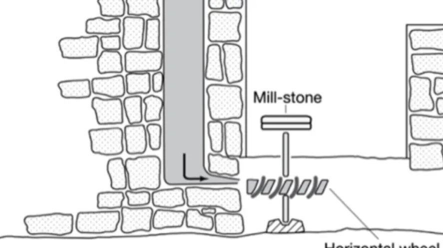
Generally speaking, water mills are divided into two main categories (McQuitty 1995: 747): vertical-wheeled mills, which use gearing equipment to connect the wheel with horizontally placed millstones, and horizontal-wheeled mills which are directly connected with horizontal millstones. Like other mills found in the southern Levant, the Wādī Moūsā mills belong to the horizontal-wheeled category (Al- Malkawi 1994: 20–40). The main principle of this mill is to extract power from the flow of water, which is normally directed towards the paddles of the wheel, which operates the millstones and grinds cereals (Figure 6).
6 It was the main monetary unit of the Ottoman Empire.
Figure 6. Drawing of a mill with an arubah penstock (McQuitty 1995: 199: fig. 2) The water mills consist of the following parts: two water channels: one carries water to the mill and another one which carries the leaving water outside the mill, in addi- tion to a horizontal wheel (wooden or metal) and a grinding room.
No comprehensive and documentary study, however, has been conducted on the Wādī Moūsā water mills. The aim of the following section is to set up a prelimi- nary documentation of the water mills constructed along Wādī eṣ-Ṣader and to pro- pose a tentative date of their construction and use. Before discussing the mills, it is useful to list all the ancient water mills in Wādī Moūsā, the remains of which are still visible. Mills are concentrated in the following areas:
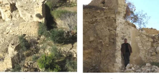
1. Remains of three mills are still visible near ʿAyn Moūsā. Two of them, which are connected to each other, were constructed approximately 700 m west of the current water source, northeast of an-Nawāfleh village (Figure 7 A) (N 30.32673°, E035.49123°). The third one was built about 500 m to the east (N 30.32509°, E035.49669°), (Figure 7 B). This was seemingly provided from another water source opposite the current water source. This was originally a double mill, similar to the previously mentioned mills, but it has been recently partially destroyed (‘Amr and Al-Momani 2001: 264).
2. Remains of three mills were recorded near al-Ramlah [Zurrābah] water reser- voirs, not far away from the main entrance of Petra, and a millstone of one of these mills was noted earlier in the mid-1980s (al-Muheisen 2009: 41–42), (N 30.32684°, E035.46831°). The date of their construction in not entirely known, but from their constructional techniques it seems that they were linked with the construction and use of the reservoirs between the Nabataean and Byz- antine periods. In addition, there are a few remains of another mill opposite these reservoirs, close to the Petra College for Tourism and Archaeology.
3. In total there were three sites with remains of water mills recorded in the Wādī eṣ-Ṣader area. Villagers reported that these mills were not functioning during the recent two centuries, a time when other mills located near ʿAyn Moūsā were
Figure 7. Images of ʿAyn Moūsā mills
operating. Water for these three mills was tapped from the main spring located to the east, and conduits provided water to these installations running east–
west. The original conduits no longer exist.
The following is a description of the remaining parts of these three water mills:
Mill 1 (N 30.31097°, E035.48598°, elevation 1186 m above sea level) (Figure 8) This is the nearest mill to the water source and fed with water from its western side.
The original conduit that was providing this mill with water has been washed away because of the subsequent floodings, as it is directly located on the northern bank of the wādī. During the previous century, another channel was constructed to bring water along the same direction and it seems that this channel replaced an older one. Only part of the tower has survived. The diameter of its internal part is 60 cm, and its re- maining height is 186 cm. The thickness of the remaining parts of the tower is be- tween 30 and 40 cm. No wheels or millstones were found in the vicinity of the mill.
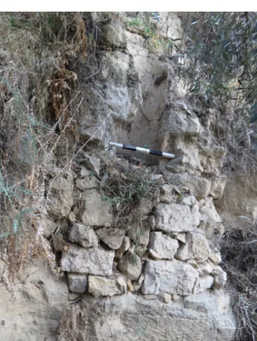
Mill 2 (N 30.31179°, E035.48425°, elevation 1151 m above sea level) (Figure 9) This mill, located in an orchard owned by Ahmad al-Fdoul, is found about 170 metres west of Mill 1. The internal diameter of the tower is 50 cm, and the thickness of the remaining parts of the walls is between 40 and 50 cm, meanwhile the remaining height is 230 cm.
There are no remains of a water channel near the mill and the fields are cur- rently provided with channels that were built below the mill. Only part of the tower is still visible and its lower parts are below ground level. This gives an indication that the current floor level was deposited and formed over centuries as a result of floodings.
Figure 8. Image showing the remaining part of Mill 1
Figure 9. Image showing the remaining part of Mill 2
This is indicated by the location of the mill at the edge of the northern bank of the wādī. Besides, the alluvial deposits were accumulated as a result of the flooding that formed the terrace where this mill was built. It seems, therefore, that this is probably the oldest mill in the Wādī eṣ-Ṣader region.
Mill 3 (N 30.31193°, E035.48304°, elevation 1179 m above sea level) (Figure 10) This mill, which is located in an orchard owned by Ali Al-Salameen, is located about 220 m west of Mill 2. It is the smallest in our group of mills and was provided with water from a channel that runs to the south; the water is still running via a recently modified channel in the same place. Only part of the tower of this mill is still visible in addition to another stone construction that was built in front of the tower.
The internal diameter of the tower is 32 cm, and the thickness of the remaining parts of the walls is between 30 and 45 cm, while the remaining height is 100 cm.
Figure 10. Image showing the remaining part of Mill 3
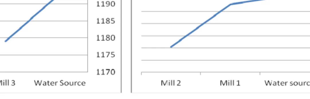
Figure 11. Figure showing the slope of the water from its source to the mills
The extant water mills in Jordan are all of the horizontal-wheel type (McQuitty 1995:
747–748). Like other mills found in Jordan, these mills were driven by water from the nearby conduits then into an arubah penstock, a tube that delivers water to a horizon- tal turbine wheel connected by a straight shaft to grinding stones (Greene 1995: 759).
These mills, which are currently in an advanced state of decay, were built of local limestone blocks mortared together. The mortar was reinforced sometimes by pottery fragments. All the internal parts of the mills such as the millstones and the tur- bine wheels are missing.
The spring is approximately 1191 m above sea level, while the mills are be- tween 1151 and 1186 m (Figure 11). In order to guarantee sufficient power of water, mills were constructed below the level of the spring.
Dating these mills is a problematic issue. They are definitely dated to the me- dieval and late Islamic periods, but giving an exact date of their construction and use is problematic. Several points are worth mentioning here to establish a probable ten- tative date of the construction of these mills:
1. These mills are located beside wadis that witnessed seasonal floodings or inside ploughed agricultural fields. No datable pottery, therefore, was found within the vicinities of the mills. Pottery fragments have been noted within the or- chards in other parts along the wadi and these are dated to the period between Nabataean to late Islamic periods.
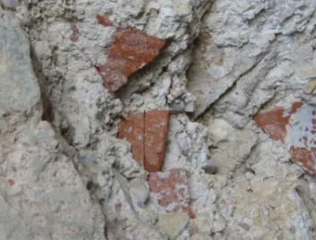
2. In Mill 2, the mortar used to construct the mill included pottery fragments that are dated to Nabataean and Byzantine periods (Figure 12). The date of the con- struction of the mill is to be definitely after this date. In addition, it seems that a considerable part of this mill is still hidden in the ground, which means that the terrace on which the mill was constructed was deposited and formed over a long period of time. Besides, the current water supply system, which was de- signed during the Ottoman period, is not connected with this particular mill.
All these hints give indications that the mill was constructed between the early Islamic and the Mamluk periods. A comparative study shows close similarities between this mill and those scattered in ʿAjlun–Kufranjah dated to the late Mamluk early Ottoman periods (Greene 1995) and these include the construc- tional techniques as well as the similar size and shape of the towers.
Figure 12. Image showing the pottery sherds that were mixed with the mortar applied to Mill 2
3. When did these mills cease to operate? The answer was found in an interview made by Hani Falahat in 1998 with ʿAṭīyeh al-Masāʿdeh who was born in Wādī Moūsā in 1890. He said that by the late 1800, the Sheikhs of Banī ʿAṭā and Esh-Shroūr went to the Ottoman governor in Maʿān and they complained and tried to convince him that they did not have a mill to grind their cereals.
He decided accordingly to divide the two mills that were operated by the waters of ʿAyn Moūsā as follows: the upper one to al-ʿBeydīyeh and al-ʿAlāyā and the lower one to Banī ʿAṭā and Esh-Shroūr. After the Revolt7 al-ʿBeydīyeh and al-ʿAlāyā got rid of Banī ʿAṭā and Esh-Shroūr’ (1998). This gives an indication that eṣ-Ṣader mill (Mill 1), which was mentioned in the Ottoman records, was not operating at this time.
4. The Ottoman records mentioned that the Banī ʿAṭā and Esh-Shroūr mill (Mill 1) were taxed (Al-Bakhit 1993: 60). Mills 2 and 3 do not appear in these re- cords, they may have been operating before that time. They were likely con- structed and used during the Mamluk period.
These mills are simple constructions. The tower was built of different small and me- dium sized blocks, mixed with mortar and pottery and then the interior part of the tower was plastered and mortared to form a cylindrical shape.
One of the villagers interviewed talked about the regular maintenance of the ʿAyn Moūsā mills during the Late Ottoman period. This gives insights on how they were constructed. He said that the tower was built normally of dressed stones which were joined together with a mortar known as el-Ḥumrah. This is special clay, reddish in colour, available naturally in special places such as the area around ʿAyn Moūsā.8
7 This refers to the Great Arab Revolt that took place in 1916.
8 Personal information from Abū Gharīeb (1998).
This kind of mortar was mostly used as a joint material in the mills due to its ability to prevent leakage and seepage. The dimensions of the mill tower vary and the floor of the tower and other parts of the mill were originally paved with flagstones.
Another room was then built in front of this tower. It contained mill stones as well as a horizontal turbine wheel that was connected by a shaft to the millstones.
The towers were normally fed by aqueducts descending to the mill located lower than the water source, which helps to increase the flow of water. These conduits bring water to the turbine wheel via a tower. The other channel carries the water out- side and away from the mill after passing across the turbine.
The interior walls were covered with plaster similar to the one that was used by the villagers during the Late Ottoman period. Knowing how these mills were maintained and re-plastered gives an indication of how they were manufactured. Abū Gharīeb, a skilled local architect says ‘the wall plaster consists of a mixture ṣamagah and hay. This was covered sometimes with a white paint called beyāẓah, which was produced normally in special lime kilns that were used to produce lime to be used to whitewash buildings. Kilns were normally located outside the settlements, constructed in the ground, filled with wood which was burnt below the lime blocks. After burn- ing, which makes the lime blocks so fragile, it was taken outside the kiln to be mixed with water, stirred and carried in leather sacks to be used thereafter’.9
To conclude, the existence of these water mills confirms that cereals were of vital importance in the diet of the local community. Judging by the number of water mills recorded in the study area, it is likely that this area witnessed remarkable agri- cultural production. These installations were constructed to fulfil the needs of the lo- cal community of Wādī Moūsā and the surrounding areas and were most likely not used for export.
The ownership of the mills may be inferred by their names as they were owned by certain tribes, but they were probably used by all the inhabitants of the village.
Existing Terraces and Agricultural Patterns
Terraces are one of the most prominent agricultural features of Wādī Moūsā. They were constructed along the banks of Wādī eṣ-Ṣader to cultivate different kinds of trees. Their length varies; some were built in a single row of stones and others were constructed of two lines filled with gravel.
Terraces are identified as ‘artificially flattened surfaces on which crops are grown subsequent to the flattening, no matter how small, how crude, or how purpose- ful’ (Spencer and Hale 1961: 3). The major problem when studying the ancient ter- races is that it is not possible to set a clear chronological sequence of these construc- tions, since they were used and reused over a long period of time. Presenting a typo- logical study of these terraces is problematic, as such studies are based principally on
9 Personal information from Abū Gharīeb (1998).
Figure 13. Remains of an ancient terrace on the southern bank of the wādī
the particular field’s morphology. Some of the stones of these terraces were dressed and sometimes there is a space between the two rows of the walls, filled with earth and gravel. Walls were built along the valleys in terrace-like shape and filled with soil and gravels from the upper parts (Figure 13).
The Wādī eṣ-Ṣader terraces, however, could not be attributed to a particular period of time, but have been continuously used up to modern times. It seems that the residents of the area depended mainly on the irrigated agriculture in these fields, which played a vital role in supporting their agricultural economy.
Generally, the functions of the terraces are to (Treacy and Denevan 1994: 93–
95; Zohary 1954: 20):
1. transform the slopes into a series of level surfaces which allows water percola- tion into the soil to minimize runoff;
2. control erosion; Terracing reduces soil erosion and enhances the accumulation of soil and water;
3. control moisture and to facilitate the transport and distribution of irrigation water;
4. clear stones; this process allows plant roots to seek stored moisture from far below the earth’s surface deep down.
Inherited Irrigation Traditions
The information provided below is based primarily on several interviews recorded in 1998 with elderly villagers. It is a commonly held opinion that oral narratives, which were handed down through generations, are rich sources for explaining diverse issues related to the topics presented in this paper.
Agriculture was the mainstay of Wādī Moūsā's economy throughout history, and its development was facilitated by the abundance of water, the adequacy of the climate and the suitability of the soils for agriculture. The springs were important sources on which the farmers in the region relied throughout the ages. They were numerous, and their water was used in daily life and to irrigate the cultivated crops and trees.
The inhabitants of Wādī Moūsā had special inherited water traditions, and it seems that many of these traditions are inherited from the Nabataean era at the very least. The people of Wādī Moūsā had customs and traditions associated with petition- ing for water and they have had a tradition of dividing the waters of the springs and distributing them within the rules and bases of justice till today.
In order to ensure the villagers’ irrigation rights, and to settle civil disputes re- lated to irrigation, specialised judges were appointed by the villagers to look into the relevant cases. These people are usually pious, highly respected and reliable members of the local tribes who shared the water of the region. They were known people to- tally aware of the water division principles and rules, well versed in irrigation affairs, which were based is on a well-managed and inherited programme. These judges usu- ally investigated controversial issues relating to irrigation that arose among people.
Water is divided into generally agreed assets that all people realise and abide by.
First, water is usually divided on orchards, not people, and its division is mainly dependent on the channels passing through the fields and orchards. Therefore, the course of the channel determines the land (or lands) that benefit from the water of the spring. Each water spring has, accordingly, a fixed route that cannot be changed.
A Nabataean deed of sale was found west of the Dead Sea. This includes the land and its trees in addition to the weekly irrigation timings and indicates that their turn will be for half an hour on the first day of every week forever: ‘including the irrigation-ditches and the assigned watering periods, a half of one hour on the first day of the week and every [wee]k for ever’ (Yadin et al. 2002: P. Yadin 3). It seems that this system continued during the two thousand years that followed the political end of the Nabataeans and confirms that this traditional and customary law of irriga- tion has not changed. In some of the legal documents collected by Hani Al-Falahat from the Wādī Moūsā region during the past two decades, there are several refer- ences to the importance of springs’ water and their channels when selling agricultural properties and orchards. In one document, for example, a reference to the sale of an agricultural land was associated with the sale of the share of this land in water (Al-Salameen and Falahat 2015).
Second, the water distribution timings were commonly recognised by the vil- lagers in the study area, and these were mainly based on known shady or sunny marks (ʿalamah) at specific points.
Third, the share of each plot of planted land is one year in the summer and one year the year in winter, and one year in the night and one year in the day, for consid- erations aimed at ensuring the fairness of distribution, and these justifications were based on several facts such as that the summer is longer than the winter, and the marks of the division of water may not appear in some cloudy winter days and thick fog, which may cause interference between the portions.
Fourth, the share of water is sometimes sold with the land, and the land may be sold without its water portions, but only the purchaser of the portion can use the channel that runs along that particular orchard. This tradition is also inherited from the Nabataean era. Nabataean papyrus asserted that the sale of cultivated land in- cluded the share of water and all that exists within the field of trees and canals and even wet and dry timber (Yadin et al. 2002: P. Yadin 3, lines 27–30).
Fifth, the division of water was done on a tribal basis, the divided water por- tions being called ewjāb, and to each tribe in Wādī Moūsā there is a portion (wejeb) according to the inherited tribal tradition.
Sixth, according to this traditional inherited customary law, ʿAyn eṣ-Ṣeder was provided with two channels:
1. the Ed-Draigah channel, which waters the orchards located on the eastern and western sides of the valley of the spring up to Jisr al-Falahat near El-Ji, and 2. the El-Wisīyeh channel, which waters the western and southwestern parts of
Wādī eṣ-Ṣeder. It was used to irrigate the Shweiḥeh area and beyond. The shadow and sun marks that determined its water distribution was located in the northern valley section, near the current Vegetable Market.
Conclusions
This study provides significant information that has enhanced our understanding and knowledge of the development of the social, economic and cultural history of the studied area through the ages.
The discovery of Nabataean terracotta pipeline fragments confirms that the eṣ- Ṣader spring was exploited during the Nabataean period for both domestic and agri- cultural uses. Three water mills were recorded in the study area, which were not studied previously and are about to be demolished. The main principle of these mills is to convert natural energy into power and it extracts power from the flow of water, normally directed towards the paddles of the wheel which turned them, thus operat- ing the millstones and grinding cereals.
Comparison with other contemporary water mills constructed in Jordan has shown similarities in their shape as well as constructional techniques. These water mills are similar to mills uncovered in other areas of the Levant and the inhabitants apparently followed the same Levantine techniques of agricultural production.
No preservation work has been undertaken on these mills and they have not been included in any archaeological or conservation project. Considerable parts of the mills have been demolished and they have all been totally ignored. The architectural
and material culture evidence of the late Islamic period is threatened with demolition, as the current Jordan Law of Antiquities does not consider them as ‘Antiquities’.
Updating and ensuring a better implementation of the law is a vital need. Sadly, the Jordanian Law of Antiquities no. 21 for 1988, Article 2 states: ‘An antiquity is defined as any object, whether movable or immovable, or a part of the soil, which has been constructed, shaped, inscribed, erected, excavated or otherwise produced or modified by human agency earlier than the year 1700 AD together with any part thereof which at a later date has been added, reconstructed or restored’. These significant remains most of which are dated after 1700 AD are not considered ‘antiquities’ according to the current Antiquities Law.
In conclusion, oral history should be an integral part of any heritage, historical and archaeological research. There are several intangible cultural heritage materials from this period that are worthy of recording. These are disappearing gradually due to the rapid urban expansion and population growth.
References
ALDERMAN, Derek 2008. ‘Place, Naming, and the Interpretation of Cultural Landscapes.’ In: Brian GRAHAM and Peter HOWARD (eds.) The Ashgate Research Companion to Heritage and Identity. Aldershot and Burlington: Ashgate, 195– 213.
ʿAMR, Khairieh and Ahmad AL-MOMANI 2001. ‘Preliminary Report on the Archaeological Compo- nents of the Wadi Mousa Water Supply and Wastewater Project.’ Annual of the Department of Antiquities of Jordan 45: 253–285.
ʿAMR, Khairieh, Ahmad AL-MOMANI, Nayef NAWAFLEH and Saleh NAWAFLEH 2000. ‘Summary Results of the Archaeological Project at Khirbat an-Nawafla/Wadi Mousa.’ Annual of the Department of Antiquities of Jordan 44: 231 – 255.
ʿAMR, Khairieh and Ahmad AL-MOMANI n.d. Unpublished Report (Wadi Musa Water Supply and Wastewater Project Area). Petra Antiquities Archive.
AL-ʿARABĪ, Ḥamzah n.d. Waqfah bayn al-athāar [Tour among the ruins]. (Unpublished manu- script.)
ARJAVA, Antti, Matias BUCHHOLZ and Traianos GAGOS (eds.) 2007. The Petra Papyri III. Amman:
American Center of Oriental Research Publications.
AL-BAKHIT, Mohammad Adnan 1993. ‘Al-marāfiq al-ʿāmah fī manṭiqat sharq al-urdun (al-yanābīyʿ, wal-ābār wal-birak waṭ-ṭawāḥīn wal-maʿaṣer) [The public utilities in Transjordan (springs, wells, cisterns, mills and olive oil presses)].’ Mut'ah Lilbuhuth wal-Dirasat 8/1: 11– 68.
BELLWALD, Ueli 2007. ‘The Hydraulic Infrastructure of Petra – A Model for Water Strategies in Arid Land.’ Studies in the History and Archaeology of Jordan 9: 315 – 324.
CANAAN, Taufik 1929. ‘Studies in the Topography and Folklore of Petra.’ Journal of the Palestine Oriental Society 9: 136– 218.
FRÖSÉN, Jaakko 2004. ‘Archaeological Information from the Petra Papyri.’ Studies in the History and Archaeology of Jordan 8: 141 – 144.
GLUECK, Nelson 1935. ‘Explorations in Eastern Palestine, II.’ Annual of the American Schools of Oriental Research 15: 1 – 202.
GREENE, Joseph A. 1995. ‘The Water Mills of the 'Ajlun-Kufranja Valley: The Relationship of Technology, Society and Settlement.’ Studies in the History and Archaeology of Jordan 5:
757 – 765.
HOFTIJZER, Jacob and Karel JONGELING 1995. Dictionary of the North-West Semitic Inscriptions.
Leiden: Brill.
IBN MANZOUR, Muḥammad b. Mukarram 1956. Lisān al-ʿArab [The tongue of Arabs]. Beirut: Dār ṣāder.
AL-JALLAD, Ahmad, Robert DANIEL and Omar AL-GHUL 2013. ‘The Arabic toponyms and oik- onyms in 17.’ In: KOENEN, Ludwig, Jorma KAIMIO, Maarit KAIMIO and Daniel ROBERT
(eds.) The Petra Papyri II. Amman: American Center of Oriental Research, 23 – 48.
JASTROW, Marcus 1903. A Dictionary of the Targumim, the Talmud Babli and Yerushalmi, and the Midrashic Literature. Leipzig: W. Drugulin.
AL-MALKAWI, Mohammad 1994. Aṭ-ṭawāḥīn al-māyīeh fī wādī kufranjah fī al-ʿaṣr al-mamlūkī wa- mustahal al-ʿaṣr al-ʿuthmānī [Water-mills in Wādī Kufranjah during the Late Mamluk – Early Ottoman Period]. (MA thesis, Yarmouk University, 1994.)
MCQUITTY, Alison 1995. ‘Watermills in Jordan: Technology, Typology, Dating and Development.’
Studies in the History and Archaeology of Jordan 5: 745 – 751.
AL-MUHEISEN, Zeidoun 2009. The Water Engineering and Irrigation Systems of the Nabataeans.
Irbid: Yarmouk University.
MUSIL, Alois 1907. Arabia Petraea II: Edom. Vienna: Alfred Hölder.
PAYNE SMITH, Robert 1990. Compendious Syriac Dictionary. Oxford: The Clarendon Press.
RUBEN,Isabelle 2003. The Petra Siq. Nabataean Hydrology Uncovered. Amman: Petra National Trust.
AL-SALAMEEN, Zeyad 2016. ‘The Influences of Aramaic on the Dialect of Wādī Mūsā: A Conspec- tus.’ In: Nabil KHAIRY et al. (eds.) Studies on the Nabataean Culture II: Refereed Bulletin of the International Conference on the Nabataean Culture. Amman: The University of Jordan, 53 – 68.
AL-SALAMEEN, Zeyad and Hani FALAHAT 2012. ‘Two New Nabataean Inscriptions from Wādī Mūsā, with Discussion of Gaia and the Marzeaḥ.’ Journal of Semitic Studies LVII/1: 37–51.
AL-SALAMEEN, Zeyad and Hani FALAHAT 2015. ‘Taqalīd al-miyāh fī Wādī Moūsā wajoudhorha al- tarihīyh [Water traditions in Wadi Musa and their historical roots].’ Al-Ma’thurat Al-Sha’bi- yah Journal 89: 15 – 35.
SOKOLOFF, Michael 1992. A Dictionary of Jewish Palestinian Aramaic. [2nd ed.] Ramat-Gan: Bar Ilan University Press.
SPENCER, Joseph and Gerry HALE 1961. ‘The Origin, Nature, and Distribution of Agricultural Ter- racing.’ Pacific Viewpoint 2: 1 –40.
TREACY, John and William DEVENAN 1994. ‘The Creation of Cultivable Land through Terracing.’
In: Naomi MILLER and Kathryn GREASON (eds.) Archaeology of Garden and Field. Phila- delphia: University of Pennsylvania Press, 91 – 110.
YADIN, Yigael, Jonas C. GREENFIELD, Ada YARDENI and Baruch LEVINE 2002. The Documents from the Bar Kokhba Period in the Cave of Letters: Hebrew, Aramaic and Nabatean-Aramaic Papyri. Jerusalem: Israel Exploration Society.
ZOHARY, Daniel 1954. ‘Notes on Ancient Agriculture in the Central Negev.’ Israel Exploration Journal 4: 17 – 25.