EE OM OR PH OlO GIC Al ENO E EDE GO LQ EIC AL ESS EYS
GEOMORPHOLOGICAL
AND
GEOECOLOGICAL ESSAYS
MADEMIAI kim H iiid m
P R E F A C E
This volume includes the contributions of Hungarian physical geographers and geomorphologists to the 2nd International Conference on Geomorphology, Frank
furt, September 1989.
Since the Conference is concerned with geomorphological and geoecological topics the editorial board decided to present five papers on each main topic informing the reader about major research trends in Hungary since the First International Conference on Geomorphology in Manchester.
The papers reflect the results of traditional geomorphological research, of relief evolution, however, most of the themes are related to environment
al and dynamic geomorphological research of practical purposes. The inter
pretation facilities of aerial and space images suitable fot the interpreta
tion of numerous phenomena and processes on the Earth surface will soon pro
vide the conditions for the detection of changes in the geographical environ
ment. Besides remote sensing methods computer applications including geo
graphical information systems have become widespread also in Hungary during the last four years. Remote sensing and computer methods are considered to be the most important tools in environmental geomorphology and applied phys
ical geography serving the practical needs of regional planning, spatial organization and land use planning.
Finally, acknowledgements are expressed to the authors, translators, and editors of this volume and to all who participated and assisted at publica
tion and, last but not least, to the laboratories and experts both at home and abroad who helped our team of authors with analyses, comments or in any other way.
Budapest, June 15th, 1989
Márton Pécsi Adám Kertész
Editors
7
G e o m o r p h o l o g i c a l a n d G e o e c o l o g i c a l E s s a y s S t u dies in G e o g r a p h y in H u n g a r y , 25
A k a d é m i a i K i a d ó B u d a p e s t , 1989
R E M O T E S E N S I N G A P P L I C A T I O N I N E N V I R O N M E N T A L I M P A C T I N V E S T I G A T I O N S F O R L A N D R E C L A M A T I O N
I N A S T R I P M I N I N G A R E A ( V I S 0 N T A , H 0 N G A R Y )
J . B A L O G H , L . B A S S A , É . C S A T Ö , Z . G E R E N C S É R , G Y . H A H N , Á . R I N G E R
ABSTRACT
On the piedmont surface of the Northern Mountains, in the vicinity of the railway line between Budapest and Miskolc there is a larger lignite field with a length of 120-140 km and with a width of 8-12 km. The coal deposits dip under overburden sediments of different thickness to S, towards the Great Hungarian Plain.Due to favorable conditions of overburden removal open
cast lignite mines are to be found in the vicinity of Visonta and BLikkáb- rány. From the Visonta coal field 100 million tons have already been ex
tracted and another 100 million tons are being extracted now. At both sites several 100 million tons of lignite are known. Mining and industry occupy an area of 30 km2 at the Visonta site.
The land value before mining activity was determined and compared with the value of the stripped and recultivated land by the research team of the Geographical Research Institute of the Hungarian Academy of Sciences. It could be proved that after the exploitation of the coal resources with an in situ value of 10 billion forints the land value decreased with cca. 2 billion forints in spite of the accelerated reclamation . Methods have been elaborated to registrate the conditions of untouched resp. for mining utilized surfaces and to optimize the sequence of strata in the course of reclamation.
9
2 G e o m o r p h o l o g i c a l
GENERAL REMARKS
Mineral and fossil fuel resources located near the surface can be extracted economically using surface mining techniques. Overlying geolog
ical materials are removed in order to expose and subsequently extract a resource. These mining methodologies alter the physical environment more profoundly than the deep mining activities. Vegetation and soil cover are nearly homogenized. Steep hillslopes of spoils and depressions are produced.
Drainage networks and channels are obliterated, runoff conditions are modi
fied. When studying surfaces of strip mining, three major time periods are considered and corresponding areas distinguished (TOY, T. 3. 1984):
1. Pre-mining period, prior to the disturbance,
2. The active-mining period, during and immediately following resource extraction,
3. The post-mining period, following reclamation of the disturbed lands.
In the international practice environmental impact assessment precedes each major activity which involves environmental trasformation. Moreover, in the USA the Surface Mining Control and Reclamation Act of 1977 presc
ribes pre-mining reclamation planning. This planning process embraces five basic steps of soil reclamation and landscape reconstruction (National Research Council 1981):
1. Predisturbance inventory of soils and land productive potential, 2. Decision on post-mining land use,
3. Preparation of a reclamation plan based on the results of the inven
tory to accomplish the chosen goal,
4. Reconstruction of the soil and landscape after mining is completed, in accordance with the reclamation plan,
5. Management of the resulting soil and
Monitoring to determine success of reclamation.
THE CASE OF V IS O N T A
Along the southern foothills of the North Hungarian Mountains between Budapest and Miskolc a lignite proauctive area stretches in a length of 120-140 km E-W with a N-S width of 8-12 km. Due to a relatively high thermal value (above 7000 kO/kg) and favourable conditions of over- 10
burden removal (maximum 1:20 m/m) several of these sites offer economi
cally recoverable resources. Of the reserves at the foothills of the Mátra Mountains about 100 million tons have been extracted and also about 100 million tons are to be produced in open-cast mines, which represent 10-10 billion Forints value respectively. Annual output of the Visonta (Thorez) mine is 6-7,5 million tons and produced by three pits (NY: West, K-l: East NI, K-2: East N2). To protect surface constructions another 100 million tons of reserves had to be retained subsurface. Lands involved in strip mining and the adjacent "Gagarin" thermal power station together occupy an area of about 30 km2 (HAHN,GY. et al. 1985).
Strip mining seriously affected the adjacent region and had environ
mental and socio-economic consequences. Lands abandoned by agricultural production appeared, dewatering of the mining area reduced the ground- water table. This caused troubles in the water supply of eight surroun
ding settlements. A regional plan had to be compiled and new waterworks to be built. Air pollution by the power plant based on the lignite extracted can be observed in more than ten-kilometre zone (as it is shown by a Landsat image acquired in winter time). It damages one of the most important recreational area of Hungary — the Mátra mountains. Among the social consequences manpower problems in agriculture should be mentioned (HALÄSZ.T. 1983).
Besides the environmental and social issues surface mining and power plant siting problems embrace legal and economic criteria (TÓTH, S. 1983).
Among the complex and often interlocking assemblage of (cca 40) statutes in force the Mining Act (1960) and the Land Protection Act (1981) are the most relevant which prescribe that:
a/ In case of using cropland for other purposes the users are obliged to pay compensation, part of which is being allotted to the reclamation of areas of poor fertility.
b/ Users are obliged to reclaim areas deteriorated and return them to the farms in their original state.
An attempt has been made to assess the economic effectivity of land reclamation by the collective of the Geographical Institute of the Hun
garian Academy of Sciences .
1. The plots of the'reference area' on external spoil heap were referred to land quality classes prior to expropriation.
2. Reclaimed lands were classified on the basis of cadastral net income
11
and categories and. present land value established in gold crowns for each type of cultivation and plot.
3. Each plot and the total area were evaluated: by cultivation and quality classes as well as by gold crown values and prices of expropriation be
fore and after land reclamation computed according the Land Protec
tion Act in force.
Results are shown in Figs. 1 and 2.
Quality class
II
III
IV
V
VI
VII
VIII
0 1 5 4 /2 1
V 2
73,2 3
Fig. 1. Reference area before mining (by J. BALOGH and Z. GERENCSÉR). - 1=
plot number; 2= type of cultivation; 3= land value in gold crown per hectare; A= arable; V= vineyard; 0= orchard; F= forest; P=
pasture
For the total area 205 million forints land value was computed whereas for plots on the reclaimed surface land value totalled 11 million forints. It seems to be unrealistic taking into consideration the low differences be
tween yields achieved before and after disturbance. Calculations extended for the total strip mining area show 1.8-2.0 billion forints compensation costs to be allotted by the coal mining company, i.e. 1/5 part of the in situ value of the lignite extracted. This very high sum causes permanent debates between the mining company and collective farms, the owner of the land.
12
Quality class
Fig. 2. Reference a r e a after reclamation (by J. BALOGH and Z. GERENCSÉR). - For explanations see Fig. 1.
A new method of assessment of reclaimed lands has been elaborated by the Institute for Soil Science and Agrochemistry Hungarian Academy of Sciences, subsequently adopted by the Ministry of Food and Agriculture. Taking into consideration that the land evaluation in force is based on the genetic types of soils but genetic horizons do not occur in profiles disturbed by strip mining, this evaluation refers to parameters such as microrelief, amount of skeletal particles, textural and hyorophysical properties, identifiable horizons, soil reaction (pH) and carbonate content, humus content, hete
rogeneity and climatic conditions.
A medium-term landscape reconstruction project was developed by the Forest Survey Service of Ministry of Food and Agriculture in 1981, that is about 15 years after the mining had started in the Visonta region. As it was emphasized in this project in the future it should be attained that both mining and the reclamation plan be prepared simultaneously and entirely coordinated. It also draws attention to the necessity of complex ameli
oration and soil conservation, development of a contiguous green belt, physical planning of settlements located in the vicinity. Subsurface
13
waters are suggested to be pumped out to ensure mining activity and to be utilized properly, with water quality protected and controlled (HALÁSZ,
T. 1983).
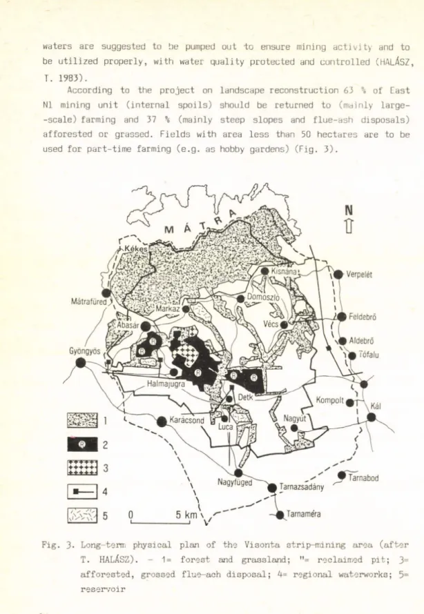
According to the project on landscape reconstruction 63 % of East N1 mining unit (internal spoils) should be returned to (mainly large- -scale) farming and 37 % (mainly steep slopes and flue-ash disposals) afforested or grassed. Fields with area less than 50 hectares are to be used for part-time farming (e.g. as hobby gardens) (Fig. 3).
Fig. 3- Long-term physical plan of the Visonta strip-mining area (after T. HALÁSZ). - 1= forest and grassland; "= reclaimed pit; 3=
afforested, grossed flue-ach disposal; 4= regional waterworks; 5=
reservoir
14
REMOTE SENSING APPLICATIONS
Aerial photos and satellite images prove to be instrumental in monitoring of the environment, especially of changes in land use (land cover). Landsat MSS colour composites acquired in 1973 and 1979 in 1:200 000 scale show the major objects of coal extraction: units "Thorez West (NY) and East NI (K-l)", the external spoil heap under cultivation, hobby garden area on the internal spoils and also of the industrial area:
"Gagarin" power plant, .flue-ash disposals. Comparing these false colour images, the expansion rate of strip mining is discernible (0.5-1.0 km 2 per year which depends on the amount of the coal extracted).
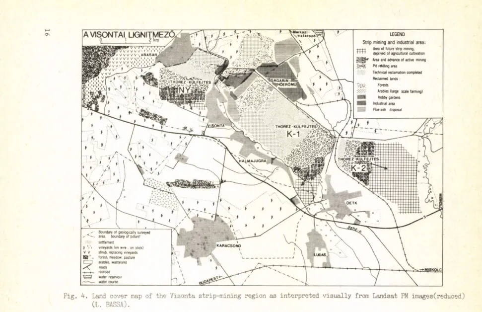
VISUAL INTERPRETATION: A LAND COVER MAP
The higher resolution of Landsat TM images and the progress of colour composite techniques both have contributed to a more exact inter
pretation of the land cover categories concerned. An experiment using colour composites obtained from Landsat TM images of 19.05.1984 (late spring), 04.04.1985 (early spring) and 20.09.1985 (autumn) resulted in the compilation of a map on the basis of multitemporal interpretation (Fig. 4). This mapping primarily aimed at the identification of land cover categories on areas disturbed by strip mining and also on undisturbed surfaces. Ancillary materials: aerial photos at 1:10, 000 and 1:1, 000 were also involved in the interpretation,
a/ Areas of active mining and refilling
Prior to mining the agricultural utilization of the land was aban
doned as shown by fading tones for arable. Overburden is removed by drag-lines, shovels and scrapers. After the coal seam is exposed it is loaded and transported by production lines (clearly discernible on images in the West unit area) to the nearby power plant . This information on mining methods functions as a priori information, essential for interpretation. Procedures of removal and extraction create long linear pits which can be detected on space images as dark stripes on the back
ground of the surrounding areas of higher reflectance where overburden is to be removed or pit refilling after extraction is already started.
Reflectance depends on the mechanical composition of bedrock and its hyd-
15
LEGEND
Strip mining and industrial area:
T -f-t-t Area o f fu ture strip mining, ' ' ' ' deprived o f agricu ltura l cultiva tion
Area and advance o f active m in ing Pit refillin g area
Technical reclam ation completed Reclaimed la n d s :
Forests
Arables (large scale farm ing) Hobby gardens
W M Industria l area Flue-ash disposal
Fig. 4. Land cover map of the Visonta strip-mining region as interpreted visually from Landsat PM images(reduced) (L. BASSA).
rophysical properties. On each of the three images studied these differen
ces are discernible. In pit West (NY) overburden is represented by Upper Pannonian yellow and greyish-yellow sandy deposits which also occur on surface after refilling. Moving eastwards the material of internal refuse dumps gradually becomes loamy as indicated by darker tones. The properties of the surface layers play a decisive role in subsequent agricultural cultivation. It is desirable that upper horizons be shaped using materials of yellow sandy loam mixed with fossil soils encountered in the upper 10 metre sequence. The water holding capacity of these layers in higher but they are less cultivable owing to heavier texture. Refilled areas (i.e.
where technical reclamation is completed) show a more or less homogeneous texture.
b/ Reclaimed lands
On 600 hectares (1/5 part of the total area disturbed by strip mining and industry) biological reclamation has already been accomplished. A 'reference area' on the external spoils (NE from the West (NY) unit) experi
enced the complex fast revegetation without topsoiling, introduced from 1969. After the spoil heap had been shaped (grading and levelling), its surface layer was improved by fertilizers and low-grade lignite powder vegetation (nurse'crop) with extensive root system developed which subse
quently was ploughed in, thus promoting soil formation. From the second year different crop species were grown and good results reported (OLÁH, J.
1983). Graded slopes have been afforested. Three large fields of this type have been created by now as it is shown on the late spring image but bare soil surfaces (early spring and autumn pictures) reveal substantial inhomo
geneities. Also the hobby garden area (NW part of the East N1 (K-l) unit) shows differences in the mechanical composition of surface and vegetation cover. When communicating with local farmers they mentioned their pains
taking work in clearing the surface from stones. Flue ash disposals (dark blue patches) have partly been filled and afforested but some of them still exist exerting a strong adverse impact on the environment,
c/ Areas of further expansion of mining
As the mining is extending southwards and eastwards (Fig. 4), more fer
tile soils are affected by excavations (categories with 40-49 soil value number vs the former 30-39 according to the 100-point assessment system in force). The West (NY) pit advances at the expence of vineyards; East N1 (K-l) has already moved close to the N° 3 main road and the southern part
17
■ G e o m o r p h o I o q i ca I
of which will affect arable lands and vineyards, and there is a large derelict land stretching east of the East N2 (K-2) pit. An economic assessment on the productive potential of these lands and reclamation planning is considered to be an urgent task.
D IG IT A L IMAGE PRO C ESSIN G : A C L A S S IF IC A T IO N MAP
In the course of the study of the strip mining area one of the images involved in visual interpretation (19.05.1984) was processed. A super
vised classification was carried out on the PERIC0L0R 2000E image proces
sing device i-n the Institute of Geodesy, Cartography and Remote Sensing using Remote Sensing Package. Based on sources from literature in classi
fication initially were included spectral regions TM1, TM2, TM3 (visible wavelengths), TM4 (near IR) and TM5 (medium IR).
The digital plotter image covers an area of 9 km x 12 km and contains 300x400 pixels. Training sites were chosen using the ground truth (refe
rence) data as shown on the map (Fig. 4) obtained by visual interpreta
tion and field survey. The 12 lands cover categories occurring in the region were identified and used for training: active mining, refilling area, technical 'reclamation' completed, reclaimed land, industrial area, flue-ash disposal, settlement, vineyard, forest, grassland, arable land, water surface. During training statistics referring to the sites identi
fied: pixel number, average density and the band covariance matrix of the pixel intensities were applied.
After the analysis spectral bands TM1 and TM2 were left out and processing was accomplished using the three, most informative bands:
TM3 (red) TM4 (near infrared) and TM5 (medium infrared).
Classification was carried out by minimum distance decision rule.
For each main point x and each average vector x^ (j=l,..,m) a decision function
g^(x) = i=2,n xt - x ^ j=l,..,m
is computed and x classified by the minimum of this function.
The resulting 12 classes are not entirely identical with those of the training sites. This is primarily attributed to the fact that while the training sites show broad comprehensive categories (for example 18
settlements), on the plotter image pixels with identical spectral fea
tures are grouped together (within settlements, reflectance varies with gardens, paved surfaces or roofs of houses).
The classification map was produced by OPTRONICS Colormatian 4500 plotter.
A P O S S IB L E FUTURE A P P L IC A T IO N : THE BÜKKÁBRÁNY S T R IP M IN IN G AREA
The location of a new strip mining area on the southern foothills of the Bükk mountains (Northern Hungary) is shown on Fig. 5. The extrac
tion of lignite has recently started and annual output amounts to 1,5 Mt. Somewhat similar in environmental impact to its counterpart at Visonta (appearance of derelict lands and necessity of their reclamation, changes in hydrogeological conditions and surface water configuration, air pollution and noise) this area also needs monitoring and this task may partially be fulfilled by remote sensing. A Landsat TM colour compo
site was obtained fixing the initial stage of surface mining (08.07.
1587) (KISGYÖRGY, S. - MADAI, L. 1987)
SUMMARY
Multitemporal, multi-level and multispectral remotely sensed images can provide useful information to the monitoring of man-induced environ
mental changes in general and of implementation of reclamation projects in particular.
The achievements reported here represent only a modest contribution to the solution of a major problem of landscape reconstruction in strip mining regions of Hungary: which is the most effective way of land reclamation from economic and environmental viewpoints:
1/ Technical 'reclamation' (exclusively), accompanied by financing of amelioration in other areas of the country to counterbalance loss of fertile lands in the strip mining regions,
2/ Complex fast revegetation method ('reference area', Visonta),
3/ Optimization of surface layers (how to achieve loose, friable and loamy structure without topsoiling),
19
Fig. 5- Allocation plan of the Bükkábrány open— pit mine and power plant (after Gy. HAHN, Gy. OSWALD and L. SÁG). - 1= present railway to be relocated; 2= planned new railway alignment; P= power plant; S=
spoil-heap; A, B, C = open-pit mines
4/ Spreading of the stockpiled topsoil upon the surface (a stringent rule of reclamation in several countries).
ACKNOWLEDGEMENTS TO
Or. MÁRIA DOMOKOS (Budapest Technical University), who let authors use Landsat MSS colour composites and a Landsat TM5 Image),
LÁSZLÓ KISS (ERŐTERV, Budapest) for providing a panchromatic photo at 1:10 000 scale, colour and colour IR photos at 1:1 000 scale, Dr. DÉNES LÖCZY for reading the English text.
20
REFERENCES
HAHN, GY. - OSWALD, GY. - SÄG, L. 1985- The economic geological importance of the lignite at the foreland of the Northern Hungarian Uplands. - In: Problems of the Neogene and Quaternary (Eds. by M. KRETZOI and M.
PÉCSI). Akadémiai Kiadd, Budapest pp. 115-128.
HALÁSZ, T. 1983- The landscape reservation tasks of environment of above ground coal mines through an example of landscape recultivation plan of
"Thorez" mining area. - In: Recultivation of technogenous areas (Ed. by J. SZEGI). Mátraalja Coal Mining Company, Gyöngyös, pp. 69-79- KISGYÖRGY, S. - MADAI, L. 1987. A bükkábrányi 1,5 M t/a kapacitású külfej
tés környezeti hatásai (Environmental effects of Bükkábrány open-cast mine of 1,5 M t/year capacity - in Hungarian). Bány. Koh. L. - Bány.
120 (Spec. Issue 1): K 57-K 62
National Research Council 1981. Surface Mining: soil, coal and society. - Natl, Acad. Press. Washington. 233 p.
OLÁH, J. 1983. The evaluation of the long-term effects of fast complex re
cultivation in the light of crop results and economic aspects. In:
Recultivation of technogenous areas (Ed.by J. SZEGI). Mátraalja Coal Mining Company, Gyöngyös, pp. 51-59-
TÓTH, S. 1983- Major economic problems in agricultural recultivation after open cut mining. - In: Recultivation of technogenous areas (Ed. by J.
SZEGI). Mátraalja Coal Mining Company, Györgyös, pp. 61-68.
TOY, T. J. 1984. Geomorphology of Surface-Mined Lands in the Western United States - In: Developments and Applications in Geomorphology (Ed. by J.
E. COSTA and P. J. FLEISHER). Springer Verlag, Berlin-Heidelberg, pp.
133-170.
Address of authors:
János Balogh, László Bassa, György Hahn and Árpád Ringer Geographical Research Institute
Hungarian Academy of Sciences H-1388 Budapest, P.O.Box 54.
Éva Csaté
Institute of Geodesy, Cartography and Remote Sensing H-1443 Budapest P.O.Box 132.
Zoltán Gerencsér
Vörös Csillag Cooperative Farm H-9766 Rum, Szabadság tér 2.
21
G e o m o r p h o l o g i c a l a n d G e o e c o l o g i c a l E s s a y s S t u d i e s in G e o g r a p h y in H un gary, 25
A k a d é m i a i Kiadó B u d a p e s t , 1989
I N V E S T I G A T I O N O F P I P E F L O W ON A L O E S S - C O V E R E D S L O P E
A . K E R É N Y I
ABSTRACT
The task of preventing erosion on loess-covered sloping surfaces requires a lot of careful planning of experts working in the field of mechanical soil conservation. To prove this statement measurements have been carried out on a system of terraces established on a loess-covered slope. The ter
races were built 25 years ago and are of counterslope character. A few years later the process of pipeflow started on the lowest-lying planes of the terraces. Loess wells, pipeflow ducts, cave-ins were produced, which made part of flip terraces unsuitable for cultivation. The loss of soil amounted to 476 nv/ha in the most heavily degraded areas.
For the better understanding of the mechanism of the process of pipe- flow laboratory experiments and measurements were carried out. The study was concerned with dissolution processes taking place in soil-covered and uncovered loesses. It was established that the dissolving effect of water is more efficient in soil covered loess. It was demonstrated that pipeflow starts quickly on counterslope terraces due to the emergence of excess water. The primary factor in the start of the process is the dissolving effect of water. Our experiments provided quantitative data on the inten
sity of the dissolving process. On the grounds of the investigations we made suggestions how the shape of terraces to be established in loess ar Gas.
23
P R E V IO U S IN V E S T IG A T IO N S
One of the main tasks of Hungarian loess research is the elucidation of the genetics and chronology of our homeland loesses. In this field a number of internationally outstanding results have been published by Hun
garian authors: M. PÉCSI (1965, 1966, 1975, 1979); M. PÉCSI - M.A. PEVZNER (1974); M. PÉCSI - É.PÉCSI-DONÁTH et al. (1977); GY. HAHN (1977); Z. BORSY - 0. FÉLSZERFALVI - P.P. SZABÓ (1979); Z. BORSY - J. FÉLSZERFALVI- 0. LÓKI (1984); Z. PINCZÉS (1954); 3. SZILARD (1983).
The other line of the investigations is represented by the mapping of the forms of loess degradation and the detailed characterization and gene- tical description of these forms. In this field mention must be made of the works of L. ÁDÁM (1954, .1964); L. ÁDÁM - S. MAROSI - J. SZILÁRD (1959) and L. ZÁMBÓ's (1971) maps of erosional gullies.
The quantitative study of the intensity of loess degradation is the characteristic feature of the third aspect of the investigations. Field measurements and, on the basis of these, calculations were performed by L. ÁDÁM in 1964. Attention must be called to the field experiments and measurements by Z. PINCZÉS (1968, 1980) and Z. PINCZÉS-L. BOROS (1967).
The direct antecedents of the present investigations are the field and laboratory experiments by A. KERÉNYI (1984). In this paper we served to solve the following problems: What ions and in what quantity are trans
ferred into solution by water seeping through or running off the surface of loess? Further examination was performed to clear up the effects of the various ways of treatment on the dissolving power of water.
RESULTS
Measurements have been carried out in the worldfamous Tokaj viticultural region on a terrace system extablished on a loess-covered slope. In a certain section the terraces are countersloping thus, in a rainy weather and in the periods of snow melting thaw pools developed at the deepest points (Fig. 1.). Three to five years later the first pipeflow
24
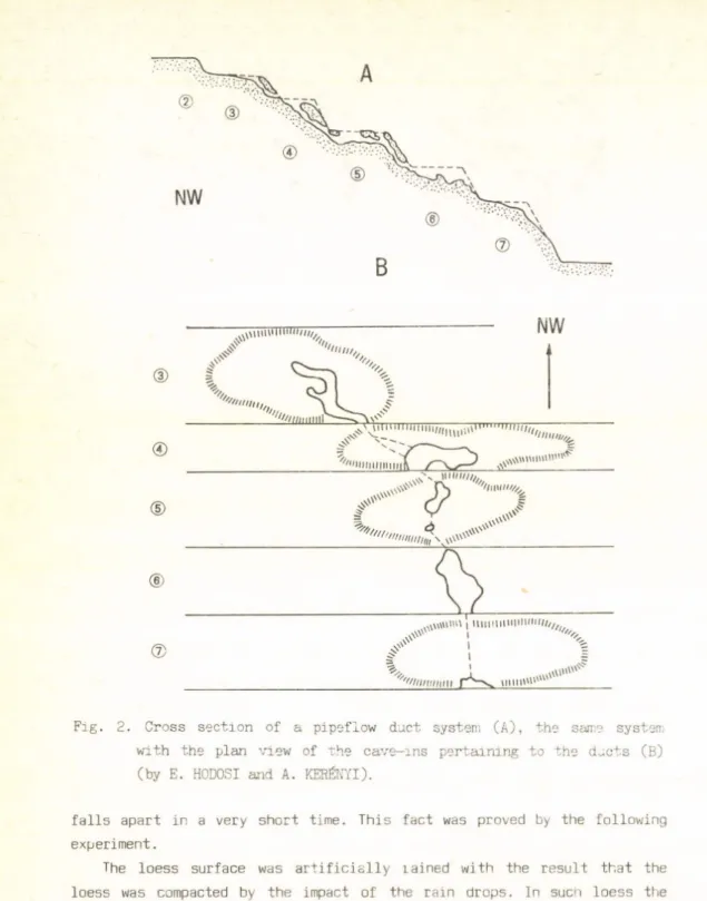
Pig. 1. A section of the terrace system under study (by A. KERÉNYI). - A= Immediately after its construction; B= After 25 years; P= pool formation. The arrows denote the main directions of runoff, the broken line shows the potential sites of pipeflow ducts and cave, -ins
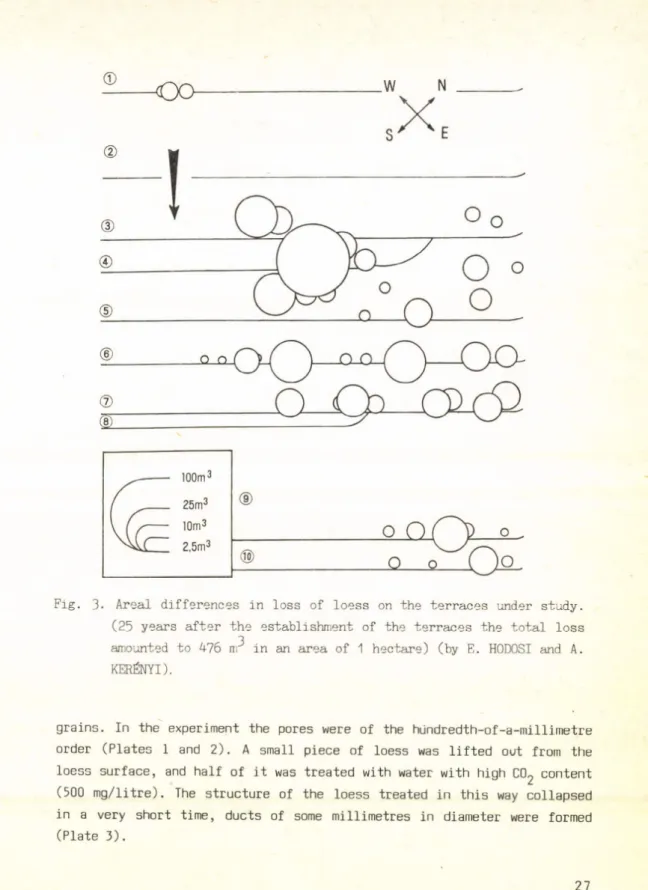
ducts appeared which, in the course of the subsequent 25 years, were transformed into a large pipeflow system (Fig.2). In the area of the ducts cave-ins (loess sink holes) and loess wells evolved, the ducts constitu
ting the system of caves fell in at places and were formed into erosional ditches. Vine cultivation had to be abendoned in this area. The loss of loess was determined - on the grounds of accurate field surveys - with volumetric calculations (476 m^) and its areal distribution was represen
ted on a cartogram (Fig.3).
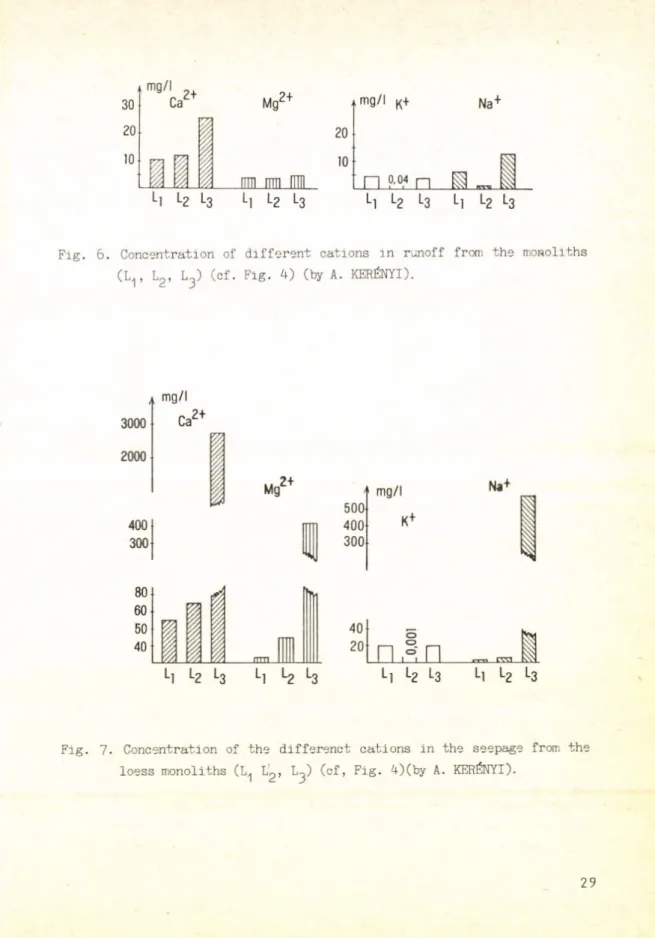
To study the process of loess degradation, concomitantly with the field survey laboratory examinations were carried out on loess monoliths with original structure (Figs. 4 and 5). The rainfall simulator ope
rated with distilled water, and the concentration of various ions was determined in the runoff from the surface of the loess monoliths,then in the water seeping through them (Figs. 6, 7 and 8). It was established that in the water seeping through the loess the amount of dissolved ions was, on an average, five-fold of that in surface runoff. Under these circumstances a considerable role is played by the higher CC^ content of the air in the soil and the duration of seepage. When exposed to the dissolving effect of water with high CC^ content, the structure of loess
25
4 G e o m o r D h o I oá i ca I
Fig. 2. Cross section of a pipeflow duct system (A), the same system with the plan view of the cave-ins pertaining to the ducts (B)
(by E. HODOSI and A. KERÉNYI).
falls apart in a very short time. This fact was proved by the following experiment.
The loess surface was artificially íained with the result that the loess was compacted by the impact of the rain drops. In such loess the po.?e size is primarily determined oy the grain size and shape of the loess
26
©
O o _W N
-X.
Fig. 3. Areal differences in loss of loess on the terraces under study.
(25 years after the establishment of the terraces the total loss amounted to 475 n? in an area of 1 hectare) (by E. HODOSI and A.
KERÉNYI).
grains. In the experiment the pores were of the hiindredth-of-a-millimetre order (Plates 1 and 2). A small piece of loess was lifted out from the loess surface, and half of it was treated with water with high C02 content (500 mg/litre). Ihe structure of the loess treated in this way collapsed in a very short time, ducts of some millimetres in diameter were formed (Plate 3).
27
© © Li
Fi 4. Place of origin of the loess samples of original structure (monoliths) (by A. KERÉNYI).
1. L ^ f r o m the ploughed layer of the terrace (A ) I^-from the bank of the terrace
2. L^= loess monolith taken from the wall of the deep-cut track.
The arrows show the direction of the current of soil solutions, the dotted area denotes the layer rich in precipitated salts
RS
u °" I Tu U u u u n r
0 0
0
oo
0
0 p 0 0
0
•
o 0 F ° 0
Fig. 5. Experiment on a loess monolith. RS= rainfall simulator, P= arti
ficial rain (distilled water) (by A. KERÉNYI).
= loess monolith; F = metal frame; RO = pipe for draining runoff; V = plastic vessel to collect seepage water
28
Fig. 6. Concentration of different cations in runoff from the monoliths (Lr L2 , L 3 ) (cf. Fig. 4) (by A. KERÉNYI).
3000 2000
m g /l
Ca2+
400
1
300
m g /l 500 400 300
Na+
Fig. 7- Concentration of the differenct cations in the seepage from the loess monoliths (L^ L^) (cf, Fig. 4 ) (by A. KERÉNYI).
29
m g /l 7000 ci-
6000 5000
2-
co
3Fig. 8. Concentration of carbonate, chloride and sulphate ions in the seepage from the loess monoliths (cf. Fig. 4)(by A. KERÉNYI).
In the first stage of loess degradation dissolution is predominant - ex
cept when the formation of ducts has been initiated by human mechanical interference. It was observed for instance that the holes along the vine- stakes driven deep into the ground gave rise to mechanical pipeflow (Plate 4).
In another experiment it was proved that the dissolving effect of the water flowing in a duct of 2-3 cm in diameter decreases as compared to the same effect of water moving in pores of tenth-of-a-millimetre or smaller size, and it becomes similar to the effect of runoff. In ducts of such and larger sizes the mechanical decay becomes prevalent.
As for the ions, the relatively high concentration of potassium in the seepage from L-^ (Figs. 6 and 7) can be attributed to artificial fertilizers. Ihe presence of artificial fertilizers can be ruled out in L^. In the wall of the loess deep-cut track, due to the horizontal capil
lary tension gradient, salty solutions are seeping horizontally, and get 30
Plate 1. Loess grains on the surface of a monolith after artificial raining. M = 200 x
’late 2. Loess grains on the surface of a monolith, in a spatial arrange
ment different from the previous one (cf. Plate 1). M = 200 x 31
Plate 3- Ducts of the order of millimetres, evolved as a result of acidic dissolution in loess. Above: original, artificially rained loess surface. M = 10 x
precipitated in the surface layer (Fig. 4). In the course of centuries this layer was primarily enriched in chlorides, however, the amount of sulphates is also considerable in addition to carbonates always present in large quantities in loess. The chlorides are readily soluble, thus in the seepage from the monolith the chloride concentration has reached an extreme level (Fig. 8). The material of the wall of the loess deep-cut track displays lower mechanical resistance than that of the walls of the pipeflow ducts, thus the physico-chemical changes described here accelerate the mechanical degradation. This process is still at an initial 32
Plate 4. In the lower-lying areas of the terrace pipeflow ducts have evolved along the vinestakes driven deep into the ground. Tokaj, Rákóczi Valley
stage on the terraces in the walls of the caved-in pipeflow ducts trans
formed into erosional ditches.
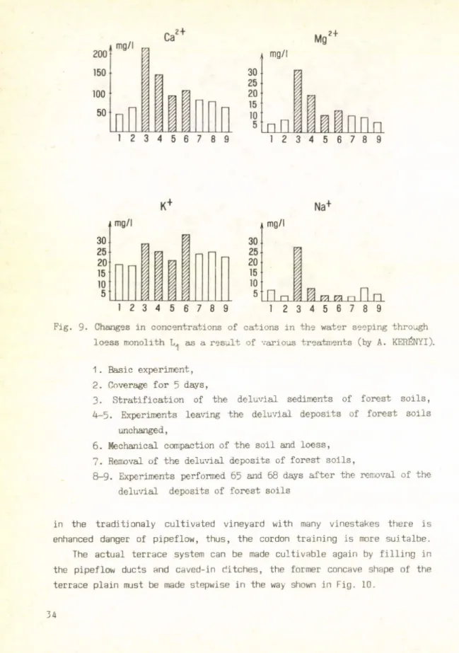
Further examinations were performed to clear up the effects of the various ways of treatment on the dissolving power of water (Fig. 9). It has been established that the dissolving action was most enhanced by a 3 cm thick soil layer (pH= 6.8: CaC0^=0 h, humus= 1,6 %) spread over the loess monolith. This also proves that on soilcovered loess, in the estab
lishment of the terraces special care must be taken of the water economy of the soil. Pool formation must be avoided on terraces built on loess.
For this reason the terraces must not be countersloping, the downward sloping of 1-2° is the most recommendable. In view of our observations,
33
5 G e o m o r o h o I o q i ca I
200 150
Ca2+ Mg2 +
m g /l 30 25-
20
15
10
5
L
nil I I
1 2 3 4 5 6 7 8 9
K+ Na+
Fig. 9- Changes in concentrations of cations in the water seeping through loess monolith as a result of various treatments (by A. KERÉNYI).
1. Basic experiment, 2. Coverage for 5 days,
3. Stratification of the deluvial sediments of forest soils, 4-5. Experiments leaving the deluvial deposits of forest soils
unchanged,
6. Mechanical compaction of the soil and loess, 7. Removal of the deluvial deposits of forest soils,
8—9- Experiments performed 65 and 68 days after the removal of the deluvial deposits of forest soils
in the traditionaly cultivated vineyard with many vinestakes there is enhanced danger of pipeflow, thus, the cordon training is more suitalbe.
The actual terrace system can be made cultivable again by filling in the pipeflow ducts and caved-in ditches, the former concave shape of the terrace plain must be made stepwise in the way shown in Fig. 10.
34
NW SE
---- 1
---2
Fig. 10. Transformation of the terrace plane results in the evolution of small water-collecting pools and prevents the gathering of excess water along the bottom-line of the terrace plane (broken lin e ) . The thin line shows the present-day position of the terrace plane (no pipeflow ducts are show n ) , the thick line is the proposed stepped plane of the terrace. On the left the sloping of the terrace plane is given in degrees (by E. H0D0SI and A. KERÉNYI).
REFERENCES
ÁDÁM L. 1954. A mezőföldi löszös területek karsztos formáiról. - Földr.
Köziem. 2 (4): 339-350.
ÁDÁM L. 1964. A Szekszárdi-dombvidék kialakulása és morfológiája. - Akadé
miai Kiadó, Budapest, 83 p.
ÁDÁM L. - MAROSI S. - SZILÁRD J. (ed.) 1959. A Mezőföld természeti föld
rajza. - Földrajzi monográfiák 2. Akadémiai Kiadó, Budapest, 514 p.
ANDERSON, M. - BURT, T.P. 1982. Throughflow and pipe monitoring in the humid temperate environment. - In: Badland Geomorphology and Piping, ed. Bryan R. and Yair A., University Press, Cambridge, PP. 337-354.
BORSY, Z. - FÉLSZERFALVI, J. - SZABÓ, P.P. 1979. Thermo luminescence dating of several layers of the loess sequences at Paks and Mende (Hunga
ry). - Acta Geol. Hung. 22 (1-4): 451-459.
BORSY, Z. FÉLSZERFALVI, J. - LÖKI, J. 1984. Electronmicroscopic inves
tigation of the sand material from the loess exposure at Paks. In:
M. PÉCSI (ed.) Lithology and Stratigraphy of Loess and Paleosols.
Geogr. Res. Inst., Budapest, pp. 71-86.
35
CHODAK, T. — KOWALINSKI, S. 1972. Microrr.orphological and mineralogical properties of some soil types developed from loess. Panstwowe Wydaw- nictwo Naukowe, Warszawa, pp. 219-231-
CSORBA, P. 1985- Tokaji löszön kialakult talajok és földes kopárok nedves
ségviszonyainak tér- és időbeli változása. - Földr. Ért. 34 (3):
283-297.
DERBYSHIRE, É. 1984. Granulometry and fabric of the loess at Jiuzhoutai, Lanzhou, People's Republic of China. - In: M. PÉCSI: Lithology and Stratigraphy of Loess and Paleosols, Budapest, pp. 95-103- DREW, D.P. 1982. Piping in the Big Muddy badlands, Southern Saskatchewan,
A. -University Press, Cambridge, pp. 293-304.
HÁHN, GY. 1977. A magyarországi löszök litológiája, genetikája, geomor
fológiai és kronológiai tagolása. - Földr. Ért. 26 (1): 1-28.
HARVEY, A. 1982. The rolé of piping in the development of badlands and gully systems in South-East Spain. - In: Badland Geomorphology and Piping, ed. Bryan R. and Yair A., University Press, Cambridge, pp.
317-335.
JAMAGNE, M. 1972. Some micromorphological aspects of soils developed in loess deposits of Northern France. Panstwowe Wydawnictwo Naukowe, Warszawa, pp. 559-582.
JAKUCS, L. 1977. Morphogenetics of Karst Regions (Variants of Karst Evo
lution) - Akadémiai Kiadó, Budapest, 263 p.
JAKUCS, L. 1980. A karszt biológiai produktum. - Földr. Köziem. 28 (4):
331-342.
JONES, J.A.A. 1982. Experimental studies of pipe hidrology. - In: Badland Geomorphology and Piping, ed. Bryan R. and Yair A. University Press, Cambridge, pp. 355-370.
KERÉNYI, A. 1984. A talajerózió vizsgálatának laboratóriumi kísérleti módszere - Földr. Ért. 33 (3): 266-276.
KRIGER, N.I.-PÉCSI, M. 1987.Engineering geological research of loess and loess-like sediments in the USSR. Loess inform 1. Budapest, 144 p.
PÉCSI, M. 1965. The loe sses and types of loess-like sediments of the Carpathian Basin and their lithostratigraphical classification. - Földr. Köziem. 13 (4): 305-338.
PÉCSI, M. 1975. A magyarországi löszszelvények litosztratigráfiai tagolá
sa. (Lithostratigraphical subdivision of the loess sequences in Hungary.) Földr. Köziem. 23 (3-4): 217-223.
36
PÉCSI, M. 1979. Lithostratigraphícal subdivision of the loess profiles at Paks. - Acta Geol. Hung. 22 (1-4): 409-418.
PÉCSI, M. - PEVZNER, M. 1974. Paleomagnetic measurements in the loess sequences at Paks and Dunaföldvár, Hungary. - Földr. Köziem. 22 (3) : 215-226.
PÉCSI, M. - SZEBÉNYI, E. 1971. Guide book for Loess Symposium in Hungary.
IGU European Regional Conference, Budapest, 34 p.
PÉCSI, M. - PÉCSI-DONÁTH, É. - SZEBÉNYI, E. - HAHN, GY. - SCHWEITZER, F. - PEVZNER, M.A. 1977- Paleogeographical reconstruction of fossil soils in Hungarian Loess. - Földr. Köziem. 25 (1-3): -94-134.
PINCZÉS, Z. 1954. A tokaji Nagy-hegy lösztakarója. - Földr. Ért. 3 (3):
575-584.
PINCZÉS, Z . 1968. Vonalas erózió a Tokaji-hegy löszén. - Földr. Köziem.
16 (2): 159-171.
PINCZÉS, Z . 1980. A művelési ágak és módok hatása a talajerózióra. - Földr. Köziem. 28 (4): 357-379.
PINCZÉS, Z. - BOROS, L. 1967. Eróziós vizsgálatok a Tokaji hegy szőlőterü
letein. - Acta Geographica Debrecina 5-6: 308-325 (1966-1967).
PYE, K. 1984. SEM investigations of quartz silt microtextures in relation to the source of loess. - In: M. PÉCSI (ed.) Lithology and Stra
tigraphy of Loess and Paleosols. - geogr. Res. Inst. Budapest, pp.
139-152.
SAJGALIK, I. 1979. Dependence of microstructure of loesses on their gene
sis - Acta Geol. Hung. 22 (1-4): 255-266.
SZILÁRD, J. 1983- Dunántúli és Duna-Tisza-közi löszfeltárások új szempontú litológiai értékelése és tipizálása. - Földr. Ért. 32 (1): 109-166.
ZÁMBÓ, L. 1971. Study of some development factors of anthropogen!cally preformed loess gullies. - Acta Geographica Debrecina 10: 113-116.
Address of author:
Attila Kerényi
Kossuth Lajos University
H-4010 Debrecen, Egyetem t é r 1.
37
G e o m o r p h o l o g i c a l a n d G e o e c o l o g i c a l Es s a y s S t u d i e s in G e o g r a p h y in H u n g a r y , 25
A k a d é m i a i K ia dó B u d a p e s t , 1989
G E N E T I C S A N D O C C U R R E N C E O F H O L O C E N E T R A V E R T I N E S I N H U N G A R Y
G Y . S C H E U E R - F . S C H W E I T Z E R
ABSTRACT
There are several known travertine occurrences in Hungary connected either partly or fully to karst mountains or to only parts of them. A greater part originates from Pliocene or Pleistocene according to geo- morphological and paleo-karsthydrogeological examinations. Beside these older ones Holocene accumulations are also quite common and at many places there are travertines being formed recently.
Their accumulation in the mountains and in their surroundings can be explained by the precipitation of calcium carbonate transported by the springs.
In the course of surveying the Hungarian travertines there was a possibility to examine the accumulations on these mountainous territories.
We examined their occurrences and genetics and tried to define their types (Fig. 1. and 2.).
Among the examined Holocene travertines some have very spectacular forms, because of continuous precipitation (Szalajka, Lillafüred). These occurrences are officially protected. Their preservation and the continuity of lime-depositing in guaranteed. The observations are important because the process of travertine sedimentation can be examined directly at the site and the recognition of forms under development can help to explain the advantages properly. That is why we thought, that the study of Holocene and recent travertines is essential.
39
Fig. 1. Schematic layout of the karst hydrogeological regional units (after Gy. SCHEUER - F. SCHWEITZER). - 1= Villány Mts.; 2= Mecsek Mts.; 3=
Transdanubian M t s .; 4= Bükk M t s .; 5= Aggtelek region and Szendrő Mts. The shaded part shows the extension of carbonate rocks
TYPES QF HOLOCENE TR A VERTIN ES AND THE C L IM A T IC C O N D ITIO N S FORMING THEM
In the course of the examination of Hungarian and foreign recent travertines we can state that the accumulation of lime is connected to springs differring from each other from the point of view of origin and type (Fig. 3.).
The springs depositing carbonate spring-deposits can be divided into 4 groups:
a/ cold-water karst-springs and water-courses of karstic origin b/ karstic thermal springs and their waters
c/ ground-water, lithoclase springs
d/ springs of polygenetic origin (springs of post-volcanic areas)
40
Fig. 2. Various types of freshwater limestone (after Gy. SCHEUER — F.
SCHWEITZER). A= valley type; B= valleyside type; C= palustrine and paludal type; D= sinter cone type.
L e g e n d : 1= Freshwater limestone; 2= Lakes due to streamwater dairming by tetarata accumulations; 3= Underlying rock; 4= Water
bearing carbonate rocks; 5= Impervious strata; 6= Fluviatile or slope sediments; 7= Karst spring; =A= Spring-lake; 8= Spring vent;
9= Spring crater
Any of the above mentioned springs are able to accumulate travertines in their vicinity under favourable environmental conditions.
Examining the Hungarian sites and comparing them to the former ones we can state that most of the Hungarian Holocene travertines originate from springwaters belonging to group a/.
We have collected and processed the data of those karstic springs
41
6 GeomorphoIogi ca I
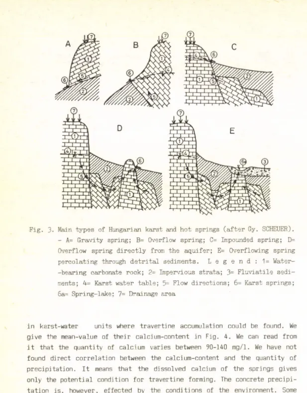
Fig. 3. Main types of Hungarian karst and hot springs (after Gy. SCHEUER).
- A= Gravity spring; B= Overflow spring; C= Impounded spring; D=
Overflow spring directly from the aquifer; E= Overflowing spring percolating through detrital sediments. L e g e n d : 1= Water- -bearing carbonate rock; 2= Impervious strata; 3= Fluviatile sedi
ments; 4= Karst water table; 5= Flow directions; 6= Karst springs;
6a= Spring-lake; 7= Drainage area
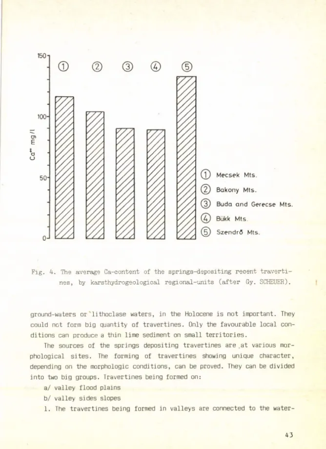
in karst-water units where travertine accumulation could be found. We give the mean-value of their calcium-content in Fig. 4. We can read from it that the quantity of calcium varies between 90-140 mg/1. We have not found direct correlation between the calcium-content and the quantity of precipitation. It means that the dissolved calcium of the springs gives only the potential condition for travertine forming. The concrete precipi
tation is, however, effected by the conditions of the environment. Some karstic thermal springs (group b) have also originated travertines. In Hungary the ability of depositing calcium of springs, coming from
42
©
©
©
©
©
M e c s e k M ts . B a k o n y M ts .
B u d a a n d G e re c s e M ts . Bükk M ts .
S z e n d r ő M ts .
Fig. 4. The average Ca-content of the springs-depositing recent traverti
nes, by karsthydrogeological regional-units (after Gy. SCHEUER).
ground-waters or lithoclase waters, in the Holocene is not important. They could not form big quantity of travertines. Only the favourable local con
ditions can produce a thin lime sediment on small territories.
The sources of the springs depositing travertines are .at various mor
phological sites. The forming of travertines showing unique character, depending on the morphologic conditions, can be proved. They can be divided into two big groups. Travertines being formed on:
a/ valley flood plains b/ valley sides slopes
1. The travertines being formed in valleys are connected to the water-
43
courses of karstic mountains. One can see such depositions in the beds of water-courses that hinder them. At such places smaller or greater water
falls are formed. This type is very frequent in Hungary and can be found in almost all karstic mountains. We have described it as a valley-type rock. The largest and most beautiful (spectacular) accumulations (Szalajka waterfalls and Lillafüred in the Bükk Mts.) belong into this group.
The springs of valley-flood plains are quite common in Hungary, where spring-lakes or swamps have been formed. In these cases lake-type limes
tones were formed. The most important occurrence can be found at Tata in the Gerecse Mts. and at Római-fürdő in Budapest (Fig. 5.).
2. Most of the travertines were formed on various slopes. Such depo
sitions were formed by springs on the slopes under it, having their source above the erosion base. Such formations (tetaratas) and structures are characteristic only for these types (Fig. 6.).
The deposition of travertines depends on the lime-capacity of the springs and on the morphologic conditions of the slope. At some places it covers a 1-5 metres wide territory of the slopes and the travertines accu
mulate in the form of a fan. Its characteristic forms are the tetarata bars and pools (Fig. 2.A.).
In Hungary these tetarata limes, coming from springs above erosion base on slopes, are quite frequent.
THE EFFECT OF HOLOCENE C L IM A T IC FLU C TU A TIO N S ON THE FORMATION OF TR A V E R T IN E S
Travertines could be formed any time, when the necessary conditions and advantages were given (precipitation, vegetation).
So the limestones reflect the environmental conditions of the era of their formation. We can trace back the age of deposition and of the climatic conditions of their formation from the imprints of plants and the fauna, from the loose sediments (like loess, sandy loess, sand, fossil soils) which have been formed during various climatic conditions, or from the cryoturbational phenomena and archeological finds, too and from the data concerning the age of geologic formations and geomorphologic levels on which all these were deposited. From the evaluation of the results from the joint examinations we can get information about the age of travertine- formations (Fig. 7.).
4 4
0 100 m
1 - - - 1
Fig. 5. Flood-plain-lacustrine-marshy travertine formation associated with spring issuing from covered hörst through fluvial sediments (after F. SCHWEITZER). - 1= permeable Triassic sediments; 2= impermeable Tertiary sediments; 3= recent sediments of the Áltál-ér; 4= traver
tine
Fig. 6. Terrace springs of Tata and the geomorphological position of the travertine (after F. SCHWEITZER). - 1= spring lake and spring crater; 2a= recent sediment of the Által-ér; 2b= younger terraces of the Által-ér; 3= impermeable Tertiary rocks; 4= permeable Triassic rocks; 5= travertine, direction of water flow
45
Fig. 7. A fragment of the travertine profile at Mónosbél (after Gy.
SCHEUER - F. SCHWEITZER) .1= slope travertine; 2= deluvial olay with Triassic rook fragments; 3= charcoal-bearing horizon; 4= hydro- morphic soil; 5= lime mud
CONCLUSIONS
The examination of travertines proves that there was an interruption in the activity of the springs forming them, or their ability to deposit lime has greatly decreased. This can be explained by such climatic condi
tions, which were not favourable for it.
Most of the Holocene travertines were settled on young relief-forms (like valley-floors). Where they are lying on older relief-forms there is a spring activity and travertine-accumulation at present, too. From this we can deduct their age.
There have been several climatic conditions within the Holocene period, which were not all favourable for the formation of travertines e.g. the Boreal phase had a warm continental climate. There was not enough preci
pitation, the infiltration decreased, so the springs had a smaller delivery.
The soil covering of the karst had a restricted biological activity, so there was less lime in the springs, too. Therefore the accumulational 46
activity decreased or stopped. This unfavourable period was followed by the next Oak (Atlantic) period, with a duration of 2500-500 years; it had a submediterranean climate and was very favourable for the formation of travertines. We can say that this was the culmination of this process. Of course it continued later on and it is still continuing, but with a less intensity.
REFERENCES
BÖGLI, A. 1978. Karsthydrographie und physische Speläologie. - Springer Verlag, Berlin-New-York.
CHOLNOKY, J. 1940. A mésztufa vagy travertinó képződéséről (On the forma
tion of calcareous tuff or travertine). - Mat. Term. Tud. Ért. 59:
1004-1010.
JAKUCS, L. 1977. Morphogenetlcs of karst regions - Akadémiai Kiadó, Budapest. 279 p.
JAKUCS, L. I98O. A karszt biológiai produktum (Karst is a biological product) - Földr. Közien-.. 28 : 331-334.
HEVESI, A. 1972. Forrásmészkő képződés a Blikkben. (Formation du travertine dans la Montagne de Blikk) - Földr. Ért. 21: 187-205.
PÉCSI, M. 1959. A magyarországi Duna-völgy kialakulása és felszínalaktana (Entwicklung und Morphologie des Donautales in Ungarn). - Földrajzi Monográfiák III. - Akadémiai Kiadó, Budapest. 346 p.
SCHEUER, GY. - SCHWEITZER, F. 1974. Adatok a Balaton-felvidéki forrásüledé
kek vizsgálatához (Beiträge zur Untersuchung der Quellensedimente in Balaton-Oberland) - Földr. Ért. 23: 347-357.
SCHEUER, GY. - SCHWEITZER, F. 1978. Az édesvízi mészkövet lerakó források sajátosságai. (The features of springs depositing travertines. In Hungarian).-Földr. - Ért. 27 : 475-486.
SCHEUER, GY. - SCHWEITZER, F. 1981. A hazai édesvizi mészkőösszletek szár
mazása és összehasonlító vizsgálatuk (Origin of Hungarian freshwater limestone sequences and their comparative study). - Földt. Közi. 111:
67-97.
VITÁLIS, GY. - HEGYI, I.-NÉ. 1982. Adatok a Budapest térségi édesvizi mész
kövek genetikájához (To the genetics of the travertines in the vici
nity of Budapest). Hidr. Közi. 62: 73-82.
Address of authors:
Gyula Scheuer
Surveying and Soil Analysis Enterprise H-1431 Budapest, Reviczky u. 4.
Ferenc Schweitzer
Geographical Research Institute Hungarian Academy of Sciences H-1388 Budapest, P.O.Box 54.
4B
G e o m o r p h o l o g i c a l and G e o e c o l o g i c a l Essays S t u d i e s in G e o g r a p h y in H u n g a r y , 25
A k a d é m i a i K i a d ó Budapest, 198 9
G E O M O R P H O L O G Y O F T H E I N T R A - C A R P A T H I A N V O L C A N I C R A N G E
A . S Z É K E L Y
ABSTRACT
The paper deals with the 800 km long Neogene volcanic range bordering on the inner side of the Carpathians (Fig. 1.). After a short review on geol
ogical and geomorphological research of the area the three main volcanic phases are described. On the basis of 30 years investigations the author proves that primary volcanic forms have been transformed in the Pliocene to erosional forms but the primary forms -did not disappear totally (A.
SZÉKELY, 1960). As a result of his further research work direct (relict forms) and indirect (controlling) influence of the primary volcanic forms could be shown dominantly unaracterizing the relief of today. The recon
struction of the volcanic forms was performed with up-to-date methods. Six main types could be defined after a thorough research of the volcanic ranges in Hungary (Fig. 2.). The author compared his observations in Hun
gary with other volcanic mountains of the Carpathians and of the Appennines and extrapolated his conclusions for these ranges as well.
The significant influence of the postvolcanic tectonic movements is also shown in the paper. Further the paper deals with the piedmont surfaces of the volcanic ranges and methods of the reconstructions of volcanic ranges are discussed in detail. The volcanos are generally built on a seri
es of morphological inversions and they are eroded also that way.
49
7 G e o m o r n h o I o o i ca I