NATURAL RESOURCE
ECONOMICS
NATURAL RESOURCE ECONOMICS
Sponsored by a Grant TÁMOP-4.1.2-08/2/A/KMR-2009-0041 Course Material Developed by Department of Economics,
Faculty of Social Sciences, Eötvös Loránd University Budapest (ELTE) Department of Economics, Eötvös Loránd University Budapest
Institute of Economics, Hungarian Academy of Sciences
Balassi Kiadó, Budapest
NATURAL RESOURCE ECONOMICS
Author: Gábor Ungvári
Supervised by Gábor Ungvári January 2011
ELTE Faculty of Social Sciences, Department of Economics
NATURAL RESOURCE ECONOMICS
Week 7
Water-basin level management of natural capital 1/a
Water damage prevention, surface and sub-surface water management
Gábor Ungvári
Outline
• Aspects of surface water resource management
• Institutional boxes:
– water damage prevention,
– surface and sub-surface water management, – agriculture
• Types of materialization:
– Inland water control (excess water), – Flood control (excess water),
– Irrigation (water scarcity), – Water supply for fisheries,
– Water supply for environmental protection (water scarcity),
• Indirect effects
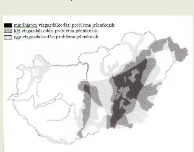
The problems, therefore the sectors too, are connected!
Somlyódy L.: A hazai vízgazdálkodás stratégiai pillérei 2. ábra.
Vízügyi közlemények 2000 3–4 379.oldal
Surface water resources – land
• Is the allocation of land use among the main methods of use effective.
• Is it justifiable to maintain an unbalanced situation?
• If the profitable benefits off-set the costs.
• Benefits: agricultural (option of effective
intensive production structure); infrastructure development; community supporting
• Costs: ineffective activities of environmental protection; the opportunity costs of
undeveloped eco-system services (including the cultural and aesthetic aspects);
• Are the costs of stabilizing production conditions off-set by the produced excess value?
• The economically rational scope of intensity
increasing solutions have been exhausted – if
they were available at all.
The current system of landscape management
Systems built out for water-redirection
• Low-land
– Redirecting excess water: area of inland flood control 44.000 km2, out of which 27.000 km2 is cultivated, 41% of total cultivated area.
– 42.000 km inland water channel; – in 1940 only about 16.000 km – Suction-pump capacity: 1940 200 m3/s; 1995 950 m3/s
• Hill-country
– Second order stream 53.000 km – out of which inland water area is 6.000 km (1.500 settlements with 1.800 streams), 17.000 km “regulated”
– Flood area of streams 4.300 km2 – Erosion-threatened 23.000 km2
Systems built for water-replenishment
• Irrigation
– In 1995 3.170 km2 area accessible for irrigation, 200-500 million m3
– 73% Great Hungarian Plain, 24% Transdanubia, the rest distributed over other hill-areas.
Maintaining the infrastructure of surface and sub-surface water management
• Water administration directorates, water management associations
• Operation means the maintenance of capacities, which is not feasible
• Part of the inland water problems can be traced back to the untenability of capacities
Ownership rights:
• Owned by local
governments and private individuals:
34–39%
• Saleable state ownership (FVM, managing
association): 43–47%
• State-owned water works 18–19%
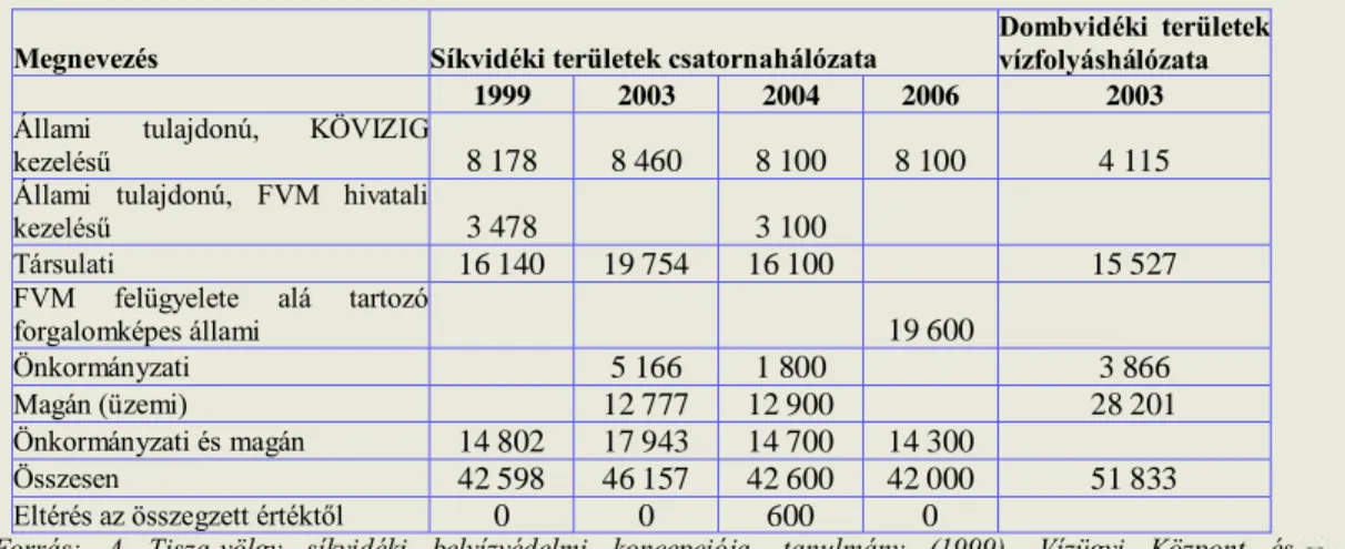
Táblázat A vízfolyás és csatornahálózat hossza, kilométer
Megnevezés Síkvidéki területek csatornahálózata Dombvidéki területek vízfolyáshálózata
1999 2003 2004 2006 2003
Állami tulajdonú, KÖVIZIG
kezelésű 8 178 8 460 8 100 8 100 4 115
Állami tulajdonú, FVM hivatali
kezelésű 3 478 3 100
Társulati 16 140 19 754 16 100 15 527
FVM felügyelete alá tartozó
forgalomképes állami 19 600
Önkormányzati 5 166 1 800 3 866
Magán (üzemi) 12 777 12 900 28 201
Önkormányzati és magán 14 802 17 943 14 700 14 300
Összesen 42 598 46 157 42 600 42 000 51 833
Eltérés az összegzett értéktől 0 0 600 0
Forrás: A Tisza-völgy síkvidéki belvízvédelmi koncepciója, tanulmány (1999), Vízügyi Központ és Közgyűjtemények (2003), Kolossváry-Udvari (2004), Csongrád megyei Földművelésügyi Hivatal tájékoztatója (2006)
Table: Length of water channel and sewage system (km)
Land-use decisions that impact the conditions of water management
• In multi-functional systems, how to charge the costs of infrastructure maintenance and operation to the users
• Communal and private use
• Previously only state subsidiaries, then contributions
• The current financing framework cannot support the planned capacity level – BUT increasing costs is not feasible due to the current activity-pattern of users.
• Financing trap
– Insufficient resources
– Only partially operational infrastructure
– Greater exposure – greater chance of manifestation of random problems – High ration of damage prevention – high operational costs
– Decreasing spending on infrastructure-maintenance
• Changing needs:
– The transformation of agriculture has changed the needs of the primary users
– The transformation of society has changed the needs relating to agriculture / land use.
• For the adaptation of users, that is, changing the demand for the service, the users also need to be aware of the costs of the service.
• For effective land-allocation, it is necessary to
– Know the actual costs of water-system maintenance and
– Know the value of ecological services that materialize as communal benefits (as income for the land user) – VKI notions: cost recovery
– Develop the institutions of governmental demand – market of ecological services
Agricultural water services – irrigation
• Decreasing consumption – despite charges lower than the costs of providing water access
• Socio-political aspects instead of resource-management approaches
• VKJ at times of drought 0 HUF, then completely abolished
• Management anomalies – only those are charged who can be made to pay – fixed charges concentrated on a decreasing consumer base
• Abundance and scarcity at the same time:
• One-third of the annual agricultural water consumption manifests during the
highest-demand period of the year (July- August). At the same time, out of the VKI’s 42 planning sub-unit the narrow- bore water yield does not reach this ratio in 33 cases. It is necessary to retain water between periods.
• Even those that could pay do not have access.
• (The conflicts of maintaining fishing ponds – unpaid ecological services)
Mezőgazdasági vízfelhasználás alakulása 1970-2004
0 200 400 600 800 1000 1200
1970. 1975. 1980. 1985. 1990. 1992. 1993. 1994. 1995. 1996. 1997. 1998. 1999. 2000. 2001. 2002. 2003. 2004.
Agricultural water-consumption 1970–2004
A mezőgazdasági vízfelhasználás alakulása, millió m3
Megnevezés 2000 2001 2002 2003 2004 Megoszlás 2004
Halastó ellátására 505,5 502,4 463,2 456,3 385,9 64%
Öntözés 178 180,2 186 184,5 182,2 30%
Állattenyésztés 28,7 29,3 28,9 29,2 27,9 5%
Egyéb 8,5 4,4 1,5 0,0 6,4 1%
Mezőgazdasági saját víztermelés összesen 720,7 716,3 679,6 670,0 602,4 99%
Viziközműtől vásárolt víz 4,8 4,1 4,7 3,8 3,4 1%
Mindösszesen 725,5 720,4 684,3 673,8 605,8 100%
Agricultural water-consumption, million m3
Water management controversies in the region
Source: Simonffy, Vízügyi közlemények 2000/3–4
Changes in the size of irrigable areas km2 based on resources accessible at low-water
FORGATÓKÖNYVEK ÉGHAJLAT VÁLTOZÁS NÉLKÜL
FELSZÍ- NI VÍZBŐL
FELSZÍN ALATTI VÍZBŐL
ÖSSZE- SEN
1 Jelenlegi viszonyok 3 800 950 4 750
2 1 + A mederben hagyandó hozam 50%-kal nő 3 550 950 4 500 3 2 +Külföldön lefolyás csökken, vízhasználat nő,
tervezett tározók megépülnek 3 100 950 4 050
4 3 + Technológiaváltás (víztakarékos öntözés,
kedvezőbb vízigényű növények) 3 900 1 200 5 100
5 4 + Gazdaságosnak ítélt átvezetések 4 450 1 200 5 650
FORGATÓKÖNYVEK ÉGHAJLAT VÁLTOZÁS ESETÉN
FELSZÍ- NI VÍZBŐL
FELSZÍN ALATTI VÍZBŐL
ÖSSZE- SEN
6 (3) + enyhe éghajlat változás, 0,3 C 2 050 850 3 100
7 (3) + közepes éghajlat változás 0,7 C 1 600 800 2 400
8 (3)+ közepes éghajlat változás, szárazabb hazai
változat 1 050 700 1 750
9 (7) + technológiaváltás (víztakarékos öntözés,
kedvezőbb vízigényű növények) 2 000 1 000 3 000
10 4 + Gazdaságosnak ítélt átvezetések, további hazai és
külföldi tározási lehetőségek 2 850 1 000 3 850
km
2km
2• Irrigation is not a solution to
regional water scarcity. There is not enough
summer surface
water resource
that would be
comparably
sufficient.
The connection between land use and water quality
• Millennium Ecosystem Assessment – identifies overnutrition as one of the key drivers of eco-system degradation
• Water Framework Directive survey:
– 33% of flowing waters, 26% of static Waters – 50% of natural flowing waters is affected – Quantity of load
• Point sources of water pollution 2,9 kt/year,
• Non-point sources of water pollution 2 kt/year, out of which 85% is agricultural
– Reason: proximity of plough-lands, lack of puffer area
• Diffusive load and erosion = Damage to nutrient cycle and loss of soil
• Diffusive load on low-lands results from redirecting inland water
The connection between diffusive and erosion – area distribution
Water Framework Directive
The Hungarian section of the Duna‘s water reservoir
Point-based diffuse rate
Flood risk management of the river Tisza
Cost-benefit analysis, results
NKFP – 3/A 0039/2002
The increase of the height of flood prevention embankments based on Vágás I
Growing danger of flooding – a hopeless endeavor
• The defense system itself perpetuates the risk – flood storage of dams filling up
• The changing land- use
decreases the effectiveness of the defense system – meeting of floods due to quicker run-off
• Negative effects of climate
change – uneven distribution of annual rainfall – rainfall
concentrated to winter months and growing amount of rain falling at individual instances
Szlávik Lajos: A Tisza-völgy árvízvédelme és fejlesztése, Földrajzi Konferencia, Szeged 2001
http://geography.hu/mfk2001/cikkek/Szlavik.pdf
Dr. Kovács, Váriné: A Vásárhelyi-terv továbbfejlesztését megalapozó hidrológiai és hullámtér hidraulikai vizsgálatok eredményei a Közép-Tiszán
http://www.vizugy.hu/vir/vizugy.nsf/0/361e6f4e45d0f1fbc1256e5b004d64a8?opendocument#2%c3%81
Methodology
• Comparable versions of run-offs
– Effects of climate change considered, the process of floodplains silting up
• Cost-benefit analysis
– Finding the combined minimum of expenditures and damages – Calculating costs incurred at different times on present value
• Data
– Damages: residential goods and properties; public buildings;
evacuation; industrial, agricultural and road damages
– Investment; maintenance; defense
NKFP – 3/A
0039/2002
Cumulated damage at disaster points by damage types
0 10000 20000 30000 40000 50000 60000 70000 80000 90000 100000
24 20 22 10 30 16 7 19 18 5 1 11 4 21 3 15 6 12 17 23 2 27 28 14 29 9 13 8 26 25
mezőgazdasági kár átlaga
ipari kar kat.pont szamitas alapjan [mill.ft]:
utkar[mill.ft]:
kitelepitesi ktsg[millio]:
ingosagok kara[millio]:
elarasztott teglalakas 2 kar[millio]:
• The distribution of disaster points
– Residential 22% – Evacuation 12%
– Industrial damage 40%
– Agricultural 3%
– Road damage 22%
– Strong concentration: the top 20% of disaster
points have 47% of the damages, the bottom
40% have 20% of the damages
-0,2 0 0,2 0,4 0,6 0,8 1
0 20000 40000 60000 80000 100000 120000
Millió Ft
p
alap helyzet mélyártér vtt6 vtt11
No dam- construction (MÁSZ+0) scenarios
-0,2 0 0,2 0,4 0,6 0,8 1 1,2
0 5000 10000 15000 20000 25000 30000 35000 40000
Millió Ft
p
töltés mélyártér vtt6 vtt11
0.5 meter dam-
construction (MÁSZ+0,5) scenarios
-0,1 0 0,1 0,2 0,3 0,4 0,5 0,6 0,7 0,8 0,9 1
0 2000 4000 6000 8000 10000 12000 14000 16000
Millio Ft
p
töltés mélyártér vtt6 vtt11
1 meter dam-
construction (MÁSZ+1) scenarios
Várható kárérték és csökkenése, 3% diszkont ráta mellett
Sorrend Az összesített várható árvízi kár
jelenértéken Mrd Ft
Kár csökkentés különbsége MÁSZ+0-hoz képest*, jelenértéken, Mrd Ft
Szcenáriók
1 14 1610 VTT11 MÁSZ+1
2 25 1600 VTT11 MÁSZ+0,5
3 32 1593 VTT6 MÁSZ+1
4 32 1593 Mélyártéri árapasztás MÁSZ+1
5 56 1569 MÁSZ+1
6 82 1542 Mélyártéri árapasztás MÁSZ+0,5
7 90 1535 VTT11 MÁSZ+0
8 97 1528 VTT6 MÁSZ+0,5
9 282 1342 MÁSZ+0,5
10 319 1306 Mélyártéri árapasztás MÁSZ+0
11 538 1087 VTT6 MÁSZ+0
* a MÁSZ 0 scenárió várható kárértéke 1614 Mrd Ft.
Expected damage-value and its decrease, with 3% discount rate
Results
Overall Costs
Mrd Ft Order
Expected damage Mrd Ft
Expenditure Mrd Ft
MÁSZ+0 – alaphelyzet 1747 1624 122
VTT6 MÁSZ+0 692 11 538 155
MÁSZ+0,5 454 10 282 172
VTT11 MÁSZ+1 405 9 14 390
Mélyártéri árapasztás MÁSZ+0 397 8 319 78
VTT6 MÁSZ+1 360 7 32 329
VTT6 MÁSZ+0,5 327 6 97 230
MÁSZ+1 311 5 56 255
VTT11 MÁSZ+0,5 309 4 25 284
Mélyártéri árapasztás MÁSZ+1 295 3 32 264
VTT11 MÁSZ+0 284 2 90 194
Mélyártéri árapasztás MÁSZ+0,5 242 1 82 159
with 3% discount rate
Comparing flood control strategies on the River Tisza, Refining the Vásárhelyi Plan
A Tisza árvízi szabályozása a Kárpát-medencében NKFP – 3/A 0039/2002 BME Víziközmű és Környezetmérnöki Tanszék
Az árvízi védekezési rendszerek várható ráfordításai a Tisza magyarországi szakaszán, MrdFt, 3% diszkontláb mellett, a vizsgált 100 éves időszakra
0 200 400 600 800 1000 1200 1400 1600 1800 2000
Mélyártéri árapasztás és 0,5 méter gát emelés 11 Tározó gát emelés nélkül Mélyártéri árapasztás és 1 méter gát emelés 11 tározó és 0,5 méter gát emelés 1 méter gát emelés 6 tározó és 0,5 méter gát emelés 6 tározó és 1 méter gát emelés Mélyártéri árapasztás gát emelés nélkül 11 tározó és 1 méter gát emelés 0,5 méter gát emelés 6 tározó gát emelés nélkül
Alaphelyzet Beruházási költség
Védekezési költség Árvízi elöntés kár értéke
Mélyárterek elárasztása Mélyárterek elárasztása
The shift the current VTT Act aims at reaching
within 25 years
Expected expenditure on flood control defense strategies for the Hungarian section of the Tisza, Mrd HUF with 3% discount rate, projected for 100 years
Comparing flood control strategies on the River Tisza, as part of the Vásárhelyi Plan
A Tisza árvízi szabályozása a Kárpát-medencében NKFP – 3/A 0039/2002 BME Víziközmű és Környezetmérnöki Tanszék Az árvízi védekezési rendszerek várható kárértékei a Tisza magyarországi szakaszán,
MrdFt, 3% diszkontláb mellett, a vizsgált 100 éves időszakra
0 100 200 300 400 500 600 700 800
Mélyártéri árapasztás és 0,5 méter gát emelés 11 Tározó gát emelés nélkül
Mélyártéri árapasztás és 1 méter gát emelés 11 tározó és 0,5 méter gát
emelés
1 méter gát emelés 6 tározó és 0,5 méter gát
emelés
6 tározó és 1 méter gát emelés Mélyártéri árapasztás gát
emelés nélkül 11 tározó és 1 méter gát
emelés
0,5 méter gát emelés
6 tározó gát emelés nélkül Beruházási költség
Védekezési költség Árvízi elöntés kár értéke
Turning to integrated strategies of water-retention and land usage adaptation
is necessary
Expected expenditure on flood control defense strategies for the Hungarian section of the Tisza, Mrd HUF with 3% discount rate, projected for 100 years
Eco-system services of floodplains – mitigating functions – 1
Overall costs Mrd Ft
Decrease in relation to the
embankment- construction scenario Mrd Ft
Shift in terms of 1 hectare of used area millFt/ha
MÁSZ+0 – alaphelyzet 1747
Mélyártéri árapasztás MÁSZ+0 397 1350 10,4
MÁSZ+0,5 454 1293
Mélyártéri árapasztás MÁSZ+0,5 242 212 1,6
MÁSZ+1 311 1436
Mélyártéri árapasztás MÁSZ+1 295 15 0,1
Changes in the VTT-concept – unfulfilled opportunity
• Solutions provided by the current plan and questions left unanswered
– Decreasing flood tide only, without water replenishment or
– Land usage accommodation, landscape water replenishment with protection functions
• Tarpa 2001 – First aim: decreasing the water-level tide of the rare great floods.
Minimal area required – great water-depth – high specific costs of investment – with the passing of the flood the redirecting the water into the river
• Planning efforts to coordinate flood-control, agricultural, conservational aspects, resulting in the 2004/LXVII VTT Act
• The regression of the plan – failure to reach the necessary cooperation due to the lack of governmental coordination and due to specific lobby interests – VTT 1003/2007 Government decree
– Water surplus remains to be diverted between dams – Implementation is expanded to a 25-year duration
– Rate of implementation conditioned by prospective available funds
The planning area of the
regional
development of
the VTT
Landscape management in the Bodrogköz floodplains
Cigánd emergency reservoir and the connecting Tiszakarád landscape management model area during high water
Landscape management in the Bodrogköz floodplains
Cigánd emergency reservoir and the connecting Tiszakarád landscape management model area during low water