pp. 263 – 278 doi: 10.7427/DDI.18.17
17. Changes in the state territory, systemic changes, the development of ecological thinking and the issues of the utilisation of hydroelectric power in Hungary
HAJDÚ Zoltán, HARDI Tamás
Hungarian Academy of Sciences – Centre of Regional Studies – West Hungarian Research Institute: 10 Liszt F: street, Győr; H- 9022; Hungary
Author responsible for correspondence: HARDI Tamás - Hungarian Academy of Sciences – Centre of Regional Studies – West Hungarian Research Institute: 10 Liszt F. street, Győr; H-9022; Hungary; e-mail: hardit@rkk.hu
BSTRACT.
Each big river, including the Danube, makes a single system from their spring to their delta or estuary. Wherever we intervene into the system, this will be necessarily affect the whole of that. The spillover effects are especially striking in the case of the lower reaches, in the Danube River in the Delta area. The utilisation of the hydroelectric power of the Danube River has been continuously on the agenda in the Hungarian areas since the turn of the 19th and 20th centuries, as an economic, planning, development and then political and environmental issue. The plans made before the World War I featured hydroelectric plants as the carriers of technical and scientific progress. World War I and the subsequent changes of the state borders swept these plans aside. Between the two world wars, the planning of hydroelectric power stations on the Danube was continued within the new state borders, two Hungarian governments and prime ministers of the time were fully committed to the construction of three power plants on the Danube River. After World War II, the hydroelectric plant planned on the Hungarian-Czechoslovakian border and its construction became a basic economic and, from the 1980s, an environmental issue. Finally, only a part of the planned hydroelectric power plant system was constructed, and the issue was not finally closed by specific interpretation of the international law. The Danube Strategy of the European Union, the programmes until 2020, the increase of the role of renewable anergies, the nuclear disaster in Japan, and the interests of international navigation filled the debate with new content. The possibility of the construction of hydroelectric power plants on the Danube River was “accidentally” put among the official documents of the government in power since 2010. The government declared it had nothing to do with the plans, and the debate has been going on since then.Key words: hydroelectric power plant, socio-economic debates, Danube, Hungary
INTRODUCTION
A dominant element in the modern Hungarian social, economic and political development is the “pulsing” change of the state structures, the state borders and the state territory of Hungary during the 20th century. There are practically no internal processes that can be understood without these fundamental changes. The transitions of the state structures coincided in most of the cases with social, economic and political transformations (systemic changes), and in the frameworks of these transitions the results of practically all former processes were reconsidered.
The judgement by public policy of the academic researches assessing the topical resources available for the state also changed continuously, parallel to these transformations. These changes are especially striking if we look at the changes in the use of hydroelectric power potential. It does matter within what state territory and at what state boundaries the strategies, concept and plans were made.
The regulation of water related issues was actually a constant element on the agenda of Hungarian legislation since 1840. The political elite of each era knew that the issue of waters demanded a long-term strategy for Hungary. The Hungarian concepts made for the utilisation of hydroelectric power included, from the beginning, the issues of environmental protection, water protection, and the preservation of the cleanliness of water. It was not the “water men” that were a threat for the environment. Environmental debates were focused in the issues of the Gabčikovo-Nagymaros Hydroelectric Power Plant, after the late 1970s, and after 1988 the environmental movements became political, still later system-changing movements.
After 2004 – the acquisition of the EU membership by Hungary – the issues of the utilisation of renewable energies (including hydroelectric power) appear within the European Union. The energy policy and the Danube Strategy of the EU do not clearly settle the basic issues; the debates are still going on within the country and also among the countries, see the disputes between Hungary and Slovakia over the utilisation of the Danube River.
A
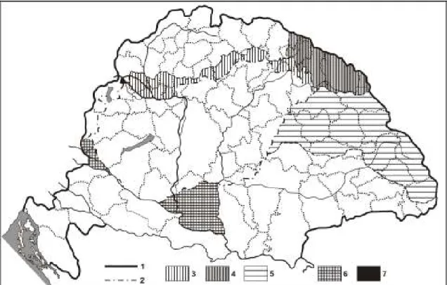
THE SCIENTIFIC ASSESSMENT AND EVALUATION OF THE HYDRO-ELECTRIC POTENTIAL OF HUNGARY Science studied, analysed and evaluated within the state territory of the time (Fig. 1) the natural resources of Hungary. The resources thus had to be defined and redefined, evaluated and re-evaluated within the changing boundaries of the country.
Fig. 1. Territorial changes of Hungary in the 20th century (ed. by Z. Hajdú)
Notes. 1. – historical state border, 2. – state border after 1921 and 1947, 3. – territorial gain of 1938, 4. – territorial gain of 1939, 5. - territorial gain of 1940, 6. - territorial gain of 1941, 7. - territorial loss of 1947.
In Hungarian public thinking, economic policy, legislation and science, the protection against floods, the regulation of rivers and the draining of marshes had great importance since the middle of the 19th century. Because of the specific historical endowments of the historical Hungary – closed basin character – the relation of Hungary to waters became an issue of strategic importance. Flood protections and river regulations were the first appearances of thinking and planning in large physical geographical systems, networks, complicated macro- regional, regional and local impact mechanisms. By the flood protections and river regulations the Hungarian society implemented one of the largest and most successful nature transforming projects in Europe.
Act No. XIII. of 1885 (on the rights to water), almost exclusively in Europe at that time, provided a comprehensive regulation in water related issues. The legal regulation mentioned all aspects of the utilisation of waters.
In the late 19th century both Hungarian economy and science were faced with the new possibilities and challenges related to the utilisation of hydro-energy for electricity production. The need for the assumption of hydro-electric potential as a basic issue related to waters was most suggestively defined by Jenő Kvassay, leader of an organisation with national competency called Hungarian National Hydroengineering and Soil Amelioration Office belonging to the Ministry of Agriculture (1889), after 1899 the director of the Hungarian National Hydroengineering Directorate. Kvassay saw that the solution of the scientific issues was a task for the state, market actors could not be expected to organise and finance works of such magnitude. In the utilisation of the potentials explored, individuals, businesses, municipalities and the state itself could participate.
The exploration of the hydro-energetic potential was first considered primarily as an economic issue, and the environmental aspects were only raised as an auxiliary factor, although from the very first moment, already. The government acknowledged “the implementation of this necessary economic research as its own task” and provided finances for the work, and also for the full publication of the research findings in 1905. The hydro- energetic potential and its utilisation were considered as an economic and economic development issue from the start of the work. Many thought that Hungary was unaware of her own hydro-energetic resources and found it important that “Public interests demanded that the cloud hiding our hydro-powers be dissolved soon...” [64].
The objectives and frameworks of the general assessment of hydro-energetic potential were defined by a decree of the minister (the general programme of studies and assessments needed for the approximate definition of the hydropower in the rivers of Hungary). After comprehensive preparations (the utilisation of international experiences was planned but it was soon found that the works on the assessment of the hydro-energetic potential of the mountain rivers had just started in other countries too, so the Hungarian water management and energetics experts actually had to work out their own methodology). The works started in the summer of 1897 by the assessment of the hydro-energetic potential of the Vág (in Slovak: Váh) River and the primary assessments were practically done in the mountainous areas by 1903 (on the whole, the government spent approximately 276 thousand Crowns in 1897-1908 on the assessment of the hydro-energetic potential of Hungary.)
The assessment, the in-depth field work covered two-thirds of the mother country (excluding Croat-Slavonia), the hydro-energetic resources of the Danube and Tisza Rivers in the Great Hungarian Plain territory were not analysed. During the assessment only the natural hydro-energetic potentials were recorded, the implementers of the assessment did not calculate with the construction of reservoirs at the time of the research. According to the decree of the Minister of Agriculture, only waters in excess of 100 horse powers had to be taken into consideration during the general assessment. In practice, however, rivers with smaller capacities were also assessed, especially in the then North Hungary and Transylvania.
The main findings of the assessment were as follows:
- In the mountainous and hilly areas between the upper limit of free navigation and the lower limit of unutilisable river reaches, using the amount of water also available in the time of the autumn drought, a theoretical amount of approximately 2.7 million horse powers was available;
- for “practical life”, however, only rivers producing 20-50 horse powers could be taken into consideration, which reduced actually available hydro-energetic potential to 1.7 million horse powers, which was utilisable at the given technical level of the time.
During the survey only the potential energy of the respective river reaches were recorded, the possible locations of hydro-electric power plants were not designated exactly. This was the responsibility of investors, planners and to some extent also the job of other experts.
In the first phase of the research already it became clear that “The orographic conditions and the ethnic diversity of our country result in the sad circumstance that the larger part of our mightiest hydro-powers is situated in ethnic minority inhabited, in many cases culturally underdeveloped regions” [64]. This means that after the turn of the century the issues of hydro-electric power plants always went together with ethnic minority policy and regional policy considerations, beyond the economic ones. The political environment of the construction of hydro-electric power plants in the first period was impacted, partly determined by economic and ethnic minority aspects. The majority of the experts of hydrology supported the development of the ethnic minority inhabited regions.
UTILISATION OF HYDRO-ENERGY WITHIN THE FRAMEWORKS OF THE AUSTRO-HUNGARIAN MONARCHY IN THE HISTORICAL HUNGARY
Act No. XXIII. of 1885 as the basic act of Hungarian water management was a regulation of European standard in almost all respects. On the basis of Paragraphs 189 and 190, approximately 20 thousand requests were submitted for the utilisation of hydro-energy (only a smaller part of which were constructed hydroelectric power plants), and 16 thousand of these were located in the mountainous and hilly areas surveyed by Ede Viczián. The large number of applications “covered all possibilities of utilising hydro-energetic power”; there are practically no hydroelectric power plants planned or designed in the Carpathian Basin whose past does not go back to this primary phase of the submission of demands.
The aspects of water and environmental protection appeared very early in Hungarian water management legislation. The act of 1885 on the right to water definitely prohibited the pollution of the rivers.
When introducing the utilisation of hydro-energy it must be mentioned that in the late 1870s the first small private power plants producing electricity were constructed (Csernahévíz -currently Topleț, Romania- 1878). The new power plants were made on the millennium anniversary of the Hungarian Conquest – in Abrudfalva (now Abrud- Sat, Romania), Besztercebánya (now Banská Bystrica, Slovakia), Czód (now Sadu, Romania), Kassa (now Košice, Romania), Zólyombrézó (now Podbezová, Slovakia) – , representing the new Hungarian creative power.
From the beginning of the construction of hydroelectric power plants in Hungary, references to foreign examples could be seen. In the early 1900s the primary subjects of interest and references were the constructions of dammed reservoirs in Germany. Until 1910 a total of 49 reservoirs were constructed in Germany, allowing the storage of 302 million m3 of water, and the electricity produced could be immediately sold everywhere.
The modern large capacity reservoirs of Hungary were built in the 1900s. The city of Kolozsvár (now Cluj Napoca, Romania) built their 21 metre high dam in the valley of the Hidegszamos River in 1906 at the village of Hidegszamos (now Someșul Rece, Romania), behind which a daily amount of 50 thousand m3 of water was stored. The theoretical capacity of the power plant was 1,670 horse powers. This power plant played a significant
role in the electricity supply of the city. The iron works of Resica built in 1909 in the valley of the Berzava River, at Ferenczfalva its 27 metre high dam that held back 1.2 million m3 of water a year. The electric power produced was primarily consumed by the local industry, but in some settlement public lighting was also built out.
According to the Act No. XVIII. of 1913, the importance of the hydroelectric power plants could be seen in two things: on the one hand, they substitute coal, an energy source that Hungary did not have much, and they largely contribute to the development of the Hungarian industry by the production of cheap electricity, on the other hand.
The act regulated in details the procedures to be followed at the construction of hydroelectric power plants.
In the construction of “hydroelectric plants for public use” private persons, businesses and also municipalities participated, but power plants were also built by different companies belonging to the Hungarian State Treasury.
Of the 72 public use hydroelectric plants constructed until 1914, the bigger ones were owned by cities - Temesvár (now Timișoara, Romania), Kolozsvár (now Cluj Napoca, Romania), Nagyszeben (now Sibiu, Romania), Rozsnyó (now Rožňava, Slovakia), Kassa (now Košice, Slovakia), Eperjes (now Prešov, Slovakia), Besztercebánya (now Banská Bystrica, Slovakia) etc.- . The power plants were usually built with 1 turbine or 2, the power plant of Ikervár, with a theoretical capacity of 2,200 horse powers, was rather an exception with its 5 turbines at its inauguration in 1895. On the whole, the hydroelectric power plants utilised 27,802 horse powers measured on the axis of the turbines [7].
One of the most important issues of the time was the provision of Budapest with electric power. On the basis of his own researches, József Benedek believed that the cheap and certain supply of Budapest with electric power could only be secured by large power plants constructed on the Vág River. He planned a power plant complex suitable for the storage of 1 billion m3 of water in the region of Árva (now Orava, Slovakia). The management of the capital city discussed possible financing several times, but the war and then the changes of the borders blocked the implementation of the plans. According to several contemporary calculations, one single dam of 40 metres height built on the Vág River could be enough for the storage of 1 billion m3 of water. The power of the water held back by the dam could be enough for a 220 thousand horse power plant, and the Vág River could be made navigable right up to Ruttka (now Vrútky, Slovakia). The sales of the electric power produced could not be a problem, because in addition to the western part of the former Northern Hungary, natural potential markets were Pozsony (now Bratislava, Slovakia), Győr and even Budapest [9].
In the hydroelectric power plant construction policy of the Danube River a significant position was held by the regulation of the Soroksár branch of the river and the construction of the small dam and power plant at Tass [54], as well as the start of the planning works related to the regulation of the Moson Danube in 1911. The use of the power potential of the Danube River for electricity production was defined from this time on as a function of the topical political and technical possibilities.
Jenő Kvassay, analysing the Hungarian water management policy during World War I saw that the utilisation of the power of the rivers and water storage had to be an integral part in that policy. International experts estimated the value of 1 hydro horse power to be 3,000 Crowns, and accordingly the potential value of the water power potential of Hungary could be 4-5 billion Crowns [28]. In Kvassay’s view, Hungary had to be divided into 70-100 districts for electricity production, and in each district a power producing plant had to be built. The electrification of Hungary would last for about 20-30 years and cost approximately as much as the construction of the short train network of the country (3 billion Crowns).
Kvassay also defined the need for intensive water protection, not only as an issue of environmental protection and economics but also as a state and administrative task. The state and public administration must pay a selected attention to the protection of the waters and their environment. In Kvassay’s opinion Hungary was in the front line of the protection of waters: “We are lucky to have solved this issue in its initial phase when industrial pollution was not as extended as in the western, industry-pursuing states” [28].
The first licensed plan for the use of the hydroenergetic power of the Moson Danube was the so-called Buss Concession. Buss A. and his partner (Basel) received as soon as in 1918, in the framework of a regular water law procedure, permission to pump out from the riverbed a minimum of 100 m3 at the lowest water level and maximum of 400 m3 at higher levels upstream Pozsony, on the right bank of the Danube River branch, and to direct a maximum of 200 m3 of this amount into the Moson Danube to produce electricity in 3 hydroelectric power plants on the right bank of the Danube River. The planned volume of electricity produced was 16 thousand horse powers in the worst case and 42 thousand horse powers in ideal conditions.
The bulk of concepts related to the energetics use of the Iron Gate is a very interesting issue both from the aspect of hydrology and hydroenergetics. A creation of large significance from the aspect of Hungarian hydroelectric power plant plans is Bánki’s plan for the hydroelectric power plant of the Iron Gate [1]. This plan was at the highest level of that time from all aspects, and in addition to energy production it would have also given a final solution for the navigation problems in one of the most problematically navigable reaches of the Danube River.
The contemporary belief was that it (would have) appeared as the mightiest creation of the Hungarian spirit and will, the Hungarian genius.
There were many opposite interests against the construction of the power plant (the danger caused by the height of the backwater, selected development of ethnic minority inhabited areas etc.), but the hydroelectric power plants were usually seen as the achievements of development and modernisation, cutting edge technology and the symbol of the Hungarian creative potential both in public thinking and academic publications.
THE ISSUE OF HYDROELECTRIC POWER PLANTS IN THE TIME OF THE POLITICAL AND TERRITORIAL RESTRUCTURING AND CHAOS (1918-1920)
In the time of the collapse induced by World War I, Pál Teleki established already in October 1918 the Peace Preparation Office, with the task of preparing Hungary for the coming peace talks on scientific bases, with the full exploration of the internal structure of the country. Geographers, economists, statisticians, hydrologists, historians etc. participated in the works of the peace preparation. Teleki considered as the primary task the preservation of the unity of the historical Hungary and accordingly favoured those approaches that tried to define the preservation of the territorial unity in the light of international science and the international interests.
During the Council Republic – on the ground of his former left-wing activity but besides a professional qualification of European standards – Ödön Bogdánfy was the leader of the Hungarian National Hydroengineering Directorate of the Ministry of Agriculture. (Bogdánfy wad committed both in his practical and political activity to the mass construction of hydroelectric power plants.) The utilisation of hydropower for Bogdánfy was primarily a water management and economic policy issue.
In the preservation of the territorial unity of Hungary a key role was assigned to the proof of the hydrological unity of the country, including the utilization of hydro-energy. The hydroelectric power plants were defined as the most important units of the Hungarian energetics sector. In their memorandum called ‘The geographical unity of Hungary’ – mostly written by Jenő Cholnoky – the Hungarian peace talk delegation argued that Hungary in all respects was the most perfect, most closed geographical formation in the whole of Europe, maybe the whole world.
The disintegration of the hydrological unity based on the complex orographic unity would be tragic not only for Hungary but also for the successor states.
In the declaration called the Hydrological unity of Hungary – primarily written by Ede Viczián – the water management unity of the historical Hungary was highlighted, including the “utilisation of hydropowers”. The planned new state borders would detach almost the whole of the hydropower potential from Hungary. The Hungarian declaration demanded the amendment of the water management articles in the peace conditions handed over to Hungary.
The document called ‘The Hungarian energetics economy’ worked out by the Hungarian delegation also discussed the importance of hydropower and the negative impacts of the potential detachments as a basic issue:
“After that even the hydropower would fail to assist the survival of this remaining but doomed to death country from the subsequent huge shortage of energy\” [9].
The author of the peace talk document called ‘Hydropowers of Hungary’ was also Ede Viczián as a member of the peace talk delegation; he published his analysis in a separate booklet [65]. The energy supply of the Carpathian Basin was defined as an economics issue of European significance. In 1910 Hungarian industry used 49 thousand hydro horse powers. For Hungary the best solution was the utilisation of hydroenergetic power at that time. Mountain rivers and streams could be utilised, and after the development of the technology also the Danube and Tisza Rivers. In Viczián’s opinion the total theoretical hydroenergetic potential in the territory of the historical Hungary was approximately 2.7 million theoretical horse powers. The largest hydroelectric power plant could be built at Orsova (now Orșova, Romania), with a capacity of approximately 320 thousand horse powers.
The most suitable location for the other large Danubian power plant was Pozsony, the capacity here was some 50 thousand horse powers.
The Hungarian peace talk delegation made special efforts to highlight the flood threat in the valley of the Tisza River, in case the north-eastern part of the Carpathian Mountains is detached from the country. They separately demonstrated the correlations between the mountain reservoirs and the preservation of the territorial integration of Hungary. Mountain reservoirs serve four purposes: 1. utilisation of the energy of the water, 2. navigation, 3.
irrigation, 4. blocking of floods. According to the Hungarian viewpoint demonstrated on the peace talks, in the Upper Tisza Valley 3-4 large reservoirs could and should be constructed to store a total of 6-700 million m3 of water. The backwater could be used for the operation of hydroelectric power plants with a stable 100-120 thousand horse power capacity, which would result in saving 1.5 million tons of coal.
In the explanation of the plans it was stressed that the economical operation of the power plants could not be secured in themselves, so it was not possible to make private capital interested in the construction of hydroelectric power plants. This is an area where only the state can build the hydroelectric power plants, because it is the state that can make natural rearrangements among different impacts (energy production, irrigation, navigation, protection against floods) and profitabilities.
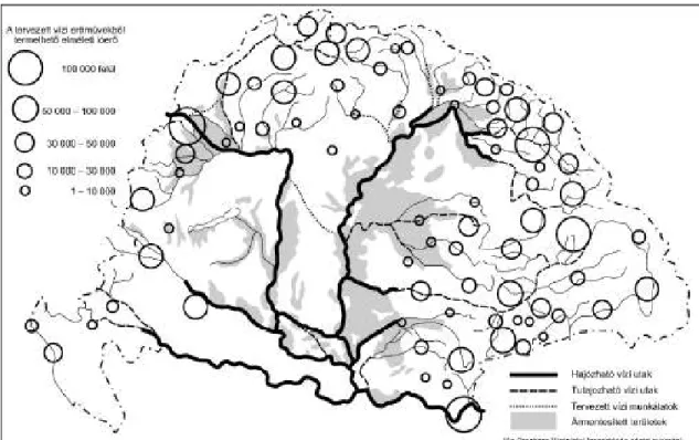
A large amount of water management, power plant policy etc. maps were made for the peace talks, of which one of the most interesting and comprehensive is the map showing the network of power plants and electricity supply worked out by J. Benedek, K. Kandó and E. Viczián (Fig. 1), giving a complex view of the concept of mountain power plants and a 1,700 kilometres long national electrical power cable network supplying Budapest. A single network of hydroelectric power plants built in the territory of the Carpathian Basin at the technical level of the time would allow the saving of 19.4 million tons of coal annually. The Carpathian Basin could theoretically cover its total energy consumption form hydroelectric power plants.
Károly Kogutowicz, as a member of the staff of the Peace Preparation Office, dealt in a comprehensive way with the hydroengineering constructions in the Carpathian Basin. In the opinion of Kogutowicz, after the flood protection and river regulation works it was a logical, in fact, necessary step to optimally utilise the hydropower potential of the Carpathian Basin (Fig. 2). The river regulation and flood protection works, and the network of hydroelectric power plants would complement each other spatially and functionally.
Fig. 2. Flood protection and river regulation works and the hydropower potential of the Carpathian Basin Notes. Edited by Károly Kogutowicz, 1921. IN: Bátky (Zs.), Kogutowicz (K.), (eds), 1921 - Kogutowicz zsebatlasza az 1922.
évre [2]
In 1918-1920 the power plant policy served the preservation of the territorial unity of Hungary, all other aspects of this policy were of secondary importance. In social policy issues both the right wing and the left wing part of the engineers’ collective were committed to the construction of hydroelectric power plants and the programme for the preservation of the territorial unity of the country, they saw hydroelectric power plants (also) as the symbols of the economic and technical progress of Hungary.
PROBLEMS OF THE HYDROELECTRIC POWER PLANTS OF HUNGARY IN THE BOTTOM OF THE CARPATHIAN BASIN BETWEEN THE TWO WORLD WARS
Until 1918 the judgement of the construction of hydroelectric power plants was seen as a basically ethnic minority, national economy and economic policy issue, and also as a special issue of navigation and agricultural irrigation.
The state primarily financed scientific researches, while private capital and municipalities financed the plans of the power plants and to some extent also their construction.
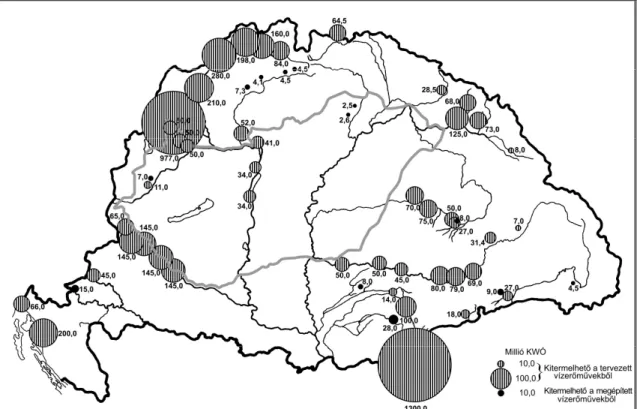
Within the new state territory, the first issue in the focus was the management of flood protection tasks adjusted to the new borders. Hydropower and hydroelectric power plants were most frequently mentioned on the “list of losses” suffered at Trianon. Approximately 5.5 per cent of the former hydroenergetics potential was estimated to have remained within the new borders of Hungary (Fig. 3). This also meant that the economic significance of the issue at national economy level was fundamentally different.
Fig. 3. The Peace Treaty of Trianon fundamentally changed, among other things, the hydroenergetic potential of Hungary
Notes. Source: Edvi Illés and Halász (eds.), 1921 [10].
The relationship between hydroelectric power plants and the environment gradually became a focal point. From this aspect it is especially important to know the environment concept of geography and its changes. Jenő Cholnoky as one of the leading persons of the modern Hungarian physical geography between the two world wars was a hydrologic engineer, as regards his original profession. In Cholnoky’s view hydrologic engineering was one of the most important fields in the humanisation of the geographical environment.
In the period between the two world wars, in the Hungarian geographical science it was István Dékány who gave the most general definition of the need for a new approach to the relationship between man and nature (Dékány 1924). The basic element in Dékány’s approach is that we should get rid of those theories that consider mankind as an object suffering the impacts of the environment. Man “has become a subject”, in his special way he has also an impact on his environment that he transforms. In this new environmental philosophy and geophilosophy approach the transformation of nature became a positive objective and value. In Dékány’s view the most important task of economic geography is to demonstrate economic value as the transformation of geographical value.
The relationship between politics and science was quite spectacular in the academic activity of Pál Teleki and Miklós Kállay. Teleki stated already in 1917 that in order for economic geography to become part of the geographical sciences “it has to integrate its object into the whole life process of the environment” [58]. Pál Teleki geographer and Miklós Kállay hydrologic engineer were dedicated “power plant builders” both as scientists and prime ministers. Both academic politicians made commitments several times in both their theoretical and political and practical activities for the continuation of the hydroengineering works and the construction of hydroelectric power plants.
The right-wing Ede Viczián and the left-wing Ödön Bogdánfy – until their death in 1931 and 1944, respectively – remained dominant ideologists of the Hungarian hydroelectric power plant construction movement (for them hydroelectric power plants were not an issue of political orientation but an opportunity of the national economy to be supported), but a new generation who had to think in terms of plain land power plants gradually grew up.
The idea of the construction of the Danubian hydroelectric power plant at Visegrád was first raised in a serious form in the very beginning of the 1920s. Swiss power plant construction companies started concession talks with the Hungarian government and the academic researches related to the construction also started. The Swiss wanted to build a dam between Nagymaros and Kismaros. According to the memories of Aladár Vendl in 1951, geological and other examinations were done at the Technical University of Budapest, led by Ferenc Schafarzik.
The actual implementation works did not start.
From the beginning of the 1920s, for the new Hungary in the bottom of the Carpathian Basin the whole water utilisation strategy and policy had to be reconsidered. In the field of energy policy, the issue of hydroelectric power plants was raised again, party in the function of international processes. Looking at the possibilities and constraints of water management policy in the new situation, Sándor Rotringer came to the conclusion that the importance of hydro-energy had decreased in the new state territory, but hydroelectric power plants were still important as they “put relaxed security into production”. In the utilisation of hydro-energy the cooperation of the state and private capital was necessary. The main task of the state is the support of researches: “In the field of hydropowers we have achieved a sound knowledge, on the ground of preliminary studies by the state, of the exact power of our most precious rivers like the Danube, Rába, Szamos, Sajó and Hernád, the reasonable locations of their utilisation, so the stakeholders can be given valuable pieces of advice in this respect and the constructions can be practically managed.” [51]. On the other hand, he was also aware of the extreme capital demands of hydroelectric power plants and the lack of capital in an impoverished country for this purpose.
At the end of the 1920s Pál Teleki made a commitment again for the intensive use of hydro-energy [59]. For Teleki: “Hydropower is the oldest source of energy. The limits and the decrease of the stocks of coal and petroleum, and the possibilities of the transmission of electrical power have made hydropower an important factor in modern energy management.” For Teleki, the utilisation of the hydropower available was a necessity of the use of the endowments of physical geographical environment both for the respective countries and at the level of the continents, and he also saw it as a correlation between physical geographical environment and the level of economic development.
Analysing the issues of the Hungarian power plant constructions from an economic aspect, Béla Kovríg came to the conclusion that the power plants planned in the 1920s (at Kisrábatorok, the Moson Danube branch, at Nagymaros – the latter with a theoretical capacity of 133 thousand horse powers –, and at Szentendre) were significant resources but not all of them would be built. In connection with the plan of the Nagymaros power plant he stated that its construction was “rather utopistic”. In the hydro-energy situation of Hungary “\the future can only change after the return of the confiscated mountainous and hilly regions” [26]. The support and demand for territorial revision had a basic impact on further hydroelectric power plant construction plans. The majority of the Hungarians thought in potential new power plants in relation to the territorial revision.
Gyula Feyér stated in the 1930s that “Under the word ‘energy management’ we usually mean planned activity directed at the reasonable utilisation of energy sources and energy carriers offered by nature” [11]. Feyér looked at the significance of hydro-energy within the complex system of energy management, and he continuously talked about the importance of reasonable and environment conscious management.
In his famous Memoirs – made famous, partly “official” and debated by many –, Sajó, E. made an attempt to found the new Hungarian water management policy, the intensive utilisation of waters in the given situation. His basic assumption was that “countries of plain land location” were dominantly dependant on waters and partly on
“\how they are able to utilise for their own purposes the enormous natural power in the waters” [53].
An organic part of the programme was Chapter 4 called “Utilisation of our hydropowers”. From the aspect of the Danube River he made an important statement, i.e. that “We have three points at the Danube where a considerable amount of hydro-energy could be produced: the Moson branch, the reaches upstream the island of Szentendre and the Soroksár Danube branch. In the latter place a small power plant has already been built – to some extent as an experiment” [53]. Sajó wanted to involve private capital in the utilisation of hydro-energy and the construction of power plants, the state in his opinion should only appear in the support of scientific researches, the publication of the research findings and in control.
In the early 1930s, related to the National Work Plan the need for the utilisation of the hydro-energy potential of Hungary was raised again. Each and every engineer participating in the debates on energetics and energy policy said it was necessary to more intensively use hydro-energy. In István Zauner’s opinion the amount of the economically utilisable hydro-energy of Hungary was 40 thousand horse powers [66].
This era is important also for the interpretation of the environment by the Hungarian geographical science and its value system. The “Hungarian geography” that fit into the great intellectual history summaries of the 1930s definitely and consciously stated the importance of the “landscape transforming” works; it attributed positive values to the conscious changes of the landscape in which the original landscape was converted into an artificial one. In Prinz’s words: “The work of the Hungarian nation in the half century between 1867 and 1914 in the increase of the prettiness of landscape can hardly be better measured than in the Hungarian waters. This work has qualified the Hungarians as one of the most splendid hydroengineering nations” [49].
The energetics use of the natural resources, and within them “white coal”, i.e. water was seen as a step of historical significance. Looking at the territory of the historical Hungary, Prinz realised that the production of electric power based on hydroelectric power plants would considerably transform the spatial structure of the whole industrial production: “This hydrological sphere in economy belongs to hydropower. It is up to the industrialisation of Hungary and the structure of the economic unity of the country to significantly transform this
sphere by work, and for the present natural scene to be replaced by large dams and reservoirs that fill many miles in the valleys with water” [49].
The new era, of decisive importance, of the nature transforming role of the state started in 1937. The establishment of the National Irrigation Office and the passing of the Act on irrigation at the Tisza River (Act No.
XX. of 1937) marked the launch of a new work. The primary purpose of the dams and hydroelectric power plants recommended and partly planned by the researchers on the Tisza River and the Körös rivers was irrigation; the secondary objective was navigation, while the proportion of hydro-energy had a lesser importance [60].
In these works a dominant political role was played by Count Miklós Kállay, chairman of the Irrigation Office, while in professional terms the names of Pál Benedek and Árpád Trummer must be mentioned. (A remark in brackets:
the area involved in the planning was enormous by Hungarian standards, the area designated for irrigation and transformation was bigger in proportion of the whole of the Great Hungarian Plain than the proportion of such areas later in the Soviet Union during the great nature transforming works of Stalin.)
In the Hungarian literature of the time, the plain land hydroelectric power plants and their environmental impacts were regarded definitely positive. It was declared that the plain land power plants transformed, in fact, revitalised nature in their narrower and wider environment.
Between the two world wars the Great Hungarian Plain and the Tisza River were in the focus of the Hungarian nature transforming and hydroelectric power plant construction policy. Although the Danube River was also present in the discussions, the possibility of constructions was much less evident in the case of this river.
HYDROELECTRIC POWER PLANT POLICY IN THE ENLARGED HUNGARY, 1938-1945
Not only the Hungarian society but also the experts of water management were enthusiastic about the return of the southern, Hungarian inhabited part of the former North Hungary (1938), followed by the reacquisition of Transcarpathia (1939), North Transylvania (1940) and South Hungary (1941). In the field of water management the analysis of the situation started almost immediately, then the issue of planning networks within the new state territory emerged.
After the change of the border in 1938, both banks of the Danube River downstream of Bratislava were under Hungarian sovereignty. The reconsideration of the issues of water management started, including the question of the hydroelectric power plant at Visegrád (upstream of the Island of Szentendre). In 1942 researches were accelerated, some preparatory works also started, but the construction of the power plant was deleted from the agenda once again, for financial reasons.
Almost simultaneously with the return of Transcarpathia in 1939, the first draft plans of reservoirs and hydroelectric power plants was released [19], with the objective to utilise all theoretical possibilities. Hydroelectric power plants were seen as the tools of the economic development and the reintegration of Northeast Hungary.
The Irrigation Office played a dominant role in the financing of the research and planning works.
The establishment of the Hungarian Hydropower Office was a sign of the recognition by the state of the role of hydro-energy in spatial politics and economy, the first director was Pál Benedek, after his death in 1942 the new director was Emil Mosonyi. The Office and its staff focused significant forces on the assessment of the hydro- energy potential of the new state territory and on the planning of reservoirs and power plants. Selected regions of these works were Transcarpathia and North Transylvania.
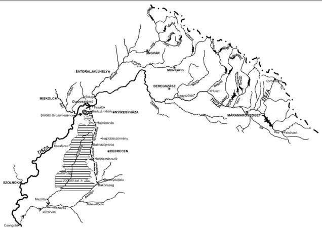
The basic idea was that the large reservoirs and hydroelectric power plants should be constructed within the changed north-eastern state borders, and these objects could be used for the regulation of the water budget of the Tisza River (Fig. 4). Mountain reservoirs and hydroelectric power plants can only be economical if they serve several purposes at the same time. Energetics use in itself cannot be profitable.
The plans included a 95-100 metres high dam that could have reserved a total amount of 1 billion m3 of water, which would have made the reservoir in the Visó Valley the 15th largest reservoir in the world and one of the largest ones in Europe. (The foundations of the concept were laid by József Benedek, the project was followed after his death by his son, Pál and Emil Mosonyi.)
The increase of military production led to new demands for energy. From the 1940s on, several government programmes stated the need for the increase of energy production on the basis of hydroelectric power plants.
Neither the top ministry of the economy nor the government defined directly the exact locations of the power plants; they gave energy and water management sector ample space of action. In connection with these programmes, Pál Benedek, leader of the Hydropower Office said that “... the connection of utilising hydropower with other uses of the water is an economic necessity”, so the utilisation of hydropower must be integrated with the demands of irrigation, navigation and flood protection [5].
Fig. 4. Plan of the Tisza irrigation system and the mountain reservoirs suitable for the storage of water, 1944 Notes. Ed. Mosonyi, Emil, 1944.
At the end of World War II, the geographer Gyula Prinz raised again the need for a new kind of cooperation for the utilisation of the hydro-energy in the Lower Danube River reaches: “The Lower Danube is the largest source of hydro-energy in Southeast Europe where the joint efforts of four nations could create an excellent flourishing”
[48].
This extremely short period is important for us inasmuch as in the shade of war threat and then in the time of the world war both the government and the academic sector made efforts for the utilisation of the regained territories and the integration of the new state territory.
HYDROELECTRIC POWER PLANT POLICY IN THE STATE SOCIALIST PERIOD (1949-1990)
After 1945 the focus of the professional efforts was reconstruction, but both theoretical and planning works related to the use of hydro-energy continued [39; 40; 41; 42, 43]. The work of the hydrologists was pursued within changed conditions and state borders, but their interwar activity was almost directly transferred to the new plans and concepts.
After the world war the most prominent persons of Hungarian geography insisted on the previous value system of geography and the use of the environment. Béla Bulla and Tibor Mendöl, examining the geography of the Carpathian Basin came to the conclusion in 1947 that “The image of the geographical distribution of hydropower, together with so many other factors, highlights the geographical unity of the Carpathian Basin”. The economy of the mountain edges could not do anything with this energy. After the utilisation of the hydropower potentials of the Carpathian Basin, the region could even export electrical energy [8]. For Hungarian geographical science, even after World War II the primary value was cultural landscape created from the original landscape, and the humanised artificial landscape.
The theoretical hydropower assets of Hungary – at 50% average water discharge – were estimated to be 7.2 billion kilowatt hour in the late 1940s. Of the total hydro-energy potential, 70% (5 billion kilowatt hour) was from the Danube River. The potential of the Hungarian-Czechoslovak border section was considered in a fifty-fifty per cent proportion.
For hydro-energy utilisation purposes the Danube River was divided into two sections: from the state border until Szob and from Szob down to Darázs. Already then it was clear for everybody that the section making the state border and the section in the Hungarian territory required different approaches. On the Hungarian section the possible location of the first hydroelectric power plant was at the Visegrád – Dömös – Zebegény reaches. In the Szentendre Danube branch Emil Mosonyi calculated with the construction of one power plant or two. Also, one hydroelectric power plant (at Paks), maybe two (with one more at Fajsz) between Budapest and the state border were considered possible by Mosonyi.
There were 4 alternatives for the common Hungarian-Czechoslovak Danube section:
1) one power plant or two in the bed of the main river branch;
2) several smaller hydroelectric power plants on the bypass canal to be built on the Czechoslovak side, with one large hydroelectric power plant around Bratislava, while the navigable bypass canal would run across the Csallóköz (Žitný ostrov) area;
3) a bypass canal to be built on the Hungarian side, using the Moson Danube branch;
4) bypass canals to be built on both sides, with divided navigation.
During the Hungarian researches and in the plan concepts, all possible solutions for the energetics use of the common Hungarian-Czechoslovak Danube section were defined before 1948, already.
In the year of 1949, the preparatory works of the power plant around Visegrád were accelerated (sediment measurements, fluid dynamics examinations etc.). During the preparations not only the experiences of the Soviet Union were evaluated but also a special attention was paid to the research of the sediment issues at the hydroelectric power plant called Kachlet, built on the Danube River. (In the first major Danubian hydroelectric power plant, in 20 years 5 million m3 of mud and 500 thousand m3 of gravel accumulated). In 1951 the Hydroelectric Power Plant Planning Office sped up the works.
The academic session held in 1951 was a professional summary of the hydroelectric power plant planning concepts made for the Danube and Tisza Rivers in the first years of state socialism. The Soviet practice and the power plant construction policy and practice of the neighbour states (Czechoslovakia, Romania) were important issues on the agenda.
The starting point was that “the power plants to be built on the Danube and Tisza Rivers are the most important part of the nature transforming works of Hungary” [67]. With the three power plants planned on the Tisza (at Tiszalök, Tiszabő and Szeged), 350 thousand hectares of land could be irrigated. The most important definition concerning the Danube River was as follows: “The Danubian dams will be built for energy production in the first place, but the aspects of navigation and irrigation must not be neglected here, either” [67]. Also, the Danubian hydroelectric power plants resulted in the saving of a considerable amount of coal for Hungary.
According to the concept worked out, the power plant would have been used for navigation, flood protection and electrical energy production at the same time. In 1951 the political leadership – Ernő Gerő – declared that the development of hydroelectric power plants along the Bratislava-Budapest Danube River section was not justified, as the coal-heated power plants produced the necessary energy at a lower cost.
On the initiative of the Hungarian Academy of Sciences, the Council of Ministers started in 1952 the elaboration of the National Water Management Framework Plan. The first draft of the Plan was discussed by the HAS in its general assembly. The Plan defined the correct order of the interventions systematically built on each other.
The often dreamed and planned Danube-Tisza Canal was given a new content. Until then the canal imagined in the different concepts would have served the needs of irrigation and transportation. Gyula Jolánkai named the planned canal the “Hungarian Lenin Canal” and committed himself to the plans of a high-capacity power plant also functioning as a peak power plant [20].
The implementation of the hydroelectric power plant at Tiszalök (in May 1954) primarily served irrigation purposes, it was only given a subordinate role in energy production (The construction of the dam at Tiszalök represented continuity in the history of hydroengineering in Hungary.)
Researches of the Danube River were not finished, in fact, a new dimension opened up for them after 1956. With the contribution of the Soviet Gidroprojekt Company, the plans for the complex use of the Hungarian- Czechoslovak section were made, including the draft plan of a hydroelectric power plant. In 1961 the Standing Committee of Electrical Energetics of the COMECON recommended in its statement the implementation of the energetics plans.
In 1961-1971 a kind of “reluctant enthusiasm” could be seen in relation with the Danubian power plants, the plans were continuously revised and amendments of the concepts were made. After 1973 the utilisation for energy production was in the focus, as the energy crisis became a dominant motivation. After 1973 confidential government decisions approved of the issues related to the preparation of the investment.
On the Tisza River, the Kisköre reservoir and power plant were opened in 1973. The filling up of the reservoir with water was done hastily, not all the forests had been removed from the area to be flooded.
The Hungarian hydroelectric power plant construction plans were realised, or reconsidered for the Danube River, when the environmental problems of the plain land power plants became visible both in the Soviet Union and other countries. The environmental attitude of international, later also of the Hungarian academic sector and their value system related to the use of the environment fundamentally changed. Without these important changes it is impossible to understand either the scientific or environmental-environmental protection, or the political processes of the later times.
The interstate agreement signed on 16 September 1977 practically closed the former processes and the implementation of the Gabčikovo-Nagymaros hydroelectric power plant system was launched, in many respects forced on an inescapable path. The interstate agreement set 1990 as the deadline for the completion.
The political environment of the investment was rather complex right from the 1950s. The interests and expectations of the moment often had a strong impact on the planning process and also on the construction plans. However, the scientific environment of the investment is even more complex. It was basically supported from the beginning both by water management and energetics, and some representatives of the science of geography also committed themselves many times to the construction of the power plant.
International and Hungarian environmental thinking gradually changed, environmentalist approaches came in the foreground and became dominant, to some extent due to political reasons [55]. Within environmental approach, water protection was now in the foreground, covering both surface and subsurface waters.
The issue of economicalness appeared in connection with the Gabčikovo-Nagymaros Hydroelectric Power Plant, but never in a full-range environment management approach. (Economicalness was always debated, from the 1920s on. It was often stated that economicalness must be seen in a wide approach; not only in the field of energy production but also taking its transportation, water protection, irrigation etc. correlations and components into consideration.)
The gradually unfurling crisis of the Hungarian economy, the decrease of demands for energy made the construction of the power plant unnecessary. The big question after 1978 was whether demands in other sectors (navigation, flood protection etc.) were important enough for the continuation of the investment.
The construction had delays because of the emerging economic problems; the deadline specified in the treaty was also amended in 1983, but in the fist half of the 1980s more and more initiatives were made that supported the further postponing or eventually the stop of the construction. Such initiatives were the declaration of the Hungarian Academy of Sciences in 1983 and the foundation of the non-governmental organisation called Duna Kör (Danubian Circle). The political issues of the period around the systemic change were integrated with the issue of the construction of the hydroelectric power plant. The power plant almost became a symbol of the power to be removed, and the movement claiming the stop of the construction became stronger and stronger.
Accordingly, the Hungarian government suspended the construction, and then the Parliament made a decision on the complete abandonment of the project.
Czechoslovakia was committed to the realisation of the construction, even at the price of realising the power plant by the construction of a smaller reservoir on the Czechoslovak side and the short inland section of the Danube River, diverting the water (which was the so-called variant “C”). The government of Czechoslovakia decided on the construction of their own version in late 1991 and the implementation took place as soon as in 1992. On 25 October the water of the Danube River was diverted at Čunovo (Dunacsúny in Hungarian) (1851.75 river kilometres), in an almost 40 kilometre section, to the artificial riverbed built on the Czechoslovak territory (bypass canal). The river only returns to the original bed at Sap (Szap in Hungarian). The larger part of the water of the Danube at this section still flows in the new riverbed; this share was 80–90% in the beginning. In the autumn of 1992 the two states turned to the International Court of Justice in Hague. A temporary agreement was made in Budapest in 1995 on the division of water, according to which Slovakia (as a successor state after the disintegration of Czechoslovakia and the legal successor of the treaties and the problem) was obliged to let a minimum of 400 cubic metres of water per second into the original (joint) riverbed. This amount is only a fraction of the original water discharge (1,500 cubic metres per second), not to mention the fact that the amount of water received by Hungary was an average amount, so even less was released to Hungary when the water discharge of the river was low. This caused serious environmental and natural damages on the Hungarian side in the Szigetköz, against which Hungary protected with temporary flow control methods.
The International Court of Justice in Hague in their decision of 1997 condemned both countries; according to its viewpoint both states had violated law. The judgement says the following:
“Hungary’s main argument for invoking a material breach of the Treaty was the construction and putting into operation of Variant C. As the Court has found in paragraph 79 above, Czechoslovakia violated the Treaty only when it diverted the waters of the Danube into the bypass canal in October 1992. In constructing the works which would lead to the putting into operation of Variant C, Czechoslovakia did not act unlawfully.
In the Court’s view, therefore, the notification of termination by Hungary on 19 May 1992 was premature. No breach of the Treaty by Czechoslovakia had yet taken place and consequently Hungary was not entitled to invoke any such breach of the Treaty as a ground for terminating it when it did.” (Judgement of the International Court of Justice, 25 September 1997, par. 108). The Court obliged parties to continue negotiations, which are actually still going on with varied intensity.
Nevertheless the over-politicisation of the issue in the past twenty years blocked any comprehensive decision or even the preparation of a decision concerning the utilisation of the hydropower and the navigability of the Danube River. The issue was pushed aside not by nature or environment protection motivations; it was much more the political risk that prevents concerned experts from discussing the issue in a clear and comprehensive way. The lack of a clear-cut concept, on the other hand, does not favour the improvement of either environmental or water management situation of Hungary. Our study demonstrated what clear ideas Hungary had in the past concerning the management of waters. Times change, it is evident that we do not want to see the applications of the past concepts in the present, but we should see similarly comprehensive frameworks of joint thinking.
REFERENCES
1. BÁNKI (D.), 1918 - A Vaskapu-vízierőmű tervezete [“Draft of the hydroelectric power plant on the Iron Gate”]. I-II. Budapest.
[in Hungarian]
2. BÁTKY (Zs.), KOGUTOWICZ (K.) (eds.), 1921 - Kogutowicz zsebatlasza az 1922. évre [“Kogutowicz’s pocket atlas for the year 1922”]. Magyar Néprajzi Társaság Emberföldrajzi Szakosztálya (Society of Hungarian Ethnographers, Human Geography Section). Budapest. [in Hungarian]
3. BENEDEK (J.), 1919 - A soroksári Dunaág vízerőtelepeinek előzetes üzemterve [“Preliminary operational plan of the hydroelectric power plants on the Soroksár Danube branch”]. Budapest [in Hungarian]
4. BENEDEK (J.), KANDÓ (K.), VICZIÁN (E.), 1920 - Magyarország vízienergetikai potenciálja [“Hydro-energy potential of Hungary”]. Map. Magy. Kir. Földművelésügyi Minisztérium Országos Vízépítési Igazgatósága. Budapest [in Hungarian]
5. BENEDEK (P.), 1942a - Vízierőink tervszerű kihasználásának energiagazdasági vonatkozásai [“Energetics relevances of the systematic utilisation of the hydropowers of Hungary”]. IN: Feyér Gy. (ed.) i. m. pp. 76 - 84. [in Hungarian]
6. BENEDEK (P.) 1942b - Hegyvidéki nagyobb vízierőink, különös tekintettel a tározásra [“Major mountain hydropowers in Hungary, with special regard to reservoirs”]. IN: A Mérnöki Továbbképző Intézet Kiadványai. Vol. I., book 3. Budapest.
[in Hungarian]
7. BOGDÁNFY (Ö.), 1914 - A vizierő I-II. Mérnöki kézikönyv [“Hydropower I-II. Engineers’ handbook”]. Magyar Mérnök és Építész-Egylet. Budapest. [in Hungarian]
8. BULLA (B.), MENDÖL (T.) 1947: A Kárpát-medence földrajza [“Geography of the Carpathian Basin”]. Printed by Egyetemi Nyomda. Budapest. [in Hungarian]
9. CHOLNOKY (J.) (ed.), 1920-1921 - A magyar béketárgyalások [“The Hungarian peace talks”], vol. I – IV. Magy. Kir.
Külügyminisztérium. Budapest. [in Hungarian]
10. EDVI ILLÉS (A.), HALÁSZ (A.), 1921 - Magyarország gazdasági térképekben [“Hungary in economic maps”]. Printed by Pallas nyomda. Budapest. [in Hungarian]
11. FEYÉR (Gy.), no year indicated - Energiagazdálkodás [“Energy management”]. IN: Közgazdasági enciklopédia, pp. 80 - 99.
Edit. Athenaeum. Budapest. [in Hungarian]
12. FEYÉR (Gy.) (ed.), 1942 - A magyar gazdasági élet műszaki teendői [“Technical tasks of the Hungarian economic life”].
Presentations held on the 75th anniversary session of the Hungarian Engineers and Architects Society. Edit. Centrum Kiadó. Budapest. [in Hungarian]
13. FODOR (F.), 1924 - Magyarország gazdasági földrajza [“Economic geography of Hungary”]. Printed by Franklin-Társulat.
Budapest. [in Hungarian]
14. HALÁSZ (A.), 1928 - New Central Europe in economical maps. Printed by Gergely. Budapest. [in Hungarian]
15. HALMOS (L.), 1952 - Törpe vízerőtelepeink [“Small hydroelectric power plant in Hungary”]. IN: Magyar Technika, vol. 7, No.
5. pp. 242 - 246. [in Hungarian]
16. HAVAS (H.) (ed.), 1988 - Bős-Nagymaros-dosszié [“The Gabčikovo-Nagymaros files”]. Printed by Codex Rt. Budapest. [in Hungarian]
17. HOCK (K.), 1948 - Vízierőink gazdaságossága [“Economicalness of the hydropower of Hungary”]. IN: Vízügyi Közlemények, vol. XXX, No. 2, pp. 188 - 200. [in Hungarian]
18. INTZE (O.), 1910 - A völgyzáró gátak történeti fejlődése, czélja és építése [“Historical development, objectives and construction of dams”]. IN: Vízügyi Közlemények, book XXVII, pp. 21 - 80. [in Hungarian]
19. JANKÓ-BREZOVAY (M.), 1939: Máramaros és Ugocsa vármegyékben építhető vizierő telepek [“Potential hydroelectric power plants in Máramaros and Ugocsa counties”]. IN: Vizügyi Közlemények, vol. XXI, No. 3 – 4, pp. 341 - 364. [in Hungarian]
20. JOLÁNKAI (Gy.), 1953 - Duna-tiszaközi hajózható, öntöző és vízierőtermelő főcsatorna [“The Duna-Tisza Canal for navigation, irrigation and hydropower production”]. IN: Vízügyi Közlemények , s. II, pp. 187 - 199. [in Hungarian]
21. KAFFKA (P.), 1933 - Az országrendezés mérnöki megvilágításban [“Physical planning in Hungary as seen by an engineer”].
IN: Magyar Szemle, vol. 188 (No. 71), pp. 209 - 217. [in Hungarian]
22. KAPOLYI (L.), 1997 - Bős-Nagymaros (Gabčikovo-Nagymaros). 1977. IN: História, vol. XIX, No. 9 – 10, pp. 38 - 44. [in Hungarian]
23. KERTAI (E.), 1949 - A Tisza-csatornázás hidrológiai előmunkálatai [“Hydrological founding works of the canalisation of the Tisza River”]. IN: Vízügyi Közlemények, No. 1 – 2, pp. 9 - 29. [in Hungarian]
24. KERTAI (E.), 1953a - Népi demokráciák vizerőhasznosítása [“Utilisation of hydropower in people’s democracies”]. IN:
Magyar Technika, vol. 8, No. 3, pp. 67 - 73. [in Hungarian]
25. KERTAI (E.), 1953b - A vizerőhasznosítás jelentősége Magyarország energiaellátásában [“The significance of the utilisation of hydropower in the energy supply of Hungary”]. IN: Magyar Technika, vol. 8, No. 10 – 11, pp. 622 - 627. [in Hungarian]
26. KOVRIG (B.), no year indicated - Vízierők [“Hydropowers”]. IN: Közgazdasági enciklopédia, vol. IV, page 1465. Edit.
Athenaeum. Budapest. [in Hungarian]
27. KVASSAY (J.), 1915 - Kimutatás az engedélyezett és előkészített vízi munkálatokról [“A report on the permitted and prepared water management works”]. IN: Vízügyi Közlemények, vol. V, No. 6, pp. 217 - 226. [in Hungarian]
28. KVASSAY (J.), 1917 - Vízgazdasági politikánk [“Water management policy in Hungary”]. IN: Vízügyi Közlemények, vol. VII, No. 9 – 6, pp. 261 - 267. [in Hungarian]
29. KVASSAY (J.) 1932 - Magyarország vízgazdasági politikája [“Water management policy of Hungary”]. IN: Vízügyi Közlemények, vol. XIV (January – June), pp. 127 - 136. [in Hungarian]
30. LÁSZLÓFFY (W.), 1948 - Magyarország vízgazdálkodása [“Water management in Hungary”]. IN: Földrajzi Zsebkönyv, pp.
60-71. Edit. Magyar Földrajzi Társaság. Budapest. [in Hungarian]
31. LAMPL (H.), MOSONYI (E.), 1954 - Vízépítési munkálataink fejlődése [“Development of the hydrological constructions in Hungary”]. IN: Vízügyi Közlemények, vol. 4, pp. 373 - 404. [in Hungarian]
32. LENCSÉS (G.), 1994 - A BNV építésének társadalmi keretben értelmezett története [“A history of the construction of the Bős-Gabčikovo Hydroelectric Power Plant, interpreted in a social framework”]. IN: Valóság, vol. XXXVII, No. 7, pp. 1 - 14. [in Hungarian]
33. MAGYARY (Z.), 1941 - A német országrendezés. IN: Közigazgatástudomány, vol. 4, No. 6, pp. 209 - 214. [in Hungarian]
34. MARKOS (Gy.), 1952 - A Szovjetunió természetátalakító tervei az ötödik ötéves terv távlatában [“Nature transformation plans of the Soviet Union in the fifth five-year plan”]. IN: Magyar Technika, vol. 7, No. 10 – 11, pp. 599 - 600. [in Hungarian]
35. MÁRTON (L.), 1953 - Törpe vízerőhasznosításunk egyes kérdései [“Issues of the use of small hydroelectric power plants in Hungary”]. IN: Magyar Technika, vol. 8, No. 1, pp. 9 - 14. [in Hungarian]
36. MOLDOVA (Gy.), 1998 - Ég a Duna! [“Danube on fire!”]. Edit. Kertek 2000. Budapest. [in Hungarian]
37. MOSONYI (E.), 1943 - A hegyvidéki víztározás jelentősége a Tiszavölgy öntözéses gazdálkodásában [“The importance of mountain reservoirs in the irrigated agriculture of the Tisza valley”]. IN: Magy. Kir. Vízierőügyi Hivatal Közleményei, No. 1. Printed by Stádium Sajtóvállalat Rt. Budapest. [in Hungarian]
38. MOSONYI (E.), 1944 - A visóvölgyi víztározó medence [“The reservoir of the Visó Valley”]. IN: A Magy. Kir. Vízierőügyi Hivatal Közleményei, No. 2. Printed by Stádium Sajtóvállalat Rt. Budapest. [in Hungarian]
39. MOSONYI (E.), 1946a - Az elméleti vízerőkészlet értelmezése és meghatározásának jelentősége az energiagazdálkodás szempontjából [“Interpretation of the theoretical hydropower assets and the significance of its measurement for energy management”]. IN: Klny. (supplement of) Magyar Technika, vol. I, No. 2. [in Hungarian]
40. MOSONYI (E.), 1946b - Magyarország elméleti vízerőkészlete [“Theoretical hydropower assets in Hungary”]. IN: Klny.
(supplement of) Magyar Technika, vol. I, No. 5. [in Hungarian]
41. MOSONYI (E.), 1947 - Vízerőművek létesítésének kérdése az országos villamosítás keretében. Hazai vízerőművek kiépítése [“The issue of the construction of hydroelectric power plants in the framework of the electrification of Hungary”]. IN: Klny. (supplement of) Magyar Technika, vol. II, No. 3. [in Hungarian]
42. MOSONYI (E.), 1948 - Magyarország vízierői [“Hydropowers in Hungary”]. IN: Vízügyi Közlemények, vol. XXX, No. 2, pp.
160 - 187. [in Hungarian]
43. MOSONYI (E.), 1949 - Kisesésű vízerőművek [“Small-scale hydroelectric power plants”]. Edit. Mérnöki Továbbképző Intézet Kiadása. Budapest. [in Hungarian]
44. MOSONYI (E.) 1951 - Vízerőhasznosítás [“The use of hydropower”]. Manuscript. VKM I. sz. Edit. Jegyzetsokszorosító Iroda Kiadása. Budapest. [in Hungarian]
45. MOSONYI (E.), 1952 - Korszerű folyami vízierőműek [“Modern hydroelectric power plants on rivers”]. Közoktatási Jegyzetellátó. Budapest. [in Hungarian]
46. MOSONYI (E.), 1955 - Az országos vízgazdálkodás fejlesztésének lehetőségei [“Possibilities for the development of water management in Hungary”]. Manuscript. Mérnöki Továbbképző Intézet. Budapest. [in Hungarian]
47. PATAKI (B.), 1942 - Víziutaink jelentősége a közlekedés szolgálatában [“The significance of the Hungarian waterways in transportation”]. IN: Feyér Gy. (ed.) 1942, pp. 64 - 75. [in Hungarian]
48. PRINZ (Gy.), 1944 - Magyarország földrajza [“The geography of Hungary”]. Edit. Renaissance Könyvkiadóvállalat.
Budapest. [in Hungarian]
49. PRINZ (Gy.), TELEKI (R.), CHOLNOKY (J.), no year indicated - Magyar földrajz II [“Hungarian geography II”). Printed by Kir.
Magy. Egyetemi Nyomda. Budapest. [in Hungarian]
50. RADISICS (E.) (ed.), 1946 - A Dunatáj I-III. Történelmi, gazdasági és földrajzí adatok a Dunatáj államainak életéből [“The Danube region I-III. Historical, economic and geographical data of the states of the Danube region”]. Printed by Gergely R. Rt. Budapest. [in Hungarian]
51. ROHRINGER (S.), 1923 - Vízgazdasági politikánk [“Our water management policy”]). IN: Vízügyi Közlemények, vol. IX, No.
2, pp. 3 - 9. [in Hungarian]
52. SAJÓ (E.), 1908 - Víziutak és vasutak hazánkban és a külföldön [“Waterways and railway in Hungary and abroad”]. IN: A Magyar Hajózási Egyesület Kiadványai, Új sorozat, No. 2. Printed by Athenaeum Irodalmi és Nyomdai Rt. Budapest.
[in Hungarian]
53. SAJÓ (E.), 1931 - Emlékirat vizeink fokozottabb kihasználása és újabb vízügyi politikánk megállapítása tárgyában [“Memoirs for the more intensive utilisation of the waters of Hungary and the definition of the country’s new water management policy”]. IN: Vízügyi Közlemények, vol. XIII, No. January – June, pp. 7 - 89. [in Hungarian]
54. SAJÓ (E.), BENEDEK (J.), 1911 - A Soroksári Dunaág felső kamrazsilipjének pályatervei és kiviteli terve [“Competition essay and implementation plan of the upper dam of the hydroelectric power plant on the Soroksár Danube branch”].
IN: Vízügyi Közlemények, No. 3, pp. 145 - 175. [in Hungarian]
55. SZABÓ (M.), 1985 - Zöldek, alternatívok, környezetvédők [“Greens, alternatives, environmentalists”]. Edit. Gondolat.
Budapest. [in Hungarian]