Melinda Koller
SETTLEMENT REMAINS IN THE NORTHERN PART OF COUNTY PEST (10
TH–13
THCENTURY AD)
This paper presents three settlement excavations from the Árpádian Age along the MOL gas pipeline in Pest County. Pilisvörösvár-Keréktanya site can be dated to the 10th–11th centuries. The other two sites, in the Zsámbék-Basin, are from the second half of the 12th and the first half of the 13th centuries. They have a farm-like character with a dispersed settlement structure. This is inferred by the relatively small number of features near the houses, which can be correlated to single households.
E tanulmány a MOL gázvezeték Pest megyei szakaszán feltárt három Árpád-kori lelőhely elemzése.
Pilisvörösvár-Keréktanya lelőhely a 10–11. századra, a Zsámbéki-medencében elhelyezkedő másik két lelőhely a 12. század második felére és a 13. század első felére keltezhető. Ezek tanyasi jellegű, szórt településszerkezetet mutatnak. Erre utal a házak közelében elhelyezkedő objektumok viszonylag csekély száma is, melyek egy-egy háztartásnak feleltethetőek meg.
Keywords: Árpádian dynasty period, village research, dispersed settlements, settlement structure, pithouse Kulcsszavak: Árpád kor, falukutatás, szórt települések, településszerkezet, veremház
Introduction
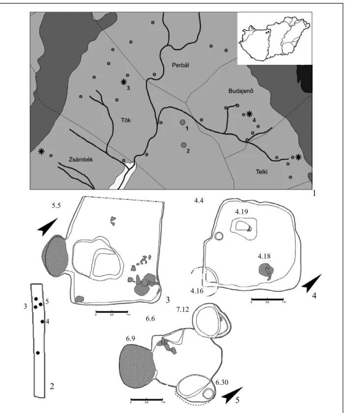
Prior to the laying of the MOL gas pipelines between Százhalombatta and Perbál, our team (comprising Viktória Kisjuhász, Máté Stibrányi and the author) conducted excavations at three Árpádian Age settlements (Fig. 1, 1) in November–December 2007, and February 2008. The sites of Pilisvörösvár- Keréktanya and Tök-Dézsér-táj were identified during field surveys conducted in the 1970s (MRT 7, 21/15 and 35/9 site ids.: MRT 7, 171–172, and 338).
During the archaeological excavations of the gas pipeline tracks in 2007, directly south of the latter, new archaeological features came to light, so the site was extended towards south. The third site, Tök- Alsó-Szarka-berek was identified ca. 600 m south of the previous one, during site inspections of the constructions, which were already underway in 2008.
The gas pipeline affected the sites in a 5 m wide track, thus, the excavations could only give a restricted view of the inner structure of the settlements.
Pilisvörösvár-Keréktanya site
The site can be found at the source region of the Háziréti-patak (stream), on its south-western banks,
north-west of the inner city areas of the town of Pilisvörösvár, in the Pilisvörösvár (Solymár) Basin surrounded by the stretches of the Pilis Mountains.
It can be identified as the medieval Kürt village mentioned in the perambulation texts of Csaba (Piliscsaba) in 1274 as a settlement lying south- east of it. The last data is known from 1429, when it was owned by György Pápai Nagy (MRT 7, 171–
172; GyöRffy 1998, 644). The gas pipeline crossed the western edge of the site. Eight archaeological features have been observed at a shallow depth in the extremely pebbly, reddish-brown subsoil, below a thin stratum of humus within the excavated area of 342 m² (Fig. 1, 2). The features were concentrated towards the stream. One pit could be dated to the 18th–19th centuries. It was located farther away from the rest of the features of the Árpádian Age and the watercourse, in the south- western part of the site.
The excavated features
The excavated buildings appeared in a group in the northern third of the site, closer to the watercourse.
m² building, on its south-western side dug deeply into the wall of the pit of the house. The foundation of its thin (ca. 1 cm thick), badly preserved, red burnt, baking surface was paved with river pebbles and broken stones at the level of the trodden surface of the house. Only the ca. 12 cm high base of the slightly burnt arch of the firing chamber remained. The elongated ashpit was in front of the mouth of the oven; it was dug into the trodden surface and deepened by steps towards the north (5/14, diam. 160×100, depth 6–26 cm). The fill at its bottom was loose, black and exceedingly rich in charcoal grains;
above it a red stratum was observed with lots of daub and larger charcoal pieces. The south-eastern half of the pit was covered with rubble consisting of large stone fragments at the level of the trodden surface, which also covered the eastern quarter of the building completely.
No postholes or other pits were found in the house.
The two buildings excavated at the site appeared in an extremely disturbed state. Although both are dwelling houses, they are of different types. In the case of building 4/4, it is possible that there could have been another posthole outside the house, in alignment with the excavated posthole; this, however, could not be examined due to the humus depot. There were no signs of any roofing structure or walls in the case of pithouse 5/5.
Open-air oven 6/6 (Fig. 1, 5) The oval-shaped, semi- subterranean oven (6/9, diam. 136×110 cm) stood ca. 60 cm north-east of building 5/5, at the northern part of the site. Its baking surface was slightly burnt through and preserved badly. The height of the burnt oven walls was 15 cm. Its black, extremely charcoal-rich fill with daub probably originated from the upper structure of the oven.
As there were no pottery sherds plastered into the baking surface, we can only date the oven based on the ceramics found in its foreground. The bottom of the amorphous rectangular workpit (6/10, diam. 220×175 cm) in front of its opening on the northern side was approximately at level with the bottom of the hearth; however, there was an 8 cm high and ca. 8 cm wide berm-like ridge between the mouth of the oven and the pit with a charcoaly layer along ca. 80 cm on the side towards the workpit. To the north-west of the mouth of the oven, next to the slanting side of the pit, we found several large stone fragments.
An oval deep pit or “niche” bulging outwards at its eastern side (6/30, diam. 120×80 cm) was dug into the north-eastern corner of the workpit. At its north-eastern end we excavated a rectangular depression (45 cm deep from the scraped surface, diam. 30x30 cm), which could be regarded as the location for the post supporting the roofing of the oven and its workpit. The north-western end of the working area was destroyed by a somewhat amorphous pit with a more or less circular basis (diam.
105×100, depth 40 cm) and a graded north-eastern wall (7/12); its distinctive patch appeared after scraping.
Feature 3/stratigraphical unit 3 (In the followings:
3/3). Only a small section of the feature, located on the south-western side of the site, was extended into the excavated area, thus, it was not excavated completely.
Based on its outlines, the 3 m long sidewall of a possibly dwelling house was unearthed.
Building (4/4) (Fig. 1, 4). It appeared to the south-east of feature 3/3. Its north-eastern side also extended outside of the excavated area, which we could only partially excavate. We could not reach its south-eastern corner because of the humus depot. The amorphous oblong-based building with rounded corners is oriented north-west / south-east; it deepens 28–33 cm into the stony subsoil; and apart from its south-eastern corner, it is 2,7×2,7 m large.
The sediment filling, the feature was rather pebbly-stony, brown, and mixed with charcoal specks and marly patches.
The remains of the hearth (3/18) appeared in the north- eastern half of the building, on the trodden surface level.
The black oven floor, the edges of which were unclear as they were removed, was probably round (39–40 cm in diameter). It was above a 2,5–3 cm thick, thoroughly well burnt, red daub layer. It had no foundation, only a shallow depression was formed for the plastering. It did not have an ashpit; a shallow, more or less oval patch with lots of charcoal appeared east of the baking surface. We have excavated the only posthole (4/29, diam. 23, depth 20 cm) in the central axis of the building, near the south-western sidewall. The principal post, holding the roof, was dug slantly into the ground; its fill was identical to the fill of the house. We have excavated a quarter of a shallow pit (4/16, its depth from the ground was 8 cm) in the south-eastern corner. A square-shaped pit (4/19) with rounded corners and graded bottom lay in the south-western quarter of the building.
A thoroughly burnt stone slab was found on the ground directly next to the baking surface in its north- eastern half. There were further larger slabs of stone on its top and lying around, at times burnt and soothed. As we could not find traces of clay plastering either between the stones, or around the hearth, this could be one of two types of firing structures: the stones were either intended to surround only the fireplace as lining, and it was open on the top, which means this would have been a stone fireplace (Takács 1993, 24); or a stone oven built without binding.
Building 5/5 (Fig. 1, 3). It was found north of building 4/4. Its north-western part also extended outside of the excavation borders; however, based on the section we observed, it probably had a rectangular base with rounded corners. Its orientation and fill was similar to those of house 4/4; its depth from the subsoil was 30–40 cm. There was an oven (5/7, diam. 110×60 cm), more or less oval, with its mouth towards the north, which was excavated near the southern corner of the near 12 1. kép 1: A Zsámbéki-medence északi része, Árpád-kori lelőhelyek (1. Tök-Dézsér-táj, 2. Tök-Alsó-Szarka-berek,
3. Tök-Rossztemplom, 4. Budajenő-Árpád-kori templom, csillag: templomok, kör: telepek); 2: Pilisvörösvár- Keréktanya, a feltárás felszínrajza; 3–5: Pilisvörösvár-Keréktanya, objektumrajzok
Fig. 1 1: Northern part of the Zsámbék Basin, Árpádian Age sites (1. Tök-Dézsér-táj, 2. Tök-Alsó-Szarka-berek, 3. Tök-Rossztemplom, 4. Budajenő-Árpádian Age church. Star: churches; Circle: settlements); 2: Pilisvörösvár-
Keréktanya, surface plan of the excavation; 3–5: Pilisvörösvár-Keréktanya, feature drawings
1
4
5 2
3 4
5 3
5.5 4.4
6.6 6.9
6.30
4.18 4.19
4.16 7.12
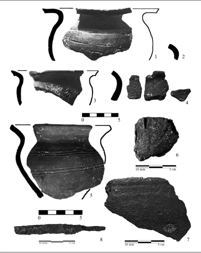
2. kép Pilisvörösvár-Keréktanya, leletanyag, 1, 3: 6/9 szabadban lévő kemencéből; 2, 6–8: 4/4 épületből;
4: 7/12 gödörből; 5: 4/16 gödörből
Fig. 2 Pilisvörösvár-Keréktanya, finds, 1, 3: from open-air oven 6/9; 2, 6–8: from building 4/4; 4: from pit 7/12;
5: from pit 4/16
1 2
3 4
5
6
7 8
0 5
0 5
Due to this disturbance, the possible structure of the open-air oven and workpit cannot be reconstructed. For the berm-like ridge János Gömöri (GöMöRi 2002, 185) made similar observations at Fertőszentmiklós in the case of the open-air oven 29/a at the Velux-ipartelep I site.
Ditch 2/2. We excavated a section of a widening, U-shaped, shallow (17–25 cm deep), 50–60 cm wide ditch oriented north-west–south-east, almost 10 m south of the buildings.
Based on its size and location, its function was probably to carry off water. István Méri (MéRi 1962, 213) mentioned ditches of similar function at the settlement of Kardoskút-Hatablak, where a layer of mud had settled at their bottoms.
The finds Ceramics
As is usual in the case of settlement remains, the majority of finds were made up of ceramics. No complete vessels from the Pilisvörösvár-Keréktanya site could be restored from the sherds, but we could discern that they mostly represent pots. Most of the ceramics were tempered with micaceous sand and a few small pebbles; in some cases with sand and grog;
and rarely with some sort of organic material as well.
The latter is indicated by pores with varying sizes on the surfaces. Two body sherds were tempered in a unique way. A dark grey body sherd (Id. no.
1.11213.4.28) was tempered with lots of calcareous inclusions, which consisted of broken shells (Fig. 2, 6). Another sherd (Id. no. 1.11203.4.12) was heavily tempered with graphite; a small amount of pebbles can also be seen in its tempering; its worn surface is decorated with a slightly incised horizontal line; its interior reveals that it was made on slow- wheel with slab technique (Fig. 2, 7). The precise dating of Austrian graphite-tempered imported ware is hindered by the fact that their chronology has not yet been set up at their production area, and not many of them are known from Hungarian publications. Apart from the towns along the Danube – such as Pozsony (Pressburg/Bratislava), Győr and Óbuda – they have been found at Gencsapáti-Besenyősziget in County Vas (kolleR
inpRinT) and at settlements of the Little Hungarian Plain: at Ógyalla-Bagotta and Mosonszentmiklós- Egyéni földek. Miklós Takács (Takács 1996, 186) explained their early appearances in these villages with the western exposure of the region of the Little Hungarian Plain. The early imported items in Hungary are all pots or large storage vessels.
Based on their associated finds, Takács (Takács 1996, 186) dated them to the 12th century, and
to the beginning of the 13th, although there were 10th–11th century ceramics next to the sherd from Győr-Káptalandomb (Takács 1996, 186; MeRva 2012, 12). In Gencsapáti-Besenyősziget, fragment of a large storage vessel was found. Because of its associated finds it can be dated to the 10th–11th century (kolleR in pRinT). The examples known from the area of Salvatorgasse, Vienna, are similar sherds of thick-walled vessels tempered with graphite. Sabine Felgenhauer-Schmiedt dated some of the pieces to the 10th–11th centuries (felGenhaueR-schMiedT 1982, 41–43).
The vessels are grey, brownish-grey, red, or light red and yellowish-brown; the predominance of the hand-forming technique can be observed on several sherds. The signs of this can be seen at the joining of vessel bases and sidewalls. The use of a slow-wheel is indicated by bottom stamps (Id. nos.
1.11203.4.4 and 1.11203.4.6 – their decorations are indiscernible as they are too fragmented) and the footring on the bases. The rims are simple: they are arched or horizontally outcurving; their ends mostly become thinner, rarely slightly thicker, and their edges are bevelled. The pot forms have wide mouths, short necks; their bodies are stockier or more globular; their shoulders and the upper third of the bodies are almost as wide as their mouths.
Their width is usually larger than their height, while the mouth widths can even exceed these, which is characteristic of 10th–11th century pots (Takács 1996, 156). Their most frequent ornaments are wavy line bands and line bundles, as well as the combination of these; single wavy and horizontal lines also occur; while densely incised vertical lines and small slant notches appear on two vessels.
Two sherds belong to table wares: one is a small cup (rim diam. 11 cm) fragment burnt to brownish- red, tempered with lots of sand and a smaller amount of larger grog pieces, with an exceedingly narrowing base and line bundle decoration (Fig. 2, 5). The other is a black, funnel-necked vessel of reduced firing, which has fine tempering; its form cannot be more precisely determined due to its fragmentariness (Fig. 2, 4). Its neck is decorated with small slant notches in three lines.
Metal find
The only iron object was a relatively long (7,8 cm), tanged, single-edged knife fragment from the fill of building 4/4. Its point had broken off, the blade was slightly arched (Id. no. 1.11203.4.37, Fig. 2, 8).
Based on the techniques, forms and ornamen- tation, the assemblage can be dated to the Early Árpádian Age, to the 10th–11th centuries.
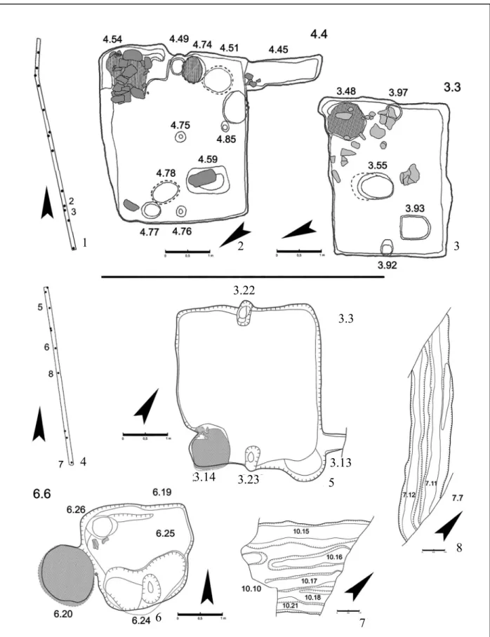
3. kép 1–3: Tök-Dézsér-táj, objektumrajzok; 4–7: Tök-Alsó-Szarka-berek, objektumrajzok Fig. 3 1–3: Tök-Dézsér-táj, feature drawings; 4–7: Tök-Alsó-Szarka-berek, feature drawings
1 2 3
4
5
6 7
8 3.3
3.13 3.14 3.23
3.22 Summary
The excavations lead us to deduce that the area of Kürt village, first mentioned in the 13th century, was already inhabited in the 10th–11th centuries.
Due to the character of the excavations, it is not possible to draw far-reaching conclusions about its structure and extent. Building 5/5 and the open-air oven 6/6 are too far away from one another to be called contemporary features. It is possible as well, that the pithouse had vertical wall. Their find material, however, does not show chronological variation, so it can be presumed that they were used for a shorter time in a narrower period, which is also suggested by the slightly burnt baking surface of the open-air oven. The consistent assemblage unearthed during the excavation asserts that this section of the site was inhabited in the Early Árpádian Period.
Tök-Dézsér-táj site
The site lies on the south-western banks of the Budajenő-patak (stream), at the north-eastern borders of Tök village, in the north-western part of the Zsámbék Basin extending between the Gerecse and Buda Mountains. The pipeline headed along the western edge of the site; a total of 1863 m² were excavated (Fig. 3, 1). Altogether 16 archaeological features appeared in dispersed groups.
The excavated features
During the excavation, two semi-subterranean buildings came to light, only 60 cm apart from each other, in the south-western part of the site farther away from the stream.
House 3/3 (Fig. 3, 3) The light yellow-brown patchy, tightly packed, plastered, trodden surface of the building appeared ca. 30 cm deep under the scraped surface; it is north-west / south-east oriented, with rounded corners and rectangular basis (dimensions: 380×240 cm). Its dark brown fill was mixed with yellow and sparsely contained larger daub pieces. The remains of its oven (3/48) appeared in its south-eastern corner. The extremely burnt sidewalls of the firing chamber cut into the wall of the building and the base of its arch were easily identifiable.
Several larger stone fragments were found on its baking surface, which was covered with a thick layer of rubble.
Its surroundings, as well as the fill of the house were most probably from the wall of the oven. The oven wall was built of mixed materials. There was a good quality, dark brown, round baking surface (diam. 74 cm) under
the rubble, with a surface slightly slanting towards south- west, towards the centre of the house. There were sherds plastered into its floor. A posthole was excavated at the centre of each shorter side of the building. The western one (3/92) was a rectangular posthole (diam. 22x22 cm) with rounded corners that was dug ca. 80 cm into the ground from below the trodden surface. We could observe that the soil, filled around it, was beaten after the post was set in its place. The principal post was also supported by the earth wall of the pithouse; its round indent in the wall was excavated. This was also observed in the case of the eastern posthole (3/97), but this was more rounded (diam. 30 cm) and went down to a depth of 58 cm. An oval pit (3/55) ca. 60 cm deep, 40×60 cm, bulging into a beehive shape on its northern side, was dug below the trodden surface in the centre of the house.
Its bottom slanted towards the north. A more or less square-shaped pit, 30 cm deep, with rounded corners and flat bottom, was excavated in the south-western corner of the building.
Pithouse 4/4 (Fig. 3, 2). The rectangular building with rounded corners was found north-east of House 3/3, 40–50 cm deep from the former walking surface. It is also oriented north-west / south-east, and is 380×330 cm large. After scraping, it appeared as a square-shaped patch on the surface; a long narrow extension could be seen on the western side of its southern corner (so called:
house with funnel). Its dimensions were, on the basis of the excavation record: length 180, width 60, depth 16–28 cm. The fill of the building was two-layered: light brown, mixed, clayey on the top; and brown, mixed with yellow, clayey with daub pieces on the bottom. Two larger postholes were found at the centre of each of the shorter sides, and in alignment with these, along the axis of the building, we found a smaller posthole. This structure was extended by another smaller posthole (4/85) at the centre of the south-western wall. The south-eastern principal post (4/49, diam. 20 cm) was half dug into the wall of the house; it was sunk 60 cm into the hard, plastered ground surface; the soil that was filled back into the hole after the post had been put in place was beaten down. The end of the similar sized north-western principal post (4/76) was pointed, as its diameter was only 10 cm at a depth of 60 cm. The diameter of the posthole at the centre of the house (4/75) was 10 cm, and it sunk ca. 20 cm deep into the ground. The oven of the building (4/54) was built in the north-eastern corner; only the base of its burnt walls remained against the western wall of the corner. Its baking surface (diam. 82 cm) was square-shaped, it had a mixed wall. The oven was surrounded by large stones;
several of these fragments could be excavated in situ.
There were carved stones among them, too. There were probably originated from the nearby Roman sites. Its floor had been renewed once. Below the former oven floor, in
4. kép Tök-Dézsér-táj, leletanyag. 1–2, 10: 4/4 épületből; 3: 5/5 árokból; 4: 4/95 kemence alapozásából;
5: 7/66 szabadtéri tüzelőhely gödrének betöltéséből; 6: 3/55 gödörből; 7–8: 3/3 épületből;
9: 4/74 padlóba mélyített tűzhelyből
Fig. 4 Tök-Dézsér-táj, finds. 1–2, 10: from pithouse 4/4; 3: from ditch 5/5; 4: from oven-base 4/95; 5: from firing pit fill 7/66; 6: from pit 3/55; 7–8: from house 3/3; 9: from the firing pit remains 4/74
1
2
3 4
5 6
7
8 9
10
0 5
0 5
0 5
0 5
0 5 the eastern side, there was a foundation from ceramic
sherds as well; its thickness (3–5 cm) was less at the back and appeared in a 52 cm wide patch. The second baking surface (5 cm thick) was covered by a large amount of rubble from its arch. The rubble was 6–7 cm thick in a radius about a metre. In front of its southern corner (between the extension and the oven) we observed two burnt patches (4/51 and 4/74). Following the excavation, feature 4/51 had a bulging wall (diam. 60×54, depth 40 cm), while feature 4/74 had a partly bulging wall (on its northern side). The latter (diam. 50×58 cm) was sunk ca.
15–20 cm into the ground; the sherds of a reconstructable pot were found in its southern half (Fig. 4, 9). Feature 4/51 was presumably the ash pit of another feature just north of it that can be interpreted as a firing pit, as its bottom joins with that of the other. We excavated another three depressions within the building; these lay along the north-western wall (4/59, 4/77, 4/78).
Similar pithouse and oven (building 2067.) are known from the village Kána (TeRei 2010. 91). As the two buildings happened to be too close to each other, they could not have been used concurrently; however, we cannot discern their exact chronology based on the finds, thus they both existed sometime in the 12th–13th centuries.
Ditches
The sections of four ditches (1/1, 5/5, 8/8 and 36/39) coincided with the excavation trenches. The orientation of ditches is north-west / south-east, and north-east / south-west; their form and dimensions (width 70–
100, depth 20–30 cm) are similar. Except for the first one, we could follow the curves of the other ditches surrounding rectangular areas. Due to the limited area of the excavation, their exact functions, e.g., plot borders or pens, could not be determined. From the point of view of the settlement structure, however, it is important that their orientation was identical to that of the buildings.
Open-air fireplace (2/2). We observed two features within an amorphous oval-shaped feature: a burnt area in its north-western part that can be interpreted as a firing pit, and an ash pit joining it from the south-east.
The feature was highly disturbed by agriculture, so its boundaries could not be exactly determined.
Burnt patch (34/37). The red, burnt patch (diam. 48 cm) was even more destroyed than the previous feature.
None of them can be dated by any finds. The rest of the features were shallow, small and mid-sized, partially disturbed pits. (The find material will be discussed below, together with the finds from the Tök-Alsó-Szarka-berek site.)
Tök-Alsó-Szarka-berek site
The settlement remains discovered during the construction works lay south of Tök-Dézsér-táj,
farther from the Budajenő-patak (stream), almost 700 m south-west of it. The route of the pipeline ran for about 200 m along the eastern part of the site – the size of which could be judged by the topographical characteristics of the area – where 10 archaeological features were excavated (Fig. 3, 4).
The excavated features
Pithouse 3/3 (Fig. 3, 5). We excavated the only building of the settlement section found in the northern half of the site. The pithouse had a rectangular basis with rounded corners and was oriented north-west / south- east; its beaten earth floor appeared 34–40 cm below the former walking surface. Beside the eastern corner of the 12 m² building, along the north-eastern long wall, 20 cm above the ground, an elongated extension (3/13, width 42 cm) could be observed. We do not know its total length, as its end extended over the edge of the excavation area. We managed to find the entrance of the house at the eastern corner. The corner was formed semicircularly (width 105 cm); it extended 30–34 cm from the surface of the wall, and it was graded. The first grade of the steps was 20 cm deeper than the one-time trodden surface; its second and lowest grade was uneven, slanting towards the interior of the building, and ca. 13 cm above the ground. The entrance probably became somewhat graded, or slanting due to use. The two postholes (3/22 and 3/23) were dug at the centres of the shorter walls. The two principals posts, partially sunk into the earth wall, were indicated by their beaten, square-shaped, yellowish-grey patches on the yellow ground. The fill of the posthole was identical to that of the house: a compact dark brown layer, mixed with yellow and containing calcareous concretions and daub pieces. The only difference appearing between the two principal posts was that while the north-western one (3/22, sank 58 cm into the ground) was more square- shaped (width: 25 cm), the south-eastern one (3/23, its depth from the ground was 59 cm) had a more circular basis (diam. 28 cm). The rectangular-based oven (3/14, diam. 100x100 cm) with arched walls was cut into the southern corner of the house. Its burnt sidewall could be followed up to the height of the sidewalls of the house. Its baking surface was preserved only fragmentarily. Several stone fragments and a brick lay in secondary position on its western side; and larger stones already appeared during the excavation that also indicated an oven built of different material. Its slightly arched, synclinal bottom was reached 32 cm from the floor of the oven.
Open-air oven 6/6 (Fig. 3, 6). It was situated ca.
40 m south of building 3/3 with a joining workpit. The slightly oval-based oven (6/20, dimensions 140×125 cm) was at the centre of the south-western side of the latter.
The burnt sidewalls remained standing at a height of 18 cm. Its baking surface was 3–4 cm thick, brownish-
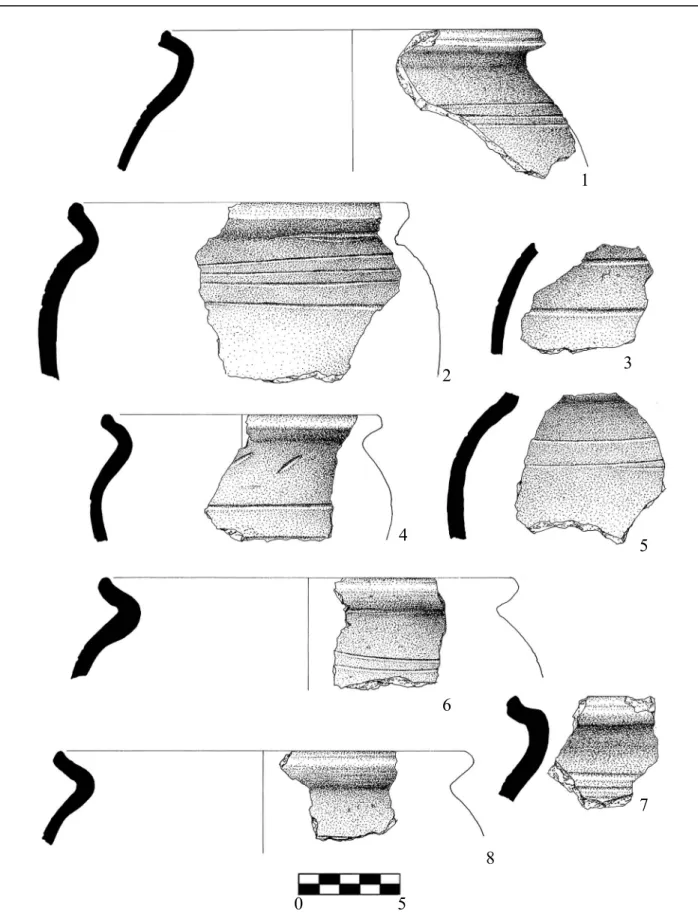
5. kép Tök-Alsó-Szarka-berek. 1–8: 3/3 épület leletanyaga Fig. 5 Tök-Alsó-Szarka-berek, finds. 1–8: from pithouse 3/3
1
2 3
4 5
6
7
8 0 5
red and was preserved in good condition. Its mouth opened towards the east; here the floor curves slightly downwards, towards the workpit. Below the 10 cm thick plastering, near the mouth, the section of a previous baking surface came to light, which was probably removed before renewal. The trapezoid working area with rounded corners started ca. 30 cm below the floor.
Two units could be discerned within it: north of the oven mouth there was a smaller beehive-shaped pit (6/26);
a kidney-shaped, uneven-based depression (6/24) was found next to the southern wall; its section closer to the oven could have been the ashpit. The northern wall was made to be gradient. The trodden surface (6/25) of the working area formed a hard surface at the centre.
Ditches We have excavated two ditch sections 100 m apart (Fig. 3, Fig. 7–8). The double ditch (7/7) ran from north-west to south-east, the orientation of the ditch system (10/10) with five sections was north-west / south-east. Although they did not contain any finds, due to the lack of dated features from other periods we can categorize them as belonging to the Árpád dynasty period settlement. The various diversions of each ditch were not contemporarily made, but they had been renewed several times. The ditches matched the orientation of the excavated building, just as in the case of the Tök-Dézsér- táj site.
The finds of Tök-Dézsér-táj and Tök-Alsó-Szarka- berek
The identifiable ceramic sherds were, typologically, pot fragments. Their majority were fired in an oxygen-rich atmosphere; they were greyish-white, yellowish-white, light grey, yellow, light red, light brown and white in colour; rarely red, orange, or reddish-brown. Only a very small percentage of the sherds were black or dark grey and grey, fired in reduced circumstances. Their tempering materials are sand and small, rarely larger gritty pebbles with rough surface. In one example limestone was used as a tempering material (Id. no. 1.11889.4.14).
It can be seen that the vessels were made on a slow-wheel with slab or coiling technique, which can be well observed on the uneven exteriors and interiors. The bases and the sidewalls were separately made, which is indicated by the joining of the interiors where the individual parts meet. The unevenness of the bases and the occasional occurrence of the imprint of the shaping wheel (Id. no. 1.11889.4.3) reveal the fact that the vessels were lifted off the wheels. The concentric bumps inside the vessels indicate their forming on wheel (Fig. 4, 7).
The outcurved rim shaped with a nail-head is the most frequent. There are others with arched and
everted, widening, articulated, as well as rounded rim edges. One of the rim fragments was damaged during manufacture: probably they had cut into the rim with a wide, flat tool from the outside whilst pulling it outwards (Fig. 4, 8). This damage can be considered as a kind of proof regarding the separate forming techniques for manufacture.
The decoration of the vessels consisted mainly of horizontal incisions and incised spirals at various intervals, while slant scratched decoration was also frequently applied. On several examples only the shoulder and belly of the vessels were decorated with two or three horizontal incisions (Fig. 4, 3, 9; Fig. 5, 1–2) similarly to what was observed at various contemporary settlements (ÍRásné Melis 2008, 149; Takács 1996, 165). The majority of the material is composed of slender bodied, short necked pots, which are the widest at the upper third of the vessel bodies. In contrast with other localities from the Árpádian period no clay cauldrons were found at these sites.
Among the iron artefacts a single-edged, tanged iron knife (Id. no. 1.11889.47.1, Fig. 4, 10) and a heavily corroded, long drill bit fragment can be mentioned (Id. no. 1.11889.3.9). Based on the analogies of the finds, they can be dated to the second half of the 12th and the first half of the 13th centuries.
This dating is confirmed by the fragment of silver denar of Géza II. (CNH I. 150, RéThy 1899, 24, 9 t.; huszáR 1979, 50; unGeR 1980, 24) from the floor of the building 3/3 in Tök-Alsó-Szarka-berek site.
Observations on settlement structure and settlement history of the two sites in the periphery of Tök The two sites excavated in the Zsámbék-Basin are similar both in their characteristics and settlement features. They have a farm-like character with a dispersed settlement structure. Similar settlement structures are known from more sites in County, (Rácz 2010, 71). This is inferred by the relatively small number of features near the houses, which are suitable for single households. The settlements must have been used for a short period of time; their arrangements were probably associated with the coexistent farming system of boundary territories.
The role of the ditches must also be connected to this system. The elongated ditches that had been renewed several times were probably borderline indicators of plots (MéRi 1962, 216); those that break in rectan- gular angles can also be interpreted as pens (Tök- Dézsér-táj, Ditch 5/5). Most likely, they did not have water draining functions, as their fills are unified without any layer of mud identifiable within them.
topográfiája 7. köt. Pest megye régészeti topográfiája XIII/1. köt. Budapest 1986.
MeRva 2012 MeRva sz., A kora Árpád-kori sáncvárak keltezési lehetőségeiről. Castrum 15 (2012) 5–31.
MéRi 1962 MéRi i., Áz árkok szerepe Árpád-kori falvainkban. – Angaben zur Siedlungsform der Arpadenzeitlichen ungarischen Dörfer. AÉ 89 (1962) 211–218.
Rácz 2010 Rácz T. Á., Árpád-kori települések szerkezetének sajátosságai Pest megyében.
Kutatások az M0-s autópálya és a 4-es számú elkerülő főút nyomvonalán. – Characteristics of the structure of Árpádian-Era settlements in Pest County.
Investigations along the line followed by the M0 motorway and the highway 4 bypass. In: Benkő E.–Kovács Gy. (szerk.), A középkor és a kora újkor régészete Magyarországon. Budapest 2010, 69–79.
RéThy 1899 RéThy L., Corpus Nummorum Hungariae. Magyar Egyetemes Éremtár I.
Budapest 1899.
Takács 1993 Takács M., Falusi lakóházak és egyéb építmények a Kisalföldön a 10–
16. században (Kutatási eredmények és további feladatok). – Dörfliche Wohnhäuser und sonstige Gebäude in der Kleinen Tiefebene vom 10. bis zum 16. Jahrhundert (Forschungsergebnisse und weitere Aufgaben). In: Perger Gy.–Cseri M. (szerk.), A Kisalföld népi építészete (A Győrött 1993. május 24–25-én megrendezett konferencia anyaga). Szentendre–Győr 1993, 7–53.
Takács 1996 Takács M., Formschatz und Chronologie der Keramik des 10–14.
Jahrhunderts der Kleinen Tiefebene. ActaArchHung 48 (1996),135–195.
Takács 2000 Takács M., Nucleated and/or dispersed settlements from the Árpádian and the Angevin age in the West Hungarian region of Kisalföld. Ruralia III.
Památky Archeologické – Supplementum 14, Prague 2000, 240–251.
TeRei 2010 TeRei Gy., Az Árpád-kori Kána falu. – Kána, a village from the Árpádian Era (Twelfth-Thirteenth Centuries). In: Benkő E.–Kovács Gy. (szerk.), A középkor és a kora újkor régészete Magyarországon. Budapest 2010, 81–
unGeR 1980 111.unGeR e., Magyar éremhatározó I. Budapest 1980.
ÁRPÁD-KORI TELEPüLÉSNYOMOK PEST MEGYE ÉSZAKI RÉSZÉN Kivonat
A MOL Százhalombatta-Perbál között tervezett gázvezeték fektetését megelőzően három Ár- pád-kori telepen (Pilisvörösvár-Keréktanya, Tök- Dézsér-táj I–II és Tök-Alsó-Szarka-berek) végez- tünk feltárást 2007 november-december folyamán, illetve 2008 februárjában. A gázvezeték nyomvo- nala mindössze 5 m szélességben érintette a lelő- helyeket, így az ásatások csupán korlátozott képet nyújtottak a telepek belső szerkezetéről.
A középkori Kürt faluval azonosítható Pilis- vörösvár-Keréktanya lelőhely nyugati szélén át- haladó vezeték nyomvonalán hét Árpád-kori ob- jektum került elő, melyek a Háziréti-patak felé sűrűsödtek. Az előkerült épületek (3. objektum/3.
stratigráfiai egység /a továbbiakban 3/3/ egy cso- portban, a feltárási terület vízfolyáshoz közelebbi,
északi harmadában helyezkedtek el. A feltárt te- rület északi részén, az 5/5 épülettől kb. 60 cm-rel északkeletre feküdt a 6/6 külső kemence, ezek a köztük lévő csekély távolság miatt nem állhattak egy időben. Az előkerült leletanyag azonban nem mutat időrendi különbséget köztük, ezek alapján egy szűkebb időszakban, rövid ideig lehettek hasz- nálatban, amire a szabadban álló kemence gyengén átégett sütőfelülete is utal, de fennáll az a lehető- ség is, hogy esetleg függőleges, felmenő falazat- tal rendelkezett az épület. Az ásatás során előke- rült egységes leletanyag alapján megállapítható, hogy a lelőhelynek ezt a részét a kora Árpád-kor- ban, a 10–11. században lakták.
A Zsámbéki-medence északnyugati részén, Tök északkeleti határában található másik két lelőhely, Although the narrow, 5 m wide excavation trench-
es do not allow us to draw definite conclusions, it can be observed at both settlement sections that the ditches are at equal distances from one another and the living quarters lay scattered between them, each unit consisting of a house, an open-air oven, a fire- place, and a few storage pits. Thus, according to our observations the ditches served as borders between the individual households. Similarly dispersed set- tlements are known from this period in the Great Hungarian Plain (laszlovszky 1986, 131–147) and in Western Transdanubia, e.g.: the sites of Hegye- shalom-Holdas szántók, Bezenye-Országútra-dűlő, Mosonszentmiklós-Horgas (Takács 2000, 244–
248) and Fertőszentmiklós-Velux (GöMöRi 2002, 181–185). According to János Gömöri (GöMöRi 2002, 185), the vast number of such farmstead settlements before the end of the 13th century is the result of crop rotation.
During the previous field survey (MRT 7) in the vicinity of our sites, several other Árpád dynasty period settlement remains had been known (Fig. 1, 1). South-east of Tök–Dézsér-táj, at a 600–700 m distance east of the confluence of the Budajenő and Békás-patak (stream), we can find the site Felső- Szarka-berek (MRT 7, 35/6 site id. nr., MRT 7, 338). Árpádian age settlement remains (Budajenő-
Paraszt-rétek, MRT 7, 2/5 site id. nr., MRT 7, 39–
40) are also known at the north-eastern side of the Budajenő-patak (stream), in front of the Dézsér-táj site. The connections of Tök-Dézsér-táj with the two sites mentioned above could only be cleared by further excavations; however, it is certain that they did not form a tight unit with the partially excavated Alsó-Szarka-berek site. Several Árpád dynasty period sites are also known near Budajenő, which is located in its original place even today. Its church, already existing in the 12th century, is still standing.
When studying the relationship of the above- mentioned sites, the questions of how loose a settlement structure could have been and how often a settlement could have changed its location were arising. The settlements on the north-eastern banks of the Budajenő-stream (MRT 7, 2/5 site id. nr., MRT 7, 39–40) and at Felső-Szarka-berek dűlő were dated to the 11th–12th centuries (MRT 7, 40 and 3338). Thus, they are somewhat earlier than the finds from our sites and could not have been contemporary, which may have been the result of former agricultural customs. The lifespan of the above settlements could only be ascertained by further excavations. Thus, it cannot be decided whether they had been part of a single settlement or were established in different times.
REFERENCES felGenhaueR–
schMiedT 1982 felGenhaueR–schMiedT, S., Herstellungsmethoden der mittelalterlichen Keramik. In: Ortolf, H. (Hrsg.), Keramische Bodenfunde aus Wien:
Mittelalter–Neuzeit. Wien 1982, 31–126.
GöMöRi 2002 GöMöRi J., Castrum Supron. Sopron vára az Árpád-korban. – Die Burg von Sopron (Ödenburg) und deren Umgebung in der Árpádenzeit. – The Castle of Sopron and its County int he Árpád-Age 11th–13th cent. A. D.). Sopron 2002.
GyöRffy 1998 GyöRffy Gy., Az Árpád-kori Magyarország történeti földrajza IV. Budapest 1998.
huszáR 1979 huszáR l., Münzkatalog Ungarn: Von 1000 bis heute. Budapest 1979.
ÍRásné Melis 2008 ÍRásné Melis k., Régészeti kutatások az M0 autópálya ÉK-i szakaszán elhelyezkedő 11–13. századi falu területén (Budapest, XV. Rákospalota- Újmajor I. lelőhely 1995). – Archäologische Forschungen auf dem Gebiet des bei der nordöstlichen Strecke der Autobahn M0 liegenden Dorfes aus dem 11–13. Jh. BudReg 41. (2008) 85–152.
kolleRinpRinT kolleR M., „Fazekat kongásán…”: a Vas megyei Besenyő falu Árpád-kori leletanyaga. In: Simonyi E. (szerk.), „A cserép igazat mond, ha helyette nem mi akarunk beszélni” – Regionalitás a középkori és kora újkori kerámiában.
Konferencia 2013. január 9–11. Opuscula Hungarica, kézirat.
laszlovszky 1986 laszlovszky J., Tanyaszerű települések az Árpád-korban. In: Novák L.–
Selmeczi L. (szerk.), Falvak, mezővárosok az Alföldön. – Villages, country towns in Great Hungarian Plain. – Dörfer, Marktflecken auf der Grossen Ungarischen Tiefebene. Nagykőrös 1986, 131–151.
MRT 7. Torma I. (szerk.), A budai és a szentendrei járás. Magyarország régészeti
Koller Melinda
Forster Gyula Nemzeti Örökségvédelmi ésVagyongazdálkodási Központ
H-1014, Budapest, Táncsics Mihály utca 1 melinda.koller@forsterkozpont.hu
Tök-Dézsér-táj I–II és Tök-Alsó-Szarka-berek, egy- mástól mintegy 700 m-re helyezkedett el. Jellegük- ben és településobjektumaikat tekintve is hasonlóak.
A feltárás tanúsága szerint egy lelőhelyként értelmezhető Tök-Dézsér-táj I–II lelőhelyen két, északnyugat-délkeleti tájolású, egymástól csupán 60 cm-re fekvő, félig földbe mélyített épület (3/3 és 4/4) került elő, a lelőhely pataktól távolabbi, dél- nyugati részén. A 4/4 ház úgynevezett nyeles ház.
Mindkettőben vegyes falazatú kemencét tártunk fel. Mivel a két épület túl közel volt egymáshoz (60 cm), nem használhatták őket egy időben, azonban a leletanyag alapján nem lehet köztük időrendi kü- lönbséget megállapítani, mindkettő a 12–13. szá- zadban létezett. A kutatószelvénybe négy árok (1/1, 5/5, 8/8, 36/39) részlete esett bele, az első kivéte- lével mindegyik esetében sikerült a négyszögletes területeket határoló árkok kanyarulatait is megfi- gyelni. A feltárás kis felülete miatt nem lehet pon- tosan megállapítani ezek telekhatároló vagy karám funkcióját, de a településszerkezet szempontjából fontos tény, hogy irányításuk megegyezik az épü- letek tájolásával. A gödrök mellett egy szabadtéri tüzelőhely (2/2) is előkerült a lelőhelyről, de ezt a mezőgazdasági művelés erősen roncsolta.
Tök-Alsó-Szarka-berek lelőhelyen egy észak- nyugat-délkeleti tájolású, félig földbe mélyített,
nyéllel rendelkező épületet (3/3) tártunk fel, mely- nek keleti sarkában a ház bejáratát is sikerült meg- figyelnünk. Négyzetes alaprajzú kemencéje szintén vegyes falazatú volt. Az épülettől délre helyezkedett el a 6/6 külső kemence a hozzá kapcsolódó munka- gödörrel. A feltárás területére két árokszakasz esett.
A 7/7 kettős árok, míg a 10/10 ötszörös, többszörö- sen megújított árokrendszer. A két jelenség kb. 100 m távolságra volt egymástól. Az árkok, hasonlóan a Tök-Dézsér-táj lelőhelyen megfigyeltekhez, illesz- kednek a feltárt épület tájolásához. Leletanyaguk a 12. század második és a 13. század első felére kel- tezhető. A keltezést a 3/3 épület padlójáról előkerült II. Géza denár töredék (CNH I. 150) is alátámasztja.
A két zsámbéki-medencei lelőhely tanyasi jelle- gű, szórt településszerkezetet mutat. Erre utal a há- zak közelében elhelyezkedő objektumok viszonylag csekély száma is, melyek egy-egy háztartás igénye- inek felelnek meg. A telepeket szűkebb időszakban használhatták, elrendezésük feltehetően az egykori határműveléssel függhet össze. Az árkok szerepét is ez a funkció magyarázza. Mindkét teleprészleten megfigyelhető volt, hogy az árkok hasonló távolság- ra vannak egymástól, ezek között van a lakóegység, mely az egymástól elszórtan elhelyezkedő házból, külső kemencéből vagy tüzelőhelyből, valamint ke- vés számú tárológödörből áll.