Dissertationes Archaeologicae
ex Instituto Archaeologico
Universitatis de Rolando Eötvös nominatae Ser. 3. No. 3.
Budapest 2015
Dissertationes Archaeologicae ex Instituto Archaeologico Universitatis de Rolando Eötvös nominatae
Ser. 3. No. 3.
Editor-in-chief:
Dávid Bartus Editorial board:
László Bartosiewicz László Borhy Zoltán Czajlik
István Feld Gábor Kalla
Pál Raczky Miklós Szabó Tivadar Vida Technical editors:
Dávid Bartus Gábor Váczi Dániel Szabó
Proofreading:
Szilvia Szöllősi Zsófia Kondé
Available online at http://dissarch.elte.hu Contact: dissarch@btk.elte.hu
© Eötvös Loránd University, Institute of Archaeological Sciences
Budapest 2015
Zoltán Czajlik 7 René Goguey (1921 – 2015). Pionnier de l’archéologie aérienne en France et en Hongrie
Articles
Péter Mali 9
Tumulus Period settlement of Hosszúhetény-Ormánd
Gábor Ilon 27
Cemetery of the late Tumulus – early Urnfield period at Balatonfűzfő, Hungary
Zoltán Czajlik – Balázs Holl 59
Zur topographische Forschung der Hügelgräberfelder in Ungarn
Zsolt Mráv – István A. Vida – József Géza Kiss 71
Constitution for the auxiliary units of an uncertain province issued 2 July (?) 133 on a new military diploma
Lajos Juhász 77
Bronze head with Suebian nodus from Aquincum
Kata Dévai 83
The secondary glass workshop in the civil town of Brigetio
Bence Simon 105
Roman settlement pattern and LCP modelling in ancient North-Eastern Pannonia (Hungary)
Bence Vágvölgyi 127
Quantitative and GIS-based archaeological analysis of the Late Roman rural settlement of Ács-Kovács-rétek
Lőrinc Timár 191
Barbarico more testudinata. The Roman image of Barbarian houses
Field reports
Zsolt Mester – Norbert Faragó – Attila Király 203
Report on the excavation at Páli-Dombok in 2015
Ágnes Király – Krisztián Tóth 213
Preliminary Report on the Middle Neolithic Well from Sajószentpéter (North-Eastern Hungary)
András Füzesi – Dávid Bartus – Kristóf Fülöp – Lajos Juhász – László Rupnik –
Zsuzsanna Siklósi – Gábor V. Szabó – Márton Szilágyi – Gábor Váczi 223 Preliminary report on the field surveys and excavations in the vicinity of Berettyóújfalu
Márton Szilágyi 241
Test excavations in the vicinity of Cserkeszőlő (Jász-Nagykun-Szolnok County, Hungary)
Dávid Bartus – László Borhy – Emese Számadó 245
Short report on the excavations in Brigetio in 2015
Dóra Hegyi 263
Short report on the excavations in the Castle of Sátoraljaújhely in 2015
Maxim Mordovin 269
New results of the excavations at the Saint James’ Pauline friary and at the Castle Čabraď
Thesis abstracts
Krisztina Hoppál 285
Contextualizing the comparative perceptions of Rome and China through written sources and archaeological data
Lajos Juhász 303
The iconography of the Roman province personifications and their role in the imperial propaganda
László Rupnik 309
Roman Age iron tools from Pannonia
Szabolcs Rosta 317
History of the settlement of the Sand Ridges of Kiskunság between the 13th–16th century
Late Roman rural settlement of Ács-Kovács-rétek
Bence Vágvölgyi
Hungarian Academy of Sciences Research Centre for the Humanities, Institute of Archaeology bence.vagvolgyi@gmail.com
Abstract
One of the biggest problems archaeologists face during interpretation is the fragmented and incomplete nature of the datasets often produced by field work. In most cases, the excavation of a whole site is not possible, and even the find material is so fragmented as to make their interpretation quite problematic. Such is the case of Ács-Kovács-rétek, a small Late Roman rural settlement, a part of which was excavated in 2009–2010. These excavations provided a very deep insight into the life of the village, but due to their limited scope, they still left a number of questions unanswered. For a more thorough interpretation of the site, we have to look at the find material and its spatial and chronological context from as many different angles as possible. Such analyses have to rely heavily on very detailed quantitative and GIS-based methods that can not only hold large amounts of very diverse information, but can also recombine this information for statistical and spatial analyses that can deepen our understanding of the site. The aim of this paper is to demonstrate the power of detailed quantitative databases and methods for site interpretation through the study of a Late Roman settlement, Ács-Kovács-rétek. During the course of this research a large number of attributes of the find material and the site itself were recorded in structured databases. Thanks to the rational structuring of this data, it could not only be statistically analyzed, but also compared to other sites as well, helping to solidify the timeframe in which the settlement was inhabited, and also uncovering several interesting patterns about its inhabitants. Furthermore, the combination of this data with spatial information even helped to recognize certain changes and spatial patterns within the settlement itself. By the end of my research, a clear picture emerged of this Late Roman village, showing a Romanized population living here from the end of the 3rd through the 4th century AD that not only had connections regionally, but also fit into a local rural landscape in the hinterlands of the Ripa Pannonica.
Introduction
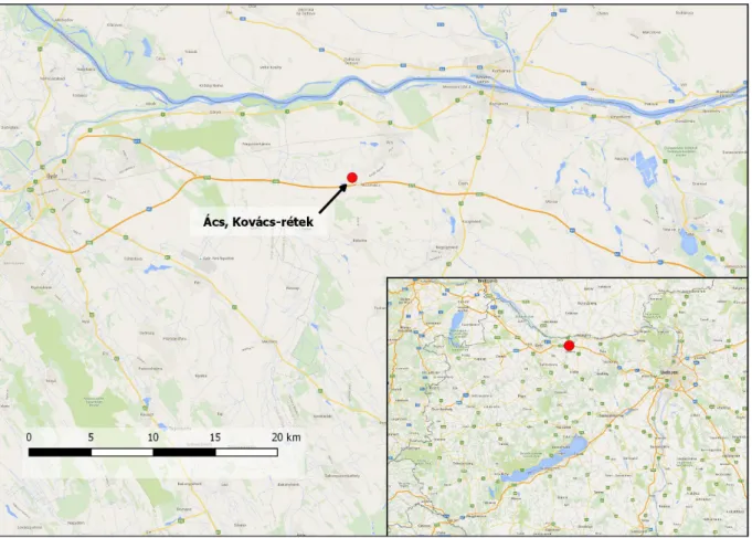
The site of Ács-Kovács-rétek lies in the western part of Komárom-Esztergom County in the northwestern part of Hungary,1approximately 7 kilometers south of the Danube river, and 15 kilometers southwest of the town of Komárom, wherein lies the ruins of the significant Roman town of Brigetio. It was here in 2009–2010 where during rescue excavations archaeologists came across the remains of a Late Roman rural settlement, which is the subject of this article.
As can be seen from the geographic location of the site, it lies in a relatively prominent part of Pannonia, right next to not only theRipa Pannonica, but a significant town (Brigetio) as well.
Despite being in the hinterlands of both of the above, there is not much known of this rural area due to a lack of research available. This adds extra importance to the site, but also an obligation
1 The exact coordinates of the site are: 47°41’10.45"N, 17°58’13.56"E.
to examine it as completely as possible, and to place it in a regional context, so as to learn more about this economically and logistically crucial part of the region. The complete understanding of the site was only possible through GIS- and data-based quantitative methods, of which I aimed to use as much as possible during my study which was conducted as part of my MA thesis at the Institute of Archaeological Sciences of the Eötvös Loránd University, Budapest.
1. Topography and research history of Ács-Kovács-rétek
In order to be able to interpret the finds and the structure of this complex, it is important to put it in context first. This means that we have to take a look at the research history of its surroundings to better grasp the earlier research made in the area. Then, using this information (combined with available information about the natural circumstances of the area) we shall attempt to reconstruct the natural and anthropogenic setting of Ács-Kovács-rétek. Doing so will mean that any observation made during the analysis of this village can be put into a wider perspective, and thus will help in the final interpretation of the site.
Fig. 1.The exact location of the site of Ács-Kovács-rétek.
1.1. Previous research in the vicinity of the site
The territory surrounding Ács was first mentioned in the archaeological literature by Flóris Rómer in 1863, when he wrote about ancient artifacts found in the vicinity of the village.2 However, the first excavations in the area were only carried out in 1948 by László Barkóczi,
2 Rómer 1863, 44.
who successfully identified the remains of a roman fort at Ács-Vaspuszta.3 From this point on there is relatively more information available, although most of it is unpublished, and can only be found in the archives. In 1952 there is a mention about carved stones found near the village, but their exact location is unknown.4In 1954, during the building of the village school, workers found several graves that belonged to the Roman era,5and in 1956 several carved stone pieces were found at Ács-Bumbumkút, which Lajos Dobroszláv dated to the 2nd century AD.6 1966 saw the beginning of further excavations at the fort of Ács-Vaspuszta, which continued until 1977.7 Although these excavations provided a lot of information about the limes and the fortress itself, the hinterlands of the frontier remained largely unexplored: the first mention of this area only comes in 1969, when Éva Vadász and Gábor Vékony conducted field survey in the valley of the Concó stream. During this study they identified several sites dated to the Roman period, some of them in the vicinity of Ács, although their exact location is hard to identify.8 The next piece of information after this comes from 1990, when a military diploma dated to 206 AD turned up near Ács-Jegespuszta.9A possible Roman settlement was also identified in this area in 2004 by field survey.10
The most recent and detailed research near Ács began in 2009, when Máté Stibrányi conducted a field survey during the planning stage of a soon-to-be-built wind-power park.11During this work he recorded several new sites, some of them dated to the Roman age. In 2009 and 2010, in preparation for the constructions of the windmills, excavations were carried out at some of the sites identified by Máté Stibrányi, including Ács-Kovács-rétek. These excavations provided a large amount of new information about the area, although their evaluation is still a work in progress.
1.2. The Roman age landscape surrounding Ács-Kovács-rétek
Thanks to the research conducted in the last couple of years, we have a lot more information about the Roman age landscape surrounding Ács-Kovács-rétek, allowing us to see its general characteristics. According to the available data, the settlement is located in a typical rural landscape characterized by small settlements. However, the spatial density of these settlements shows a relatively dense population: at least three other settlements are known in the ten kilometer radius of the site, two of which lies within just five kilometers. While this can seem like a small number, we have to keep in mind that it is very likely that there are other, undiscovered settlements in the area, since no systematic field survey was ever conducted in this part of the region.
The settlement closest to our site is Ács-Jegespuszta, lying just four km to the southwest of Kovács-rétek, close to the finding spot of a military diploma in 1990.12 In 2004 a small Roman
3 Gabler 1989, 7.
4 Archives of the Kuny Domokos County Museum, 24–73.
5 Archives of the Kuny Domokos County Museum, 23–73.
6 Archives of the Kuny Domokos County Museum, 25–73.
7 See Gabler 1989.
8 Archives of the Kuny Domokos County Museum, 122-73.
9 See Petényi 1997.
10 Archives of the Kuny Domokos County Museum, 268-2004.
11 See Virágos 2009.
12 See Petényi 1997.
age settlement was identified here by a field survey.13 Not much else is known about the site however, since no more detailed research has been conducted here yet.
More is known about the site of Ács-Öbölkút, lying just four kilometers to the southeast of Kovács-rétek. In 2009–2010 an excavation similar in size to that on our site has been conducted there that revealed not only a settlement dated to the 4th–5th century, but part of a cemetery connected to it as well.14 Some graves from the latter containedfibulaewith bulbous knobsthat raise the possibility of the settlement’s inhabitants having a certain degree of connection to the military or the provincial authorities.15 This also represents some connection with Kovács-rétek, since it not only proves that both existed in the same timeframe, but the same kind offibulae also found at Kovács-rétek could prove a similar populace as well.
Somewhat farther away than the previous examples, some ten kilometers away from Kovács- rétek lays the site of Nagyigmánd-Thaly-puszta. Archaeologists discovered traces of a Roman settlement here in 1971 during rescue excavations on the shores of the Szendi rivulet.16 Sadly, not much is known about this settlement, since only a very small part of it could be examined.
However, even its presence is a good indicator of the fact that this area was relatively well inhabited.
When we look at the aforementioned settlements closely, some patterns emerge, even though generally not much information is available about them. None of the available sources mention any trace of industrial activity at the sites. Given their natural environment (see below) it can be assumed that their main source of livelihood was agriculture. In addition it can be assumed from looking at some of the finds from the different sites that the inhabitants of the area had some kind of connection to the military or provincial authority. This, however, is not surprising, since all of the sites lay in the immediate hinterland of theRipa Pannonica,17just a few kilometers from the fort of Ács-Vaspuszta,18which must have had at least some effect on the population.
In addition to the direct effect of the military this proximity to the limes and the Danube itself could be an influence: both the river and the military road running alongside it was an essential trade corridor connecting the region not only with other parts of the province, but also to the whole Empire. Evidence to this connection can be found even in the find-material of Ács-Kovács-rétek, which contained many pieces of pottery that was clearly imported from other parts of the province. Although the exact extent of its outside connections are still unknown at this time, these finds show that it was definitely part of a regional, or probably even wider economic network within Pannonia. This is probably true of the other settlements as well.
However, since the main economic focus of the settlements was most probably agriculture it is essential to their interpretation to look at their connection to the natural environment in order to ascertain their agricultural capabilities.
13 Archives of the Kuny Domokos County Museum, 268-2004.
14 Fűköh 2011, 166.
15 Patek 1942, 73.
16 Vadász 1971, 35.
17 For more information on the Ripa Pannonica, see Visy 2000.
18 See Gabler 1989.
1.3. The natural environment of Ács-Kovács-rétek
Understanding the natural environment of a settlement is absolutely crucial to understanding many aspects of its choice of location and everyday life, as proven by several different studies conducted in different parts of the Empire. A good example of this is a study by Hector A.
Orengo from 2010, concerning the Roman age topography of the region of Valencia, Spain.19 During their study, he and his colleagues found that the location of villas in the area was directly influenced by the available soil types, but also by the regular floods of a local river.
The location of these settlements show that the Roman age inhabitants of the area deliberately chose locations that were high enough not to be flooded, but close enough to the river as to be able to benefit from the soils fertilized by said flooding. It is not unreasonable to assume that the same kind of conscious choice of location was also present in Pannonia at the time.
The natural environment however may not only influence where the settlement was built, but its inner structure as well: a hillside village could look markedly different from a contemporary village in a more swampy area where more drainage is required. This means that by studying the general vicinity of a settlement we can already deduce some conclusions about it, which could also help to locate and interpret sites elsewhere.
The study of this factor is impossible without the proper use of GIS methods. These methods offer the possibility of using a number of different spatial and descriptive data types in the same framework, thereby helping discover connections between them that would otherwise remain hidden. It is also possible to use spatial data on different scales, which helps put locally collected data into a wider context. However, to gain meaningful results from the analysis we need data that is accurate and of good enough resolution to work on a local scale, and can answer the questions of the specific scenario at hand (of which no two are exactly alike).
Therefore the choice of data to be used is a very important aspect of any GIS analysis, one that I had to keep in mind as well during my study of the site.
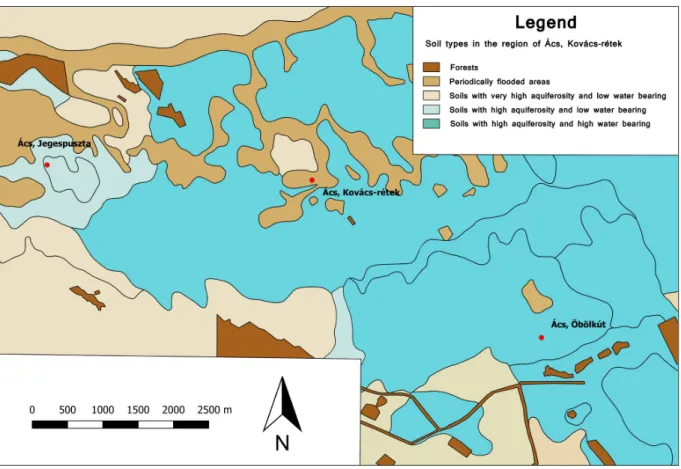
Given that the vicinity of Ács-Kovács-rétek is a mostly flat fluvial plain with very little variation in relief, the key part in its agricultural potential was soil quality and water availability. To analyze this in a local scale however, I needed relatively high resolution data, for which the obvious choice was the so-called DKTIR (Kreybig Digital Soil Information System)20developed by the Institute of Soil Sciences and Agricultural Chemistry of the Hungarian Academy of Sciences. This database contains a large variety of information about the soils of the region in question. However, for this research I only used the data on water balance, humus depth, and pH values. The data thus acquired shine an interesting light on the natural environment and agricultural potency in the region surrounding Ács-Kovács-rétek.
Surprisingly, the data shows that the site itself is located in a periodically flooded area, owing at least in part to a nearby stream. Evidence to this already came to light during the excavation:
some parts of the site could not be fully excavated due to the large amount of ground water. It is also possible that the large number of ditches found in the settlement can also be attributed to this factor, and thus served as a means of drainage. Even so, it is clearly evident that the immediate area of the village is not especially well-suited for agricultural use. Looking at the
19 See Orengo et al. 2010.
20 See Pásztor et al. 2010; 2012.
wider surroundings of Ács-Kovács-rétek, however, we can see that this kind of environment was not the most wide-spread in the area. While there are narrow, meandering areas that are at least periodically flooded, most of the soils in the area have high aquiferousity and good water-bearing ability, and mostly have a neutral or alkalescent pH value. These soils are generally well suited for agricultural use, and the large number of streams in the area (accompanied by a high level of ground water) would mean that water availability should not have been a problem. Therefore these attributes combined provide relatively good conditions for agriculture. However, there are some areas in the close vicinity of the site that stand out.
One of these is a 27 hectare region just 300 meters to the northwest of the settlement, which is situated on a very slight hilltop surrounded by periodically flooded areas. Its soils have very high aquiferousity and a neutral pH, and although their water-bearing ability is somewhat low, the average humus depth in this area is 10 cm deeper compared to the average of 50 cm measured in the general area. This (combined with the other attributes) means that the area is exceptionally well-suited for agriculture, which could potentially mean it had a priority in cultivation even in the Roman age, thus having influence over the land-choice of nearby inhabitants.
Fig. 2.Soil types in the region of Ács-Kovács-rétek.
If we summarize the above information we can see a clear trend developing in this site’s location. The village itself lay on land that was comparably ill-suited for agriculture, but rich in easily accessible water, which is very important for everyday life of a settlement. However, the immediate catchment of the village was rich in very potent soils in a radius close enough for economically feasible cultivation. This area (according to Vincent Gaffney and Zoran Stančič) has been determined as 5 km.21 These trends affirm the supposition that the choice of location
21 Gaffney – Stančič 1991, 36–37.
for the settlement of Ács-Kovács-rétek was a very calculated process, in which natural factors definitely played a role. The question is: can we deduce the same at the other sites in its vicinity, or is this an isolated phenomenon?
If we look at the site of Ács-Jegespuszta, a slightly different picture emerges. Although there are some temporarily flooded areas in its vicinity, the settlement itself is not located on one of them.
Instead, it is located on soils with high lime content, high aquaferousity and water-bearing ability, and a neutral to alkalescent pH, meaning relatively good soils. It cannot be said however, that the agricultural potential of this area was excellent: humus depth is only 20 cm, which is 30 cm shallower than the average in the region. Looking at the wider surroundings though, we can see several areas with good soil conditions all around the site, which were most probably prime candidates for agricultural cultivation.
In the case of Ács-Öbölkút the conditions are similar to Jegespuszta in many ways. According to the soil quality maps the site lies not on a temporarily flooded area, but on a region with lightly alkalescent pH, good aquaferousity and water-bearing ability. During the 2009 excavations at the site, however, researchers discovered remains of former watercourses. In addition to this, the average humus level was quite fluctuant, which together with the aforementioned riverbeds show that the area was very rich in water,22 and thereby convenient for a settlement.
Looking at the wider area around the settlement though, we can see some interesting trends. If we look at the whole catchment of the settlement, it has a much lower humus depth than the surroundings of the other sites, paired with fairly average soil attributes. This makes this area less potent for agricultural use than the catchment of the other sites studied here. However, a more detailed analysis of the catchment shows smaller pockets of slightly better soils that are mostly concentrated around the site of Ács-Öbölkút, which could have been a driving factor for settlement. Therefore even though the settlement is in one of the less potent areas in the wider region, it still holds one of the agriculturally better spots inside its wider area.
In conclusion we can see some interesting trends emerge in the locations of the settlements in the region surrounding Ács-Kovács-rétek. On the one hand we can see a preference for areas more suited for agricultural use: we can see this in any of the three sites available for study. In a more local context however, we can see that the settlements themselves are mostly not located on these potent soils, but some distance away from them, in agriculturally less favorable, yet water-rich areas. Although only one of the sites (Ács-Öbölkút) has a confirmed watercourse next to it,23the other two were located in a setting that had relatively high groundwater levels, where accessing water through wells was convenient enough to provide good conditions for the settlement.
This duality of influences strongly suggests that the settlements involved in this study were mostly agriculturally focused. This fact is further affirmed by the lack of evidence of industry at any of them. It also shows that their location was the result of a deliberate choice, and not just some coincidence. It has to be said though, that during this study I only looked at natural properties governing settlement choice. It is almost certain that social elements (administrative borders, military presence, etc.) and economic factors (roads) also had an effect
22 Fűköh 2011, 166.
23 In the case of Ács-Kovács-rétek a large ditch running across the village (Feature no. 11) has been excavated, but according to the stratigraphic context it was determined that it was not present in the active phase of the settlement, but dug later. Thus it was discarded as a water source for this analysis.
on settlement choice, but since data about these is scarce in this region I could not factor these into my analysis. It also has to be mentioned that although we only know three Roman age settlements in this area, this does not mean that there weren’t any more. Our knowledge on the topography of this region is still incomplete, and thus needs more research before we can be sure that the patterns we see in settlement location are genuine, and not just the result of us not knowing any of the sites that would not fit into them. It would also be advantageous to compare our findings with settlements from other parts of the province (or even the whole Empire), to see if the same conclusions apply there, or if the patterns we see here are influenced by some local phenomenon. Sadly, this is beyond the scope of my current research. Still, thanks to this look at the natural surroundings of Ács-Kovács-rétek we have a much clearer view of the environment it was situated in, and what could have motivated its former inhabitants to settle here. These findings also bring up new questions, however: did the natural environment have any visible effect on the inner structure of the village itself? If so, how did this manifest? For us to be able to examine this, we have to take a closer look at the site, and the features excavated in it.
2. The inner structure of the settlement at Ács-Kovács-rétek
2.1. GIS methods applied to the study of the settlement structure
During the excavations a total of 112 features dating to the Roman age were discovered at the site. These paint a picture of a settlement that is characteristic of the native population, lacking any stone buildings, consisting only of pit houses and wooden surface structures.
Beside the houses a large number of pits and trenches were discovered, encompassing the whole settlement area in a complicated system. In order to understand this system we have to analyze the direct and indirect connections between the features not only spatially, but in regards to the finds as well, thus creating a large web of data on the connections between many aspects of the features. By studying this data network it becomes possible to recreate the settlement’s structure layer by layer and document the changes within it. The complexity of such an analysis however requires an effectively structured GIS database that can incorporate both spatial and descriptive information together.
Creation of such a database was a key component of my study from the start. Doing so allowed me to store every bit of site information in one interconnected system, opening up a host of new options to analyze not only the descriptive or quantitative aspects of the features, but their spatial characteristics as well, both locally and (thanks to the projection system inherent in a GIS system) even regionally. Its structure also made it possible to compare these characteristics to those recorded at other sites by simplifying descriptive data conversion and enabling the information of different sites to be handled in the same framework on any necessary scale.
However, this need for connectivity brought with it a number of problems and solutions with it during both the planning and implementation phases. These problems are not unique to my system, but are general issues that have to always be kept in mind when building GIS systems with outside compatibility in mind, and therefore are worth expanding on in detail.
The first task of the development process was to convert the already existing data into formats suitable to the needs of a GIS system. Luckily, spatial information about the excavation was available in vector graphic format, although only as an AutoCAD DWG file. While this format is
very effective for vector drawings and representation, it lacks the ability to connect descriptive information to the graphical representation of the features. Also, DWG files only use a local coordinate system instead of a global projection system that is an essential component of a GIS database. These drawbacks of the file format meant that the data needed to be converted into a different format. After carefully weighing the options, it was decided that the ESRI SHAPE (.shp) format would be best suited for my research. Aside from fulfilling all the basic requirements for a GIS database it had a very important advantage over other formats (mainly MapInfo TAB): it is compatible with almost any available GIS software, including QGIS, which was used extensively during my research. The only downside of the format is that it can only utilize one kind of vector geometry (point, polyline of polygon) per database. This however could be circumvented by thematically distributing the different data types into several different databases. These can then be used in the same framework, thanks to their unified projection system, for which the EOV projection24was chosen, it being the most widespread system in Hungary. EOV is also meter-based, so the conversion from the DWG (which was drawn with the correct EOV coordinates in its local system) did not need any additional georeferencing.
The conversion from DWG to SHAPE resulted in several separate vector datasets containing polylines and points only, the latter being the geodesic reference points recorded during the excavation. The polylines depicted either the edges of features, or their interior details. As the database development progressed, the former (represented by closed polylines) were converted into polygons, each symbolizing one stratigraphic unit of the site, accompanied by one line in the attribute table of the database. In some cases more than one polygon makes up a stratigraphic unit (for example trenches excavated in several small segments). In these cases the polygons in question are grouped together, and are represented by one line in the attribute table. When one unit is inside another one (like in the case of postholes within buildings) the polygons representing them were placed atop one another. This presented some issues with drawing order (some features could not be selected on the map due to them being under larger objects), but these drawbacks were compensated by the relative ease of spatial measuring compared to the alternative (cutting holes into the polygons).
After the conversion and processing of the spatial information, the next step was the creation and formatting of the descriptive data that would be connected to the resulting polygons. This was a crucial element of the database development. In order to be able to analyze the data correctly I needed a structure that is clear-cut and searchable. Therefore I needed to separate the data into many small, concise categories that could be pliantly recombined, while also attempting to use quantified data in as many cases as possible. The end result was an extensive table of information that can essentially be divided into two main categories:
• Information related to the identification of the feature: this was based on the docu- mentation of the excavation, and contains data regarding the identification and general description of the features (ID numbers, feature type, etc.).
• Finds connected to the feature: the data in this group concerns the finds that have been found in the different stratigraphic units. Of the whole find spectrum, only the pottery and animal bone remains were used in the database, because other find types were too
24 EOV is short for „Egységes Országos Vetület”, EPSG: 23700.
few in number for an effective spatial analysis. Scattered coin finds have been put into a different database based on their recorded coordinates, each represented by a point.
The finds themselves have been structured as quantitative data: for every type of find a number of categories have been defined as columns of the attribute table, and the number of finds from the feature belonging to that category has been added to these as records.
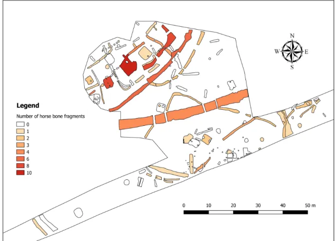
In the case of pottery the categories have been based on the categories defined in the separate, quantitative pottery database used for their sorting. In the case of the animal bones only the species they belonged to were used. This type of data handling made it possible to study the spatial distribution of features by the amount of finds of different types that have been found in them(Fig. 3).
Fig. 3.Example of the visualizations made possible by the GIS database.
The resulting database, due to its quantitative nature provided us with a very well searchable and filterable data structure. This meant that a number of analyses could be carried out to find trends in both the attribute data and the spatial information connected to it. And since the database utilizes projection systems, these trends can be compared to not only other sites, but to other types of spatial information as well (elevation models, soil maps, etc.), broadening the perspectives of site interpretation. With its help, it was much easier to discover and visualize the connection between features, and to paint as accurate a picture of the site in regards to its structure and its changes over time as possible.
2.2. Interpreting the features of Ács-Kovács-rétek
The 112 features dating to the Roman age that have been excavated at the site form a complex settlement structure that suggests that several rebuilding periods took place in the village. While features from other eras were also found at the site, these do not mix with the Roman settlement that spans most of the extent of the excavated area. Still, only parts of the whole settlement could be excavated, with an unknown amount of it remaining underground. While this fact hampers our ability to analyze the whole village together, even from this portion of it some relatively detailed conclusions can be drawn about the life and structure of the site in the Roman Age.
The site shows the picture of a typical rural settlement, mainly consisting of pit houses, interwoven by trenches and pits of various shapes and sizes, without any sign of stone buildings.
Settlements of similar character are known to have existed even before the Roman Age: a good example of this is the Iron Age site of Sajópetri.25 This sort of settlement then survived through the Roman occupation, mostly at the settlement sites of the native population, featuring pit houses dominantly even in the Late Roman Age. Trenches are also a dominant feature of these sites, creating a complex mesh around and between buildings, serving not only as boundaries, but as drainage ditches as well. A good example of such a complex is visible at the 2nd–3rd century phase of the indigenous settlement of Győr-Ménfőcsanak,26 the structure of which shows many similarities to the site of Ács-Kovács-rétek.
It is important to note, however, that even though the settlement structure demonstrated by Ács- Kovács-rétek is mostly characteristic of the native population, the use of pit houses themselves is not confined to indigenous settlements. Evidence, such as the settlements excavated at the site of Páty-Malomdűlő27and Budaörs-Kamaraerdő-dűlő28shows that they were in wide-spread use even in provincial, romanized settlements. It can also be seen at these sites that pit houses were used in every period of the settlement’s existence, many times next to and in correlation with stone buildings. Examination of the map of Budaörs-Kamaraerdő-dűlő also reveals quite extensive areas that only contain pit houses,29 even though the site itself was rich in stone buildings. Considering that in the case of Ács-Kovács-rétek only one part of the whole village was excavated, this means that we also cannot rule out the presence of masonry here entirely, even though so far no evidence has been found to support it.
The aforementioned evidence also suggests that even though the settlement itself was lacking any signs of urbanization, its inhabitants could have been romanized. This fact is also corrobo- rated by the artifacts found at the site. Among these a number of sherds belonging tomortaria have been identified, a type of vessel mostly attributed to provincial lifestyle.30 Similarly, the building style of the buildings also suggests a Romanized population: even though only pit houses were found, many of them containedtegulaeorimbricesin their filling, meaning that many of them could have had tiled roofs. This building custom is not typical of the indigenous people, and is mostly attributed to the Romans.
25 Szabó 2007, 201–227.
26 See Tankó – Egry 2009 27 Ottományi 2007, 140–205 28 Ottományi 2012, 103–104.
29 Ottományi 2012, 148–149.
30 Bónis 1991, 123.
Other than the roofing however, the pit houses themselves don’t give many clues about their occupants or function. Their structure mostly aligns with the standard forms that are present from the Late Iron Age through the Roman Age. The form of these buildings changes very little over time, although this variation makes it possible to typify them, most recently attempted by T. Budai Balogh.31 He bases his typology of these buildings on their size, and the number and arrangement of their posts, which could hint at the structure of their roofing. Altogether he defined three main building types, each having several subtypes. However, his analysis does not account for buildings that have an irregular shape. A number of such buildings have been found even at Ács-Kovács-rétek, and in other settlements too. They are very hard to reconstruct, since they don’t fit into any standard categories, and instead require each and every one to be reconstructed individually.32
Among those buildings that fit into regular categories the most frequent are the ones with oblong square shape, with two posts holding the roof, each near the middle of the shorter side inside the pit. This type can be observed frequently not only in Celtic settlements like Sajópetri-Hosszú-dűlő,33but also in provincial villages, even in the Late Roman Age.34 Variants of this type also include houses with the same shape, but with a different number of posts. In some cases, identification of these posts (and thus the reconstruction of the roofing) is quite problematic, as they can lay outside the pit, where their exact connection with the building can be questionable.35 Sometimes their remains are hard to identify even inside the buildings:
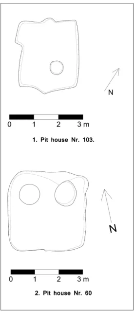
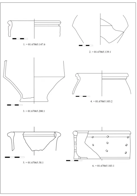
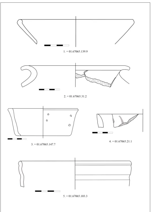
such is the case of Feature No. 103 in Ács-Kovács-rétek, where the only sign of roof-bearing posts were two small nooks in the shorter wall of the pit(Fig. 4.1).
Similarly to other villages, the largest number of houses in Ács-Kovács-rétek also belonged to Budai Balogh’s Typ II.C. A total of five such buildings were discovered: features No. 53, 70, 88, 95 and the aforementioned No. 103. Their size varies between 6.7–17 m2, while their shape is mostly rectangular, with a certain degree of irregularity and roundedness at the corners evident in all of them. All but two of them had only two posts holding the roof up: in the case of No. 88 and 95 however, several other posts were discovered by the longer side of the house.
Furthermore, house No. 88 had a large rectangular-shaped extension at its northwestern edge.
Though stratigraphic evidence suggests that it was coexistent with the building, no postholes were to be found in this extension, thus it is uncertain if it had any roof over it, or even its function or connection to the house itself. A similar problem exists in the case of house No.
83: here a small shoulder could be found in the side of the pit, likewise without any postholes, or any evidence to point out its exact function within the building. Questions such as these however show just how problematic the interpretation of pit houses can be.
Aside from these houses a further three more have been excavated where although evidence of posts have been found, the shape of the pit and the arrangement of the posts are different from the aforementioned type. The best example among these is feature No. 98: this partially excavated, rectangular-shaped building had postholes at the mid-point of all three of its known
31 Budai 2009, 86–100.
32 Tímár 2009, 100.
33 Szabó 2007, Fig. 20.
34 Budai 2009, Typ II.C, 91–93.
35 Budai 2009, 86.
sides. Sadly the fourth side of the building lay beyond the boundaries of the excavation, thus we have no information about a fourth posthole that may or may not have existed there. It is also worth mentioning, that evidence of a fireplace has been found in the northwest corner of this house, which although in regional context is not particularly unique,36in the case of Ács-Kovács-rétek this is the only house where such a feature has been found.
Fig. 4.Pit houses from the site of Ács-Kovács-rétek. No. 103 (1) has two probable postholes represented by nooks in the pit wall, while No. 60 (2.) has no observable postholes.
As we can see even though evidence to the posts holding the roof has been found in many of the houses, their interpretation and reconstruction is still questionable. Even more problematic are the houses where no such features have been found and only the pit itself remained. In the case of Ács-Kovács-rétek a total of three buildings belong to this category: features No. 60(Fig. 4.2), 83 and 93. Reconstruction of the structure of these houses is still very problematic, even though a number of them have been found at provincial settlements like Budaörs-Kamaraerdő-dűlő37
36 Budai 2009, 97.
37 Ottományi 2012, Fig. 89, B1.
or Ménfőcsanak.38 In both of these cases a structural wall has been theorized as to be holding the roof without the help of posts, although the exact reconstruction of such a structure is still questionable. A similar reconstruction has been hypothesized for a house in Sajópetri-Hosszú- dűlő, the structural wall being a wattle-and-daub construction supported by small posts.39 This is unlikely to have existed in Ács-Kovács-rétek though, since the posts would have needed at least some smaller postholes, none of which have been found here. It is possible, however, that their remains were simply too shallow to be recoverable, and thus were missed during the excavation. It is also possible that the structural wall consisted of logs or bricks, as hinted at by ethnographic analogies.40 These kind of walls would need no postholes or foundation to be built, although the use of bricks as building material can probably be precluded as no evidence of bricks (apart fromtegulae) have been found at the site. The use of logs as building materials also have no evidence currently to support it. The interpretation and reconstruction of pit houses without postholes therefore still remains questionable.
Another very important, but still very problematic question pertaining to pit houses is their function. As their standardized structure suggests, their forming is mostly functional. No attributes are presently known that would differentiate a building used for industry from one used for living41 aside from some specific finds, of which not much has been found in Ács-Kovács-rétek. The only notable example comes from house No. 93 in the shape of a spindle-whirl, hinting at a possible industrial use for the building. It is worth noting however, that several functions could have overlapped, one house being used for both living and industry.
Therefore even if some evidence of industrial use comes to light from a certain building, some degree of a living function cannot be ruled out, orvice versa.
As we can see from the aforementioned sections, many questions still remain about the houses excavated at Ács-Kovács-rétek. Despite this, there are certain trends that do tell us something about the settlement and its inhabitants. Even though there is a certain degree of variance in the structure of the excavated houses, all of them belong to the same category, predominantly attributed to the indigenous Celtic population. There is no sign at all of pit houses with large number of posts along their longer sides, a building type mainly linked to barbarian immigrants of the Late Roman Age by T. Budai Balogh.42 This hints at a population mainly consisting of Romanized local elements.
In light of this however, it is interesting to note that surface buildings supported by posts are also missing at the site, even though they are quite common in provincial settlements dating from the 2nd century AD onwards.43 Though postholes arranged in a line have come to light both in the northern (Feature No. 92) and southwestern (Feature No. 19) part of the site, these cannot be reconstructed exactly as buildings, since in both cases only one line of postholes have been found. It has to be noted however, that Feature No. 92, a linear structure consisting of seven postholes, runs almost parallel to the boundary of the excavation, therefore it is possible
38 Tankó – Egry 2009, Fig. 7.
39 Szabó 2007, Fig. 7.
40 Tímár 2009, 95.
41 Budai 2009, 77–81.
42 Budai 2009, 101, Typ II.F.
43 Budai 2009, 82. For examples of other such buildings see Gabler – Ottományi 1990.
that other parts of the structure (that could possibly identify it as a surface building) could still be underground. Until further study however, this possibility cannot be verified. The same is the case with Feature No. 19.
Another interesting feature is a large cluster of postholes (18 in total) scattered around the southern part of the site.44Their presence suggests some sort of surface structure. Their scattered location however does not allow any conclusions to be drawn as to what this structure might have been, or even if they belonged to only one structure. Together with all other buildings (both pit houses and surface structures) they still remain questionable, and in need of further study.
Aside from buildings, a variety of other features have also been found at the site, of which 37 are pits of various shapes and sizes. Their most likely uses have been for storage or garbage disposal, although it is impossible to pinpoint any of them to only one of these uses. They mostly contained only a very small amount of finds (both in respect to pottery and animal bones), with the one exception being Feature No. 40. While the average number of pottery sherds found in pits throughout the site was only 4.19 with animal bones at 2.63, pit No. 40 contained a total of 93 sherds and 34 animal bones. This makes it highly likely that this particular pit can be identified as a garbage pit. Such identification is not possible at any of the other pits.
Compared to the number of pits, fireplaces were even less plentiful: only two features could be identified as such. One of them was Feature No. 79, located in the northwestern corner of house No. 98, the only such feature at the site that is connected to a building. The only other known fireplace is feature No. 35, an open fireplace. Not much else is known about this feature, since its condition made any kind of reconstruction impossible.
By far the most numerous of features were the trenches encompassing the whole site. Every one of these had a U-shaped cross-section, and although their walls were mostly steep, not one of them had an even V-shape. They probably had dual uses, with water drainage and border-marking both being likely and very hard to get apart. In many cases the bearing of a trench could indicate a border function. A good example of this is trench No. 59, which starts out running in a southeastern direction, with a perpendicular change roughly in the middle, thus encompassing an area that contains (amongst others) several buildings, the orientation of which match almost perfectly with the trench. This, similarly to trench No. 108 and 112 makes it very likely that at least part of its function was to delineate the border of a household, or some other spatial structure. Identification of such spatial features in the settlement is very important, especially since no clear roadways have been found that could indicate the interior organization of the village. The complex stratigraphic nature of the trenches in Ács-Kovács-rétek however makes identification of any household units very problematic, and thus only a partial picture can be drawn of it in this regard as of yet.
Even more problematic is the identification of a water drainage function for the trenches. A possible indicator of such could possibly be the gradient and direction of their declination.
After careful analysis of this data (in comparison with a surface model built from geodetic points of the excavation) however, no clear structure could be observed. There were some features that had a consistent direction of declination throughout their length, but in most cases
44 Some of them belong to Feature No. 85, some do not have a Feature ID number.
this coincided with the natural declination of the surface relief. No trench that had a different direction of declination than the surface relief (which would be a sure sign of deliberate drainage planning) has been found. Also, no uniformity in declination directions among trenches could be detected anywhere in the site, therefore even if the trenches had a drainage purpose, they did not drain the water to one certain area. This however does not mean that the trenches did not serve water drainage purposes to at least some degree, especially since the site was located in a periodically flooded area. It is very likely instead, that these trenches had dual purposes, which cannot be exactly separated from each other.
As it can be seen from the aforementioned section, many questions still remain about the features excavated in Ács-Kovács-rétek both individually, and as an interconnected structure that built up the settlement together. Their frequent overlaps make it hard to recognize any complete structure for the settlement, but also prove that the village had undergone changes at least once in its lifetime. Therefore it is essential for the reconstruction of the settlement to separate these periods from each other. This however is not possible by looking at the features alone: as the above shows their structure is too general for that. The only way to do so is to analyze the artifacts that have been found in them that can tell us more about not only the chronology of the site, but the inhabitants as well.
3. Analysis of the find material of Ács-Kovács-rétek
A total of 1002 artefacts have been unearthed during the excavations of Ács-Kovács-rétek, their nature very diverse: aside from the most numerous pottery sherds and animal bone fragments, a number of glass, metal and bone items have come to light. These items tell a lot about the everyday lives of the inhabitants, as well as helping us determine the timeframe in which the settlement was occupied, and the changes that occurred during this time.
3.1. Pottery
By far the largest in number from the artefacts are pottery fragments: a total of 857 pieces belong to this group. They came to light scattered all across the settlement, meaning their careful analysis both in respect to the finds themselves and their spatial situation was paramount to understanding the nature and temporal breakdown of the settlement.
One of the biggest problems that arose during the analysis was the fragmented nature of this find group. Most of the pieces that came to light were only small fragments of vessels.
Furthermore, most of these pieces contained only the body of the vessel (a total of 470 pieces, 54.8% of the whole pottery spectrum), which tell us only a limited amount of information about the whole shape of the vessel. Meanwhile, vessel rims account for only 21.8% (187 pieces), and bases for 20.3% (174 pieces) of the total assemblage. Due to these percentages, only a handful of vessels (133 pieces, 15.5% of the whole collection) could be adequately classified according to their shape, while the rest could only be partially identified.
The aforementioned problems made it very important to analyze the available assemblage not only in a qualitative way, but from as many aspects as possible in order to maximize the information gained from them. To be able to achieve this, I needed a sorting system that helps to capture as much quantitative data as possible, and enables the creation of a well-structured
database. The best solution for this was the adaptation of the sorting system employed during the analysis of both the excavation of Mount Beuvray,45and the previously mentioned Sajópetri- Hosszú-dűlő.46The basis of this method is that every aspect of every sherd is classified according to a predefined set of classes that cover every aspect of their physical and descriptive character.
Every class has a codename, and thus in the end every single sherd can be characterized with a simple, easy-to-decrypt code sequence, every code segment describing different aspects of their character. This data can then be handled easily in a tabular format, one that then can be well filtered and easy to search. Also, by reconfiguring this tabular data it is relatively easy to gain detailed quantitative data about different aspects of the site’s find material.
For the sake of this sorting system, the pottery assemblage of Ács-Kovács-rétek has been sorted into six main categories:
1. quality (by the crudeness of tempering materiel) 2. color of the vessel’s fabric
3. production method (wheeled, hand-made, etc.) 4. vessel type (pot, dish, etc.)
5. sherd type (body, lip, etc.) 6. decoration type
To make searching in the database easier, decoration modes have been divided into two subcategories:
• applied decoration: every type of decoration that involves the application of any material (paint, etc.) to the surface of the vessel
• incised decoration: every type of decoration not involving the application of any material on the surface of the vessel, instead involving the modification of the raw surface At the end of the sorting process, the above mentioned method resulted in a well-structured tabular database that was easy to filter and quantify. This made it possible not only to analyze trends and correlations within the pottery assemblage statistically, but the well-structured dataset was also applicable to GIS databases, enabling the observation of spatial correlations within the find material as well.
3.1.1. Conclusions about the pottery assemblage as a whole
The structured database allows us to analyze not only individual vessels, but the composition of whole subgroups, or even the whole pottery assemblage of Ács-Kovács-rétek as well. By studying this data, certain trends become visible that tell us a lot about the inhabitants of the settlement.
One of these trends is the large percentage of coarse wares in the assemblage: 712 sherds (83% of the whole material) belonged to this relatively poor quality category. The question
45 Szabó 2007, 229–234.
46 See Szabó – Tankó 2007.
is: does this mean that the inhabitants of the village were relatively poor compared to other settlements, or does this percentage fit into larger regional trends? To answer this, we need to compare our data to other similar sites in Pannonia. However, since most publications do not contain such exact numbers, the number of sites I could compare to was relatively small. In respect to civilian sites, it was limited to Tokod-Erzsébet-akna,47Budaörs-Kamaraerdő-dűlő,48 Szakály-Rétiföldek,49and the road station of Fertőrákos-Golgota.50
Given however, that some of the artefacts, and the proximity of the Danube suggests at least some degree of connection to the military at Ács-Kovács-rétek, it was deemed necessary to not only analyze other civilian settlements, but assemblages with military connections as well. Therefore the military camps of Ács-Vaspuszta,51 the military town of Carnuntum,52 and the pottery workshop next to the watchtower of Leányfalu53 were also included in the study, lending a much broader spectrum of data.
These analyses yielded some interesting results, especially when we look at military-related sites. The percentage of coarse wares observed at Leányfalu was much lower than those at our site, with only roughly half of the total pottery assemblage.54 Similar ratios could be seen at Ács-Vaspuszta as well: here, out of the 572 sherds of published Late Roman pottery, only 295 pieces (51.6%) were classified as coarse wares.55 These, however are all sites that are closely related to the military, therefore the evident difference in pottery quality from Ács-Kovács-rétek brings up a very important question: is this difference only an evidence of the relative poverty of Ács-Kovács-rétek, or is this a common difference between military- and civilian settlements?
The answer to these questions lies within the analysis of other civilian settlements in Pannonia.
The results of these analyses draw a starkly different picture. In the case of Tokod-Erzsébet- akna, coarse wares took up 92.87% of the total pottery assemblage.56 Similar numbers can be observed at the Late Roman period of Szakály-Rétiföldek as well.57 Furthermore, looking at other settlements proves that these trends are by far not confined to Eastern Pannonia: while in Carnuntum the percentage of imported wares in the pottery assemblage was 21.13%,58such vessels in Fertőrákos-Golgota only took up 4.4%.59 Of course the latter number be directly converted into ratios of coarse wares (since there are a number of locally made types of fine wares), the trend is very similar, the number of high-quality vessels being considerably lower in rural settlements than in settlements with military ties closer to the Danube.
These trends, while statistically in need of further refinement and more data, still show that there is at least some degree of connection between the wealth and the profile of Late Roman
47 See Mócsy 1981.
48 See Ottományi 2012.
49 See Gabler – Ottományi 1990.
50 See Gabler 1973.
51 See Gabler 1989.
52 See Grünewald 1979; 1986; Gassner 1990.
53 See Ottományi 1991.
54 Ottományi 1991, 7.
55 Gabler 1989, 577.
56 Mócsi 1981, 84.
57 Gabler – Ottományi 1990, 174.
58 Gabler 1996, 160.
59 Gabler 1973, 168.
settlements, with military-based populations generally using more high-quality pottery than populations of civilian nature. It is likely however, that these trends cannot be explained by the different social and monetary stance of these populations alone. A very important factor that also has to be considered is the effect of the Danube, one of the most important trade routes between Pannonia and the rest of the Empire, and thus the most important source of imported wares in the province.60 Influence of such a trade route could explain the spatial difference between the composition of assemblages from different settlements, but with the military focus being on the Danube as well, it is hard to distinguish their influence from the effects of the Danube. For starker conclusions to be possible, some further, more detailed research is still required.
Even though the aforementioned questions regarding the influence of certain factors in the artefact assemblage of settlements remain, the analyses still help us to draw some conclusions about Ács-Kovács-rétek. While it is located clearly in the hinterlands of theRipa Pannonica, the ratios of the artefacts found at the site point towards more of a civilian population, resembling the characteristics mainly attributed to settlements further away from the border, with only a relatively smaller number of fine wares observable, and almost no imported wares at all (except for a few sherds of Samian Wares). Still, even though they only take up a small percentage of the pottery material, this subgroup contains a relatively large variety of vessel types, showing that the settlement’s inhabitants had more than a few connections to the provincial economy.
In order to understand the extent and characteristics of such a network, however, we need to look at each of the different vessel types found at the site. Such an analysis could not only show how wide the ties of the settlement are, but could also provide a large amount of information about its inhabitants, and the timeframe in which they occupied this area.
3.1.2. Analysis of the fine wares found at Ács-Kovács-rétek 3.1.2.1. Imitations of Pompeian Red Wares
During the excavations of Ács-Kovács-rétek a very small amount of sherds (three in total, 0.35%
of all pottery and 2.07% of the fine wares) have been found that can be identified as imitations of Pompeian Red Wares. It is probable that these sherds belonged to only two different vessels, which were found in pit No. 40 in the southwestern part of the site.
Both of these vessels belong to one well-defined type of pottery, found at a number of different sites in Pannonia. Generally, these wares are all identified as bowls with a yellow fabric, and a strong, shiny red slip applied to the interior surface only. Their origin can be traced back to Italia,61from where they were exported to other parts of the Empire in large quantities. While their production in Italia is likely to have ceased around the end of the 1st century AD,62 their local production might have continued even until the 3rd or 4th century AD,63 including some workshops in Pannonia. It is very likely that the sherds found at Ács-Kovács-rétek belong to these locally made types as well, although their exact place of origin is still unclear, since the making of such vessels was very generalized throughout the Empire, showing little to no
60 Gabler 1996, 161.
61 Schoppa 1961, 58.
62 Gabler 1989, 476.
63 Gabler 1977, 163.
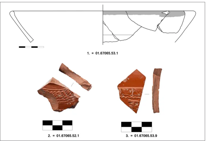
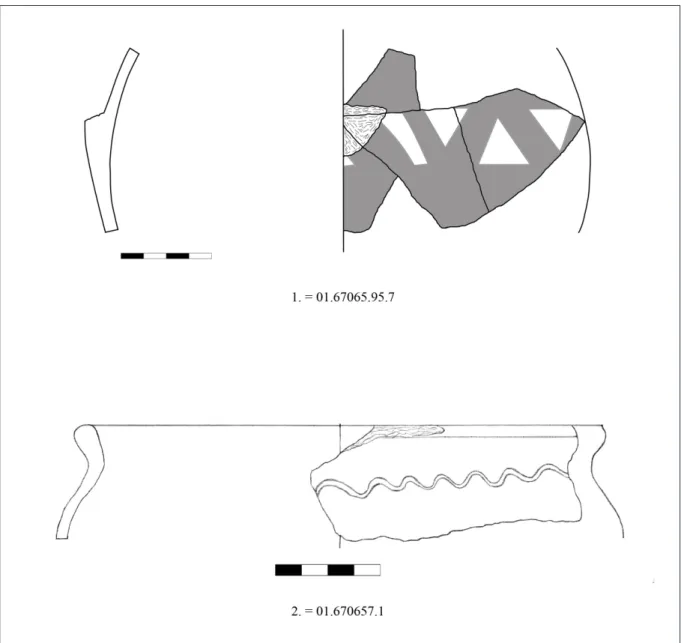
variety.64 Through the analysis of the composition of the interior slip,65 however, it can be confirmed that production of such vessels did take place in Pannonia, a fact already theorized66 earlier based on the finds at several pannonian sites. According to these finds, sherds of this type were most prominent in Pannonia in the 2nd century AD, although their production in several places (such as Brigetio67) could have lasted until the end of the 3rd century AD.68 The characteristics of the Pompeian Red Ware imitations found in Ács-Kovács-rétek conform to those found in many other places around Pannonia. Their fabric is of good quality, and yellow of color. Their rims are straight, or slightly inverted. The red slip completely covers the interior, while the exterior remains bare, except for a small portion of it just below the rim of the vessel.
In one case a small, horizontally incised line is added at the edge of the painted area on the exterior(Fig. 5.1), while the interior has no decoration except for the slip. Their analogues have been found both in Brigetio69 and Ács-Vaspuszta.70 This implies the possibility that they were made in a local workshop, possibly in Brigetio, although without further evidence this designation still remains questionable.
All of the sherds belonging to this type have been found in one pit in the southwestern part of the site, relatively far from the settlement’s core. Their exact dating is questionable at this time, although stratigraphic evidence suggests that they were buried no earlier than the Severan period, making these some of the earliest finds of the site. The fact that they exist here shows that the settlement’s population was Romanized to some degree even in its earlier stages.
3.1.2.2. Terra Sigillata
Similarly to the Pompeian Red Wares,terra sigillataecame to light in very small numbers at the site: only three sherds were found, all of them relatively small in size and in bad condition.71 Also similarly to the Pompeian Red Wares, all of them came from the same area in the southwestern part of the site. Both their small size and their worn-out quality make their exact identification difficult, and indicate that they were used for a relatively long time before being buried, making their exact dating problematic.
The oldest of the sherds originates from La Graufesenque, and was probably made at the end of the 1st or the beginning of the 2nd century AD(Fig 5.2). Its exact vessel type is unidentifiable due to its size. Though its exterior contains some decorations in the form of two horizontal lines with floral ornamentation in between, the prevalence of this decoration type on vessels from this workshop prohibits the identification of the vessel even through possible analogues.72 The second identifiable sherd found at the site is considerably younger, fitting better into the probable timeframe of the settlement. It originates from a workshop in Schwabmünchen, and was probably made in the Severan period, belonging possibly to a Drag. 37 type bowl(Fig. 5.3).
64 Peacock 1977, 176.
65 Gunneweg et al. 2004, 33.
66 Gabler 1977, 163.
67 Gabler 1989, 476.
68 Pásztókay-Szeőke 2001, 15, note 46.
69 Fényes 19998, 45–46.
70 Gabler 1989, 476.
71 The identification of the Samian Ware sherds was carried out by Dénes Gabler, for which I’m very grateful.
72 Mees 1995, Taf. 43.1.
Its decoration contains an ovolo motif, with an unidentified figure in a relief-field underneath, separated from the ovolo by a zigzag line. Its analogues have been found at a number of places, including Brigetio,73 where a similar sherd (decorated by the figure of a boar) has been found, similarly originating from the same workshop.
Aside from the aforementionedterra sigillatapieces, only one other has been found at the site.
However, its bad condition and lack of decoration prevented any kind of identification. This worn-out condition exemplifies the problematic nature of these vessels, although it also shows that the vessels in question were used for a long time, making it probable that even the oldest of them was only buried somewhere around the Severan period, a fact corroborated by other finds from the same features as well. Still, the presence of Samian wares further underlines the probable Romanized nature of the settlement’s inhabitants74even in the early stages of its habitation.
Fig. 5.Pompeian Red Ware Imitation (1) and Samian wares (2–3) from Ács-Kovács-rétek.
3.1.2.3. Vessels with color coated horizontal bands from Brigetio
Although more numerous than the previous types, vessels from Brigetio with color coated horizontal bands were still only found in a small quantity, with only 5 sherds known from the site. All of them came from a single feature, ditch No. 47, but due to their fragmented condition it is impossible to tell how many vessels they belonged to originally. Their matt-red coated decoration however, helps to characterize them as vessels belonging to a specific type that is very characteristic, but not unique to this area.
73 Gabler 1985, Abb. 1.1.
74 For more information on Samian wares, see Gabler 2006.
This matt-red coating, mostly found on the top third of the vessel (with other parts of the vessel left bare), and often complemented by “dotting-wheel” or incised linear decoration, is very characteristic of this vessel type.75 The fabric of the vessel is always of high quality and has a yellow color. Origins of such vessels can be traced back to Celtic pottery.76 After the Roman conquest of Pannonia, their use has spread throughout the province, with workshops known in Poetovio,77Aquincum78and in the vicinity of Lake Fertő79from as early as the 1st–2nd century AD. It is probable that the making of such vessels spread from these workshops to Brigetio,80 where in the 3rd century their production became the most prominent in the province.81 The most typical vessel forms belonging to this type are handle-less jugs with outcurving rims, horizontal-rimmed pots, round-bodied vessels, wide-rimmed jugs with one handle.82 In some cases even round-bodied jugs with three handles83have been found to belong to this type. Most of them are thought to have been made in military workshops,84 with production traceable through the entirety of the 3rd century.85 A sharp decline in the number of finds, however suggests that their production is likely to have stopped around the end of the century.
According to this information it is very likely that the vessels of this type found at Ács-Kovács- rétek can be dated to a period between the end of the 2nd and the end of the 3rd centuries AD.
Due to their fragmentation, however, their exact analogues, or even the form of the vessels they belonged to cannot be identified. Their presence, however tells us that the settlement was definitely active during the 3rd century AD, and had at least some degree of economic connections within the region, possibly with the town of Brigetio, where such vessels were made in abundance.
3.1.2.4 Pannonian grey slip ware (Pannonische Glanztonware)
Among the fine wares found in Ács-Kovács-rétek, Pannonian grey slip wares represent the largest group: a total of 31 sherds belong to this category, which accounts for 24.8% of the fine ware assemblage. The type itself is generally characterized by a light grey colored fabric of very good quality, with a shiny, grey colored slip covering both the exterior and the interior of the vessel.
The majority of identifiable sherds found at the site belong to dishes, with one exception being a pouring vessel with steep walls. In most cases the pieces did not contain any decoration beside the slip. The stamped decoration so often attributed to this type of pottery is also nowhere to be found here. This makes their exact identification and the finding of analogues very hard, since most typologies and publications about these vessels concentrate on the stamped decoration
75 Bónis 1970, 71.
76 Póczy 1958, 64; Bónis 1969, 167.
77 Bónis 1970, 80.
78 Póczy 1956, 94.
79 Gabler 1973, 158.
80 See Bónis 1975.
81 Bónis 1970, 78.
82 Bónis 1970, 74–75.
83 Póczy 1958, 66.
84 Bónis 1970, 82.
85 Gabler 1973, 158; Gabler 1996, 153.