PALAEOKARST
STUDIES IN HUNGARY László Korpás
Cover sheet:
Early marine caymanite in the cavity of the Late Eocene Szépvölgy Limestone, Mátyáshegy, Buda Hills
PALAEOKARST
STUDIES IN HUNGARY L ászló k o r pá s
BUDAPEST, 1998
Vol. 195 of the Occasional Papers of the
Geological Institute of Hungary
© Copyright Geological Institute of Hungary, 1998 All rights reserved!
Revision by
László Jakucs Dr. Sc. (Hungary) László Kordos Dr. Sc. (Hungary) Dr. Arthur Satterley (United Kingdom)
Linguistic revision by Dr. Arthur Satterley
Technical edition by Dezső Simonyi
DTP Ildikó Tiefenbacher
Published by the Geological Institute of Hungary H—1143 Budapest, Stefánia str. 14., Hungary
Responsible editor Károly Brezsnyánszky
director
ISBN 963 671 1917
Sponsored by
MOL
HUNGARIAN OIL and GAS Company
Litograph
Contents
INTRODUCTION... 7
/. PALAEOKARST SYSTEMS AND GEOLOGICAL MODELS...8
1.1. Introduction... # 1.2. What we know about the palaeokarst to d a y...8
1.3. Geological models o f palaeokarsts ...16
1.4. Conclusions... 19
1.5. Exploration strategies and methods o f study ...20
2. WORLDWIDE EX A M P LE S...22
2.1. B aham as...22
Geological setting ...22
Palaeokarst interpretation...22
2.2. Gulf o f Mexico (West Florida, Campeche Bank — M exico)...22
Geological setting ...22
Palaeokarst interpretation...24
2.3. C u b a...24
Regional geology and evolution...24
Pan de Guajaibon, West Cuba ...25
Punta Maisi-Punta Caleta, East C u b a...29
2.4. England...29
Geological setting ...29
Palaeokarst interpretation... .... 30
2.5. Spain...30
2.5.1. Catalan Range ...30
Geological setting ...30
Palaeokarst interpretation...30
2.5.2. Mediterranean coast, Cap Salou ...30
Geological setting ...30
Palaeokarst interpretation...31
2.5.3. Mediterranean coast, Cap Blanc ...32
Geological setting ...32
Palaeokarst interpretation...32
2.6. Greece... 32
2.6.1. Peninsula Peloponnessos, K o rfo s...32
3. PALAEOKARST AND CARBONATE PLATFORMS ...34
3.1. Fundamentals ...34
3.2. The m o d e l...34
3.3. Conclusions...35
4. PALAEOKARST SYSTEMS IN HUNGARY...36
4.1. O verview... 36
4.2. Selected genetic case studies ...37
4.2.1. Szabadbattyán (Kőszár-hegy)...38
Geological setting ...38
Palaeokarst features and interpretation...38
4.2.2. Orfű (Sárkány-kút) ...59
4.2.3. Balaton Highland (Litér, Hajmáskér) ...39
Geological setting ...39
Megyehegy D o lo m ite...39
Berekhegy L im esto ne...44
Palaeokarst interpretation... .. > ...44
Geological evolution...47
Palaeokarst evolution...49
4.2.4. Vác (Naszály H ill)... 50
Geological setting ...50
Depositional system ...50
Palaeokarst p h a ses... 50
Palaeokarst evolution...57
4.2.5. Pisznice cave ...57
4.2.6. Csővár (quarry and Várhegy c a v e )..... .58
Geological setting ... 58
Palaeokarst features and interpretation...58
Palaeokarst evolution...60
4.2.7. Buda Hills (Rózsadomb) ...62
Geological setting ...53
Triass i c...53
Mátyáshegy Formation (platform margin member)...63
Mátyáshegy Formation (intraplatform basin member) ...63
Maindolomite ...65
Cretaceous ...66
Bauxite, red c l a y...66
Eocene ...68
Basal conglomerate and breccia...69
Szépvölgy Limestone . ... 69
Palaeokarst o f the Szépvölgy Limestone ...69
Eocene-Oligocene ...8!
Buda M a rl...81
Palaeokarst o f the Buda M a rl...83
O ligocene...83
Tard Clay ... 83
Kis cell C lay...84
Q uaternary...84
History o f evolution ...84
Palaeokarst evolution...92
4.2.8. Buda Hills (Páty) ...95
Geological setting ...95
Palaeokarst features and interpretation...95
4.2.9. Buda Hills (Várhegy)...96
Geological setting and stratigraphy...96
Palaeokarst fe a tu r e s... 99
Model o f karst evo lu tio n... 100
4.2.10. Bükk Mountains...100
Lillafüred...100
Miskolc-Tapolca...100
Felsőtárkány ... 101
5. THE 3D MODEL OF THE COMPOSITE KARST SYSTEM, BUDA HILLS . .102 5.1. Aims and methodology . ' . ... 102
5.2. The 3D model and its im portance...103
6. THE PALAEOKARST POTENTIAL OF HUNGARY .../O7 ACKNOWLEDGEMENTS ...114
REFERENCES...115
PHOTOS ...127
APPENDIX...139
Introduction
One o f t o d a y ' s largest provocation for society is its supply o f healthy potable w a ter. Just this phrase itself, used frequently in
politics, reflects very well the day by day and more and more lim
ited provision o f this primordial human right. It seems to be catisal, that the possession o f potable water has become one o f
the strategic tasks in many places o f the world. Potable water supply is nowadays in the focus o f many national and interna
tional conflicts and it could become even more so in the future.
Hungary, because o f its geological setting and favourable geo
graphic and climatic conditions is in possession o f the largest sub
surface water resources in the region. The natural equilibrium o f these resources with quality o f potable water, has gradually broken
up because o f the effects o f exaggerated exploitation and industri
al pollution.
There fore the welfare o f future generations requires us to stop this process, already irreversible in human life-scale in order to satisfy the need for drinking water.
The surface and subsurface palaeokarst systems in Hungary
represent a resource great value for the population. They give about 10% o f the subsurface, partly thermal water resources, approximately 30% o f the petroleum reserves, all o f the bauxite,
limestone and dolomite resources and a significant part o f man
ganese ores.
The caves have extraordinary value in themselves, with their minerals, fossils and living flora and fauna. The surface occur
rences o f these palaeokarst systems have a specific role in the fo r
mation o f the landscape and in the evolution o f the biosphere. They are o f increasing importance for human ecology.
Consequently the palaeokarst systems have huge natural poten
tial. Exploitation o f any elements this potential should be real
ized exclusively on the account o f the other ones and could result in the break up o f its equilibrium. This process deterioration
was generated by the effects o f mining activity, o f industrialization and urbanization some ten years ago, which resulted in the accel
eration of a considerable drop o f the karst water table, influenced by climatic changes too, and resulted in increasing, sometimes
critical pollution o f the palaeokarst systems. Among the elements o f the systems the environmental factors, the quantity, quality and
the state o f the karst waters have become decisive. Therefore the aim o f the present study is to contribute to the protection and to the
rehabilitation o f the palaeokarst aquifer systems.
1.
Palaeokarst systems and geological models
Introduction
The investigation of palaeokarsts has become an outstanding area of research in the past 20 years as proved by the wide range and of the related natural and mineral resources potential (oil, bauxite, Pb-Zn ores, uranium ores, manganese ores, phos
phates, nitrates, groundwater and thermal water, Table 1). The timeliness and signifi
cance of palaeokarst studies is enhanced by the fact that 35% of oil, 15% of bauxite, 10% of Pb-Zn and 10% of water reserves of the world are located in palaeokarst areas.
Since a considerable part of mineral resources (such as the bauxites, most karst and thermal waters in Hungary and some oil fields in SW Transdanubia, in the south
ern part of the Great Hungarian Plain}'are connected with palaeokarst, in 1989 the Geological Institute of Hungary began a systematic study of the palaeokarst systems in Hungary.
The research aims to clarify the following points:
— time and environmental conditions necessary for the formation of palaeokarst,
— the criteria for recognition of palaeokarst,
— the role of palaeokarst in carbonate diagenesis,
— the role and significance of palaeokarst horizons in local and regional strati
graphic correlation as well as in geodynamic reconstruction,
— genetic-paragenetic relations between palaeokarsts and related natural potential,
— 3D models of palaeokarst systems.
The solution to the above mentioned problems is expected to provide an up-to- date explanation of the genesis of palaeokarst on the one hand and the conceptual renewal of the research and exploration strategies of the natural potential related to palaeokarst on the other.
1.2. What we know about the palaeokarst today
Before discussing our present knowledge of palaeokarst it is desirable to define the notion itself. This is necessary because all kinds of palaeokarsts can be classified as
“karst”, while the palaeokarstic origin of some of them, especially those at the sur
face, can be verified only with great difficulties or in no way at all. This also means that our research is limited to palaeokarst sensu stricto.
Defining palaeokarsts we used the definition of WRIGHT (1982), ESTEBAN and KLAPPA (1983), CHOQUETTE and JAMES (1988), BOSÁK et al. (1988) accord
ing to which palaeokarst was formed over geological time. The statement is evident in the case of karsts filled with younger sediments (covered karst), whereas with uncovered, relict or exhumed karsts it can be applied only occasionally. From among the general (morphological, hydrodynamic, hydrochemical, biochemical, lithologic, climatic and tectonic) conditions of palaeokarstification also specified by the above authors we could emphasize the statement by ESTEBAN and KLAPPA (1983) who point to proper “diagenetic facies” as a distinct marker.
Further on we deal with the particulars of the environment in a wider sense (facies, morphology, infillings, syn- and diagenesis).
8
1.1.
Table 1 Examples of some raw material occurrences related to palaeokarst
Raw material type
Palaeokarstic reservoir formation Occurrences
Name Lithology Age Cover Place References
Petroleum San Andres D olom ite Late Permian Late Permian USA/W Texas Yates field D. H. Craig (1988)
1 lauptdolom it Dolom ite Late Triassic Late Cretaceous Hungary/Nagylengyel Gy. Bárdossy-L. Kordos (1989)
Dachstein Limestone Lim estone
llg o d Limestone Lim estone Late Cretaceous Eocene
El Abra Lim estone, dolom ite M iddle Cretaceous Late Cretaceous M exico/Tampico C. J. M inero (1989)
Bauxite Szársom lyó Lim estone Lim estone Late Jurassic Early Cretaceous Hungary/Nagy harsány Gy. B árdossy- L. Kordos (1989)
Dachstein Limestone Lim estone Late Triassic M iddle Cretaceous Hungary/Alsópere
Guajaibon Lim estone, dolomite M iddle Cretaceous M iddle Cretaceous Cuba, Pan de Guajaibon L. Korpás (1988) I lauptdolom it
Kössen F.
Dachstein Limestone
Dolom ite, limestone Late Triassic Late Cretaceous Hungary/Halimba Gy. B árdossy-L. Kordos (1989)
Ugod Limestone Lim estone Late Cretaceous M iddle Eocene Hungary/Csabpuszta
Mn ore deposits Csárdahegy Lim estone Early Jurassic Middle Eocene Hungary/Úrkút Gy. B árdossy- L. Kordos (1989)
P b-Z n ore deposits
Knox Carbonates Lim estone O rdovician Ordovician USA/E Tennessee W. J. M ussm an et al. (1988)
M adison Limestone Lim estone E arly-L ate
Carboniferous
Early-Late Carboniferous
USA/W yom ing W. J. Sando (1988)
Leadville F. D olom ite, limestone USA/Colorado R. H. De Voto (1988)
M uschelkalk Dolom ite Early-M iddle Triassic M iddle Triassic Poland/Krakow K. Bogacz et al. (1970)
U ore deposits M adison Limestone Lim estone Early Carboniferous Pliocene-Pleistocene U S A/Pry or-Bighorn W. J. Sando (1988)
Water Paget F. Lim estone Late Pleistocene Holocene Bermudas H. L. Vacher (1978)
As far as the statements made about facies are concerned, the facies of the wall rock and of the palaeokarst will be discussed separately. The examples studied (Table 2) suggest, that the palaeokarstification, completed in a short time by geologi
cal standards, involved shallow marine, often peritidal platform carbonates (mainly limestones, and frequently also dolomites). Taking this into account along with the considerations of ESTEBAN and KLAPPA (1983) according to which palaeokarsti
fication appears on shallowing upward sequences which are divided by discontinu
ity surfaces of different order, (Fig. 1) the obvious conclusion to be drawn is that, there must be a relationship between the original facies of carbonate rocks and the early or initial palaeokarst facies. Evaluating the facies of palaeokarsts —in addition to the general conditions mentioned above— we emphasize its originally subaerial nature. Within this fairly "tentative" facies qualification —after DAVIS (1930) and BRETZ (1942)— it is possible to mark phreatic facies roughly equivalent to the exisiting base level as well as vadose facies situated above. To the vertical profile (Fig. 2) of these facies zone, (ESTEBAN and KLAPPA 1983) the following obser
vations should be added:
— the profile statically presents a unique, idealized mature karst cycle,
— there is a permanent dynamic interaction in space and time between the sepa
rate facies and levels, in the course of which constant migration of levels and facies, their substitution for one another, superposition and repetition is to be reckoned with.
The complicated result is the polycyclic karst sequence, essentially controlled by base-level variations.
Table 2 The stratigraphic position of some palaeokarst horizons
Stratigraphic position Occurrences References
Holocene-Pleistocene Bahamas K. A. Rasmussen-A. C. Neumann (1988)
Late Pleistocene Bermudas H. Bretz (1960)
Florida J. R. Dodd-C. T. Siemens (1971)
Pleistocene Hungary Gy. Bárdossy-L. Kordos (1989)
Pliocene-Pleistocene Bahamas D. K. Beach-R. N. Ginsburg (1980)
Neogene Hungary Gy. Bárdossy-L. Kordos (1989)
Oligocene
Late Eocene Hungary S. Kraus (1988)
Paleocene-Early Eocene Hungary Gy. Bárdossy-L. Kordos (1989) Late Cretaceous
Middle Cretaceous Mexico C. J. Mineroet al. (1988)
Cuba L. Korpás (1988)
Hungary Gy. Bárdossy-L. Kordos (1989) Early Cretaceous Hungary
Early-Middle Jurassic Spain J. A. Vera et al. (1988)
Late Triassic Sicily R. Catalano et al. (1974)
Early-Middle Triassic (?) Poland K. Bogacz et al. (1970)
Late Permian USA/W Texas D. H. Craig (1988)
Early-Late Carboniferous USA/New Mexico W. J. Meyers (1988) Early Carboniferous USA/Colorado R. H. De Voto (1988)
England/South Wales V. P. Wright (1982, 1988)
Silurian USA/W Ohio C. F. Kahle (1988)
Sweden L. Cherns (1982)
Ordovician-Silurian Canada/Ontario D. R. Kobluk (1984)
Ordovician Canada/Quebec A. Desrochers-N. P. James (1988) USA/Appalache W. J. Mussmann et al. (1988)
STRATIGRAPHIC
DISCONTINUITIES ORDER
TIM E GAP SCALE CORRESPONDING STRAT. UNIT M y M y Chronostrat.
NFORMITITES COMPOSITE
E. UNCONFORMITY MECA- CONFORMITY
S.U. SET SUPER
UNCONFORMITY
® ©
INTER-REGIONAL 200 XÍ0 30 4-12ERATHEM SYSTEM
SERIES STAGE
MEGASEQUENCE 200
SUPERSEQUENCE SET 400 (sequence o f Sloss)
SUPERSEQUENCE 10-100
(synthem)
UNCOI SINCLE|
REGIONAL UNCONFORMITIES (sequence boundaries)
TYPE 1
TYPE 2
0
REGIONAL-1 B IO Z O N E DEPOSITIONAL mesothem
SEQUENCE 1-10
CONFORMITIES
SYNTECTONIC
UNCONFORMITY 3-4 0.01-1 Variable ROTATIONAL syntectonic
ONLAP-OFFLAP cum. wedge BOUNDARY OF
SHOALING
CYCLES
©
0.01 Notrecognizable
PARASEQUENCE
BEDDING
PLANE
©
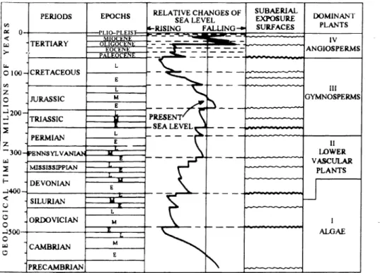
0.001 BED 0.01Fig. 1. Stratigraphic discontinuities and time gaps (ESTEBAN 1991)
Fig. 2. Idealized authigenic karst profile, not to scale (ESTEBAN and KLAPPA 1983) UPPER Dissolution, biological corrosion Moon-milk deposits
Infiltration zone
Percolation zone
Perched water-table
Precipitation Speleothems
Capillary fringe UPPER Dissolution and
hydraulic erosion Cave sediments
Increasing hydrostatic pressure LOWER Lenticular zone
The development of the main palaeokarst stages is presented in Fig. 3 (according to ESTEBAN 1988).
Finally, evaluating the facies of the wall rock and the palaeokarst in accordance with ESTEBAN and KLAPPA (1983) and WRIGHT (1988) we focus on the close relation between palaeokarstiflcation and global eustatic sea level changes (Fig. 4).
Dealing with the morphology of palaeokarsts we concentrate on features con
trolled by bedding plane and by tectonism, and on their combination. Accordingly we distinguish conformable (parallel with the bedding) and disconformable (cutting the bedding) and the combination of conformable-disconformable types. By analysing the connection between morphology and facies it is possible to make certain simpli
fications and say that the conformable elements are characteristic primarily of the phreatic levels, while disconformable elements occur mainly in vadose levels. Since most palaeokarst systems contain both conformable and disconformable elements, they cannot, in themselves, be used mechanically in genetical and facies analysis.
The infilling sediments of palaeokarst are characterised by extreme lithological, genetic and facies variability. As a result, their general classification (Fig. 5) —in our opinion— is a task almost impossible to solve.
Diagnostic criteria for palaeokarsts are happened to be different clayey palaeosols and caliche profiles. A detailed description of the latter is given by ESTEBAN and KLAPPA (1983).
Syn-depositional and diagenetic phenomena are regarded as a complicated sys
tem of porosity forming and infilling processes, changing constantly in time and space (Fig. 6). Here we call attention again to the definition of karst as a proper “dia
genetic facies” by ESTEBAN and KLAPPA (1983, p. 11). It seems to be justifiable to use their definition in a wider sense: thus we can state that the initial palaeokarst may have played a decisive role in the syngenetic and early diagenetic processes of peritidal carbonates. These processes take place in the vadose (meteoric), oscillation (transitional) and shallow phreatic zones, partly under subaerial conditions and some of them at shallow burial depths. Some diagenetic processes also operate at greater burial depths, in the deep phreatic zone. Both in the syn-diagenetic and in late dia
genetic phases thermal effects cannot be excluded, and palaeokarst horizons having entered deep diagenetic zones earlier, may get into subaerial conditions again. Thus the reconstruction of diagenetic history is bound to be an extremely hard task.
Fig. 3. Stages of karst evolution (ESTEBAN 1988)
Fig. 4. Relative global sea level changes, major known subaerial exposure surfaces and dominant plant groups during Phanerozoic time (ESTEBAN and KLAPPA 1983)
ALLOCHTHONOUS CLASTIC
i) FLUVIAL — many kinds — predominantly allochthonous 2) DEJECTA CONES, COLLUVIUM and MUDFLOWS — common 3) FILTRATES — cones of fines from seepage; minor in volume 4) LACUSTRINE — rare; clays, silts and fine sands
5) MARINE — rare; beach facies at entrances 6) EOLIAN — normally minor to negligible
7) GLACIAL and GLACIO-FLUVIAL INJECTA — common in glaciated areas 8) SUBGLACIAL LACUSTRINE — often varve-like
ORGANIC
9) FLUVIAL OR EOLIAN TRANSPORTED — from tree trunks to spores 10) CAVE-USING EXTERIOR FAUNA — bones, nests and middens, faeces AUTOCHTHONOUS CLASTIC
i d BREAKDOWN
12) FLUVIAL — derived from breakdown 13) WEATHERING RINDS and EARTHS 14) EOLIAN — derivates of all the above deposits PRECIPITATES and EVAPORITES
More than 100 secondary minerals form in caves PREDOMINANT ARE:
15) CALCITE — most significant
16) OTHER CARBONATES, HYDRATED CARBONATES 17) SULFATES, HYDRATED SULFATES, HALIDES 18) PHOSPHATES and NITRATES
19) SILICA and SILICATES 20) ORE ASSOCIATED MINERALS
21) ICE — as glacial injecta, glaciers, water ice, frost ORGANICS
22) TRACKS and REMAINS CAVE ADAPTED (HYPOGEAN) and PHREATOPHYTE FAUNA
Fig. 5. Cave interior deposits (FORD 1988)
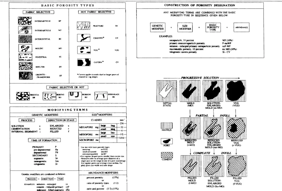
Fig. 6. Classification of pores and pore systems in carbonate rocks (CHOQUETTE and PRAY 1970)
In the classification of palaeokarsts, genetic, geographic, morphological, climat
ic and tectonic criteria play important roles individually or combined with each other.
Some genetic classifications may be governed by authigenic or allogenic recharge (JAKUCS 1977), by stages in development (early, juvenile, mature, senile), by tem
perature of solutions producing karstification (e.g. thermal or hydrothermal karsts), by the relation between karstic features and the surface (e.g. covered, uncovered, exhumed karsts) and in some cases by the grade of the conservation of karsts (e.g.
relict karsts). In geographic classifications the present morphological position (e.g.
coastal karst, continental and alpine karst) or even geographic name of characteristic occurrences (Dinarid-karst, South-Chinese tower karst, Cuban conekarst) is impor
tant. The guiding principle of morphologic classification may be the variety of char
acteristic forms (e.g. conekarst, tower karst), or in some cases the landscape where the karst occurs (cockpit karst). Climatic classification is based on the present loca
tion of karst occurrences within different climatic belts (tropical, mediterranean, tem
perate, arctic). In a tectonic classification the global position (e.g. craton or conti
nental platform areas, folded orogenic belts, island arcs) is a decisive factor or indi
vidual faults controlling the karst.
The description of thermal or hydrothermal karsts from Ordovician, Lower Carboniferous, Lower and Middle Triassic, and Upper Eocene formations (BOGACZ et al. 1970, BROWN 1970, ESTEBAN and KLAPPA 1983, SANGSTER 1988, MUSSMAN etal. 1988, KRAUS 1988, NÁDOR 1992at b, KLEB et al. 1993a) suggests that they are usually formed by fluids of 100-200 °C. We suggest individ
ual evaluation in deciding whether these are syngenetic or epigenetic.
In connection with analysis of palaeokarsts and tectonics as well as of unconfor
mities (discontinuities) we stress again their tectonic control. The megatectonic con
ditions together with other (predominantly climatic) factors, are of decisive impor
tance in the formation and development of palaeokarsts. It is an interesting phenom
enon that palaeokarsts of continental platforms and of island arc areas are almost identical. In our opinion this indicates similar conditions of formation, despite the great difference in geologic-tectonic position. The important role of the linear tec
tonic control in the formation and development of palaeokarsts has long been known and generally accepted. In spite of that, until now there has been little attention paid to microtectonics as a diagnostic criterion in the early syn-diagenetic phase of palaeokarstification.
Unconformities (discontinuities) indicating a break in shallow marine cyclic car
bonate sedimentation have been known for a long time from the work of FISCHER (1964) and their facies interpretation is universally accepted. Attention to the impor
tant role of unconformities in the formation and recognition of palaeokarsts was called by ESTEBAN and KLAPPA (1983). DESROCHERS and JAMES (1988), ESTEBAN (1988). KORPÁS and ITURRALDE VINENT (1992) JUHÁSZ et al. (1995), who stressed their close genetic relation with tectonics and eustatic sea level changes.
One of the most important practical aims in palaeokarst research is the estimation of porosity, i.e. of determining the location and grade of their reservoir potential.
Porosity evolution at different palaeokarst stages, as well as in vertical profile are presented on Figs. 3 and 7. On the basis of these we conclude that from point of view of porosity evolution:
— the most favourable stages are found in juvenile and mature karst,
— the most favourable facies are the upper part of the phreatic zone, the transi
tional zone between the phreatic and vadose zones as well as the lower part of the vadose zone.
Here we would like to call attention to the case study and excellent genetic model by CRAIG (1988) which analyses the conditions of the palaeokarstic reservoir of the Upper Permian San Andres dolomite in Yates Field, West Texas.
The diagnostic criteria of palaeokarsts mostly consist of indirect, and, in smaller portion of direct elements. This is easy to understand because those should be select
ed from among the general criteria of karsts which prove their “palaeo" nature. From among the criteria listed by ESTEBAN and KLAPPA (1983) and CHOQUETTE and JAMES (1988) those are selected here which are specially valid for palaeokarsts:
— sequences shallowing upward with rapid wedging-outs and truncations in them,
— cyclic unconformity (discontinuity) surfaces dividing the sequences,
— authigenic/allogenic as well as monomictic/polymictic elastics connected with these,
— tepee structures and other in situ, often conformable sedimentary breccias,
— caliche facies,
— the occurrence of terra rossas and other palaeosols,
— desiccation phenomena,
— the presence of gravitational meniscus (vadose) cement,
— missing palaeontological zones.
To complete the list we would suggest to add tectonic dislocations between two discontinuity surfaces, as well as synsedimentary microtectonic phenomena produc
ing infillings. It is an interesting fact, that no mention is made of these in the cited works.
POROSITY
PERMEABILITY EVOLUTION STAGES
Fig. 7. Karst evolution stages and porosity-permeability in vertical section (ESTEBAN 1988)
Geological models of palaeokarsts
The theoretical model of the entire karst system as drawn up by FORD (1988) is presented in Fig. 8. Since in the above model palaeokarst profiles may appear any
where, we will concentrate on those models which describe karstification near to sea level. Using the figures of ESTEBAN and KLAPPA (1983) we present the zonation of exposed coastal surfaces of recent rocky shores and sediment shores (Fig. 9). The further development of the above mentioned exposure surfaces in connection with sea level rise or fall is shown (Fig. 10). As a next step in the interpretation of the cited pro
files, we analyse them as a dynamic evolution intersected by sea level changes of dif
ferent order. In this way the coastal palaeokarst profiles of recent and Pliocene-Pleistocene examples were formed, which are known from the Bahamas (RASMUSSEN and NEUMANN 1988), from the Bermudas (BRETZ 1960, VACH- ER 1978), from Florida (DODD and SIEMENS 1971, ENOS and PERKINS 1979) and from Barbados (JAMES 1972, ALLAN and MATHEWS 1977). On the basis of this we do not consider it accidental, that the palaeokarst models drawn up in the rel- 16
1.3.
Fig. 8. The comprehensive karst system (FORD 1988)
Fig. 9. Schematic cross-section of coastal surfaces (ESTEBAN and KLAPPA 1983) a) common zonation across present-day rocky shores b) main features across present-day sedimentary
shores
Fig. 10 Major pathways of evolution of exposure surfaces (ESTEBAN and KLAPPA 1983)
Fig. 11. General elements and hydrology of karst terrain developed along the sea (CHOQUETTE and JAMES 1988)
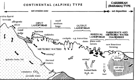
Fig. 12. Caribbean karst model (ESTEBAN 1988, after JAMES and CHOQUETTE 1984)
evant literature describe essentially present-day coastal conditions. We present more general examples, valid both for continental margins and for islands (Figs. 11,12) too.
Models similar to those above were applied by CRAIG (1988, p. 360, Fig. 16/16) in the genetic analysis of the Upper Permian San Andres dolomite reservoir in West Texas, as well as by MINERO (1988, p. 393, Fig. 18/4) in the reconstruction of the palaeokarst of the Middle Cretaceous El Abra Formation in Mexico.
It is notable that although all the coastal palaeokarst models presented outline the palaeohydrologic conditions and zonation, we have come across only one example of the analysis of proper hydrologic conditions. VACHER (1978), on the Bermudas, investigated by means of a well-monitoring system the position of the Ghyben- Herzberg lens, (providing the drinking water for the inhabitants), its transitional and mixing zone, and the systematic changes of water table (p. 208, Fig. 1. p. 209, Fig.
2, p. 215, Fig. 4, p. 218, Fig. 5).
From literature and our observations (KORPÁS 1988, KORPÁS and MUR- RALDE VINENT 1992, JUHÁSZ et al. 1995), we have come to the conclusion that the early phase of palaeokarstification must have taken place in a marine environ
ment, in a position near sea level. Our opinion is that the great variety of forms char-
Conclusions 1.4.
acteristic of the juvenile and mature phases of palaeokarsts, in addition to the mixing corrosion in the coastal phreatic and vadose facies zone, mechanical and bioerosion have a significant role to play. Mechanical erosion —waves, tidal movements, stormtides and the earth tidal pump— has an extremely quick and intensive effect especially in places weakened by tectonics and bioerosion1.
The proposed palaeokarst model (Fig. 13.) contains essentially few new elements as compared to previous ones. Drawing it up we considered the basic principle that palaeokarstification, in its entirety, is the result of processes accompanied by relative sea level changes. This can be caused by eustatic sea level changes or by tectonic fac-
Fig. 13. Regressive terrace model of palaeokarsts (KORPÁS and JUHÁSZ 1993) 1. reef and reefal sediments, 2. lagoon sediments, 3. supratidal sediments, 4. karst levels
(vadose/phreatic)
1 The role of bioerosion in karstification is recognized by all authors quoted in this work, but they write cautiously about its extent and significance. Studies dealing with bioerosion and trace fossils (HODGKINS 1964, NEUMANN 1966 in WARME 1975, GOLUBIC et al. 1975, BROMLEY 1975, CRIMES 1975, SCHNEIDER 1976) indicate that this effect is most intense in the subtidal, tidal and supratidal zones. The significance of bioerosion lies not so much in the rates of erosion, calculated in some cases (Australia, HODGKINS 1964, 1 mm/year, Bermudas, NEUMANN 1966, 14 mm/year) as in the preparation of the substrate for mechan
ical erosion and mixing corrosion. CRIMES (1975, p. 118. Fig. 7/2.) publishes a synoptic facies diagram of trace fossils "participating" in bioerosion, and especially the part referring to palaeokarstification along rocky and sedimentary shore is instructive from our point of view.
tors, or by the combination of both (ESTEBAN and KLAPPA 1983, DESROCHERS and JAMES 1988, WRIGHT 1988).
Considering this, the following criteria were applied to the proposed model:
— sedimentological criteria: taken in its complexity the facies of the carbonate wall rock in palaeokarst profiles is regressive. This means that in sequences shal
lowing upward, regressive migration of standard carbonate facies belts is to be expected according to the trend in Fig. 13. The sequence boundaries coincide with the third-order discontinuity (palaeokarst) surfaces,
— tectonic and/or climatic criteria: the trend outlined above is the outcome of periodic rises and/or falls of base-level resulting from regional tectonic processes and/or sudden sea level changes,
— tectonic criteria: periodic and terrace forming emergence by all probability takes place in stages, starting from outer shelf margins and produces a littoral karst plain or tidal flat of varying width (some 100 m — some km).
The novelties of the model presented for the interpretation of palaeokarst evolu
tion are the following:
— it associates phreatic cave levels with former sea levels,
— it attributes a significant role in the karstification of phreatic levels to mechan
ical erosion brought about by whirling and turbulent seawater in the system,
— it provides an acceptable explanation for the gradual wedging-outs of phreat
ic levels, working towards predetermined direction (windward side coasts),
— it relates the original terrace to the palaeokarst levels, partially built one upon the other.
Exploration strategies and methods of study
The exploration strategies applied to palaeokarst systems are defined by the rational exploration, use and explotation of their natural and mineral potential.
Therefore, during the evaluation of this potential it seems to be primordial to estimate whether the palaeokarst systems should serve only like reservoirs and traps for this potential, or whether they are in close genetic relationship to each other. In the first case (oil, karst and thermal waters) it seems to be sufficient to determine the main conduit zones and the reservoir potential. The second possibility requires the genet
ic analysis of both the palaeokarst systems and their solid mineral potential. Taking into consideration that it is impossible to develop an exploration strategy aimed both for general and for specific objects, we had to stop at a point where the specific eval
uation of palaeokarst systems for mineral deposits begins (Table 3).
Table 3 Exploration strategies (after ESTEBAN 1988)
An understanding of the genesis of palaeokarst systems requires an integrated approach to their study (Table 4).
I. Unconformities
A) Their importance in exploration B) Unconformities and palaeokarsts II. Karst systems
A) Modern karsts 1. Karst and lithology 2. Porosity
3. Karst facies
4. G enesis and evolution o f karst system s
B) Palaeokarst facies and genesis 1. Main facies
2. Characteristics o f palaeokarst facies in outcrops, in drilling cores, in polished sections, in well log and in seism ic profiles
3. Analysis of the palaeokarst facies (mineralogy, petrology, geochemistry, stratigraphy, palaeontology, microtectonics, physics and geophysics)
4. Palaeokarst profiles and porosity dis
tribution
5. Genesis, evolution and 3D models III. Palaeokarst and its natural potential
1. Petroleum
2. Karst and thermal water 3. Bauxite
4. Lead and zinc ores 5. Uranium ores 6. Manganese ores 7. Phosphates 8. Nitrates 1.5.
Table 4 Methods of study
1. Sampling (exposures, caves, mining tunels, drilling cores) 2. Methods of investigation
— Mineralogy and petrology (microfacies, mineral phases, diagenesis, fluid and gas inclusions, vitrinite reflectance)
— Geochemistry (major and indicator elements, stable isotopes of Ol8/C13, radiometric age determinations)
— Palaeontology (age and facies)
— Stratigraphy (magnetostratigraphy, sequence stratigraphy)
— Microtectonic survey
— Physical parameters and geophysical properties (porosity and permeability, well log analysis, seismic reflexion survey)
2
. Worldwide examples
2.1. Bahamas
Geological setting
The Little Bahama Bank represents the second largest of the carbonate banks which constitute the Bahamas. It consists of young Mesozoic and Tertiary platform carbonates and platform margin sediments, with a thickness of 5000-6000 m covered by 30-40 m of Pleistocene and Holocene eolianites, oolite shoals and lagoonal deposits with palaeosols (HINE and NEUMANN 1977, RASMUSSEN and NEU
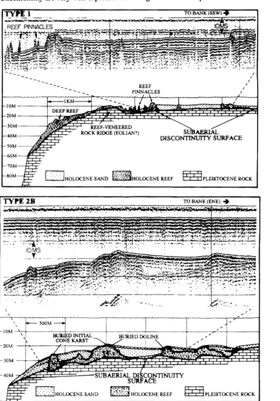
MANN, 1988). The entire section is dissected by cave systems, and is bounded to several discontinuity surfaces, giving it a “honeycombed” architecture (BEACH and GINSBURG 1980). Two main discontinuity surfaces are exposed by boreholes and seismic surveys (Figs. 14,15). The first one is located some meters below sea level, at the base of the partly soft modem sediments. The second one represents the com
posite, partly subaerial unconformity surface between the Holocene and Pleistocene sediments, at a depth of 20-45 m below sea level.
Palaeokarst interpretation
The profiles (Figs. 14, 15) represent excellent examples of windward shelf and shelf margin sections, located along the rimmed carbonate platform of the Bahamas.
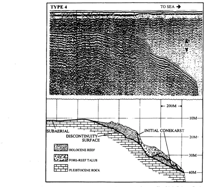
The deposition of the Holocene fringing reef complexes started about 10,6 ky ago (HINE and NEUMANN 1977) and continuous sea level rise has resulted in the for
mation of dissected reefs and reef pinnacles. The depressions between the individual reefs were filled partly by lagoonal deposits, partly by reef talus breccias. It is note
worthy, that the morphology and the sizes of these individual reefs correspond to the morphology and sizes of cone and tower karsts. The dimensions of the back reef lagoons are very similar to those of dolines, while the reef talus breccia found in depressions, using karst-terms, seems to be a collapse breccia. The entire palaeokarst profile is covered by very young sediments (3,6 ky to present in age) and is located below sea level.
2.2. Gulf of Mexico (West Florida, Campeche Bank-Mexico) Geological setting
The 12-16 km thick platform sequence, accumulated at the southern border of the North American Craton consists of the following main lithological complexes (VINIEGRA 1971, MEYERHOFF and HATTEN 1974, SHERIDAN et al. 1981):
— Middle Triassic-Late Jurassic fluvial-delta-deltafront and prodelta elastics, deposited on platform and platform margin areas (2000-5000 m).
— Late Jurassic-Early Cretaceous evaporites (4000 m).
— Late Jurassic-Early Cretaceous platform margin carbonates (1000 m).
— Early Cretaceous-Tertiary platform carbonates, slope and intraplatform basin sediments (5000-6000 m).
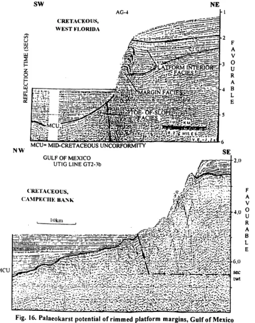
In the evolution of the Early Cretaceous-Tertiary carbonate platform the Mid- Cretaceous Unconformity has an outstanding role (MEYERHOFF and HATTEN 1974). This unconformity separates the carbonate platform in the West, bordered by fringing reef complexes (Yucatan, Campeche Bank, Jordan Knoll, West Cuba, 22
Florida), from the intraplatform basin filled with pelagic sediments in the East of the Gulf of Mexico. The Cretaceous carbonate platform sequence is the main reservoir of the Mexican onshore (Yucatan, Golden Lane, Póza Rica) and offshore (Campeche Bank) petroleum reserves. Therefore during the last two decades a great amount of seismic reflection data has been gathered throughout the Gulf of Mexico. Two emi
nent examples from West Florida and from the Campeche Bank are presented after SCHLAGER (1991) on Fig. 16. In spite of the great distance, the profiles reflect identical situations: the original boundary of a carbonate platform and that of an intraplatform basin at the base of the Albian. The carbonate platform margin, bor
dered by fringing reefs, and back-reef lagoonal units, the talus and the intraplatform basin, infilled by slope and pelagic sediments above the Mid-Cretaceous Unconformity are very well expressed on the right sides of both profiles.
Fig. 14. Palaeokarstic interpretation of rimmed platform profiles. Little Bahama Bank (after HINE and NEUMANN 1977)
Fig. 15. Palaeokarstic interpretation of rimmed platform profiles, Little Bahama Bank (after HINE and NEUMANN 1977)
Palaeokarst interpretation
The seismic profiles show the internal architecture of the Cretaceous carbonate platform bordered by fringing reefs, dissected by master discontinuity surfaces and covered by pelagic sediments at the top (2.0 and 2.5 sec). The evolution and the growth of the Cretaceous carbonate platform are practically identical to recent exam
ples of the Bahamas (Figs. 14, 15). The single, but great difference is in the scale.
The Cretaceous profiles of West Florida and Campeche Bank represent an about 2500-3000 m thick complex, similar to those of the recent, some ten meter thick, of the Little Bahama Bank. Consequently the palaeokarstic reservoir potential of the Cretaceous platform is much greater.
2.3. Cuba
Regional geology and evolution
Cuba, as an accretionary grown neoplatform area is located at the southern border of the North American continental plate, separated from the oceanic Caribbean plate by the large scale Motagua-Cayman synistral fault (CASE et al. 1984, PINDELL 1991).
Its geological structure is illustrated after KORPÁS (1988) on Figs. 17, 18, briefly describing the following main phases of its geological evolution:
1. Ancient platform stage (>230 Ma).
2. Early rifting stage (7210-160 Ma) and opening of the oceanic basin (160-140 Ma).
3. First island arc stage (140-75 Ma) with its early (140-90 Ma) and late, mature phases (90-75 Ma), closed with back arc rifting (75-50 Ma).
First collision and obduction (70-45 Ma).
Second collision and obduction (40-25 Ma).
4. Neoplatform and second island arc stages (75-45 Ma) with its early (75-55 Ma) and late, mature phases (55-45 Ma), fol
lowed by a back arc rifting (40 Ma to present).
5. Modern accretionary neoplatform stage (45 Ma to present) with the closing of the oceanic basins (45-30 Ma) and with formation of the neoplatform (30 Ma to present).
The tectono-stratigraphic analysis of the Cuban formations resulted in the evalu
ation of the palaeokarst potential of Cuba (Fig. 18). The estimated 15 main palaeokarstic horizons have a good correlation with the principal unconformities and coincide with the main global, eustatic sea level drops (HAQ et al. 1987).
Two examples of the Cuban palaeokarst will be described in the following (after KORPÁS and ITURRALDE VINENT 1992).
Pan de Guajaibon, West Cuba The Upper Aibian/Cenomanian diaspore bauxite deposits are a classical example
of palaeokarst in Cuba (Fig. 19). Their detailed description is given by RAZU- MOVSKIY et al. (1987) and only the major palaeokarst patterns are cited here.
Within the peritidal and shallowing upward Guajaibon formation, karstification and oolitic bauxites are related to a 3rd order syntectonic unconformity. Diagnostic crite
ria worth mentioning are the following: shallowing upward cycles, early dolomitiza- tion in the bauxite footwall, pedogenetic features, subaerial exposure surface and
Fig. 16. Palaeokarst potential of rimmed platform margins, Gulf of Mexico (after SCHLAGER 1991)
Fig. 17. Geological evolution of Cuba (KORPÁS 1988)
1. Clastics. 2. Evaporites. 3. Clastics and carbonates. 4. Carbonates. 5. Carbonates and silicites. 6. Volcanogen and sedimen
tary elastics. 7. Effusives. 8. Intrusives. 9. Continental crust. 10. Oceanic crust. 11. Upper mantle. 12. Relatív plate motion.
13. Faults. — 1= Continent, 1.1. = Intracontinental sea, 2. = Continental units N, 2.1. = Bahama platform, 2.2. = Continental slope, 3. = Abyssic plain, 4. = Mid-oceanic ridge, 5. = Continental units S, 5.1. = Platform S, 5.2. = Continental slope, 6. = Back arc basin, 7. = Volcanic arc Zaza (J,-Cr2), 8. = Fore arc basin, 9. = Accretionary prism, 10. = Back arc basin, 11. = Cr, intrusives, 12. = Volcanic arc Cauto (Cr2-E2), 13. = Accretionary prism, 14. = Accretionary neoplatform I, 14.1. = Residual basins, 15. = E,_2 intrusives, 16. = Accretionary neoplatform II, 16.1. = Residual basins, 17. = Southern continental slope and abyssic plain, 18. = Composite accretionary neoplatform I+II, 18.1. = Closed residual basins, 19. = Northern continental slope
and abyssic plain
W EST CUBA CEN TRA L CUBA EAST CUBA P A L K .O k A R S T K HORIZONS
COASTAL ON LAP CURVES
1 2 3 4 5 1 2 3 4 6 1 2 3 4 5 1 2 3 4 6 1 2 3 4 5 1 2 3 4 6
STACKS 01 FVOC
CENOZOIC
Q U A T E R N A R Y
1 MODERN PLATFORM STACK| 2ND SUBSTACkI
neogene|
1
UPPERI
LOWERu
UPPER I 1ST SUBSTAtIK|IK E> MIDDLE
£
LOWERP A I. E O G E N F GO- 2JLUPPER
E
LOWER<K UPPERme:
MIDDLE
QUASIPLATFORM AND 2ND ISLAND ARC STAGE
LOWER
a
UPPER[pal |CE>LOWER
MESOZOIC C K E 1 A C E O l S
MAASIIL CAMPANIAN 2
z
7.
\r.
SAN ION IAN CONI AC LAN Tl ROMAN CENOMAN.
ALIHAN APTIAN U] BARREN! IAN O 11 ALTERIN'.
—J VAI ANGIN.
BERKIASIAN
.11R A S S I C
s TITHONIAN
< klMMFRIIX;.
EARLY RIFTING STAGE
OXFORDIAN X
XX
LIASI
TRTASSIC i - 1 3* o
S 3 ANCIENT PLATFORM VIAtlK
Fig. 18. Tectonostratigraphic chart of Cuba and related palaeokarst horizons
Fig. 19. Albian/Cenomanian palaeokarst horizon, Pan de Guajaibon, West Cuba (KORPÁS and ITURRALDE VINENT 1992, after RASUMOVSKIY et al. 1987) 1. Limestones, dolomites; 2. Limestones; 3. Bauxites; 4. Gravelites; 5. Sandstones; 6. Mudstones:
7. Quaternary sediments; 8. Normal and reverse faults; 9. Boreholes; 10. Guajaibon Formation:
11. Parasequence boundary
Fig. 20. Palaeokarst section in Punta Caleta, East Cuba, not to scale (KORPÁS and ITURRALDE VINENT 1992, after MARRERO 1951 and NAGY et al. 1983)
bauxite formation, monomictic-polymictic elastics with onlap contact in the hanging wall of the bauxites.
As an excellently described palaeokarst analogy the El Abra Formation in Mexico (MINERO 1988) can be cited.
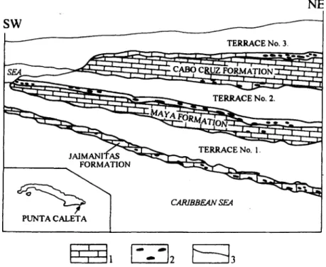
Punta Maisi-Punta Caleta, East Cuba A good example for the regressive terrace model (KORPÁS and JUHÁSZ 1993)
can be found at Punta Maisi-Punta Caleta section in East Cuba, composed of 5-11 terraces and corresponding erosion surfaces (Fig. 20). Sporadic observations (FRANCO 1983, BREZSNYÁNSZKY et al. 1983, KORPÁS 1988) concerning diagnostic criteria for palaeokarst are the following: shows of bauxites and related palaeosols, early dolomitization and intercalations of monomictic-polymictic elas
tics. The shallowing upward trend can be recognized in the parasequence order of the intensively karstified peritidal limestone formations as well: Middle-Upper Miocene of Cabo Cruz, Upper Miocene-Pliocene of Maya and Quaternary to Present of the Jaimanitas. The tectonically controlled palaeokarst is overprinted by 3rd to 5th order high frequency sea level changes.
England Geological setting The Lower Carboniferous (Mississippian) carbonate ramp section bearing
palaeokarst horizons in England (Fig. 21) will be discussed after WRIGHT (1988).
The 35-45 m thick section of the quarry of Chipping Sodbury in the vicinity of Bristol displays the following:
— 10 m of parallel, slightly undulating bedded, oolitic grainstone (Gully oolite) rich in brachiopods, crinoids, containing rootprints and burrows. Millimetre thin joint system with red mudstone and calcite infillings and some, 3 m long, narrow V-like dissolutional pipes (Photo 1). The last ones are perpendicular to the bedding and they are infilled with early, marine, laminated mudstones and grainstones. The shallowing upward section is completed at the top by a bedding plane parallel and slightly irreg
ular discontinuity surface.
— Discontinuity surface.
— 2-5 m thick, flat lens of crystalline dolomites with mud cracks. They are early, mixing zone dolomites with slight meteoric influence.
— 8-10 m of oolitic peritidal limestone and dolomites.
— Subaerial discontinuity surface.
— 12-15 m of clastic sequence: alternation of well developed, nodular, brecciat- ed calcrete horizons (4-5 m) with medium grained, cemented, fluvial sandstones (1-2 m) The calcretes are a rhizocretion type, containing mud cracks and show a very fine joint network, infilled by dolomite and calcite.
— More than 3 m of subtidal limestones and dolomites with 5 stromatolite bear
ing horizons at the base.
2.4.
Fig. 21. Simplified cross-section of Early Carboniferous ramp in South Wales (WRIGHT 1988)
29
Palaeokarst interpretation
The exposed profile, as part of a homoclinal ramp sequence (WRIGHT 1988) consists of two, shallowing upward complexes, interrupted by two discontinuity sur
faces and covered by subtidal carbonates at the top. Diagnostic criteria for palaeokarst: shallowing upward cycles, calcrete horizons, early mixing zone dolomites, mud cracks, dissolutional features and early marine laminite infillings, discontinuity surfaces. The first cycle of the Gully oolite represents a landward mov
ing, shallow oolite shoal system. The sudden end of deposition of the oolites is indi
cated by the first discontinuity surface and by the opening of the V-like, narrow fis
sures. This part of the section does not show any proof for subaerial exposure and the early marine laminite infillings indicate shallow marine environment, with a maxi
mum depth at wave base. The mixing zone dolomites with mud cracks above the first discontinuity surface show the starting of the second shallowing upward cycle in per- itidal conditions. That was completed by the second, already subaerial discontinuity surface at the bottom of the first calcrete horizon. The third cycle is represented by alternation of the calcrete horizons with fluvial sediments. This means a rapid change in the depositional environment, i.e. the ramp was covered by the prograding silici- clastic lobe of river(s). The final submergence of this Caribbean type palaeokarst is indicated by the deposition of the stromatolite bearing fourth cycle of subtidal lime
stones and dolomites.
Spain
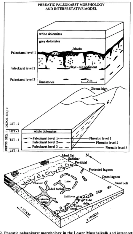
Catalan Range Geological setting
The 230-300 m thick, rift related Middle Triassic Muschelkalk, as a homoclinal ramp-sequence in the Catalan Range will be discussed after CALVET et al. (1990) and CALVET and TUCKER (1995). The lower and upper units of these platform car
bonates are separated by the Middle Muschelkalk evaporites and marls. The Lower Muschelkalk represents a broad, transgressive sequence, from peritidaT(El Brull Formation) to lagoonal (Olesa Formation) and to sand shoal (Vilella Baixa Formation) environments. These facies are capped by a regional subaerial disconfor- mity surface and related multiple palaeokarst horizon (Fig. 22). This latter one is covered by the intertidal-supratidal-sabkha dolomites of the Colldeju Formation.
The Upper Muschelkalk consists of tidal, lagoonal and outer ramp sediments (Rojals oolites, Benifallet Formation) covered by the Querol stromatolites and by the La Riba mud mound-reef complex. The deposition of the stromatolite and reef units was terminated by another regional subaerial exposure, resulting in the formation of a new palaeokarst horizon, covered completely by the Alcover dolomites.
Palaeokarst interpretation
The palaeokarst horizons as sequence boundaries indicate a relative sea-level fall, in the magnitude of 50 m, and their estimated ages are: 238 Ma and 235 Ma (CAL
VET et al. 1990, CALVET and TUCKER 1995).
The brief description of the composite multiple palaeokarst horizon of the Lower Muschelkalk is cited according to CALVET et al. (1990):
“The main palaeokarst level has a morphology of horizontal cavities from a few centimetres to more than 3 m in height and from a few metres to more than 100 m in length. The cavities are filled by clays and silts, red to brown in colour, with cen
timetre-decimetre angular blocks from cave-roof collapse. The surface morphology is smooth to angular. A vuggy porosity occurs in the carbonates close to the main palaeokarst horizons. The cavities are interpreted as caves developed in meteoric-phreatic environment.”
One section of this palaeokarst horizon, suggested as a flat doline is shown on Photo 2.
2.5.2. Mediterranean coast
,
Cap SalouGeological setting
One of the best examples of composite palaeokarst, related to a regional uncon
formity in platform sequences is described by SALAS. (1990) from the Catalan Coastal Range, near Tarragona (Fig. 23, Photo 3). Middle and Late Jurassic platform dolomites, with a thickness of a few 100 m developed in onshore and offshore areas and consist of massive, brecciated and bedded-laminated types of rock. The 30
2.5.
2.5.1.