E COCYCLES Scientific journal of the
ISSN 2416-2140
European Ecocycles Society
Ecocycles, Vol. 7, No. 1, pp. 52-72 (2021) DOI: 10.19040/ecocycles.v7i1.191
RESEARCH ARTICLE
Living with Water: Infrastructure and Urbanism in Jakarta
John Napier
John Napier Architect, London E-mail address: jdnapier1@yahoo.co.uk
Abstract – Cities around the world are at risk of pluvial and fluvial flooding, due to more frequent extreme weather events and uncontrolled urbanisation. Coastal cities are additionally at risk from tidal flooding and sea level rise. Hard surface infrastructure leads to rapid storm-water run off overwhelming conventional drainage systems at peak times. This article examines what constitutes infrastructure in the 21st century and what should its new priorities be?
A case study is made of Jakarta, a low lying delta city, where the consequences of unregulated economic development are starting to be addressed. The lack of a city based water supply has led to excessive ground water extraction and the sinking of the city further exacerbating flood risk. City wide flooding has occurred three times in the last 15 years.
Water needs to be considered as a primary element in infrastructure strategy and space found for natural systems and active travel. In Jakarta the role of the kampungs (informal settlements) provides an opportunity to address social and environmental difficulties at the same time.
This interdisciplinary overview analyses recent infrastructure initiatives and developments and asks what more can be done and what new planning policies and concepts may be required.
Key words - pluvial flooding, fluvial flooding, storm-water attenuation, wetlands, Jakarta, inclusive development, soft infrastructure, green/blue urbanism, kampung
Received: June 19, 2021 Accepted: August 6, 2021
INTRODUCTION
Cities are around the world are at threat from the increasing frequency and severity of extreme weather events and in particular from flooding from fluvial (river) and pluvial (surface water runoff) flooding. Hard surfaces and expanding urbanisation together with deforestation in the uplands contribute to the tendency of existing drainage systems to be overwhelmed. Coastal cities are additionally under threat from higher tides and the acceleration of sea level rise as Arctic and Antarctic ice sheets melt. It is estimated that: -
‘… by 2030, 15 million people and $177 billion in urban property will be impacted annually by coastal flooding, while 132 million people and $535 billion in urban property will be impacted annually due to riverine flooding.’ (World Resources Institute, 2020)
This article examines the causes and the dynamics of flooding in a rapidly expanding coastal megacity, focusing primarily on fluvial and pluvial flooding and seeks to give a renewed priority to the management of water in the design of the city.
A case study is made of Jakarta, Indonesia, a city in the
forefront of climatic and environmental risk; the intention is that a clearer view can be made not only of the specific city but of flooding and urbanism in general.
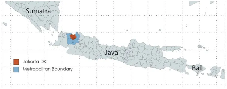
Figure 1. South East Asia, Indonesia and Jakarta.
Jakarta is the central city of Indonesia and has been its capital since Indonesia’s declaration of independence (from both the Dutch and the Japanese) in 1945. It sits at the west of Java island, which is the mostly highly populated and highly urbanised of Indonesia’s 13,000 islands (see Figures 1 and 2). It is 6 degrees South of the Equator).
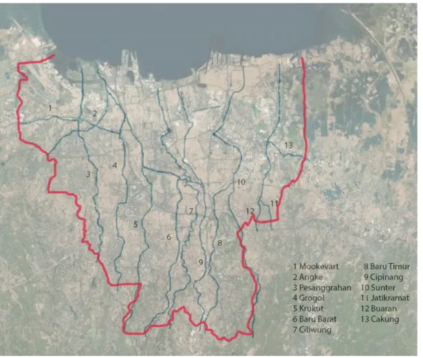
In Figure 2 the red colour indicates the boundary of the city’s authority, whereas the metropolitan boundary is shown is blue. Urbanisation has spread well beyond the red boundary, now occupying most of the blue region. The city itself sits astride a delta into which 13 rivers flow (see Figure 3).
Figure 2. The island of Java, showing the location of Jakarta.
Figure 3. Jakarta DKI boundary with 13 rivers.
The city has suffered catastrophic floods three times in 15 years and regular flooding compounds multiple environmental problems, economic inequality and extreme traffic congestion. In attempting a coherent understanding of the problems of the city, the author who has lived and worked in the city as well as being a frequent visitor, highlights flooding and water management as a fundamental urban issue of the new century, solutions to which have many related benefits. Water is seen as a resource the demand for which is more consistent than its supply.
1.1MAJOR FOOD EVENTS
Major flood events occurred in 2007, 2013 and 2014, all of which were induced by rain and led to river and flash flooding. The city is at risk from tidal flooding, especially because of its land subsidence, however a major tidal flood has not recently been faced by the city.
The flood in 2007 was a 1:50 year flood event according to the available statistics, with 80 deaths, 420, 000 people displaced and loss of property of US $ 900 million (see Figure 4). The flood was due to extreme quantity of rain, deforestation and clogged waterways in the city (JBA Risk Management).
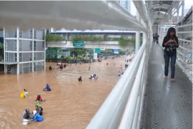
In 2013 heavy rain led to the collapse of a 50m length concrete wall to the West Flood Relief Canal causing serious flooding along several main roadways; the centre of the city (around Hotel Indonesia roundabout, see Figures 5 and 6) was brought to a standstill and loss of property was in the region of US$ 490 million (JBA Risk Management).
At the same time water levels in the Kampung Melayu / Bukit Duren area around the Ciliwung River rose by 5 meters from the level defined by the river banks (Rekittke, 2013, p88). The flood water was mixed with mud, solid waste and foul water. At these water levels emergency access is impossible and critical systems cannot function.
Larger building complexes have emergency generating sets but otherwise electrical power is unavailable.
In 2014 water levels of between 2m - 4m above normal were recorded along riverbanks, 23 deaths and a significant extent of low lying lands were underwater (JBA).
As 40 % of land within the Jakarta boundary is below sea level and land is sinking due to ground water extraction (JBA Risk Management), it is likely that despite remedial measures discussed below that flooding will continue to be a major risk across the city. As a regular feature of Jakarta life, river flooding is estimated to cost US$ 321 million per year (Budiyono et al 2015, Padawangi 2015).
On 31 December 2019, 377mm of rain fell in Jakarta in one day, the highest since records began in 1886. This caused flooding across the capital at the beginning of 2020, leading to at least 66 casualties (due to landslides, hypothermia, electrocution and drowning) and the displacement of approximately 400,000 people who sought refuge in shelters.
Figure 4. Flood in East Jakarta 2007.
Figure 5. The roundabout at Hotel Indonesia (Bundaran Hotel Indonesia) in January 2013.
Figure 6. A pedestrian bridge provides safe passage. Near Hotel Indonesia in January 2013.
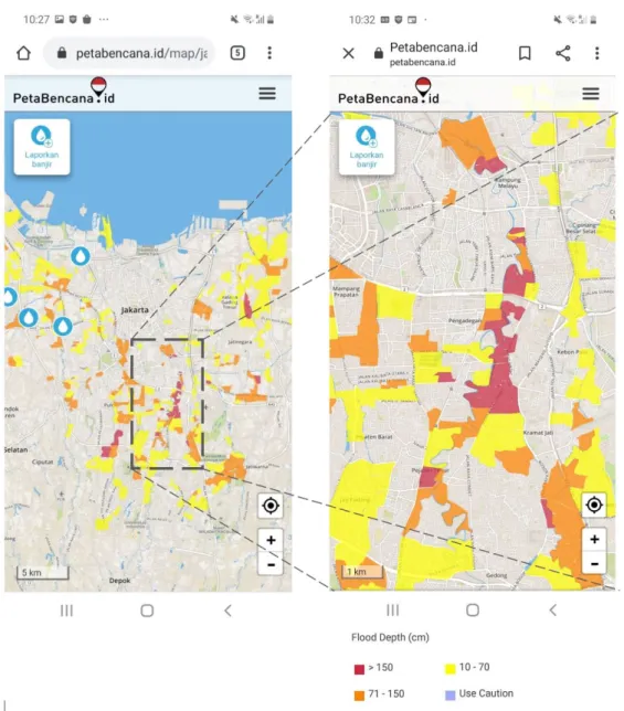
Areas of the capital not usually subject to flooding were inundated and reports indicate that flood levels of 4 metres and even 8 metres above ground level occurred. Many of the pumping stations which should pump floodwater to the sea were not in operation, many being overwhelmed by floodwater themselves (CNN, Economist, Time).
Mapped information and data about the flooding was able to be shared on an app on mobile phones (Petabencana); this is helpful for those seeking a safe haven. More often this data is helpful in planning a route to avoid local flooding.
Screenshots of the site on 2 January 2020 are shown in Figure 7.
2.0THE INFRASTRUCTURE OF CITIES
Infrastructure is the underlying structure (and collective support systems) that a city uses in order to work effectively (Cambridge Dictionary). This includes transport systems, power supplies, water supplies, sewage and rainwater systems and, more and more, digital communication systems.
A section of the United Nations Environment Programme’s Sustainable Development Goals reads: -
‘Target 9.1: Develop quality, reliable, sustainable and resilient infrastructure, including regional and transborder infrastructure, to support economic development and human well-being, with a focus on affordable and equitable access for all’ (UNEP).
For this type of goal to be achieved public and government leadership and goal setting is required; the goals may then be implemented within the private sector. Without this ad hoc and uncoordinated systems occur with little reference to wider goals and at the expense of civic life and natural systems.
A new paradigm of urbanism, green/ blue or ecological urbanism, is emerging which better integrates human systems with natural systems (Hagan (2015), Mostafavi et al (2016)). Within this paradigm the eco system services (for health and well-being, shade and cooling, flood attenuation) of trees and water are included as infrastructure. A new combination of hard and soft infrastructure will be sought in this article as a tool to better understand the case study city, Jakarta.
2.1RESILIENCE OF CITIES
‘Resilience’ is a lens through which environmental and economic risks of cities can be viewed. The concept of resilience can be used at many scales and in many disciplines. Urban Resilience is:-
‘the capacity of individuals, communities, institutions, businesses, and systems within a city to survive, adapt, and grow no matter what kinds of chronic stresses and acute shocks they experience.’ (Resilient Cities Network, 2021)
Figure 7. Flood Alert mapping, Jakarta mobile phone Screenshots from PetaBencana, 2 January 2020.
Study of the resilience of cities supports investment in infrastructure of mass rail transit, utilities generally and the reduction of environmental risks including those considered due to climate change.
The term ‘resilience’ is contested; the key question that researchers and practitioners should respond to is what kind of resilience is being discussed and for whom (Davoudi, 2012). Additionally, ‘resilience’ can be used as a vehicle for the displacement of communities in favour of apparently climate friendly development for very different stakeholders (Dawson A 2017 p 153 - 187). Also contested is whether a system should spring back to its original condition (the ‘classic’ engineering approach of static balance) or whether an ongoing and evolutionary dynamic should also be considered 'resilient'. In this article the focus is on life, critical systems and property for the full range of stakeholders in the city (Tyler, 2012).
2.2MOBILITY AND COMMUNICATION
Trade, team working and face to face meetings have driven the need for mobility across the city. Concentration of activity in a city centre or a combination of satellite centres and commuting either by train or by car has been a characteristic of the twentieth century city.
Infrastructure provision (with which water management is typically embedded) is led by the anticipated and projected needs of developments. A high priority for individual transport will require a high proportion of hard road surface (typically impermeable) with consequent implications for the capacity of the city’s drainage systems.
As cities moderate the priority they assign to individual transport, space can be designated for pedestrians, cyclists and landscape features such as trees. The success of this depends upon a support for public transport and potentially
on dispersed working arrangements supported by digital communication.
Transit Oriented Development promotes a higher density of building at transport nodes; this can be business led, retail led, housing led or a combination of these (Dunphy, 2003).
The benefit for the city is that car dependence can be much reduced and space can be set aside elsewhere for natural systems and amenities. The resulting spaces may be different from those celebrated by advocates of walkable cities which are typically based on traditional street patterns (Jacobs, 1993; Gehl, 2010). For example, pedestrian flow may be at more than one level and be independent of traffic.
Digital communication is accelerating worldwide, and together with the disruption caused by the Covid 19 pandemic, new ways of working and doing business are seen to be effective. Goods and services can be ordered without visiting a shop or office and team work can be achieved with more remote working. In Indonesia this is apparent in the success of the motor cycle courier hailing businesses such as Go-Jek (Palevsky 2019). Broadband and wireless systems are a leading component of the infrastructure required today.
These new forces reduce the emphasis which can and should be made on the hard infrastructure of roadways for the motor car.
2.3WATER IN THE CITY
Water and its flows links city making to nature’s systems, whether visibly or not.
Marine and river traffic influenced the historic siting of cities and towns next to water, these same places now find themselves at risk from flooding due to increased urbanisation, changing climate and potential sea level rise (Boshken 2012).
This is compounded by pluvial and fluvial flooding, where conventional drainage systems become overloaded. A summary of ground conditions from the hills to the sea highlights key issues:
I. In the uplands:
Development near watercourses whether of agriculture (some types), golf courses or housing will reduce the attenuation and storage capacity which helps serve and protect the city. Where possible water can be retained and attenuated at these uplands through reforestation and the provision of reservoirs.
II. In the city:
The management of water (the supply of potable water and the management of storm and foul water drainage) has always been an important task of city making; this can be explicit or more often implicit as a hidden set of services.
Where these basic services are not consistently provided across a city, local solutions will develop.
To limit pluvial flow in an extensive urban environment, sustainable drainage systems are required. This includes rainwater harvesting, green roofs, porous paving (and only as much paving as is necessary) and swale systems at ground level. Beyond this, making space for fluvial water can be achieved through the setting aside of wetland areas and / or the provision of hard floodable storage areas within the denser areas of the city.
A holistic approach to flood risk management can be achieved through the restoration of rivers (or parts of rivers) to a more natural state with planted river banks and faster water flow, and re-connection to historic flood plains, e.g.
the River Cheonggyecheon in Seoul (Busquets, 2013).
Green / blue corridors can be established to promote sustainable transport (walking and cycling), health and well-being, exercise and the return of wildlife. A complete network of such routes (including canals) is the aim of cities such a London (Mayor of London, 2012).
Larger water storage park-like areas feature in the work of Kongjian Yu (Water Urbanisms East, 2013) and his practice Turenscape (Turenscape 2019).
III. At the coast
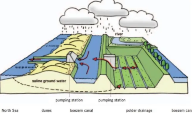
In the face of tidal flooding and climate change, strategic options can be defined under the headings attack, defend or retreat. The Dutch have led the way with attacking the sea in reclaiming land through polderisation. After creating a sea wall and a reservoir or canal behind it, water is drained to reveal a land surface below sea level. Excess water is pumped from the reservoir to the sea (see Figure 8).
Figure 8. Diagram showing dyke, polder, canal, and pumping stations in rainy conditions. Rijnland Water
Control Board.
A more common tactic with established settlements of significant population is to defend the existing coastline, ‘to hold the line’. This can be achieved with a single barrier or a combination of stepped barriers within which waterfront amenities can be incorporated (a promenade with kiosks below, for example). Land can be sculpted to form a continuous raised level under which accommodation can be created (Menteth, 2017).
In other cases the balance of cost and benefit is such that retreat is the realistic option.
2.4INCLUSIVE DEVELOPMENT
International agencies and government bodies aspire for their development policies to be inclusive of all stakeholders in society. Poverty reduction can benefit society as a whole. In attempting to meet these aims the persistence of the informal economy and informal settlements in many regions of the world should be acknowledged.
Across the developing world people are crowded together in ad-hoc accommodation without formal land titles in favelas, shanty towns or in South East Asia in kampungs.
The settlements are typically ‘illegal’ and present a challenge to the authorities. The inhabitants however, are part of the city and through the work which they do they support the city (Davis, 2017, McGuirk, 2014).
The informal settlements operate as a holding place for migration from the countryside and also a community for those who by choice or otherwise continue to live there. It will be seen that in the tropics the critical condition for marginal settlements is proximity to water bodies (rivers, canals and reservoirs) with the consequent exposure to severe flooding risk.
Since these informal settlements answer a need which is not being met by either the local government or the private market, more thoughtful ways of supporting these communities are required where needs such as safety, transport, hygiene and waste management can be addressed without breaking apart the positive aspects of a supportive community where an informal economy is also an important aspect of this (Simone, 2014).
2.5 NATURE AND THE CITY
City culture and nature have traditionally been considered as opposites; one trying to dominate the other. The limits of man’s control are now more apparent as extreme weather and flood events become more frequent and a new type of urbanism is required in response to this. Cleaner air, cyclical water systems (where they are not in place) and flexibility in accommodating the extremes of storm water require a rethinking of the prioritisation given until now to individual consumption and linear systems (Hagan, 2015).
Planted green spaces associated with both natural and man- made drainage systems allow for a sponge effect to operate during extreme weather events. Water is attenuated in soil from where it can be absorbed by plants or filter downwards towards aquifers. This reduces the temporary peaks of water flow in storm conditions. Such spaces can work closely with the topography and contours to facilitate natural drainage (McHarg, 1967) in swales and the water can be channelled towards rivers and main drainage systems (Kongjian Yu, 2013). Roof gardens, pocket parks and waterside green spaces can all be part of a soft infrastructure (or blue/ green urbanism). Nature is thus providing eco-system services, the value of which extends beyond this basic water
management function into air quality, shading and amenity (Raworth, 2017).
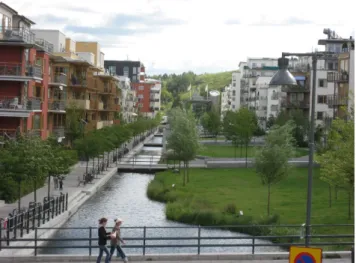
Planning of a new build residential led mixed use area can be led by ecological concerns. A bold example is Hammerby Sjostad in Stockholm a large waterside development is
‘semi urban’ not suburban, linking land adjoining waterways with extensive decks, and landscaped walkways (Urban Green-Blue Grids) (Figure 9).
Figure 9. Hammarby Sjostad, Stockholm. Soft edges to the waterside of a former industrial area.
A harder but equally flood resilient urban quarter is being built at HafenCity, Hamburg. In the Sandtorhafen floating pontoons provide a leisure focussed walkway whereas raised quay levels (two heights) provide a safe haven during extreme weather events and in a potential future of significant sea level rise (Figure 10).
Figure 10. Sandtorhafen, HafenCity, Hamburg. Vehicle and pedestrian routes (2 levels) above flood risk height.
Floating pontoons creating leisure route along the former dock.
Acknowledging the limits of barriers and pumps the Dutch began an initiative called Room for the River which sets aside flood storage areas close to major rivers. These maybe in the form of lakes, parks or garages which can store
emergency flood water. The example below shows the creation of a ‘seasonal island’ at the River Waal in Lent with the flood relief area inboard of this (Figure 11).
Figure 11. Room for the River, Lent, Netherlands.
Figure 12. Extent of urbanised area known as
‘Jabodetabek’ in 2008.
In the book Water Urbanism East (De Meulder, 2013) a variety of writers discuss the more porous water systems of indigenous tropical architecture where subsistence economies have adapted to the intensity of tropical rainfall with inventive approaches including raised dwellings, sponge like parks and water transport systems.
The discussion above provides some tools and understanding with which to address the complexity of Jakarta’s flooding problem which the article intends to demonstrate is intertwined with problems of congestion, pollution, inequality and poor facilities for commuting except for journeys by car. The article adopts the problem of flooding as fundamental to the issues facing the city.
3.0JAKARTA, INFRASTRUCTURE AND ENVIRONMENT
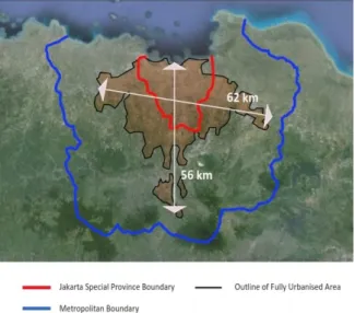
The wider metropolitan area of Greater Jakarta has grown to become a megacity of approximately 30 million people.
This is the second largest conurbation in the world after Tokyo-Yokohama. The city’s density, whilst high by European and American standards is less than that of Singapore or Hong Kong (Demographia, 2017).
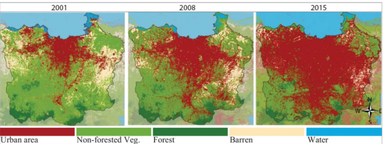
The growth of the city continues as shown in Figures 12 and 13; in Figure 12 the boundary indicated in black is that of Greater Jakarta, informally known as Jabodetabek, a name which incorporates the names of those small cities which have been absorbed into the larger conurbation.
The growth is not only in the East – West direction but extends into the upland watersheds of Bogor and beyond, replacing green and forested areas which moderated the flow of stormwater in the past.
3.1THE DEVELOPMENT OF THE CITY
From its beginnings as the Dutch colonial fort Batavia in 1619 the city has been served by systems of canals and open drains (De Meulder, 2013). With independence in 1945 came the desire to demonstrate the country’s modernity;
new boulevards, monuments, toll roads, prestigious offices and hotels and satellite cities would confirm that major progress was being made. Modernisation meant prioritising the motorcar as the principal form of transport. Those who would not be able to afford cars were somewhat excluded from this modernising project.
A Dutch team (despite the declaration of independence) created the plans for a new satellite city of Kebayoran Baru in 1948 to accommodate civil servants and other white collar workers; although the infrastructure was well considered and the plans well adopted the original proposals for green space adjoining the rivers to accommodate flood water and for piped water from a centralised water treatment plant were not implemented (Silver, p 85- 88).
The Master Plan (1965 – 1985) identified 5 pressing issues:
‘...flooding, improved sanitation, traffic congestion, inadequate housing and community facilities, control and use of land’ (Silver, p111)
In the sense that the plan made proposals or that the City would assume the authority to implement them it is clear that the same issues persist through the decades, the policies never catching up with the increased growth both of the city and of these problems. The plan did however indicate proposed development areas and the routes of highways which would serve them.
In 1973 the original team of Dutch Consultants, now funded by the UN, recommended that planning should consider the wider metropolitan region beyond the city boundary and any previously associated ‘greenbelt’; this would include established centres including Bekasi, Depok and Tangerang.
A policy of ‘bundled deconcentration’ was proposed where growth would be encouraged around these centres This mirrored the Ranstad model from the Netherlands and
would be known locally as Jabodetabek (Silver, p116- 120).
The current somewhat polycentric city could be understood to reflect this thinking.
Within the masterplan public transport would again be stressed as vital to the effective functioning of the city complex; in actuality the new growth centres would be
encouraged by linking them with new multi-lane highway construction and little new public transport would be provided. Green areas that were to have been left between these growth centres, and in fingers following the lines of the rivers helping replenish aquifers, have by now been fully urbanised.
Figure 13. The expanding city and the shrinking of green spaces 2001, 2008, 2015, showing Metropolitan boundary. The DKI boundary is overrun in 2001.
The government would turn to the Dutch again to advise on storm water management. The containment of flood water within channels, reservoirs and river banks was planned and flood relief channels, overflow reservoirs (waduk) and pumping stations completed the hard infrastructure of flood water management.
The infrastructure of the ever expanding city is thus made of hard surfaces. Little space is set aside for nature, parks, gardens or the attenuation of flood water. In extreme conditions of storms and tides (which are now becoming more frequent and more severe) the capacity of the drainage systems is exceeded. After catastrophic floods in 2007 and 2013 (Rekittke, 2013; JBA Risk Management) initiatives have been taken to dredge and maintain rivers and canals, significantly reducing the risk of and extent of flooding.
There is a low level of provision of centralised clean water and centralised treatment of foul water. Typically, site owners, large and small, extract ground water with individual pumps. This is not regulated and the capacity of aquifers is limited. Additionally, because of the mechanistic approach to storm-water management much of the rain is channelled towards the sea without the opportunity being available to replenish the aquifers. Foul water again is managed site by site and the remaining water is ‘wasted’, since it is not incorporated into a municipal treatment system. As the aquifers become drier the city is sinking (NY Times, 2017); this is happening faster than the predicted sea level rise due to climate change.
New roadbuilding was influenced by the corporate development sector and led to unrestrained private sector
development as the city expanded. These groups became powerful through their connections with the President (Suharto) and his family many of whom were also active in development. The role of the City Governor and any representation of the electorate was somewhat limited. As long as the economy was growing (and it was) and enough people believed their situation was improving wealth the focus of economic development was not a regular topic of discussion (Rukmana, 2015).
Without direction from public bodies the developers prioritised development for the wealthy and the middle class. There was little incentive to provide for those in need and the state itself didn’t commission works for those in need at any scale.
Leaf shows how the public sector (supported by loans from international organisations) was subsidising the development of the road culture and (indirectly) the fossil fuel industry (Leaf, 1994). The President’s family members had financial interests in both (toll) road systems and cars;
interests held in railway systems were not financially productive during these years. Development favoured those who could buy a house and afford a car. Many people would be left behind in this rush for modernity (Hutabarat Lo, 2010).
Day describes the city as comprising of ‘arteries and enclaves’. In prominent areas the enclaves may be business districts, shopping malls or (high rise) residential or a combination of these elements. Where the enclaves were residential these would typically be developments of homogeneous districts of similar properties housing a
similar income band and forming gated communities (Day, 2017).
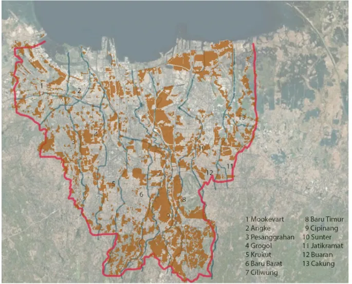
Behind the main arteries of the city are also kampung areas, which while occupying a land area of approximately 20- 30% of the city house more than 50% or more of the city’s population (Alzamil 2018). A kampung is a village like settlement in the city, which is informal and unregulated.
The word is sometimes translated into English as
‘compound’ and can have the meaning of a camp. The kampung is a persistent feature of Jakarta life through which people may transition from the countryside to a more permanent way of life. Alternatively, families may live in the same kampung for generations.
Mostly single and two storey but highly densely occupied, the informal agglomeration of ad hoc shelters constitute one of the main sources of accommodation for the poorer groups in the city. Streets are narrow and the provision of services is rudimentary. Simone (2014) describes the life and
sociability of the kampung and the tension between the formal and informal sides of the city; Kusno (2020) considers that the kampung is both an integral part of the city and a problematic environmental entity.
Kampung dwellers and squatter settlements are vulnerable to eviction and displacement as powerful government bodies or private developers assume ownership of the land which has not been typically held in freehold ownership (hak milik) (Leitner and Sheppard, 2018). Over time the land available for kampung settlement becomes less in area and more precarious particularly to the risk of flooding.
The kampungs typically border onto railways and waterways and in the case of waterways houses are particularly vulnerable to flooding. In the case of waterways these settlements occupy land which could otherwise be set aside for the blue / green corridors which the planning consultants have consistently recommended to be threaded through the city (Silver 2011) (see Figure 14).
Figure 14. Jakarta DKI map with extent of Kampungs overlaid (in brown).
New approaches involving agency, consultation and finance are required to upgrade the safety, utilities, hygiene and waste management practices of the kampung areas as part
of a wider system of addressing the wider environmental problems of the city. Some of these approaches are described in Section 5.
The Central Business District approximates to the area known as the Golden Triangle which sits between the main thoroughfares Jalan Sudirnam, Jalan Rasuna Said and the toll road Gatot Subroto. In this district are housed the principal business headquarters, financial companies and diplomatic headquarters as well as apartment towers and hotels. Building heights of 40 storeys are typical with some landmark towers higher than this.
Outside of this central zone the city has been mostly low rise, being traditionally single story with more recent developments being 2 – 3 storeys with shopping centres varying in the number of levels up to 7 – 8 storeys. With each new wave of development the frequency of tall building development increases.
The city thus went through an intense period of somewhat chaotic development (Goldblum 2000; Rustiadi 2015).
During this period the three legged stool of sustainable development (social, economic and environmental) did not have legs of equal length (Douglass 2010). The pattern persists today albeit with greater leadership and intervention from the Jakarta authorities and the central government.
4.0NEW DEVELOPMENTS SINCE 2012
With the election of Joko Widodo (currently President of Indonesia since 2014) as City Governor in 2012 a more proactive phase of city government began.
In the aftermath of chaotic floods in 2007, and again in 2013, and the ever worsening congestion, Joko Widodo acknowledged that the source of these problems and the potential solutions to them lay in the governance (or lack of governance) of the city
Two major flood defence initiatives have been taken since these floods one of these addressing river flooding and one addressing tidal flood risk from the sea linked to the sinking of the low level ground in North Jakarta.
Ambitious initiatives in public transport provision were set in motion and in 2019 an announcement made to relocate the facilities of the Capital away from Jakarta to a new city on Borneo island.
4.1 DREDGING AND CREATING ACCESS FOR CLEANING THE RIVERS AND CANALS
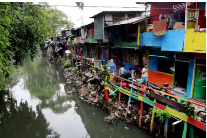
The rivers and canals had become not only polluted and blocked by debris they were inaccessible due to the kampung dwellers building right up to the water’s edge and even built into the water on precarious stilts (see Figure 15).
The authorities insisted on creating inspection roads and flood walls on the sides of the rivers and to do this they evicted those residents whose structures lay in the way; in some cases offering an opportunity to live in a low rent tower block not too far away. The rivers Ciliwung, Sunter and Pesanggrahan were to be ‘normalised’ at a width of 30 – 35m and defined by sheet piling and inspection roads. The
authorities were then able to clear accumulated debris (timber, trees and vegetation as well as plastic waste and sewage) and dredge the rivers until they were flowing much more freely than before (see Figure 15).
Figure 15. Typical Riverbank and Kampung at Cipinang before ‘normalisation’.
This policy, arrived at with difficulty because of the resistance of the kampung dwellers, can be seen as an expedient but brutal policy. To ‘naturalise’ the river a wider clearance zone would be required and more kampung dwellers would need to be relocated.
To be effective the policy has to be applied consistently along each affected river and canal. Since the ‘normalising’
of the river entailed concreting the banks water will flow more quickly until it finds another blockage or opportunity to breach its banks (Figure 16). Consistent sanitary provision within kampung areas awaits proper attention.
Figure 16. Ciliwung River after ‘normalisation’. Bukit Duri.
4.2GIANT SEA WALL PROJECT
The original ‘Great Garuda’ project announced in 2014 has faced widespread criticism and has been scaled back in scope. Public information on the project has been restricted whilst aspects of the project clearly are in progress despite funding issues.
The project has been developed by Dutch Consultants (supported now by consultants from Korea, Japan and Indonesia) in consultation with the Indonesian government at the highest level. The core aim is to provide a 45 km barrage across Jakarta Bay together with an inner sea wall , creating two lagoons whose water level can mediate between the low (and sinking) and the rising sea levels.
Extreme tidal flooding, including the nodal 18.6 yearly tides (when sun and moon are in alignment) can be resisted.
Fluvial and pluvial flooding within the city will not be addressed by this project:-
‘’This Master Plan deals specifically with floods from the sea. Urban floods due to heavy rain in the city or river floods are outside the scope of this Master Plan.’’ (CMEA 2014(a) National Capital Integrated Coastal Development, p20).
A harbour toll road and reclaimed land for development, including artificial islands and land in the shape of the Indonesian garuda (eagle), provide support and additional rationale for the ambitious project (see Figure 17).
Figure 17. Scope of ‘Great Garuda’ project. Outer and Inner Sea Walls, lagoons, land reclamation.
Figure 18. Image of reduced scale project, 2019.
The barrage (and the project) is stated to be necessary to
protect North Jakarta (4 million inhabitants) from tidal flooding in the face of seasonal high tides, storms and predicted sea level rise. However, it disrupts the ecology of
the whole bay area and the lives of the local fishing community. As more information has become available and through independent studies, more critical scrutiny became possible and the project entered the political arena (Colven 2017, CMEA 2014, Yarina 2018). A reduced scale version of the project is shown in Figure 18.
The new lagoons will receive the water from the 13 rivers of the delta. The aspiration is for this water to be a source of
clean water for the city. Currently this water is not clean as the provision of water treatment and piped water across the city is far from comprehensive. Ground water extraction is widespread and leading to the sinking of the city; the rate of this exceeds the projected sea level rise and is the most significant contribution to the flood risk (New York Times 2017) (see Figure 19). Neither of these matters are addressed by the Sea Wall project; indeed the project makes them more urgent (Garschagen 2018).
Figure 19. Land subsidence since 1997 baseline (BBC 2018). See original for animated graphic including future projections.
The sinking of the land in North Jakarta could be addressed over time as part of a managed retreat, giving away some of the land to wetland and leisure areas. This may be more beneficial than insisting on preserving the entirety of the land for the city.
The provision of water and the treatment of water is complicated by legal disputes over the privatisation of these services to international corporations (insisted upon by the World Bank in 1998) and the failure of these corporations to meet agreed levels of service in terms of expanding provision to districts which did not have them.
In 2019 10% of the inner barrier had been completed and works to the outer wall were ongoing (see Figure 20) . Some land at Muara Baru was below the level (already, the city’s sinking continues) of the wall’s foundations and sea water was leaking into the newly ‘protected’ area.
The barrage is predicted to protect Jakarta from tides for 50 years; although the target completion date is 2025 much work remains to be done (Jakarta Post video, Sept 2019).
Figure 20. Inner barrier construction progress at Muara Baru.
4.3MASS RAPID TRANSIT (MRT) AND LIGHT RAIL TRANSIT (LRT)
A modal switch from private cars to public transport helps relieve congestion (and the pressure to build more roads) and pollution. As this change becomes part of the new
direction of the city a proportion of the concrete infrastructure of motor vehicles can be set aside for pedestrians, greenery and porous paving.
From being a city without a mass transit system, plans are in the making for a substantial city wide system. Phase 1 of the North – South MRT line (Figure 21, in blue) was opened in March 2019, part of the first such line in the megacity.
The line begins above ground in the southern suburb of Lebak Bulus going underground at Senayan and ending at Hotel Indonesia roundabout. Phase two of this line (in green below) is under construction and will continue to Kota in the historic and colonial core of the city near the sea.
A further East- West MRT line (dotted below) is in the development stage and is scheduled to begin construction soon.
Figure 21. Jakarta MRT lines Status 2020.
MRT’s President Director, William Sabandar has bold ambitions for the development of public transport in the city:
‘’Today, only 20 percent of the total travel in Jakarta is on public transport. Our vision is to see that share increase to 80 percent.’’ (Argawal, 2019)
Other initiatives in the public transport sphere include:- 1) A Light Rail Transit (LRT) line has begun operation in North East and is planned to run into the city centre. A separate company, Greater Jakarta LRT, plans to complete routes from Bekasi and Cibubur to Cawang and then onwards to the city centre at Kuningan and Jalan Sudirman at Dukuh Atas (LRT) and :-
2) The TransJakarta bus network, which served 800,000 passengers per day in 2019, and is intended to be integrated with the Mass Rapid Transit (MRT) system.
The current character of the area around the various stations and their potential for Transit Oriented Development is analysed in Budiati et al (2018). Criteria for analysis used include density, walkability, mixture of uses and prescriptions for change vary as the line approaches the heart of the city. A similar initiative has been underway in Los Angeles, creating affordable accommodation at new transit stations (Metro).
Whilst the pedestrian infrastructure across the city is rudimentary at this stage, the full extent of this planned integrated transport network and the Transit Oriented Developments is potentially transformative in the life of the city (Vice 2018, LRT City 2021).
Denser development facilitated by transport frees up space for pedestrians, cyclists, green/ blue landscape and porous paving, park and garden areas; a softer infrastructure. All of this will act as a sponge to soak up stormwater in extreme weather conditions and release it slowly after the storm has passed, a process of attenuation of floodwater.
The new transit oriented developments can and should facilitate decentralized working arrangements, which have been valuable during the Covid 19 pandemic. Local co- working spaces with strong digital connections and shared facilities support working from near home and reduce the need for commuting to the centre of the city.
Still far away is the notion that space could be found for cycling in Jakarta; investment in green / blue corridors away from the highways and toll roads could be provide some safe alternative routes with cleaner air.
4.4THE LOSS OF CAPITAL STATUS
President Sukarno (1945-67) considered the relocation of the capital during his presidency and others have queried the viability of the city in the face of its multiple logistical and environmental problems (Wong, 2013). In August 2019 the government announced that the capital would be relocated out of Jakarta to a site near Balikpapan in East Kalimantan, on the island of Borneo. Joko Widodo is quoted:-
‘The burden Jakarta is holding right now is too heavy as the centre of governance, business, finance and trade.’ (The Telegraph).
Not only will much of the apparatus of government (and an anticipated 1.5 million jobs in the civil service) be removed from Jakarta, but also the pressure for corporations to locate in the soon to be former capital will be reduced.
The reduction of congestion will be complimented by the redundancy of government buildings and sites which can be reassigned for more inclusive and greener development and / or provide sites for the soft infrastructure of parks and wetlands with multiple benefits for health and water management. In response to the change the city can seek to
attract investment through its quality of environment for the first time. This can be an opportunity for the city to begin to reinvent itself.
5.0WHAT MORE CAN BE DONE?
Although much has been done in clearing waterways and providing new transport systems the city continues to sink and the vulnerability to flooding remains high. The following actions taken together and with some urgency can help provide a viable future for the city:
• Provide piped water supply and foul drainage water treatment city wide to urgently phase out ground water extraction
• Accelerate the transition to active travel
• Support existing satellite centres with digital hubs to encourage working away from the centre of the city as part of a networked 15 minute walkable city
• Plant trees and provide porous ground surfaces and green roofs wherever possible
• In consultation with kampung communities develop strategies for consolidation (where appropriate), enhancing water supply, garbage collection, sewage treatment and safety plans for flood risk events
• At key areas across the city a safe pedestrian realm should be provided above highest anticipated flood levels linking key building complexes
• Mapping the topography of North Jakarta to begin creating a long term plan for managed retreat and consolidation incorporating areas of water based mangrove parks for stormwater management
• Develop strategies for restoring rivers, including pollution control, space for floodwater and green/ blue waterside amenity corridors
In order to improve or alter the conditions in the kampung communities, trust needs to be built based on transparent discussions and achievable goals. This has not been sought since Ali Sadikin’s Kampung Improvement Programme of the late 1970’s (Silver 2011a).
Recent engagements between kampung communities and the authorities have focused on the most precarious edges of these communities where residents have been stigmatized for their ‘illegality’ and their responsibility for flooding. Should providing enhanced infrastructure to an individual kampung area not be feasible a dialogue with kampung dwellers is required to ascertain satisfactory new living arrangements (Rukmana 2016). Such a dialogue took place in the development of the Kampung Susun (elevated village) proposal developed by Ciliwung Merdeka (Free / Independent Ciliwung) and Studio Akanoma (Yu Sing) Architects. The informality of the kampung is raised on multiple levels, echoing the streets in the sky of the original modernist architects. The ground level is clear of habitable space and not a life safety risk in a flood event. As a compact project of 6 levels it facilitates the densification of the kampung and the potential release of land adjoining the river (Figures 22 and 23). The project attracted much
publicity but was dependent on external funding which did not materialise. Notwithstanding the forced informality of the project’s layout, a successful and economic building typology could emerge from the refinement of this concept (Forum Kampung Kota 2016).
Figure 22. Kampung Susun. Street in the sky. Informal activity between enclosed accommodation.
Figure 23. Kampung Susun. Low cost informal settlement developed as a multi storey community, releasing space for
a soft water’s edge.
A conciliatory approach was taken by the residents of the Kampung Tongkol who, in order to escape eviction, retreated behind the 10m river service access zone required by the authorities and consolidated their river edge with their own funds (Figure 24) (Renzi 2018, Architecture Sans Frontieres Indonesia 2016, 2017).
Following his election on a platform of no evictions for kampung residents in 2017, Jakarta Governor Anies Baswedan has supported the construction of 5 storey affordable accommodation at Kampung Akuarium, North Jakarta, in consultation with residents who were evicted by the previous Governor. 107 units have been built to date and the remaining 3 blocks (out of 5 ) are planned to continue.
The project is robust and repeatable at scale but lacks the elevated shared spaces and soft landscaping of the Ciliwung Merdeka project (Jakarta Post 2021).
Figure 24. Kampung Tongkol, North Jakarta. Local initiative to consolidate river bank buildings and fit with
the city’s goals for river normalisation.
New development models will be required which position principal activity and all habitable accommodation above flood risk levels, whilst leaving lower risk commercial activity and softer areas below. In addition floating developments on newly formed waterbodies can be planned as safe from flood risk. In recent decades elevated pedestrian zones have been developed to separate the pedestrian from traffic; an extensive example of an elevated pedestrian zone is the Central Elevated Walkway in the Admiralty area of Hong Kong (see Figure 25) (Ponting, Lim). More traditional tropical precedents is include stilted villages in rivers such as the Kampung Ayer (water village) in Bandar Seri Begawan, Brunei.
Figure 25. Central Elevated Walkway Hong Kong. An extensive raised pedestrian network of linkways.
In schools of architecture, urbanism and landscape architecture new proposals can be explored and tested as ideas without the usual constraints of financial and political approval. Provocatively Bindi Purnama’s thesis is called
‘Let it flood’ . The work explores North Jakarta as a network of connected islands and acknowledges the ridges and valleys of South Jakarta as a design constraint rather than a problem to be ironed flat (Purnama 2019).
The practicalities of creating sponge-like wetland amenity areas this can first be explored by mapping the topography of the extensive risk areas in North Jakarta and prioritising the lowest; this can help identify where sponge like wetland areas could be set aside as redevelopment occurs. Cut and fill operations can then create high ground while digging deeper to provide storage volume for floodwater. The work of Kongjian Yu’s company Turenscape, mostly across China, has found political and financial support for this new way of flexing with nature rather than fighting it, delivering many wetland amenity areas in major cities (Turenscape, Figure 26).
The balance between land and water in this area may need in future to be radically different to that found today.
Figure 26. Yanweizhou Park, Jinhua, China. Turenscape.
Partially flooded condition.
The banks of the rivers and waterbodies are a potential site for soft infrastructure as anticipated floodwater can be absorbed within landscaped areas which, when this is not an issue, can be an amenity for walking, exercise and cycling making new connections away from the congested traffic.
As development sites become available following the relocation of government institutions compact redevelopment models could help release land for shared green spaces by water.
The worldwide Covid-19 pandemic has highlighted the importance of healthy living environments in all areas of society. Safe and affordable housing and green areas for local commuting and exercise are typical of these needs, which will benefit everyone.
6.0SUMMARY AND FINDINGS
The article has analysed the hard infrastructure of Jakarta in the 20th century and proposed new softer infrastructures for the 21st century. This is summarised in Table 1.
Table 1. Hard and Soft Infrastructure A reinvention of the infrastructure and urbanism of a city
such as Jakarta will require both the top down strategic planning of forward thinking and responsible authorities such as those in Hamburg and Copenhagen as well as the engagement of authorities with more local bottom up initiatives as shown in the integration of South American favelas into the systems of the city (McGuirk, 2014).
The notion of a climate emergency is becoming more widely understood even if action does not yet match the scale of the various crises. In Jakarta the threat of being regularly submerged in polluted water still attracts partial solutions without a coherent and connected set of proposals.
The orchestration of water is central to the continuation of tropical megacities. Tropical rainwater should be captured at ground level for retention and distribution as water supplies and excess water absorbed for more gradual release as storms subside. Foul water is a resource to be recycled as drinking water following appropriate treatment.
A new infrastructure and urbanism will bring back people and nature to a central role within the city which has often been lost to motor transport and technical systems.
FIGURES
Figure 1 Author, using MapChart Figure 2 Author, using MapChart
Figure 3 Author, based on figure in Wijayanti, P (2016);
Estimation of river flood damage in Jakarta, Indonesia.
Natural Hazards 86: 1059-1079 Figure 4 ©Reuters/ Supri/ files 2007
Figure 5 Jakarta Globe Facebook page, 17 January 2013 Figure 6 Gabriel Koo.
Available at:-
https://gabrielfileosetiawan.wordpress.com/2013/02/
(accessed 21 July 2021)
Figure 7 Author’s phone screenshots from Petabencana on 2 January 2020. Map system available at
http://petabencana.id/map/jakarta
Figure 8 Rijnland Water Control Board (2009). Flood Control in the Netherlands, p. 9. https://moam.info/queue/flood- control-in-the-netherlands-hoogheemraadschap-van-
rijnland_5a04be871723dd21b32f7fbe.html (accessed 31 August 2021)
Figure 9 Design for Health. Flickr. Creative Commons Figure 10 HafenCity, Hamburg. ©eyewave/123RF.COM
Figure 11 Baca Architects
Figure 12 Background: Google Earth, Author’s graphics overlaid from Jakarta Street Atlas (2008) Singapore: Periplus Figure 13 Robbany I, Gharghi A, Traub K-P. Land Use Change Detection and Urban Sprawl Monitoring in Metropolitan Jakarta (Jabodetabek) from 2001 to 2015.
Available at https://knepublishing.com/index.php/KnE- Engineering/article/view/5862 (accessed 31 August 2021).
Dates added by Author.
Figure 14 Author’s overlay with Figure 3. Map of kampung distribution by Prakoso, Saputra and Dewangga from Kusno A (see references).
Figure 15 Jakarta Post / Seto Wardhana https://www.thejakartapost.com/news/2018/04/30/jakartans- turn-art-self-discipline-escape-eviction.html (accessed 31 August 2021)
Figure 16 Ramdani / Media Indonesia Figure 17 Garschagen M (see references) Figure 18 Jakarta Post (2019). Available at:
https://www.thejakartapost.com/news/2019/07/21/new-face- of-jakartas-giant-sea-wall-includes-toll-road-2000-ha- reclamation-plan.html (accessed 31 August 2021)
Figure 19 BBC News at bbc.co.uk/news and Heri Andreas (2018). Jakarta, the fastest-sinking city in the world - BBC News (accessed 31 August 2021)
Figure 20 Screenshot from Jakarta Post, report on Muara Baru,
https://www.youtube.com/watch?v=mwUNyAPKBCM&ab _channel=TheJakartaPost (accessed 31 August 2021)
Figure 21 Jakarta MRT Route Map,
http://jakartabytrain.com/the-maps/jakarta-mrt-route-map/
(accessed 31 August 2021).
Figures 22 and 23 Yu Sing / Akanoma Studio Figure 24 Alessandra Renzi
https://theconversation.com/jakarta-social-and-housing- justice-should-not-be-a-gamble-on-global-markets-table- 78849 (accessed 31 August 2021)
Figure 25 City Life. Walking Hong Kong above ground.
http://hkcitylife.com/index.php?route=product/product&pat h=105_269_271&product_id=2121 (accessed 31 August 2021)
Figure 26 Turenscape
https://www.turenscape.com/en/project/detail/4629.html (accessed 31 August 2021)
REFERENCES (BOOKS AND JOURNALS)
Alzamil W (2018) Evaluating Urban Status of Informal Settlements in Indonesia: A Comparative Analysis of Three Case Studies in North Jakarta. Journal of Sustainable Development 11(4):148.
DOI: 10.5539/jsd.v11n4p148
Boschken H (2012) Global Cities are Coastal Cities Too:
Paradox in Sustainability Urban Studies 50:1, 1760-1778.
DOI: 10.1177/0042098012462612
Budiati W et al (2018) Determining the potential for Transit Oriented Development along the MRT Jakarta corridor. IOP Conference Series: Earth and Environment Science 158 012020.
Budiyono Y, Aerts J, Brinkman J et al. (2015) Flood risk assessment for delta mega-cities: a case study of Jakarta.
Natural Hazards 75: 389.
DOI: 10.1007/s11069-014-1327-9
Colven, E (2017) Understanding the Allure of Big Infrastructure: Jakarta’s Great Garuda Sea Wall Project.
Water Alternatives10 (2):250-264. Available at www.water- alternatives.org (accessed on 31 August 2021).
Coordinating Ministry for Economic Affairs (CMEA) (2014).
National Capital Integrated Coastal Development Master Plan. CMWA: Jakarta, Indonesia.
Coordinating Ministry for Economic Affairs (CMEA) (2014(a)). As above, p 20.
Davoudi S (2012) Resilience: A Bridging Concept or a Dead End? Planning Theory and Practice 13:2 pp 299-307.
DOI: 10.1080/14649357.2012.677124
Davis M (2017) Planet of the Slums. London: Verso.
Dawson A (2017) Extreme Cities, The Peril and Promise of Urban Life in the Age of Climate Change. London: Verso pp 153 - 187
De Meulder B (2013) Batavia, Simon Stevin in the Tropics: A Catastrophic Displacement of A Universal Water Urbanism Prototype. In De Meulder B and Shannon K (eds) Water Urbanisms East. Zurich, Switzerland: Park Books, pp188- 195.
Day, J (2017) Spires and Gyres, Places Journal, November 2017.
DOI: 10.22269/171128
Demographia World Urban Areas 13th Annual Edition: 2017:
04. Available at db-worldua.pdf (demographia.com) (accessed 31 August 2021).
Douglass M (2010) Globalization, Mega-projects and the Environment: Urban Form and Water in Jakarta. Environment and Urbanization Asia 1: 45-65.
DOI: 10.1177/097542530900100105
Dunphy R, Myerson D, Pawlukiewicz, M. (2003) Ten Principles for Successful Development around Transit.
Washington, D.C. ULI-The Urban Land Institute.
Gehl, J (2010) Cities for People. Washington, USA: Island Garschagen M, Surtiari GAK, Harb M, (2018) Is Jakarta’s New Flood Risk Reduction Strategy Transformational? in Transforming Development and Disaster Risk, Sustainability 2018, 10(8), 2934.
DOI: 10.3390/su10082934
Goldblum C and Wong T-C (2000); Growth, crisis and spatial change: a study of haphazard urbanisation in Jakarta, Indonesia. Land Use Policy 17, 29-37.
DOI: 10.1016/S0264-8377(99)00043-5
Hagan S (2015) Ecological Urbanism: the nature of the city.
Abingdon, UK: Routledge.
Hutabarat Lo R (2009) The City as a Mirror: Transport, Land Use and Social Change in Jakarta. Urban Studies 47: 529-55.
DOI: 10.1177/0042098009348557
Jacobs J (1993, originally 1961) The Death and Life of American Cities. New York: Random House
Kongjian Yu (2013) China’s Water Crisis: Projects Leading Policy: Water Urbanism across Scales in De Meulder B and Shannon K (eds) Water Urbanisms East. Zurich, Switzerland:
Park Books, p20-47.
Kusno, A (2020) Middling Urbanism and the Contradictory Space of the Kampung in Indonesian Capitalism in Platform.
Available at :- PLATFORM: Middling Urbanism and the Contradictory Space of the Kampung in Indonesian Capitalism (platformspace.net) (accessed 31 August 2021) Leaf, M. (1996). Building the Road for the BMW: Culture, Vision, and the Extended Metropolitan Region of Jakarta.
Environment and Planning A: Economy and Space, 28(9), 1617–1635.
DOI: 10.1068/a281617
Leitner H, Sheppard E (2018) From Kampungs to Condos?
Contested accumulations through displacement in Jakarta.
Environment and Planning A Vol 50(2)437-456.
DOI: 10.1177/0308518X17709279
McGuirk J (2014) Radical Cities, Across Latin America in Search of a New Architecture Verso. London: Verso.
McHarg I (1969) Design with Nature. New York. The Natural History Press
Menteth, W (2017) Designing Sustainable Sea Defences:
Developing Principles for Procedures, Processes and Practices AMPS Proceedings - 9 Living and Sustainability p342 -359. London South Bank University. Available at: - https://www.researchgate.net/project/Architectural-design- research-in-Portsmouth-and-the-Solent-region-as-a-
regional-and-global-paradigm (accessed on 31 August 2021).
Mostafavi M, Doherty G (eds) (2016) Ecological Urbanism.
Harvard University Graduate School of Design. Zurich, Switzerland: Lars Muller Publishers.
Padawangi R, Douglass M. (2015) Water, Water Everywhere:
Toward Participatory Solutions to Chronic Urban Flooding in Jakarta. Pacific Affairs Volume 88, No 3.
DOI: 10.5509/2015883517
Palevsky B. (2019) Motorcycle Taxis in Jakarta, Indonesia;
The case for recognition and integration of motorcycle taxis in Jabodetabek’s transportation system. Penn Institute of Urban Research. Available at
https://penniur.upenn.edu/uploads/media/11_Palevsky.pdf (accessed 31 August 2021).
Purnama, B. (2019) Let it Flood: Ciliwung Delta. Available at https://issuu.com/bindiraditya/docs/letitflood_min157 (accessed 31 August 2021).
Raworth, K. (2017); Doughnut Economics; Seven ways to think like a 21st Century Economist. London, Penguin Random House.
Rekittke J (2013) Being in Deep Water: Finding the Horizontal Timeline, Jakarta, Indonesia. In De Meulder B and Shannon K (eds) Water Urbanisms East. Zurich, Switzerland: Park Books, p 88
Rukmana D (2015); The Change and Transformation of Indonesian Spatial Planning after Suharto’s New Order Regime: The Case of the Jakarta Metropolitan Area.
International Planning Studies 20:4: pp 350-370.
DOI: 10.1080/13563475.2015.1008723
Rukmana D (2016) Flood Governance in Jakarta: The Role of CBO’s in Mitigating Annual Floods. Available at:
http://www.mei.edu/content/map/flood-governance-jakarta- role-community-based-organizations-mitigating-annual- floods (accessed 31 August 2021).
Rustiadi E, Pribadi DO, Pravitasari AE, Indraprahasta GS and Iman LS (2015) Jabodetabek Megacity: From City Development Toward Urban Complex Management System.
In Singh RB (ed) Urban Development Challenges, Risks and Resilience in Asian Mega Cities. Japan: Springer: pp421-445.
DOI: 10.1007/978-4-431-55043-3_22
Silver C (2011) Planning the Megacity: Jakarta in the twentieth century. Abingdon, UK: Routledge
Silver C (2011a). as above p 136 – 1402
Simone A (2014) Jakarta, Drawing the City Near.
Minneapolis, USA: University of Minnesota Press.
Tyler S, Moench M (2012) A framework for urban resilience.
Climate and Development Vol 4, no 4 p311-326.
DOI: 10.1080/17565529.2012.745389
United Nations Environment Programme (UNEP).
Sustainable Development Goals. Available at https://www.unep.org/explore-topics/sustainable-
development-goals/why-do-sustainable-development-goals- matter/goal-9 (accessed 31 August 2021).
Wong T-C, Sevin O (2013) Should we abandon Jakarta?
Cahiers d'Outre-Mer [Online], 261. Faut-il abandonner Jakarta?
DOI: 10.4000/com.6760
Yarina, L (2018). Your Sea Wall Won’t Save You. Places Journal.
DOI: 10.22269/180327
REFERENCES (ONLINE AND NEWS OUTLETS)
Architecture Sans Frontieres Indonesia (2016). Co-housing Project at Ciliwung Waterfront. Architecture in
Development. Available at:
https://architectureindevelopment.org/project/570 (accessed 31 August 2021).
Architecture Sans Frontieres Indonesia (2017). Pilot House and Kampung Upgrading in Jakarta. Available at
https://issuu.com/asfindonesia/docs/complete_asfid- asfaw_2017 (accessed 31 August 2021)
Argawal, R; Sabandar, W (2019). Building self-sustaining public transport: An interview with William Sabandar, president director of MRT Jakarta. Available at: - https://www.mckinsey.com/industries/capital-projects-and- infrastructure/our-insights/building-self-sustaining-public- transport-an-interview-with-william-sabandar-president- director-of-mrt-jakarta (accessed 31 August 2021)
Busquets, J. Restoring Seoul's Cheonggyecheon River / The 10th Veronica Rudge Green Prize in Urban Design; Harvard Graduate School of Design, 2013
https://www.youtube.com/watch?v=BdU3zkFckKM (accessed 31 August 2021)
CNN (2020). 66 people killed now by flooding in Jakarta, and more rain appears to be on the way. Available at: - https://edition.cnn.com/2020/01/06/asia/jakarta-floods-intl- hnk/index.html (accessed 31 August 2021).
Economist (2020), Flooding in Jakarta is the worst for over a decade. Available at: -
https://www.economist.com/asia/2020/01/11/flooding-in- jakarta-is-the-worst-for-over-a-decade (accessed 31 August 2021).
Forum Kampung Kota (2016). Kampung Susun Manusiawi Kampung Pulo. Available at: -
https://medium.com/forumkampungkota/kampung-susun- manusiawi-kampung-pulo-4eb363c74b31 (accessed 31 August 2021).
Jakarta Post (2021) Residents to settle in new Kampung Susun Akuarium next week. Available at :-
https://www.thejakartapost.com/news/2021/08/20/residents- to-settle-in-new-kampung-susun-akuarium-next-week.html.
(accessed 31 August 2021).
JBA Risk Management A Retrospective View of Floods in Jakarta. Available at
https://www.jbarisk.com/flood-services/event-response/a- retrospective-view-of-floods-in-jakarta/ (accessed on 31 August 2021).
LRT City. Available at: - https://lrtcity.com/en (accessed 31 August 2021)
Mayor of London (2012) Green Infrastructure and Open Environments The All London Green Grid Supplementary Planning Guidance. Available at
https://www.london.gov.uk/what-we-
do/environment/environment-publications/all-london-green- grid (accessed 31 August 2021).
Metro, Transit Oriented Communities. Available at https://www.metro.net/projects/transit-oriented- communities/ (accessed 31 August 2021).
New York Times (2017) Kimmelman M. Jakarta Is Sinking So Fast, It Could End Up Under Water Available at https://www.nytimes.com/interactive/2017/12/21/world/asia/
jakarta-sinking-climate.html (accessed 31 August 2021).
PetaBencana, Real time open source flood map. Available at https://petabencana.id/map/jakarta (accessed 31 August 2021).
Ponting A, Lim, V. Elevated Pedestrian Linkways, Boon or Bane? Centre for Liveable Cities, Singapore. Available at https://www.clc.gov.sg/docs/default-
source/commentaries/elevated-pedestrian.pdf (accessed 31 August 2021).
Renzi, A (2018). Jakarta: social and housing justice should not be a gamble on global market’s table. The Conversation.
Available at https://theconversation.com/jakarta-social-and- housing-justice-should-not-be-a-gamble-on-global-markets- table-78849 (accessed 31 August 2021).
Resilient Cities Network (2021). Available at
https://resilientcitiesnetwork.org/urban-resilience/ (accessed 31 August 2021).
The Telegraph (2019). Indonesia will move capital to the island of Borneo. Available at
https://www.telegraph.co.uk/news/2019/08/26/indonesia- will-move-capital-island-borneo/ (accessed 31 August 2021).
Time (2020) 66 People have died in Indonesia’s devastating floods. Here’s what to know. Available at
https://time.com/5761097/jakarta-indonesia-floods/
(accessed 31 August 2021).
Turenscape (2019) Available at
https://www.turenscape.com/en/home/index.html (accessed 31 August 2021).
Urban Green-Blue Grids, Hammarby Sjostad. Available at https://www.urbangreenbluegrids.com/projects/hammarby- sjostad-stockholm-sweden/ (accessed on 31 August 2021).
World Resources Institute (2020). New Data Shows Millions of People, Trillions in Property at Risk from Flooding — But Infrastructure Investments Now Can Significantly Lower Flood Risk. Available at https://www.wri.org/news/release- new-data-shows-millions-people-trillions-property-risk- flooding-infrastructure (accessed 31 August 2021).
Vice (2018) Jakarta is about to become an entirely new city.
Available at
https://www.vice.com/en_asia/article/ne55wg/jakarta-is- about-to-become-an-entirely-new-city (accessed 31 August 2021).
© 2021 by the author. This article is an open-access article distributed under the terms and conditions of the Creative Commons Attribution (CC BY) license (http://creativecommons.org/licenses/by/4.0/).