Opusc. Zool. Budapest, 2021, 52(Supplementum 1): 03–196
_______________________________________________________________________________________________________
On the Diplectroninae and Hydropsychinae (Trichoptera) of India, with related taxa. A tribute to Fernand Schmid
J. OLÁH1, G. VINÇON2 & K.A. JOHANSON3
1János Oláh,Tarján u. 28, H-4032 Debrecen, Hungary. E-mail: profolah@gmail.com
2Gilles Vinçon, 55 Bd Joseph Vallier, F-38100 Grenoble, France. E-mail: gvincon@gmail.com
3Kjell Arne Johanson, Swedish Museum of Natural History, Department of Zoology, Box 50007, SE-10405 Stockholm, Sweden. E-mail: kjell.arne.johanson@nrm.se
Abstract. The overall declining state of the western taxonomy is clearly documented by the present fate of the extremely high valued and huge unidentified caddisfly material collected in India and deposited in the Canadian National Collection.
Due to the general lack of both financial and scientific resources in taxonomy, this huge collection remained almost untouched during the last 70 years after its collection. With a tribute to the collector, Fernand Schmid, the great caddisfly collector and taxonomist we have reconstructed his collecting activities of the five years in India by geolocalization and elaborated about ten percent of his undetermined Hydropsychidae in the Diplectroninae and Hydropsychinae subfamilies.
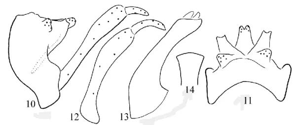
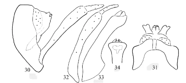
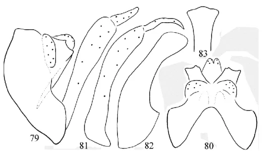
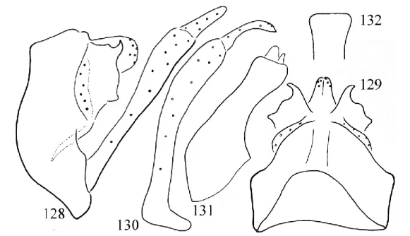
Description of 145 new species from this small fragment of the huge unidentified collection demonstrates a pronounced underestimation of the biodiversity in general, routinely measured by gross phenomics. During this study we have reinstated the species status of seven taxa: Diplectrona kirimaduhela Schmid, 1958, stat. restit., Cheumatopsyche rienga Oláh &
Johanson, 2008, stat. restit., Cheumatopsyche amurensis Martynov, 1934, stat. restit., Cheumatopsyche banksi Mosely, 1942, stat. restit., Cheumatopsyche processuata (Martynov, 1927), stat. restit., Potamyia klakahana (Ulmer, 1951), stat. restit., Potamyia proboscida Li & Tian, 1996, stat. restit., and raised the subspecies status to species rank of Diplectrona stigmatica Banks, 1937, stat. nov. Furthermore, we have etablished four new species groups, sixteen new species complexes and described 145 new species as follows: Diplectrona aurovittata new species group: D. hasada new species complex: D.
bandara sp. nov., D. borghata sp. nov., D. chiangma sp. nov., D. chingsa sp. nov., D. daotama sp. nov., D. grimona sp. nov., D. jaraina sp. nov., D. khopurna sp. nov., D. khumyara sp. nov., D. kualagomba sp. nov., D. kurlingha sp. nov., D. lyngkota sp. nov., D. mawkhapa sp. nov., D. mirgona sp. nov., D. muktapura sp. nov., D. mynsoa sp. nov., D. nongina sp. nov., D.
nongra sp. nov., D. nongronga sp. nov., D. sirkasha sp. nov., D. sironga sp. nov., D. sumatrana sp. nov., D. tairenpokpa sp.
nov., D. tungpa sp. nov., D. tamdaophila new species complex: D. aisahka sp. nov., D. beluma sp. nov., D. dhampa sp. nov., D. dhankuta sp. nov., D. huishua sp. nov., D. khasiaca sp. nov., D. khasigupta sp. nov., D. madonga sp. nov., D. meghalaya sp. nov., D. mopaenga sp. nov., D. parala sp. nov., D. rumkhenga sp. nov., D. sitahoana sp. nov., D. sohra sp. nov., D.
coalescens species group: D. hongkonga sp. nov., D. kattalaimala sp. nov., D. shimoga sp. nov., D. gombak new species group: D. albofasciata new species complex, D. fasciata new species complex: D. buitenzorga sp. nov., D. panaona sp. nov., D. simalura sp. nov., D. tonkulana sp. nov., D. wailima sp. nov., D. gentinga new species complex: D. gentinga sp. nov., D.
gombak new species complex: D. barisana sp. nov., D. merangira sp. nov., D. phanoma sp. nov., D. temengora sp. nov., D.
tengaha sp. nov., D. taprobanes new species group: D. abmaka sp. nov., D. kambaita sp. nov., D. kamikarka sp. nov., D.
koda sp. nov., D. komadia sp. nov., D. madhya sp. nov., D. satanwada sp. nov., D. sirtranga sp. nov., D. tienmua sp. nov., D.
umlanga sp. nov., Cheumatopsyche lepida species group: C. assamha sp. nov., C. fordula sp. nov., C. madpradha sp. nov., C.
manimapa sp. nov., C. pondora sp. nov., C. puramukta sp. nov., C. purmapa sp. nov., C. sohkha sp. nov., C. swampa sp.
nov., C. dubitans species group: C. mawpya sp. nov., C. excisa species group: C. chuga sp. nov., C. costalis species group: C.
dangchura sp. nov., C. kamposka sp. nov., C. lagaironga sp. nov., C. mawjana sp. nov., C. mawprana sp. nov., C. nonga sp.
nov., C. nongajra sp. nov., C.oinamla sp. nov., C. salaka sp. nov., C. yunnana sp. nov., C. concava species group: C.
haflonga sp. nov., C. kambirona sp. nov., C. khasia sp. nov., C. korosa sp. nov., C. myntanga sp. nov., C. nongrima sp. nov., C. chinensis species group: C. bandarkhala sp. nov., C. delhia sp. nov., C. hanoia sp. nov., C. hotaya sp. nov., C. pega sp.
nov., C. quangchua sp. nov., C. tamda sp. nov., C. tongoma sp. nov., C. holzschuhi species group: C. apuma new species complex: C. apuma sp. nov., C. nyukma sp. nov., Potamyia czekanovskii species group: P. flavata new species complex: P.
binhoa sp. nov., P. chitwana sp. nov., P. congsa sp. nov., P. moccha sp. nov., P. nikalandugola species complex: P. hasalaka sp. nov., P. tamilnada sp. nov., P. chinensis species group, P. flava species group: P. dinamla sp. nov., P. trenhona species group: P. barata sp. nov., P. jinhongensis new species complex: P. dhauliana sp. nov., P. yunnanica new species complex:
P. namha sp. nov., P. namkhana sp. nov., P. topali sp. nov., P. umbaso sp. nov., P. vietnama sp. nov., Hydromanicus hermosus species group: H. flavoguttatus species complex: H. bukit sp.nov., H. mawpyut sp. nov., H. mawshun sp. nov., H.
Oláh, Vinçon & Johanson: On the Diplectroninae and Hydropsychinae (Trichoptera) of India
luctuosus species group nom. nov.: H. asor new species complex: H. shilliang sp. nov., H. eleasar new species complex: H.
kambaitiensis sp. nov., H. kamengensis sp. nov., H. kashong sp. nov., H. sikkimensis sp. nov., H. tibetensis sp. nov., H.
inferior new species complex: H. darban sp. nov., H. hasad sp. nov., H. jakhand sp. nov., H. khalband sp. nov., H. mattiyang sp. nov., H. mynso sp. nov., H. nondeng sp. nov., H. luctuosus species complex: H. fureses sp. nov., H. garhwal sp. nov., H.
khopum sp. nov., H. laitlyn sp. nov., H. manilon sp. nov., H. mapum sp. nov., H. pufok sp. nov., H. thangrain sp. nov., H.
tharauyang sp. nov., H. tiyang sp. nov., H. tungnath sp. nov., H. umbonatus new species complex: H. kover sp. nov., H.
manisir sp. nov., H. ronghongkung sp. nov., H. sirohis sp. nov., H. spatulatus species group: H. rahung sp. nov., H.
spatulatus species cluster.
Keywords. Geolocalization, Fernand Schmid, India, Diplectroninae, Hydropsychinae, new species.
INTRODUCTION
e have carried out this study on a very small fragment of hydropsychid specimens from Schmid’s collection of Indian Trichoptera with description of 145 new species with our fine phenomics in order to demonstrate its huge di- versity and extremely high scientific value. First and foremost we wish to thank for this hydro- psychine material we have elaborated in this pa- per and to express our acknowledgement to Fernand Schmid (1924, Sion, Switzerland – 1998, Ottawa, Canada), the Great Trichoptero- logist, the Ultimate Collector of caddisflies and the teacher of the first author. Soon after com- pleting his groundbreaking research, synthesis and revision, on Limnephilidae family (Weaver &
Nimmo 1999), he made several long-lasting and wide-ranging collecting expeditions to Pakistan (1953–1954), Ceylon (1954: Sri Lanka), Iran (1955–1956), and to India (1958–1962). His ex- peditions were often lengthy. He spent at least nine months of the year in the field for four years straight in India, except for 1960, when he was there for seven months (Lonsdale 2000).
TRIBUTE TO FERNAND SCHMID This entire decade of the intensive field work between 1953 and 1962 was organised through the University of Lausanne, Switzerland, and re- sulted in an enormous catch of research material.
The vast amount of the unidentified materials is deposited in the Canadian National Collection of Insects in Ottawa and still waiting for taxonomists to be elaborated. This will be a hard job, espe- cially to handle the pinned fragile microcad- disflies of a few milimeters. There are two cabi-
nets full of pinned, unidentified Trichoptera and much more unspecified specimens are scattered throuhout the collection that was sorted to genus by Fernand Schmid himself (Lansdale 2018).
Who will elaborate this extremely rich material with its ultimate scientific value?
The realy high value of Schmid’s unidentified Trichoptera collection is documented by the re- sults of the present study. There have been elab- orated only about ten percent of the unidentified specimens of the Diplectroninae and Hydropsy- chinae subfamilies, out of the about 40 families or subfamilies and described over 100 new species.
It does not mean however, that we have to mul- tiply 100 by 200 in order to estimate the real potential of the ca. 20 thousands of Trichoptera species in and around the Indian subcontinent.
Actually Schmid has estimated the total number of the South West Asian Trichoptera species about 40 thousands (Schmid 1984). According to Malicky (1993) this high number may be an overestimate even for South East Asia.
It is a shame and an axiomatic failure of our western culture that this high-valued material, collected by ultimate talent, devotion and enthu- siasm of a great man, is still almost untouched after 70 years of its collection. However, this is not a surprise! This is the symptomatic result of the depressing scenario created by the declining state of the Western taxonomy. The decline of taxonomy, the basic science of sciences, has start- ed by degrading the phenotype with the conflation of systematics and beanbag genetics that is by the
“modern synthesis”. This sinister product of sci- entism is assimilated and adopted in the new systematics of Huxley (1940) and Mayr (1942).
W
Oláh, Vinçon & Johanson: On the Diplectroninae and Hydropsychinae (Trichoptera) of India
With this ideology and science policy all the re- sources are drained from taxonomy and chan- nelled into the “modern synthesis”. This decline is supported by the virtual, “modern” analytic phi- losophy and logical positivism; by the underes- timation of empiricism against rationalism and by degrading experience of phenomenology against logics of virtual analysis. All these are resulted in the lack of taxonomists to effectively describe biodiversity; in the lack of adaequate sampling density and frequency; and especially in lack of population sampling, the key momentum in the contemporary perspectives of species level taxo- nomy. Our teacher in taxonomy, Fernand Schmid is turning in his grave!
Unlike to trips in Sri Lanka, Pakistan and Iran, Schmid has not published any general survey or mapping of his trips to India. We have started to study this small fragments of his hydropsychine specimens relying on the locality names printed on the pinned labels. However, names are short- living things which may change rapidly for politics and transliteration (Malicky 2018). There- fore we have decided to search the coordinates for Schmid’s collecting sites by reconstructing on maps his daily movement during his five years long collecting activities in India. Our maps and tables with figured sites help our present study to identify the distribution character states of species described in this paper. Furthermore, it provides basic geo-localisation for the specimens and may help in giving some impetus for future studies on the huge undetermined caddisfly material col- lected by Fernand Schmid in India.
Geo-localisation of the Schmid collecting sites in India
The geo-localization of Schmid’s collecting localities was based on the great work of Lonsdale (2020) concerning the Schmid Trichoptera col- lection in India, and, at a lesser degree on the fau- nistic list given by Aubert (1966), regarding the Stoneflies collected by Schmid in the same Indian regions. Schmid’s Indian activities and localities were hand written in several notebooks but with- out detailed localization except the name of a
village or hamlet followed by its elevation. All these notebooks are already retranscribed by Malicky (2018). Moreover, one manuscript of Schmid is also directly available on the WEB
«Field Notes and Taxonomic Observations of Trichoptera in India from 1958 to 1962»
(https://archive.org/details/fieldnotestaxon1schm).
It is a scan of the original notebook of the Ku- maon region (NW India, Uttarakhand), completed by ecological notes: type of water course, name of the river, aquatic or surrounding vegetation, cur- rent speed, type of substratum. These two works are the basis of our reseach work to geolocate the Schmid collecting localities, a hard task since Schmid didn’t give any route map for his indian collecting trips and since many indian locality names have changed, as explained by Malicky (2018) and Lonsdale (2020).
For the geo-localization, we have mainly used two motor reseaches (Google Map and Open Street Map) and in some cases the indications given by Lonsdale (2020) who has already located some of them. For a few high elevation sites of difficult access, the locality names are not known on the main motor reseaches, but some of them can be found elsewhere on the WEB. For instance, it is the case of Theulocha and Mugu- thang, in the heights of the Sikkim mountains (4500 m asl.) that we found on a trecker’s map on an advertisement site (http://www.worldmarco polo.com/site_map.html)
Most localities of Schmid have been located though their names are often slightly different from the one given by Schmid (phonetic script).
In case of two different names, we give first the name written in the Schmid’s notebook and then the current name found on our maps. To plot the Schmid’s localities on a map has helped us to find some names with their new orthography when it corresponds to a localitity placed between two others on the Schmid route. However, some localities remain unknown but for interested re- searchers, an approximative position can be deduced between the two closest known localities, by interpolation. Lacking numbers on the maps correspond to these unknown localities but more
Oláh, Vinçon & Johanson: On the Diplectroninae and Hydropsychinae (Trichoptera) of India
often to some localities that are already ploted on the map, when Schmid has returned several times at the same place or at different elevations in the same place, as it is the case for many localities (for instance on the Manipur map, Sirohi Ka- shong: 14, 15, 16, 17, 29, 41, 42). On some maps, we use different colours to separate the different trips of Schmid in the same area, to make the map more readable.
For a better visualisation of the whole col- lecting effort made by Schmid in India, a first global map (Map 1) shows the 8 main indian
regions carefully visited by Schmid: Uttarakhand Map 2), Sikkim and North Western Bengal (Map 3), Assam (Map 4), Meghalaya (Map 5), Manipur + Mizoram (Map 6), Kerala (Map 7a), Tamil Nadu (Map 7b). This global map also shows how Schmid has carefully prepared his successive col- lecting trips in India, in the great purpose to give to Science a most complete tribute to the Indian Trichoptera as well as to other insects orders also collected by him for his colleagues (Plecoptera, Diptera, …). It is probably the most considerable effort ever made to prospect a land nearly as big and complex as Europa.
Map 1. The 8 main indian regions visited by Schmid.
Oláh, Vinçon & Johanson: On the Diplectroninae and Hydropsychinae (Trichoptera) of India
North West India (Uttarakhand) = Kumaon 1958 (Map 2)
This high moutainous region of north western India, named under its old appellation «Kumaon»
by Schmid, nowdays named Uttarakhand, is placed westward the Nepal and southward the Tibet (Map 1). The ecological notes given for many localities were written at the end of the Kumaon’s notebook of Schmid.
1 Dera Dun = Dehra Dun, 30°18'04.8"N 78°07' 02.4"E
2 U.P. Rishikesh, 1200 ft, Gange River and lateral brooks and springs, 30°05'16.7"N 78°17' 22.8"E, 25–31.03.1958
3 Nasendranagar = Narendranagar, 2200 ft, small river and lateral tributaries in narrow valley, 30°09'36.9"N 78°17'24.4"E, 4.04.1958
4 Agra = Agrakhal (Lonsdale 2020), 3000–5000 ft, small brook with mosses tributary of Huini River, 30° 12′50″N 78°19′41″E, 5–6.04.1958 5 Birnu, 4000 ft, small brook with mosses,
7.04.1958
6 Katkor = Katkot, 3500 ft, small brook, 30°14' 08.5"N 78°20'53.9"E, 7.04.1958
7 Ampata, 2500–3500 ft, small river tributary of Huini River, 30°16′6″N 78°22′ 18″E, 10.04.
1958
8 Rampur, Northwards Bhandargaon, 3000–5000 ft, small torrent tributary of Huini River, 30°
17'23.6"N 78°22'03.6"E, 11–12.04.1958 9 Tipli = Teepali, 3000 ft, hygropetric habitat
below a cascade, 30°17'26.7"N 78°21'27.5"E, 13.04.1958
10 Nagani = Nagani Sera, 4000 ft, small river tributary of Huini River, 30°18'41.9"N 78°
20'29.9"E, 13.04.1958
11 Dobalgaon = Dobhalu Ka = Than (the locality indicated in Lonsdale (2020) is wrongly as- signed to the Schmid itinerary since it is much too far from the road taken by Schmid), 5000–
6000 ft, 2 small torrents, 30°19'49.7"N 78°23' 32.5"E, 14.04.1958
12 Jaspur, 3500–4500 ft, small torrent in bushes, 30°23'34.7"N 78°25'21.4"E, 15.04.1958 13 Teri = Tehri Garhwal District, 2500–5000 ft,
small torrent tributary of Bhillangana River
and hygropetric habitat, 30°22'13.7"N 78°25' 55.4"E, 16–21.04.1958
14 Pau Kal = Paukhal Gaon, 4000–5000 ft., river tributary of Bhillangana River and hygropetric habitat, 30°21'48.9"N 78°36'36.7"E, 21–23.04.
1958
15 Jakhanr = Jahkand, 3500 ft, below the village, small river tributary of Alaknanda River, 30°
19'49.4"N 78°39'20.9"E, 24.04.1958
16 Dangchura = Dang Chaunra, 3000–3200 ft, 2 small brooks tributary of Takali Gad, 30°
15'55.8"N 78°43'02.2"E, 25.04.1958
17 Rudraprayag, 1900–2300 ft, small river tribu- tary of Alaknanda and hygropetric habitat, 30°
17'08.7"N 78°58'58.3"E, 28.04.1958
18 Rampur (the locality indicated in Lonsdale (2020) is wrongly assigned to the Schmid itinerary since it is much too far from the road taken by Schmid, while our locality named Rampur is just placed between the previous and next localities on the Schmid’s route), 2100–3000 ft, small river and hygropetric habitat, 30°22'01.7"N 78°59'12.7"E, 29.04.
1958
19 Barakot, 2450–3000 ft, medium size river and hygropetric habitat, 30°23'58.9"N 79°01' 32.2"
E, 30.04.1958
20 Chandrapuri, 2500–3500 ft, small river in forest and hygropetric habitat, 30°25'36.0"N 79°04'02.9"E, 1.05.1958
21 Gupta Kashi = Guptkashi, 3200–4000 ft, 2 small brooks very steep, 30°31'31.3"N 79°05' 20.0"E, 2.05.1958
22 Khumyara = Khumera (Lonsdale 2020), 4300–
5000 ft, 2 small brooks in bushes and hygropetric habitat, 30°33′ 15″N 79°03′44″E, 3–4.05.1958
23 Barasu, 5000–6000 ft, small torrent, Manda- kini tributary, in dense forest, 30°36′5″N 79°
1′45″E, 5.05.1958
24 Tarsali, 6000–7000 ft, torrent in dense forest, 30°35′40″N 79°2′1″E, 6.05.1958
25 Akhrotkoti, 5700 ft, wonderful forest river, Mandakini tributary, 8.05.1958
26 Gaurikund, 6400–7200 ft, small torrent, Mandakini tributary, in bushes, 30°39'11.2"N 79°01'37.0"E, 9–11.05.1958
Oláh, Vinçon & Johanson: On the Diplectroninae and Hydropsychinae (Trichoptera) of India
Map 2. Schmid’s road in Uttarakhand.
27 Jungal Chatti = Jungle Chatti, 8000–8500 ft, torrent and hygropetric habitat below a high cascade, 30°40'49.6"N 79°02'39.2"E, 11.05.
1958
28 Ukhal, 9500 ft, torrent, brooks and springs, 16.05.1958
29 Kedarnath, 11800–13000 ft, torrent below a snowfield and brooks, 30°44′4″N 79°4′ 1″E, 13–16.05.1958
30 Idem 28, Ukhal, 9500 ft, 16.05.1958
31 Idem 25, Akhrotkoti, 5700 ft, 17–18.05.1958 32 Trijugi = Trijuginarayan, 7000 ft, small brook
with mosses, in rhododendron forest, 30°38' 48.8"N 78°59'18.2"E, 19.05.1958
33 Manghu Chatti, 9000–9270 ft, nice brooks in bushes and fields, 20–21.05.1958
34 Yawana = Gawana Malla, 6000 ft, small river tributary of Bhichangana, 30°32'18.9"N 78°
48'35.9"E, 22–24.05.1958
35 Ghuttu, 5000 ft, 30°31'43.0"N 78°47'22.6"E, 23.05.1958
36 Panwalli = Panwali Kantha (Bugyal) Bhinl- gana range, 11000 ft, small brook in forest, 30°34'07.9"N 78°51'58.8"E, (22), 25.05.1958 37 idem 32, Trijugi = Trijuginarayan, 7000 ft,
26.05.1958
38 idem 22, Khumyara, 4300–5000 ft, 27–28.
05.1958
39 Ugsara, 4500 ft, small steep brook, 29.05.1958 40 Dogalbeta = Dogalbhita = Duggal Bittha,
7000–8300 ft, 2 steep brooks with mosses in forest, 30°29'10.1"N 79°11'23.3"E, 30.05.1958
Oláh, Vinçon & Johanson: On the Diplectroninae and Hydropsychinae (Trichoptera) of India
41 Tungnath, 9000 ft, brook with mosses in forest, 30°28'41.9"N 79°12'43.9"E, 1.06.1958 42 Mandoli = Mandal, 7500 ft, 30°27'38.2"N 79°
16'33.2"E, 1.06.1958
43 Duldhar, 4500 ft, big torrent and small brook, 2.06.1958
44 Chamoli, 3800 ft, along the Gange River, 30°
24'16.1"N 79°19'46.6"E, 3.06.1958
45 Pipalkoti, 4400 ft, small steep brook, 30°25' 58.0"N 79°25'58.9"E, 6.06.1958
46 Hilang, = Hailang = Helong, 5000–7500 ft, along the Gange River, 30°31'25.0"N 79°30' 16.6"E, 6–7.06.1958
47 Phaia = Chaien, 5780 ft, along Alaknanda River, 30°34'03.3"N 79°32'54.8"E, 11.06.1958 48 Gangrea = Ghangria = Ghangaria, 7500–10000 ft, big torrent and small brook, 30°41'54.5"N 79°35'19.3"E, 12–15.06.1958
49 Lokpal, 14000 ft, glacial lake, 30°41'59.3"N 79°36'56.0"E, 13.06.1958
50 Binaik Chatti, 7000–7500 ft, steep torrent, 16.06.1958
51 Hanuman Chatti, 9000 ft, brooklets in grassland, 30°41′41″N 79°30′51″E, 17.06.1958 52 Badrinath, 10100–11000 ft, torrent, brooks and springs, 30°44'45.6"N 79°29'33.7"E, 18–
19.06.1958
53 Mana, 10300 ft, brooks and springs, with mosses, 30°46'21.0"N 79°29'39.7"E, 20.06.
1958
54 Moussa Pani, brooks and springs, with mosses, 11800 ft, 30°47'31.7"N 79°29'29.6"E, 21.06.
1958
55 Nag Tal, 13100 ft, springs and lake, 30°51'22.8"N 79°28'07.1"E, 22.06.1958 56 Phurunda, 15000 ft, Saraswati River, brooks
and springs in grassland, 30°56'35.7"N 79°25' 57.5"E, 24.06.1958
57 Saraswati, 16000 ft, Saraswati River, 30°59' 14.3"N 79°23'22.0"E, 25–26.06.1958
58 Jagrao, 17300 ft, Saraswati River, 31°02'03.6"
N 79°23'02.5"E, 26.06.1958
59 Chamrao, 14200 ft, brooks and springs with mosses, 30°54'15.5"N 79°27'35.3"E, 27.06.1958
60 Idem 52, Badrinath 10100–11000 ft, torrent, brooks and springs, 30°44'45.6"N 79°29'33.7"
E, 28–29.06.1958
61 idem 51, Hanuman Chatti, 9000 ft, brooklets in grassland, 30°41′41″N 79°30′51″E, 30.06.1958 62 idem 50, Binaik Chatti, 7000–7500 ft, steep
torrent, 2.07.1958
63 Jashimath = Joshimath = Jyotirmath, 7100 ft, at the light of the Rest House, 30°32'55.0"N 79°33'43.2"E, 3–4.07.1958
64 Tapoban = Tapoban Joshimat = Tapovan, 7300 ft, river and steep brooks under bushes, 30°
29'05.3"N 79°37'28.3"E, 5.07.1958
65 Lata, 7500 ft, along the Dauli Ganga River and brooklet, 30°29'56.0"N 79°42'49.2"E, 6.07.
1958
66 Phagti = Fagti, 7874 ft, along the Dauli Ganga River, 30°33'34.8"N 79°45'58.7"E, 7.07.1958 67 Kosa, 9219 ft, along the Dauli Ganga River
and brooklet, 30°40'31.5"N 79°51'39.0"E, 8.
07.1958
68 Malari, 10000–11000 ft, nice torrent, brooks and springs with mosses, 30°41'00.4"N 79°
53'23.2"E, 9–10.07.1958
69 Gamsali, = Gamshali, 11000 ft, big glacial torrent, 30°45'18.0"N 79°49'24.9"E, 11.07.
1958
70 Timarsan, 11122 ft, along the Dhauli Ganga River, lateral torrent and brooks, 30°45'52.5"N 79°50'54.7"E, 12–14.07.1958
71 Siunti, 12260 ft, along the Dhauli Ganga River and Dhamian Nadi torrent, 30°48'36.3"N 79°
48'04.4"E, 15.07.1958
72 Ganesh Ganga, 14400 ft, steep brooklet, 30°
55'58.0"N 79°50'44.1"E, 16.07.1958
73 Khar Yongma, 16000 ft, 30°57'22.9"N 79°
46'56.5"E, 17.07.1958
74 Khar Todma, 17000–18000 ft, 30°57'26.0"N 79°44'45.1"E, 18–19.07.1958
75 Geldhung, 14600 ft, big glacial torrent, 30°
56'01.9"N 79°50'08.8"E, 20.07.1958
76 Gothing, 12400 ft, brooklet in grassland, 30°
49'01.9"N 79°48'28.4"E, 21.07.1958
77 Bampa, 10500 ft, along the Dhauli Ganga River, 30°44'21.1"N 79°49'48.4"E, 23.07.1958 78 Suraithota, 7200 ft, along the Dhauli Ganga
River and lateral brooklet, 30°31'52.2"N 79°44'38.5"E, 25.07.1958
79 Rini, 7000 ft, big torrent and brooklet in bushes, 30°28'19.2"N 79°42'21.5"E, 27.07.
1958
Oláh, Vinçon & Johanson: On the Diplectroninae and Hydropsychinae (Trichoptera) of India
80 idem 64, Tapoban, 7300 ft, brooks in forest, 28.07.1958–2.08.1958
81 Kulara = Khullara Camp Site, 12000 ft, small torrent in grassland with trees, 30°27'35.2"N 79°35'08.0"E, 3–4.08.1958
82 Dakwani = Dhakwani (on the path to the Kuari Pass), 9300–10950 ft, steep torrent in forest, 30°26'26.5"N 79°33'41.8"E, 5–9.08.1958 83 Pana, 8200 ft, 3 brooks in bushes, 30°23'27.2"
N 79°33'20.5"E, 10.08.1958
84 Pagna Malla = Pagana, 5955 ft, steep brook in grassland, 30°22'15.7"N 79°32'34.7"E, 11.08.
1958
85 Ghona Tal = Gohna Lake, 5580 ft, torrent in forest flowing in the lake, 30°22'24.3"N 79°
31'31.4"E, 12.07.1958
86 Begar Nala, 6560 ft, 2 torrents in forest, 30°20'33.7"N 79°30'09.7"E, 13.08.1958 87 Tarak Tal = Taraktal, 7540 ft, 30°20'35.5"N
79°29'04.2"E, 14.08.1958
88 Ramni = Ramani, 8200 ft, torrent, 30°18' 55.4"N 79°30'21.2"E, 15.08.1958
89 Gery = Gairi = Gari, 6290 ft, river, torrent and brook in bushes, 30°16'21.7"N 79°33'44.3"E, 16.08.1958
90 Dhar, 7220 ft, Nandakini tributary, river in forest and lateral canals, 17.08.1958
91 Sutol, 7250 ft, meeting of 2 rivers in forest, 30°16'13.1"N 79°37'24.5"E, 18.08.1958 92 Kanol, 8530 ft, springs and brooklets with
mosses, 30°15'05.8"N 79°35'51.4"E, 19.08.
1958
93 Wan, 7880 ft, torrents in bushes, 30°12'13.6"N 79°37'06.6"E, 20.08.1958
94 Lohajang = Lohjang = Loha Jung, 6070 ft, along the Gyan Ganga River, 30°07'10.1"N 79°36'30.1"E, 21.08.1958
95 Salkhola = Ichchholi Laga Silkhola, 4240 ft, junction of Pindar and Kail Ganga Rivers, and lateral brooklets, 30.057177, 79.584542, 22.
08.1958
96 Koti = Kothi, 4200–5500 ft, steep brooklets in forest, 30°01'52.2"N 79°34'04.9"E, 23.08.1958 97 Gwaldam, 6000–6400 ft, small torrent in bushes and brook in forest with mosses, 24–
29.08.1958
98 Koti, idem 96, 4200 ft, 30.08.1958
99 Palwara, 4300 ft, torrent, Pindar tributary, in forest, 30°02'39.9"N 79°36'48.0"E, 1.09.1958 100 Lingari = Lingadi, 4400 ft, brooks and
springs, 30°01'22.8"N 79°39'59.3"E, 1.09.
1958
101 Maupata, 4500 ft, along the Pindar River, 2.09.1958
102 Harmal, 5100 ft,torrent, Pindar tributary, 30°03'16.8"N 79°47'16.5"E, 4–5.09.1958 103 Bilap, 5500 ft, River in forest, 30°04'30.4"N
79°48'38.5"E, 6.09.1958
104 Dhur = Dhoor Village, 7400 ft, steep brooks in forest, 30°05'13.9"N 79°54'33.5"E, 8–9.09.
1958
105 Khati, 7700–8000 ft, along the Pindar River and brooks with mosses, 30°06'18.4"N 79°
56'33.7"E, 10–11.09.1958
106 Dwali, 8410 ft, torrent and brooks, 30°10' 34.0"N 79°59'31.2"E, 12–16.09.1958
107 Phurkia, 8510 ft, big torrent and brooklets in forest, 30°12'58.3"N 79°59'50.6"E, 13.09.1958 108 Rata, 11000 ft, brooklets in grassland and Rhododendron bushes, with mosses, 30°15' 05.8"N 79°59'39.1"E, 14.09.1958
109 Saran, 7200 ft, torrent and nice brooks in forest, with mosses, 30°01'07.7"N 79°52' 43.3"E, 17.09.1958
110 Dhakuri Guest House, 9000 ft, brooks in forest, with mosses, 30°04'37.5"N 79°55' 06.4"E, 18.09.1958
111 Loharkhet, 5770 ft, torrent, 30°02'11.0"N 79°56'13.9"E, 19.09.1958
112 Sarju, 5700–4000 ft, 2 rivers, steep brooks in bushes and hygropetric habitat, 29°59'16.7"N 79°54'53.1"E, 21.09.1958
113 Kapkot, 3700 ft, river tributary of Sarju, 29°56'18.3"N 79°54'06.2"E, 21.09.1958 114 Chhana, 3500 ft, nice river, lateral hygro-
petric habitat, 29°53'00.2"N 79°46'31.4"E, 22.09.1958
115 Bagheswar = Bageshwar, 3200 ft, Sarju River and small river tributary with mosses, 29°
50'33.3"N 79°46'32.0"E, 23.09.1958
116 Bamrari, 3700 ft, Gornati River and brooklets in forest, lateral hygropetric habitat, 29°
52'40.7"N 79°40'50.2"E, 24.09.1958
117 Bajnath = Baijnath, 3800 ft, Gornati River, 29°54'22.8"N 79°36'52.2"E, 25.09.1958
Oláh, Vinçon & Johanson: On the Diplectroninae and Hydropsychinae (Trichoptera) of India
118 Sirkot, 4200 ft, river and brooks in bushes, 29°58'42.3"N 79°34'16.3"E, 26.09.1958 119 Idem 97, Gwaldam, 6000 ft, 27–30.09.1958 120 Simra = Simar Pul, 5800 ft, nice rivers in
forest, 30°03'28.7"N 79°29'37.4"E, 1–2.10.
1958
121 Nail, 5000–6000 ft, swampy brooklets, 29°
58'37.6"N 79°26'26.9"E, 3.10.1958
122 Chulera Sim = Chulerasim, 3800 ft, Ram- ganga River and lateral steep torrent, 29°55' 59.4"N 79°24'33.0"E, 4.10.1958
123 Tarag Tal = Tarag lake, 3900 ft, toorents flowing in a lake, 29°53'01.0"N 79°25'25.0"E, 5.10.1958
124 Chaukhutia, 3050 ft, along Ramganga River, 29°53'12.3"N 79°21'00.6"E, 6.10.1958
125 Sat Tal, 4100 ft, several lakes, 11.10.1958 126 Naukucchiya Tal = Naukuchia Taal, 4100 ft,
lake, 12.10.1958
127 Ranibagh, 1778 ft, torrent, 29°17'14.0"N 79°
33'00.6"E, 13.10.1958
Sikkim and North Western Bengal localities, 1959 (Map 3)
This high mountainous region is surrounded westward by the Nepal, northward by the Tibet and eastward by the Bhoutan (Map 1).
North Western Bengal
1 Singtam, 2625 ft, 27°03'48.5"N 88°13'02.6"E, 11.03.1959
Map 3. Schmid’s road in Sikkim and North Western Bengal.
Oláh, Vinçon & Johanson: On the Diplectroninae and Hydropsychinae (Trichoptera) of India
2 Pul Bazar = Pulbazar, 2400 ft, 27°04'29.7"N 88°12'11.9"E, 12.03.1959
3 Dhangia Bazar, 3280 ft, 13.03.1959
4 Takvar = Tukvar, 1760 ft, 27°05'50.0"N 88°
15'28.3"E, 14.03.1959 Sikkim
5 Naya Bazar, 1060 ft, 27°08'49.6"N 88°16'46.6"
E, 15–16.03.1959
6 Tharpu, 2625 ft, 27°08'43.5"N 88°11'41.0"E, 17.03.1959
7 Dharmdin = Daramdin, 2854–3200, 27°08'03.6"
N 88°09'49.1"E, 18.03.1959 North Western Bengal
8 Bara Hala = Berea?, 4920 ft, 27°06'20.5"N 88°
09'18.7"E, 19.03.1959
9 Dilpa, 6260 ft, 27°04'44.1"N 88°05'12.8"E, 20.
03. 1959
10 Dilpa, 5500 ft, 27°04'31.9"N 88°05'19.6"E, 21.
03.1959
11 Bara Hata = Berea, 5000 ft, 27°06'20.5"N 88°
09'18.7"E, 22.03.1959
12 Rimbik, 6560 ft, 27°07'11.6"N 88°06'17.3"E, 23.03.1959
13 Shepi = Sepi Gaon, 7200 ft, 27°07'38.4"N 88°
05'52.9"E, 23.03.1959
14 Phedigaon, 7000 ft, 25.03.1959 Sikkim
15 idem 5, Naya Bazar, 1060 ft, 27°08'49.6"N 88°
16'46.6"E, 28.03.1959
16 Chakung, 4920 ft, 27°09'12.5"N 88°14'37.8"E, 29.03.1959
17 Samdong = Chota Samdong, 3600 ft, 27°10' 50.3"N 88°13'34.8"E, 30.03.1959
18 Samdong = Chota Samdong, 4100 ft, 27°10' 50.3"N 88°13'34.8"E, 31.03.1959
19 Dethang = Deythang, 4000 ft, 27°12'03.5"N 88° 13'17.6"E, 1.04.1959
20 Rapham, 5250 ft, 2.04.1959
21 Hi = Hee, 4200–5500 ft, 27°15'19.7"N 88°
10'54.4"E, 3.04.1959
22 Dentham = Dentam, 4500 ft, 27°15'37.4"N 88°
08'24.9"E, 4.04.1959
23 Uttare = Uttarey, 6950 ft, 27°15'36.3"N 88°05' 55.1"E, 5.04.1959
24 Srinagi, 4920 ft, 27°16'11.7"N 88°08'54.1"E, 6.04.1959
25 Bongteng = Bangten, 5800 ft, 27°16'31.7"N 88°09'39.6"E, 6.04.1959
26 Sardong, 2600 ft, 27°17'05.9"N 88°11'42.6"E, 6.04.1959
27 Tikjak = Tikjya, 4900 ft, 27°17'25.1"N 88°
13'43.3"E, 7.04.1959
28 Chongpung, 5000 ft, 27°19'34.8"N 88°14' 09.8"E, 8.04.1959
29 Tinglin = Thingle, 2950 ft, 27°20'31.9"N 88°
13'45.9"E, 8.04.1959
30 Kechoiperi = Khechiperi = Khecheopalri Lake, 5900 ft, 27°21'07.3"N 88°11'25.8"E, 9.04.1959 31 Chojo = Tsozo, 3980 ft, 27°21'58.5"N 88°
12'21.5"E, 10.04.1959
32 Yoksam = Yuksom, 5600 ft, 27°22'20.6"N 88°13'21.0"E, 10.04.1959
33 Zomphuk, 6500 ft, 11.04.1959
34 Bakkim = Bakhim Guest House, 6890 ft, 27°25'41.9"N 88°11'10.3"E, 12–13.04.1959 35 Dzongri, 13222 ft, 27°28'39.0"N 88°09'48.8"E,
14.04.1959
36 Tangshing = Thangsing Trekkers’s hut, 12200 ft, 27°30'59.3"N 88°11'07.5"E, 17.04.1959 37 Churong = Kukchurung Trekkers’s hut, 12460
ft, 27°30'12.1"N 88°10'31.1"E, 18.04.1959 38 Tikipchu = Tipik chu, 13800 ft, 27°28'37.0"N
88°05'11.0"E, 19.04.1959
39 Tikipchu, 15000 ft, 27°29'47.3"N 88°04'16.4"
E, 20.04.1959
40 Gopetang = Gonpatang (Népal close to the Indian border), 12200 ft, 27°25'44.9"N 88°03' 27.9"E, 21.04.1959
41 Chunjom, 6800 ft, 23.04.1959 42 Ramtang, 5780 ft, 24.04.1959 43 Palam, 5100 ft, 25.04.195,9
44 Singbeng = Singyang, 4920 ft, 27°19'09.7"N 88°12'41.6"E, 26.04.1959
45 Pemayangtse, 5600 ft, 27°18'14.7"N 88°15' 12.8"E, 27.04.1959
46 Ligship = Likship, 1700 ft, 27°16'13.5"N 88°
17'34.8"E, 28.04.1959
47 Doling, 5900 ft, 27°17'20.6"N 88°20'41.9"E, 29.04.1959
48 Mangalbarey = Manglay Bazaar, 2800 ft, 27°
16'10.7"N 88°25'27.3"E, 30.04.1959
Oláh, Vinçon & Johanson: On the Diplectroninae and Hydropsychinae (Trichoptera) of India
49 Sirwani, 1150 ft, 27°14'29.0"N 88°28'56.8"E, 1.05.1959
50 Gangtok, 5570 ft, 27°19'54.9"N 88°36'48.5"E, 3.05.1959
51 Lingdok, 4600 ft, 27°23'14.8"N 88°34'21.0"E, 7.05.1959
52 Nantpung, 3980 ft, 8.05.1959 53 Dakchu, 2300 ft, 9.05.1959
54 Mangang = Mangan, 3600 ft, 27°29'42.2"N 88°31'45.9"E, 9.05.1959
55 Masin, 4920 ft, 10.05.1959
56 Nanga = Naga falls, 5000 ft, 27°32'24.2"N 88°
37'51.1"E, 12.05.1959
57 Teng = Tung bridge on Lachung River, 4600 ft, 27°32'58.6"N 88°38'43.0"E, 12.05.1959 58 Chumtang = Chungthang, 5120 ft, 27°36'14.0"
N 88°38'44.9"E, 13.05.1959
59 Yugang = Yuigang, 5700 ft, 27°37'45.7"N 88°37'02.5"E, 14.05.1959
60 Lathong = Latong, 6560 ft, 27°39'35.4"N 88°
36'08.7"E, 15.05.1959 61 Benshoi, 7550 ft, 16.05.1959
62 Chachu = Tarum Chachu Hot Spring, 9950 ft, 27°42'30.4"N 88°36'35.4"E, 17.05.1959 63 Gey, 11650 ft, 27°44'41.9"N 88°38'34.5"E, 18.
05.1959
64 Gey, 13200 ft, 27°46'18.5"N 88°39'48.1"E, 19.
05.1959
65 Gey, 12000 ft, 20.05.1959
66 idem 62, Chachu = Tarum Chachu Hot Spring, 9900 ft, 27°42'30.4"N 88°36'35.4"E, 21.05.
1959
67 Chateng = Chaten, 8700 ft, 27°32'24.2"N 88°
37'51.1"E, 22.05.1959
68 Lachen, 8930 ft, 27°43'45.0"N 88°33'02.3"E, 23.05.1959
69 Zema, 8900 ft, 27°45'18.8"N 88°32'32.9"E, 24.05.1959
70 Yedang, 10600 ft, 27°46'47.8"N 88°30'04.1"E, 25.05.1959
71 Thomrachen, 11900 ft, 27°46'11.4"N 88°26' 12.9"E, 26.05.1959
72 Yahuk = Yabuk, 13050 ft, 27°45'53.2"N 88°
23'30.7"E, 27.05.1959
73 Yagtang= Yakthang, 11200 ft, 27°46'31.1"N 88°28'04.4"E, 28.05.1959
74 Thomphyak, 12800 ft, 27°47'00.3"N 88°26' 57.9"E, 29.05.1959
75 Theuchung, 14100 ft, 27°48'28.4"N 88°23' 30.1"E, 30.05.1959
76 Theulocha = Thieulacha, 14900 ft, 27°48' 59.9"N 88°21'52.9"E, 30.05.1959
77 Langbos = Langbo, 14750 ft, 27°51'21.9"N 88°21'25.5"E, 31.05.1959
78 Dolkhasampat = Dolma Sampa, 14700 ft, 27°
53'02.5"N 88°23'00.0"E, 1.06.1959
79 Lungma, 15320 ft, 27°52'06.7"N 88°19' 39.0"E, 2.06.1959
80 Changsang = Changsang glacier, 15750 ft, 27°52'11.2"N 88°17'44.7"E, 2.06.1959
81 Goma Sechen, 16730 ft, 27°50'46.6"N 88°17' 00.1"E, 3.06.1959
82 idem 78, Dolamsampa = Dolma Sampa, 14700 ft, 27°53'02.5"N 88°23'00.0"E, 5.06.1959 83 Kora Chamna, 16250 ft, 6.06.1959 84 Kora La Cho, 16700 ft, 6.06.1959 85 Siling, 14900 ft, 6.06.1959
86 Mugutang = Muguthang = Lhonak, 14750 ft, 27°53'56.5"N 88°25'01.4"E, 7.06.1959
87 Sase, 14170 ft, 7.06.1959 88 Rongsha, 14400 ft, 8.06.1959
89 idem 70, Yedang, 10600 ft, 27°46'47.8"N 88°30'04.1"E, 9.06.1959
90 idem 70, Yedang, 9680 ft, 27°46'47.8"N 88°
30'04.1"E, 10.06.1959
91 idem 69, Zema = Zemu chu River, 8900 ft, 27°45'19.2"N 88°32'32.4"E, 11.06.1959 92 idem 67, Chateng = Chaten, 8700 ft, 27°
32'24.2"N 88°37'51.1"E, 12.06.1959
93 idem 68, Lachen, 8900 ft, 27°43'45.0"N 88°33'02.3"E, 13.06.1959
94 idem 69, Zema, 9100 ft, 27°45'18.8"N 88°
32'32.9"E, 14.06.1959 95 Yunga, 10000 ft, 14.06.1959 96 Tombu, 10450 ft, 15.06.1959
97 Talam, 11300 ft, 27°49'28.6"N 88°33'07.2"E, 16.06.1959
98 Yagtang = Yathang, 11650 ft, 27°51'46.5"N 88°32'42.2"E, 17.06.1959
99 Kalip, 12100 ft, 18.06.1959
100 Tanggu = Thangu, 12800 ft, 27°54'36.8"N 88°42'42.2"E, 19.06.1959
101 Taling, 13800 ft, 27°55'50.7"N 88°32'08.4"E, 21.06.1959
102 Denkung, 15750 ft, 28°01'13.8"N 88°36' 06.3"E, 22.06.1959
Oláh, Vinçon & Johanson: On the Diplectroninae and Hydropsychinae (Trichoptera) of India
103 Cho Lhamo = Tso Lhamo Lake, 16700 ft, 28°00'25.5"N 88°45'21.9"E, 25.06.1959 104 Yume Samdong = Yumesodong, 15110 ft,
27°54'36.8"N 88°42'42.2"E, 26.06.1959 105 Yumtang = Yumthang, 12140 ft, 27°49'
35.4"N 88°41'41.0"E, 27.06.1959 106 Chachu, 11500 ft, 29.06.1959 107 Phune Kongma, 11150 ft, 30.06.1959
108 Shingba = Shingba Rhododendron Sanctuary, 10400 ft, 27°45'02.6"N 88°46'25.7"E, 30.06.
1959
109 Namnasa, 10000 ft, 1.07.1959
110 Lachung = Lachung bridge on the Lachung River, 8610 ft, 27°41'26.8"N 88°44'44.5"E, 2–
13.07.1959
111 Chumyomoi Chaka, 11800 ft, 8.07.1959 112 Namnasa, 10000 ft, 11.07.1959
113 Namnasa, 9500 ft, 12.07.1959
114 Bichu = Beechu, 8000–8500, 27°39'34.4"N 88°43'44.3"E, 14.07.1959
115 Bop, 5950 ft, 27°36'58.5"N 88°39'34.0"E, 15.07.1959
116 idem 58, Chumtang = Chungthang, 5120 ft, 27°36'14.0"N 88°38'44.9"E, 16–23.07.1959 117 idem 59, Yugang = Yuigang, 5700 ft, 27°37'
45.7"N 88°37'02.5"E, 24.07.1959
118 idem 60, Lathang = Latong, 6500 ft, 27°39' 35.4"N 88°36'08.7"E, 26.07.1959
119 Selep, 7000 ft, 27.07.1959
120 idem 67, Chateng = Chaten, 8000 ft, 27°
32'24.2"N 88°37'51.1"E, 28.07.1959
121 idem 58, Chumtang= Chungthang, 5120 ft, 27°36'14.0"N 88°38'44.9"E, 30.07.1959 122 Teng, 4600 ft, 1.08.1959
123 Tung, 4500 ft, 2.08.1959
124 idem 56, Nanga = Naga falls, 5000 ft, 27°
32'24.2"N 88°37'51.1"E, 5000 ft, 3–4.08.1959 125 Manu = Manul, 4900 ft, 27°31'14.3"N 88°35'
24.9"E, 5.08.1959
126 Singhik = Singchit, 3700 ft, 27°31'30.7"N 88°35'01.5"E, 6–19.08.1959
127 Lingtham = Lingthem, 5250–6500 ft, 27°31' 34.8"N 88°30'17.0"E, 8–10.08.1959
128 idem 54, Mangang = Mangan, 3600 ft, 27°29'42.2"N 88°31'45.9"E, 11.08.1959 129 Dikchu = bridge on the Dik Chuu River, 2300
ft, 27°24'05.8"N 88°31'25.6"E, 12.08.1959 130 Dikchu, 2200 ft, 27°23'41.0"N 88°30'50.7"E,
13.08.1959
131 Dikchu, 2080 ft, 27°23'41.0"N 88°30'50.7"E, 14.08.1959
132 Kambur, 3280 ft, 15.08.1959 133 Nampung, 3280 ft, 16.08.1959
134 = 51, Lingdok, 4000 ft, 27°23'12.2"N 88°34' 18.8"E, 17.08.1959
135 Penlang La = Penlong La (Pass), 6200 ft, 27°21'59.7"N 88°37'00.1"E, 18.08.1959 136 Rongne = Rongneck, 6200 ft, 27°20'15.2"N
88°37'44.2"E, 21.08.1959 137 Karponang, 8100 ft, 22.08.1959 138 Karponang, 9900 ft, 23.08.1959 139 Chamiteng, 9900 ft, 24.08.1959
140 Tsomgo = Tsongmo Lake, 9900–12500 ft, 27°22'26.9"N 88°45'24.2"E, 26.08.1959 141 Sherabtong = Sarathang, 13200 ft, 27°22'
40.5"N 88°49'10.7"E, 27.08.1959
142 Sherabtong = Sarathang, 12700 ft, 27°22' 40.5"N 88°49'10.7"E, 28.08.1959
143 Padamchen, 7060 ft, 27°14'38.5"N 88°46' 14.3"E, 29.08.1959
144 Lingtam, 4600 ft, 27°13'41.8"N 88°44' 27.0"E, 2.09.1959
145 Rangli = Rongli, 2550 ft, 27°12'11.7"N 88°
42'05.5"E, 3.09.1959
146 Aritar, 4920 ft, 27°11'17.7"N 88°40'28.8"E, 5.09.1959
North Western Bengal
147 Rhenok = Rhenok forest, 1900–3200 ft, 27°07'41.0"N 88°41'07.8"E, 5.09.1959
148 Lingsoka = Lingsaykha Khasmahal, 3930 ft, 27°08'17.5"N 88°40'34.5"E, 7.09.1959
149 Lingsoka = Lingsaykha Khasmahal, 4270 ft, 9.09.1959
150 Lingsoka = Lingsaykha Khasmahal, 4500 ft, 10.09.1959
151 Labha, 5000 ft, 27°06'30.0"N 88°33'29.7"E, 11.09.1959
152 Samabeong = Samabiyong, 4540 ft, 27°03' 06.2"N 88°38'20.5"E, 12.09.1959
153 Git Dabling = Git Dubling, 4900–5100 ft, 27°02'38.3"N 88°36'35.8"E, 13–15.09.1959 154 Khani, 2050 ft, 16.09.1959
155 Pudung, 3280 ft, 27°04'00.5"N 88°31'01.3"E, 17.09.1959
156 Bara Mangwa = Bara Mungwa, 720 ft, 27°03'50.7"N 88°24'38.2"E, 18.09.1959
Oláh, Vinçon & Johanson: On the Diplectroninae and Hydropsychinae (Trichoptera) of India
157 Peshok, 780–850 ft, 27°04'18.4"N 88°24' 13.9"E, 19–20.09.1959
Sikkim
158 Manghitar, 930 ft, 21.09.1959
159 idem 5, Naya Bazar, 1060 ft, 27°08'49.6"N 88°16'46.6"E, 22.09.1959
160 Mabong, 1148 ft, 27°10'31.4"N 88°18' 10.0"E, 23.09.1959
161 Rishi, 1470 ft, 27°13'13.0"N 88°13'55.2"E, 24.09.1959
162 idem 46, Ligship = Likship, 1700 ft, 27°16' 13.5"N 88°17'34.8"E, 25.09.1959
163 idem 28, Chongpung, 4920 ft, 27°19'34.8"N 88°14'09.8"E, 27.09.1959
164 idem 29, Tinglin = Thingle, 2950 ft, 27°20' 31.9"N 88°13'45.9"E, = 28.09.1959
165 Tashigang = Tashigang Resort, Yangtey, 3120 ft, 27°17'49.1"N 88°16'18.2"E, 29.09.
1959
166 idem 32, Yoksam = Yuksom, 5600 ft, 27°22'20.6"N 88°13'21.0"E, 30.09.1959 167 Zonphuk, 6500 ft, 1.10.1959
168 idem 34, Bakkim = Bakhim Guest House, 6890 ft, 27°25'41.9"N 88°11'10.3"E, 2.10.1959 169 idem 36, Tangshing = Thangsing Trekkers’s hut, 12200–14100 ft, 27°,30'59.3"N 88°11' 07.5"E, 5–6.10.1959
170 idem 37, Churong = Kukchurung Trekkers’s hut, 12460 ft, 27°30'12.1"N 88°10'31.1"E, 8.10.1959
171 Yangsap, 13120 ft, 9.10.1959
172 idem 40, Gopetang = Gonpatang (Népal close to the Indian border), 12299 ft, 27°25'44.9"N 88°03'27.9"E, 10.10.1959
173 Lakchmi Pokri = Lachmi Pokhri, 14000 ft, 27°26'03.5"N 88°05'06.2"E, 11.10.1959 174 idem 41, Chungjom, 6800 ft, 12.10.1959 175 idem 42, Ramtang, 5780 ft, 13.10.1959 176 idem 44, Singbeng = Singyang, 4920 ft,
27°19'09.7"N 88°12'41.6"E, 14.10.1959 177 idem 45, Pemayangtse, 5600 ft, 27°18'14.7"N
88°15'12.8"E, 15.10.1959
178 idem 161, Rishi, 1470 ft, 27°13'13.0"N 88°
13'55.2"E, 16.10.1959
179 idem 160, Mahong = Mabong, 1148 ft, 27°10'31.4"N 88°18'10.0"E, 17.10.1959
180 idem 5, Naya Bazar, 1060 ft, 27°08'49.6"N 88°16'46.6"E, 17.10.1959
North western Assam (23.09.1960 – 21.10.1961) (Map 4)
This high mountainous region is surrounded westward by the Bhutan and northward by the Tibet (Map 1).
1 Lalaghat, 50 ft, 24°33'08.7"N 92°37'37.7"E, 23.
09.1960
2 Gauhati = Guwahati, 100 ft, 26°08'39.4"N 91°
44'05.9"E, 26.09.1960
3 Foothills, 700 ft, 26°56'58.7"N 92°22'06.5"E, 25.02.1961
4 Chapai, 700 ft, 26°27'52.3"N 92°01'32.8"E, 26.
02.1961
5 Dhekiajuli, 400 ft, 26°42'31.2"N 92°29'10.1"E, 28.02.1961
6 Bhairabkunda, 700–1000 ft, 26°53'10.2"N 92°
07'28.2"E, 3–8.03.1961
7 Amatulla, 1250–2000 ft, 26°55'42.9"N 92°07' 19.3"E, 9–11.03.1961
8 Ankalling = Ankalin, 2100 ft, 27°01'30.2"N 92°08'37.9"E, 12.03.1961
9 Bokhar, 2200 ft, 13.03.1961
10 Lungdur, 2800 ft, 27°03'26.1"N 92°08'40.4"E, 14.03.1961
11 Lifakpo = Liphakpu, 3100 ft, 27°04'35.6"N 92°07'15.3"E, 15.03.1961
12 Kalaktang, 4000 ft, 27°06'14.5"N 92°06'49.9"
E, 16–22.03.1961
13 Brukpataenchu = Brokpalangchen, 3750–4000 ft, 27°05'02.1"N 92°06'22.6"E, 17–18.03.1961 14 Warongpang = Warrangpam, 4250–5000 ft,
27°06'22.6"N 92°05'01.3"E, 19–21.03.1961 15 idem 12, Kalaklang = Kalaktang, 4000–5500
ft, 27°06'17.4"N 92°06'49.7"E, 23.03.1961 16 Jhum La, 7200–8000 ft, 15–22.09.1961 17 Talung Deong, 7000 ft, 26.03.1961
18 Domkho, 6950 ft, 27°09'58.2"N 92°13'49.4"E, 27.03.1961
19 Shergaon, 6200–6600 ft, 27°07'26.2"N 92°15' 18.4"E, 28–30.03.1961
20 Gigaon = Jigaon, 6000 ft, 27°10'05.7"N 92°20' 14.8"E, 31.03.1961
Oláh, Vinçon & Johanson: On the Diplectroninae and Hydropsychinae (Trichoptera) of India
Map 4. Schmid’s road in Assam.
21 Rupa, 5200–6000 ft, 27°12'10.6"N 92°23'55.1"
E, 1–3.04.1961
22 Bomdi La = Bomdila, 8800 ft, 27°16'21.3"N 92°25'07.2"E, 4–7.04.1961
23 Rahung, 5200 ft, 27°18'46.2"N 92°23'43.8"E, 8.04.1961
24 Dirang Dzong, 5300 ft, 27°20'37.0"N 92°16' 22.8"E, 9–11.04.1961
25 Sangti, 5500 ft, 27°24'20.3"N 92°18'15.6"E, 12.04.1961
26 Lih = Lish, 5500 ft, 27°22'16.2"N 92°14' 14.7"E, 13.04.1961
27 Nyukmadong, 6600–8000 ft, 27°24'32.5"N 92°
07'57.3"E, 18–23.04.1961
28 idem 24, Dirang Dzong, 5300 ft, 27°20'37.0"N 92°16'22.8"E, 24.04.1961
29 idem 23, Rahung, 5200 ft, 27°18'46.2"N 92°23'43.8"E, 25.04.1961
30 idem 19, Bomdi La = Bomdila, 8800 ft, 27°16'15.2"N 92°25'59.0"E, 26–30.04.1961
31 idem 21, Rupa, 5200–6000 ft, 27°12'10.6"N 92°23'55.1"E, 2–3.05.1961
32 idem 20, Gigaon = Jigaon, 6000 ft, 27°
10'05.7"N 92°20'14.8"E, 4.05.1961
33 idem 19, Shergaon, 6100–6600 ft, 27°07' 26.2"N 92°15'18.4"E, 5–10.05.1961
34 idem 18, Domkho, 6900 ft, 27°09'58.2"N 92°
13'49.4"E, 11.05.1961
35 idem 17, Talung Dzong, 7000 ft, 12.05.1961 36 idem 16, Jhum La, 7800 ft, 13–14.05.1961 37 idem 12, Kalaktang, 4000 ft, 27°06'17.4"N
92°06'49.7"E, 14.05.1961
38 idem 11, Lifakpo = Liphakpu, 3100 ft, 27°04' 35.6"N 92°07'15.3"E, 15.05.1961
39 idem 10, Lungdur, 2800 ft, 27°03'26.1"N 92°
08'40.4"E, 16.05.1961
40 idem 7, Amatulla, 1800 ft, 26°55'42.9"N 92°
07'19.3"E, 17.05.1961
41 idem 6 Bhairabkunda, 700–1000 ft, 26°53' 10.2"N 92°07'28.2"E, 18–22.05.1961
Oláh, Vinçon & Johanson: On the Diplectroninae and Hydropsychinae (Trichoptera) of India
42 idem 7, Amatulla, 1300–2000 ft, 26°55'42.9"N 92°07'19.3"E, 23–25.05.1961
43 idem 8, Ankaling = Ankalin, 2100 ft, 27°01' 30.2"N 92°08'38.3"E, 26.05.1961
44 idem 9, Bokhar, 2200–2500 ft, 27–28.05.1961 45 idem 11, Lifakpo = Liphakpu, 3100 ft, 27°04'
35.6"N 92°07'15.3"E, 29.05.1961
46 idem 12, Kalakpang = Kalaktang, 4000 ft, 27°06'17.4"N 92°06'49.7"E, 31.05.1961 47 idem 16, Jhum La, 9000 ft, 31.05.1961 48 idem 16, Jhum La, 7800 ft, 1–2.06.1961 49 idem 17, Talung Dzong, 7000–7800 ft, 3–6.
06.1961
50 Moshing = Morshing, 7800 ft, 27°09'53.7"N 92°12'56.7"E, 7.06.1961
51 idem 18, Dorukho = Domkho, 6500 ft, 27°09' 56.4"N 92°13'49.7"E, 8.06.1961
52 Bilo La, 5800–6000 ft, 9–10.06.1961
53 idem 21, Rupa, 5500–6000 ft, 27°12'10.6"N 92°23'55.1"E, 11–12.06.1961
54 idem 22, Bomdi La = Bomdila, 8800 ft, 27°16'21.3"N 92°25'07.2"E, 13–21.06.1961 55 Salari, 4000 ft, 27°18'32.8"N 92°24'41.4"E,
22.06.1961
56 But, 5800 ft, 23.06.1961
57 Nafra, 3500 ft, 27°22'15.0"N 92°32'41.9"E, 24–25.06.1961
58 Nafra, 4000 ft, 27°22'31.7"N 92°33'02.3"E, 26.06.1961
59 Nyong, 4800 ft, 27.06.1961 60 Kujjalong, 4500 ft, 28–30.06.1961
61 Khelang = Khellong, 6000 ft, 27°22'11.2"N 92°36'19.4"E, 1–2.07.1961
62 Nakhu, 3800–4800 ft, 27°24'11.1"N 92°33' 35.8"E, 3–6.07.1961
63 idem 56, But, 4000 ft, 7–8.07.1961
64 idem 55, Salari, 4000–4300 ft, 27°18'32.8"N 92°24'41.4"E, 9–10.07.1961
65 idem 22, Bondi La = Bomdila, 8800 ft, 27°
16'21.3"N 92°25'07.2"E, 11–15.07.1961 66 idem 23, Rahung, 6500–7000 ft, 27°18'46.2"N
92°23'43.8"E, 16–17.07.1961
67 idem 24, Dirang Dzong, 5300–6500 ft, 27°20' 37.0"N 92°16'22.8"E, 18–22.07.1961
68 idem 26, Lih = Lish, 5500 ft, 27°22'16.2"N 92°14'14.7"E, 24.07.1961
69 Chug, 6800–7300 ft, 27°25'07.7"N 92°14'01"
E, 25–31.07.1961
70 idem 27, Nyukmadong, 6600–8000 ft, 27°24' 32.5"N 92°07'57.3"E, 1.08.1961
71 idem 69, Chug, 7150–7300 ft, 27°25'07.7"N 92°14'01"E, 9–13.08.1961
72 idem 24, Dirang Dzong, 5300 ft, 27°20'37.0"N 92°16'22.8"E, 15.08.1961
73 idem 23, Rahung, 7000–7300 ft, 27°18'46.2"N 92°23'43.8"E, 16–17.08.1961
74 idem 21, Rupa, 5500 ft, 27°12'10.6"N 92°23' 55.1"E, 26.08.1961
75 idem 20, Gigaon = Jigaon, 6000 ft, 27°
10'05.7"N 92°20'14.8"E, 27.08.1961
76 idem 19, Shergaon, 6100 ft, 27°07'26.2"N 92°15'18.4"E, 28.08.1961
77 idem 19, Shergaon, 6200 ft, 27°07'26.2"N 92°
15'18.4"E, 29.08.1961
78 idem 19, Shergaon, 6400–6500 ft, 27°07' 26.2"N 92°15'18.4"E, 30–31.08.1961
79 idem 19, Shergaon, 6800 ft, 27°07'26.2"N 92°15'18.4"E, 1.09.1961
80 Tarupa La, 9000 ft, 2.09.1961
81 idem 18, Domkho, 6970 ft, 27°09'58.2"N 92°13'49.4"E, 3.09.1961
82 idem 50, Moshing = Morshing, 6800 ft, 27°09' 53.7"N 92°12'56.7"E, 4–7.9.1961
83 idem 50, Moshing = Morshing, 7000–7500 ft, 27°09'53.7"N 92°12'56.7"E, 8–10.9.1961 84 idem 17, Talung Dzong, 7000–7800 ft, 11–13.
09.1961
85 idem 16, Jhum La, 7200–8000 ft, 15–22.09.
1961
86 idem 18, Domkho, 6500 ft, 27°09'58.2"N 92°
13'49.4"E, 23.09.1961
87 idem 52, Bilo La, 5800 ft, 24.09.1961
88 Kelong = Khellong, 6000–6200 ft, 27°12' 28.2"N 92°16'21.8"E, 25–26.09.1961
89 Phutang, 6800 ft, 27°14'23.7"N 92°14'06.5"E, 27–28.09.1961
90 Phutang, 7200–7300 ft, 27°14'35.8"N 92°14' 24.6"E, 1–4.10.1961
91 Prudong = Mandalaphudung, 11000 ft, 27°
14'00.7"N 92°14'56.2"E, 5.10.1961
92 idem 50, Moshing = Morshing, 9000 ft, 27°
09'53.7"N 92°12'56.7"E, 6.10.1961
93 idem 50, Moshing = Morshing, 6800 ft,, 27°
09'53.7"N 92°12'56.7"E, 7.10.1961 94 idem 16, Jhum La, 9000 ft, 8.10.1961
Oláh, Vinçon & Johanson: On the Diplectroninae and Hydropsychinae (Trichoptera) of India
95 idem 12, Kalaktang, 4000 ft, 27°06'17.4"N 92°06'49.7"E, 9–10.10.1961
96 idem 10, Lungdur, 2800 ft, 27°03'26.1"N 92°
08'40.4"E, 11–12.10.1961
97 idem 9, Bokhar, 2000 ft, 13.10.1961
98 idem 8, Ankaling = Ankalin, 5000 ft, 27°
01'30.2"N 92°08'38.3"E, 14.10.1961
99 idem 7, Amatulla, 2000 ft, 26°55'42.9"N 92°07'19.3"E, 16.10.1961
100 idem 7, Amatulla, 1500–1800 ft, 26°55' 42.9"N 92°07'19.3"E, 17–19.10.1961
101 idem 6, Bhairabkunda, 1000 ft, 26°53'10.2"N 92°07'28.2"E, 20.10.1961
102 idem 6, Bhairabkunda, 700 ft, 26°53'10.2"N 92°07'28.2"E, 21.10.1961
Meghalaya and southern Assam, 1959–1960 (Map 5)
Meghalaya was named United Jaintia and Khasi Hills (UJKH) in the Schmid’s notebook.
This moutainous region is rather isolated south- ward the wide Brahmapoutre River and northward the Bangladesh (Map 1).
1 Pinursla = Pynursla, 3750 ft, 25°18'34.7"N 91°
54'06.8"E, 30.11.1959
2 Mawpran = Mawpran Nonglyndiang, 3500 ft, 25°17'52.9"N 91°57'40.4"E, 1.12.1959
3 Pynter, 2800 ft, 25°15'49.9"N 91°57'33.6"E, 2.
12.1959
4 Mawshun, 1500 ft, 25°14'46.7"N 91°58'21.2"E, 4.12.1959
5 Shnongpdeng, 200–1000 ft, 25°12'27.0"N 92°
00'28.4"E, 5.12.1959
6 idem 5, Shnongpdeng, 500 ft, 25°12'27.0"N 92°
00'28.4"E, 6.12.1959
7 Sohkha = Sohkha Shnong, 200–300 ft, 25°
12'59.3"N 92°01'55.0"E, 7.12.1959
8 Dawki, 200 ft, 25°11'21.1"N 92°01'12.2"E, 8.
12.1959
9 Ronghongkung = Rhongkum, 200 ft, 25°10' 49.4"N 92°05'01.5"E, 9.12.1959
10 Sohkharim, 200 ft, 10.12.1959
11 Muktapur, 200 ft, 25°09'48.6"N 92°07'45.4"E, 11–12–12.1959
12 Syndai, 700 ft, 25°10'34.6"N 92°07'46.7"E, 14.12.1959
13 Syndai, 700–2500 ft, 25°11'29.2"N 92°08' 31.5"E, 15.12.1959
14 Syndai, 800 ft, 25°11'29.2"N 92°08'31.5"E, 16.
12.1959
15 Laremshiap = Laremshyiap, 1800 ft, 25°10' 44.5"N 92°11'54.1"E, 17.12.1959
16 Laremshiap = Laremshyiap, 1500 ft, 25°10' 39.7"N 92°11'46.4"E, 18.12.1959
17 Borghat, 200 ft, 25°09'50.0"N 92°15'13.4"E, 19–22.12.1959
18 Purnasampara, 500 ft, 23–24.12.1959
19 idem 12, Syndai, 700 ft, 25°10'34.6"N 92°07' 46.7"E, 25–26.12.1959
20 Tarangblang, 2000 ft, 25°11'24.4"N 92°12' 34.2"E, 27.12.1959
21 Mawpang, 2500 ft, 28.12.1959 22 Tkentalong, 2500 ft, 29–31.12.1959
23 idem 20, Tarangblang, 2000 ft, 25°11'24.4"N 92°12'34.2"E, 1.01.1960
24 idem 17, Borghat, 200 ft, 25°09'50.0"N 92°15' 13.4"E, 2–3.01.1960
25 Lakadong, 1500 ft, 25°10'50.4"N 92°16' 55.1"E, 4.01.1960
26 Umlong, 500 ft, 25°10'19.7"N 92°20'13.1"E, 5.01.1960
27 Umpuh, 2000 ft, 6.01.1960
28 Musianglamare = moo sianglamare, 2700 ft, 25°13'13.5"N 92°21'20.7"E, 7–9.01.1960 29 Tharauyang, 2900 ft, 10.01.1960
30 Myndihati = Byndihati, 3000 ft, 25°19'09.4"N 92°22'12.7"E, 11.01.1960
31 Pynter, 1700 ft, 25°15'17.2"N 91°57'46.6"E, 19.01.1960
Oláh, Vinçon & Johanson: On the Diplectroninae and Hydropsychinae (Trichoptera) of India
Map 5. Schmid’s road in Meghalaya.
32 Pynter, 500 ft, 25°15'18.2"N 91°58'43.8"E, 20.
01.1960
33 Pynter, 200–300 ft, 25°15'18.2"N 91°58'43.8"
E, 21–23.01.1960
34 idem 4, Mawshun, 2000 ft, 24.01.1960
35 Laitlyngkot, 4800 ft, 25°26'39.0"N 91°50'40.8"
E, 14.03.1960
36 Laitlyngkot, 4000–4500 ft, 25°26'39.0"N 91°
50'40.8"E, 15.03.1960
37 Laitlyngkot, 3000–3500 ft, 25°25'51.2"N 91°
52'58.5"E, 16.03.1960
38 Laitlyngkot, 2000–2300 ft, 25°24'42.9"N 91°
54'35.4"E, 17.03.1960
39 Mawkhap, 1500 ft, 25°23'15.5"N 91°54'14.0"
E, 18.03.1960
40 Mawkhap, 2000 ft, 25°23'27.7"N 91°53'59.0"
E, 19.03.1960
41 Rumkheng = Ramkheng, 5500 ft, 25°23'20.0"
N 91°50'01.1"E, 20–23.03.1960
42 Rumkheng = Ramkheng, 4500 ft, 25°23'07.2"
N 91°50'12.8"E, 24.03.1960
43 Rumkheng = Ramkheng, 3000 ft, 25°21'55.4"
N 91°50'24.4"E, 25.03.1960
44 Rumkheng = Ramkheng, 2000 ft, 25°21'11.8"
N 91°50'17.3"E, 26.03.1960
45 Nongrim = Nongtraw?, 1800 ft, 25°22'09.9"N 91°45'48.2"E, 27.03.1960
46 Nongrim = Nongtraw?, 3000 ft, 25°22'09.9"N 91°45'48.2"E, 28.03.1960
47 Mawshnid, 1400 ft, 29.03.1960 48 Mawja, 550 ft, 30.03.1960
49 Nongjri = Hat Nongjri, 350 ft, 25°10'18.4"N 91°46'54.9"E, 31.03.1960
50 Nongjri = Hat Nongjri, 300 ft, 25°10'18.4"N 91°46'54.9"E, 1.04.1960
51 Therria, 200 ft, 2.04.1960 52 Barpunji, 200 ft, 3.04.1960
53 Hat Nongshken = Nongshken, 200 ft, 25°
12'39.0"N 91°51'44.9"E, 4.04.1960 54 Umkaram, 1000 ft, 5.04.1960
55 idem 4, idem 34, Mawshun, 1500 ft, 6.04.1960 56 Shuongpdeng, 1000 ft, 7.04.1960
Oláh, Vinçon & Johanson: On the Diplectroninae and Hydropsychinae (Trichoptera) of India
57 idem 8, Dawki, 200 ft, 25°11'21.1"N 92°
01'12.2"E, 8.04.1960
58 idem 2, Mawpran = Mawpran Nonglyndiang, 3500 ft, 25°17'52.9"N 91°57'40.4"E, 8.04.1960 59 Mawpran = Mawpran Nonglyndiang, 2000 ft,
25°18'27.3"N 91°58'05.7"E, 9.04.1960
60 Mawpran = Mawpran Nonglyndiang, 900 ft, 25°18'43.0"N 91°59'15.6"E, 10.04.1960 61 Syntung, 4000 ft, 25°21'12.2"N 92°03'08.0"E,
11.04.1960
62 Mawlang, 4000 ft, 25°21'30.3"N 92°04'15.1"E, 12.04.1960
63 Jarain, 2800 ft, 25°22'23.7"N 92°08'58.9"E, 13.04.1960
64 Mawpyut, 4000 ft, 25°22'20.7"N 92°09'03.7"
E, 14.04.1960
65 Demphring = Demthring, 3800 ft, 25°26'09.5"
N 92°10'08.0"E, 16.04.1960 66 Tadlaskein, 4250 ft, 17.04.1960
67 Umlangshor, 4100 ft, 25°28'32.3"N 92°12' 49.0"E, 18.04.1960
68 Nongjni = Nongjngi, 3750 ft, 25°32'21.1"N 92°16'12.4"E, 19.04.1960
69 Mynso = Mynsoo, 3500 ft, 25°33'43.5"N 92°
19'37.5"E, 20.04.1960
70 Shilliang Myntang = Shiliangmyntang, 3500 ft, 25°33'55.6"N 92°21'32.5"E, 21.04.1960 71 Thangrain, 3000 ft, 25°34'45.1"N 92°26'26.7"
E, 22.04.1960
72 Barato, 2500 ft, 25°36'24.1"N 92°27'23.1"E, 23.04.1960
United district of Mikir and North Cachar Hills, Assam
73 Nongjrang = Nonjirong, 2700 ft, 25°41'29.6"N 92°28'41.3"E, 25.04.1960
74 Umbaso, 2300 ft, 25°43'46.3"N 92°31'33.5"E, 26.04.1960
75 Rongkhong = Rongbong Ronghang, 1400 ft, 25°51'24.1"N 92°35'17.5"E, 27.04.1960 76 Sirtrang, 1400 ft, 28.04.1960
77 Tranggaon = Terang Gaon, 1200 ft, 25°54' 57.6"N 92°41'30.2"E, 29.04.1960
78 Langtrang = Langang, 500 ft, 25°54'18.6"N 92°41'11.6"E, 30.04.1960
79 Kherani Mokam = Kheroni mökki, 200 ft, 25°51'29.8"N 92°53'02.9"E, 3.05.1960
80 Haflong, 1500 ft, 25°09'43.8"N 93°00'54.3"E, 5.05.1960
81 Inchaikang, 800 ft, 25°07'40.0"N 92°59'52.0"
E, 6.05.1960
82 Nangku, 700 ft, 7.05.1960
83 Bandarkhali = Bandarkhal, 500 ft, 25°03'31.1"
N 92°48'02.5"E, 8.05.1960
84 Bandarkhali = Bandarkhal, 300 ft, 25°03'31.1"
N 92°48'02.5"E, 9.05.1960
85 Damchara, 250 ft, 25°00'44.8"N 92°44'57.3"E, 10.05.1960
86 Chabaghan, 100 ft, 11.05.1960
87 Silchar, 50 ft, 24°50'07.4"N 92°47'10.8"E, 12.05.1960
88 Lakhipur, 100 ft, 24°47'48.6"N 93°00'34.5"E, 14–16.05.1960
89 Telka, 62 ft, 15.05.1960
90 Jirighat, 80 ft, 24°48'29.4"N 93°06'17.9"E, 16.05.1960
Meghalaya (UJKH), Autumn 1960
91 Dympep, 6000 ft, 25°24'40.6"N 91°47'26.7"E, 1.10.1960
92 Mawrap = Mawrah, 4800 ft, 25°23'09.8"N 91°46'53.3"E, 2.10.1960
93 Serrarim, 5800 ft, 3.10.1960 94 Amsawmat, 4500 ft, 5.10.1960
95 Serrarim = Sohrarim, 5500 ft, 25°20'57.8"N 91°44'51.3"E, 6–7.10.1960
96 idem 92, Mawrap = Mawrah, 4500 ft, 25°
23'09.8"N 91°46'53.3"E, 8.10.1960
97 idem 45, Nongrim = Nongtraw?, 2800 ft, 25°
22'09.8"N 91°45'41.5"E, 9.10.1960
98 idem 46, Nongrim = Nongtraw?, 3500 ft, 25°
22'09.8"N 91°45'41.5"E, 10.10.1960
99 idem 46, Nongrim = Nongtraw?, 3000 ft, 25°
22'09.8"N 91°45'41.5"E, 11.10.1960 100 Mawshuid, 1400 ft, 12.10.1960
101 Laitryngew, 5000 ft, 25°19'21.8"N 91°43' 48.0"E, 13.10.1960
102 Cherrapunji, 4500 ft, 25°16'08.1"N 91°44' 03.1"E, 14.10.1960
Manipur and Mizoram (Map 6)
This mountainous region of eastern India is ad- jacent to the Birman (Myanmar) boarder (Map 1).
Oláh, Vinçon & Johanson: On the Diplectroninae and Hydropsychinae (Trichoptera) of India
Map 6. Schmid’s road in Manipur and Mizoram.
Manipur
1 Kaiphundai, 100 ft, 24°47'49.8"N 93°14'14.7"E, 20.05.1960
2 Vangai Chungpar, 300 ft, 21.05.1960 3 Dinamlong, 300 ft, 22–23.05.1960
4 Kambiron, 1500 ft, 24°44'46.9"N 93°23'01.7"E, 24.05.1960
5 Nungba, 2300 ft, 24°44'49.3"N 93°24'48.7"E, 25.05.1960
6 Lagairong, 2500 ft, 24°42'02.4"N 93°31'55.8"E, 26.05.1960
7 Khopurn = Khoupum Valley, 2500 ft, 24°40' 31.8"N 93°31'07.3"E, 27.05.1960
8 Luanglong Khunau = Lubanglong, 2500 ft, 24°
41'08.8"N 93°31'27.2"E, 28.05.1960
9 Leimatak River, 1300 ft, 24°38'48.5"N 93°38' 03.3"E, 29–30.05.1960
10 Tairenpokpi, 4000 ft, 24°49'36.7"N 93°48' 14.6"E, 31.05.1960
11 Ningthoukhong, 2500 ft, 24°34'44.5"N 93°45' 11.1"E, 1.06.1960
12 Ukhrul, 6000 ft, 25°04'46.3"N 94°21'07.8"E, 4.06.1960
13 Langdang, 5300 ft, 25°07'27.2"N 94°24'12.7"
E, 5.06.1960
14 Sirohi Kashong = Siruhi Kashong = Shirui Kashong (peak), 7000–7500 ft, 25°06'44.5"N 94°27'35.4"E, 6–7.06.1960
15 Sirohi Kashong = Shirui Kashong (peak), 6800 ft, 25°07'06.4"N 94°27'36.6"E, 8.06.1960 16 Sirohi Kashong = Shirui Kashong (peak), 6000
ft, 25°07'39.7"N 94°26'20.6"E, 9.06.1960 17 Sirohi Kashong = Shirui Kashong (peak), 6200
ft, 25°07'39.7"N 94°26'20.6"E 10.06.1960