Published Online First: 11 December 2018
© 2018 Akadémiai Kiadó, Budapest
URBAN FORM AND
SUSTAINABILITY IN HISTORIC CITIES
A CASE STUDY OF TWO NEIGHBOURHOODS IN ERBIL CITY, IRAQ
REBAZKHOSHNAW* – KORNÉLIA KISSFAZEKAS**
*PhD-student, architect. Department of Urban Studies and Urban Design, BUTE K. II. 93, Műegyetem rkp. 3, H-1111 Budapest, Hungary.Tel.: (+36-1) 463-3847.
E-mail: rebaz.arch@yahoo.com
**PhD, senior research fellow, architect, urban-planner. Department of Urban Studies and Urban Design, BUTE. K. II. 93. Műegyetem rkp. 3, H-1111 Budapest, Hungary.Tel.: (+36-1) 463-3847.
E-mail: kissfazekas@urb.bme.hu, kissfazekas@gmail.com
This paper discusses the issue of sustainable urban form in the old neighbourhoods in the centre of Erbil city. These traditional districts preserved their urban form throughout the past two centuries. During the last few decades, however, with growing population and the increased number of cars, they have lost much of their former appeal. This paper evaluates the general aspects of sustainable urban form and then analyses the two old neighbourhoods as case studies. A descriptive and interpretative method was adop- ted to analyse and identify the aspects of sustainability in this area. Finally, the article concludes that the urban form of these districts has a high potential for sustainability and the reasons why they are currently unattractive are mainly due to bad management.
Keywords: urban form, urban morphology, sustainability, historic city centre, Erbil
INTRODUCTION
Erbil is the capital city of the autonomous region of Kurdistan (KRG) in Iraq. The region comprises three governorates: Erbil, Sulaymaniyah and Duhok (KRG 2013) About 38.2% of Kurdistan’s population lives in these main cities (Ismael–Ngah 2010; Akram et al. 2016)
Erbil is considered one of the oldest continuously inhabited cities in the world.
The establishment of the city dates back to more than 6000 years (Morris 1994). It is located in the north of Iraq, about 350 km away from the country’s capital (Baghdad). It is adjacent to Turkey from the north and Iran from the east. The area of the city is 197 km2 and in 2015 its estimated population was 930,000.1 Today it is the fourth largest city in the country after Baghdad, Basra and Mosul.
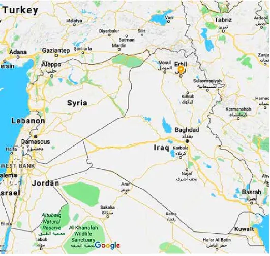
Erbil’s economy depends on agriculture, tourism and small businesses. Also, due to the security and stability of the city it has attracted investment from other cities in Iraq. In addition, opening Erbil international airport in 2010 gave the city a valuable opportunity by linking it with most of the cities in the Middle East and Europe (Fig. 1).
1 Ministry of Planning, KRG. Kurdistan Region statistics office. http://www.krso.net/Default.aspx
Erbil’s urban form follows a concentric pattern of rings surrounding the historic Citadel (Qala) in the city’s centre (Airinc 2012; Akram et al. 2016). The Citadel is on the UNESCO World Heritage list2 and it is a protected site under the legislation of Iraq and Kurdistan Region. It is considered a special case, having a separate mas- ter plan (the Conservation and Rehabilitation Master Plan for Erbil Citadel) and the buildings within it currently have no residents. During much of the past several millennia the city consisted of the citadel itself. Today, the fortified Citadel town lies physically and symbolically in the middle of the greater city of Erbil. It has an irreg- ular oval shape (the diameters are nearly 430 and 340 metres) in plan and is elevated about 30 metres above the ground level (Akram et al. 2016).
2 https://whc.unesco.org/en/list/1437
Figure 1. Location of Erbil City Iraq (source: www.google.com/maps)
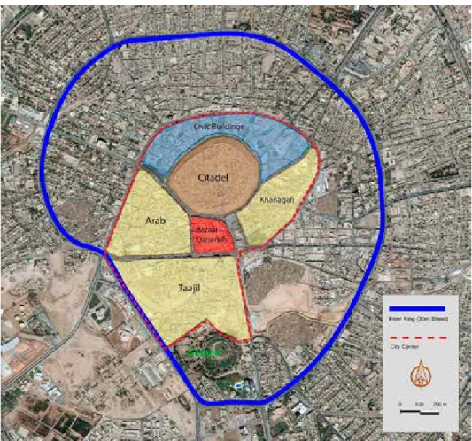
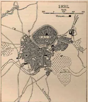
The city centre also includes three other neighbourhoods, which are Taajil, Arab and Khanaqah.
The buildings in the Khanaqah neighbourhood are derelict, and as in the Citadel, they are uninhabited. Since one of the aspects of sustainability concerns social den- sity, because of the lack of inhabitants these two neighbourhoods are excluded from the analysis. The other two neighbourhoods – Taajil and Arab – emerged below the Citadel in the late eighteenth century and since they represent the lively part of the city centre, they were chosen as the subject of the case study (Fig. 2).
The urban form in these neighbourhoods is the result of a certain lifestyle of the people who inhabited this area, reflecting their social, economic and environmental needs. The area has maintained its overall urban form and its architectural character over the past two centuries, although, like in most other historic cities, there have
Figure 2. City centre of Erbil (source: by Rebaz Khoshnaw)
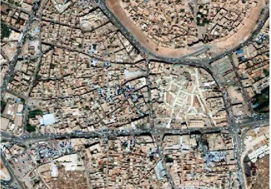
been some rebuilding and new additions in the past. Yet, it has preserved its essential physical elements such as its edges, urban pattern, mixed land use and the architec- tural style of the open courtyard houses. By observing the plan of this area we can discover that the urban fabric is similar to most of the traditional cities in the Middle East. It fits into the pattern described by Atash as follows: “The urban fabric of old- er cities in the Middle East and Northern Africa has changed drastically over the centuries. The medieval Islamic cities in the region had an organic urban fabric which exhibited a high degree of cultural identity and unity” (Atash 1993). For in- stance, Aleppo in Syria is also a city with an ancient citadel in the centre surrounded by traditional neighbourhoods which, as in Erbil, are characterized by organic shapes and open courtyard houses. Baghdad, likewise, is another example of organic urban fabric in the Middle East. “In 1900s, Baghdad was generally held to be the arche- typical organic city in the Arab-Islamic environment. Built by the influences of so- cio-cultural traditions and economic processes without the pre-planned design”
(Alobaydi–Rashid 2017). (Figs 3–5)
The houses usually closely linked, or attached wall to wall in the case of courtyard structures, the inward-oriented courtyards are visually protected from the street. The
Figure 3. Erbil, aerial view (source: Ministry of Municipality-KRG)
Figure 4. Aleppo, aerial view
(source: archnet.org, https://archnet.org/collections/151/media_contents/91323)
Figure 5. Baghdad, aerial view
(source: google map, https://www.google.co.uk/maps/@33.346089,44.3927589,746m/data=!3m1!1e3)
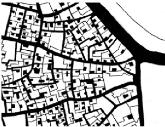
old city centre represents a unique organic urban fabric and network, connecting public and private spaces through narrower alleys (Fig. 6). Building facades are built of various materials and in different styles that can provide protection from sun and rain (Figs 7–8).
Figure 6. Urban structure showing public and private hierarchy – Arab District (source: by Rebaz Khoshnaw)
Figures 7–8. Materials and styles
(source: Erbil Master Plan Report. 2009, Ministry of Municipality-KRG)
This paper was developed in order to enhance the concept of sustainability in this area and identify the aspects of the sustainability of these neighbourhoods.
URBAN FORM AND URBAN MORPHOLOGY
Morphology is the study of shapes and forms3, a branch of theoretical sciences describing, classifying and investigating the rules of form4. Others define it as a method of studying the laws guiding the internal organisation and formation of struc- tures.
Urban morphology studies the functional contents, internal structural characteris- tics and rules connected to forms. Today – depending on professional position – mor- phological analysis can mean studying the relationship between the city and topog- raphy, landscape and terrain features, the spatial representation of social stratification or urban patterns of buildings, structures, blocks and squares. However, these differ- ent approaches are usually applied to observe and analyse the heavily interconnected events of urban growth, even if their interpretations differ (Kissfazekas–Gurdon 2014).
Morphology has undergone significant transformation in its approximately 120- year history. As different scientific disciplines using it have mutually affected each other, it has become increasingly complex and interdisciplinary.
The analytic method5 called “Conzenian Urban Morphology”, established by M. R. G. Conzen, founder of the British school, was further developed by urban and historical geographer J. W. R. Whitehand. Whitehand abandoned the previous – oc- casionally formalist – definition of urban morphology and focused instead on urban economics; he studied the dynamics of the interactions between city and citizens, as well as city and industry. His works further refined the approach of urban morphol- ogy (Moudon 1997; Whitehand 2001).
Frey has pointed out that it is important to take into account that due to a number of place-specific factors such as topography, history, climate, or socio-economic conditions all cities are different in form and structure. Consequently, it cannot be expected that they will all fit in the same formula when it comes to the question of a sustainable city form (Frey 1999).
More complex studies aimed at understanding cities focus on built elements, as the tangible, physical product of social and economic forces. Urban elements (hous- es, streets, squares, parks, the basic units of morphological research) are constantly changing through everyday use. However, they are also in dynamic interaction, transforming themselves and each other. This dynamism of cities is the reason re- searchers of morphology often use the phrase urban morphogenesis instead of urban morphology (Moudon 1997).
3 Tudományos és Köznyelvi Szavak Magyar Értelmező Szótára http://meszotar.hu
4 http://www.kislexikon.hu
5 http://www.birmingham.ac.uk/schools/gees/facilities/conzen-collection/collection.aspx
Different “schools”, coming from different disciplines, all share the ambition to reach a consensus. Regardless of professional or disciplinary background, research- ers strive to find some common denominators. One of the most important common statements, which could even be regarded as a premise of urban morphology is that cities can be read and analysed through their physical shape as a visualisation tool and that the three basic elements of morphological studies are shape, resolution or layering and time (Kissfazekas 2013).
Current international morphological studies follow three main directions. The so- called “theory of city building” seeks answers to the question “why and how were cities built”. The “theory of design as idea, as practised” focuses on determining the impact of previous design theories on morphology. Followers of the “theory of city design” consider “how cities should be built” to be the basic question, taking it as a prescriptive trend, but firmly grounded in urban design and art history.
This present paper does not wish to provide a detailed urban morphological anal- ysis. Of the research directions mentioned above, it can primarily align with the priorities of the theory of city design as a research method. It treats morphology as the spatial, formal imprint of the interactions of historical/social/economical process- es, influenced by a variety of factors. It may help pinpoint the elements of urban history worthy of preservation for the sake of liveability and sustainability and pat- terns defining local identity that can serve as a basis for the future of urban design.
THE GENERAL PRINCIPLES OF THE SUSTAINABILITY AND DESIGN CONCEPTS OF SUSTAINABLE URBAN FORM
“UN-HABITAT, which is the United Nations’ programme aimed at a better urban future, the mission of which is ‘to promote socially and environmentally sustainable human settlements development and the achievement of adequate shelter for all’ have set up some fundamental principles to achieve sustainable neighbourhood plan- ning.”6
a) Adequate space for streets and an efficient street network: At least 30% of the land should be dedicated to street networks and at least 18 km of street length per 1 km2. The goal is to provide adequate spaces not only for vehicles but also for walking and cycling and to achieve social interaction, public safety and access to amenities.
b) High density: At least 15,000 people per km2, that is 150 people/ha. Achieving high density will prevent urban sprawl, decrease the cost of public services, reduce car dependency and enhance energy efficiency.
c) Mixed land-use: The economic use should occupy at least 40% of the floor area.
The infrastructure benefits are the reduction of the overall demand for commuter travel and shortening of average trip lengths. In addition it minimizes road infra-
6 https://unhabitat.org/un-habitat-at-a-glance/
structure requirements. Mixed land use also stimulates the use of public transport, walking and cycling. Moreover, economically mixed land-use increases business activities and therefore has a positive effect on property values.
d) Social mix: The availability of housing in different price ranges to accommodate residents with different incomes. To achieve this, 20–50% of the residential floor area should be reserved for low cost housing, and no tenure type should exceed 50% of the total. The main benefit of social mix is the improvement of accessibi- lity to services and urban amenities for a larger number of population. In addition, it increases housing options for diverse household types.
e) Limited land-use specialization: Less than 10% of any neighbourhood should be allocated to single function blocks. This is an urban planning tool to guarantee the implementation of mixed land-use and it will lead to greater economic diversity.
Many scholars and researchers have tried to define the link between design concepts and sustainable urban form (Jabareen 2006; Jenks–Jones 2010). Jenks and Jones claim that urban form is related not only to physical features but also includes non-physical aspects such as density. According to them, sustainable urban form generally involves physical features including size, shape, scale, density, land uses, building types, urban block layout, as well as the distribution of green space and non-physical characteristics. Thus, they define five inter-related elements that make up urban form (Jenks–Jones 2010).
– Transport/ Infrastructure – Land Use
– Layout
– Housing/ Building Type – Density
Perhaps Jabareen’s7 theory of sustainable urban concepts is the most complex and comprehensive model; it identifies seven concepts related to sustainable urban form (Jabareen 2006):
– Compactness – Sustainable transport – Mixed land use – Density – Diversity
– Passive Solar Design – Greening
7 Yosef Rafeq Jabareen, a researcher and assistant professor at Faculty of Architecture and Town Planning, Israel Institute of Technology. He was a visiting scholar and a lecturer in the Department of Urban Studies and Planning at MIT – Massachusetts Institute of Technology. His works focus on urban planning, risk, and clima- te change.
FEATURES OF THE MOST RELEVANT ASPECTS RELATED TO SUSTANIBILITY
Compactness
The general idea of the compact city envisions strategies that aim to promote high-densities, mixed uses and high-intensification (Jabareen 2006, Burton 2002).
Compactness in spatial designing is a method to achieve more sustainable urban form. It can reduce energy consumption – which subsequently increases econom- ic viability because infrastructure, such as roads and street lighting, can be provid- ed cost-effectively per capita. In addition, population densities are sufficient to support local services and businesses (Williams 2004). Moreover, it reduces the time needed for commuting. This method or strategy depends on increasing densi- ty and at the same time it encourages walkability instead of car dependency. Yet, it helps the establishment of needed services and amenities nearby to create a vi- brant urban life.
Thus, there is a difference in the concept of compactness in the West and the Middle East because of the differences in the factors mentioned earlier (Szabó 2012).
The social interaction in the Middle Eastern context between the local communities is still more intense than in the countries of Europe characterised by modern urban lifestyles. In addition, densities which in some Middle Eastern neighbourhoods can be considered as normal might not be socially acceptable for European urban com- munities.
Sustainable transport
Another important concept related to sustainable urban form is transportation.
Sustainable transportation supports the economy and if it is cost efficient it is also affordable for the majority of the society. In addition, it should be accessible, safe, secure and environmental friendly. Salat8 describes sustainability as a complex no- tion, as long as it is depending on an economic model and energy resources in addi- tion to cultural habits and social behaviour. “It is necessary to have a whole range of transport modes that can be adapted to the different needs of a modern and mobile population” (Salat et al. 2011). The review of relevant literature offers a similar view regarding sustainable transportation: “transportation services that introduce all the community and environmental costs of their reserves; that regard carrying capacity;
and let the needs for flexibility and safety be stable with the needs for access, envi- ronmental worth, and neighbourhood liveability” (Jordan–Horan 1997). The link between sustainable urban form and transportation is defined by Elkin, McLaren and Hillman as follows: “Sustainable urban form must be a form and scale appropriate
8 Serge Salat, author, architect and urban Planner. President at Urban Morphology and Complex Systems Institute, Urban Expert at International Organisations, Board Member at Lab Bpifrance.
to walking, cycling, and efficient public transport and must have a compactness that encourages social interaction” (Elkin et al. 1991). Handy, analysing the main fea- tures of traditional neighbourhoods, claimes that “residents in traditional neighbour- hoods, characterised by higher densities, better accessibility and pedestrian-friendly design exhibited more sustainable travel behaviour than residents of neighbourhoods with lower densities, poor accessibility and pedestrian unfriendly design” (Handy 1996).
Mixed land use
Mixed land use has a great role in achieving sustainable urban form through pro- viding diversity of functions such as residential, commercial, cultural and industrial.
The availability of these services in convenient distances is of paramount importance.
The accessibility of residents to services and daily facilities depends on two main aspects of sustainability; high-density and mixed-use (Jenks–Dempsey 2005).
Also, the correlation between the mixed land use and the three pillars of sustain- ability is defined by Grant: “Mixing uses forms part of a strategy of sustainable de- velopment as well as a theory of good urban form, with the objectives of economic vitality, social equity and environmental quality.” Grant (2002) identifies three con- ceptual levels of mixing uses:
– Increasing the intensity of land uses (variety in residential types) – Increasing the diversity of uses (mixing commercial with residential)
– Integrating formerly segregated uses (allowing light industry in residential areas)
Density
Density and dwelling type affect sustainability through differences in the con- sumption of energy, materials, land for housing, transportation, and urban infrastruc- ture (Walker–Rees 1997). In addition, density is one of the main aspects defining urban form (Bramley–Power 2009). According to (Salat– Ollivier 2017) the role of high density is to create more efficient land use that will make it easier to provide public services and facilities, it also reduces infrastructure costs and maximizes the effectiveness of public transport while minimizing the distance between sites of day- to-day activities. Furthermore, the city’s social and cultural activities depend on density, proximity and choices. These factors facilitate the “production” of culture as much as its “consumption” (Haughton–Hunter 1994).
What is worth mentioning in this research are the differences between social be- haviour in Erbil and social behaviour in a European city. Families in Erbil tend to live in private independent houses rather than apartments. People in Erbil used to have their own small garden that provides privacy for the family, while if living in apartments they have to share some facilities with other inhabitants. This social be- haviour affects density because of the lack of vertical housing and consequently
causes urban sprawl. A UN-Habitat report9 stated that all Iraqi cities, including Baghdad and provincial centres, adopt a horizontal housing pattern (caused by the nature of the conservative societal fabric and land subdivision and allocation laws).
Diversity
Diversity of activities is essential to the sustainability of cities. For Jacobs diver- sity is a vital factor and a multidimensional phenomenon which includes a variety of housing types, building densities, cultures, etc. Walking reflects the level of diversi- ty: the more diverse activities are in a neighbourhood the more walking is there.
Having a diverse neighbourhood will encourage even those people who come by vehicles to get off and enjoy lively urban life by walking (Jacobs 1961).10 Organic cities and neighbourhoods were always examples of this successful diversity. As these neighbourhoods attained their form prior to the introduction of cars, most of their necessary services had been established within walking distances. Thus, the residents successfully created diverse and mixed-use communities.
“Sustainable development and organic city theory both conceptualize the settle- ment as a whole, and both develop within a holistic paradigm where the elements or parts of the city are not strictly separate but supportive. The organic city as an idea has the delight, diversity and subtlety of the natural world. It is, indeed, a part of nature.” (Moughtin 1999)
Municipalities can always play a great role in the support of diversity at neigh- bourhood level through planning. However, planning at the neighbourhood scale was always positively related to the availability of municipal funds (Talen 2008).
Passive Solar Design
Another aspect that is crucial in achieving sustainable urban form is passive de- sign. Passive design in buildings refers to architecture that reduces energy consump- tion through techniques that are based on natural resources. Design, sitting, orienta- tion, layout, and landscaping can make the optimum use of solar gain and microcli- matic conditions to minimize the need for space heating or cooling of buildings by conventional energy sources (Owens 1992). Some design parameters summarized by Yannas (Yannas 1998) which can help to improve urban microclimate and achieve environmentally sustainable cities are:
9 National Report of the Republic of Iraq for Habitat III 2016, http://habitat3.org/the-new-urban-agenda/
preparatory-process/national-participation/iraq/
10 Jane Jacobs (1916–2006) was an urbanist and activist. In her famous book The Death and Life of Great American Cities, 1961, she argued that cities have their own integrated system and dynamics. She also intro- duced the sociological concept in urban planning.
– built form density and type, to influence airflow, view of sun and sky, and exposed surface area;
– street canyon width to height ratio and orientation, to influence warming and cooling processes;
– building design, to influence building heat gains and losses;
– urban materials and surface finishes to influence absorption, heat storage, and emissivity;
– vegetation and bodies of water, to influence evaporative cooling processes on building surfaces and/or in open spaces;
– traffic reduction, diversion, and rerouting to reduce air and noise pollution and heat discharge;
However, there is significant deference between the concept of passive solar design in the Middle East and Europe. In Erbil, the concept and the techniques are more about cooling the houses in summer and reducing direct exposition to sunlight. In cold climates the established techniques are aimed at getting the most of sunlight and heat during the winter. In addition, some modern solar systems with sophisticated technology can almost entirely eliminate a house’s need for energy, yet with a high initial cost.
Greening
Greening seeks to embrace nature as integral to the city itself and to bring nature into the life of city dwellers through a diversity of open landscapes (Elkin at al.
1991). Also, greening in urban development contributes positively to biodiversity, enhancing the quality of air. In traditional urban neighbourhoods of developing cities (especially in hot dry climates), greening has always been an essential method to moderate the microclimate of open courtyard houses. In addition, greening contrib- utes to sustainable development via enhancing the image of the urban area and qual- ity life. Moreover, it has a role in increasing the economic attractiveness of a city and fostering community pride (Beer et al. 2003). Greening also has an educational function as a symbol or representation of nature (Forman 2002).
THE URBAN MORPHOLOGY AND SUSTAINABILITY OF THE HISTRORICAL PARTS OF ERBIL
Erbil’s main morphological characteristics
Erbil’s main urban structure is a ring-radial system. In the master plan of the in- tensively developing city it is decided to continue the same system in the future as well (Fig. 9). The historical parts of Erbil consist of the citadel and the organic urban fabric surrounding it, the Taajil, Arab and Khanaqah neighbourhoods and the
Qaisariah bazaar. These quarters with a civic area located northeast of the present city centre.
The citadel itself dates back to the Sumerian era, while the three neighbourhoods are believed to be from the late eighteenth century. The other quarters inside (30 m) streets were built between 1920 and 1958 (Figs 10–11). The urban fabric of the his- toric part is characterized by open courtyard houses and narrow irregular streets.
Modern architecture and new urban design trends have also affected the urban fabric of the city, thus diagonal and grid patterns characterize the new quarters.
Erbil city centre is an example of an organic city and it continued to preserve its organic growth in the areas below the citadel up until the twentieth century. The later growth of the city has seen changes during the early years of the twentieth cen- tury (after the establishment of the state of Iraq in 1920) due to changes of social and economic conditions. During this period, people started to adopt a modern lifestyle and the introduction of cars required wider streets. In addition, the appearance of new construction materials demanded totally new urban patterns.
Figure 9. Erbil master plan 2009 (source: Ministry of Municipality-KRG)
Figure 10. Aerial photo of Erbil 1919 (source: UCL Institute of Archaeology)
Figure 11. Erbil 1944 (source: Iraq and the Persian Gulf, Great Britain. Naval Intelligence Division)
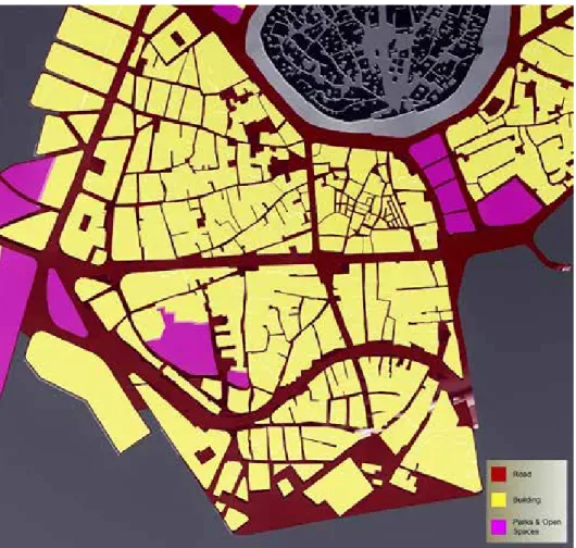
Context of the two neighbourhoods and their morphological characteristics Both neighbourhoods have an organic structure and were formed during the same period (Fig. 12). Arab is considered a residential neighbourhood with a large number of heritage buildings, most of which are in poor physical conditions. The residential fabric is surrounded by commercial parts. The most frequent building type is the house with open courtyards (providing private space) (Fig. 13). The urban fabric of the Taajil neighbourhood is also in poor condition with even more derelict buildings and smaller lot areas (Fig. 14). A wide curved street running through this neighbour- hood gives this area greater potential to be greener and to accommodate a more liveable community (Table 1).
Figure 12. Formal land-use in the study area (source: Rebaz Khoshnaw)
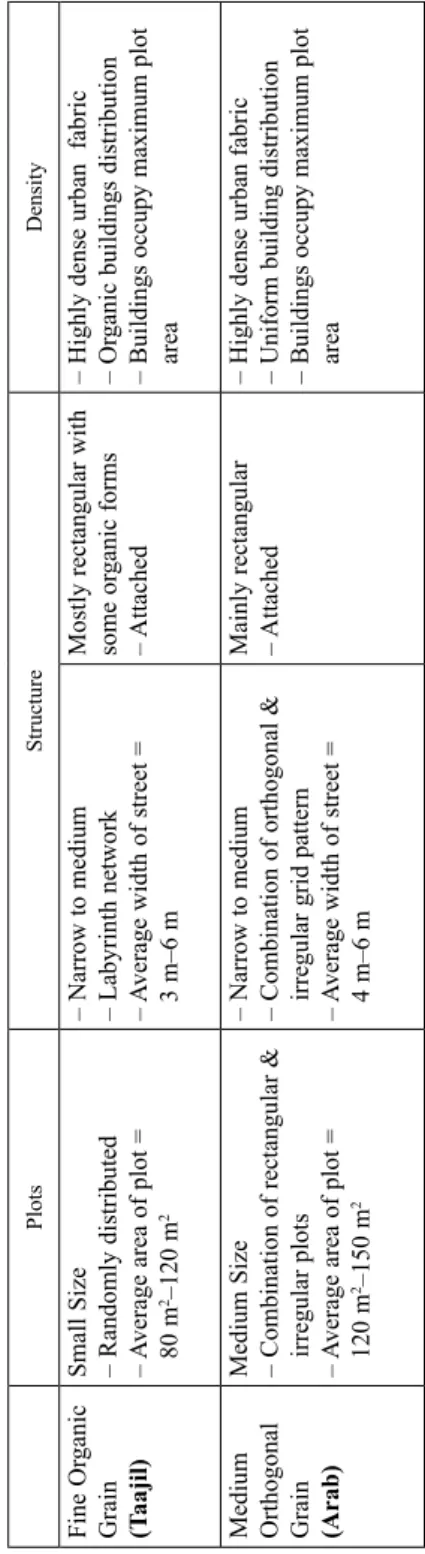
Table 1. The most important characteristics of the urban fabric (source: Erbil master plan report, 2009. Ministry of Municipality-KRG) PlotsStructureDensity Fine Organic Grain (Taajil)
Small Size – Randomly distributed – Average area of plot = 80 m2–120 m2
– Narrow to medium – Labyrinth network – Average width of street = 3 m–6 m
Mostly rectangular with some organic forms – Attached – Highly dense urban fabric – Organic buildings distribution – Buildings occupy maximum plot area
Medium Orthogonal Grain (Arab)
Medium Size – Combination of rectangular & irregular plots – Average area of plot = 22120 m–150 m
– Narrow to medium – Combination of orthogonal & irregular grid pattern – Average width of street = 4 m–6 m
Mainly rectangular – Attached– Highly dense urban fabric – Uniform building distribution – Buildings occupy maximum plot area
Features of urban form and sustainability in the case studies
The aim of this chapter is to analyse Erbil’s morphological features according to the aspects of sustainability presented above.
a) Compactness
The harsh and hot climate during the summer led the residents of these two neigh- bourhoods to arrange their houses adjacent to each other in order to provide protec- tion from direct sunlight and heat besides getting narrow shaded alleys during the day. In this way not only did they improve the efficiency of the alleys to maintain low temperature, but also managed to ensure a comfortable air flow. Moreover, the mixed land use ensuring a variety of activities within walking distance, they en- hanced the compactness of the urban fabric (Table 2). However, the poor physical condition of the buildings and the old infrastructure is limiting the level of compact- ness in these two neighbourhoods.
b) Transportation
The urban fabric in the Taajil and Arab neighbourhoods has an organic structure, with connected networks of narrow alleys and streets. Wider modern streets surround the area and the two neighbourhoods are accessible by pedestrians from all sides.
Hence, the movement network can be considered as a fully integrated system that
Figure 13. Structure of the Arab neighbourhood Figure 14. Structure of the Taajil neighbourhood (source: Erbil master plan report, 2009. Ministry of Municipality-KRG)
Table 2. The area and length of the street network (source: Rebaz Khoshnaw) Area (m2) Street network (m2) Street network length
(m) Street network %
Taajil 251,000 55,177 6,883 21.98
Arab 149,000 31,973 4,209 21.45
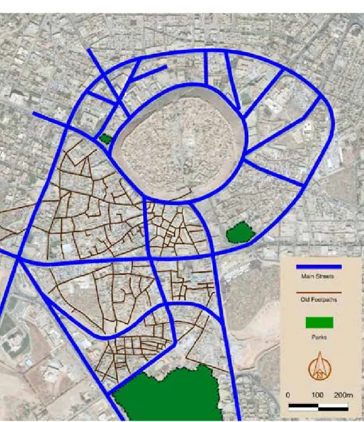
Figure 15. Main streets and old footpaths (source: by Rebaz Khoshnaw)
connects these two neighbourhoods with each other as well as with the surrounding commercial area. However, the streets around the area and below the citadel are mainly used by private cars (Fig. 15). Consequently, the walking experience is inter- fered by car traffic and some vacant lots inside the area are used as car parks that makes walking and cycling an inconvenient experience. The street networks repre- sent 21.98% and 21.45% for Taajil and Arab, respectively, which is still below the 30% recommended by UN-HABITAT. However, the length of the street networks exceeds the recommended 18 km length for every 1 km2 (Table 2; Fig. 15).
c) Mixed Use
Both neighbourhoods are characterized by mixed vernacular fabric and offer the residents and visitors a variety of choices. The two neighbourhoods are surrounded by commercial streets and they are adjacent to the traditional bazaar (Qaisariah).
Figure 16. Commercial Area in the city centre (source Ministry of Municipality-KRG)
The commercial area includes retailers, groceries and business offices within a walking distance. The wide curved streets (25–35 m) running through Taajil provide a potential for a more vibrant mixed-use neighbourhood (Fig. 16). Commercial land use represents 26% of the area of Taajil whereas in Arab this figure is slightly low- er with only 20.13%, and in both cases the percentage is lower than 40% (Table 3;
Fig. 16).
d) Density
The number of the population in these two neighbourhoods has always been fluc- tuating. With the continuous growth of Erbil city after the second half of the 20th century some of the local families moved out to other newly built neighbourhoods and subsequently tenants with lower incomes settled in the area. In addition, being located in the city centre these two neighbourhoods were always losing residential buildings to the benefit of commercial use. The last formal and reliable survey con- ducted in 2010 shows that the Taajil neighbourhood had a population of 10,200, while Arab had 5,800 inhabitants (Table 4).
In 2010 the gross density of Taajil was 406 p/ha and in Arab it was 389 p/ha which is (in both neighbourhoods) more than 150 p/ha, the ratio which the UN-Habitat claims maximizes land efficiency.
Table 3. Total and commercial area of the two neighbourhoods (source: Ministry of Municipality-KRG) Area (m2) Commercial Floor Area (m2) Percentage
Taajil 251,000 65,480 26%
Arab 149,000 30,000 20.13%
Table 4. Population of the two neighbourhoods (source: Ministry of Municipality-KRG)
Taajil Arab
1997 10,439 –
2010 10,200 5,800
e) Diversity
Besides having residential and commercial land use, the area has different housing types and sizes in addition to a rich architectural and cultural heritage. However, what is worth mentioning is the lack of daily maintenance and the bad situation of infra- structure and buildings that is not encouraging residents with higher incomes to stay in this area. The residents of both neighbourhoods are families with lower incomes which makes this aspect of sustainability almost non-existent.
f) Passive Solar Design
The vernacular architecture of the urban fabric in the study area contributes posi- tively to the idea of passive solar design during the day. The buildings in this area are characterized by three aspects, which enhance the notion of passive solar design.
– The streets and alleys have narrow width that provides shades and helps cooling the air;
– The building type of the house with open courtyards with garden inside creates a moderate and comfortable microclimate for the residents. Having shaded alleys and open surfaces exposed to direct sunlight creates differences in temperature.
Subsequently, it causes different air pressure that generates a smooth flow of cool air in the area.
– The use of local materials (such as locally made bricks) reduces the heat received from the sun.
g) Greening
Most of the houses of these neighbourhoods have gardens in their open courtyards which is essential in moderating the microclimate of the buildings. Yet, there is a lack
Table 5. The existing level of sustainability aspects according to Jabarreen’s theory.
High level: should be preserved. Moderate and Low: needs improvement
Arab Taajil
Compactness Moderate Moderate
Sustainable transport Low Moderate
Mixed land use Moderate Moderate
Density High High
Diversity Low Low
Passive Solar Design High High
Greening Low Moderate
of green surfaces and trees along the sidewalks (Fig. 15). By and large, the environ- ment in the city centre is less clean and healthy as it used to be due to the large number of cars and also because of the lack of adequate public parks. However, the Taajil neighbourhood is adjacent to a public park (called Gilkand) and has a potential to have a green network. The Arab neighbourhood has a more compact physical structure with limited open spaces.
CONCLUSION
In developing countries the vernacular architectural styles, the typology of the buildings and the urban form were always considered to be in a great level of sus- tainability.
This research took two distinctive neighbourhoods in the city centre of Erbil to examine their aspects of sustainability. In recent years, the growth of the population and the increase in the numbers of vehicles affected all aspects of social, economic, and environmental life, consequently also the built environment in the city centre.
The study found that the urban form of these neighbourhoods have preserved their unique organic urban form. However, there are major problems that are threatening their urban fabric and their sustainable built environment. The results in Table 5 show that four aspects of sustainability (Compactness, Mixed use, Density and Passive Solar Design) are prevailing in the area, whereas other three aspects (Sustainable Transport, Diversity and Greening) are in strong need of improvement. Table 6 shows the current situation of these two neighbourhoods according to the UN-HABITAT’s principles to achieve a sustainable neighbourhood. For Street Network and Density both are demonstrating a high level, while for Mixed Land-use aspect they are sim- ilarly in moderate level. The Social Mix aspect cannot be evaluated currently as the majority of the residents are families with low income, regardless of the location of the houses, due to the lack of services and infrastructure. In the fifth aspect both neighbourhoods similarly show high percentage of commercial and residential blocks, since the area consists of traditional buildings with one or two floors and they fulfil either residential or commercial function.
The heavy road traffic in the city centre is one of the threats, as it is weakening the sense of place and safety in addition to the lack of green network and public parks.
Furthermore, the research concluded that the area is in urgent need of a renewed infrastructure and services as well as of an efficient management.
City management has a high responsibility for the sustainability of the settlement as well.
Considering Erbil’s features the following recommendations can be made:
1. To achieve sustainable transportation in the area it is of paramount importance to:
• Enhance public transport and connect the area with other parts of the city.
• Provide parking facilities outside the area to help the limitation of vehicles and to encourage walkability.
Table 6. A comparison of sustainability aspects between the UN-HABITAT’s principles to achieve sustainable neighbourhood planning with the existing situation of these two neighbourhoods UN-HABITAT’s principlesArabTaajil Street Network: Dedicating 30% of the land to street networks and at least 18 km of street length per 1 km2Street are: 21.45% Street length: 28.24 Km per 1Km2Street are: 21.98% Street length: 27.4 km per 1 km2 High density: At least 15,000 people per km2, that is 150 people/ha.389.2 People/ha406.3 People/ha Mixed land-use: The economic use should occupy at least 40% of the floor area.20.13%26% Social Mix: 20–50% of the residential floor area should be for low cost housing.N/A as the majority of the households are low income families due to lack of services and deteriorated infrastructure.
N/A as the majority of the households are low income families due to lack of services and deteriorated infrastructure. Limited land-use specialization: Less than 10% of any neighbourhood should be allocated to single function blocks.
Commercial: 20.13% Residential: 50+%Commercial: 26% Residential: 50+%
• To achieve pedestrian-friendly and liveable neighbourhoods, the creation of a green network must be taken into consideration, one that connects the open spaces and parks in both neighbourhoods with each other.
2. By having the citadel in the centre, the city is considered as a tourist destination.
This must be supported by creating open spaces, cultural centres and commercial tourist venues and most importantly by renewing the infrastructure of the area in order to enhance the aspects of diversity.
In this paper the authors’ intention was to analyse the sustainability of Erbil’s histo- rical quarters. The next step of the research will be the study of a larger area of Erbil, including its newly developed neighbourhoods, evaluating their aspects of sustaina- bility. Hence, the aim is to have a broader understanding of the sustainable urban form of the city (as an example for developing cities).
REFERENCES
Akram et al. 2016
Akram, O. K. – Ismail, S. – Franco, D. J.: The Significant of Urban Form of Erbil City, Iraq.
International Journal of Engineering Technology, Management and Applied Sciences 4 (2016) 2.
97–100. ISSN 2349-447. www.ijetmas.com
https://www.researchgate.net/publication/299992594_The_Significant_of_Urban_Form_of_
Erbil_City_Iraq (accessed 28 August 2018) Alobaydi–Rashid 2017
Alobaydi, Dhirgham – Rashid, Mahbub: A Study of the Morphological Evolution of the Urban Cores of Baghdad in the 19th and 20th Century. Paper presented to the 11th International Space Syntax Symposium, at Instituto Superior Técnico, University of Lisbon, Lisbon, 3–7 July 2017.
http://www.11ssslisbon.pt/proceedings/cities-and-urban-studies/ (accessed 28 August 2018) Atash 1993
Atash, F.: Fragmentation of the Urban Fabric. Experience of the Middle Eastern and North African Cities. Cities: The International Journal of Urban Policy and Planning 10 (1993) 4. 313–325.
Beer et al. 2003
Beer, A. – Delshammar, T. – Schildwacht, P.: A Changing Understanding of the Role of Greenspace in Highdensity Housing. A European Perspective. Built Environment 29 (2003) 2.
132–143.
Bramley–Power 2009
Bramley, G. – Power, S.: Urban Form and Social Sustainability. The Role of Density and Housing Type. Environment and Planning B: Planning and Design 36 (2009) 1. 30–48.
Burton 2002
Burton, E.: Measuring Urban Compactness in UK Towns and Cities. Environment and Planning B: Planning and Design 29 (2002) 2. 219–250.
Elkin et al. 1991
Elkin, T. – McLaren, D. – Hillman, M.: Reviving the City: Towards Sustainable Urban Development. Friends of the Earth, London 1991.
Forman 2002
Forman, R.: The Missing Catalyst. Design and Planning with Ecology. In Bart T. Johnson – Kristina Hill (eds): Ecology and Design: Frameworks for Learning. Island Press, Washington DC 2002.
Frey 1999
Frey, H.: Designing the City: Towards a More Sustainable Urban Form. E & FN Spon P26, London 1999.
Grant 2002
Grant, J.: Mixed Use in Theory and Practice. Canadian Experience with Implementing a Planning Principle. Journal of the American Planning Association 68 (2002) 1. 71–84.
Handy 1996
Handy, S.: Methodologies for Exploring the Link between Urban Form and Travel Behaviour.
Transportation Research – D 1 (1996) 2. 151–165.
Haughton–Hunter 1994
Haughton, G. – Hunter C.: Sustainable Cities. Jessica Kingsley, London 1994.
Ismael–Ngah 2010
Ismael, A. K. – Ngah, I.: Urban Planning for Small and Medium Cities in Kurdistan Region-Iraq.
International Journal of Engineering Science 2 (2010) 12. 7070–7077.
Jabareen 2006
Jabareen, Y. R.: Sustainable Urban Forms. Their Typologies, Models, and Concepts. Journal of Planning Education and Research 26 (2006) 1. 38–52.
Jacobs 1961
Jacobs, J.: The Death and Life of Great American Cities. Random House, New York 1961.
Jenks–Dempsey 2005
Jenks, M. – Dempsey, N.: Future Forms and Design for Sustainable Cities. Architectural Press, Oxford 2005.
Jenks–Jones 2010
Jenks, M. – Jones, C.: Dimensions of the Sustainable City 2. Springer Science & Business Media, London, New York 2010.
Jordan–Horan 1997
Jordan, D. – Horan, T.: Intelligent Transportation Systems and Sustainable Communities Findings of a National Study. Paper presented at the Transportation Research Board 76th annual meeting, Washington DC, 12–16 January 1997.
Kissfazekas 2013
Kissfazekas, K.: The Urban Context of the State Socialist Public Building Complexes. Építés – Építészettudomány 42 (2014) 1–2. 93–132. DOI: 10.1556/EpTud.2013.001
Kissfazekas–Gurdon 2014
Kissfazekas, K. – Gurdon, B.: A várostest morfológiája. Építés – Építészettudomány 42 (2014) 3–4. 173–205.
KRG 2013
The People of the Kurdistan Region. Kurdistan Regional Government from http://www.krg.org/
p/p.aspx?l=12&s=020000&r=304&p=214 (accessed 28 August 2018) Morris 1994
Morris, A. E. J.: History of Urban Form before the Industrial Revolution. Wiley & Sons, New York 1994.
Moudon 1997
Moudon, A. V.: Urban Morphology as an Emerging Interdisciplinary Field. In Urban Morphology I. (1997) 3–10. http://www.urbanform.org/online_unlimited/um199701_3-10.pdf (accessed 28 April 2018)
Moughtin 1999
Moughtin, C.: Urban Design: Method and Techniques. Architectural Press, Oxford 1999.
Owens 1992
Owens, S.: Energy, Environmental Sustainability and Land-Use Planning. In Michael Breheny (ed.): Sustainable Development and Urban Form. Pion, London 1992. 79–105.
Salat–Ollivier 2017
Salat, S. – Ollivier, G.: Transforming the Urban Space through Transit-Oriented Development:
The 3V Approach. World Bank Group, Washington D.C. 2017.
Salat et al. 2011
Salat, S. – Labbé, F. – Nowacki, C.: Cities and Forms, on Sustainable Urbanism. Hermann, Paris 2011.
Szabó 2012
Szabó, Á.: A városok fenntarthatóságának egyes szempontjai. In: Élhető települési táj.
Településépítészeti tanulmányok. Corvinus Egyetem, Budapest 2012. 91–105.
Talen 2008
Talen, E.: Design for Diversity. Exploring Socially Mixed Neighborhoods. Elsevier, London 2008.
UN-HABITAT
Urban Planning for City Leaders. UN-HABITAT, Nairobi 2012.
Walker–Rees 1997
Walker, L. – Rees, W. E.: Urban Density and Ecological Footprints. An Analysis of Canadian Households‘. In M. Roseland (ed.): Ecocity Dimensions. New Society Publishers, Gabriola Isld, BC 1997.
Yannas 1998
Yannas, S.: Living with the City: Urban Design and Environmental Sustainability. In Maldonado Eduardo and Simon Yannas (eds): Environmentally Friendly Cities. James & James, London 1998. 41–48.
Whitehand 2001
Whitehand, J. W. R.: British Urban Morphology. The Conzenian Tradition. Urban Morphology 5 (2001) 2. 103–109.
Williams 2004
Williams, K.: Can Urban Intensification Contribute to Sustainable Cities? An International Perspective. City Matters (2004)
VÁROSFORMA ÉS FENNTARTHATÓSÁG A TÖRTÉNELMI VÁROSOKBAN
ERBIL (IRAK) KÉT VÁROSNEGYEDÉNEK ESETTANULMÁNYA Összefoglaló
Jelen tanulmány egy hosszabb kutatás első lépéseinek egyikeként Erbil központjának két régi város- negyedét vizsgálja a fenntartható városforma szempontjából. A város központjának két negyede jelenleg szinte lakatlan. A másik kettő városnegyed jelenlegi szerkezetét a 19. század alakította; vitális, dinamikus városrészek, amelyeknek az életét jelentősen befolyásolja az egyre növekvő lakosszám és a motorizáció.
A tanulmány a fenntarthatóság, élhetőség és a városmorfológia kérdéskörét kívánja vizsgálni, Erbil fent nevezett két városközponti negyedére fókuszálva. A szerzők a fenntarthatóság különböző kutatók által nevesített szempontjait gyűjtik egybe, összehasonlítva azokat az erbili helyszínek jellemzőivel.
Kulcsszavak: városforma, városmorfológia, fenntarthatóság, történelmi városközpont, Erbil
Received: 1 May 2018. Accepted: 21 June 2018