Mentes Gyula
MTA C K -8. (E-mail:
Mentes.Gyula@csfk.mta.hu) Kivonat
mutatjuk be folyamatos -
magaspart top ai
. A magaspart d a
el. zszint-
magaspart a magasfal
saira magaspart a
magasfal magaspart magaspartban
. Kulcsszavak
Investigating the causes of the high bank movements
Abstract
2016 observed by continuously recording bore- hole tiltmeters. Since hydrological and meteorological processes change rapidly, their effect on the high bank movements cannot be studied on the basis of intermittently repeated geodetic measurements, which are only useful to observe the changes of the topography of the high bank. The tilts of the high bank were measured by two borehole tiltmeters, one was placed on the stable, the other on the moving part of the high bank. The relationships between tilts and temperature, precipitation, the effect of vegetation, as well as the ground water level and the variations of Danube water level were investigated. The connection between tilt values and water level variations was investigated by multivariable and moving window regression analyses. The results show that increasing regression coefficients mean decreasing stability of the high river bank, and so this method can be used for continuous supervision of the high bank stability. Investigations showed clearly that the effect of ground water table variations on the high bank movements is two orders of magnitude higher than the water level variations of the River Danube. The main role of the Danube is the undercutting of the high bank and washing away the loess from the base of the high bank. Besides the erosion of the high bank, the different tilts of the stable and unstable parts also contribute to arising of new cracks in the stable part, decreasing its width.
Keywords
water level, temperature, precipitation, vegetation, tilts of the high bank.
2008. - magaspart
magaspart is
Geo F
K
, a Magya magasfal
, amelyek magaspart
A dunai magaspartok csuszaml
(pl.:
1979, Scheuer 1979, Schwei-
tzer 2001, ). V
is ( ), azon-
ban a magaspart
magaspartok
k, a
magaspartok
rek)
- (Thuro
, Mentes 2012, Lienhart 2015)
ges a magaspartok pontosabb ta-
gyakori terepi
) 2016)
nek fontos szerepe van a magaspart szerek a csak a magaspart
alkalmasak.
(pl.:
Petley 2012),
, melyek azok a folyamatok
rulnak a ,
korai f
hez (pl.: 2016,
Gigli 2016 Pagano 2017, 2017).
Mentes (2017a) magaspartok A jelen
magaspart
hidro- , saira
on-
magaspart megfi-
, alapja lehet nek.
A magaspart Applied
-
, ill.
(1 mm/m) keny
http1). A
http2
(Mentes 2017b). Az kb. 40-
http3).
A http4
kapcsolatot , valamint
1.
- magaspart 2008.
-i rogy a Figure 1
landslide on 12 February 2008. (photo was i on 17 February 2008)
( , S a stabil L, pedig a
magasparton )
(Note: TV1 and TV2 denote the locations of the ground water level measure- ments, while S and L denote the location of the borehole tiltmeters on the stable and moving part of the high bank, respectively.)
magaspart ire Figure 2. The effect of the temperature on the high bank tilts
magaspart magaspart
jelent.)
north and east tilts measured on the moving high bank after subtraction of the trend. The change of the tilt curves in positive direction means northward and eastward tilts.)
A
magaspart . -
2014. december 31-ig.
trendet levontuk
a leveg
. A a
tel
magaspart magaspart
A le-
reg az 1 C
okozott A kapott regresz-
a nagy .
A a 2011.
A stabil magaspart magaspart
Ezt -
( , .
A magaspart magaspart
(pl.:
1999, ).
al
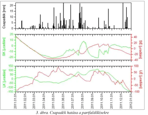
Figure 3. The effect of the precipitation on the high bank tilts
( SK a
)
ction of the trend, respectively. The change of the tilt curves in positive direction means northward and eastward tilts.)
-
let is
( , 2002,
, ,
). a
magaspart Kraft 2009).
(pl.:
Terwilliger 1990, Pollen 2007, Pollen- mon 2010).
ismertetik 2015),
valamint ) csak a
n ko-
zott magaspart uk.
(PET)
, mint pl. a Penman-
szer (Monteith 1965). Ezek azonban olyan bemeneti pa-
Rey 1999)
vesz figyelembe.
A stabilnak te- kintett magaspart
- Men-
), valamint A ben mutatja a PET,
nagyobb,
csa
. A -
- (
1986, ).
magaspart ire.
b) A magaspart
Figure 4. The effect of the vegetation on the high bank tilts. a) Comparison of the PET, precipitation and tilt amplitudes.
b), daily tilts of the high bank.
A Duna szint
magaspart
Az j
magaspart 2013-
magasparton magaspart
-
hason- , amint
az (2013)
5
Figure 5. Water level and tilt data series measured between 1st January 2011 and 31st March 2016.
( magaspart magaspart
. )
(Note: DV is the variation of the water level of the Danube, TV1 and TV2 are the ground water lev
tilts measured on the stable and moving part of the high bank, respectively. The change of the tilt curves in positive direction means northward and eastward tilts.)
Mivel az
sz -1
mutatja, 1-2 n
magaspartra sokkal kisebb, mint a
2013- gasparttal
kapcsolatosak, ami a magaspart A
A
2013-ban mutatja a magaspart a
2010- a
fel ( - -2,5
). 2014- a
ek ( ).
1. t , valamint
Table 1. Regression coefficients between tilt values and Danube water level (DV) as well as ground water levels (TV1 and TV2) -
TV1
-1 TV2
-1 DV
-1 R2
SK 2011 -13 -35 4 0.800
2012 -41 -44 3 0.658
2013 -207 33 -2 0.484
2014 -23 63 2 0.533
2015 2 -37 -1 0.862
2016 13 13 -1 0.789
2011 -193 3 7 0.388
2012 28 -98 -1 0.793
2013 67 -56 1 0.619
2014 0 28 2 0.335
2015 28 -44 -2 0.775
2016 6 -38 -1 0.970
LK 2011 -400 -178 18 0.862
2012 167 95 -8 0.373
2013 369 -83 11 0.733
2014 -156 -1095 15 0.859
2015 334 -2430 40 0.800
2016 -712 1073 53 0.859
2011 185 -287 -16 0.965
2012 33 -512 -6 0.933
2013 -1380 -71 -30 0.690
2014 776 -1198 -22 0.531
2015 25 1246 -208 0.272
2016 -199 114 -36 0.389
( magas magaspart
2 )
high bank, respectively. Positive values mean northward and eastward tilts. R2 shows the goodness of the adjustment.)
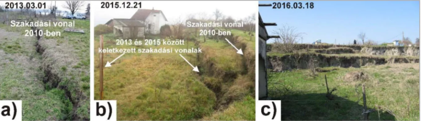
Figure 6. Appearance and development of new cracks on the high bank between 2010 and 2016
( )
(Note: The dates on the photos show the time when the photo was taken. Photos were taken by the author)
magaspart
- a magaspart
on-
magaspart
gyors -
7, 8, 9
nak -
) (LK)
- 9. ). A
magaspart
leg- magaspart
nak )
( ), valamint
magaspart
Figure 7. Relationship between the north tilt component of the stable high bank and groundwater level as well as water level variation
( a stabil magaspart , R TV2 DV
a
)
high bank, the ground water level and the variation
DV are the regression coefficients between the north tilt of the stable high bank and ground water level as well as the water level variations of the Danube.
magaspart
Figure 8. Relationship between the east tilt component of the stable high bank and groundwater level as well as Danube water level variation
( magaspart DV
)
(Note: SK, TV2 and DV denote the east tilt of the stable high bank, the ground water level and the variation of the water level of the Danube. R SK TV2 and R SK DV are the regression coefficients between the east tilt of the stable high bank and ground water level as well as the water level variations of the Danube. The change of the tilt curve SK in positive direction means eastward tilt.)
A magaspart - -ig - magaspart
-ig egyenle-
- -D
- magaspart
magaspart magaspart
magaspart
), hanem a stabil magaspart
magaspart
ft 2009). Ezzel a magaspart
ak- ), amely meg-
magaspart
ro magaspart nagy amp- magaspart
- magaspart
magaspart magaspart sta-
magaspart
Figure 9. Relationship between the north tilt component of the moving high bank and groundwater level as well as Danube water level variation
( magaspart
sa )
DV are the regression coefficients between the north tilt of the moving high bank and ground water level as well as the water level
10 magaspart
Figure 10. Relationship between the east tilt component of the moving high bank and groundwater level as well as Danube water level variation
(
a )
(Note: LK, TV2 and DV denote the east tilt of the moving high bank, the ground water level and the variation of the water level of the Danube. R LK TV2 and R LK DV are the regression coefficients between the east tilt of the moving high bank and ground water level as well as the water level variations of the Danube. The change of the tilt curve LK in positive direction means eastward tilt.)
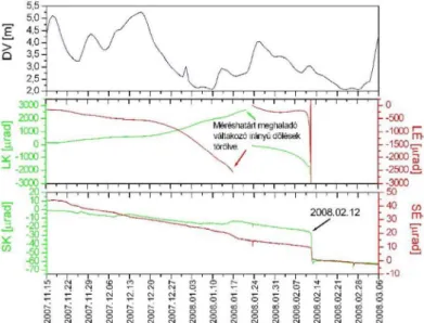
Figure 11. Tilt data measured on the high bank between 15 November 2007 and 6 March 2008
( magaspart
A magaspart 2008. - .)
(Note: change of the tilt
curves in positive direction means northward and eastward tilts. The falling down of the high bank occurred on 12 February 2007)
A
2010
magaspart
A (20-50
-
Figure 12. Tilt data measured on the high bank between 1 March 2008 and 31 December 2010
( magaspart
)
of the tilt curves in positive direction means northward and eastward tilts.)
A magaspart
- -ig az mutatja. A 13.
- (LK-
magaspart
Kraft 2004) 2003-
Kraft 2009).
zek a r
(jobbra) magaspart
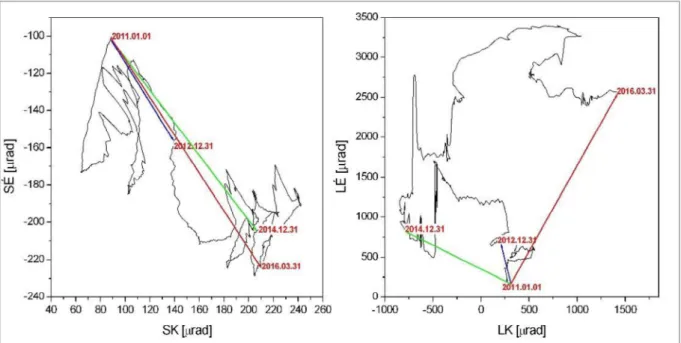
Figure 13. Tilt variation of the stable (left) and the moving (right) part of the high bank between 1 January 2011 and 31 March 2016
( magaspart
)
y. The red arrows show the resultant tilt in the measurement period.)
magaspart a magaspart i folyamata
magaspart
(Note: S and L denote the locations of the tiltmeters, the red arrows show the tilts of different magnitudes and generally different direction causing cracks in the high bank.)
E
- magaspartot
t
magaspart magaspart
nak, amelyek a magaspart a
nagy m
A magaspart
s .
magaspart magaspart
magaspart l
magaspart alatti fel- magaspart
magaspartban magaspart
magaspart magaspart stabil
kelet- ). A fent
magaspart fokozatos magaspart
magaspart
cs
DDOP-2009-
jtott se-
magaspartok a kat tanultam.
(2013). A dunaszek- -
-12), 7-11.
-Ma- http://dok-
tori.nyme.hu/id/eprint/492.
P., (2011). Surface changes on a landslide af- Geosci 3 (2), 119-128. DOI: 10.2478/s13533-011-0014-6.
-422.
Fathani T. F., Karnawati D., Wilopo W. (2016). An in- tegrated methodology to develop a standard for landslide early warning systems. Nat Hazards Earth Syst Sci 16, 2123-2135.
Fox G. A., Wilson G. V. (2010). The role of subsurface flow in hillslope and stream bank erosion: a review. Soil Science Society of America Journal 74, 717-733.
Fumitoshi I., Sidle R. C., Kamei R. (2008). Effects of forest harvesting on the occurrence of landslides and de- bris flows in steep terrain of central Japan. Earth Surface Processes and Landforms 33, 827-840.
Greco R., Pagano L. (2017). Basic features of the pre- dictive tools of early warning systems for water-related natural hazards: examples for shallow landslides. Nat Haz- ards Earth Syst Sci 17, 2213-2227.
uer Gy.
425-440.
Hubble T. C. T., Docker B. B., Rutherford I. D. (2010).
The role of riparian trees in maintaining riverbank stabil- ity. A review of Australian experience and practice. Eco- logical Engineering 36, 292-304.
Intrieri E., Gigli G. (2016). Landslide forecasting and factors influencing predictability. Nat Hazards Earth Syst Sci 16, 2501-2510.
- 20.
(1972). A dunai 15, 71-83.
35-39.
- -64.
-297.
Kleb B., Schweitzer F. (2001). A Duna
MTA, pp. 169-193.
Kraft J.
-es -48.
Kraft J.
B.
- -
104.
-J. (1986). Model calculations for rainfall induced tilt and strain anomalies. In: Vieira, R. (Ed) Proc.
10th International Symposium on Earth Tides, R. Vieira (Ed.), Madrid, 889 901.
-J., Varga P. Lehmann K. Mentes Gy.
(1996). Ground Tilt Induced by Pumping - Preliminary Results from the Nagycenk Test Site, Hungary. Acta Geod. Geoph. Hung, 31(1-2), 67-79.
Lienhart W. (2015). Case studies of high-sensitivity monitoring of natural and engineered slopes. Journal of Rock Mechanics and Geotechnical Engineering 7, 379- 384.
(1989). Landslide haz- ard induced by river undercutting along the Danube. In:
ph
Dinamica Quaternaria, vol. 2, pp. 5-11.
Mentes Gy. (2012). A new borehole wire extensometer with high accuracy and stability for observation of local geodynamic processes. Rev Sci Instrum. 83, 015109. doi:
10.1063/1.3676652.
Mentes Gy.
-39.
Mentes Gy. (2017b). The role of recent tectonics and hydrological processes in the evolution of recurring land-
Geomorphology 290, 200-210.
http://dx.doi.org/10.1016/j.geomorph.2014.04.026 (2012). Relationships between short periodic slope tilt variations and vital processes of the vegetation. J. Appl. Geodesy 6, 83-88.
https://doi.org/10.1515/jag-2012-0009.
(2012). Recurring mass movements on the odetic methods. J. Appl. Geodesy 6, 203-208.
https://doi.org/10.1515/jag-2012-0011.
(2014). Small slope tilts caused by meteorological effects and vital pro- gary. Geomorphology 206, 239-249.
Monteith J. L. (1965). Evaporation and environment:
the state and movement of water in living organisms.
Symp. Soc. Exp. Biol. 19, 205-234.
Micheli E. R., Kirchner J. W. (2002). Effects of meadow riparian vegetation on streambank erosion. 2.
Measurements of vegetated bank strength and conse- quences for failure mechanics. Earth Surface Processes and Landforms 27, 687-697.
Moyzes A, Scheuer Gy 108, 213-226.
Nilaweera N. S., Nutalaya P. (1999). Role of tree roots in slope stabilisation. Bulletin of Engineering Geology and the Environment 57 (4), 337-342.
-238.
(1979). Engineering geological Hungarica 22, 345-353.
(1979). Engineer- ing geological and geomorphological investigations of landslides in the loess bluffs along the Danube in the Great Hungarian Plain. Acta Geologica Hungarica 22, 327-343.
Petley D. (2012). Global patterns of loss of life from landslides. Geology 40 (10), 927-930.
Pollen N. (2007). Temporal and spatial variability in root reinforcement of streambanks: accounting for soil share strength and moisture. Catena, 69, 197-205.
Pollen-Bankhead N., Simon A. (2010). Hydrologic and hydraulic effects of riparian root networks on streambank stability: Is mechanical root-reinforcement the whole story? Geomorphology 116, 353-362.
Rebscher D. (1996). Nachweis von in-situ Bodenverformungen gravitativen und vegetativen Ursprungs, (Verification of in-situ Soil Deformation due to Gravitational and Vegetational Origin). Dissertation, Rheinische Friedrich-Wilhelms-
Rey J. M. (1999). Modelling potential evapotranspiration of potential vegetation. Ecological Mo- delling, 123 (2-3), 141-159.
Rinaldi M., Casagli N. (1999). Stability of streambanks formed impartially saturated soils and effects of negative pore water pressures: The Sieve River /Italy/. Geomor- phology 6, 253-277.
Scheuer Gy.
-254.
Simon A., Collison A. J. C. (2002). Quantifying the me- chanical and hydrological effects of riparian vegetation on streambank stability. Earth Surface Processes and Land- forms 27(5), 527-546.
-168.
2003. The relationship between landslide ac- tivity and weather: examples from Hungary. Nat. Hazards Earth Syst. Sci. 3, 43-52.
Szalai S., Szokoli K., Metwaly M. (2014a). Delineation of landslide endangered areas and mapping their fracture
systems by the pressure probe method. Landslides 11, 923-932.
(2014b). Fracture network characterisation of a landslide by electrical resistivity tomography. Nat Hazards Earth Syst Sci Discuss. 2, 3965-4010.
https://doi:10.5194/nhessd-2-3965-2014.
M. (2016). Ambient Seismic Noise Tomography of a Lo- plied Geophysics 173(8), 2913-2928.
Thuro K., Singer J., Festl J., Wunderlich T., Wasmeier (2010). New landslide monitoring techniques develop- ments and experiences of the alpEWAS project. Journal of Applied Geodesy. 4, 69-90. doi:10.1515/JAG.2010.008.
Thuro K., Wunderlich Th., Heunecke O., Singer J., J. (2014). Low Cost 3D Early Warning System for Alpine Instable Slopes: The Aggenalm Landslide Monitoring Sys- tem. In: Wenzel F., Zschau, J. (eds.), Early Warning for Geological Disasters, 289. Advanced Technologies in Earth Sciences, DOI: 10.1007/978-3-642-12233-0_15, Springer-Verlag Berlin Heidelberg. pp. 289-306.
Terwilliger V. J. (1990). Effects of vegetation on soil slippage by pore pressure modification. Earth Surface Pro- cesses and Landforms 15 (6), 553-570.
(2009). Evolution of a bank failure along the ary. Geomorphology 109, 197-209.
Wen T., Tang H., Wang Y., Lin C., Xiong C. (2017). Land- slide displacement prediction using the GA-LSSVM model and time series analysis: a case study of Three Gorges Reser- voir, China. Nat Hazards Earth Syst Sci 17, 21812198.
http1: http://www.ampere.com.mx/pdf/Manual_Usuario http2: https://www.campbellsci.com/cr1000
http3: http://www.dataqua.hu/download/adatlap/DA- S-
http4: http://www.hydroinfo.hu 2017.05.22.).
A
MENTES GYULA -
s F K
L
;
- MTA doktora, 2000- - -