Studia Quaternaria, vol. 36, no. 1 (2019): 45–53 DOI: 10.24425/sq.2019.126378
REVISITING THE PALAEOLITHIC SITE AT SZEGED-ÖTHALOM:
ATTEMPT FOR APPOINT THE PALAEOLITHIC HORIZON
Dávid Molnár
1, 2*, László Makó
1, 2, Pál Sümegi
1, 2, Balázs P. Sümegi
1, 2, Tünde Törőcsik
1, 21 Department of Geology and Paleontology, University of Szeged, H-6722 Szeged, Egyetem u. 2-6, Hungary;
2 University of Szeged, Interdisciplinary Excellence Centre, Institute of Geography and Earth Sciences, Long Environmen- tal Changes research team, H-6722 Szeged, Egyetem u. 2-, Hungary;
e-mails: molnard@geo.u-szeged.hu, makolacy@gmail.com
* corresponding author Abstract
This paper presents a new approach to study the palaeoecological and archaeological benefits of the previously inves- tigated Szeged-Öthalom area. The aim was to combine the archaeological results with the palaeoecological ones by a new integral view. Age-depth models of 14C dated charcoal were calculated via Bayesian method to reconstruct the sediment accumulation rates in the investigated loess- palaeosol sequences. Moreover, the age of a Mammoth bone found in 1935 at the nearby Palaeolithic site was correlated with the calculated accumulation rates. Through our new results, the age of the Palaeolithic site could be correlated to the late LGM dust-accumulation-peak period. Even if this period is considered as cold and dry, the palaeoecological settings indicated dense forest cover and cool climate in the investigated area. This means that the palaeoenvironment may have encouraged the diffusion of Gravettian hunters in this area, founding campsites like Öthalom in the southern part of the Carpathian Basin.
Key words: Gravettian, Öthalom, age-depth models, accumulation rates, LGM, Palaeolithic Manuscript received 14 December 2018, accepted 4 February 2019
INTRODUCTION
The Szeged-Öthalom area is at the point where the al- luvial fan of the Danube-Tisa Interfluve and the flood- basin of the river Tisa join (Fig. 1). During the Pleistocene, an alluvial fan was covered by wind-blown sand, and the flood-plain by aeolian- and infusion (flood-plain) (Pécsi and Schweitzer, 1991) loess. The accumulation has mostly been eroded in this area by the rivers Tisa and Maros; there are only small residual horizons (Mezősi, 1983). The area of Öthalom (Öthalom = five mounds) belongs to this group of remains mentioned above. Several researchers have studied this region in order to clear up the beliefs and facts regarding the geologic and palaeontological makings of this terrain (Rotarides, 1931; Miháltz, 1953, 1967; Szónoky, 1963; Jakucs, 1979; Rónai, 1979; Szöőr et al., 1992), as well as the chronological classification of these disclosed layers (Krolopp et al., 1995; Sümegi, 2005; Sümegi et al., 2015). Because of its raised position, the region has been populated for a long time. The first signs of human ac- tivities were found already in the late 19th century, when after the great flood of Szeged an extended burial-place
from the era of Settlement of the Magyars in Hungary were excavated, along with a Sarmatian burial-place, containing about 100 graves when mounds were tampered with while rebuilding the city (Varázséji, 1880; Reizner 1904). In 1935 a research got perked up when Palaeolithic equipment and bones were discovered (Banner, 1936), along with artefacts from the late Iron Age, era of Avar and the great Settlement of the Magyars (Párducz, 1960; Bálint, 1968; Paluch, 2010, 2016; Szalontai, 2016), proving that the region has been semi-continuously populated for centuries and thousands of years. The purpose of this study is to try and define the exact duration of the revealed Palaeolithic horizon with a use of generated age-depth models and sedimentation rates based on calculations that are established in virtue of the results of these models.
STUDY SITE
Szeged-Öthalom can be approached from northwest of Szeged, turning off by the main road number 5. This re- gion has been transformed a lot by anthropogenic activities.
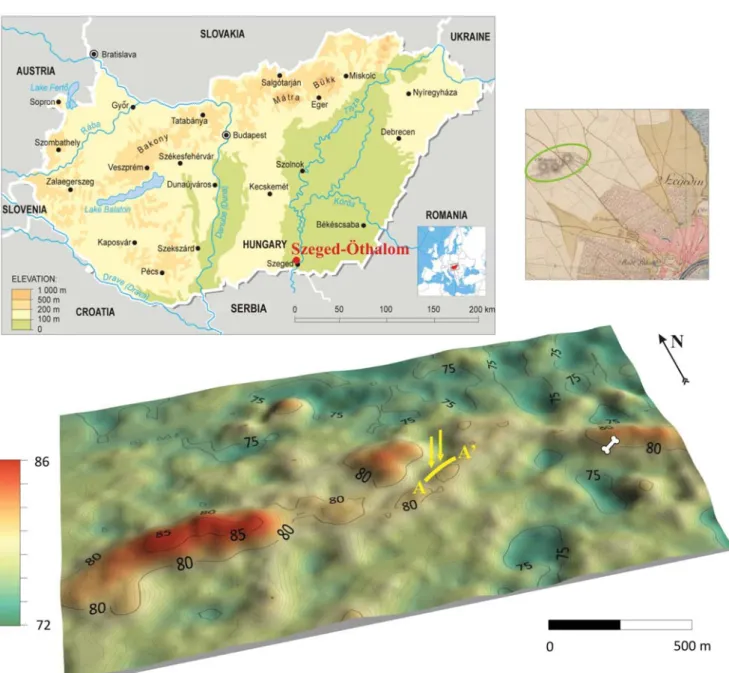
Due to flood prevention measures the average height of the mounds was reduced, and many mounds were totally removed from the original locations in the need of building dams (Krolopp et al., 1995; Lechner, 2000). Archaeological excavations also made great differences to the original con- dition of this site. However, it was the stationed army that did most damage between 1950 and 1990, because barracks were constructed next to the examined area, and the territory comprising the mounds was used as a training field. Even a sandpit was formed next to one of these mounds, which was the initial point for the recurring research since 1990 (coor- dinates of the sandpit: N 46°17’14.29”; E 20°06’10.66”).
Nowadays there are only three bigger and one residual mounds left (Fig. 1). Their detailed lithological analysis and the definition of their extensional position were based on
24 shallow corings and two 6-m high outcrops inside the pit (Szöőr et al., 1992; Krolopp et al., 1995; Sümegi et al., 2015; Fig. 2). The outcrops have different lithologies, ow- ing to diverse accumulation environments. The topography here is undoubtedly determined by distribution of a wind- blown sand. A top of this sand layer became soil-like and can be traced all over the surface of the mounds. However, it is replaced by lake sediments at lower level. A loess that conserves a shape of the sand-mounds can be found in two forms. Between the sand-mounds, marshes (so-called semlyék in Hungarian) have evolved, with mostly infusion loess in them, while a typical loess is more common at the higher levels of the sand-mounds. This type is accumulated mainly on top of the mounds, and occurs only in island-like features. Contrary, the infusion loess is much more exten-
Fig. 1. Location of Szeged-Öthalom on the map of 1st Austrian Military Survey (1763–1787) and the recent topography on 3D DTM (yellow line:
A-A’ section, yellow arrows: the investigated profiles; bone: location of the mammoth hip found in 1935).
REVISITING THE PALEOLITHIC SITE AT SZEGED-ÖTHALOM
47
sive. A top part of the loess had become soil-like trans- formed, however, its evidences can be found at undisturbed places only (Krolopp et al., 1995; Sümegi et al., 2015).
MATERIAL AND METHODS
Nine radiocarbon age analyses were done in the ex- amined profiles, mostly from mollusc shells, but one time from a charcoal. In the first segment (Profile #1 (aeolian)) five measurements were performed, while in the second one (Profile #2 (infusion)) four were carried out. Moreover, in 1935 a Mammoth pelvic-bone piece was excavated, how- ever its stratigraphy is uncertain, because the piece was found east from the examined profiles (Fig. 1). According to the specification it was laid bare from 4.5 m deep from quondam surface (Banner, 1936), that presumes about 84–86 m a.s.l. Regardless of this, based on the calibrated age of the bone, a correlation is possible. The raw age data were calibrated according to the IntCal13.14c calibration curve (Reimer et al., 2014) with help of the Calib 7.0.4 software (Stuvier and Reimer, 1993) and Bacon (Blaauw and Christen, 2011). Bayesian age-depth models were con- structed for both segments from the disposable age data with the help of the Bacon software. Bayesian modelling was performed using Gamma- and Poisson distributions as prior information on accumulation rates. Bacon (Blaauw
and Christen, 2011) models the accumulation rates of many equally spaced depth sections based on an autoregressive process with specified distributions. ARs (accumulation rates) were estimated at 42–48 mln Markov Chain Monte Carlo (MCMC) iterations, and the rates form the age-depth models. AR was first constraint by default prior informa- tion: acc. shape = 1.5 and acc. mean = 50 for the gamma distribution, a memory mean = 0.7 and memory strength = 4 for beta distribution describing the autocorrelation of AR.
Age modelling was run to achieve a 4 cm final resolution initially. The fit of posterior gamma and beta distributions, as well as the 95% CI (confidence interval) ranges, plus the AR with 95% CI ranges were considered in order to choose the best model. Finally, age-depth modelling was run using the parameters set for the best chosen model to obtain a 1-cm resolution age-depth model. Sedimentation rates (mm/year) were calculated using the best age-depth model using equation:
AR = (d2-d1)/(a2-a1) × 1000 (1)
where d1 and d2 are consecutive depths at 1-cm intervals, a1 and a2 are mean model ages. 95% confidence ranges were also calculated using the same equation but a1 and a2 here represents lower and upper 95% CI. The model- based AR was used to express both the average overall temporal resolution and its fluctuations along the entire time-span of the profile.
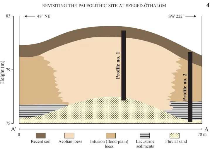
Fig. 2. Schematic drawing of the A-A’ section with the locations of the investigated profiles.
48° NE SW 222°
75 79 83
Height(m)
0 70 m
A’ A
Pr ofile no. 1 Pr ofile no. 2
Aeolian loess Infusion (flood-plain) loess
Recent soil Lacustrine
sediments
Fluvial sand
RESULTS AND DISCUSSION
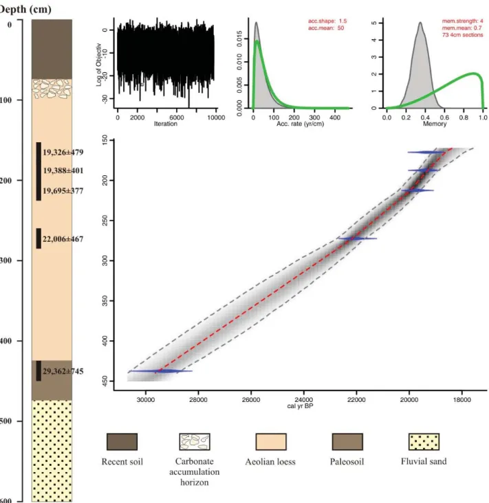
When establishing the age-depth models for both ex- amined profiles, only smaller parts of these were studied here because when sampling was done, no one thought about generating a model that considers the whole profile individually. However, the examined parts are from similar time intervals. The section between 150 and 450 cm of the Profile #1 was formed between ~19,326 and ~29,362 cal BP (Fig. 3; Table 1), that means 300 cm sediment over ~10 ka.
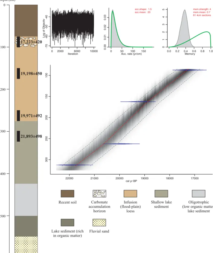
In this case, the average AR is ~0.3 mm/year. On the other hand, in the case of the Profile 2, the section 75–325 cm
was formed between ~17,223 and ~21,893 cal BP (Fig. 4;
Table 1). It means that the 250-cm thick sediment has been deposited over ~4670 years. The average accumulation rate here is 0.535 mm a-1 and about 1.8 times higher than what we found in the aeolian profile. Both age-depth model CI allow a relatively large deviation from the mean, just like the available radiocarbon data (Figs. 3, 4; Table 1). This is because when these samplings were done, AMS radio- carbon calculations were not so common yet, bulk-type calculations were used instead, which clearly gave high dispersion data (Gillespie et al., 1986; Bronk Ramsey et al., 2004).
Fig. 3. Lithology of the aeolian loess (Profile #1) profile and the constructed age-depth model.
REVISITING THE PALEOLITHIC SITE AT SZEGED-ÖTHALOM
49
The profiles are only 30 m apart from each other, but because of different accumulation environments, their li- thology structure is completely different. Their bedrock, composed of wind-blown sand, is at the same level. In both cases, aeolian dust has been deposited on sand in two
depositional environments. Typical loess can be found on diversified reliefs, and lacustrine sediment and infusion loess in deeper areas. According to our age data, the dust accumulation started 30.000 years ago.
Based on the cm-based resolution age model, the com-
Fig. 4. Lithology of the infusion loess (Profile #2) profile and the constructed age-depth model.
0
100
200
300
400
500
600
17,223±420
19,198±450
19,971±492
21,893±498
Depth (cm)
Recent soil Infusion
(flood-plain) loess Carbonate
accumulation horizon
Shallow lake sediment
Fluvial sand
Oligotrophic (low organic matter)
lake sediment
Lake sediment (rich in organic matter)
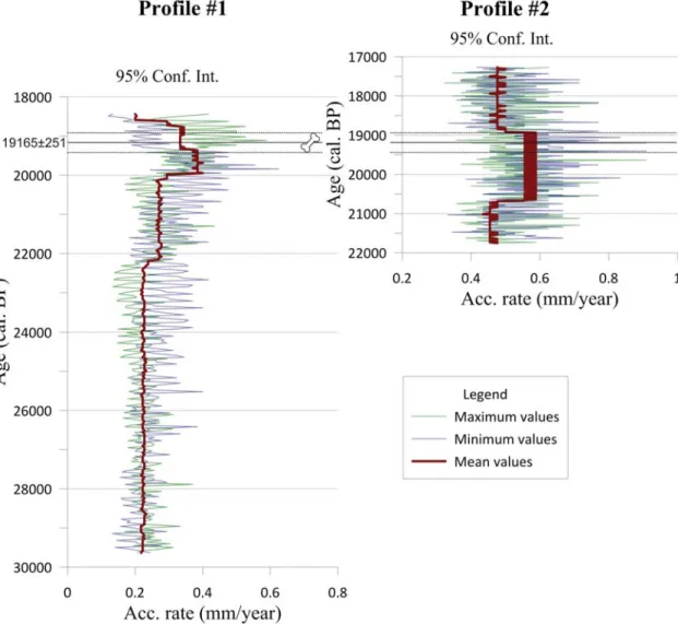
bination of the AR graphs were calculated with 95% of the CI, and were constructed for the same time interval since the timing of the profiles are similar (Fig. 5). As stated in the graph of the Profile #1, the AR is quite low within the older parts of the profile, showing a value below average (0.21–0.25 mm a-2), which had been going on until about 22,100 cal BP. There is a small rise then, reaching near the average rate, but still not quite (0.25–0.27 mm a-2). This pro- cess had been going on approximately until 20,000 cal BP.
The most significant dust accumulation took place between 19,300 and 20,000 cal BP and AR reached even 0.38 mm a-2. Within the CI, this rates could be even 0.5–0.6 mm a-2. After the accumulation apex a slight decrease occurred between 19,300 and 18,700 cal BP (0.30–0.33 mm a-2), after this point the sediment accumulation slowed down a lot, in the latest horizon these values go up only until 0.20 mm a-2. On the other hand, in the case of the Profile #2, compared to the 0.535 mm a-2 average rate, in the older horizon between 21,700 and 20,700 cal BP yr, 0.45–0.47 mm a-2 AR values were calculated (Fig. 5). In this profile the highest ARs are between 20,700 and 18,900 cal BP yr, equal to 0.55–
0.58 mm a-2, although they do not differ too much from the average rate, not like the maximum of the AR in the Profile
#1. Within the CI, the values reach even 0.7–0.9 mm a-2. After the dust accumulation peak, intensity of accumulation decreased, and the SR values in the most recent parts of the profile are below the average, equal to 0.47–0.50 mm a-2. The shape of the graphs are similar, in both cases lower than the average accumulation values in the older part of the seg- ments, and then around 20,000 cal BP there is the AR max- imum in both segments. After the peak, there the values are below the average. In the Profile #2 the AR values exceeded the ones from the Profile 1, but when comparing the average values no significant differences occur. All in all, while the dust accumulation intensity of the aeolian environment showed remarkable amplitudes, meanwhile the dust accu- mulation was more intensive in the subaquatic environment but still steady as well.
The available number and the type (bulk) of radiocar- bon samples are not the best for calculation of the age- depth models, because AMS types are much more accurate.
Nevertheless, these data were suitable for creating the age- depth models. The chosen algorithm (Bayesian) resulted smooth running models with nearly steady AR values.
Unfortunately, Bacon algorithm avoids sudden changes in the sedimentation rate, which could be eliminated by hav- ing more radiocarbon samples from each profile or creat- ing other, linear or polynomial types of age-depth models (Stevens et al., 2011; Perić et al., in press). The best option to choose was to find an algorithm, which could calculate a reliable age-depth model and even reliable AR values in such profiles with only a few radiocarbon data avail- able. This is why the Bayesian calculation was chosen, as it represents a nearly linear graph with relatively narrow confidence intervals for both profiles (Figs. 3 and 4), and the model-based AR values (Fig. 5) are suitable for several conclusions, including determination of the late LGM dust flux maximum. Naturally, it would be much better if there were more radiocarbon data available from each profile, because approximately a single 14C age per 1 m would be adequate and could result in a more reasonable model and accumulation rates.
CONCLUSIONS
Accumulation rates of two examined profiles introduc- ing subaerial and subaquatic environment by the Szeged- Öthalom area indicate similar trends. It is manifested mostly in intensive dust accumulation between 20,500 and 19,000 cal BP (Fig. 5). This period chronologically ranges with the reconstructed accumulation-maximum of the Madaras loess-palaeosol sequence segment (Sümegi et al., in press), which corresponds to the last and coldest period of the LGM (Clark et al., 2009). This conjectures that the ice sheet was located nearest to the studied locali- ties (Hemming, 2004). The AR graphs of the two profiles are very similar, but there is a significant difference in the mean AR values. Compared to the Profile #1, the AR values are higher in the Profile #2. The reason for this is presumably a local topography, the subaquatic accumula- tion environment had been formed at lower places, while Table 1. Uncalibrated and calibrated (BP and BC) radiocarbon data from Szeged-Öthalom and the mentioned sites.
Profile Depth (cm) Uncal age (ys) Cal BP age (ys) Cal BC age (ys) Material Code
Profile #1 150–175 16000±200 19326±479 17377±479 Shell Deb-2056
Profile #1 175–200 16080±150 19388±401 17438±401 Shell Deb-1486
Profile #1 200–225 16323±145 19695±377 17746±377 Shell Deb-3159
Profile #1 250–275 18205±206 22006±467 20057±467 Shell Deb-3184
Profile #1 425–450 25200±300 29362±745 27413±745 Wood Deb-2049
Profile #2 75–100 14179±140 17223±420 15274±420 Shell Deb-2057
Profile #2 150–175 15890±200 19198±450 17249±450 Shell Deb-2054
Profile #2 250–275 16530±200 19971±492 18022±492 Shell Deb-1600
Profile #2 300–325 18080±200 21893±498 19944±498 Shell Deb-3183
Mammoth bone from 1935 15890±100 19165±251 17215±250 Bone Deb-3344
Madaras (Dobosi, 1967) 18080±405 21793±976 19843±976 Charcoal unknown
Ságvár 1 (Krolopp and Sümegi, 2002) 17600±150 21292±439 19343±439 unknown unknown
Ságvár 2 (Krolopp and Sümegi, 2002) 18900±100 22758±268 20809±268 unknown unknown
REVISITING THE PALEOLITHIC SITE AT SZEGED-ÖTHALOM
51
subaerial ones at higher places (Fig. 2). The lower reliefs, like the intermound shallows are relatively more leeward than the mounds; this means, because of their position that they are more suitable for dust accumulation (Pye, 1995).
Furthermore, these intermound shallows were underwater what favoured intensive deposition. Presumably, these two factors caused the higher AR value in the Profile #2.
The excavated mammal bone and Palaeolithic imple- ments, found in 1935, were located 300 m to the east from the carved profiles (Banner, 1936; Fig. 1). According to the original description, the bone and the tools (blade, chisel, etc.; Banner 1936) were found in loess, ergo from the easternmost dry mound relief. The age of the bone was 19,165±251 cal BP (17,215±251 cal BC). Based on this, presence of the Palaeolithic hunters must have been by the end of the LGM, to be more precise at GS-2.1b Stadial (Bond et al., 1993; Björck et al., 1998; EPICA Members, 2006; Clark et al., 2009; Rasmussen et al., 2014; Fig. 5).
According to the former palaeoecological tests, surpris- ingly forest steppe vegetation was common at that time with approximately 16–17°C mean temperature in July (Sümegi
and Krolopp, 2000; Sümegi et al., 2015). Based on the malacological research, the forest density was around 80%
and typical forest-dweller species (Vestia turgida, Clausilia dubia, Discus ruderatus, Mastus venerabilis. Punctum pygmaeum) turned up (Sümegi et al., 2015). As opposed to the global climate, the climate in the studied area was not dry-cold, but a moderately wet climate with extended forest cover was typical. This phenomenon though is not unique at that time: in the Southern Carpathian Basin there were strong continental and sub-Mediterranean climatic influ- ences, resulting in milder climate and forestation. However, inner regions of the Carpathian Basin were drier and colder (Sümegi and Krolopp, 2000; Sümegi et al., 2011, 2015).
Because of the relatively mild climate and raised posi- tion, it served as an ideal campsite for the Palaeolithic hunt- ers during the second wave of settlement in the Gravettian period (Dobosi, 2003). From the top of the mounds, there must have been a great lookout over the flood basin of the Tisa River, that provided handicap for hunting. The age of the Öthalom site is younger compared to the other ones from the second wave. The archaeological site near
Fig. 5. Comparison of the calculated AR of both profiles and defining the place of the Palaeolithic findings in geological time (bone symbol); AR values are derived from Bacon models.
Madaras is ~70 km to the west and it is 21,793±976 cal BP years old (Dobosi, 1967; Table 1). The age of the most famous one near Ságvár (Lengyel, 2010; Bösken et al., 2018) is dated between 21,292±439 and 22,758±268 cal BP (Krolopp and Sümegi, 2002; Table 1). Therefore, among the Gravettian sites in the southern regions of the Carpathian Basin, the one at Öthalom was the youngest. It may involve traces of a specific hunter group or it might have served as a seasonal place for where the hunters coming by. There are still some ‘white spots’ in our research, among them a search for the most suitable algorithm is needed to calculate more precise age-depth models and to obtain more specific data. To reach this, several (at least 5 for each profile) new AMS radiocarbon ages are needed.
Acknowledgments
This research was supported by the Hungarian Human Resource Development Operational Program under project code: EFOP-3.6.1- 16-2016-00008 and Ministry of Human Capacities, Hungary grant 20391-3/2018/FEKUSTRAT.
REFERENCES
Bálint, Cs., 1968. Honfoglalás kori sírok Szeged-Öthalmon. MFMÉ 1968, 47–89. (in Hungarian)
Banner, J., 1936. Az első alföldi palaeolit-lelet. (Der erste Paläo- lith-fund in der ungarischen Tiefebene) – Dolgozatok a Magyar Királyi Ferencz József Tudományegyetem Archeológiai In- tézetéből 12, 1–13. (in Hungarian and German).
Bösken, J., Sümegi P., Zeeden, C., Klasen, N., Gulyás S., Lehmkuhl, F., 2018. Investigating the last glacial Gravettian site ‘Ságvár Ly- ukas Hill’ (Hungary) and its palaeoenvironmental and geochrono- logical context using a multi-proxy approach. Palaeogeography, Palaeoclimatology, Palaeoecology 509, 77–90.
Björck, S., Walker, M.J.C., Cwynar, L.C., Johnsen, S., Knudsen, K.L., Lowe, J.J., Wohlfarth, B., and intimate members., 1998. An event stratigraphy for the Last Termination in the North Atlantic region based on the Greenland ice-core record: A proposal by the INTI- MATE group. Journal of Quaternary Science 13, 283–292.
Blaauw, M., Christen, J.A., 2011. Flexible palaeoclimate age-depth models using an autoregressive gamma process. Bayesian Anal- ysis 3, 457–474.
Bond, G.C., Broecker, W.S., Johnsen S., McManus, J.F., Labeyrie, L., Jouzel, J., Bonani, G., 1993. Correlation between climate records from North Atlantic sediments and Greenland ice. Nature 365, 143–147.
Bronk Ramsey, C., Higham, T., Leach, P., 2004. Towards high-pre- cision AMS: progress and limitations. Radiocarbon 46/1, 17–24.
Clark, P.U., Dyke, A.S., Shakun, J.D., Carlson, A.E., Clark, J., Wohl- fahrt, B., Mitrovica, J.X., Hostetler, S.W., McCabe M., 2009. The Last Glacial Maximum. Science 325, 710–714.
Dobosi, T.V., 1967. Új felsőpalaeolit telep az Alföldön. Archeológiai Értesítő 94, 184–193. (in Hungarian with English summary) Dobosi, T.V., 2003. A jégkorszak végének vadászai. In: Visy, Zs. (Ed.),
Magyar régészet az ezredfordulón. NKÖM Műemléki Főosztály, Budapest, 85–91. (in Hungarian)
EPICA Community Members., 2006. One-to-one coupling of glacial cli- mate variability in Greenland and Antarctica. Nature, 444, 195–198.
Gillespie, R., Hedges, R.E.M., Humm, M.J., 1986. Routine AMS dat- ing of bone and shell proteins. Radiocarbon 28/2A, 451–456.
Hemming, S.R., 20004. Heinrich events: massive Late Pleistocene de- tritus layers of the North Atlantic and their global climate inprint.
Review of Geophysics 42, RG1005, 1–43.
Jakucs, L., 1979. A szegedi I. Téglagyár agyagbányájának összefoglaló földtani jelentése. Békéscsaba, 1–114. (in Hungarian).
Krolopp, E., Sümegi, P., 2002. A ságvári lösz-rétegsor csigafaunája.
Malakológiai tájékoztató 20, 7–14. (in Hungarian with English abstract)
Krolopp, E., Sümegi, P., Kuti, L., Hertelendi, E., Kordos, L., 1995.
Szeged-Öthalom környéki löszképződmények keletkezésének palaeoökológiai rekonstrukciója. Földtani Közlöny 125/3–4, 309–
361. (in Hungarian).
Lechner, L., 2000. Szeged újjáépítése (reprint). p. 139. (in Hungarian) Lengyel, Gy., 2010. An aspect to re-evaluation of Ságvár (Lyu- kas-domb) Upper Palaeolithic site. Folia Archeologica, 54, 25–37.
Mezősi, G., 1983. Szeged geomorfológiai vázlata. (Geomorphological sketch of Szeged) – Alföldi tanulmányok 7, 59–74. (in Hungarian with English summary).
Miháltz, I., 1953. A Duna – Tisza köze déli részének földtani felvétele.
(Le levé géologique de la partie méridionale de’Entre-deux- fleuves Danube – Tisza) – MÁFI Évi jelentése 1950-ről, 113–143.
(in Hungarian with French summary).
Miháltz, I., 1967. A Dél-Alföld felszínközeli rétegeinek földtana. (Ge- ologie der oberflachenneher Schichten des südlichen Teiles der Grossen Ungarischen Tiefebene) – Földtani Közlöny 97, 294–307.
(in Hungarian with German summary).
Paluch, T., 2010. Honfoglaló sírok Szeged-Öthalmon – Négy korszak emlékanyaga. Múzeum Café, 4/15, 38–39. (in Hungarian) Paluch, T., 2016. Újabb preszkíta sírok Szeged-Öthalmon. Újabb
adatok a Kárpát-medence kora-vaskori temetkezési szokásaihoz.
MFMÉ 2016, 3, 11–23. (in Hugarian with English summary) Párducz, M., 1960. Hunkori szarmata temető Szeged-Öthalmon.
Sarmatischer Friedhof aus der Hunnenzeit in Szeged-Öthalom.
MFMÉ 1958–1959, 71–99. (in Hungarian)
Perić, Z., Lagerbäck Adolphi, E., Stevens, T., Újvári G., Zeeden, C., Buylaert, J.P., Marković, S.B., Hambach, U., Fischer, P., Schmidt, C., Schulte, P., Huyau, L., Shuangwen, Y., Lehmkuhl, F., Obreht, I., Veres, D., Thiel, C., Frechen, M., Jain, M., Vött, A., Zöller, L., Gavrilov. M.B., in press. Quartz OSL dating of later quaternary Chinese and Serbian loess: A cross Eurasian comparison of dust mass accumulation rates. Quaternary International, in press Pécsi, M., Schweitzer, F., 1991. Short- and long-term terrestrial re-
cords of the Middle Danubian Basin. In: Pécsi, M., Schweitzer, F. (Eds): Quaternary Environment in Hungary, Akadémiai Kiadó, Budapest, 9–27.
Pye, K., 1995. The nature, origin and accumulation of loess, Quaterna- ry Science Reviews, 14, 653–667.
Rasmussen, S.O., Bigler, M., Blockley, S.P., Blunier, T., Buchardt, S.L., Clausen, H.B., Gkinis, V., 2014. A stratigraphic framework for abrupt climatic changes during the Last Glacial period based on three synchronized Greenland ice-core records: refining and extending the INTIMATE event stratigraphy. Quaternary Science Reviews 106, 14–28.
Reimer, P.J., Bard, E., Bayliss, A., Beck, J.W., Blackwell, P.G., Bronk-Ramsey, C., Buck, C.E., Cheng, H., Edwards, R.L., Fried- rich, M., Grootes, P.M., Guilderson, T.P., Haflidason, H., Hajdas, I., Hatt_e, C., Heaton, T.J., Hogg, A.G., Hughen, K.A., Kaiser, K.F., Kromer, B., Manning, S.W., Niu, M., Reimer, R.W., Rich- ards, D.A., Scott, E.M., Southon, J.R., Turney, C.S.M., van der Plicht, J., 2014. IntCal13 and MARINE13 radiocarbon age cali- bration curves 0-50000 years cal BP. Radiocarbon 55, 1869–1887.
Reizner, J., 1904. Lebői, öthalmi és Ó-bébai ásatások. Archeológiai Értesítő, 24, 76–88. (in Hungarian)
Rónai, A., 1979. Az Alföld földtani atlasza – Szeged. MÁFI, Budapest (I–XI. 1–19.). (in Hungarian).
REVISITING THE PALEOLITHIC SITE AT SZEGED-ÖTHALOM
53
Rotarides, M., 1931. A lösz csigafaunája, összevetve a mai faunával, különös tekintettel a szegedvidéki löszökre. (Die Schneckenfauna des ungarischen Losses und die ungarische rzente Schneckenfau- na, mit besonderer Berücksichtigung der Lösse von Szeged) – A Szegedi Alföldkutató Bizottság Könyvtára, 6. A. 8, 1–180. (in Hungarian with German summary).
Stevens, T., Marković, S.B., Zech, M., Hambach, U., Sümegi P., 2011.
Dust deposition and climate in the Carpathian Basin over an inde- pendently dated last glacial-interglacial cycle. Quaternary Science Reviews, 30 (5–6), 662–681.
Stuiver, M., Reimer, P.J., 1993. Extended 14C data base and revised CALIB 3.0 14C Age calibration program, Radiocarbon, 35/1, 215–230.
Sümegi, P., 2005. Loess and Upper Palaeolithic environment in Hun- gary, Aurea Kiadó, Nagykovácsi, p. 312
Sümegi, P., Krolopp, E., 2000. Palaeoecological reconstruction of the Ságvár-Lascaux interstadial (Upper Weichselian). A la recherche de l’Homme préhistorique. ERAUL 95 Liege. 103–111.
Sümegi, P., Molnár, M., Jakab, G., Persaits, G., Majkut, P., Páll, D.G., Gulyás, S., Jull, A.J.T., Törőcsik, T., 2011. Radiocarbon- dated pa- laeoenvironmental changes on a lake and peat sediment sequence from the central part of the Great Hungarian Plains (Central Eu- rope) during the last 25.000 years. Radiocarbon 52, 85–97.
Sümegi, P., Náfrádi, K., Molnár, D., Sávai, Sz., 2015. Results of pa- laeoecological studies in the loess region of Szeged-Öthalom (SE Hungary), Quaternary International, 357, 1–13.
Sümegi, P., Gulyás, S., Molnár, D., Szilágyi, G., Sümegi, B.P., Törőc- sik, T., Molnár, M., in press. A high-resolution 14C dated chronol- ogy of the thickest and best resolved loess/palaeosol record of the LGM from SE Hungary. Radiocarbon,
Szalontai, Cs., 2016. A Szeged-öthalmi avar- és honfoglalás kori lelőhelyekről. In: Csécs T., Takács M. (Eds), Beatus homo qui in- venit sapientiam. Palatia Nyomda és Kiadó, Győr, 2016. 687–699.
(in Hungarian)
Szónoky, M., 1963. A szegedi téglagyári lösz-szelvény finomrétegtani felbontása. (Feinstratigraphische Gliederung des Lössprofils in der Ziegelei von Szeged) – Földtani Közlöny, 93, 235–243. (in Hungarian with German summary).
Szöőr, Gy., Sümegi, P., Félegyházi, E., 1992. Szeged környéki sekély- mélységű fúrások anyagának üledékföldtani, őslénytani vizs- gálata, fáciestani és palaeoökológiai értékelése. In: Szöőr, Gy.
(Ed.), Fáciesanalitikai, palaeobiogeokémiai és palaeoökológiai kutatások. MTA Debreceni Akadémiai Bizottság, Debrecen, 193–
203. (in Hungarian).
Varázséji, G., 1880. A szeged-öthalmi őstelep és temető. Archeológiai Értesítő, 14, 323–336. (in Hungarian)