QU AT ER NA RY E NV IR ON M EN T IN H UN GA RY
QUATERNARY ENVIRONMENT
IN HUNGARY
AKADÉMIAI KIADÓ - BUDAPEST
QUATERNARY ENVIRONMENT IN HUNGARY
(Studies in Geography in Hungary 26) Edited by
M ÁRTON PÉCSI and FERENC SCHWEITZER
In past decades a detailed subdivision of the Quaternary was carried out with special em
phasis on climatic or environmental phases with the Last Glacial cycle of the Pleistocene.
Most recently studies on global and regional scale of the Late Quaternary ecological chan
ges have come to the fore.
This collection of papers gives an overview of the long- and short-term terrestrial records of the Middle Danube Basin (Hungary), of pa- leogeographical, environmental or climatic changes since the Last Interglacial, of the cycles of solar climatic types since the Riss Glacial, of the Upper Pleistocene events and of the vegetation history of the Great Hun
garian Plain. Relying on complex sedimen- tological and radiometric investigations the Holocene evolution of the Lake Balaton is described, radiometric data are given on the Holocene deposition o f the Danube, a min- eralogical study for dating the thin tephra layer in Hungarian loess profiles is presented, as well as mass movements on steep loess slopes occurring on agricultural land are an
alysed.
The contributors of the volume meant to pro
vide information on the recent results of their investigations for the participants of the XHIth Congress of the International Union of Quaternary Research in Beijing.
STUDIES IN GEOGRAPHY IN HUNGARY, 26
Geographical Research Institute
Hungarian Academy of Sciences, Budapest
Editor-in-Chief:
M. PÉCSI
Editorial Board:
D. LÓCZY L. VARGA
QUATERNARY ENVIRONMENT IN HUNGARY
QUATERNARY ENVIRONMENT IN HUNGARY
Contribution of the Hungarian National Committee to the XNIth INQUA Congress
Beijing, China, August 1991
Edited by
MÁRTON PÉCSI FERENC SCHWEITZER Geographical Research Institute
Hungarian Academy of Sciences, Budapest
AKADÉMIAI KIADÓ, BUDAPEST 1991
Technical editor:
L. VARGA
Translated by D. LÓCZY
Revised by M. PÉCSI
Technical board:
K. JÁNOSSY, ZS. KERESZTESI, J. NÉMETH, I. POOR, B. PORTÖRŐ, E. TARPAY, L. VARGA
ISBN 963 05 6080 1 HU-ISSN 0081-7961
© Akadémiai Kiadó, Budapest 1991
© English translation — D. Lóczy
All rights reserved. N o part of this book may be reproduced by any means, or transmitted, or translated into machine language without the written permission o f the publisher
Printed in Hungary, in the Geographical Research Institute Hungarian Academy o f Sciences, Budapest
CONTENTS
PREFACE (PÉCSI, M„ SCHWEITZER, F.) ... 7 PÉCSI, M. — SCHWEITZER, R: Short- and long-term terrestrial records of the
Middle Danubian Basin ... 9 BARISS, N.: The changing paleogeographic environment during the Upper
Pleistocene at Northern Mid latitudes ... 27 JÁRAI-KOMLÓDI, M.: Late Pleistocene vegetation history in Hungary since
the Last Interglacial ... 35 SZÖŐR, Gy. — SÜMEGI, P. — BALÁZS, É.: Sedimentological and geochemical
analysis of Upper Pleistocene paleosols of the Hajdúság region, NE Hungary . 47 SZÖŐR, Gy. — SÜMEGI, P. — HERTELENDI, E.: Malacological and isotope geo
chemical methods for tracing Upper Quaternary climatic changes ... 61 CSERNY, T. — NAGY-BODOR, E. — HAJÓS, M.: Contributions to the sedi-
mentology and evolution history of Lake Balaton ... 75 HERTELENDI, E. — PETZ, R. — SCHEUER, Gy. — SCHWEITZER, F : Radio
carbon age of the formation in the Paks-Szekszárd depression ... 85 GÁBRIS, Gy. — HORVÁTH, E. — JUVIGNÉ, E.: Pleistocene marker horizon in
Carpathian Basin loess: the Bag Tephra ... 91 PINCZÉS, Z.: Winter, late-winter erosion processes and features in a loess region 99
PR E FA C E
Over the past two decades the Hungarian National Committee of INQUA has been regularly publishing collections of papers on Quaternary research for the INQUA Congresses. For the most recent Xllth Congress (Ottawa, Canada) two separate volumes on Holocene and Pleistocene environmental changes in Hungary were issued. For the XHIth Congress in Beijing papers providing information on part of our recent results a collection entitled ’Quaternary environment in Hungary’ is meant to appear.
In past decades attempts have been made at detailed subdivision of the Quaternary with special emphasis on the duration of climatic or environmental phases within the Last Glacial cycle of the Pleistocene. Most recently, the investigations of global and regional scale Late Quaternary ecological changes have come to the fore in INQUA research projects.
In this collection of papers mostly studies related to these topics appear. As an introductory paper a comprehensive overview is given of the long- and short-term terrestrial records of the Middle Danube Basin (Hungary) on the basis of analyses of subaerial profiles and deep cores. Part of the analysed profiles embrace the whole Quaternary while others even date back to the Neogene (Pécsi, M. and Schweitzer, F.).
Most of the papers deal with paleogeographic, environmental or climatic changes since the Last Interglacial. N. Bariss reinterprets the cycles of solar climatic types since the Riss Glacial, based on data by Milankovitch and Bacsák. As mirrored by palynological studies, the Upper Pleistocene vegetation history for the Great Hungarian Plain is summarised by M. Járai-Komlódi. In another paper Upper Pleistocene climatic changes are described using malaco-thermometric and geochemical methods (Szöőr, Gy., Sümegi, P. and Hertelendi, E.). Also on the basis of sedimentological and geochemical analyses of young loess-paleosol sequences buried meadow and alkali soils are dated (Szöőr, Gy., Sümegi, P. and Balázs, E.). The 12, 000 years of Holocene evolution of Lake Balaton is described in more detail relying on complex sedimentological and radiometric investi
gations (Csemy, T., Nagy-Bodor, E. and Hajós, M.). Radiometric data are given on the Holocene deposition of the Danube by E. Hertelendi et al. A comparative mineralogical study for dating the thin tephra layer in Hungarian loess profiles is attempted by a team of Hungarian and Belgian researchers (Gábris, Gy., Horváth, E. and Juvigné, E.). Finally, mass movements on steep loess slopes occurring on agricultural land in winter are analysed (Pinczés, Z.).
The publication of the present volume of studies was supported by the Hungarian National Scientific Research Fund (OTKA).
Acknowledgements are due to all contributors (authors, translators, editors) and to the technical staff who promoted the publication of this volume.
The contributors wish success to the organizers and participants of the XHIth INQUA Congress.
Budapest, June 1991
Márton PÉCSI and Ferenc SCHWEITZER editors
M. Pécsi—F. Schweitzer (eds.) Quaternary environment in Hungary Studies in Geography in Hungary, 26 Akadémiai Kiadó, Budapest 1991, pp. 9—26.
SHORT- AND LONG-TERM TERRESTRIAL RECORDS OF THE MIDDLE DANUBIAN BASIN
M. PÉCSI — F. SCHWEITZER
Geographical Research Institute, ' Hungarian Academy o f Sciences, Andrássy út 62, H-1388 Budapest, Hungary
ABSTRACT
In Central Eastern Europe, in the Middle Danube Basin, loess and loess-like deposits cover various morphotectonic levels in ca. 150,000 km2 total area. Basin types o f various elevation and size are predominant.
Under different geomorphological or morphotectonic conditions — over an identical time interval — the variation in the rate of basin subsidence produces various litho- and chronostratigraphical sequences.
The subaerial sequence of basins affected by prolonged subsidence in the Quaternary is subdivided by paleosols of larger number than the loess-paleosol sequence o f basins, elevated plateaus or watersheds which underwent more moderate subsidence during the Quaternary.
1. Young loess mantles o f small intermountain basins and mountain slopes (at 150-400 m above sea level). In the mantle of slope loess maximum 3 or 4 loess/paleosols and 2 or 3 slope debris layers overlie one another. Their age is < 125,000 years B.P.
2. Low-lying terraces and alluvial fans, flood-plain loess. The thickness o f the loess series o f the subsided alluvial fan is 40-50 m; it is o f Pleistocene age and partly eroded. Flood-plain loesses are 2-5 m thick, occasionally subdivided by one 1 or 2 paleosols. Their age is < 25,000 years B.P.
Loess-paleosol-sand sequences on pediments (100-150 m above sea level). In the loess-paleosol-sand sequences o f 50-100 m thickness ca. 12 loess, 10 sand and silt layers and 20-30 paleosols are present. The age o f these profiles with hiatuses is Pliocene-Pleistocene.
4. Loess-paleosol-sand sequences on alluvial fans and terraces (10-100 m relative heights). The loess sequence is 40-60 m thick and subdivided by 10-12 loess horizons, 10-12 paleosols and 5 or 6 sand layers.
LTR — Pliocene-Pleistocene.
5. Subaerial basin sediment locally of 500-1,500 m thickness. The surface o f the basin is a flood-plain at 90-100 m above sea level. In the basin sediments the number o f paleosols — mostly meadow soils — may reach one hundred. In several boreholes there are 6-12 red soils or red clays between 600 m and 1,000 m. 12-16 intercalated sand layers are observed. The age of this almost complete sequence is 5.2-5.4 million years B.P.
In the m ost intensively subsiding basins sedimentation was almost continuous; during the Pliocene ca.
50-60 and in the Pleistocene ca. 50 soils developed.
In contrast on the non-subsiding foothills only 20-30 soils formed during the Pliocene and Pleistocene and several gaps are detected in the sequence.
INTRODUCTION
Recently, an increasing number of papers have been published on the reconstruc
tion of paleogeographic and climatic changes over the entire Pleistocene or part of the Neogene. In several respects our days are considered the age of ’records’ and thus it is no wonder that Quaternary geochronologists are also seeking to find ’long-term records’
concerning sedimentary rocks. Among other achievements, the successful application of 180 isotope stratigraphy of deep-sea sediments and magnetostratigraphical analyses opened up new vistas in this direction.
Among subaerial deposits the cyclical alternation of loess, loess-like deposits and paleosols also allowed good opportunities to set up ’long-term records’ for the Quaternary (or perhaps extending them into the Neogene) and to make correlations with deep-sea oxygen isotope stages.
Quasi-complete loess-paleosol sequences are kown from the profiles of the Tajik Basin, Central Asia (Dodonov, 1982, 1984, 1987; Lazarenko, 1984; Ranov, 1980), as well as from the Luochuan and Xifeng profiles on the Loess Plateau of China studied by many (Liu, 1985, 1987; Kukla and An, 1989; Liu and Yuan, 1987; Heller et al., 1987;
Sasajima and Wang, 1984).
1. On the margin of the loess-lined Tajik Basin the foothill slopes of 1,500-1,700 m height are dissected into interfluvial ridges. There is much resemblance between profiles, but the loess-paleosol sequences are not totally identical. The most dissected is the 180 m profile at Chasmanigar (Fig. 1, column 21).
In the upper 80 m of the sequence 10 well-developed paleosols are separated by 3-10 m thick loess layers. The Brunhes/Matuyama boundary was found in the loess between the paleosols Nos. IX and X. Below paleosol No. X a very marked erosional hiatus was observed (Dodonov and Penkov, 1977; Lazarenko, 1984). Even below that there is aca. 90 m thick subaerial series with 27 further paleosols indicated by the numbers X to XX. The layers between paleosols — mostly carbonate accumulation horizons — are very much different from true loess. For their compactness and concretion content, they are called locally ’stony loess’. According to Dodonov, the Olduvai paleomagnetic event (1.8 million years B.P.) probably occurs in the upper part of soil complex No. XX.
Below soil complex No. XX red clays and detritic loess-like deposits are found overlying Neogene conglomerate.
Consequently, the Tajik loess-paleosol sequence embraces ca. 2 million years. It has to be noted that this ’stony loess’ series is not true loess.
2. In the various partial basins of the Loess Plateau of China of more than 1,000 m altitude the thickness of loess series and the number of paleosols show great variation (Sasajima and Wang, 1984).
The Xifeng profile differs from the Luochuan one, located 160 km to the east.
Nevertheless, the sequences are generally regarded identical (Fig. 1, column 23). For both type profiles in the major upper part 14 paleosols and 15 loess horizons are identified.
illimi humic cone ..Naßboden
semipedohte IUJU1 loresl steppe soil m lo-esl soil
brown earth B S >ed clay
not identified
®w paleosoi
:: Wucheng loess i i loess in general I i I sandy loess
silty sand
!•! sandy silt slope loess
~ ~ calcium carbonate concretion
*2 tuff gravel
*£h BH MF BO01
abbreviations ot _ localities and
stratotypes
~ ~ change ol age scale
; | “ meadow soil
= = clay, loam
J z Tertiary sediments proliié supplementation (combination)
The B/M paleomagnetic boundary is placed below the paleosol S7 in the Xifeng profile and in loess Ls in the Luochuan profile.
The subaerial sequence cannot easily be subdivided into loess and paleosol layers below sandy loess L15, but clusters of layers with weathering or soil formation of various intensity alternate. This is the so-called Wucheng loess, which includes 4 more pedified clusters of layers (Wsi-Ws4) and 4 clusters of loessy-loamy layers (Wli-Wla) in the Xifeng profile. In the Luochuan profile these divisions are only repeated three times. The paleomagnetic analyses, however, support the interpretation that in both profiles the red clays in the base of the Wucheng series belong to the Gauss epoch. The Olduvai event within the Matuyama epoch (1.67-1.87 million years B.P.) was found in the paleosol group WS2 in the Luochuan profile and in WS3 in the Xifeng profile.
In the above two key sections of the Loess Plateau of China (at Luochuan and Xifeng) 24 and 28 loess horizons and an equal number of paleosols are counted, resp. In a recently analysed profile (at Baoji) the alternation of 32 paleosols and loess horizons have been recorded (Ding et al., 1991).
From the data of paleomagnetic investigations, calculation of sedimentation rate, analysis of magnetic susceptibility curves and comparisons with oxygen isotope stages in deep-sea cores, it was established that by the evidence provided by the profiles of the Loess Plateau of China all the glacial and interglacial periods during the Pleistocene can be identified in the subaerial sequences (Liu, 1987; Liu and Yuan, 1987; Kukla and An,
1989).
The above was described in the introduction as it is doubtful whether on plateaus lying at more than 1,000 m altitude no major sedimentation gap or the removal of some layers have occurred in loose deposits over the past 2.5 million years (Pécsi, 1987). On elevated terrain with drainage network it is difficult to envisage perfect sediment traps, moreover it is known that even in deep-sea sequences hiatuses are common. In addition, the subaerial sequence of the mentioned high-lying basins are confronted with that of the Middle Danube Basin, which is locally thicker than 1,000 m and the base of the sequence lies at more than 1,100 m below sea level.
DISCUSSION
It is undoubtedly the loess-paleosol sequences that provide the best opportunities of all subaerial deposits for the reconstruction of Late Cainozoic paleogeographic-paleo- climatic changes.
The question arises: How many periods suitable for loess formation and how many favouring soil formations occurred during the Quaternary? Our experiences show that the number depended upon climatic patterns in the ’loess superzone’.
Another question which could be put is how many paleosols or loess horizons have
been preserved of all formed in a particular site? It was found that, for instance, in the Middle Danube Basin once various partial basins of different size were superimposed on one another and the rate of subsidence varied in them and resulted in subaerial sequences complete or incomplete to various degrees over identical time intervals.1
1. In the small basins and foothill slopes of uplands (at relative heights of 150-400 m) usually young loess occurs. In the mantle-like slope loess there are maximum 3 or 4 loess and paleosol layers superimposed and on the side closer to mountains 2 or 3 loess horizons with slope debris are also observed.
2. In mountain forelands, over broad basin margins (at 100-150 m relative heights) loess-paleosol-sand sequences of great thickness (50-100 m) occur, occasionally with
10-12 loess, 10 sand and 20-30 paleosol intercalations (Figs. 2-5).
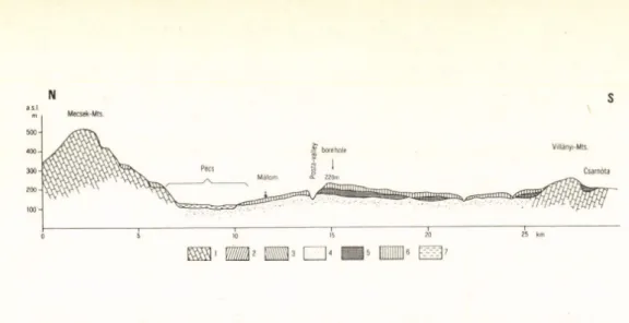
The sequence shown in Figure 3b is on a pediment enclosed by 2 low horsts, overlying Upper Miocene (Pannonian) sand. The sequence has been described in detail in previous publications (Pécsi et al., 1987), here attention is only drawn to some of the
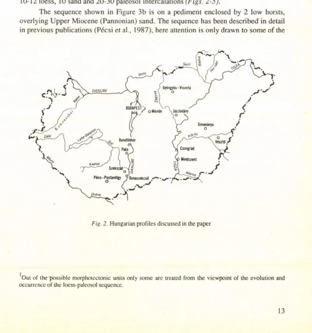
Fig. 2. Hungarian profiles discussed in the paper
'Out o f the possible morphotectonic units only some are treated from the viewpoint of the evolution and occurrence o f the loess-palcosol sequence.
N S
Fig. 3a. Geomorphological and geological situation of Posta valley borehole at Pécs (M. Pécsi and F.
Schweitzer, 1987). 1 = M esozoic limestone, marl, sandstone; 2 = Upper Miocene marine terrace with Sarmatian limestone; Upper M iocene marine terrace (Upper Pannonian); 4 = Upper Miocene (Pannonian) sandy formation; 5 = Pliocene reddish paleosols, red clay formation; 6 = Pleistocene loess and paleosol sequence;
7 = Upper Pleistocene-Holocene alluvial sequence
characteristics. In the ca. 60 m deep profile the upper 7 of the total 29 paleosols are dark coloured steppe soils, paleosols Nos. 7-19 are predominantly forest soils, while Nos.
20-27 and 29 are reddish clayey soils, with several subdividing sandy layers. Older red clay layers can be correlated with the classic red clays in the side of the Villány Mountains, characterized by the Pliocene Csamotian fauna (Kretzoi and Pécsi, 1982). Here the loess-paleosol sequence — with many hiatuses (indicated by dark and light arrows) — represents the Pleistocene period.
In a basically similar morphotectonic position on elevated Upper Miocene (Pan
nonian) strata the loess profiles shown in Figures 4 and 5 are situated.
A characteristic feature of the subaerial sequence of the Gyöngyösvisonta profile (Fig. 6) is that it overlies an eroded pediment of Pannonian lignite-bearing sediments.
Pliocene red clay is only preserved in patches. The subaerial sequence here represents the Pliocene together with the Lower and Middle Pleistocene. The Upper Pleistocene series is very incomplete (Kretzoi et al., 1982; Pécsi, 1985; Pécsi et al., 1985).
3. The loess-paleosol-sand sequences on alluvial fans, alluvial fan terraces (10- 100 m relative height above the flood-plains) are deposited on Upper Miocene (Pannon
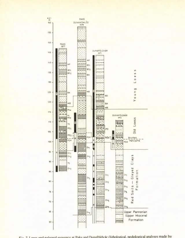
ian) surfaces, basin margins unaffected by subsidence in the Quaternary. Such a (40-60 m thick) loess series outcrops in the bluffs along the Danube at Dunaújváros, Dunaföldvár and Paks and subdivided by 10-14 loess horizons, an equal number of paleosols and 4-6 sand layers (Fig. 7). In this sequence the B/M paleomagnetic boundary was identified below the 8th paleosol (PD2) (Pécsi and Pevzner, 1974; Pécsi, 1987; Márton, 1979). The loess-paleosol sequence here is not older than the Jaramillo event (0.9 million years B.P.).
However, below the 50-60 m loess series ca. 30-40 m thick ’variegated clays’ and sandy silts follow. The lowermost variegated clay and red clay layers of this ’Dunaföldvár
Fig. 3b. Loess-paleosol sequence o f Posta valley at Pécs. (Lithological, paleopedological and mineralogical analyses made by M. Pécsi, Gy. Scheuer, F. Schweitzer, L. Gerei and M. Reményi; paleomagnetical data by P. Márton). R = reverse; N = normal polarity; Li-Lé = young loess; L7-L10 = old loess; S1-S10 = sandy layers;
PiH, P2H = humic loess, embryonal paleosols; P3C-P6C = chernozem-like forest-steppe paleosols; P sB -PuB
= brown forest paleosols; P15R-P29R = ochre-red paleosols, red clays; PnHy, P29Hy = hydromorphic meadow soils; A = clay (2-10 micron); I = fine silt (10-20 micron); L = loess (20-50 micron); H = sand (50-500 micron);
1 = quartz; 2 = felspars; 3 = calcite; 4 = dolomite; 5 = micas + hydromicas; 6 = montmorillonite; 7 = chlorite;
8 = kaolinite; 9 = interstratified minerals; 10 = A1 and Fe hydroxides; 4 = significant unconformity;
=> = unconformity
111 11 1 1
■/////////A a V.V-
F|2
Fig. 4. Loess-paleosol and other subaerial sequen
ces at Dunaszekcsd (after F. Schweitzer and Gy.
Scheuer; legend see Fig. 7)
Formation’ (Pécsi, 1982) belong to the Pliocene (Pécsi, 1985). In its base also Upper Miocene (Pannonian) sediment is found. In our opinion, the ’Dunaföldvár Formation’ can correlate with the ’stony loess’ of Central Asia and the Wucheng Formation of the Chinese Loess Plateau and the underlying red clays (Pécsi, 1987).
Fliatuses are less frequent in the loess- paleosol sequence — with 4-6 intercalated sands — on old alluvial fans over basin mar
gins not affected by subsidence in the Quater
nary than in the mountain foreland profiles.
However, the number of paleosols is similar down to the B/M boundary to the profiles of Central Asia and the Loess Plateau of China.
4. An entirely different subaerial se
quence is recorded in the parts of the basin which underwent gradual subsidence during the Pliocene and the Pleistocene. The thick
ness of basin deposits in the Hungarian Plain locally exceeds 500-1,500 m below the flood- plains of rivers. In the most intensively subsid
ing basins (Fig. 8) red soils and red clays are repeated 6-10 times between 600 and 1,000 m depths. With the preponderant flood-plain, meadow and chernozem soils, the swamp forests also allowed the formation of lignite.
The above two boreholes did not reach the sequence of the Upper Miocene (Pannonian) inland sea to 1,200 m depth. The paleomag- netic study of the cores and paleontological data cover the whole of the Quaternary and extend to most of the Pleistocene (5.25 million years B.P.; Cooke et al., 1979; Rónai, 1977, 1985b). As shown in Figures 9 and 10 in the Pliocene sequence 50-60 and in the Pliocene ca. 50 paleosol horizons are detected. Such a long Late Cainozoic geological record of sub
aerial sediment is only known to date from the exploration boreholes in the Hungarian Plain by Rónai (Rónai, 1985a).
RED SOILS-GIEYED CLAYS FORMATION
SZEKSZÁRD
Fig. 5. Loess-paleosol sequences in the foothill zone at Szekszárd (after F. Schweitzer, Gy. Scheuer and M. Pécsi; legend see Fig. 7)
SSW NNE
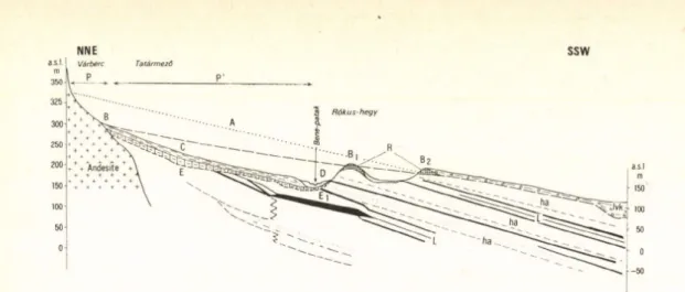
Fig. 6a. Position o f the red clays at the Mátra Foothills (Abasár). A = reconstructed surface o f the Lower Pannonian layers; B, B i, B2 = Pliocene pediment surface; C-D = Upper Pliocene-Lower Pleistocene alluvial fan; E-Ei = strongly eroded Pannonian surface; L = lignite; h = sand; ha = sand, clay; P = pediment;
P’= pediment-glacis; l,v = loess, loam; k = gravel; R = red clay; T = Upper Pleistocene terraces
--- ►
Fig. 6b. Profile o f the open cast lignite mine at the foot o f the Mátra Mountains. (The profile was surveyed and identified by J. Balogh, P. Márton, F. Schweitzer and Gy. Szokolai under the guidance of M. Pécsi, 1982). The correlative sediments for pedimentation are the reddish purple fossil soils (F7 to F15) and clayey rock detritus between fossil soil Fő and sand layer H3. Profile is shown to 60 m, the lower part— 60-95 m — is only included in the description). 0-1.6 m = black meadow soil; 1.6-4.5 m = old loess with remnants of B/BC soil horizon;
4.5-5.2 m = brown forest soil; 5.2-8.1 m = loess-like material, with yellow limy sandy intercalation at the base;
8.1- 8.7 m = yellow limy sand with tuff detritus; 8.7-9.2 m = sand with andesite gravel and with Equus (Allohippus) siissenbornensis; 9.2-9.9 m = flood plain clay soil; 9.9-11.0 m = dark-grey purplish flood plain clay soil; 11.0-12.0 m = CaCCh accumulation horizon; 12.0-13.8 m = grey clay with CaCQt concretions and tuff detritus (Mammuthus irogontherii and Bison sp. finds); 13.8-14.3 m = sand with andesite gravel (Archidiskodon meridionalis find); 14.3-15.3 m = clayey sand with tuff detritus; 15.3-16.7 m = grey clay soil o f flood plain; 16.7-17.7 m = greyish-brown clay with tuff detritus; 18.0-18.8 m = greyish-brown clay with tuff detritus; 18.8-20.4 m = (reddish) brown clay soil; 20.4-21.1 m = limy, sandy old loess; 21.1-23.7 m = clayey sand (from 23.4 sand with tuff detritus); 23.7-25.0 m = purplish aggregated clay (with yellowish-brown sandy tuffeous-detrital wedging); 25.0-25.5 m = yellowish-brownish tuff detritus; 25.5-26.4 m = purple clay soil; 26.4-26.7 m = clayey sand with tuff detritus; 26.7-27.6 m = greyish-purplish clay soil; 27.6-28.0 m = clayey sand with tuff detritus; 28.0-28.9 m = purplish clay with tuff detritus at the base; 28.9-29.1 m = sand with tuff detritus; 29.1-30.4 m = purplish clay (from 29.9 m greyish-purplish clay); 30.4-31.0 m = yellowish- brown coarse sand with tuff detritus; 31.0-31.6 m = purplish clay; 31.6-31.8 m = clay with tuff detritus;
31.8-32.3 m = purple clay with tuff detritus; 32.3-32.7 m = purple clay; 32.7-34.0 m = yellowish-brown sand with tuff detritus; 34.0-35.8 m = sandy clay with yellowish-grey purplish sand of tuff detritus and with Zygolophodon find; 35.8-36.6 m = crumbled clay with yellowish-grey ferrous precipitations o f purplish shade;
36.6- 37.1 m = coarse-grained sand with tuff detritus; 37.1-37.9 m = ferrous sandy clay; 37.9-38.5 m = sandy clay with tuff detritus with purplish tuff detritus at the base; 38.5-41.5 m = micaceous yellow sand with thin sandy mud intercalations; 41.5-42.4 m = greyish-greenish clay; 4 2 4 A 3 .1 m = ochre-yellow clayey sand;
43.1- 45.0 m = grey clay; 45.0-47.0 m = lignite; 47.0-48.3 m = grey clay; 4 8 .3 4 8 .6 m = yellowish-grey sand;
48.6- 50.0 m = grey clay; 50.0-51.8 m = yellowish sandy clay; 51.8-52.7 m = grey clay; 52.7-53.0 m = lignite;
53.0- 55.3 m = grey clay; 55.3-57.2 m = lignite; 57.2-58.0 m = grey clay; 58.0-59.0 m = greyish-yellowish muddy clay being more clayey at the base; 59.0-60.5 m = grey muddy clay; 60.5-61.1 m = lignite; 61.1-62.4 m
= micaceous muddy clay; 62.4-69.5 m = micaceous fine-sandy mud interwoven with grey clay bands, from which water infiltrates; 69.5-75.5 m = grey clay; 75.5-77.2 m = grey fine-sandy mud; 77.2-78.5 m = grey fine-sandy mud; 78.5-79.1 m = muddy yellowish-grey clay; 79.1-82.1 m = micaceous yellow fine sand;
82.1- 84.2 m = grey fine-sandy mud; 84.2-89.6 m = grey micaceous fine sand with clay bands; 89.6-92.5 m = grey micaceous fine-sandy clayey mud being more compact at the base; 92.5-94.5 m = lignite
CT)
o cn
_L_o o OJo rsj
—Oi—
o o
i . . i 11 -i-1. -i—.—i 3
i t t t t t t t
t t t
U n c o n f o r m i t y• c r o s s bedde d s a n d , s i l t a n d l i g n i t e g r o u p i
1 s a n d
______________________________ 1_______
s a n d , l o am , r e d clay g ro u p
s a n d , r e d d i s h p a l e o s o t f o r m a t i o n
f o o t h i l l a l l uv i al f a n , s a n d , clay, p a l e o s o l
old l oess f r a g m e n t s
p a l e o s o l s
C o m p l e x
C h r o n o l o g y
„Upper Pannonian"(= Pontian) Late Miocene
L a t e
P l i 0 c e n e Early Quaternary Middle
Quaternary Late Quatern.
Balta X0»
i
i
M i l l
X ?c<ft,- CL CD
c3
3
i
i t i l l
3O E
Ruscmium — Csarnotanum " 1 3
V i l l a n y i u m
a s . I 160 -i
155 -
150 -
U 5 -
H O -
135 -
130 -
125 -
120 -
115 -
110 -
105 -
100 -
95 -
90 -
85 -
80 -
75 -
70 -
65 -
60 -
P A KS d u n a k ö m lÓd
1978
Fig. 7. Loess and paleosol sequence at Paks and Dunaföldvár (lithological, pedological analyses made by M. Pécsi, E. Szebényi and F. Schweitzer; paleomagnetical measurement m ade by M.A. Pevzner)
In this morphotectonic position, in the deep-subsided basin, the number of paleo- sols (95-115) is about three or locally fourfold exceeds that in the subaerial sequence of the non-subsiding mountain foreland or alluvial fan surfaces.
CONCLUSION
The Plio-Pleistocene terrestrial subaerial sedimentation ensuing on the Upper Miocene (Upper Pannonian) period began with red clay development on slowly subsiding basin surface and then increasing subsidence produced repeated formation of various soils and loose deposits. They are better preserved than in the sequences of the neigh
bouring, non-subsiding basin margins accumulated over the same period.
This approach helps to make our criticism understandable related to the interpre
tation of the sequence on the Loess Plateau of China as complete and full record of climatic changes over the Quaternary.
• I I 1
1 1 1 12
—1---- !---- , 1 , 1 3
H----1---
„ 11 ,, 1Lu 5 • '/ • ' / •
■ 1- - .1. . 1.. ; 1 J___1__ .11___Ü__ / . /
7 m 8 9 ~ ' -- ' —
10
19 oo 20 21 X X X X 2 2 O 0 ° 0 0
O o O 0 0
◄---
legend to Fig. 7.
1 = loessy sand; 2 = sandy loess; 3 = loess; 4 = old loess; 5 = slope sand; 6 = sandy slope loess; 7 = slope loess;
8 = semipedolite; 9 = fluvial-proluvial sand; 10= silty sand; 11 = silt, gleyed silt; 12 = clay; 13 = steppe-type soil, chernozem; 14 = brown forest soil; 15 = red clay; 16 = hydromorphic soil; 17 = alluvial meadow soil; 18
= forest soil(on flood-plain); 19 = calcium carbonate accumulation; 2 0 = loess doll; 2 1 = charcoal; 2 2 = volcanic ash; 23 = sandy gravel; MF = ’’Mende Upper” forest-steppe Soil Complex (Mo. 421 29,800 years B.P., HV 27,855+599 years); BD = ’’Basaharc Double” forest-steppe Soil Complex; BA = ’’Basaharc Lower” chernozem soil; MB = ’’Mende Base” Soil Complex (brown forest soil + forest-steppe soil); Phe = Paks sandy forest soil;
Mtp = Paks marshy soil; PD = ’’Paks Double” Soil Complex (brownish-red Mediterranean-type dry forest soil);
PDK = Paks-Dunakömlőd brownish-red soil; Dvi-Dv6 = red soils (Dunaföldvár-formation);
ih = silty sand; S i-S3 = sand
DE VAVANYA B O R E -H O L E VÉSZTŐ B O R E -H O L E
Fig. 8. Quaternary and Pliocene stratigraphy based on paleomagnetic records in Hungary (A. Rónai, 1985b); (source o f paleomagnetic data: Cooke et al„ 1979)
Fig. 9. Complex geological profile o f the borehole o f Mindszent (plotted by A. Rónai and F. Franyó). I = Paleosols in the profile: Total number o f the Pleistocene series = 46; Total number o f the Pliocene series =
67; for further explanation see Fig. 10
LowermostLowerMiddleUpper
ÜI. IV
Fig. 10. Complex geological profile o f the Csongrád borehole (plotted by A. Rónai and F.
Franyó, A. Rónai 1985a).
I = Paleosols in the profile: Total number o f the Pleistocene series=55; T otal number o f the Pliocene series = 40. II = granulometry: 1 = clay; 2 = fine silt;
3 = coarse silt, sand flour; 4 = fine-grained sand; 5
= middle and coarse-grained sand; 6 = gravel. IH = CaC03 content. IV = Heavy minerals: 1 = hematite, magnetite, ilmenite, leucoxene; 2 = garnet; 3 = dist- hene, staurolite, chloritoide; 4 = epidote, pistacite, piemontite, zoisite, clinozoisite; 5 = tremolite, acti- nolite, anthophyllite, glaucophane, sillimanite; 6 = green amphibolite; 7 = brown amphibole and 1am- probolite; 8 = hypersthene; 9 = augite; 10 = biotite;
II = chlorite; 12 = rutile, brookite, athanase, zircon, titanite, tourmaline, apatite; 13 = limonite, pyrite, siderite, carbonates, clay minerals. V = Ostracoda finds: 1 = Candonaparallela G.W. MÜLLER; 2 = Candona neglecta G.O. SARS; 3 = Candona rost
rata BRADY-NORM; 4 = Candona protzi HART- W IG ; 5 = llyocypris gibba RAM DOHR; 6 = Cyclocypris laevis O.F. MÜLLER; 7 = Cyclocypris huckei TRIEB EL; 8 - Lymnocythere inopinata B A IRD; 9 = Lymnocythere sanctipatricii BRADY-
ROB; 10 = Cytherissa lacustris G.O. SARS
R E FE R E N C E S
Cooke, H.B.S., Hall, J.M. and Rónai, A. ( 1979). Paleomagnetic, sedimentary and climatic records from boreholes at Dévaványa and Vésztő, Hungary. Acta Geologica Acad. Sei. Hung. 22, 1-4, 89-109.
Ding, Z., Liu, T. and Rutter, N. (1991). Pedostraligraphy o f Chinese loess deposits and climatic cycles in the last 2.5 Ma. Catena (in press).
Dodonov, A.E. (1982). Guidebook for excursions A - l l and C - ll. Uzbek SSR, Tajik SSR, INQUA XI.
Congress, Moscow.
Dodonov, A.E. (1984). Stratigraphy and correlation o f Upper Pliocene-Quaternary deposits o f Central Asia.
In: Pécsi, M. (ed.), Lithology and stratigraphy o f loess and paleosols. Budapest. Geogr. Res. Inst. Hung.
Acad, o f Sei., 201-212.
Dodonov, A.E. (1987). Geochronology of loess in Central Asia and Quaternary events. In: Pécsi, M. and Velichko, A. (eds.): Paleogeography and loess (Studies in Geography in Hungary 21). Budapest, Akad.
Kiadó, 65-74.
Dodonov, A.E. and Penkov, A.V. (1977). Nekotorye dannyepo stratigrafii vodorazdel’nykhlessov Tadzikskoy depressii (Yuzhny Tadzhikistan). (Some data on the stratigraphy o f the watershed loesses in Tajik depression). Bull, of the Commission o f the Quaternary Research 4 7 ,6 7 -7 6 .
Franyó, F. (1977). Exploratory drilling on the Great Hungarian Plain by the Hungarian Geological Institute from 1968-1975. Földrajzi Közlemények 25, (101), 60-71.
Franyó, F. (1980). Recent results in studying the geomorphic history and hydrogeology of the Danube - Tisza interfluve based on test boreholes. Földrajzi Értesítő 2 9 ,4,409-445.
Heller, F., Beat, M., Wang, I , Li, H. and Liu, T. (1987). Magnetization and sedimentation history o f loess in Central Loess Plateau o f China. In: Liu, T. (ed.). Aspect o f loess research. Beijing, China Ocean Press, 147-163.
Kretzoi, M. and Pécsi, M. (1982). Pliocene and Quaternary chronostratigraphy and continental surface development of the Pannonian basin. In: Pécsi, M. (ed.). Quaternary studies in Hungary. Budapest, Geogr. Res. Inst. Hung. Acad, o f Sei., 11-42.
Kretzoi, M., Márton, P., Pécsi, M., Schweitzer, F. and Vörös, L. (1982). Pliocene-Pleistocene piedmont correlative sediments in Hungary (based on lithological, geomorphological, paleontological and paleomagnetic analyses o f the exposures in the open-cast mine at Gyöngyösvisonta). In: Pécsi, M.
(ed.). Quaternary studies in Hungary. Budapest, Geogr. Res. Inst. Hung. Acad, of Sei., 43-73.
Kukla, G.J. and An, Z. (1989). Loess stratigraphy in Central China. Palaeogeography, Palaeoclimatology, Palaeoecology 72,203-225.
Lazarenko, A.A. (1984). The loess o f Central Asia. In: Velichko, A.A. (ed.). Late Quaternary environments o f the Soviet Union. Minneapolis, Minnesota University Press, 125-131.
Liu, T. (ed.) (1985). Loess and the environment. Beijing, China Ocean Press.
Liu, T. (ed.) (1987). Aspects o f loess research. Beijing, China Ocean Press.
Liu, T. and Yuan, B. (1987). Paleoclimatic cycles in Northern China (Luochuan loess section and its environmental implication). In: Liu, T. (ed.). Aspects o f loess research. Beijing, China Ocean Press.
Márton, P. (1979). Paleomagnetism o f the Paks brickyard exposures. Acta Geologica Acad. Sei. Hung. 22, 1-4,445-449.
Pécsi, M. (1982). The most typical loess profiles in Hungary. In: Pécsi, M. (ed.). Quaternary studies in Hungary.
Budapest, Geogr. Res. Inst. Hung. Acad, o f Sei., 145-170.
Pécsi, M. (1985). The Neogene red clays o f the Carpathian Basin. In: Kretzoi, M. and Pécsi, M. (eds.). Problems o f the Neogene and Quaternary in the Carpathian Basin. Geological and geomorphological studies.
Contribution to the Vllth Congress o f the Regional Committees on Mediterranean Neogene Strati
graphy. Budapest, Akad. Kiadó, 89-98.
Pécsi, M. (1987). International Loess Symposium in China. Xian, Shaanxi Province, October 5-16, 1985.
GeoJoumal 14,4,435-445.
Pécsi, M. and Pevzner, M.A. (1974). Paleomagnetic measurements in the loess sequences at Paks and Dunaföldvár, Hungary. Földrajzi Közlemények 2 2 ,3 , 215-224.
Pécsi, M., Márton, P., Schweitzer, F. and Hahn, Gy. (1985). The absolute chronology o f the Plio-Pleistocene alluvial sequence overlying the pediment o f the Mátra Mountains. In: Kretzoi, M. and Pécsi, M. (eds.).
Problems o f the Neogene and Quaternary in the Carpathian Basin. Geological and geomorphological studies. Contribution to the Vllth Congress o f the Regional Committee on Mediterranean Neogene Stratigraphy. Budapest, Akad. Kiadó, 109-114.
Pécsi, M., Gerei, L., Schweitzer, F„ Scheuer, Gy. and Márton, P. (1987). Loess and paleosol sequences in Hungary reflecting cyclic climatic deterioration in the Late Cenozoic. In: Pécsi, M. (ed.). Pleistocene environment in Hungary. Budapest, Geogr. Res. Inst. Hung. Acad, of Sei., 39-56.
Ranov, V.A. (1980). Drevnepaleoliticheskie nakhodki v lyessakh Yuzhnogo Tadzhikistana (Early Paleolithic finds in loess o f Southern Tajikistan). In: Granitsa neogena i chetvertichnoy sistemy. (The Neogene- Quatemary boundary). Moskva, 195-202.
Rónai, A. (1977). Review on the present state of art in the knowledge Neogene-Quatemary boundary in Austria-Hungary-Czechoslovakia. Giom. Geol. 41, 2, 213-215.
Rónai, A. (1985a). Az Alföld negyedidőszaki földtana. (The Quaternary of the Great Hungarian Plain).
Budapest, Inst. Geol. Hung.
Rónai, A. (1985b). The Quaternary o f the Great Hungarian Plain. In: Pécsi, M. (ed.). L oess and the Quaternary.
Chinese and Hungarian case studies. Budapest, Akad. Kiadó, 51-63.
Sasajima, S. and Wang, Y. (eds.). (1984). The recent research o f loess in China. Stratigraphy, magnetostrati
graphy, chronology, pedology, paleontology and paleoclimatology. Kyoto, Kyoto University and Northwest University.
M. Pécsi — F. Schweitzer (eds.) Quaternary environment in Hungary Studies in Geography in Hungary, 26 Akadémiai Kiadó, Budapest 1991 ,pp. 27—34.
THE CHANGING CLIMATES DURING AND SINCE THE RISS/WÜRM INTERGLACIAL
N. BARISS
Department o f Geography and Geology, University of Nebraska at Omaha, Omaha, Nebraska 68182-0199, U.S.A.
ABSTRACT
Geographers and geologists have always been interested in the reconstruction of the changing paleogeo- graphic environment during the Pleistocene Epoch. Of particular interest in this field would be the last major glacial and interglacial cycles, that is, the time which has elapsed since the melting of the Riss glaciers. This time span is approximately 175,000 years.
In this paper an attempt is made by Bariss (1989) to retrace the paleogeographic environment along the 55° and 65° northern latitudes during the last 175,000 years by establishing the changing climate types based on the classic research o f Milankovitch (1930) and Bacsák, whose original interpretations (1940, 1942) were partly modified by Bariss (1989).
Effects o f the changes o f the orbital elements upon the Pleistocene climates Even before the publication of Milankovitch’s classic work, Koppen and Wegener (1924) suggested that the main reason for the Pleistocene glaciations at mid latitudes was a long series of cold summers and mild but snowy winters. The cold summers prevented the complete melting of the snow from the previous winters, thereby allowing for a net surplus of snow after each summer. It was Milankovitch (1930) who pointed out that this long series of cold summers was primarily caused by the secular changes of the following orbit elements of the earth:
(1) Earth’s obliquity, that is, the tilting of the earth’s axis (designated by e) with respect to the plane of ecliptic; (2) eccentricity of the earth’s orbit, designated as e, and (3) length of the perihelion,n, which determines the time when the perihelion or aphelion occurs. The specific effects of these orbital elements in the Northern Hemisphere were expressed by Milankovitch in following way:
For the summer half-year: e - esinTI For the winter half-year: e + esinfl
occurred when a low value of £ coincided timewise with such a value of esinll when n was near 90°. Because of the low annual range of temperature between the cold summers and warm winters, this climate is classified here as a strongly oceanic type of climate.
Figure 1 demonstrates for about the last 175,000 years the changing values of Aeand A(esinn) (Graphs 1 and 2) as well as the resulting temperature deviations of the calorific summer and winter half-years (designated as AUS and AUw-see Graphs 3 and 4) for the 65° and 55° northern latitudes. All of these changes and deviations were calculated with respect to their values as of 1,800 AD, which date was regarded as „present” by Milankovitch (1930).
It was the Hungarian György Bacsák who pointed out that Milankovitch recog
nized only one kind of interference between the maximum and minimum values of Ae
and A(esinn). The climate-type which was caused by that interference and was described above as a strongly oceanic type was named „glacial” by Bacsák because, if it lasted long enough, it could have triggered the growth of the glaciers. It is logical, however, that if one kind of interference initiates a certain type of climate, other kinds of interference will then produce other types of climates. Therefore Bacsák (1940) suggested that there are three additional possibilities for optimal interference between the courses of the curves of Ae and A(esinll). A strongly continental type of climate with hot summers and very cold (and long) winters occurred when a high value of Ae coincided with such a value of A(esinll) when the n was near 270°. Bacsák called this kind of climate „antiglacial”
because, if it lasted long enough, its hot summers could have melted the glaciers.
The strongly oceanic and continental types of climates, described above, made up the two basic climatic environments during the Pleistocene. In addition to these, there were the following two more possibilities of interference: (1) If a high value of Aemeets such a value of A(esinll) when n is near 90°, a moderately oceanic type of climate will develop with cool summers and somewhat mild winters. Bacsák called this climate
„subtropical”. (2) Finally, a moderately continental (or „subarctic”, according to Bacsák) type of climate with somewhat warm summers and fairly cold winters prevailed when the n = 270° value coincided timewise with a low value of Ae.
It is obvious from the above summary that essentially only two climatic oscillations alternated during the Pleistocene: an oceanic type with colder summers and warmer winters than at present (i.e., 1,800 AD) and a continental type with warmer summers and colder winters than at present. The difference between „strong” and „moderate” lies merely in the amplitudes of the curves. As indicated by Graphs 3 and 4, the degree of the deviation of the seasonal temperatures in both directions, i.e., colder or warmer, can be as much as almost ± 5 °C with respect to 1,800 AD. Graph No. 5 of Figure 1, originally proposed by Bacsák (1940, 1942) and later modified by Bariss (1989), shows the chronological distribution of the strongly or moderately oceanic or continental types of climates, plus the one with a very small temperature deviation since 1,800 AD. Since it is the summer half-year that is decisive for the growth and the melting of the glaciers, the limiting values among the classes for Graph 5 were estimated by Bariss in terms of AUS. — The minimal summer cooling necessary for the triggering of the growth of
glaciers, which was 1.8 °C below the present, corresponds well to Bacsák’s suggested value of 400 canonical units below the Pleistocene average.
The climate types discussed here so far represent the solar climates which means that the changing orbit elements of the earth affect the climate by the changing solar radiation factor according to the geographical latitudes without any regard to oceans or continents.The adjectives „oceanic” and „continental” proposed in this paper should not be taken literally; by using them, the author tried to make the temperature differences between summer and winter half-years more palpable for the reader. It should also be emphasized that once a large continental glacier starts to grow during the strongly oceanic type of climate, it creates its own glacial and periglacial climates. Consequently, the effects of the solar climates cannot be felt on and around the glacier. Glaciers continue to exist until the hot summers of the next strongly continental climate melt them. Based on the estimations of Bacsák (1942) and Bariss (1989), Graph No. 6 in Figure 1 displays the sequence and duration of the actually glaciated and non-glaciated periods at the vicinity of the 55° northern latitude. It should be stressed that Graphs 1 to 5 constitute a set with strong causative relations. This set represents the basic reason for, as well as the chronological distribution of, the solar climates. On the other hand, Graph 6 is less definitive because in addition to the changing orbital elements, other factors (such as epeirogenetic movements, changing carbon dioxide in the atmosphere, etc.) might also have influenced the growth and the melting of the glaciers. It is obvious that during glaciations the effects of the solar climates become gradually more important with increasing distance away from the glacial and periglacial regions.
The main purpose of Figure 1 is to provide a graphic summary for the changing climatic environment since the melting of the Riss II glacier. As stated earlier in this paper, the interferences between the high and low values of Ae and A(esinFI) (Graphs 1 and 2) were the causes for the changing solar climates (strongly or moderately oceanic or continental, or not much different from the present — see Graphs 3-5) which, in turn, were primarily, though not exclusively, responsible for the actual glaciations whose time periods are shown by Graph 6. Concerning the effects of the orbital elements, for a better illustration, the curve of A(esinFI) was plotted in a reverse way for Graph 2 (i.e., negative values upward). Thus, as indicated by the key on the interference possibilities in Figure 1, a good interference between the wave troughs of Ae and A(esinFI) initiates a strongly oceanic type of climate, whereas that between the wave crests makes a strongly continen
tal one. Furthermore, when a wave crest of Ae coincides timewise with a wave trough of A(esinFI) a moderately oceanic climate occurs. Finally, an interference between a wave trough of Ae and a wave crest of A(esinll) sets up a moderately continental type of climate.
The „good” interference, which is particularly important for the development of a strongly oceanic or a continental type of climate, means both the sufficient amplitudes of the waves and the simultaneity of the occurrences of the culmination points. It is also obvious from Graphs 1 and 2 that the highs and lows of A(esinFI) alternate more frequently than those of Ae.
Concerning the effects of the orbital elements on the deviations of the summer and winter temperatures from the 1,800 AD values, the conspicuous parallelism between the
1
curves of A(esinll) and AUS seems to indicate a strong direct relationship between them, particularly for the 55° N. latitude. A reverse relationship is true for the curve of the winter temperature, AUW. Consequently, the changes of the eccentricity and the length of the perihelion appear to primarily determine that at a given time during the Pleistocene, the summer or the winter half-year was colder or warmer than those in 1,800 AD. In the case of a good interference, the role of the obliquity of the earth’s axis is either enhancing or diminishing the effects of the other two orbit elements. If Ae is exaggerating the effects of A(esinn), the result will be a strongly oceanic or continental type of climate. If, on the other hand, Ae is diminishing the influence of Afesinll), a moderately oceanic or continental climate will occur. Except for a relatively brief time span between about 32,000 and 60,000 B.P., these relations seem to be valid for the entire 600,000 years covered by Milankovitch’s (1930) calculations.
Description of the climatic environment after the Riss glaciation
(Primarily along 55° N. lat. Temperature values in degrees of Centigrade. Time is given in years before present, i.e., before 1,800 AD)
1. Major climatic oscillations based on temperature (Fig. 1)
The ice of the Riss II glacier was almost certainly melted by a strongly continental type of climate that culminated at about 175,000. As indicated by Graph 4, along the 55°
N. latitude the temperature of the summer half-year was higher by 4.5° than in 1,800 AD.Whereas the hot summers melted the ice, the very cold winters (by 4.4° below present) probably could not produce much snow precipitation. This strongly continental climate, which lasted until approximately 167,000 was followed by two moderately oceanic climates and, between them, a moderately continental climate when the devia
tions from the present summer did not exceed the -1.0° and +1.9° values. From about 137,000 to 121,000 another definite continental type of climate prevailed with a peak near 128,000. The summers and the winters during this strongly continental climatic oscillation were similar to those around 175,000, described above. A matching of the temperature curves of Graphs 3 and 4 with those of Graphs 1 and 2 indicates that these distinctly continental climates were initiated by the relatively good interferences between the wave crests of Ae and A(esinfl). Interestingly, Soergel (1937), the originator of the first widely recognized glaciation curve, concluded that the ice of the Riss II lasted until the second strongly continental climate, which culminated at 128,000. Since the two continental types of climatic oscillations discussed above were of about equal magnitude, there is no reason why the one that peaked in 175,000 could not have melted the ice of the Riss II glaciation. Bacsák (1942) was surely correct when he suggested that the Riss/Wiirm interglacial was free of ice.
E a rth 's Obliquity
(1) Af
(in d e g re e s)
Eccentricity of th e E arth's (2) Orbit With th e Length of th e
Perihelion, A (esinn)
T em p eratu re of th e Calorific ... Sum m er(A U s) and (3) Winter(AUw) Half Years for
65° N. Latitude (in C° a n d in C anonical Units)
T em perature of th e Calorific Sum m er(A U s) an d (4) Winter(AUw) Half Y ears for
55° N. Latitude (in C° a n d in Canonical Units)
(5) Climate-Types (6) E stim ated P eriods of Actual
G laciations
YEARS IN THOUSANDS, B.P.
+ I.0
t o . 5
0
-0 .5 -1.0 -1 .5
0(1800AO)
♦ 1.0
♦0.5
0
-0 .5
- 1.0
m u
160 150 140 130 120 110 100 90 80 70 60 50 40
YEARS IN THOUSANDS, B.P.
F o r G ra p h s 1.2 ,3 a n d 4 th e D e v ia tio n s (A v a lu e s ) A r e G iv e n W ith R e s p e c t to 1 8 0 0 A D (b a s e d o n M ila n k o v ic . 1 9 3 0 ) G ra p h s 3 a n d 4 G iv e th e V a lu e s o l A U s a n d A U w in T e rm s o t T e m p e ra tu re . C ° ;
a n d I n s o la tio n . C a n o n ic a l U n its (o n e C. U. - 1 0 .5 L y 's p e r m in u te ) G ra p h s 5 a n d 6 In d ic a te th e C h a n g e s o t th e
C lim a tic E n v iro n m e n t P rim a rily A lo n g55° N . L a titu d e
INTERFERENCE POSSIBILITIES Ae A(frSinx) Climate -Type
V / V / Strongly O ceanic
/ A X X Strongly Continental
x x v x Moderately O ceanic
X X Moderately Continental
CLIMATE -TYPES
(b ased on B acsák, modified by B ariss) I Strongly Oceanic (AUs > -1.8°) ] Moderately Oceanic (-1.8° > AUs > -0.6°) I Strongly Continental (AUs > +3.5°) ] Moderately Continental (♦3.5° > AUs > ♦0.6°) ] Small Deviation From Present (+0.6° > AUs > -0.6°) PERIODS OF ACTUAL GLACIATIONS IN NORTH AMERICA AND EU R O PE (estim ated by B acsák a n d B ariss) t%&-. YÖ; ] Glaciated
I 1 Non-Glaciated
Fig. 1. Changes o f selected orbit elements, temperature values, climate types and actual glaciations since the melting o f Riss II glacier (approximately the last 170,000 years B.P.) for 55° and 65° northern latitudes [Compiled and modified by Bariss (1989) based on the data o f Milankovitch (1930) and Bacsák (1940, 1942)] Secular changes o f the earth’s obliquity (Ae — see Graph 1) and eccentricity (e), together with the length o f the perihelion [ n — see A (esinll) in Graph 2] with respect to their values at 1,800 AD caused changes in the temperatures o f the summer and winter half-years. The secular temperature changes (shown by
After about 121,000 a relatively good interference between the wave troughs of Ae and A(esinn) initiated a strongly oceanic type of climate that triggered the growth of the Würm I glacier. It was estimated by Bacsák (1942) that after the start of a strongly oceanic type of climatic oscillation, roughly 5,000 to 6,000 years were necessary for the growth of the glacier. Thus the starting time of the actual Würm / glaciation, shown by Graph 6, was presumably near the downward culmination of the curve of AUS at about 116,000 when the value of AUS was -3.4° with respect to 1,800 AD. After this strongly oceanic climatic period, a moderately continental one pre
vailed between 110,000 and 96,000, showing maximum summer and winter tempera
ture deviations of +2.2° and -2.9°, respectively. Its summers, however, were probably not warm enough to melt the ice of the Würm I glacier. Consequently, this moderately continental climate, which was even weaker along the 65° N. latitude, did not affect at all the glacial and the periglacial zones where the existing ice sheet influenced the climate. During the next brief time span between 96,000 and 92,000 a very weak,
„oceanic-like” climate with mild winters prevailed, one that was not much different from the 1,800 AD ending period of this study.
The ice of the Würm I glacier was in all likelihood melted by the hot summers of the next strongly continental climate that existed from 92,000 until about 77,000, with peaks around 84,000, when the summer and winter temperatures deviated by +4.1° and -4.1°, respectively, from those in 1,800 AD. The resulting Würm //// interstadial, however, was short-lived because the next climatic oscillation was a strongly oceanic type occurring between 77,000 and 66,000, with a culmination around 72,000 when the AUS was -2.8°. Consequently, the Würm II glacier became fully developed by about 72,000.
In all probability the next climate type, a long-lasting moderately continental one between 66,000 and about 28,000, was not able to melt the ice of the Würm II glacier because summers were not warm enough. As shown by Graphs 3 and 4, the maximum values of AUS were only +1.9° at about 61,000 along 55° N. and +2.2° at 45,000 along 65° N. latitudes. It is interesting to note that, as mentioned earlier, the curves of the AUS and A(esinFI) did not run parallel with one another between about 60,000 and 32,000.
The reason for this anomaly is not clear, but such could be related to some irregularities in the perturbations within our planetary system.
Between 28,000 and 19,000 came the last strongly oceanic type of climatic oscillation with a relatively modest amplitude of -2.1° for the AUS at its culmination around 22,000. Although this oscillation, which might be identified as Würm III, was the weakest among the ten strongly oceanic types of climates that occurred during the last 600.000 years, it did not have to create a new glacier because, as mentioned above, the ice of the Würm II „survived” the ineffective moderately continental climate between 66.000 and 28,000.
Finally, a good interference between the wave crests of Ae and A(esinTI) produced the last major climatic oscillation: a strongly continental type of climate from about
19.000 that culminated at roughly 10,000 with average temperature deviations of +4.0°
for summer and -3.6° for winter with respect to 1,800 AD. The hot summers of this