Remarks on the research methods of the Neolithic circular enclosures:
possibilities and limitations of non-invasive investigations in the light of the research of the Ligetfalva, Gesztenyési-dűlő site
Judit P. Barna, István Eke,
Mihály Pethe, János Mészáros, Emília Pásztor, Katalin T. Biró, Zita Mária Tokai, Máté Stibrányi and László Nagy
DOI: 10.54098/glaeba.2021.1.2
Manuscript completed: 04 September 2020 GLAEBA · 2021/1 | 33–55
Abstract
This study presents the non-invasive investigation of a Late Neolithic circular enclosure discovered not long ago. We were able to document traces of a settlement and the nearly complete layout of a treble circular enclosure system (roundel) from the Lengyel culture at Ligetfalva, Gesztenyés-dűlő in Zala County.
We provide a review of the possibilities and limitations of non-invasive research methods regarding Neolithic circular enclosures by presenting the investigations of the roundel at Ligetfalva conducted by land survey, aerial photography and geophysical survey.
KEYWORDS: NEOLITHIC CIRCULAR ENCLOSURE (ROUNDEL), LENGYEL CULTURE, NON-INVASIVE RESEARCH METHODS, GEOPHYSICS, HIGH RESOLUTION ELEVATION MODEL, ARCHAEOASTRONOMY
Introduction
Neolithic circular enclosures are characteristic land- scape features that are mostly noticeable by remote sensing methods. They were monumental structures, which may have been impressive sights even in a ruinous state, and which were part of the ritual landscape in the environment of prehistoric people for generations. Among the characteristic remains of circular enclosures in the landscape the locations of ditches and banks can be recognised on the land surface even today. In such cases the dominant character in the landscape of these roundels is clearly indicated by the fact that – although much more rarely than in the case of barrows – they some- times serve as denominators for some areas as landscape features that help people in orientation.
A good example for this is Falkenstein, Schanzboden in Austria (‘land of banks’), where it is possible that the remains of the banks enclosing a single circular enclosure from the Lengyel culture, which can be clearly seen on the land surface even today,1 served as the denominator for the area (Neugebauer- Maresch 1995, 88–89, Abb. 40; Lenneis 2017, 309).
The subject of this brief preliminary study is the introduction of a formerly unknown Neolithic site with
a circular enclosure named Ligetfalva, Gesztenyés- dűlő, by which we wish to present possibilities and limitations of non-invasive research methods in the exploration and investigation of Neolithic roundels.
A group of multi-disciplinary researchers establish- ed in 2011 started research on the site at Ligetfalva.
The aim of the research group has been to locate and study the prehistoric earthworks in Zala County with regard to landscape archaeology and settlement history.
N O N - I N V A S I V E I N V E S T I G A T I O N S
A T T H E L I G E T F A L V A , G E S Z T E N Y É S S I T E
History
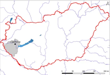
A photograph by Google Earth called our attention at the beginning of 2017 to a large, circular-shaped feature that was located in Gesztenyés-dűlő, west of Ligetfalva, in the centre of Zala County (Fig. 1).
Based on the shape and size of the discolouration clearly visible in the satellite image, we presumed that we discovered a formerly unknown Neolithic circular enclosure. The geographical location of the
feature captured in the satellite image also made it highly probable that we identifi ed a Neolithic roundel.2
Data collection
During the course of preliminary research in our data- base it became obvious that we identifi ed a new site,
Fig. 1 Geographical situation of the Ligetfalva, Gesztenyés-dűlő site. Basic map: data2.openstreetmep.hu; Catchment
Characterisation and Modelling (CCM), graphic: István Eke.
which was previously unknown, and whose con- nection to known and already registered sites was not clear at that time. The site was not mentioned in the offi cial archaeology database; however, we ma- naged to collect archived aerial photographs from the aerial photograph archives (www.fentrol.hu) of the Institute of Geodesy, Cartography and Re- mote Sensing (Fig. 2), in which the discolouration under examination could be identifi ed.3 During the course of a thorough examination of the archived photographs it turned out that the image of the feature in the photographs taken in the 1980s was diff erent from what was depicted in the currently available satellite images since in the former a more complex structure was visible. The diff erence with a high degree of probability could be caused by aggravated erosion due to intensive agricultural cultivation during the past few decades. Today there is a small acacia forest in the plot of land adjacent to the north-eastern part of the circular enclosure, which was under arable farming in the photograph taken in 1983.
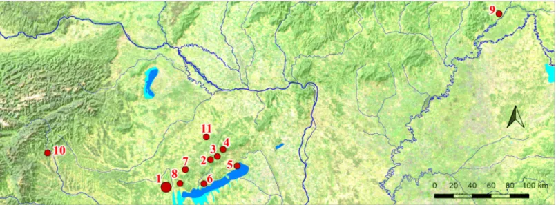
In Zala County at present we have knowledge of altogether seven genuine circular enclosures from the Lengyel culture (Fig. 3). The geographical locations of the sites are clearly indicative of the present status of research activities: the discovery of earlier
known sites is the result of rescue excavations in the Kis-Balaton (Little Balaton) area and the excavations conducted along the track of the M7 motorway. The three new sites identifi ed by our research group (Gétye, Gyomgyáló lejtős, Bezeréd, Teleki-dűlő II.
and Ligetfalva, Gesztenyés-dűlő) are all located in the micro-region named Zalaapáti-hát researched by our group.
Fig. 3 Late Neolithic circular enclosures (roundels) in Zala County:
1: Becsehely, Gesztenyési-földek, 2: Sormás, Török-földek I.,
3: Nagykanizsa, Palin-Anyagnyerőhely, 4: Balatonmagyaród, Hídvégpuszta, 5: Gétye, Gyomgyáló lejtős,
6: Ligetfalva, Gesztenyés-dűlő, 7: Bezeréd, Teleki-dűlő II.
Copernicus Land Monitoring Service, 2018;
data and graphic: István Eke.
Fig. 2 Archive aerial photography of the roundel
at Ligatfalva, Gesztenyés-dűlő taken in 1983 (www.fentrol.hu).
Geographical location
A general geographical characteristic of Neolithic circular enclosures is that they usually lie in the vicinity of waters however not close to larger rivers, but rather next to tributaries. The roundel at Ligetfalva is located in the northern part of the Zalaapáti Ridge micro- region on one of its southern slopes that is part of a hill running from north to south (Fig. 4). The Zalaapáti Ridge is a long hill running from north to south with a wider edge in its southern part located between two areas named Principális and Alsó-Zala-völgy (Lower Zala Valley). It is a highly eroded derasion hill; the surface is extraordinarily articulated especially in the northern part, where there are signifi cant diff erences in altitudes characteristic to medium mountains. The fundamental structural features in this region are the oblique faults staggering downwards to the south and sloping steeply from west to east. The eastern edge along the River Zala is a fl uvial platform, the slopes and platforms are highly eroded. As for its geological structure, brown glacial loam covering the Pannonian foundation mass is a main feature. Furthermore, there is a signifi cant amount of loess and loess sediment in this area. The climate is moderately cool and wet. In the northern part small streams drain surface waters into the River Zala (Dövényi 2010, 417–418).
The circular enclosure is located on the southern slope of a hill that is signifi cantly more elevated than its environment. It lies 20 m lower than the peak of the hill, at an elevation of approximately 230 m a.s.l.
on the slope. There are gentle slopes on the western and southern sides of the hill, while the eastern side is much steeper. The fact that it is located on the southern slope is quite revealing since based on data collected so far, this is the most typical location for roundels in Transdanubia. The River Zala is at a distance of approximately 3.8 km east of this site.
Two branches of the Ligetfalvi stream are situated in the immediate vicinity of the site in the east and west respectively; these branches have their confl uence at the southern foot of the hill. Based on the features described above we may come to the conclusion that the roundel at Ligetfalva is also located in a geographical and topographical environment that is generally characteristic for roundels in Transdanubia.
The distribution of sites with roundels according to micro-regions is as follows: three sites (Fig. 3. 5–7) Fig. 4 The environment of the site as seen from the south. The white arrow shows the location of the roundel. Photo: Judit P. Barna.
are located on the Zalapáti Ridge, one site (Fig. 3. 3) is located on the boundary of the Zalaapáti Ridge and the Principális Valley, while one site lies in the micro- region named Egerszeg–Letenyei-Downs (Fig. 3. 2), and another one in the Little Balaton Basin (Fig. 3. 4), the latter is situated also on a hillside. One site (Fig. 3.
1) is located in a diff erent environment on a plain on the left bank of the River Mura.4
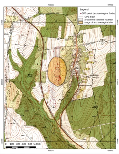
Field survey
As a fi rst step in our research activity, we conducted an archaeological land survey on 27. March 2017, during which – mainly due to highly limited sighting conditions – we collected a minimum quantity of archaeological fi nds from the soil surface. During the fi eld survey we used GIS-based data recording, and the original positions of the fi nds were determined by hand-held GPS units (Fig. 5). We did not use the method of sherd counting. Grog-tempered and red painted ceramic fragments dating to the late Neolithic Lengyel culture, furthermore, stone utensil fi nds corroborated our assumption that the feature in the satellite image was a circular enclosure from the late Neolithic period. Apart from ceramic material from the Neolithic period, we also collected a negligible quantity of ceramic fragments from the modern period. No other fi nds from any period was
identifi ed. It is worth mentioning that the traces of the one-time roundel and banks are visible on the soil surface to the naked eye even today. Based on our sightings we assume that the area has been disturbed to a lesser extent. Considering the scattered location of the fi nds on the soil surface and the topographic features, the size of the site can be estimated to occupy an area of approximately 500×300 m.
E V A L U A T I O N O F T H E F I N D S C O L L E C T E D F R O M T H E S O I L S U R F A C E D U R I N G T H E F I E L D S U R V E Y S
Evaluation of the ceramic material
We conducted multiple archaeological land surveys in the area in diff erent seasons, in spring, summer and early autumn,5 during which in various research conditions and despite varied vegetation and coverage, a relatively low quantity of fi nds was identifi ed. We collected most of these fi nds in the vicinity of the roundel however not from within the ditches or among them, but outside of these, from the area of the settlement.
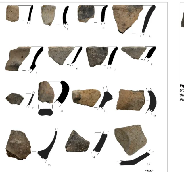
The ceramic fragments found on the site were rather worn and small in size; they were between 1 and 4.5 cm. (Figs. 6–7). They were sand and grog-tempered, we found only few coarse sand and gravel tempered
Fig. 5 Topographical position of the Ligetfalva roundel and the route of the fi eld survey. Scale= 1 : 10 000.
Data and map: István Eke.
artefacts. Most of them were side fragments (Fig. 6. 9, 11–14), and we found only a few rim and a couple of bottom fragments (Fig. 6. 1–8; and Fig. 6. 15). Mainly coarse ceramic pieces were found and a small number of thin-walled fi ne ceramic fragments (Fig. 6.
1–3, 6, 9; Fig. 7. 1–2). The high degree of fragmentation made it diffi cult to determine the form of vessels also therefore in this study in most cases no de- scription of vessels is provided due to the lack of characteristic and spectacular pieces. Among the low number of artefacts we could see small traces of red painting applied after fi ring on the external side on two fragments only (Fig. 7. 1–2). This can partly be explained by exposure to weather as it was indeed surprising that at least the act of painting could be established. Both pieces were of grey colour, the walls were 3 mm thick, and they were both curved side fragments. They can probably be identifi ed as pieces of thin-walled drinking vessels. Plastic elements among the fi nds collected are represented only by one sherd with the fragment of a knob (Fig. 6. 11) and the fragment of a handle(?) (Fig. 6. 10).
It is worth mentioning that ceramic pieces with a wall thickness similar to that of an eggshell made of well- levigated material were also present (Fig. 6. 9). The most signifi cant fi nd collected here was a fragment of a tiny, grey, well-fi red footed vessel, on which
three of the originally four small, short feet and a Fig. 6 Ceramic fi nds collected from the ground surface during the fi eld surveys. Photo: József Bicskei.
Fig. 7 Pottery fragments with traces of red paint collected during the fi eld surveys.
Photo: József Bicskei.
part of the body of the vessel could be identifi ed (Fig. 8). A perfect formal parallel of this artefact is known from feature 322 at Sormás, Török-földek (P. Barna 2017, Table 11.6). At that site a fragment of a vessel that could be reconstructed was also unearthed (P. Barna 2017, Type Table XIX. 6; Table 75.116), based on which the fragment found at Ligetfalva might be identifi ed as the lower part of a miniature footed pot.
The fi nds can clearly be dated to the Lengyel culture;
however, a more exact dating can be outlined only with a degree of probability for the time being.
Based on a single rim fragment of a profi led bowl with an outward curving rim (Fig. 6. 5), and also on the presence of this form we can probably exclude dating this artefact to the formative phase (Lengyel 1a) characterised by soft profi les (Kalicz 1984, 281;
1998, 63; P. Barna 2017, 213; Type Table XIV). Similar bowls – pedestalled bowls – were found in a low number at Sormás, Török-földek dating to Lengyel 1b, the last habitation phase (phase 4b) of this settlement (P. Barna 2017, 214; Type Table XV. 7).
Profi led bowls were common in the early phase of the Lengyel culture (Lengyel I), e. g. the IIIA type found at Aszód represents this form, and it could be found also as a part of pedestal bowls (Siklósi 2013, 98; Fig.
38), and this form can also be found in south-eastern
part of Transdanubia (Zalai-Gaál 2007, Abb. 5, 1; Abb. Fig. 8 Fragment of a miniature vessel with legs.
Photo: József Bicskei. Fig. 9 Polishers collected during the fi eld surveys.
Photo: Katalin T. Biró.
6, 3, Abb. 7, 2, etc.). It remained in use in the classic phase (phase II) of this culture, and specimens were found e. g. at Nagykanizsa, Palin-Anyagnyerőhely (Tokai 2017, Fig. 7. 5), in periods IV-V of Sé, Malomi- dűlő (Károlyi 1992, picture 42), in early features at the settlement at Veszprém, Jutasi út (Regenye – Biró 2014, Fig. 4. 4; Fig. 9. 2). The Sormás parallel of the four-footed miniature vessel can be dated to the end of the formative phase (4b settlement phase), to the Lengyel 1b phase (P. Barna 2017, 122). Nándor Kalicz dated the appearance of the eggshell-thin ceramic to the earliest phase of the Lengyel culture (Kalicz 1998, 62–63) however it appeared at Sormás, Török- földek only at the end of the formative phase and in the early Lengyel phase (4b settlement phase7).
The few and small fragments found on the soil surface may be indicative of a lesser disturbed status of the site, which at any rate would be fortunate in respect of research activities to be conducted later.
This is also confi rmed by the status of the surface, where the shape of the circular ditches and banks could relatively be well-detected as experienced during the land survey. As regards fi nds, we collected similar artefacts during the land survey we conducted at the multiple roundel at site II at the Bezeréd, Teleki-dűlő, which was discovered during the course of the past few years, and which, as far as we know at
present, is located closest to the roundel at Ligetfalva, Fig. 10 Chipped stone artefacts collected during the fi eld surveys.
Photo: Katalin T. Biró. Fig. 11 Lithic artefacts collected during the fi eld surveys.
Photo: Katalin T. Biró.
Detailed description of the lithic material can be presented accordingly. Codes used in Table 1 are marked bold and resolved accordingly (see T. Biró 1998, tables 6 and 7, respectively).
From the typological aspect (Fig. 12), the outstanding pieces in the small assemblage were a micro-blade- core (13/15, Fig. 10. 9) and a truncated blade, distal edge fragment (13/11, Fig. 10. 3), both characteristic during the late phase of the Lengyel culture, mainly on territories located North of Lake Balaton (T. Biró 1994, Regenye – T. Biró 2014).
As regards raw material (Figs. 13–14), the most important piece was an obsidian chip (C1 type, i.e. Slovakian obsidian). Several colour variants of Transdanubian radiolarite could be found in the small assemblage, mainly the mustard-yellow Úrkút-Eplény type. We could also observe sporadic occurrence of Sümeg radiolarian chert and Tevel fl int (uncertain occurrence), Triassic chert (‘hornstone’) of the Balaton Highlands, and probably the product of the Austrian
‘fl int mine’ around Rein (Brandl et al. 2015) was also represented here by two pieces. This would be the fi rst occurrence of the recently acknowledged raw material in Hungary. This hypothesis however should be further confi rmed by instrument-aided analytical methods.
although at that site we were able to survey a narrow strip of land due to seasonal coverage: we collected fi nds outside the ditches and not between them or within the area enclosed by them. We found but only a couple of fragments in the central part. Among the fi nds collected at that site there were only one or two artefacts on which we identifi ed traces of red paint (P. Barna et al. 2018, 217; 3. picture 8).
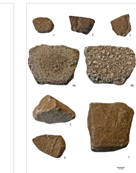
Evaluation of the lithic material
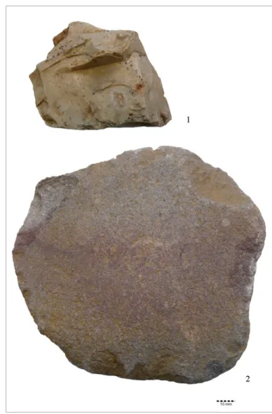
Before the date of the land survey no excavations had been performed on the site, only fi eld surveys and non-invasive investigation methods had been applied. The collected lithic material was a modest assemblage of 24 pieces summarised in Table 1. In the fi rst report (P. Barna et al. 2017), 22 pieces were included, the new artefacts (Fig. 11) fi tted well in the general prospect. From a typological aspect, most of the lithic material consisted of polishers (Fig. 9) and chipped stone artefacts of low elaboration stage (Fig. 10). In spite of this, we could fi nd objects of special interest for both typology and raw material studies.
Fig. 12 Typological distribution of the lithic artefacts.
Graphic: Katalin T. Biró.
Table 1 Summarising table of the main characteristics of the lithic material.
Inventory number Code of type Type Code of raw material Raw material Size (mm) Weight (g) Figure
polisher – small polisher with minor
Gy/2017 13/1 csi. injuries or traces of utilisation 51 medium fi ne grained sandstone, light yellowish gray 25 × 20 × 8 6.66 Fig. 9. 1 polisher with traces of utilisation – dark mottled
Gy/2017 13/2 csi. with traces of polishing a needle or an awl 52 coarse sandstone, calcareous sandstone breccia 60 × 44 × 21 85.21 Fig. 9. 4a–b T3 chert - ‘hornstone’ from Balaton-highland – grey with
Gy/2017 13/3 B4w small chip 45 fi nely striped pattern 12 × 13 × 3 0.58 Fig. 10. 1
fragment of raw material block
Gy/2017 13/4 A9 or precore, raw material? 50 fi ne grained sandstone, light coloured yellowish grey 30 × 35 × 40 61.27 Fig. 9. 5
Transdanubian radiolarite, other, with layer sheet cortex,
Gy/2017 13/5 A9 fragment of raw material block or precore, 15 orange-reddish brown colour 23 × 18 × 15 7.81 Fig. 10. 5
Gy/2017 13/6 B7/9 fragment of blade-like fl ake 999 other silex – Rein type? white 15 × 14 × 3 0.87 Fig. 10. 2
Gy/2017 13/7 B3 fl ake, core-fl ake 10 Transdanubian radiolarite, Úrkút-Eplény type, with porcelanite, 32 × 30 × 10 12.31 Fig. 10. 6 Gy/2017 13/8 csi9 polisher fragment, artefact? pigment? 51 medium fi ne grained sandstone, red – coloured by ochre or haematite 30 × 20 × 8 9.78 Fig. 9. 2
Gy/2017 13/9 B5w micro-blade, burnt and injured 999 other silex, radiolarite? 27 × 10 × 3 1.19 Fig. 10. 7
Gy/2017 13/10 tör. fragment, worked? 50 fi ne grained sandstone, yellowish grey 35 × 26 × 10 7.34 Fig. 9. 3
Gy/2017 13/11 D5/9 truncated blade fragment, small distal fragment 10 Transdanubian radiolarite, Úrkút-Eplény type 6 × 8 × 2 0.28 Fig. 10. 3
Gy/2017 13/12 B4 chip, with traces of bedrock cortex 914 Transdanubian radiolarite, Sümeg type? 20 × 22 × 10 3.78 Fig. 10. 11
Gy/2017 13/13 B4f pointed chip? 922 Tevel fl int? 30 × 10 × 5 1.34 Fig. 10. 12
Gy/2017 13/14 B4 chip 10 Transdanubian radiolarite, Úrkút-Eplény type, orange shade 24 × 14 × 3 1.34 Fig. 9. 8
Gy/2017 13/15 B2w micro-core remnant, with negatives of micro-blades 11 Transdanubian radiolarite, Hárskút type 20 × 15 × 7 3.84 Fig. 10. 9
Gy/2017 13/16 B4w small chip 10 Transdanubian radiolarite, Úrkút-Eplény type 10 × 12 × 2 0.39 Fig. 10. 10
Gy/2017 13/17 B4w small chip, 1 1 Carpathian (Slovakian) obsidian 12 × 20 × 3 0.71 Fig. 10. 4
Gy/2017 13/18 B2 core remnant, burnt, injured 9 Transdanubian radiolarite, Szentgál type with porcelanite 50 × 30 × 27 31.67 Fig. 10. 13 Gy/2017 13/19 B2 core remnant, with plane-like edge 10 Transdanubian radiolarite, Úrkút-Eplény type, with porcelanite 45 × 30 × 20 31.44 Fig. 10. 14
core remnant, triangular form,
Gy/2017 13/20 B2 used from several directions 10 Transdanubian radiolarite, Úrkút-Eplény type with porcelanite 30 × 28 × 30 24.45 Fig. 10. 15
Gy/2017 13/21 csi. polisher 50 fi ne grained sandstone, light colour yellowish grey 55 × 60 × 20 136.94 Fig. 9. 7
Gy/2017 13/22 csi. polisher 50 fi ne grained sandstone, light colour yellowish grey 40 × 36 × 10 17.33 Fig. 9. 6
Gy/2017 13/23 B2 core remnant 999 others Rein silex(?), white 55 × 75 × 27 113.3 Fig. 11. 1
Gy/2017 13/24 őrl. grinding stone, hand-held type with small injuries 51 medium sandstone, reddish grey (Balaton Highlands) 133 × 127 × 30 506.73 Fig. 11. 2
and banks could be sensed in the fi eld. Though the presence of these features meant a height diff erence of approximately 20–30 cm in the terrain only, the location of the one-time ditches and banks were clearly visible even so after harvest in the land under arable farming. In order to corroborate, identify more exactly and document our presumption as well as to survey the topography of the area, we conducted aerial photography by a quad copter. We designated a nearly 2.5 ha area for our survey, which was larger
Fig. 13 Distribution of the raw materials of the lithic artefacts.
Graphic: Katalin T. Biró. Fig. 14 Contacts of the Ligetfalva, Gesztenyés-dűlő site on the basis of lithic raw materials. Key: 1: Ligetfalva; 2: Úrkút-Eplény type radiolarite; 3: Szentgál type radiolarite; 4: Hárskút type radiolarite; 5: Balatonalmádi red sandstone; 6: Balaton-Highland ‘hornstone’;
7: Sümeg silex; 8: Rezi hornstone; 9: Carpathian 1 (Slovakian) obsidian; 10: Rein type silex; 11: Tevel fl int.
Basic map: Balázs Holl, data: Katalin T. Biró.
than the area covered by the feature shown in the archived aerial photograph depicting the dimensions of the circular enclosure. In this way we did not map the roundel only, but also the adjacent area. Aerial photography was conducted from two diff erent heights. The fi rst series of photos was taken from a relative height of 30 m in order to record fi ner details, while the second series of photos was taken from a height of 80 m, with the intent of acquiring an overall view.
The other stone utensils in the lithic assemblage are represented so far by small polishers only, made of fi ne grain sandstone, collected probably not too far from the settlement.
Aerial photography by drone, terrain model development
It was already conspicuous during the course of the fi rst land survey that the location of the ditches
The survey was conducted on 27. May 2017 after the colza grown in the fi eld was harvested, which was not a most ideal period for classic aerial photography therefore we could not observe “crop marks” in the areas under arable farming. Even so, the weeds that appeared after ploughing and the sprouting rape, although hardly noticeably, provided the outline of the roundel in the orthophoto mosaic. However, the most important goal of aerial photography was to create a high precision terrain model of the environment of the presumed circular enclosure, on which the locations of the banks and ditches observed in the area could also be indicated.
In accordance with our goal, we succeeded in creating a high precision terrain model (DSM)8 of the environment of the roundel.
Based on the analysis of the topographic model generated from the aerial photographs, our presumption was only partially verifi ed. While it seemed that the aerial photograph taken in 1983 depicted a feature with a treble roundel, its ditches and the banks among them were not clearly visible in the model however the circular shape indicating the presence of the assemblage of a Neolithic roundel was visible if relief shading was applied (Fig. 15;
Mészáros et al. 2018, p. 221. Figure 2).
The high precision topographic model generated
on the basis of the aerial photographs provided Fig. 15 Image of the Ligetfalva Neolithic roundel on terrain model (fi vefold height distortion) after Mészáros et al. 2018 Fig. 2.
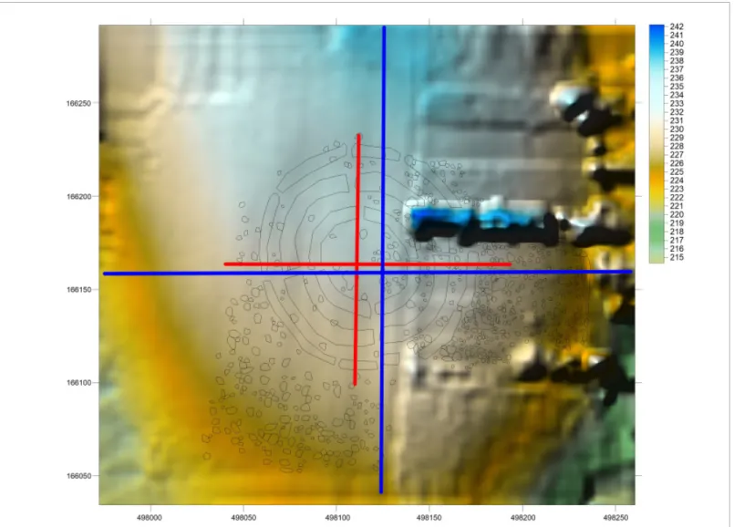
Fig. 16 Locations of the digital cross-sections drawn in order to investigate the environment of the roundel (blue line) and the area of the roundel (red line), respectively. Graphic: István Eke.
information also on the environment of the roundel.
In order to investigate the environment of the roundel, we drew an approximately 250 m long cross section running from north to south and a 300 m long cross section running from west to east (Fig. 16).
Based on the cross sections it could be established that – as it could also be observed during the land survey – the roundel lies on the southern slope of a hill running north to south, slightly under the highest peak of the hill. (Fig. 17.2). The western side of the hill is sloping gently, while there are steeper slopes on the eastern side (Fig. 17.1). Similarly to what we did when analysing the terrain, we also drew two perpendicular cross sections for the area of the roundel. By analysing the 180 m long cross section running west to east (Fig. 18.1) it can be seen that the innermost part of the roundel lies nearly 2 m higher than the edge of the external circular ditch and the western entrance. Such a diff erence cannot be observed in the 160 m cross section running north to south drawn for the roundel therefore the roundel lies on the ridge of the hill (Fig. 18. 2). The treble roundel system depicted in the aerial photograph could;
however, not be clearly verifi ed based on the terrain model therefore we also applied another non- invasive investigation method for the examination of the structure of the roundel.
The survey was conducted by a Sensys MXPDA magnetometer using Fluxgate probes, with which, by using changes in the magnetic fi eld of the earth, natural and artifi cial phenomena under the ground such as disturbances can be surveyed. During measuring gradient two probes placed one above the other can be used at the same time and, taking as a basic point the diff erence of the space values as measured by the probes, and by dividing these by the
Fig. 17 1: Digital cross-section in the west-east direction of the environment of the roundel. 2: Digital
cross-section in the north-south direction of the environment of the roundel. Graphic: István Eke. Fig. 18 1: Digital cross-section in the west-east direction of the area of the roundel. 2: Digital cross-section in the north-south direction of the area of the roundel. Graphic: István Eke.
layout and orientation characteristics of the roundel.
Máté Stibrányi and László Nagy conducted the geo- physical survey in September 2017, and the survey data were evaluated by Mihály Pethe. The area to be surveyed was determined based on aerial photographs and data collected during our land survey however fortunately the geophysical survey covered a somewhat larger area, so the size of the area surveyed amounted to a total of 24,200 m².
Geophysical survey, layout
As a next step we chose magnetic measurement among archaeological geophysical methods for the investigation of the site. With this method large areas can be surveyed during a short period of time, and by using it, one is capable of detect extraordinarily slight diff erences. By using the method of geophysical survey we purposefully wished to identify the size,
distance between the probes, the size of the vertical gradient is obtained at certain points. Measurements were conducted by fi ve pairs of probes simultaneously in the area researched. The pairs of probes were placed 50 cm apart, and the distance between the measurement points along the sections was 10 cm.
During measurements the instrument examined
the soil up to a depth of approximately 0.75-1 m, so it provided data for us from this maximum depth during the research activity. While measuring, we used JAVAD GNSS instruments operating in base- rover mode for centimetre-accurate positioning of the magnetometer.
As a fi rst step of processing we conducted error screening of raw data obtained from the measure- ments, and then the data resulting from this were reduced to pole in order that the magnetic anomalies move above the sources that triggered them. As a result of magnetic measurements, we acquired an extraordinarily clear, well-interpretable picture of the roundel (Fig. 19).
C O M B I N E D R E S U L T S O F T H E N O N - I N V A S I V E I N V E S T I G A T I O N S
Archaeological analysis of the roundel
Based on the geophysical survey, the picture of a roundel comprised of three circular ditches was outlined. In diameter the smallest, innermost circular ditch was 58 m, the medium one 91 m, and the largest one was 121 m, so the diameter ratio of the ditches with appropriate approximation was 2:3:4.
Neither of the ditches was regular circular in shape.
The smallest ditch was oval in shape, the north-south axis of which was longer. The middle one had a less distorted circular shape, and the largest one was also close to being circular in shape.
The innermost and the middle roundel had four entrances, while the largest one may have had eight entrances however these could not be identifi ed clearly.9 The entrances in all cases were probably constructed as earth bridges. They were oriented close to the four points of the compass and aligned along the same axis. If we regard the northerly direction on the map as 0°, then the eastern entrance was at 85⁰, the southern one was at 170⁰, the western one was at 260⁰, and the northern one was at 350⁰. At the external ditch two ruptions were clearly visible, one at 20° and the other one at 195°. The shape of two other ruptions was slightly vague; one of them was outlined at 212°, while the other one at 306°. At 115°
maybe one further vague rupture was visible (Fig. 20).
Most of the entrances represent a type that is surrounded by rounded edge ditches except for the ones along the middle ditch, where the end of the ditch was slightly wider at the western, southern and probably the eastern entrance. This type is also known in the case of other roundels (Neubauer, 2017, Abb. 3.2.1_21, 2). As in the case of the two other ditches, no “side wings”10 (straight supplementary ditches almost perpendicular to the main ditch) were Fig. 19 The result of vertical gradient measurement,
5 (blue) – -5 (red) nT/m.
attached to the middle ditch, either. However, at the northern and the southern entrances the edges of the middle ditch bent inwards. This structural feature may be regarded as an architectural precursor for the construction of perpendicular annexes.
There was a bank on the external side of the innermost ditch. A foundation ditch indicative of a palisade or anomalies indicating a row of post holes could not be identifi ed clearly; maybe such features were present on the internal side. Traces of a bank could also be established on the external rim of the middle ditch. Mention has already been made of the characteristic edges of the arcs of the middle ditch.
As we have mentioned before, we could not identify the exact number of entrances on the external ditch. The geomagnetic image of this ditch, which is ruptured in a diff erent manner compared to that of the entrances (see e. g. in the south-eastern quadrant, Fig. 19), allows us to presume that the roundel was constructed in diff erent stages, i. e. the whole ditch segments between the entrances were not excavated at the same time, but as a series of shorter segments. These small segments excavated separately were then joined at a higher elevation of the ditch section, and at those points the ditch segments were not excavated to the whole depth of the sections excavated earlier. Examples for a similar construction technique can be found at various sites
in Slovakia e. g. at Svodín (Nemejcová – Pavúková 1995), Austria at Kamegg (Trnka 1991, 92; Trnka 2012, Abb. 2f), Strögen (Neubauer 2017, 292; Abb.
3.2.1_24), Kleedorf (Neubauer 2017, Abb. 3.2.1_19), furthermore, at Moosbierbaum (Melichar – Neubauer 2010, Abb. 78, to the right). This part of the roundel may serve as evidence for the fact that in the case of monumental structures groups of labourers worked separately at certain sections of such structures (Neubauer 2017, 292).
There was no trace of bank at the external ditch however it can be presumed that there was a row of posts on the external part of the ditch. This may be indicated by a row of anomalies that refer to the presence of holes dug for posts or columns outlined in the south-western quadrant at an equal distance from the external ditch.
Dating and interpreting the site were greatly made relatively simple by the fact that we collected fi nds dating exclusively to the Lengyel culture on the ground surface at the site. The clear outline acquired by way of geophysical survey could also be interpreted appropriately due to the almost complete lack of superpositions. The roundel structure was extraordinarily regular, with symmetrical alignment.
The number of entrances (counting from inside to outward) was: 4 – 4 – 8(?). This fact as well as the design of the northern and southern entrance to
the middle ditch was indicative of the fact that the structure of the three circular ditches was not entirely identical. The fact whether this is the consequence of a chronological diff erence, could be made clear only by excavation methods. The entrances were constructed of simple earth bridges in all cases.
Fig. 20 The alignment values of the entrances of
the roundel, expressed in degrees, clockwise. N= 0° (360°).
Data: Emília Pásztor, graphic: Judit P. Barna.
The inner space surrounded by the innermost ditch, which in area is approximately 2,500 m², was free of geomagnetic anomalies that could be indicative of archaeological features. Clear traces of building structures or settlement features could not be identifi ed in this area therefore the roundel at Ligetfalva also corroborates the generally accepted opinion on the function of roundels that the enclosed parts of roundels were spaces separated from the inhabited parts of settlements also cut off physically from these by the ditches, and with all probability had a diff erent function.
One of the major and surprising outcomes of our land survey was that not only negative structures were preserved at the site, but also the trace of the one-time bank, which could also be sensed by the naked eye on the terrain in the fi eld of sprouting rape when we conducted our land survey in spring. Only a handful roundels are known with similar features, such as the one at Becsehely, Gesztenyési-földek11
and at the Třebovětice site (Moravia; Kovárník 2012;
Kovárník – Mangel 2013), which is dated to the Stroked-Pottery culture. The banks of an earthwork at Falkenstein, Schanzboden (Austria) dating to the Lengyel culture, as it was already mentioned in the introduction, can also be seen to this day (Neugebauer – Maresch 1995, 88–89; Abb. 40). For the time being we cannot provide details about the earthwork at the Ligetfalva roundel such as its height since further data could only be obtained by excavations, or Lidar survey.
Archaeoastronomical survey
Based on its layout the roundel at Ligetfalva, Gesztenyés-dűlő falls in the category of roundels with four entrances. The symmetrically located entrances and the remarkably regular layout characteristic to the roundels dating to the Lengyel culture indicate that a common construction principle was adhered
to during the construction of this roundel, or that the constructors were also creators of this principle.
There were various other characteristic features refl ecting this construction principle as follows:
The axes of the entrances are approximately per- pendicular.
The ratio of the diameters of the ditches is 2:3:4, which is the most common ratio regarding the diameters of treble roundels dating to the Lengyel culture.
The orientation of the entrance located on the eastern side is similar to that of the following roundels: Sé, Malomi-dűlő (Károlyi 1984; Kalicz 1984;
Kalicz 1998, 97) and Sormás, Török-földek I. (P. Barna 2007; P. Barna 2017, 175), and is identical with the orientation of the entrance on the eastern side of the roundel at Szemely, Hegyes I (Bertók et al. 2008, 95).
There was no special landscape element on the horizon that could have been used as a point of reference (Fig. 21), which also corroborates the Fig. 21 Panoramic view of the surroundings of the Ligetfalva roundel. Photo: Judit P. Barna.
assumption that something else, in our opinion a celestial phenomenon may have been the target of orientation.
The orientation values of the entrances (starting at the eastern entrance and proceeding clockwise)12 are as follows: 85⁰, 170⁰, 260⁰ and 350⁰. As regards the orientation features this roundel remarkably fi ts into our theory based on the investigation of roundels dating to the Late Neolithic Lengyel culture (Pásztor et al. 2008, Pásztor et al. 2014). According to this, the orientation of the eastern entrance was determined by the fi rst rays of the rising sun. By way of using these, the east–west diameter was set, at the ends of which the eastern (85⁰) and the western (260⁰) entrances were constructed (this was the reason why these two entrances were laid out along a straight line).
According to our theory, due to the periodical shift on the horizon of the sunrises, the values of eastern entrances were bound to be between 54° and 128°
(i. e. between the directions of the summer and winter solstices during the period of the Lengyel culture), which is true for this roundel. The directions of the two other entrances (on the northern and southern side) may have been determined by “geometric”
drafting (this was the reason why their axes are almost perpendicular to the line between the entrances on the eastern and western side). The topographic location of the roundel on the southern slope, which
made it possible to have the widest possible view on the course of the sun, also fi ts into our theory in which the importance of the role of the sun is emphasized.
The roundel at Ligetfalva in the context of roundels in Transdanubia and in the Lengyel complex
The roundels in Zala County have rather varied design features. Regarding their layout, their design range runs from the simplest single roundel to several diff erent variations such as dual and treble roundels with annexes. Within the period of the Lengyel culture their relative chronology also runs on a wide scale since even at the sites explored so far there are specimens dating to each developmental phase from the formative phase (roundel I at Sormás, Török- földek; P. Barna 2017, 187–193) through the classic phase (Nagykanizsa, Palin-Anyagnyerőhely; Tokai 2017) to the latest Lengyel period (Balatonmagyaród, Hídvégpuszta (Bánff y 1992, Bánff y 1996; P. Barna et al. 2019a).
We observed a very similar geographical location to that of the roundel at Ligetfalva (close to water, southern slope, steep slope in the east) earlier in the cases of the roundels at Sormás, Török-földek I and Gétye, Gyomgyálós lejtős respectively (P. Barna et al.
2019b).
Based on the analysis of a Google satellite image, the roundel discovered at the Ligetfalva site seemed to be a double roundel. For the geophysical survey we designated an area with a margin due to which we could also survey the line of the third, external ditch. Along the remains of a bank that was visible to the naked eye, we could also notice a phenomenon that can be rarely documented: the external ditch was probably not constructed by excavating the arcs between the entrances, but by opening adjacent shorter segments.
The diff erence in the number and design of the entrances in the case of the two internal and the external ditches as well as the slightly diff erent design of the northern and southern entrance in the case of the middle ditch may be indicative of a chronological discontinuity of the feature, which means that all the ditches of the roundel may not have been constructed during the same period of time. In contrast to this however the magnetic values measured in the ditches were quite uniform (3–5 nT). The curve has a steep peak at the ditch segment west of the southern entrance only (12 nT). Therefore, the geophysical measurement does not clearly indicate diff erent constructi-on periods, so this issue may be clarifi ed only by excavations.
Western Transdanubia was part not only of the formation of the Lengyel culture, but probably also
the area where the idea of roundels developed during that period (P. Barna – Pásztor 2011). This explains the phenomenon that the most regularly shaped roundels can be found here; however, the roundel at Ligetfalva is an outstanding specimen even in this environment due to its extraordinarily regular structure: as regards its layout, location, orientation, and presumed function it may be considered as the
“prototype”13 of Late Neolithic Lengyel-type roundels.
Summary: research outcomes of non-invasive investi- gation methods applied during the examination of the Neolithic roundel at Ligetfalva, Gesztenyés-dűlő:
• Detection of a new site, determination of its age (Neolithic, Lengyel culture) and characteristic features (settlement, roundel).
• Determination of the topographic location of the site and its spatial situation related to the other roundel sites in Zala County.
• Data collection for the determination of the connection between the settlement and the roundel.
• Examination of provenience of the lithic material provided data for the external connections of the site.
• With high probability part of the magnetic anomalies could be interpreted archaeologically: roundel, palisade, probably bank. At other sites, e. g. at Bezeréd, Teleki-dűlő II (P. Barna et al. 2018), Gétye,
Gyomgyálós lejtős (P. Barna et al. 2012; P. Barna et al. 2019b), etc., the annexes attached to the ditches of the roundels, large clay extracting pits, buildings, even the paths leading to the roundels could be determined with geophysical methods (Bertók et al.
2008, 95, picture 4; Bertók – Gáti 2014, 62).
• As an outcome of a clear picture resulting from the survey the layout and the main structural elements of the roundel could be established with a high degree of certainty. However, at this point mention must be made of the fact that features dating to all the periods could be observed at the same time.
• Establishment of the orientation features of the roundel. Probable excavations at the site would not change the locations of the entrances determining orientation.
• Conclusions may be drawn for the function of the roundel: a specially structured, enclosed space separated from a settlement. In the absence of anomalies that could be interpreted as dwelling houses it may be stated that the inner area was not a space for households.
During the investigation of the roundel at Ligetfalva various other issues came to light that could only be clarifi ed by excavations:
• The survey provides a picture of the present-day geophysical status of the site. Based on these, only
conclusions may be drawn for the status during the Neolithic period. Neither the rate of erosion, nor that of coverage is known. Pedological investigations and/or geological augerings would be necessary in order to acquire data about these features.
• The fi nds collected from the ground surface do not provide satisfactory clues for the accurate dating of the site within the Lengyel culture. Based on the currently available data it may only be suggested that concerning the site the terminus post quem is the onset of the formative phase (Lengyel 1a).
• Only fi nds to be collected from the bottom of the ditches could provide clues for the date of construction of the roundel however such fi nds are inaccessibly by non-invasive investigation methods.
• We do not have data concerning the construction periods of the roundel and the age of the ditches.
All this raises various questions that could be responded to if we had knowledge about the infi lling processes about which, apart from excavations, we could acquire information by analysing soil samples.
• Similarly, a more exact determination of the function of the roundel would be feasible by the examination of fi nds yielded by excavations and by pedological analyses of augered samples from the fi ll of the ditches.
• The age and function as well as the connection with the roundel system of the anomalies indicative of
the settlement features are not known. We do not have data concerning the stratigraphy of the site and the dynamics of the development of the settlement.
In summary of the above study we may conclude that the results of non-invasive investigations may raise new questions concerning the exploration of an archaeological site, and may provide assistance for a more exact determination of issues and also for raising issues prior to excavations however they cannot replace excavations. By conducting excavations we cannot only verify – or refute – presumptions based on the results of non-invasive investigations, but we can also collect data that are inaccessible by using other methods, so we can achieve the best results if we combine these two methods.
Notes
1. Among the two Neolithic earthworks at Falkenstein we refer to the younger and smaller, single circular enclosure dating to (Lengyel Ia/Ib–Lengyel Ib period), whose area is 2 ha.
2. Zsuzsa Miklós noticed this feature in 1995 already however she presumed that the circular discolouration in the soil was an earth fortress (verbal information by Dr. Judit Kvassay). Zalaegerszegi Göcseji Múzeum (ZGM) Archive of Zalaegerszeg Göcsej Museum 2327-2001.
3. The aerial photograph was taken on 9 December 1983, data accessed is 14 September 2017.
https://www.fentrol.hu/en/aerialphoto/135711
4. The site at Becsehely, Gesztenyési-földek for the time being was classifi ed as a roundel site based only on areal and satellite photographs and land survey data (Hungarian National Museum Archaeology Database, https://archeodatabase.hnm.hu/en/node/16131, data accessed 16 March 2019).
5. On 27 March 2017, on 25 July 2017 and on 13 September 2017.
6. Feature 93.
7. E.g. feature 40, P. Barna 2017, Table 54, 4.
8. A Digital Surface Model (DSM) does not only include topographic elements, but also the height of features (buildings, plants). A higher resolution topographic model than this can be achieved by Lidar survey.
9. Another possible interpretation of the ruptures will be detailed below.
10. Torwange in German (see e. g.: Literski – Nebelsick 2012, 437).
11.Hungarian National Museum Archaeology Database, https://archeodatabase.hnm.hu/en/node/16131, data accessed 16 March 2019
12. Starting point is north to south, 0⁰=360⁰.
13. By “prototype” we mean a characteristic representative of a type that unites all the special features of a type, and not the oldest specimen of a type that serves as an example and a first representative of a type (https://
www.arcanum.hu/hu/online-kiadvanyok/Lexikonok- a-magyar-nyelv-ertelmezo-szotara-1BE8B/p-44572/
prototipus-46883/ data accessed: 05 December 2019), since the exact chronological position of the roundel is unknown.
References
Bánff y 1992 | Bánff y, Eszter: Funde der späten Lengyel- und frühen Balaton-Lasinja-Kultur im Kleinbalaton-Gebiet.
Probleme der Übergangs. Studia Praehistorica 11–12, 1992, 308–312.
Bánff y 1996 | Bánff y Eszter: Korarézkori körárok Balaton- magyaród-Hídvégpusztáról. In: Vándor László – Költő László (szerk.): Évezredek üzenete a láp világából (Régészeti kutatások a Kis-Balaton területén 1979-1992). Kaposvár–Zalaegerszeg 1996, 21–22.
P. Barna 2007 | P. Barna, Judit: A New Site of the Lengyel Culture in Sormás-Törökföldek (County Zala, South-Western Transdanubia). In: Kozłowski, Janusz K. – Raczky, Pál (eds.): The Lengyel, Polgár and related cultures in the Middle/Late Neolithic in Central Europe. Kraków 2007, 365–380.
P. Barna 2017 | P. Barna, Judit: The Formation of the Lengyel Culture in South-Western Transdanubia. Archaeolingua Series Maior 39. Budapest 2017.
P. Barna–Pásztor 2011 | P. Barna, Judit – Pásztor, Emília:
Diff erent ways of using space: traces of domestic and ritual activities at a Late Neolithic settlement at Sormás-Török- földek. Documenta Praehistorica 38, 2011, 1–22.
https://doi.org/10.4312/dp.38.15
P. Barna et al. 2012 | P. Barna Judit – Eke István – Puszta Sándor – Puszta Adrián – Busznyák János – Tokai Zita Mária – T. Biró Katalin – Pásztor Emília – Száraz Csilla: Késő neoliti- kus körárok magnetométeres felmérése Gétyén. In: Füleky Gyula (szerk.) A táj változásai a Kárpát-medencében. Történel- mi emlékek a tájban. 9. Tájtörténeti Konferencia kiadványa.
Gödöllő 2012, 10–11, 135–139.
P. Barna et al. 2017 | P. Barna Judit – Eke István – Tokai Zita – Stibrányi Máté – Mészáros János – Pásztor Emília – T. Biró
Katalin: Észrevételek a neolitikus körárkok kutatásának mód- szereihez. Történeti táj – tájrégészet: eredmények és perspek- tívák a magyarországi tájrégészeti kutatásban, MTA BTK Régészet Intézet, 2017. november 6–7. Absztrakt kötet. Budapest 2017, 58.
P. Barna et al. 2018 | P. Barna Judit – Tokai Zita Mária – Eke István – Pásztor Emília – T. Biró Katalin – Mesterházy Gábor – Pethe Mihály: Bezeréd-Teleki-dűlő 2. Egy késő neolitikus körárok a Kr. e. 5. évezredből – Bezeréd-Teleki-dűlő 2. – A Late Neolithic circular enclosure from the 5th Millennium BC.
Archaeologiai Értesítő 143, 2018, 215–232.
https://doi.org/10.1556/0208.2018.143.11
P. Barna et al. 2019a | P. Barna, Judit – Bánff y, Eszter – Fullár, Zoltán – Serlegi, Gábor: Enclosure and Settlement from the Mid-5th Millennium BCE at Balatonmagyaród-Hídvégpuszta.
In: Bánff y, Eszter – P. Barna, Judit (Hrsg.): „Trans Lacum Pelsonem”. Prähistorische Forschungen in Südwestungarn (5500–
500 v. Chr.). Prehistoric Research in South-Western Hungary (5500–500 BC). Castellum Pannonicum Pelsonense 7. Rhaden/
Westf. 2019, 117–160.
P. Barna et al. 2019b | P. Barna, Judit – Tóth, Brigitta – Pásztor, Emília – Tokai, Zita Mária – T. Biró, Katalin – Puszta, Sándor – Eke, István – Puszta, Adrián – Busznyák, János – Kocsis, Napsugár – Tugya, Beáta – Száraz, Csilla: Non-invasive Investi- gations of a Late Neolithic Roundel at Gétye, Western- Hungary. In: Bánff y, Eszter – P. Barna, Judit (Hrsg.): „Trans Lacum Pelsonem”. Prähistorische Forschungen in Südwest- ungarn (5500–500 v. Chr.). Prehistoric Research in South-Western Hungary (5500–500 BC). Castellum Pannonicum Pelsonense 7.
Rhaden/Westf. 2019, 73–94.
Bertók et al. 2008 | Bertók Gábor – Gáti Csilla – Vajda Olga:
Előzetes jelentés a Szemely-Hegyes lelőhelyen (Baranya megye) található neolitikus körárok-rendszer kutatásáról
– Preliminary report on the research at the Neolithic Kreis- grabenanlage at Szemely-Hegyes, Baranya County, Hungary.
Archaeologiai Értesítő 133, 2008, 85–106.
https://doi.org/10.1556/ArchErt.133.2008.1.5
Bertók–Gáti 2014 | Bertók Gábor – Gáti Csilla: Régi idők – új módszerek. Budapest 2014.
T. Biró 1994 | T. Biró Katalin: A Szentgál, Füzi-kúti későneolit település kőanyaga – Lithic material of the Late Neolithic settlement Szentgál, Füzi-kút. A Veszprém Megyei Múzeumok Közleményei 19, 1994, 89–118.
T. Biró 1998 | T. Biró, Katalin: Lithic implements and the circula- tion of raw materials in the Great Hungarian Plain during the Late Neolithic Period. Budapest 1998, 1–350.
Brandl et al. 2015 | Brandl, Michael – Martinez, Maria M. – Modl, Daniel – Weiss-Krejci, Estella: Chert from the Rein Basin (Styria, Austria): Prehistoric use and distribution. In:
Kerig, Tim – Shennan, Stephen (eds.): Connecting Networks.
Characterising Contact by Measuring Lithic Exchange in the European Neolithic. Oxford 2015, 103–115.
https://doi.org/10.2307/j.ctv1pzk1hm.14
Dövényi 2010 | Dövényi Zoltán (szerk.): Magyarország kis- tájainak katasztere. Budapest 2010.
Kalicz 1984 | Kalicz, Nándor: Übersicht über den Forschungs- stand der Entwicklung der Lengyel–Kultur und die älteste
„Wehranlangen” in Ungarn. In: Eibner, Alexandrine – Kaus, Margarete – Urban, Otto (Hrsg.): Symposium Poysdorf 1983.
Mittelneolithische Grabenanlagen (Kult- Befestigungsanlagen in Zentraleuropa. Poysdorf – Laa Thaya (Niederösterreich) 9. und 10.
April 1983. Mitteilungen der Österreichischen. Arbeitsgemen- schaft für Ur- und Frühgeschichte 33–34. Wien 1984, 271–293.
Kalicz 1998 | Kalicz, Nándor: Figürliche Kunst und bemalte Keramik aus dem Neolithikum Westungarns. Archaeolingua Series Minor 10. Budapest 1998.
Károlyi 1984 | Károlyi, Mária: Ergebnisse der Ausgrabungen bis 1980 in der befestigsten Ansiedlung von Sé, Westungarn.
In: Eibner, Alexandrine – Kaus, Margarete – Urban, Otto (Hrsg.):
Symposium Poysdorf 1983. Mittelneolithische Grabenanlagen (Kult- Befestigungsanlagen in Zentraleuropa. Poysdorf – Laa Thaya (Niederösterreich) 9. und 10. April 1983. Mitteilungen der Öster- reichischen. Arbeitsgemenschaft für Ur- und Frühgeschichte 33–34. Wien 1984, 293–308.
Károlyi 1992 | Károlyi Mária: A korai rézkor emlékei Vas megyében – The Early Copper Age in County Vas. Őskorunk 1.
Szombathely 1992.
Kovárník 2012 | Kovárník, Jaromír: Měly mladoneolitické rondely také valy? Aneb je rondel s valy u Třebovětic, okr.
Jičín, klíčem k řešení? – Did early Neolithic roundels have ramparts? Is the roundel with ramparts near Třebovětice, Jičín Dist. a key to the solution? Živá archeologie. (Re)konstrucke a experiment v archeologii 2012/14/1, 9–15.
Kovárník–Mangel 2013 | Kovárník, Jaromír – Mangel, Tomas:
Rondel s valy u Třebovětic. Poznámka ke konstrukčním znakům mladoneolitických rondelů. In: Cheben, Ivan – Soják, Marián (eds.): Otázky neolitu a eneolitu našich krajín – 2010.
Zborník referátov z 29. pracovného stretnutia bádateľov pre výskum neolitu a eneolitu Čiech, Moravy a Slovenska. Vršatecké Podhradie, 27.–30. 9. 2010. Archaeologica Slovaca Mono- graphiae 15. Nitra 2013, 133–152.
Lenneis 2017 | Lenneis, Eva: Erdwerke als Schutz der Sied- lunge. In: Lenneis, Eva (Hrsg.): Erste Bauerndörfer – älteste Kult- bauten: Die frühe und mittlere Jungsteinzeit in Niederösterreich.
Archäologie Niederösterreichs 1. Wien 2017. 309–313.
https://doi.org/10.2307/j.ctvdmwxx3
Literski–Nebelsick 2012 | Literski, Norma – Nebelsick, Louis D.:
Katalog der Kreisgrabenanlagen und verwandten Tells der ersten Hälfte des 5. Jt. v. Chr. in Mittel- und Südeuropa. In:
Bertemes, François – Meller, Harald (Hrsg.): Neolithische Kreis- grabenanlage in Europa. Internationale Arbeitstagung 7.–9. Mai 2004 in Goseck (Sachsen-Anhalt) – Neolithic Circular Enclosures in Europe. International Workshop 7th–9th May 2004 in Goseck (Saxony-Anhalt, Germany). Tagungen des Landesmuseum für Vorgeschichte, Halle 8. Halle (Saale) 2012, 433–532.
Mészáros et al. 2018 | Mészáros János – Bíró Csaba – Pánya István – Eke István – P. Barna Judit: A talaj szerepe a tájrégé- szetben – kis reliefű területek roncsolásmentes vizsgálata UAV eszköz segítségével. In: Molnár Vanda Éva (szerk.): Az elmélet és a gyakorlat találkozása a térinformatikában 9. Theory meets practice in GIS. Debrecen 2018, 219–226.
Melichar–Neubauer 2010 | Melichar, Peter – Neubauer, Wolfgang (Hrsg.): Mittelneolithische Kreisgrabenanlagen in Niederösterreich. Geophysikalisch-archäologische Prospektion - ein interdisziplinäers Forschungsprojekt. Mitteilungen der Prähistorischen Kommission 71. Wien 2010.
https://doi.org/10.1553/0x0013e337
Němejcová-Pavúková 1995 | Němejcová-Pavúková, Viera:
Svodín. Zwei Kreisgrabenanlagen der Lengyel-kultur. Bratislava 1995.
Neubauer 2017 | Neubauer, Wolfgang: Kreisgrabenanlagen (4850/4750–4650/4500 BC). In: Lenneis, Eva (Hrsg.): Erste Bau- erndörfer – älteste Kultbauten: Die frühe und mittlere Jungstein- zeit in Niederösterreich. Archäologie Niederösterreichs 1. Wien 2017, 276–296.
Neugebauer-Maresch 1995 | Neugebauer-Maresch, Christine:
Mittelneolthikum: Die Bemaltkeramik. In: Lenneis, Eva – Neugebauer-Maresch, Christine – Elisabeth Ruttkay (Hrsg.):
Die Jungsteinzeit im Osten Österreichs. Wissenschaftliche Schriftenreihe Niederösterreich 102–105, Forschungsberichte zur Ur- und Frühgeschichte 17. St. Pölten–Wien 1995, 57–107.
Pásztor et al. 2008 | Pásztor, Emília – P. Barna, Judit – Roslund, Curt: The Orientation of Roundels of the Neolithic Lengyel Culture in Central Europe. Antiquity 82, 2008, 910–924.
https://doi.org/10.1017/S0003598X00097672
Pásztor et al. 2014 | Pásztor, Emília – P. Barna, Judit – Zotti, Georg: Neolithic Circular Ditch Systems (“Rondels”) in Central Europe. In: Ruggles, Clives L. N. (ed.): Handbook of Archaeoastronomy and Ethnoastronomy. New York 2015, 1317–1326.
https://doi.org/10.1007/978-1-4614-6141-8_127
Regenye–T. Biró 2014 | Regenye Judit – T. Biró Katalin:
Veszprém, Jutasi út neolitikus település leletanyaga 1.
Kerámia, kő – Finds from the Neolithic settlement Veszprém, Jutasi street 1. Ceramics and lithics. A Laczkó Dezső Múzeum Közleményei 28, 2014, 29–74.
Siklósi 2013 | Siklósi, Zsuzsanna: Traces of social inequality during the Late Neolithic in the Eastern Carpathian Basin.
Dissertationes Pannonicae (ex Instituto Numismatico et Archaeologico Universitatis de Petro Pázmány nominatae Budapestinensis provenientes) Ser. 4. Vol. 3. Budapest 2013.
Tokai 2017 | Tokai Zita Mária: Nagykanizsa-Palin – Anyag- nyerőhely – egy központ a lengyeli kultúra idejéből 1. Nagy- kanizsa-Palin – Anyagnyerőhely – a centre from the age of Lengyel culture 1. Zalai Múzeum 23, 2017, 7–30.
Trnka 1991 | Trnka, Gerhard: Studien zu mittelneolithischen Kreisgrabenanlagen. Mitteilungen der prähistorischen Kommission 26. Wien 1991.
Zalai-Gaál 2007 | Zalai-Gaál, István: Zengővárkony – Svodín – Friebritz: Zu den chronologischen Beziehungen zwischen den territorialen Gruppen der Lengyel-Kultur aufgrund der Gräberfeldanalyse. In: Kozłowski, Janusz K. – Raczky, Pál (eds.):
The Lengyel, Polgár and related cultures in the Middle/Late Neolithic in Central Europe. Kraków 2007, 147–184.