ungar ian H istor ical R eview N atur al R esour ces and Society 9/2 | 2020
New Series of Acta Historica Academiæ Scientiarum Hungaricæ
2020
volume number
9 2
Natural Resources and Society
Natural Resources and Society
Contents
Éva Bodovics 179 Sándor Rózsa 213 Beatrix F. Romhányi, Zsolt Pinke,
József Laszlovszky 241 Miklós Kázmér,
Erzsébet Győri 284 András Grynaeus 302 Viktória Kiss 315 Zoltán Czajlik 331 Weather Anomalies and Their Economic Consequences
Evaluation of the Floodplain Farming Environmental Impacts of Medieval Uses of Natural Resources
Millennial Record of Earthquakes
Dendrochronology and Environmental History:
The Difficulties of Interpretation
Transformations of Metal Supply during the Bronze Age Distribution of Stone Raw Materials in the Late Iron Age
Editor-in-Chief
Pál Fodor (Research Centre for the Humanities) Editors
Péter Apor (RCH), Gabriella Erdélyi (RCH), Sándor Horváth (RCH), Judit Klement (RCH), Veronika Novák (Eötvös Loránd University of Budapest), Tamás Pálosfalvi (RCH),
András Vadas (Eötvös Loránd University / CEU), Bálint Varga (RCH) Review Editors
Veronika Eszik (RCH), Judit Gál (Eötvös Loránd University), Janka Kovács (Eötvös Loránd University), Réka Krizmanics (CEU), Tamás Révész (RCH)
Editorial Secretaries
Gábor Demeter (RCH), Judit Lakatos (RCH) Editorial Board
Attila Bárány (University of Debrecen), László Borhi (RCH), Gábor Czoch (Eötvös Loránd University of Budapest), Zoltán Csepregi (Evanglical-Lutheran Theological University), Gábor Gyáni (RCH), Péter Hahner (University of Pécs), György Kövér (Eötvös Loránd University of Budapest), Géza Pálffy (RCH), Attila Pók (RCH), Béla Tomka (University of Szeged), Attila Zsoldos (RCH)
Advisory Board
Gábor Ágoston (Georgetown University), János Bak (Central European University), Neven Budak (University of Zagreb), Václav Bu˚žek (University of South Bohemia), Olivier Chaline (Université de Paris-IV Paris- Sorbonne), Jeroen Duindam (Leiden University), Robert J. W. Evans (University of Oxford), Alice Freifeld (University of Florida), Tatjana Gusarova (Lomonosov Moscow State University), Catherine Horel (Université de Paris I Panthéon-Sorbonne), Olga Khavanova (Russian Academy of Sciences), Gábor Klaniczay (Central European University), Mark Kramer (Harvard University), László Kontler (Central European University), Tünde Lengyelová (Slovakian Academy of Sciences), Martyn Rady (University College London, School of Slavonic and East European Studies), Anton Schindling (Universität Tübingen), Stanislaw A. Sroka (Jagiellonian University), Thomas Winkelbauer (Universität Wien)
INDEXED/ABSTRACTED IN: CEEOL, EBSCO, EPA, JSTOR, MATARKA, Recensio.net.
geographical scope—Hungary and East-Central Europe—makes it unique: the Hungarian Historical Review explores historical events in Hungary, but also raises broader questions in a transnational context. The articles and book reviews cover topics regarding Hungarian and East-Central European History. The journal aims to stimulate dialogue on Hungarian and East-Central European History in a transnational context. The journal fills lacuna, as it provides a forum for articles and reviews in English on Hungarian and East-Central European history, making Hungarian historiography accessible to the international reading public and part of the larger international scholarly discourse.
The Hungarian Historical Reviews
(Formerly Acta Historica Academiæ Scientiarum Hungaricæ) 4 Tóth Kálmán utca, Budapest H – 1097 Hungary Postal address: H-1453 Budapest, P.O. Box 33. Hungary E-mail: hunghist@btk.mta.hu
Homepage: http: \\www.hunghist.org Published quarterly by the Institute of History, Research Centre for the Humanities (RCH).
Responsible Editor: Pál Fodor (Director General).
Prepress preparation by the Institute of History, RCH, Research Assistance Team;
Leader: Éva Kovács. Page layout: Imre Horváth. Cover design: Gergely Böhm.
Printed in Hungary, by Prime Rate Kft, Budapest.
Translators/proofreaders: Alan Campbell, Matthew W. Caples, Thomas Cooper, Sean Lambert, Thomas Szerecz.
Annual subscriptions: $80/€60 ($100/€75 for institutions), postage excluded.
For Hungarian institutions HUF7900 per year, postage included.
Single copy $25/€20. For Hungarian institutions HUF2000.
Send orders to The Hungarian Historical Review, H-1453 Budapest, P.O. Box 33.
Hungary; e-mail: hunghist@btk.mta.hu
Articles, books for review, and correspondence concerning editorial matters, advertising, or permissions should be sent to The Hungarian Historical Review, Editorial, H-1453 Budapest, P.O. Box 33. Hungary; e-mail: hunghist@btk.mta.
hu. Please consult us if you would like to propose a book for review or a review essay.
Copyright © 2020 The Hungarian Historical Review by the Institute of History, Research Centre for the Humanities.
All rights reserved. No part of this book may be reproduced, stored, transmitted, or disseminated in any form or by any means without prior written permission
New Series of Acta Historica Academiae Scientiarum Hungaricae
Volume 9 No. 2 2020
Natural Resources and Society
Gábor Demeter and Beatrix F. Romhányi Special Editors of the Thematic Issue
Contents
ARTICLES
Éva Bodovics Weather Anomalies and Their Economic Consequences: Penury in Northeastern Hungary
in the Late 1870s 179
sándor rózsa Evaluation of the Floodplain Farming of the Settlements of Nagykunság Based
on the First Cadastral Survey 213 Beatrix F. romhányi, Environmental Impacts of Medieval Uses
zsolt Pinke, of Natural Resources in the Carpathian
and JózseF laszlovszky Basin 241
miklós kázmÉr Millennial Record of Earthquakes in the
and ErzsébEt Győri Carpathian-Pannonian Region: Historical
and Archaeoseismology 284
andrás Grynaeus Dendrochronology and Environmental History:
The Difficulties of Interpretation 302 viktória kiss Transformations of Metal Supply during
the Bronze Age in the Carpathian Basin 315 zoltán czaJlik Along the Danube and at the Foothills of the
North-Eastern Hungarian Mountains: Some Data on the Distribution of Stone Raw Materials
in the Late Iron Age 331
BOOK REVIEWS
Ottoman Law of War and Peace: The Ottoman Empire and its Tributaries from the North of the Danube. By Viorel Panaite. Reviewed by Gábor Kármán 343 Tábori sebesültellátás Magyarországon a XVI–XVIII. században [Care for the wounded in the field in Hungary in the sixteenth, seventeenth, and eighteenth centuries]. By Katalin Mária Kincses. Reviewed by Katalin Simon 347 Styrian Witches in European Perspectives: Ethnographic Fieldwork.
By Mirjam Mencej. Reviewed by Gergely Brandl 350
The Habsburg Civil Service and Beyond: Bureaucracy and Civil Servants from the Vormärz to the Inter-War Years. Edited by Franz Adlgasser and
Fredrik Lindström. Reviewed by Mátyás Erdélyi 355
Az uradalom elvesztése: Nemesi családok a 19. századi Békés megyében
[The loss of the estate: Noble families in Békés County in the nineteenth century].
By Adrienn Szilágyi. Reviewed by Krisztián Horváth Gergely 358 Deszkafalak és potyavacsorák: Választói magatartás Pesten a Tisza Kálmán-
korszakban [Plank walls and freebee dinners: Voter behavior in Pest in the era of Kálmán Tisza]. By Péter Gerhard. Reviewed by Réka Matolcsi 362 Men under Fire: Motivation, Morale and Masculinity among Czech Soldiers
in the Great War, 1914–1918. By Jiří Hutečka. Reviewed by Tamás Révész 366 The Fortress: The Great Siege of Przemyśl. By Alexander Watson.
Reviewed by Kamil Ruszała 369
Tiltott kapcsolat: A magyar–lengyel ellenzéki együttműködés
1976–1989 [A forbidden relationship: Oppositional cooperation between Hungarians and Poles, 1976–1989]. By Miklós Mitrovits.
Reviewed by Ferenc Laczó 373
Dissidents in Communist Central Europe: Human Rights and the Emergence of New Transnational Actors. By Kacper Szulecki. Reviewed by Una Blagojević 377 Corn Crusade: Khrushchev’s Farming Revolution in the Post-Stalin Soviet Union.
By Aaron Hale-Dorrell. Reviewed by Alexandra Bodnár 380
Millennial Record of Earthquakes in the Carpathian- Pannonian Region: Historical and Archaeoseismology
Miklós Kázmér and Erzsébet Győri
Eötvös Loránd University, MTA–ELTE Geological, Geophysical and Space Science Research Group; Kövesligethy Radó Seismological Observatory
mkazmer@gmail.com
This is a short essay on earthquakes in the Carpathian-Pannonian region and its surroundings. Earthquakes have been recorded using seismographs since 1902 in Hungary. The relatively small number of seismic events and the long return period of major earthquakes make it necessary to use historical data in order to assess seismic hazard. Historical earthquake catalogues aim for exhaustiveness both in time and space, but they are limited by the lack of documentary data. A simple arithmetical assessment is provided to estimate our lack of knowledge of past seismic events. All destructive earthquakes of the twentieth century (above magnitude 5) are included in the catalogue (100%). Of the seismic events which took place in the seventeenth, eighteenth, and nineteenth centuries, only 23% are on record, while this figure drops to 4.6 percent for the eleventh–sixteenth centuries and 0.2 percent for the first millennium AD. On average, we have no information about 90% of the destructive earthquakes which occurred in the Carpathian-Pannonian region over the course of the past two millennia.
According to both instrumental measurements and historical sources, there were relatively few earthquakes in the central era of the period of time in question. This era coincides roughly with the two centuries of Ottoman rule (the sixteenth and seventeenth centuries). Were there really few earthquakes over the course of these two centuries, or we do not have the relevant records? We contend that warfare resulted in the destruction of settlements and the annihilation of documents.
Fragile historical documents can be supplemented by the study of robust edifices, an approach to the study of the past which is known as archaeoseismology. Evidence of damage and destruction can be identified, and earthquake parameters can be assessed. One can find evidence corroborating other sources indicating an earthquake (e.g. Savaria), and one can also identify traces of previously unknown seismic events (Visegrád). One can also assign intensity values to the existing historical records.
Damage observed to a Roman road in Savaria, to the medieval donjon of Nagyvázsony offers support for our fundamental contention. In order to understand the seismic hazard that was faced in the Carpathian-Pannonian region, renewed study of historical sources and new archaeoseismological investigations are needed.
Keywords: earthquakes, archaeoseismology, historical sources, Carpathian-Pannonian region
Introduction
Earthquakes cannot be predicted. There are abundant references on the internet and in the secondary literature concerning seismic events that allegedly were successfully forecast. Several natural anomalies were harbingers of the 1975 Haicheng event in China, and an evacuation order was issued by an exceptionally cautious civil protection leader, who was in a position of power at the time and who thus probably saved tens of thousands of lives. In contrast, there was no foreshock or any other kind of anomaly on the basis of which predictions might have been made concerning the 1976 Tangshan earthquake, which hit the city at night and caused at least 250,000 deaths. The few successful cases when an earthquake was predicted should be seen as lucky coincidences at most, not suitable for generalization.
1How can we reduce damage to people and property by earthquakes in the future? Anything that happened in the past can happen in the future. We therefore need to learn as much as we can about the past. This may help us prepare for events in the future.
2In the following, we provide a very short overview on the seismic history of the Carpathians and the Pannonian Basin.
Historical Seismology
Measurements of seismic activity using sophisticated instruments began in Hungary in 1902. For any moment before this date, we have data on seismicity based on historical documents only. Grossinger
3was the first to summarize these documents in a Latin catalogue published in 1783, immediately followed by a German translation of Sternberg,
4both of whom listed 150 events. A century later, Jeitteles
5described 220 earthquakes from the same period in great detail, noting felt features and damage. After a few short communications, Réthly
6published his monumental catalogue, listing events up to the end of 1917. Two hundred and thirty-five of these events are recorded from the same period as Grossinger. Réthly was the first to distinguish between main shock
1 Hough, Predicting the Unpredictable.
2 Ambraseys, “Archaeoseismology.”
3 Grossinger, Dissertatio.
4 Sternberg, Geschichte.
5 Jeitteles, “Geschichte der Erdbeben.”
6 Réthly, Kárpátmedencék.
and aftershocks. He gave catalogue entries in the original language and added Hungarian translations with references to the original sources. His catalogue is an exemplary work in every sense.
7Zsíros
8prepared a computerized catalogue containing more than 20,000 events. Most of the information concerning these events came from instrumental measurements taken after 1970. Comparing his methods with previous studies, we found that he increased the data given by Grossinger more than fourfold (!) for the period which came to an end in 1783. References are provided for all of the data. This catalogue has been supplemented by new data compiled using instruments by researchers at the Seismological Observatory in Budapest. Figures 1 and 2, which illustrate the temporal and spatial distribution of earthquakes in the Carpathian-Pannonian Basin, are based on this database.
Historical earthquake catalogues are prepared with the intent of making a complete listing of known events for a given area. The best examples to follow are the catalogues compiled by Guidoboni and Comastri
9for the Mediterranean region, by Ambraseys
10for the Mediterranean and the Middle East, and, to cite a local example, by Hammerl and Lenhardt
11for Lower Austria.
Our ability to provide a complete account of catalogue of seismic events, however, depends, of course, on the availability of sources. Hungary is characterized by a lack rather than an abundance of sources, in part because of its stormy history.
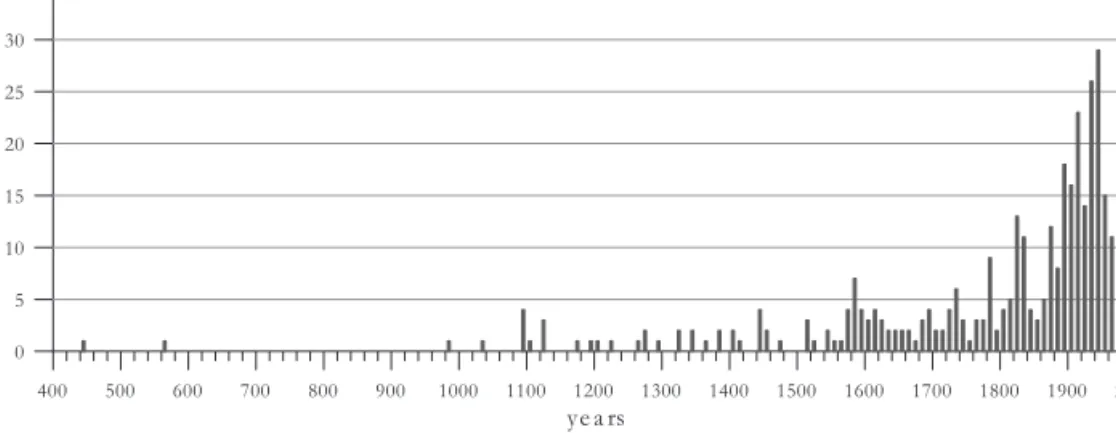
Earthquakes of magnitude 5 or larger are plotted by decade in Figure 1.
A magnitude 5 earthquake causes structural damage to buildings. Earthquakes and seismic events which took place after 1901 were measured using new instruments, so these measurements were used to plot them on the graph, while other sources, including narrative sources, were used to plot seismic events before this. The part of the graph which covers earthquakes of a magnitude of five or more in the twentieth century can be considered complete, as it is based on data provided by relatively sophisticated instruments. The graph offers the impression that, the further one goes back in time, the fewer earthquakes there were. Clearly, this is unlikely. This difference is a sign, rather, of the lack of sources.
7 Ambraseys, Earthquakes, 6.
8 Zsíros, “Earthquake activity.”
9 Guidoboni and Comastri, Catalogue.
10 Ambraseys, Earthquakes, 6.
11 Hammerl and Lenhardt, “Erdbeben.”
Figure 1. Number of known earthquakes in the Carpathian-Pannonian region and surroundings in the past two millennia. Magnitude 5 and larger events are shown for each
decade. See also Figure 2 for the investigated area.12
We assume that there were similar numbers of earthquakes in previous centuries. The locations and times of seismic activities are consequences of processes of plate tectonics, which hardly show significant variations over the course of centuries or even millennia.
13On average, there were 15 events every decade in the twentieth century, coming to a total of 205 earthquakes. The approximate parameters of these events are known. Between 1600 and 1900, sources indicate that there were on average five events per decade, coming to a total of 144 earthquakes, instead of the 615 ones if we assume that earthquakes occurred with the same frequency as in the twentieth century. This means that there are no records in the available sources of three fourths of the destructive earthquakes (which would mean 461 events). There are scattered records of earthquakes before 1600, including decades for which there are no indications that there were any earthquakes whatsoever. Between 1000 and 1600, the sources indicate only 57 earthquakes, which would be 4.6% of the 1,230 quakes which probably occurred. There are only three records of three earthquakes from the first millennium. In other words, if one were to rely entirely on these sources, one would conclude that 0.2% of all the earthquakes which occurred in the period of time covered in this discussion took place over the course of this period of 1,000 years (Fig. 1). If, in contrast, we were to make the logical assumption that earthquakes were as common in the first millennium as they were in the twentieth
12 Earthquake Catalogue.
13 Bada et al., “Present-day stress field.”
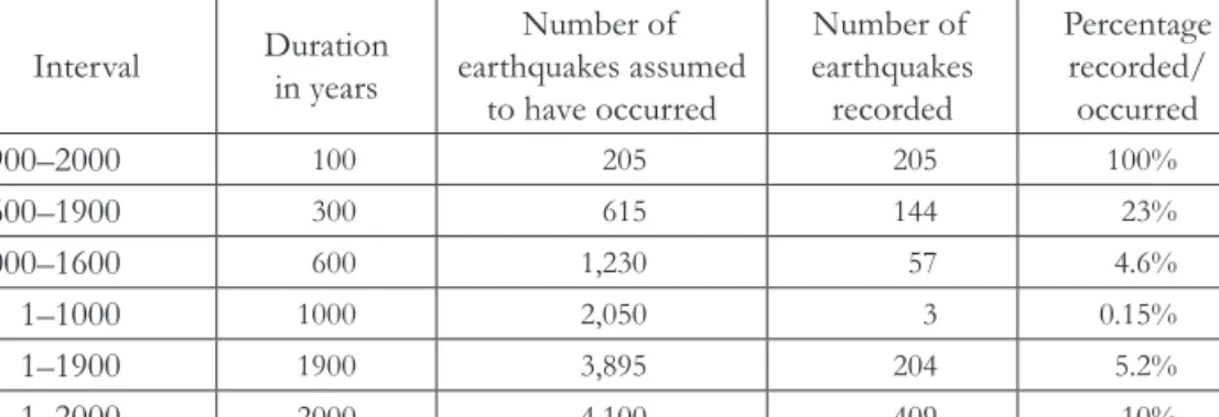
century, we can conclude that the sources make no mention of 99.8% of all earthquakes. Historical observations for 1 to 1900 AD indicate only 5.2 percent of the number of earthquakes which we can assume to have taken place. These are the earthquakes that are listed in the aforementioned catalogues. Calculations of seismic risks are based on these data, as are the hazard maps (Table 1).
Table 1. Known earthquakes and earthquakes assumed to have taken place in the Carpathian- Pannonian region and surroundings. For the area studied see Figure 2.
Interval Duration in years
Number of earthquakes assumed
to have occurred
Number of earthquakes recorded
Percentage recorded/
occurred
1900–2000 100 205 205 100%
1600–1900 300 615 144 23%
1000–1600 600 1,230 57 4.6%
1–1000 1000 2,050 3 0.15%
1–1900 1900 3,895 204 5.2%
1–2000 2000 4,100 409 10%
There are various mathematical methods available to assess the seismicity of any region, be it as large
14or small.
15The simple arithmetic used in the present study is intended to reveal major gaps in our knowledge and emphasize the importance of further study.
Why do we know so little about past earthquakes of the period before sophisticated instruments were available to detect and measure seismic activity? There are three major factors to be considered. (1) Were any records of earthquakes created at all? (2) Were the records preserved? (3) If a source was created, do we know of it, have we analyzed it, and was it included in the earthquake catalogue?
There are more than 4,000 Roman inscriptions in Pannonia dating to the period between the first and the fifth centuries AD.
16Most of them were unavailable to Réthly. Roman inscriptions rarely mention earthquakes. Rather, they note completion of construction or reconstruction of a building. Thorough historical and archaeological study of the sites is necessary if we wish to interpret these inscriptions accurately. People of the Early Middle Ages rarely left any written records in the region. Late medieval sources, especially sources found
14 For the Pannonian Basin, see Tóth et al., “Seismic hazard.”
15 For the Vienna Basin, see Nasir, “Assessing the completeness.”
16 Kovács, “Römische Inschriften.”
in the territory of the Kingdom of Hungary, are substantial, and many of them have either been published in print or are available online. There are about half a million medieval charters of a legal nature. They do not provide much information concerning seismicity. Travelogues, reports by envoys, and geographical and historical handbooks
17probably provide the most substantial amount of data, if one approaches them with an open mind. Private correspondence, frequent from the sixteenth century onwards, and reports published in foreign journals beginning in the seventeeth century provide a considerable amount of data. It is too easy to rely on the monumental catalogue compiled by Réthly and his successors. One must be aware that his data were gathered up until the late 1910s, and later amendments and additions were made.
Zsíros,
18who was aware of this deficiency, found a significant number of new sources and added the data he found in them to his catalogue. Additionally, he added geographic coordinates to the sites, assigning intensity and magnitude values to seismic events. His sources are precisely referenced. However, word-by- word citations and especially translations on this scale constitute a task beyond the capabilities of one person. The extent and precision of Zsíros’s work is shown by the fact that he identified three times the number of earthquakes (460) identified by Réthly, making note of 1,453 events during the period covered by Grossinger until 1783.
If there were historical records produced, did they survive tumultuous centuries of history in the Carpathian-Pannonian region? Figure 2 shows the maximum extent of Ottoman rule in the sixteenth and seventeenth centuries.
This meant severe destruction of life and property due to incessant warfare and robbery. This part of the region also seems to be characterized by a low number of earthquakes (Fig. 2), while there were significantly more to the west and east. Recurring warfare in the sixteenth and seventeenth centuries resulted in the destruction of towns and cultural centers (especially monasteries) and depopulation in general. One third of medieval churches of Pest County are known from archaeological evidence only, because the relevant historical documents were lost.
19Written records were neither produced nor preserved during this period. No Gothic buildings, ecclesiastic or secular, survived in Buda, which was the medieval capital and royal seat of Hungary. The royal archives and library, the city archives, the royal registries and charters, records of city councils,
17 Csukovits, “Források.”
18 Zsíros, A Kárpát–medence.
19 Tari, Pest megye, 210–14; F. Romhányi, “Medieval ecclesiastical buildings,” 259.
Figure 2. Earthquakes measured using instruments and earthquakes to which there are references in historical sources larger than magnitude 4 in the Carpathian-Pannonian region and surroundings.* One notes the low number of earthquakes in the central part. Is it due to a lack of seismic activity or a lack of historical records? A dotted line marks the largest northern extent of Ottoman rule in the sixteenth and seventeenth centuries.** Recently discovered earthquakes are indicated by capital letters: Nagyvázsony (N), Visegrád (V), and Cluj-Napoca (K). S – Savaria. * Source: Earthquake Catalogue. **Szalay, A magyar nemzet.
financial records, and private correspondence were all lost due to the wars with the Ottomans.
20Particularly painful is the loss of historia domus records, which were dutifully written and preserved by monks in each monastery. These were major sources of Réthly’s studies in other regions. Turkish-language records, written in the Arabic alphabet, are certainly available, waiting to be studied.
When creating Figure 2, we asked whether the Carpathian-Pannonian region was really relatively free of major destructive earthquakes in its center or not. Is it true that there were many major earthquakes in the west and the east but almost none in the center? We cannot offer an answer based on the small number of surviving historical records. Given the methods on which it is based, archaeoseismology may yield a more nuanced understanding of seismic activity in the Carpathian-Pannonian region, and it may well provide significant quantities of new data, irrespective of the historical record. Two examples illustrate this point below.
Archaeoseismology
Archaeoseismology is the study of seismic activity in the past on the basis of archeological sites. It has not yet been used in Hungary. An archaeoseismologist studies archeological excavations and surviving edifices for deformations caused by earthquakes.
21If one can exclude other causes (foundation problems, damages caused by warfare, etc.),
22earthquake intensity is assessed, and attempts are made to establish, within a limited framework, the time of earthquake. The nature of the damage helps localize the fault responsible for the shocks(s). This method is a suitable approach to finding corroborating evidence of suspected historical earthquakes (e.g. Savaria)
23and identifying seismic events unrecorded in historical sources (Visegrád).
24Additionally, one can assign intensity values to earthquakes, independently from historical records (Buda,
25Kolozsvár
26).
Archaeoseismology was essentially invented in Greece as way of explaining layers of collapsed edifices excavated in the palace of Knossos, Crete.
27The first
20 Zolnay, “A történeti forrásanyag,” 30–34.
21 Marco, “Recognition”; Kázmér, “Damage.”
22 Ambraseys, Earthquakes.
23 Varga, “Magnitude.”
24 Kázmér et al., “Tizenhatodik századi.”
25 Ibid.
26 Kázmér, “Evidence.”
27 Evans, Minos; Jones and Stiros, “Advent of archeoseismology”; Jusseret, “Contextualising.”
handbook was published in Athens.
28Large-scale field surveys
29were followed by clear essays on methodology in Italy
30and Spain.
31Progress is being made in attempts to produce analogue models first and foremost in Portugal,
32and Germany is in the vanguard in computer analysis.
33There are examples of widespread use of archaeoseismology in Turkey
34and Israel
35and novel studies elsewhere in the Mediterranean region, including Algeria,
36Tunisia,
37Libya,
38Egypt,
39Jordan,
40Lebanon,
41and Syria,
42to name a few.
The Mediterranean region lies along the collision zone between the European and the African plates, in a so-called plate margin environment, where seismicity is high. Additionally, there are rare but major earthquakes in intraplate environments, far from any plate margin. Archaeoseismology is eminently suitable as an approach to the study of past earthquakes in this region. However, the findings are often met by skepticism. The Lower Rhine Graben, centered around Cologne, was recently identified as possibly the seismically most active region of intraplate Europe, as proven by two millennia of archaeological documentation of past earthquakes.
43In the Carpathian-Pannonian region, Manfred Kandler, an Austrian archaeologist, was the first to suggest that collapsed walls in the Roman city of Carnuntum near Vienna were destroyed by an earthquake or earthquakes.
His ideas were initially rejected, and this prompted him to publish his findings in Hungary.
44As other studies began to be published supporting
45and throwing
28 Stiros and Jones, Archaeoseismology.
29 Karcz and Kafri, “Evaluation”; Nikonov, “Methodology”; Korjenkov and Mazor, “Seismogenic origin.”
30 Galadini et al., “Archaeoseismology.”
31 Silva et al., “Archaeoseismic record.”
32 Vasconcelos et al., “Experimental investigations.”
33 Hinzen et al., “Quantitative methods” for monumental buildings. We appreciate the role of Morais and others “Cyclic behaviour” on using computer models to describe the behavior of vernacular buildings.
34 Akyüz and Altunel, “Geological”; Benjelloun et al., “Construction.”
35 Ellenblum et al., “Crusader castle”; Marco, “Earthquake-related damage.”
36 Roumane and Ayadi, “Archaeoseismology.”
37 Bahrouni et al., “Historical”; Kázmér, “Why seismic hazard.”
38 Bacchielli, “Cyrenaica earthquake.”
39 Karakhanian et al., “Archaeoseimological studies.”
40 Al-Tawalbeh et al., “Archaeoseismic analysis.”
41 Lewis, “Baalbek.”
42 Meghraoui et al., “Evidence”; Kázmér and Major, “Distinguishing damages”; Kázmér and Major,
“Safita castle.”
43 Reicherter et al., “Aquisgrani terrae”; Hinzen et al., “Archeoseismic study.”
44 Kandler, “Erdbebenkatastrophe.”
45 Decker et al., “Earthquake of Carnuntum.”
into question his contentions,
46his views gained some acceptance. Recently, an international conference was organized dedicated to the Carnuntum earthquake of the 4th century AD.
47There are a few promising initiatives elsewhere in the Carpathian-Pannonian region. A large portion of the Roman city wall in Siscia (modern Sisak in Croatia) lies, collapsed, several meters from the foundation.
48Damage observed to St. Michael’s Church in Cluj-Napoca (in Transylvania, Romania) indicates an earthquake of intensity IX, far larger than anything suspected before.
49Major subsidence in the floor of the Franciscan monastery at Visegrád indicates that there was a major earthquake, causing liquefaction, at some point between 1513 and 1540. Both the monastery and the adjacent church were ruined.
50Using numerical techniques to model the process of deformation and damage, we
46 E.g. Hammerl et al., “Carnuntum case.”
47 Konecny et al., Carnuntiner Erdbeben.
48 Skrgulja and Kázmér, “Deformed Roman monuments.”
49 Kázmér, “Evidence for earthquake.”
50 Kázmér et al., “Tizenhatodik századi.”
Figure 3. Uneven subsidence of a Roman road in Savaria. This kind of deformation is often caused by seismically induced liquefaction of the subsoil. Szombathely, Roman garden. #2156
arrive at data on the energy released,
51and we can draw conclusions as to whether the damage was caused by a sudden, seismic shock or continuous loading.
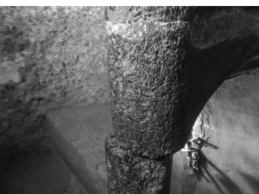
52Preliminary information is given on two sites to show that archaeoseismological research is possible and desirable in Hungary. A Roman road in Savaria (modern Szombathely) shows asymmetric subsidence which may be attributable to seismic activity (Fig. 3): a person or a horse-drawn cart could not move or stand on the 1.5-meter wide tilted edge of the road. This kind of deformation seems a prime example of uneven subsidence caused by seismic-generated liquefaction.
A minor trench or a hand boring might reveal sandy subsoil to corroborate the presence of liquefiable sand. Stairs of the spiral staircase from the fifteenth- century donjon in Nagyvázsony were displaced by roughly 4 cm, obviously caused by lateral loading, possibly due to an earthquake (Fig. 4).
Historical seismology is like a large-resolution snapshot: a single event is documented in great detail. An earthquake which took place in 1202 AD in the Middle East, which was the largest earthquake known to have taken place there, offers an example of a dramatic seismic event which has been thoroughly studied. It was recorded at more than hundred sites within a circle with a radius
51 Morais et al., “Preliminary estimation.”
52 Besharatinezhad et al., “Modelling.”
Figure 4. Displaced steps of the spiral staircase in Nagyvázsony donjon.
A coin with a diameter of 24 mm for scale. #0376
of 500 km.
53Later, the fault responsible was identified in Mount Lebanon.
54The more snapshots we have, the more accurate our hazard assessment.
Archaeoseismology is like a deep borehole: a single site might record successive construction-destruction-reconstruction events over the course of centuries. Although recurrent episodes of damage to the same edifice are not easy to recognize and date, a few promising results are available. For instance, the crusader fortress of Al-Marqab on the coast of Syria,
55the Roman theater in Capitolias (modern Beit-Ras in Jordan),
56and the Byzantine dead city of Umm al-Jimal (also in Jordan) each offer evidence of at least two successive seismic events. While dating is still ambiguous at the Jordanian sites, we find evidence for reconstruction after the first earthquake and abandonment after the second event. Usually, historical sources and archaeoseismology work hand-in-hand, especially when dating is considered.
Summary
Earthquake hazard can be reliably assessed only if we are aware of past seismicity. The relatively small number of seismic events and long return period of major earthquakes make it necessary to use historical data in seismic hazard assessment. However, the lack of documentary data in the central region of the Carpathian-Pannonian region makes this a challenging task. This area practically coincides with the maximum extent of two centuries of Ottoman rule in the sixteenth and seventeenth centuries. An arithmetic assessment suggests that we have no record of 90 percent of the destructive earthquakes which, in all likelihood, occurred in the Carpathian-Pannonian region over the course of the past two millennia.
We suggest that, by using archaeoseismology, we can contribute previously unknown data to this discussion. Damage caused by earthquakes can be recognized, and earthquake parameters can be assessed. Preliminary studies identified previously unknown seismic events (Visegrád) and assigned intensity values to historical records. The damage observed on a Roman road in Savaria and in the medieval donjon of Nagyvázsony offer two examples of the potentials of archaeoseismology. Renewed extensive study of historical sources and the
53 Ambraseys and Melville, “Analysis.”
54 Daeron et al., “Sources.”
55 Kázmér and Major, “Distinguishing damages.”
56 Al-Tawalbeh et al., „Two inferred Antique earthquakes.”
further use of archaeoseismological investigation are needed if we seek to arrive at a nuanced understanding of seismic hazard in the Carpathian-Pannonian region.
Acknowledgements
András Grynaeus called our attention to earthquake damage in the donjon at Nagyvázsony. Two anonymous referees suggested useful improvements.
Thomas Cooper improved English. We are also grateful for their assistance.
Bibliography
Akyüz, H. Serdar, and Erhan Altunel. “Geological and archaeological evidence for post- Roman earthquake surface faulting at Cibyra, SW Turkey.” Geodinamica Acta 14 (2009): 95–101. doi: 10.1016/S0985-3111(00)01057-3.
Al-Tawalbeh, Mohammad, Rasheed Jaradat, Khaleed Al-Bashaireh, Abdullah Al- Rawabdeh, Anne Gharaibeh, Bilal Khrisat, and Miklós Kázmér. „Two inferred Antique earthquakes recorded in the Roman theatre of Beit Ras / Capitolias (Jordan).” Seismological Research Letters, 2020, forthcoming.Ambraseys, Nicholas.
“Archaeoseismology and neocatastrophism.” Seismological Research Letters 76 (2005):
560–64. doi:10.1785/gssrl.76.5.560.
Ambraseys, Nicholas. Earthquakes in the Mediterranean and Middle East: A Multidisciplinary Study of Seismicity up to 1900. Cambridge: Cambridge University Press, 2009.
Ambraseys, Nicholas, and C. P. Melville. “An analysis of the Eastern Mediterranean earthquake of 20 May 1202.” In Historical Seismograms and Earthquakes of the World, edited by Bill Lee, H. Meyers, and K. Shimazaki, 181–200. San Diego: Academic Press, 1988.
Bacchielli, Lidiano. “A Cyrenaica earthquake post 364 A.D.: Written sources and archaeological evidences.” Annali di Geofisica 38 (1995): 977–82.
Bada, Gábor, Frank Horváth, Péter Dövényi, Péter Szafián, Gábor Windhoffer, Sierd Cloetingh. “Present-day stress field and tectonic inversion in the Pannonian basin.” Global ad Planetary Change 58 (2007): 165–80. doi: 10.1016/j.
gloplacha.2007.01.007.
Bahrouni, Nejib, Mustapha Meghraoui, Klaus Hinzen, Mohamed Arfaoui, Faouzi, Mahfoud. “The damaging earthquake of 9 October 859 in Kairouan (Tunisia):
Evidence from historical and archoeseismological investigations.” Seismological Research Letters 98 (2020): 1890–1900. doi: 10.1785/0220190258.
Benjelloun, Yacine, Julia Sigoyer, Hélène Dessales, Stéphane Garambois, and M. Sahin.
“Construction history of the aqueduct of Nicaea (Iznik, NW Turkey) and its on-fault deformation viewed from archaeological and geophysical investigations.” Journal of Archaeological Science: Reports 21 (2018): 389–400. doi: 10.1016/j.jasrep.2018.08.010.
Besharatinezhad, Ali, Ákos Török, Mohammad Al-Tawalbeh, and Miklós Kázmér.
“Modelling of seismicity-induced cracking of stone columns using discrete- element-method (DEM), a case study of Eufrasius cathedral, Porec, Croatia.”
In European Geosciences Union General Assembly, 3–8 May 2020, Vienna, Austria.
EGU2020-10462. doi:10.5194/egusphere-egu2020-10462.
Csukovits, Enikő. “Források, műfajok, lehetőségek: A középkori Magyarország-kép elemei” [Sources, genres, possibilities: Elements of West European image of Hungary]. Korall 38 (2009): 5–29.
Daëron, M., Y. Klinger, P. Tapponnier, A. Elias, E. Jacques, and A. Sursock. “Sources of the large A.D. 1202 and 1759 Near East earthquakes.” Geology 33 (2005): 529–32.
doi: 10.1130/G21352.1.
Decker, Kurt, Georg Gangl, and Manfred Kandler. “The earthquake of Carnuntum in the fourth century A.D.: Archaeological results, seismologic scenario and seismotectonic implications for the Vienna Basin fault, Austria.” Journal of Seismology 10 (2006): 479–95. doi:10.1007/s10950-006-9032-0.
Earthquake Catalogue 2019: Geodetic and Geophysical Institute, Research Centre for Astronomy and Earth Sciences, Hungarian Academy of Sciences, Sopron, Hungary.
Ellenblum, Ronnie, Shmuel Marco, Amotz Agnon, Thomas K. Rockwell, and A. Boas.
“Crusader castle torn apart by earthquake at dawn, 20 May 1202.” Geology 26 (1998):
303–6. doi:10.1130/0091-7613(1998)026<0303:CCTABE>2.3.CO;2.
Evans, Arthur. The palace of Minos. Vol. 1. London: McMillan, 1928.
Galadini, Fabrizio, Klaus-G. Hinzen, and Stathis Stiros. “Archaeoseismology:
methodological issues and procedure.” Journal of Seismology 10 (2006): 395–414.
doi:10.1007/s10950-006-9027-x.
Grossinger, J. B. Dissertatio de terrae motibus Regni Hungariae. Jaurini, 1783.
Guidoboni, Emanuela, and Alberto Comastri. Catalogue of Earthquakes and Tsunamis in the Mediterranean Area from the 11th to the 15th Century. Rome: Instituto nazionale di geofisica e vulcanologia, 2005.
Hammerl, C. and Wolfgang A. Lenhardt. “Erdbeben in Niederösterreich von 1000 bis 2009 n. Chr.” Abhandlungen der Geologichen Bundesanstalt 67 (2013): 3–297.
Hammerl, C., Klaus Loecker, Ilja Steffelbauer, and Ralf Totschnig. “The Carnuntum case: an earthquake catastrophe around 350 A.D.?” In Second European Conference on Earthquake Engineering and Seismology, 25–29 August, Istanbul, 2014, 2.
Hinzen, Klaus-G., Claus Fleischer, Sharon K. Reamer, Stephan Schreiber, S. Schütte, and B. Yerli. “Quantitative methods in archaeoseismology.” Quaternary International 242 (2011): 31–41. doi:10.1016/j.quaint.2010.11.006.
Hinzen, Klaus-G., Stephan Schreiber, Claus Fleischer, Sharon K. Reamer, and Isabel Wiosna. “Archeoseismic study of damage in Roman and medieval structures in the center of Cologne, Germany.” Journal of Seismology 17 (2013): 399–424. doi:10.1007/
s10950-012-9327-2.
Hough, Susa E. Predicting the unpredictable: The tumultuous science of earthquake prediction.
Princeton: Princeton University Press, 2016.
Jeitteles, Heinrich. “Versuch einer Geschichte der Erdbeben in der Karpathen- und Sudeten-Ländern bis zu Ende der achtzehnten Jahrhunderts.” Zeitschrift der Deutschen Geologischen Gesellschaft 12 (1860): 287–349.
Jones, Richard, and Stathis Stiros. “The advent of archaeoseismology in the Mediterranean.” In The Archaeology of Geological Catastrophes. Special Publications 171, edited by W. G. McGuire, D. R. Griffiths, P. L. Hancock, and I. S. Stewart, 25–32. London: Geological Society of London, 2000. doi10.1144/GSL.
SP.2000.171.01.04.
Jusseret, Simon. “Contextualising the birth of Mediterranean Archaeoseismology.”
Antiquity 88 (2014): 964–74. doi:10.1017/S0003598X00050924.
Kandler, Manfred. “Eine Erdbebenkatastrophe in Carnuntum?” Acta Archaeologica Academiae Scientiarum Hungariae 41 (1989): 313–36.
Karakhanian, Arkadi, A. Avagan, and H. Sourouzian. “Archaeoseismological studies at the temple of Amenhotep III, Luxor, Egypt.” In Ancient Earthquakes. Geological Society of America Special Paper 471. Edited by Manuel Sintubin, Ian S. Stewart, Tina M. Niemi, and Erhan Altunel, 199–222. Boulder: Geological Society of America, 2010. doi: 10.1130/SPE471.
Karcz, Isaakov, and Uri Kafri. “Evaluation of supposed archaeoseismic damage in Israel.” Journal of Archaeological Science 5 (1978): 237–53. doi:10.1016/0305- 4403(78)90042-0.
Kázmér, Miklós. “Damage to ancient buildings from earthquakes.” In Encyclopedia of Earthquake Engineering. Edited by M. Beer, I. Kougioumtzoglou, E. Patelli, and I. S.- K. Au. Berlin–Heidelberg: Springer, 2015. doi:10.1007/978-3-642-36197-5_30-1.
Kázmér, Miklós. “Evidence for earthquake damage on St. Michael church in Cluj- Napoca, Romania.” In 6th National Conference on Earthquake Engineering and 2nd National Conference on Earthquake Engineering and Seismology, edited by F. Pavel, M.
Radulian, C. Arion, M. Popa, and A. Aldea, 14–17 June 2017, Bucharest, Romania.
Proceedings, 95–99.
Kázmér, Miklós. “Why seismic hazard is underestimated in Tunisia? An archaeoseismological study.” In 2nd Conference of the Arabian Journal of Geosciences (CAJG), 25–28 November 2019, Sousse, Tunisia. (in press)
Kázmér, Miklós, Balázs Major. “Distinguishing damages of two earthquakes – archeoseismology of a Crusader castle (Al-Marqab citadel, Syria).” In Ancient Earthquakes. Geological Society of America Special Paper 471, edited by Manuel Sintubin, Ian S. Stewart, Tina M. Niemi, and Erhan Altunel, 186–99.
doi:10.1130/2010.2471(16).
Kázmér, Miklós, Balázs Major. “Safita castle and rockfalls in the ‘dead villages’ of coastal Syria: An archaeoseismological study.” Comptes Rendus Geoscience 347 (2015): 181–90.
Kázmér, Miklós, Mohammad Tawalbeh, Gergely Buzás, and József Laszlovszky.
“Tizenhatodik századi földrengéskárok Visegrádon és Budán: Történeti és archeoszeizmológia” [Sixteenth century earthquake damage at Visegrád and Buda: historical and archaeoseismology]. In Magyarhoni Földtani Társulat, Földtani és Geofizikai Vándorgyűlése [Hungarian Geological Society, Annual Assembly of Geology and Geophysics], 3–5 October 2019, Balatonfüred, 50–53.
Konecny, Andreas, Franz Humer, and K. Decker, ed. Das Carnuntiner Erdbeben im Kontext: Akten des III. Internationaler Kolloquiums, 17.–18. Oktober 2013, Hainburg.
Archäologischer Park Carnuntum, Petronell–Carnuntum. 2019.
Korjenkov, A. M. and E. Mazor. “Seismogenic origin of the ancient Avdat Ruins, Negev Desert, Israel.” Natural Hazards 18 (1999): 193–226. doi:10.1023/A:1026488932377.
Kovács, Péter “Die römische Inschriften Ungarns: Supplementum 1. Kutatási beszámoló” [Research report]. Antik Tanulmányok 47 (2003): 319–22.
Lewis, N. N. “Baalbek before and after the earthquake of 1759: the drawings of James Bruce.” Levant 31 (1999): 241–53.
Marco, Shmul. “Recognition of earthquake-related damage in archaeological sites:
Examples from the Dead Sea fault zone.” Tectonophysics 453 (2008): 148–56.
doi:10.1016/j.tecto.2007.04.011.
Meghraoui, M., F. Gomez, R. Sbeinati, J. Van der Woerd, M. Mouty, A. N. Darkal, R.
Darawcheh, F. Hijazi, R. Al-Ghazzi, and M. Barazangi. “Evidence for 830 years of seismic quiescence from palaeoseismology, archaeoseismology, and historical seismicity along the Dead Sea fault in Syria.” Earth and Planetary Science Letters 210 (2003): 35–52.
Morais, Eduardo, László Gergely Vigh, and János Krähling. “Preliminary estimation of the probable magnitude of Komárom 1763 earthquake using fragility functions.”
In 16th World Conference on Earthquake (16WCEE 2017), 9–13 January 2017, Santiago, Chile. Paper No. 4454, 11.
Morais, Eduardo, László Gergely Vigh, and János Krähling. “Cyclic behaviour, dynamic analysis and seismic vulnerability of historical building archetypes in Hungary.”
International Journal of Architectural Heritage, 2019. doi:10.1080/15583058.2019.1690074.
Nasir, Asma, Wolfgang A. Lenhardt, Esther Hintersberger, and Kurt Decker. “Assessing the completeness of historical and instrumental earthquake data in Austria and the surrounding areas.” Austrian Journal of Earth Sciences 106 (2013): 90–102.
Nikonov, A. “On the methodology of archaeoseismic research into historical monuments.” In The Engineering Geology of Ancient Works, Monuments and Historical Sites, Preservation and Protection, edited by I. Marinos, G. Koukis, Rotterdam, 1988, 1315–20.
Reicherter, Klaus, Andreas Schaub, Tomas Fernández-Steeger, Christoph Grützner, and Tanja Kohlberger-Schaub. “Aquisgrani terrae motus factus est (part 2): Evidence for medieval earthquake damage in the Aachen Cathedral (Germany).” Quaternary International 242 (2011): 149–57. doi.org/10.1016/j.quaint.2011.05.006.
Réthly, Antal. A Kárpátmedencék földrengései, 455–1918 [Earthquakes in the Carpathian Basin, 455–1918]. Budapest: Akadémiai Kiadó, 1952.
Rodríguez-Pascua, M., P. G. Silva, R. Pérez-López, J-L. Giner-Robles, F. Martín-González, and M. A. Perucha. “Preliminary intensity correlation between macroseismic scales (ESI07 and EMS98) and Earthquake Archaeological Effects (EAEs).” In Seismic Hazard, Critical facilities and Slow Active Faults, edited by C. Grützner, A. Rudersdorf, R.
Pérez-López, and K. Reicherter. PATA Days. Proceedings of the 4th International INQUA Meeting on Paleoseismology, Active Tectonics and Archaeoseismology (PATA), 9–14 October 2013, Aachen, Germany, 221–24.
F. Romhányi, Beatrix. “A középkori egyházi épületek kutatása – eredmények és feladatok”
[Research into medieval ecclesiastical buildings – findings and tasks.] In A középkor és a kora újkor régészete Magyarországon, edited by Elek Benkő, and Gyöngyi Kovács, 255–70. Budapest: MTA Régészeti Intézet, 2010.
Roumane, Kahina, and Abdelhakim Ayadi. “Archaeoseismology in Algeria: Observed damages related to probable past earthquakes on archaeological remains of Roman sites (Tel Atlas of Algeria).” In The Geology of the Arab World: An Overview, edited by A. Bendaoud et al., 319–39. Bern: Springer Nature, 2019. doi:10.1007/978-3-319- 96794-3_8.
Silva, P. G., F. Borja, C. Zazo, J. L. Goy, T. Bardají, L. De Luque, J. Lario, and C. J. Dabrio.
“Archaeoseismic record at the ancient Roman City of Baelo Claudia (Cadiz, south Spain).” Tectonophysics 408 (2005): 129–46.
Skrgulja, Rosana, and Miklós Kázmér. “Deformed Roman monuments along active faults in NW Croatia: Archaeoseismological studies.” In 17th Symposium of Tectonics,
Structural Geology and Crystalline Geology (TSK 2018), 19–23 March 2018, Jena, Germany.
Abstract volume, 116.
Sternberg, J. v. Versuch einer Geschichte der ungarischen Erdbeben. Abhandlungen der Böhmischen Gesellschaft der Wissenschaften. Prague–Dresden, 1786.
Stiros, Stathis. “Identification of earthquakes from archaeological data: methodology, criteria, and limitations.” In Archaeoseismology. Fitch Laboratory Occasional Paper 7, edited by Stathis Stiros, and Richard E. Jones, 129–52. Athens: British School at Athens, 1996.
Szalay, József. A magyar nemzet története. 3. kötet [History of Hungary, vol. 3]. Baróti, L. and Hatsek, I. Magyarország a török hódoltság korában c. térképe. [Hungary under Ottoman rule, map]. 1897. https://dka.oszk.hu/html/kepoldal/index.
phtml?id=5780 (Last access: 19 March 2020.)
Tari, Edit. Pest megye középkori templomai [Medieval churches in Pest County]. Studia Comitatensia 27. Szentendre, 2000.
Tóth, László, Erzsébet Győri, Péter Mónus, and Tibor Zsíros. “Seismic hazard in the Pannonian region.” In The Adria Microplate: GPS Geodesy, Tectonics and Hazards, edited by Nicholas Pinter, 369–84. Dordrecht: Springer, 2006. doi: 10.1007/1-4020-4235- 3_25.
Vasconcelos, Graça, Paulo B. Lourenço, H. Mouzakis, and L. Karapitta. “Experimental investigations on dry stone masonry walls.” In 1st International Conference on Restoration of Heritage Masonry Structures, 24–27 April 2006, Cairo, Egypt, P31-1–P31-10.
Varga, Péter. “On the magnitude and possible return period of the historical earthquake in ancient Savaria, 455 AD (Szombathely, West Hungary).” Austrian Journal of Earth Sciences 112 (2019): 207–20. doi:10.17738/ajes.2019.0012.
Zolnay, László. “A történeti forrásanyag pusztulása” [Destruction of the historical record]. In Az elátkozott Buda: Buda aranykora [The cursed Buda: Golden year of Buda]. Budapest: Magvető, 1982.
Zsíros, Tibor. A Kárpát-medence szeizmicitása és földrengés veszélyessége: Magyar földrengés katalógus (456–1995) [Sesmisicity and earthquake hazard of the Carpathian Ba- sin: Hungarian Earthquake catalogue, 456–1995]. Budapest: MTA Földtudományi Kutatóközpont Geodéziai és Geofizikai Kutatóintézet Szeizmológiai Obszer- vatórium, 2000.
Zsíros, Tibor. “Earthquake activity and hazard in the Carpathian Basin.” Acta Geodetica Geophysica Hungarica 38 (2003): 345–62. doi: 10.1556/ageod.38.2003.4.8.
Editor-in-Chief
Pál Fodor (Research Centre for the Humanities) Editors
Péter Apor (RCH), Gabriella Erdélyi (RCH), Sándor Horváth (RCH), Judit Klement (RCH), Veronika Novák (Eötvös Loránd University of Budapest), Tamás Pálosfalvi (RCH),
András Vadas (Eötvös Loránd University / CEU), Bálint Varga (RCH) Review Editors
Veronika Eszik (RCH), Judit Gál (Eötvös Loránd University), Janka Kovács (Eötvös Loránd University), Réka Krizmanics (CEU), Tamás Révész (RCH)
Editorial Secretaries
Gábor Demeter (RCH), Judit Lakatos (RCH) Editorial Board
Attila Bárány (University of Debrecen), László Borhi (RCH), Gábor Czoch (Eötvös Loránd University of Budapest), Zoltán Csepregi (Evanglical-Lutheran Theological University), Gábor Gyáni (RCH), Péter Hahner (University of Pécs), György Kövér (Eötvös Loránd University of Budapest), Géza Pálffy (RCH), Attila Pók (RCH), Béla Tomka (University of Szeged), Attila Zsoldos (RCH)
Advisory Board
Gábor Ágoston (Georgetown University), János Bak (Central European University), Neven Budak (University of Zagreb), Václav Bu˚žek (University of South Bohemia), Olivier Chaline (Université de Paris-IV Paris- Sorbonne), Jeroen Duindam (Leiden University), Robert J. W. Evans (University of Oxford), Alice Freifeld (University of Florida), Tatjana Gusarova (Lomonosov Moscow State University), Catherine Horel (Université de Paris I Panthéon-Sorbonne), Olga Khavanova (Russian Academy of Sciences), Gábor Klaniczay (Central European University), Mark Kramer (Harvard University), László Kontler (Central European University), Tünde Lengyelová (Slovakian Academy of Sciences), Martyn Rady (University College London, School of Slavonic and East European Studies), Anton Schindling (Universität Tübingen), Stanislaw A. Sroka (Jagiellonian University), Thomas Winkelbauer (Universität Wien)
INDEXED/ABSTRACTED IN: CEEOL, EBSCO, EPA, JSTOR, MATARKA, Recensio.net.
social sciences and humanities with a focus on Hungarian history. The journal’s geographical scope—Hungary and East-Central Europe—makes it unique: the Hungarian Historical Review explores historical events in Hungary, but also raises broader questions in a transnational context. The articles and book reviews cover topics regarding Hungarian and East-Central European History. The journal aims to stimulate dialogue on Hungarian and East-Central European History in a transnational context. The journal fills lacuna, as it provides a forum for articles and reviews in English on Hungarian and East-Central European history, making Hungarian historiography accessible to the international reading public and part of the larger international scholarly discourse.
The Hungarian Historical Reviews
(Formerly Acta Historica Academiæ Scientiarum Hungaricæ) 4 Tóth Kálmán utca, Budapest H – 1097 Hungary Postal address: H-1453 Budapest, P.O. Box 33. Hungary E-mail: hunghist@btk.mta.hu
Homepage: http: \\www.hunghist.org Published quarterly by the Institute of History, Research Centre for the Humanities (RCH).
Responsible Editor: Pál Fodor (Director General).
Prepress preparation by the Institute of History, RCH, Research Assistance Team;
Leader: Éva Kovács. Page layout: Imre Horváth. Cover design: Gergely Böhm.
Printed in Hungary, by Prime Rate Kft, Budapest.
Translators/proofreaders: Alan Campbell, Matthew W. Caples, Thomas Cooper, Sean Lambert, Thomas Szerecz.
Annual subscriptions: $80/€60 ($100/€75 for institutions), postage excluded.
For Hungarian institutions HUF7900 per year, postage included.
Single copy $25/€20. For Hungarian institutions HUF2000.
Send orders to The Hungarian Historical Review, H-1453 Budapest, P.O. Box 33.
Hungary; e-mail: hunghist@btk.mta.hu
Articles, books for review, and correspondence concerning editorial matters, advertising, or permissions should be sent to The Hungarian Historical Review, Editorial, H-1453 Budapest, P.O. Box 33. Hungary; e-mail: hunghist@btk.mta.
hu. Please consult us if you would like to propose a book for review or a review essay.
Copyright © 2020 The Hungarian Historical Review by the Institute of History, Research Centre for the Humanities.
All rights reserved. No part of this book may be reproduced, stored, transmitted, or disseminated in any form or by any means without prior written permission
ungar ian H istor ical R eview N atur al R esour ces and Society 9/2 | 2020
New Series of Acta Historica Academiæ Scientiarum Hungaricæ
2020
volume number
9 2
Natural Resources and Society
Natural Resources and Society
Contents
Éva Bodovics 179 Sándor Rózsa 213 Beatrix F. Romhányi, Zsolt Pinke,
József Laszlovszky 241 Miklós Kázmér,
Erzsébet Győri 284 András Grynaeus 302 Viktória Kiss 315 Zoltán Czajlik 331 Weather Anomalies and Their Economic Consequences
Evaluation of the Floodplain Farming Environmental Impacts of Medieval Uses of Natural Resources
Millennial Record of Earthquakes
Dendrochronology and Environmental History:
The Difficulties of Interpretation
Transformations of Metal Supply during the Bronze Age Distribution of Stone Raw Materials in the Late Iron Age