Surface geology of Hungary
Explanatory notes to the Geological map of Hungary
(1:500 000)
Edited by:
Zsolt K ERCSMÁR
Written by:
Tamás B
UDAI, Gábor, C
SILLAGZsolt K
ERCSMÁR, Ildikó S
ELMECZI, Orsolya S
ZTANÓBudapest, 2015
Copyright Geological and Geophysical Institute of Hungary 2015 All rights reserved!
Rewier:
Gyula KONRÁD
English text:
Daniella TOLMÁCS
Linguistic reviewer:
Philip RAWLINSON
Technical editor:
Olga PIROS
DTP:
OLGAPIROS
PÉTERKŐBÁNYAI
Published by the Geological and Geophysical Institute of Hungary Responsible editor:
FANCSIKTamás director
Reference:
KERCSMÁR, ZS. (ed.), BUDAI, T., CSILLAG, G., SELMECZI, I., SZTANÓ, O. 2015:
Surface geology of Hungary.
Explanatory notes to the Geological map of Hungary (1:500 000).
— Geological and Geophysical Institute of Hungary, Budapest.
ISBN 978-963-671-302-7
Introduction (Zsolt KERCSMÁR) . . . . Geological build-up of the regions of Hungary (Tamás BUDAI) . . . . Dunántúli-középhegység (Transdanubian Range) . . . . Északi-középhegység (North Hungarian Range) . . . . The Mecsek and the Villány Hills . . . . Dunántúli-dombság (Transdanubian Hills) . . . . Kisalföld (Little Hungarian Plain) and Alpokalja . . . . Alföld (Great Hungarian Plain) . . . . Geological description of the superficial formations of Hungary (Tamás BUDAI– TB, Gábor CSILLAG– GCs, Zsolt KERCSMÁR– ZsK, Ildikó SELMECZI– IS, Orsolya SZTANÓ– OSz) . . . . Palaeozoic (undivided) (TB) . . . . Ordovician–Silurian (TB) . . . . Ordovician–Devonian (TB) . . . . Silurian–Devonian (TB) . . . . Devonian (TB) . . . . Carboniferous (TB) . . . . Permian (TB) . . . . Triassic (TB) . . . . Lower Triassic . . . . Middle Triassic . . . . Middle–Upper Triassic . . . . Upper Triassic . . . . Triassic–Jurassic (TB) . . . . Triassic–Cretaceous (TB) . . . . Jurassic . . . . Lower–Middle Jurassic (TB) . . . . Middle–Upper Jurassic (TB) . . . . Jurassic (undivided) (TB) . . . . Jurassic–Cretaceous (TB) . . . . Cretaceous . . . . Lower Cretaceous (TB) . . . . Lower–Upper Cretaceous (TB) . . . . Upper Cretaceous (TB, ZsK) . . . . Eocene (ZsK) . . . . Eocene–Oligocene (ZsK) . . . . Oligocene (ZsK) . . . . Oligocene–Miocene (IS, ZsK) . . . . Miocene . . . . Lower Miocene (IS) . . . . Lower–Middle Miocene (IS) . . . . Middle Miocene (IS) . . . . Middle–Upper Miocene (IS) . . . . Upper Miocene (GCs, OSz) . . . .
Contents
5 7 7 9 10 11 11 11 12 12 12 13 13 13 14 15 17 17 17 19 20 22 22 23 23 24 25 26 26 26 27 27 28 30 31 33 34 34 38 38 44 45
Miocene–Pliocene (GCs, OSz) . . . . Miocene–Pleistocene (GCs) . . . . Pliocene (GCs) . . . . Pliocene–Pleistocene (GCs) . . . . Pleistocene (GCs) . . . . Pleistocene–Holocene (GCs) . . . . Holocene (GCs) . . . . References . . . . Index . . . . Contributors to the volume . . . .
50 52 52 52 53 55 55 57 63 66
I NTRODUCTION
Geological mapping is the oldest research method for establishing a base for geological knowledge (LYELL1830). The visible and concrete result of this method is a geological map of our wider and narrower environment, complete with an explanatory book; the purpose of the latter is to help with the interpretation. The development of new geological research methods, and the information gathered from these, help towards discovering more aboutthe geological build-up of a particular country — in this case Hungary. Furthermore, it necessitates the compilation of new detailed geological maps which provide an overview of Hungary in accordance with the most up-to-date knowledge and technology available, along with explanatory books helping their interpretation (KERCSMÁRet al. 2015).
The first “classical” geological map depicting the whole Carpathian Basin (and thus, the whole territory of Hungary) was published in Vienna, at the time of the Austro-Hungarian Empire (HAUER1867). It was followed thirty years later (in 1896) by the 1:1,000,000-scale Geological Map of Hungary, which was published by the Hungarian Geological Society and the Hungarian Royal Geological Institute, under the patronage of Andor Semsey (BÖCKHet al. 1896). After another thirty years, in 1922, a new geological map was published of Hungary at a scale of 1:900,000 (LÓCZY, PAPP1922). Later a 1:300,000-scale map was compiled, representing the new area of the country, which lost two-thirds of its territory after WW1 (BALOGHet al. 1956). The latest published geological overview map (1:500,000) of Hungary dates back 30 years (FÜLÖPet al. 1984). However, no explanatory book was made to accompany this map. Since that time our knowledge about the geology of the country has been expanded with (i) the geological mapping of several regions (KORPÁSed. 1998; BUDAI
et al. 1999, GYALOG, HORVÁTHeds 2004, SZENTPÉTERY, LESSeds 2006, PELIKÁN, BUDAIeds 2005, BUDAI, FODOReds 2009) (ii) with stratigraphic and litostratigraphic summaries (GYALOGed. 1996, BÉRCZI, JÁMBOReds 1999, GYALOG, BUDAIeds 2004), and (iii) with comprehensive monographic works (FÜLÖP1990, 1994; HAAS2004).
At the beginning of the 1990s a lithostratigraphy-based uniform legend system of the geological formations of Hungary was established. This was in line with the objectives laid down in the frame of the EOFT project (Egységes Földtani Térképrendszerek = “Unified National Geological Map System”) of the Geological Institute of Hungary (GYALOGed.
1996). Based on this uniform classification, ten years later a 1:100,000-scale digital geological map, was compiled (GYALOG
ed. 2005). On the basis of the 1:100,000-scale map series (containing 88 map sheets), four years later a Geological Atlas of Hungary was published (BUDAI, GYALOGeds 2009). It contained a 1:200,000-scale geological map, compiled on the basis of the map (GYALOG, BUDAIeds 2009).
From these the two maps (the basis of which is a digital database), the newest overview surface geological map (1:500,000) of Hungary was created (with appropriate merging according to the scale) (GYALOG2013). This map was published 30 years after the mapping of FÜLÖPet al. (1984); it depicts the geological formations of Hungary not by their lithological characteristics, but on the basis of their respective lithostratigraphic bases, as approved by the Hungarian Stratigraphic Commission. Lithostratigraphic units older than Pleistocene, as well as Pleistocene and Holocene formations were considered alongside integrated stratigraphic, facies, genetical and distribution information.
According to this, in contrast with former practice, the explanatory book of the map is not limited to the brief description of the lithology and the palaeontology. It contains the description of the lithostratigraphic units according to our current knowledge, revealing also the relationship of one unit to the other. The book is special also from another aspect: experts of the respective geological ages were asked to write the chapters of the explanatory book; however, they did not participate in the compilation of the map. As a consequence, there are some theoretical contradictions in connection with the aggregation and depiction of several formations; these points are explained along with the descriptions of the formations. A typical problem was that some important formations are not shown on the maps due to the small scale used and the aggregations.
These rock units are described in the explanatory book and are marked with a superscript star after the name of the formation (for example Pisznice Limestone*). The authors of the explanatory book put the most recent stratigraphic results in the descriptions. These results, however, were changing even during the time of the writing and compilation of the book. At the right place, mostly due to the stratigraphic modifications affecting the Miocene chapters (for example at the beginning of
chapter Upper Miocene), a brief description of the changes is attached to the given stratigraphic units. Where the new results have not been published yet, but have been already approved by the stratigraphic working groups, we refer to them with
“personal communication”.
The surface geological explanatory book is related to the explanatory book “Geology of the pre-Cenozoic basement of Hungary”, published at the end of 2014 (HAAS, BUDAIeds 2014). As a consequence, the description of the surface pre- Cenozic formations is less detailed than that of the Cenozoic formations. A detailed description of the pre-Cenozoic units and the interpretation of the relationships are found in the work of HAAS, BUDAIed. (2014).
The two new explanatory books made for the newest, 1:500,000-scale geological maps are the most complete and most recent summaries of the geology of Hungary. Their combined use provides fresh and concise geological information on the geology of Hungary.
DUNÁNTÚLI-KÖZÉPHEGYSÉG (TRANSDANUBIAN RANGE)
The SW–NE-striking ridge of the Transdanubian Range stretches from the Keszthely Mountains up tothe Pilis–Visegrád Mountains (Figure 1). It is dominantly made up of Triassic formations (Figure 2), the total thickness of which reaches 3 kilometres. Older, Palaeozoic formations crop out from below the Triassic successions in the area of the Balaton Highlands, and the Balatonfő and Velence Mountains. Younger, Mesozoic (Jurassic and Cretaceous) formations cover larger areas in the upland regions of the Bakony and the Gerecse.
The Keszthely Mountainsrise at the south-western end of the Transdanubian Range and are made up of Upper Triassic shallow marine dolomite and limestone. Basaltic mezas occur in the Zalaszántó–Várvölgy Basin (in the northern foreland of the mountains) and in the Tapolca Basin. These remnant hills rise from the loose, Miocene sediments of their surroundings.
The Bakonyregion forms the south-western part of the Transdanubian Range. It has a prolonged (in a NE–SW direction) bowl-shaped (syncline) structure made up of Palaeozoic and Mesozoic rocks, the south-eastern limb of which crops out in
G EOLOGICAL BUILD - UP OF THE REGIONS OF H UNGARY
Figure 1.Map of the regions of Hungary
the area of the Balaton Highlands. In the axis of the syncline Jurassic and Cretaceous formations are deposited. The Palaeogene and Miocene sediments cover large areas in the inter-mountain basins and on the Little Plain, which is the foreland of the mountains.
The Carboniferous granite, which forms part of the crystalline basement of the Transdanubian Range, crops out in the Velence Mountains. The granite is enfolded by older Palaeozoic metamorphic rocks. The northeastern part of the mountains is made up of Eocene andesite.
The northeastern ridge of the Transdanubian Range comprises the Vértes, the Gerecse, the Buda Hills, the Pilis and the Visegrád Mountains. The Vértes Mountains, which are primarily made up of Upper Triassic dolomite, are separated from the Bakony by the Mór Trench. Its northern foreland is covered with Palaeogene (Eocene and Oligocene) sediments, while those in its southern foreland are Upper Miocene (Pannonian). The main mass of the Gerecse is made up of Triassic shallow marine limestone, while the younger Mesozoic (Jurassic–Cretaceous) formations are dominantly known to occur in the northern part of the mountains. Thicker Palaeogene formations occur on the area of the Tatabánya and the Dorog Basins, which represent the southern and eastern forelands of the mountains. The bulk of the Buda and the Pilis Mountainsis made up of Upper Triassic shallow marine dolomite and limestone. In the Buda Hills the Upper Eocene and the Oligocene formations cover larger areas, while the occurrence of the Miocene sediments is restricted to the forelands of the mountains.
The Visegrád Mountainsis situated at the northeastern ending of the Transdanubian Range. In a geological sense, it already belongs to the Miocene volcanic arc of the North Hungarian Range.
Figure 2. Precenozoic on the surface in the Transdanubian Range (after HAAS, BUDAI
eds 2014 modified)
Legend: 3P — Balatonfelvidék Sandstone, 20T
— Köveskál Dolomite, Arács Marl, Hidegkút, Csopak Fm, 17T — Aszófő Dolomite, Iszka- hegy Limestone, 16T — Megyehegy Dolomite, Tagyon Fm, 12T — Felsőörs Limestone, Vászoly Fm, Buchenstein Fm, Füred Limestone, 11T — Budaörs Dolomite, 5T — Veszprém Marl, Csákberény Fm, Sándorhegy Fm, 4T — Sédvölgy Dolomite, Gémhegy Dolomite, Ederics Limestone, Main Dolomite, 3Ta — Rezi Dolomite, 3Tb — Kössen Fm, 2T — Dachstein Limestone, 1T — Mátyáshegy Fm, Csővár Limestone, 6Ja — Kardosrét Lime- stone, 6Jb — Pisznice, Isztimér, Kishát, Törökbükk Limestone, 6Jc — Hierlatz Lime- stone, 6Jd — "ammonitico rosso", Tűzköves- árok Limestone, Kisgerecse Marl, Tölgyhát Limestone, 2Ja — Lókút Radiolarite, 2Jb — Pálihálás Limestone, 2Jc — Szentivánhegy Limestone, 2Jd — Mogyorósdomb Limestone, 8Ka — Bersek Marl, 8Kb — Lábatlan Sandstone, 7Ka — Tata Limestone, 7Kb — Zirc Limestone, Környe Limestone, 6Ka — Tés Clay Marl, 6Kb — Vértessomló Siltstone, Pénzeskút Marl, 4K — Csehbánya Fm, Ajka Fm., 3K — Ugod Limestone, 2K — Jákó, Polány Marl
ÉSZAKI-KÖZÉPHEGYSÉG (NORTH HUNGARIAN RANGE)
The western part of the Miocene volcanic arc of the North Hungarian Range is represented by the Börzsöny Mountains, the geology of which is similar to that of the Visegrád Mountains; the latter are separated from the former by the Danube.
The geology of the two mountain regions is characterised by the alternation of Middle Miocene andesite and dacite lava rocks and pyroclastic rocks (agglomerate, tuff). The middle section of the Miocene andesite volcanic arc is represented by the Cserhát Hillsand the Mátra Mountainsto which, in the north, the basalt area of the Karancs–Medvesupland region joins. The Miocene andesite and the Pliocene basalt overlie (and penetrate) the older (Oligocene and Miocene) clastic sedimentary formations.
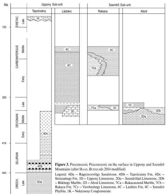
The block of the Bükk Mountainswedges into the Miocene volcanic wreath of the North Hungarian Range. It is made up of sedimentary rocks. The oldest, Palaeozoic formations crop out in the northern part of the Bükk (North Bükk Anticline) and north of it, in the Uppony Mountains (Figure 3). Most parts of the Bükk Plateau are made up of thick Middle–Upper Triassic shallow marine carbonates, which alternate with deep marine sediments in the south-eastern part of the Bükk. The south-western part of the Bükk region is dominantly made up of Jurassic deep marine clastic sediments and magmatic rocks (Figure 4). During the Cretaceous– Palaeocene the rock mass making up the region was intensively folded and foliated. As a result of the uplift, the area was affected by significant denudation. Palaeogene marine sediments occur on the south- western margin of the mountains. The southern foreland of the mountains (Bükkalja– Bükk foothills) is mostly covered with Miocene volcanic rocks, with shallow marine sediments overlying them. The Bükk and the Mátra regions are bordered by Miocene sediment-filled basins in the north (Borsod Basin and Nógrád Basin).
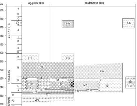
The Aggtelek Karstand the Rudabánya Mountainsare situated in the north-eastern part of the North Hungarian Range.
They are mostly made up of Mesozoic sedimentary rocks and have a rather complicated structure (Figure 5). The Szendrő
Figure 3. Precenozoic Precenozoic on the surface in Uppony and Szendrő Mountains (after HAAS, BUDAIeds 2014 modified)
Legend: 4Da — Rágyincsvölgy Sandstone, 4Db — Tapolcsány Fm, 4Dc — Strázsahegy Fm, 3D — Uppony Limestone, 2Da — Szendrőlád Limestone, 2Db
— Bükhegy Marble, 1D — Abod Limestone, 7Ca — Rakacaszend Marble, 7Cb — Rakaca Fm, 7Cc — Verebeshegy Limestone, 6C — Lázbérc Fm, 4C — Szendrő Phyllite, 1K — Nekézseny Conglomerate
Mountains, which belongs to the Cserehát, are made up of slightly metamorphic Palaeozoic sedimentary rocks. The forelands of the mountains are covered with young, Miocene (Pannonian) clastic sediments.
The Tokaj Mountainsrepresent the north-eastern part of the Miocene volcanic arc of the North Hungarian Range.
This range is made up of Middle and Upper Miocene rhyolite, andesite and dacite. It is bordered by the Hernád River in the west, and by the valley of the River Bodrog in the east.
THE MECSEK AND THE VILLÁNY HILLS The two inselbergs of the South Transdanubian region are the Mecsek and the Villány Hills (Figure 6). The oldest surface formations of the Mecsek(Palaeozoic metamorphic rocks, Carboniferous granite) are known to occur in the eastern part of the mountains, in the area of the Geresd Hills.
Figure 4.P Precenozoic on the surface in the Bükk Mountain (after HAAS, BUDAIeds 2014 modified)
Legend: 4C — Szilvásvárad Fm, 3C — Mályinka Fm, 4Pa — Szentlélek Fm, 4Pb
— Nagyvisnyó Limestone, 20T — Gerennavár Limestone, 16T — Hámor Dolomite, 15Ta — Szentistvánhegy Metaandesite, 15Tb — Várhegy Fm, 11T — Berva, Fehérkői, Bükkfennsík, Kisfennsík Limestone, 8T — Létrás and Szinva Metabasalt, 7T — Hegyestető Fm, Felsőtárkány Limestone, 4Ja — Bányahegy Radiolarite, 4Jb — Lökvölgy Fm
Figure 5. Precenozoic on the surface in the Aggtelek and Rudabánya Hills (after HAAS, BUDAIeds 2014 modified)
Legend: 2Pa — Hídvégardó Complex, Perkupa Anhidrite, 2Pb — Bódvavölgy Ofiolite, 20T — Bódvaszilas Sandstone, Szin Marl, Szinpetri Limestone, 17T — Gutenstein Fm, Rudabánya iron ore-bearing beds , 16T
— Steinalm Limestone, 14T — Szentjánoshegy Limestone, 12T — Dunnatető Limestone, Bódvarákó Fm, Bódvalenke Limestone, Szárhegy Radiolarite, Reifling, Derenk, Nádaska Limestone, 11T — Wetterstein Limestone, 9T — Tornaszentandrás Slate, 7Ta — Hallstatt, Pötschen, Nagykő Limestone, 7Tb — Zlambach Marl, 8Ja — Telekesvölgy Complex, 8Jb — Telekesoldal Complex
The western part of this mountain area is a large anticline (West Mecsek Anticline), composed of thick Permian – Lower Triassic clastic sedimentary rocks, Middle Triassic carbonates, as well as Upper Triassic clastic rocks.
In contrast with this, the bowl-shaped structure of the eastern part of the Mecsek is dominantly built up of Jurassic clastic and carbonatic sedimentary rocks, and Lower Cretaceous volcanic rocks (East Mecsek Syncline); this is the same as the northern structure of the mountains (known as the “Northern Sliver”). In the middle part of the mountain, Lower Miocene andesite can be found, while in the northern foreland Miocene sediments have significant surface occurrences. The structure of the Villány Mountainsis made up of a series of slivers, which have shifted one onto the other. In this rock series Middle and Upper Triassic, Jurassic and Lower Cretaceous carbonate successions are repeated. The surroundings of the two mountains are covered with Quaternary sediments.
DUNÁNTÚLI-DOMBSÁG (TRANSDANUBIAN HILLS)
The Transdanubian Hills comprises the Somogy Hills south of Lake Balaton, and west of it, the Zala Hills. In both areas Late Miocene (Pannonian) sediments represent the oldest surface formations and these are covered with large areas of loess. The characteristic formation of the area between the two hilly regions is the fluvioeolian sand.
KISALFÖLD (LITTLE HUNGARIAN PLAIN) AND ALPOKALJA The bulk of the Little Hungarian Plainis covered with the fluvial sediments of the River Danube and the River Rába. The thickness of these sediments is locally significant (several hundreds of metres). The area is bordered by the Alpokalja region in the west and the Transdanubian Range in the south-east. At the foot of the hills mostly Upper Miocene (Pannonian) clastic sediments occur. Along the margin of the Little Plain, at the foot of the Bakony, several smaller basalt bodies can be found.
The foothills of the Eastern Alps in Hungary are built up of nappes. These foothills are represented by metamorphic rocks which crop out along the western border, in the area of the Alpokalja. The Sopron Mountains are made up of gneiss and mica schist, while the Kőszeg Mountains consist of Jurassic–Cretaceous metamorphic rocks. The crystalline rocks are enclosed by young, Miocene and Quaternary sediments which can be found in the forelands of the mountains.
ALFÖLD (GREAT HUNGARIAN PLAIN)
Most parts of the Great Hungarian Plainare covered with Quaternary, loose, clastic sediments. The Pleistocene succession is dominantly made up of fluvial sediments, which are composed of cyclically alternating gravel, sand, silt and clay.
The thickness of the succession varies in the different parts of the Great Hungarian Plain; for example, in the Jászság Basin, its thickness is 400m (in the Makó Trench) but it may attain 1200m in other areas. The Upper Pleistocene loess is primarily characteristic on the mountain margins of the basins of the Great Hungarian Plain and on the Mezőföld, while the Upper Pleistocene – Holocene wind-blown sand mostly occurs in the Danube–Tisza Interfluve (Kiskunság) and in the Nyírség. Holocene sediments are represented by the floodplain sediments of the rivers and the characteristic formations of alkaline areas.
Figure 6.Precenozoic on the surface in the Mecsek and Villány Mountains (after HAAS, BUDAIeds. 2014 modified)
Legend: 3Pz — Ófalu Group, 5C — Mórágy Granite, 8P — Korpád Sandstone, Kásó Fm, 7P — Gyűrűfű Rhyolite, 6 P — Cserd Fm, 5P — Boda Claystone, 1P — Kővágószőlős Sandstone, 19T — Jakabhegy Sandstone, 18T
— Patacs Siltstone, 17T — Hetvehely Fm, Víganvár Limestone, Rókahegy Dolomite, Lapisi Limestone, 16T — Csukma Fm, Templomhegy Dolomite,13T — Kantavár Fm, 12T — Zuhánya Limestone, 10T — Mészhegy Fm, 6T — Karolinavölgy Sand- stone, 9J — Mecsek Coal, 6J — Vasas Marl, Hosszúhetény Calcareous Marl, Mecsek- nádasd Sandstone, Kecskehát Limestone, Rékavölgy Siltstone, Komló Calcareous Marl, 2Je — Óbánya, Fonyászó, Kisújbánya, Márévár Limestone, 2Jf — Somssichhegy Limestone, 2Jg — Villány Limestone, 2Jh — Szársomlyó Limestone, 10K — Mecsekjánosi Basalt, 9Ka — Magyaregregy Conglomerate, 9Kb — Hidasivölgy Marl, Apátvarasd Limestone, 7K — Nagyharsány Limestone
PALAEOZOIC (UNDIVIDED)
Mica schist, gneiss, amphibolite (Vilyvitány Mica Schist — 4Pz)
Metamorphites occurring in the northern part of the Tokaj Mountains (Tokaji-hegység) include medium- and high- grade disthene, staurolite and sillimanite mica schists, and paragneisses. One can also observe amphibolite intercalations (FÜLÖP 1994). Locally the rocks show signs of mylonitization; the bulk of these rocks have undergone high-grade kaolinization, sericitization and sideritization. Their thickness is unknown. The radiometric age, 312 Ma, marks the time period of the metamorphism.
Gneiss, quartz phyllite, crystalline limestone, serpentinite, amphibolite (Ófalu Group — 3Pz)
The tectonic zone of the Mecsekalja Belt is situated south and east of the Mecsek Mountains and is made up of metamorphised tectonic mega-breccia; in the latter phyllite, amphibolite, serpentinite and gneiss, as well as crystalline limestone and metasandstone occur (FÜLÖP1994, BALLA, GYALOGeds 2009). The rock body has a tectonic contact with the Mórágy Granite, as well as with the Lower Jurassic series of the East Mecsek.
Gneiss; metagranite, amphibolite (Sopronbánfalva Gneiss, Fertőrákos Crystalline Schist, Gödölyebérc Amphibolite — 2Pz)
Foliated gneiss (biotite-muscovite gneiss) can be found in the crystalline schist series of the Soproni-hegység (Sopron Mountains). This formed as a result of the alteration of the granite body that was injected into the Palaeozoic sedimentary rock succession (Sopronbánfalva Gneiss). The quantity of the amphibolite and the leucophyllite (quartz–muscovite schist) is less; they occur as lenses or are bound to certain horizons. Probably, their original material was basic volcanic rock (Gödölyebérc Amphibolite) (FÜLÖP1990, LELKESNÉFELVÁRI1998). The outcropping metamorphites in the vicinity of Fertőrákos are amphibolite schists, mica schists and gneisses (Fertőrákos Crystalline Schist). The first metamorphic event took place 280–300 million years ago. It was followed by another, ca. 70–80 million years ago (Alpine Orogenesis).
Mica schist, amphibole schist, muscovite schist, phyllite, leucophyllite, quartz schist (Óbrennberg, Vöröshíd Mica Schist, Füzesárok White Schist — 1Pz)
The largest part of the mass of the Sopron Mountains is made up of polymetamorphic mica schists. The protoliths of these schists were sedimentary rocks that were affected by metamorphism during the Variscan orogeny, ca. 280-300 million years ago (FÜLÖP1990, LELKESNÉFELVÁRI1998).
ORDOVICIAN–SILURIAN
Quartz phyllite, chlorite–muscovite schist; gneiss (Balatonfőkajár Quartz Phyllite — OS)
A greenschist facies rock body crops out on the area of Balatonfő. It comprises grey, greenish grey quartz phyllite, quartzite and chlorite–muscovite schist, accompanied by carbonate-quartz phyllite, albite gneiss and graphitic schist. It is highly foliated.
G EOLOGICAL DESCRIPTION OF THE SUPERFICIAL
FORMATIONS OF H UNGARY
According to borehole data, its thickness reaches hundreds of metres. There is no information on its age, but on the basis of lithostratigraphic estimates it can be assigned to the Ordovician–Silurian (FÜLÖP1990, LELKESNÉFELVÁRI1998, BUDAIet al. 1999).
ORDOVICIAN–DEVONIAN
Slate, metasiltstone, metasandstone (Lovas Slate — OD)
The largest part of the Early Palaeozoic succession of the Transdanubian Mountains is made up of an anchimetamorphic rock series comprising grey, greenish grey slate, metasiltstone and metasandstone, as well as siliceous shale lenses (Lovas Slate). In several horizons the intercalations of acidic (Alsóörs Metarhyolite*), basic (Litér Metabasalt*), and neutral metavolcanic (Révfülöp Metaandesite*) bodies can be seen. In most cases the rock series is highly folded (sometimes, overturned). The substratum is unknown. The overlying formation is Upper Permian sandstone; this has been deposited with a significant hiatus and erosional unconformity. The maximal as-drilled-thickness of the formation exceeds 1000m. It occurs on the surface in the Balaton Highland (Révfülöp, Alsóörs) and in the northern part of the Velence Mountains (Pátka, Szűzvár, Nadap). According to the fossil records (acritarchs, graptolites, conodonts), its age is Ordovician–Devonian (FÜLÖP1990, LELKESNÉFELVÁRI1998, BUDAIet al. 1999, GYALOG, HORVÁTHeds 2004).
SILURIAN–DEVONIAN
Microgabbro, metabasalt (Bencehegy Microgabbro — SD)
Adark greenish grey, basic, holocrystalline, ophitic-textured subvolcanic dyke is known to occur only in the eastern part of the Velence Mountains. Its major mineral constituents are basic plagioclase, monoclinic pyroxene, green amphibole and magnetite. It is deposited in the upper part of the Lovas Slate and can be assigned to the Silurian–Devonian (GYALOG, HORVÁTHeds 2004).
DEVONIAN
Shallow-marine sandstone, metasiltstone, open-marine shale, siliceous shale, basic metavolcanics (Csernelyvölgy, Rágyincsvölgy Sandstone, Tapolcsány, Strázsahegy Fm — 4D)
The lower section of the Early Palaeozoic succession of the Uppony Mountains is represented by fine-grained, foliated metasandstone (Figure 3, 4Da). It is made up of quartz grains and cemented by silica (Rágyincsvölgy Sandstone). It is accompanied by shale intercalations. It passes upward into massive or thick-bedded, silica-cemented, hard sandstone (greywacke); the latter contains shale, sandstone and phyllite clasts (Csernelyvölgy Sandstone). The thickness of the sandstone succession ranges between 100 and 200m. Given that it does not contain any fossils, it can be assigned to the Upper Ordovician solely on the basis of stratigraphic analogies (FÜLÖP1994, KOVÁCS1998, PELIKÁNet al. 2005). Above the sandstone, deep marine turbidite follows, and this is composed of alternating dark grey shale and thinly-bedded siliceous shale (radiolarite). Locally, the formation contains basic volcanic (metabasalt) intercalations (Tapolcsány Fm, Figure 3, 4Db). It thickness can attain 400m. Due to the absence of horizon-marking fossils, it is assigned to the Silurian solely on the basis of stratigraphic analogies. The upper section of the Early Palaeozoic succession is made up of metabasalt, light grey, crinoidal limestone and metasomatic (ankeritic-sideritic) carbonate rocks (Strázsahegy Fm, Figure 3, 4Dc); olistostrome horizons can also be found in these rocks. According to conodonts, the age of the formation is Middle–Late Devonian (FÜLÖP 1994, KOVÁCS1998, PELIKÁNet al. 2005).
Shallow-marine crystalline limestone (Polgárdi, Uppony Limestone — 3D)
In the Balatonfő region, shallow marine, platform, dominantly thick-bedded, cyclic, white, crystalline limestone crops out (Polgárdi Limestone). The known maximum thickness of the formation exceeds 300m (borehole Szabadbattyán Szb–5).
Its stratigraphic position is tectonic; the overlying formation is unknown and its assumed age is Middle Devonian, on the basis of badly preserved Stromatoporoideafossils (FÜLÖP1990, HORVÁTHet al. 2004).
Light grey, unbedded or thick-bedded, shallow marine (platform) crystalline limestone is known to occur in the north- western part of the Uppony Mountains (Uppony Limestone,Figure 3). Its thickness is around 200m. In the absence of
fossils, only stratigraphic analogies can help to determine the age of the formation, which is reckoned to be Middle–Upper Devonian (FÜLÖP1994, KOVÁCS1998, PELIKÁNet al. 2005).
Marble, crystalline limestone, phyllite–metasandstone (Bükhegy Marble, Szendrőlád Limestone — 2D)
The most extensive formation of the Szendrő Mountains comprises coarse-crystalline marble (bioherm facies) and the basin facies of fine-crystalline limestone, and phyllite–metasandstone (Szendrőlád Limestone, Figure 3, 2Da). According to conodonts, the age of the formation is Middle–Late Devonian. Its thickness is around 400m. The Szendrőlád Limestone is overlain by bedded or massive, coarse-crystalline marble of carbonate platform facies (Bükhegy Marble, Figure 3, 2Db).
The age of the formation is Middle–Late Devonian. Its thickness is ca. 200m (FÜLÖP1994, KOVÁCS1998).
Marine metatuffitic limestone (Abod Limestone — 1D)
Deposited onto the Devonian platform carbonate of the Uppony Mountains, greenish grey, thinly-bedded, pelagic basin limestone can be found. It contains chloritized basic metatuffite (cippolino), as well as black shale and metabasalt intercalations, and it has transverse foliation (Figure 3). Its thickness is around 200m. According to the rich condont fauna, its age is Late Devonian (FÜLÖP1994, KOVÁCS1998, PELIKÁNet al. 2005).
CARBONIFEROUS
Shallow-marine marble, sericitic limestone (Rakaca Fm, Verebeshegy Limestone — 7C)
The Upper Devonian carbonate platform succession of the Szendrő Mountains comprises white and bluish grey, banded, bedded or massive coarse-crystalline marble (Rakacaszend Marble*) (FÜLÖP1994, KOVÁCS1998) (Figure 3, 7Ca). Its thickness is around 200m. The Lower–Middle Carboniferous marble (Rakaca Fm, Figure 3, 7Cb) has a similar facies. It interfingers with dark grey, fine-crystalline, conodont-bearing basin limestone (Verebeshegy Limestone, Figure 3, 7Cc).
Weakly metamorphosed limestone, fine-grained sandy siltstone; shale (Zobóhegyese, Lázbérc Fm — 6C) The lowermost section of the Upper Carboniferous succession of the Bükk Mountains (in the north-east of Hungary) is made up of alternating black, clayey and fine sandy siltstone, and bedded–thick bedded grey sandstone (Zobóhegyese Fm).
Into the latter 10–40m thick dark grey limestone bodies have been deposited. In certain horizons the sandstone is coarse- grained and silicified. The formation occurs only in the north-western part of the Bükk. In the north, it is connected to the Mályinka Formation along a steep tectonic plane. It is overlain by the Szilvásvárad Formation. Its thickness is estimated to be 600m. In the absence of fossils, it can be assigned to the lowermost part of the Upper Carboniferous solely on the basis of stratigraphic analogies (FÜLÖP1994, PELIKÁNet al. 2005).
The Upper Carboniferous succession of the Uppony Mountains is made up of alternating dark grey, thin- bedded–bedded, recrystallised, pelagic basin limestone and grey shale (Lázbérc Fm, Figure 3). The thickness of the formation ranges between 200 and 300m. According to its rich conodont fauna record, it can be assigned to the lowermost Upper Carboniferous (FÜLÖP1994, KOVÁCS1998, PELIKÁNet al. 2005).
Weakly metamorphosed monzogranite, monzonite (Mórágy Granite — 5C)
The Mórágy Block (Geresd Hills) belongs to the East Mecsek mountain area. Its main mass is made up of monzogranite, accompanied by monzonite inclusions and leucocratic dyke rocks (Figure 6). The magmatic body, that locally shows signs of foliation, was affected by metamorphic effects of varying intensity. A smaller outcrop of the formation is known in the western part of the Mecsek, at Nyugotszenterzsébet. According to recent studies, the K-Ar radiometric age (~310–320 Ma) marks the time of the metamorphic event; magma injection occurred ca. 340–350 million years ago (FÜLÖP1990, BALLA, GYALOGeds 2009).
Deep-marine sandstone, siltstone, clay, phyllite (Szilvásvárad Fm, Szendrő Phyllite — 4C)
The Variscan flysch, which outcropsin the area of the Szendrő Mountains, is made up of dark grey, black phyllite. In the latter there are also graded sandstone, metasandstone, limestone olistostrome and allodapic limestone horizons (Szendrő Phyllite). The material of the olistostromes has its main derivation from the Verebeshegy Limestone and the Rakaca Marble.
According to the conodont fauna record, the formation can be assigned to the Upper Carboniferous (lower section). The thickness varies between 500 and 600m (FÜLÖP1994, KOVÁCS1998, PELIKÁNet al. 2005).
A dark grey, black turbiditic rock series made up of cyclic sandstone, siltstone and clay crops out in the area of the anticline in the north-western part of the Bükk. It also contains small-grained polymict conglomerate and pebbly sandstone intercalations (Szilvásvárad Fm, Figure 4). As a result of anchizone metamorphism it has a foliated structure. Its thickness can exceed 1000m. It is overlain by the Mályinka Formation. According to stratigraphic analogies it can be assigned to the lower section of the Upper Carboniferous (FÜLÖP1994, PELIKÁNet al. 2005).
Shallow-marine sandstone, siltstone, claystone (Mályinka Fm — 3C)
AVariscan molasse outcrops in the north-western part of the Bükk and in the Uppony Mountains (Figure 4). It is made up of a shallow marine clastic series, comprising alternating dark grey sandstone, siltstone and clay beds In this succession there are also conglomerate lenses and limestone bodies; the latter are represented by a diverse shallow marine fossil assemblage (algae, corals, crinoids and large foraminifera). The succession is foliated as a result of anchizone metamorphism. Its maximal thickness is 400m. It is assigned to the middle section of the Upper Carboniferous (FÜLÖP1994, KOVÁCS1998, PELIKÁNet al. 2005).
Biotitic orthoclase granite; microgranite, granite porphyry, aplite (Velence Granite — 2C)
In the Transdanubian Mountains, the granite crops out in the area of the Velence mountain range (Figure 2). The calc- alkalic granite was consolidated at a hypabyssal depth. It contains pegmatite bodies, as well as microgranite and granite porphyry dykes. Its thickness is unknown; it is an intrusion in the Early Palaeozoic schist mantle. The radiometric age of the intrusion ranges between 260 and 320 Ma (according to recent measurements); the process of intrusion was also taking place in the Early Permian (274–282 Ma) (GYALOG, HORVÁTHeds 2004).
Fluvial conglomerate, sandstone, siltstone, claystone (Füle Conglomerate — 1C)
The Variscan molasse facies of the Transdanubian Mountains is represented by a cyclic rock series in the Balatonfő region.
This region consists of alternating grey conglomerate, sandstone and siltstone beds The bulk of the material of the grains is quartzite and quartzphyllite, as well as (rarely) metasandstone, metasiltstone, sericite schist and metarhyolite. Grey, dark grey, well-bedded clay and siltstone form thin intercalations in the formation. These intercalations have high organic carbon content and often contain carbonized plant fragments (Calamites) and coal bands. The stratigraphic position of the formation is unknown;
according to the plant fragments and sporomorphs, its age is Late Carboniferous (FÜLÖP1990, MAJOROS1998, BUDAIet al. 1999).
PERMIAN
Fluvial conglomerate, sandstone, siltstone, clay (Korpád Sandstone, Kásó Fm — 8P)
In the west of the Mecsek Mountains the superficial occurrence of the Lower Permian fluvial clastic succession (molasse) is restricted to a smaller area. The succession is made up of fining-upward cycles of red conglomerate, sandstone and siltstone (Korpád Sandstone, Figure 6). The formation has been exposed by several boreholes in the area of the Villány Mountains and from an area between the Mecsek and the Villány Mountains. Its thickness is 100–700m. Its Early Permian age is justified by palynomorphs (FÜLÖP1994, BARABÁS, BARABÁSNÉSTUHL1998).
In the vicinity of Felsőregmec, in the northern part of the Tokaj Mountains, fluvial, greenish grey, grey and red sandstone, foliated siltstone, and small-pebbled conglomerates (Kásó Fm) occur; these are accompanied by rhyolite and rhyolitic tuff (7P–Gyűrűfű Rhyolite) intercalations (FÜLÖP1994, JÁMBOR1998).
Rhyolite, rhyolitic pyroclastic rock, tuffite (Gyűrűfű Rhyolite — 7P)
In the western foreland of the Mecsek, the Lower Permian rhyolite crops out over a small area. The rock is made up of brown, reddish brown, greyish lilac and green extrusive and subvolcanic lava rocks, accompanied locally by tuff and agglomerate intercalations (Figure 6). The formation frequently contains xenoliths of basement origin (metamorphite, Carboniferous and Permian sandstone). According to borehole data, from between the Mecsek and the Villány Mountains, the maximal known thickness of the formation is 830m. Its age is justified by radiometric data (FÜLÖP1994, BARABÁS, BARABÁSNÉSTUHL1998).
Fluvial sandstone, conglomerate, siltstone (Cserdi Fm — 6P)
The Middle Permian succession of the western foreland of the Mecsek is represented by cyclically alternating fluvial and fanglomerate-type conglomerate, and coarse-grained reddish brown sandstone (Figure 6). The material of the pebbles is mostly rhyolite and, albeit less frequently, granite or metamorphic rock. The maximum hickness of the drillings is around 1000m (FÜLÖP1994, BARABÁS, BARABÁSNÉSTUHL1998). The formation is denuded west of the Mecsek and it is known to occur at the southern boundary, in the Máriakéménd–Bár ridge.
Lacustrine claystone, siltstone (Boda Claystone — 5P)
The Middle Permian succession of the West Mecsek comprises playa lacustrine reddish brown siltstone, argillite and dolomite marl (Figure 6). There are also sandstone beds in the lower section of the formation. Its maximal thickness is around 1000m. Its extent is unknown; in the east it interfingers with the Cserdi Formation, as shown by the ore exploratory drillings near the city of Pécs. Its accepted age is justified by palynomorphs (FÜLÖP1994, BARABÁS, BARABÁSNÉSTUHL1998).
Shallow-marine limestone; sandstone, siltstone, evaporite (Nagyvisnyó Limestone, Szentlélek Fm — 4P)
The lower, ca. 100–300 m-thick section of the Upper Permian succession of the Bükk is made up of green, red, lilac- patched sandstone and siltstone. This succession is overlain by a 120–150 m-thick sabkha succession of alternating claystone, dolomite and gypsum–anhydrite (Szentlélek Fm, Figure 4, 4Pa). The uppermost part of the Upper Permian succession of the Bükk comprises thinly-bedded, black limestone, which also contains marl and calcareous marl intercalations. Frequently, in the lower section of the formation, dolomitized bodies occur (Nagyvisnyó Limestone, Figure 4, 4Pb). The formation was formed in an isolated lagoon. It occurs in the area of the North Bükk Anticline. It is highly pressed and is intersected with a dense calcite vein network. It has rich micro- and macrofauna, as well as microflora assemblages; according to the presence of this evidence its age is Late Permian. Its thickness is 300m (FÜLÖP
1994, PELIKÁNet al. 2005).
Fluvial sandstone, siltstone, conglomerate (Balatonfelvidék Sandstone — 3P)
The overwhelming part of the Upper Permian succession of the Transdanubian Mountains is a red, terrestrial, alluvial siliciclastic succession (Figure 2). The lower section of the rock series lies unconformably on the denuded surface of the Early Palaeozoic basement and is represented by coarse-grained formations (fanglomerate, conglomerate); however, the bulk of the succession is made up of cyclically alternating red sandstone and siltstone. It occurs on the surface in the south-western (Badacsonyörs and Zánka) part and in the north-eastern (between Aszófő and Balatonalmádi) part of the Balaton Highland. In can be followed on the Veszprém Plateau in the sliver north of the Litér Line, from Felsőörs up to Sóly. Its thickness ranges between 200 and 800m in the Balaton Highland; the thickness decreases to 50–150m towards the north-east. On the basis of the presence of sporomorphs, the age of the formation is Late Permian (FÜLÖP1990, MAJOROS1998, BUDAIet al. 1999).
Shallow-marine anhydrite, dolomite, marl; sandstone, siltstone, claystone (Perkupa Anhydrite, Hídvégardó Complex — 2P)
This slightly metamorphised complex (Hídvégardó Complex) occurs in the north-eastern part of the Rudabánya Mountains and is made up of shale, evaporite, and limestone and marl. Its thickness is 400–500m. The base of the Szilice succession of the Aggtelek–Rudabánya Mountains comprises a hypersalin lagoonal rock series of alternating anhydrite and marl, accompanied by variegated sandstone and siltstone beds (Perkupa Anhydrite, Figure 5, 2Pa). Into the upper section of the succession Triassic Bódvavölgy Ophiolite (Figure 5, 2Pb) blocks are tectonically kneaded. The thickness of the complex is 300m (SZENTPÉTERY, LESSeds 2006).
Fluvial sandstone, conglomerate, siltstone, claystone (Kővágószőlős Sandstone — 1P)
The Upper Permian fluvial succession of the West Mecsek comprises upwardly-fining cycles of variegated conglomerate, pebbly sandstone, and siltstone and claystone beds In the upper part of the formation a uranium ore-bearing
“green sandstone” facies appears (Figure 6). The uppermost member of the formation is known as the Tótvár Sandstone and extends over to the Lower Triassic. The total thickness of the formation is 150–1400m (FÜLÖP1994, BARABÁS, BARABÁSNÉ
STUHL1998).
TRIASSIC LOWERTRIASSIC
Shallow-marine marl, limestone, sandstone, dolomite (Lower Triassic sediments in the Bükk, Aggtelek and Bakony Mts. — 20T)
The Lower Triassic succession (Figure 2) of the Transdanubian Mountains crops out on the Balaton Highland, on the Veszprém Plateau and on the Iszka Hill (KOLOSZÁRet al. in HAASed. 1993, BUDAIet al. 1999, HAAS, BUDAI2004). Its lower section is made up of grey, cavernous–cellular sandy dolomite, sandstone and dolomarl (Köveskál Dolomite*); furthermore, as a partly heteropic facies of this succession, there is also a shallow marine marl series with thin limestone, dolomite and siltstone intercalations (Arács Marl*). The thickness of the Induan succession ranges between 80 and 120m. It is overlain by the lower section of the Olenekian, represented first by red, thinly bedded–lamellar, fine sandy siltstone, and later, by thin–bedded, porous dolomite. The thickness of the formation is 80–100m (Hidegkút Fm*). The bulk of the Olenekian Stage is represented by the Csopak Formation; the lower part of the latter comprises grey marl and Tirolite-bearing clayey limestone, the middle part red siltstone, while the upper part consists of greenish grey marl, sandy marl, calcareous marl and limestone (Csopak Fm*).
The Lower Triassic succession of the Bükk Mountains (Figure 4) is known to crop out in the area of the northern anticline. Its lower section is made up of ooidic, laminated limestone (Gerennavár Limestone*). Its thickness is 140m. It is overlain by the Olenekian succession, represented by variegated sandstone, laminated limestone, clay marl and calcareous marl (Ablakoskővölgy Fm*). The thickness of the formation is around 300m (PELIKÁNin HAASed. 1993, VELLEDITSet al.
2004, PELIKÁNet al. 2005).
The lower part of the Lower Triassic succession of the Aggtelek–Rudabánya Mountains is made up of alternating shallow marine sandstone, siltstone and shale (Bódvaszilas Sandstone*, Figure 5). The thickness of the formation varies between 200 and 300m. Its age is Induan – Early Olenekian. The formation is overlain by a lagoonal succession of alternating grey, thinly-bedded marl, foliated clay marl and calcareous marl (Szin Marl*). Its thickness is 300–350m. The uppermost section of the Lower Triassic is represented by grey, laminated, as well as thick-bedded, vermicular, subtidal lagoonal limestone (Szinpetri Limestone*), the thickness of which is 150–300m. It is assigned to the Late Olenekian (KOVÁCSet al. 1988, 2004; SZENTPÉTERY, LESSeds 2006).
Fluvial red sandstone, conglomerate, siltstone (Jakabhegy Sandstone — 19T)
The Lower Triassic succession of the Mecsek and the Villány Mountains is represented by alluvial, delta and coastal- tidal flat red sandstone and conglomerate (Figure 6). At the base of the formation red, greyish red, compacted conglomerate and pebbly sandstone are deposited (“main conglomerate”); these are overlain by faded red, faded lilac, diagonally-bedded sandstone (”pebbly sandstone”), followed by a cyclic succession of “faded sandstone” and “reddish brown siltstone and sandstone”. The characteristic cementing material is silica. The formation crops out only in the West Mecsek. In boreholes, however, it is known to occur not only in the Mecsek, but also in the area of the Mezőföld (in the northern foreland of the Villány Mountains), as well as in the basement of the Great Plain. Its thickness is 250m. The presence of sporomorphs indicates that its age is Early Triassic (BARABÁSNÉin HAASed. 1993, TÖRÖK1998, BÉRCZINÉMAKKet al. 2004).
MIDDLETRIASSIC
Shallow-marine siltstone, sandstone, claystone (Patacs Silstone — 18T)
The lowermost Anisian succession of the Mecsek and the Villány Mountains is dominantly made up of alternating red siltstone, red and green sandstone and green claystone. In the uppermost part of the succession the carbonate content increases (Figure 6). The formation gradually develops from the Jakabhegy Sandstone. The facies is shallow marine, flat coast. It crops out in the Mecsek and it is also known from boreholes in the Villány Mountains and between the two mountain ranges. The thickness of the formation ranges between 10 and 150m. According to palynology, it can be assigned to the Early Anisian (RÁLISCHNÉFELGENHAUER, TÖRÖKin HAASed. 1993, BÉRCZINÉMAKKet al. 2004).
Shallow-marine limestone, dolomite (Iszkahegy, Lapis Limestone, Aszófő Dolomite, Hetvehely, Gutenstein Fm, Rudabánya iron ore-bearing beds — 17T)
The Lower Anisian section of the Middle Triassic succession of the Transdanubian Mountains crops out from the Balaton Highland, and can be seen on the Veszprém Plateau and the Iszka Hill (Figure 2). The lower part of the succession is represented by light grey, micro-crystalline, laminated thinly-bedded, cellular dolomite (Aszófő Dolomite). Its facies is
hypersalin lagoonal and tidal flat sabkha. Its thickness varies between 200 and 250m. It gradually passes upwards into the dark grey, laminated, clayey, bituminous limestone; in its upper section the latter is thick-bedded (Iszkahegy Limestone). Its facies is lagoonal. Its thickness is around 250–300m but in the East Bakony and on the Iszka Hill the thickness is only 35–50m (BUDAIet al. 1999, HAAS, BUDAI2004).
The Lower Anisian succession of the Mecsek and the Villány Mountains (Figure 6) is represented by cyclically alternating gypsum, anhydrite, dolomite and claystone. These rocks pass upward into dolomite and dolomite marl (Hetvehely Fm). The facies is coastal littoral and supra-littoral, sabkha, and also lagoonal. The thickness of the formation ranges between 80 and 200m. It is overlain by dark grey, thinly-bedded limestone, marl and foliated–lamellar claystone. In certain horizons lumachelle intercalations occur as well (Víganvár Limestone*). The thickness of the limestone succession is 100m. It is overlain by a rock series comprising light red, thick-bedded dolomite and thinly-bedded, yellowish brown clayey dolomite beds (Rókahegy Dolomite*). Its thickness in the Mecsek varies between 20 and 30m, but in the Villány Mountains it can attain as much as 100m. It is overlain by dark grey, small nodular, vermicular limestone, the lower section of which is thinly-bedded and dolomitic; the upper section is thick-bedded, bedded, and nodular (Lapis Limestone). The facies is a shallow marine carbonatic ramp. It appears on the surface in the West Mecsek, in the area of the Northern Sliver, as well as in the Villány Mountains. Its thickness is 80–300m (RÁLISCHNÉFELGENHAUER, TÖRÖKin HAASed. 1993, BÉRCZINÉMAKKet al. 2004).
The Lower Anisian succession of the Aggtelek–Rudabánya Mountains is represented by alternating dark grey or black, thinly-bedded/bedded bituminous limestone and dark grey, bedded bituminous dolomite, with thin (1–2cm) grey marl intercalations (Gutenstein Fm, Figure 5). The depositional environment was an oxygen-deficient lagoon and intertidal zone.
The thickness of the succession is 250m (KOVÁCSet al. 1988, 2004; PIROSin HAASed. 1993; SZENTPÉTERY, LESSeds 2006).
The Lower Triassic sandstone (Bódvaszilas Sandstone – 20T) continuously passes upwards into marl and limestone (Szin Marl – 20T). In the Szin Marl, as well as in the Lower Anisian Gutenstein Fm(the deposition of which is also continuous), carbonatic siderite (with an average iron content of 20%)can be found; the latter formed as a result of sideritic metasomatism, related to acidic magmatism(Rudabánya iron ore-bearing beds)(SZENTPÉTERY, LESSeds 2006). The thickness of the formation can attain several hundreds of metres.
Platform limestone, dolomite (Tagyon, Steinalm Limestone, Megyehegy, Hámor Dolomite, Csukma Fm — 16T)
The lower section of the Middle Anisian, shallow marine carbonate complex of the Transdanubian Mountains (Figure 2) is represented by light grey, thick-bedded dolomite; thiswas deposited on a carbonate ramp (Megyehegy Dolomite). On one part of the area of the Anisian basin its thickness is only around 10 m; the maximal thickness varies between 250 and 300m. Middle Anisian platform carbonates occur in the middle part of the Balaton Highland, on the Veszprém Plateau and in the East Bakony (Tagyon Fm). The succession is made up of alternating light grey, bedded, biogene (Dasycladacean) subtidal lagoonal limestone (as well as dolomite) and laminated stromatolite. The thickness of the formation is 50–100m (BUDAIin HAASed. 1993; BUDAIet al. 1999; HAAS, BUDAI2004).
The Lower–Middle Anisian shallow marine carbonate complex in the Bükk Mountains consists of grey, dark grey dolomite, unbedded or thick-bedded dolomite, laminated stromatolite beds and dasycladalean-, foraminifera- and gastropod-bearing layers (Hámor Dolomite, Figure 4). In the upper part of the formation, locally, coral limestone breccia of patch reef origin occurs.
The thickness of the formation is around 400m (PELIKÁNin HAASed. 1993, VELLEDITSet al. 2004, PELIKÁNet al. 2005).
The Middle–Late Anisian shallow marine platform carbonate in the Aggtelek–Rudabánya Mountains (Figure 5) is represented by white or light grey, bedded–laminated, cyclic lagoonal limestone and unbedded reef limestone (Steinalm Limestone). The lagoonal limestone is characterised by a large number of dasycladaceans, while the reef limestone is distinguished by a significant amount of crinoids, brachiopods and calcareous sponges. The average thickness is 200–400m (KOVÁCSet al. 1988, 2004; PIROS, KOVÁCSin HAASed. 1993; SZENTPÉTERY, LESSed. 2006).
The Middle Triassic platform carbonate in the Mecsek and in the Villány Mountains (Figure 6) is represented by thick- bedded limestone and dolomite, thinly-bedded clayey dolomite, and ooidic, crinoidal limestone (Csukma Fm). There are superficial occurrences of these rocks in the West Mecsek, in the Northern Sliver and in the Villány Mountains. Their respective thicknesses range between 100 and 370m; the age is Ladinian (RÁLISCHNÉFELGENHAUER, TÖRÖKin HAASed.
1993, BÉRCZINÉMAKKet al. 2004).
Metaandesite, -rhyiolite, and its pyroclastics (Szentistvánhegy Metaandesite, Bagolyhegy Metarhyolite — 15T)
The Middle Triassic volcanic rocks in the Bükk Mountains are represented mostly by slightly metamorphic complexes comprising stratovolcanic neutral, andesite and volcanoclastic rocks (agglomerate, tuff, ignimbrite) (Szentistvánhegy Metaandesite, Figure 4, 15Ta). Subordinately, in the area of the North Bükk Anticline, rhyolite occurs as well (Bagolyhegy
Metarhyolite). The thickness is 350m and the age is Ladinian. On the area of the South Bükk the rhyolitic–dacitic lava and pyroclastic rock alternates with light grey limestone, on which alternating black marl and dark grey laminas are deposited;
the latter are followed by claystone and sandstone with thin radiolarite intercalations (Várhegy Fm*, Figure 4, 15Tb). The facies of the succession is lacustrine at the bottom while, in the upper section, it is isolated lagoonal and, finally, of a marine nature. The thickness is 60m. According to radiolarians, the age of the formation is Late Ladinian (SZOLDÁNin HAASed.
1993, VELLEDITSet al. 2004, PELIKÁNet al. 2005).
MIDDLE–UPPERTRIASSIC
Slightly metamorphosed marine limestone (Szentjánoshegy Limestone — 14T)
On the surface, the grey–light brown, banded, bedded small-crystalline, pelagic basin limestone occurs in the Torna Unit; this limestone has its deepest position among the units of the Rudabánya Mountains. Upsection, lilac red chert lenses are characteristic (Figure 5). The gradation of alteration is epimetamorphic. The thickness of the formation varies between 20 and 140m. Its age is Late Anisian – Early Carnian (KOVÁCSin HAASed. 1993; KOVÁCSet al. 1988, 2004; SZENTPÉTERY, LESSed. 2006).
Sediments of restricted lagoon (marl, calcareous marl — Kantavár Fm — 13T)
The dark grey marl, calcareous marl succession crops out in the central part of the Mecsek and is characterised by its high content of organic matter (Figure 6). At the base there are bivalve lumachelles and large oncoids (Kisrét Limestone*) . The depositional environment of the formation was at first a separating lagoon and later, a lake. Its thickness is 50–100m. The age is Late Ladinian – Early Carnian (RÁLISCHNÉFELGENHAUER, TÖRÖKin HAASed. 1993; BÉRCZINÉMAKKet al. 2004).
Open-marine limestone, cherty limestone; shale, tuff (Felsőörs, Dunnatető, Zuhánya, Füred Limestone, Buchenstein, Bódvarákó Fm — 12T)
The Anisian – Lower Carnian pelagic basinal succession of the Transdanubian Mountains crops out on the Balaton Highland, on the Veszprém Plateau and on the Iszka Hill (Figure 2). Its lower section is made up of bedded, cherty limestone, brachiopod- and crinoid-bearing limestone, and bituminous laminated limestone (Felsőörs Limestone). The maximum thickness of the formation is 150m. On the Veszprém Plateau it is substituted by heteropic platform carbonates. The age of the formation is Middle–Late Anisian. It is overlain by tuff and calcareous or siliceous tuffite, accompanied by thinly-bedded limestone and dolomite intercalations (Vászoly Fm*). Above it, bedded, nodular, greyish drab or faded red cherty limestone follows (Buchenstein Fm). Its thickness is 80m on the Balaton Highland and its age is Late Anisian – Ladinian. The pelagic basinal carbonate succession is topped by bedded, light grey, nodular limestone; in certain beds of this limestone there are dark grey chert lenses, and in its upper section there are marl intercalations (Füred Limestone). Its thickness is 20–30m. Its age is Late Ladinian – Early Carnian (BUDAIin HAASed. 1993, BUDAIet al. 1999, HAAS, BUDAI2004).
The lower section of the Middle Triassic basinal succession of the Rudabánya Mountains (Figure 5) is made up of faded reddish grey, bedded–thick bedded limestone (Dunnatető Limestone). Its thickness ranges from 1–2m to nearly 100m. Its age is Late Anisian. Another facies is represented by alternating dark grey, well-bedded limestone and black chert beds. The succession also contains cherty dolomarl, siltstone, claystone and marl intercalations (Bódvarákó Fm). Its thickness varies but its maximum thickness is 40m. The age is Middle Anisian – Late Ladinian. The overlying pelagic basinal complex is represented by an alternation of thinly-bedded, red, lilac red, fine-crystalline–aphanic limestone, and light grey, white, coarse-crystalline
“filamentous” limestone (bioclastite); this is accompanied by lilac red shale intercalations and red chert lenses (Bódvalenke Limestone*). The thickness of the formation is several tens of metres. It is assigned to the Late Anisian – Late Carnian. The greenish yellow or dark grey–lilac red, thinly-bedded radiolarite is partially a heteropic facies of the above-mentioned formation.
It contains dark grey shale laminas (Szárhegy Radiolarite*). Its thickness is around 30m and its age is Ladinian–Carnian.
In the Aggtelek Mountains the Anisian platform is overlain by basinal grey, fine-crystalline limestone, in certain beds of which there are chert nodules (Reifling Limestone*, Figure 5). The formation is assigned to the Late Anisian – Ladinian and its thickness is around 50m. A partially heteropic facies of the formation is the lilac grey, fine-crystalline, bedded–thick bedded or unbedded, brecciated limestone of slope or pelagic basin facies (Derenk Limestone*, Nádaska Limestone*). Its thickness is 50–100m and its age is Middle Anisian – Carnian (KOVÁCSet al. 1988, 2004; SZENTPÉTERY, LESSed. 2006).
The pelagic outer shelf facies of the Middle Triassic marine succession of the Mecsek and the Villány Mountains is made up of grey, nodular limestone, calcareous marl with limestone nodules, brachipod- and bivalve-bearing limestone, and calcareous marl (Zuhánya Limestone, Figure 6). The thickness of the formation is 50–100m in the Mecsek and 100–150m in the Villány Mountains. It is assigned to the Middle–Late Anisian (RÁLISCHNÉFELGENHAUER, TÖRÖKin HAASed. 1993, TÖRÖK1998, BÉRCZINÉMAKKet al. 2004).
Shallow-marine platform limestone, dolomite (Wetterstein, Fehérkő, Berva, Bükkfennsík, Kisfennsík Limestone, Budaörs Dolomite — 11T)
The shallow marine platform carbonate facies of the upper section of the Middle Triassic succession of the Transdanubian Mountains (Figure 2) is represented by light grey, bedded, subtidal, dasycladalean-bearing dolomite; the latter is made up of cyclically-alternating, laminated, intertidal stromatolite beds (Budaörs Dolomite). It gradually thickens from the southern margin of the Veszprém Plateau north-eastward; in the Vértes Mountains and the Buda Hills it attains a thickness of up to1000m. Its age is Late Anisian – Ladinian (HAAS1993; BUDAIet al. 1999; HAAS, BUDAI2004).
The Middle–Upper Triassic, shallow marine platform carbonate facies of the Bükk (Figure 4) is represented by white or grey, cyclic, lagoonal and biogenic reef limestone in the southern part of the mountains (Berva Limestone). Its maximal thickness is 350m; its age is Ladinian – Early Carnian. In the area of the northern anticline the light grey, massive–bedded limestone is anchimetamorphic; in certain sections it shows Lofer cycle characteristics. Its thickness is around 400m (Fehérkő Limestone). The central part of the Bükk is made up of light grey, anchimetamorphic platform carbonate (Bükkfensík, Kisfennsík Limestone), the thickness of which attains 1000m; its age ranges from the Ladinian to the Rhaetian (VELLEDITSin HAASed. 1993; VELLEDITSet al. 2004; PELIKÁNet al. 2005).
The Middle–Upper Triassic, shallow marine platform carbonate facies of the Aggtelek Mountains is represented by light grey, massive, reef limestone (with calcareous sponges, corals and hydrozoans), and thick–bedded, Lofer cyclic, lagoonal (locally dolomitized) limestone (Wetterstein Limestone, Figure 5). Its thickness is more than 1000m and itsage is Early Ladinian–Late Carnian ( KOVÁCSet al. 1988, 2004; SZENTPÉTERY, LESSeds 2006).
Open-marine limestone, shallow-marine dolomite, marl, siltstone, sandstone (Triassic formations of the Villány Mountains together — 10T)
The Anisian section of the Middle–Upper Triassic succession of the Villány Mountains comprises shallow marine dolomite (Rókahegy Fm — 17T) and limestone (Lapis Limestone — 17T), and also basinal limestone (Zuhánya Limestone
— 12T). The Ladinian stage is represented by shallow marine dolomite (Csukma Fm — 16T), onto which terrestrial clastic Carnian succession is deposited; the latter is made up of alternating sand, siltstone and clay (Mészhegy Fm*)
UPPERTRIASSIC
Open-marine clay shale, siltstone (Tornaszentandrás Shale — 9T)
In the Upper Triassic succession of the Torna Unit (the lowest-positioned unit of the Rudabánya Mountains) black, lamellar, pelagic shale and metasiltstone are deposited (Figure 5). The formation is cross-foliated and the gradation of its alteration is epimatemorphic. The maximal thickness is around 100m. According to conodonts, the age of the formation is Middle Carnian ( KOVÁCSet al. 1988, 2004; SZENTPÉTERY, LESSeds 2006).
Extrusive and subvolcanic metabasalt (Létrás and Szinva Metabasalt — 8T)
In the eastern part of the Bükk Mountains highly deformed rock bodies made up of green, dark green metabasalt crop out, with siltstone, crinoidal limestone or cherty limestone intercalations. The volcanic sequence is deposited in a Middle–Upper Triassic basin limestone succession (Figure 4). Evidence of a thermal effect can be recognised at the contact zone on the top of the underlying limestone; the upper part of the volcanic formation is usually amygdaloidal. Limestone inclusions which have been affected by the thermal effect are frequently present. The rock has also been affected by the influence of epimetamorphism. Its maximum thickness is 50m and its age is Late Ladinian–Carnian (SZOLDÁNin HAASed.
1993, VELLEDITSet al. 2004, PELIKÁNet al. 2005).
Open-marine limestone, cherty limestone, marl (Felsőtárkány, Répáshuta, Pötschen, Hallstatt, Nagykő Limestone, Hegyestető Fm — 7T)
One type of the Middle–Upper Triassic pelagic limestone succession of the Aggtelek–Rudabánya Mountains is represented by faded red, well-bedded, bedded, fine-crystalline limestone; this is accompanied by red chert nodules in the lower section (Hallstatt Limestone, Figure 5, 7Ta). The thickness of the formation in the Aggtelek Mountains can attain 150m, whereas in the Rudabánya Mountains it does not exceed 50m. According to the conodonts which are present, its age is Late Carnian – Norian.
Another facies is represented by grey, thin-bedded, thin-layered cherty limestone. This limestone is characterised by undulating planes and marl intercalations and, in several horizons, with Halobia lumachelles (Pötschen Limestone). According to the conodonts of the formation, its age is Late Carnian – Middle Norian and its thickness varies between 50m and 100m. In the